Abstract
On 6 February 2023, southeastern Turkey was struck by two major earthquakes that devastated 11 provinces. Tens of thousands of buildings collapsed and more were later demolished. During post-event field surveys conducted by the authors, several disposal sites set up in the most affected provinces were detected and checked for suitability. Based on field observations on the properties of sites and their surrounding areas as well as on the implemented debris management activities, it is concluded that all sites had characteristics that did not allow them to be classified as safe for earthquake debris management. This inadequacy is mainly attributed to their proximity to areas, where thousands of people reside. As regards the environmental impact, these sites were operating within or close to surface water bodies. This situation reveals a rush for rapid recovery resulting in serious errors in the preparation and implementation of disaster management plans. In this context, measures for effective debris management are proposed based on the existing scientific knowledge and operational experience. This paper aims to highlight challenges during earthquakes debris management and related threats posed to public health and the environment in order to be avoided in future destructive events.
1. Introduction
Disasters caused by and associated with geophysical hazards have the potential to result in severe and extensive structural and non-structural damage to the built environment of the affected area. As regards earthquakes, such damage to buildings and infrastructure results not only from the ground motion caused by the main shock and its largest aftershocks but also from the primary earthquake environmental effects comprising coseismic surface ruptures and secondary effects, including landslides, liquefaction, and tsunami that can be generated close to and affect residential areas.
The types of debris caused after an earthquake disaster mainly include [1,2,3]:
- Construction and demolition debris from damaged buildings and infrastructure comprising roads, bridges, and pipes such as concrete, asphalt, metals, bricks, stones, roof tiles, wood, etc.
- Municipal solid waste, including personal and household waste.
- White appliances, including refrigerators, cookers, washing machines, water heaters etc.
- Electronic waste, such as computers, televisions, printers, sound and audio devices, telephones, etc.
- Vehicles and vessels comprising cars, trucks, and boats together with fuels to generate motion (petrol, diesel, and batteries) and equipment for their maintenance (tires, plastic parts, etc.).
- Hazardous household waste such as oils, pesticides, paints, cleaners, etc.
- Industrial and toxic chemicals and heavy metal elements, including petroleum products.
- Plant debris such as tree branches and trunks, bushes, etc.
- Putrescible wastes comprising spoiled or rotting agricultural products.
- Domestic and farm animal carcasses.
- Soil, rocks, or other geomaterials from earthquake environmental effects such as liquefaction and landslides.
The largest part of the debris due to an earthquake is generated by the collapse during the earthquake’s ground motion and the urgent demolition of severely damaged and unstable structures during the emergency response and recovery [1,4]. The aforementioned debris can be further classified into three main categories based on their recyclability and their risk: (i) recyclable, (ii) non-recyclable, and (iii) hazardous materials [5,6]. The first category includes concrete, masonry, wood, metal, soil, and excavation materials, while the second one comprises household, organic, and other inert materials.
One of the first and most significant actions during the emergency response and recovery phases is the management of the debris generated by the disaster. It constitutes one of the most important challenges to be managed by those involved in disaster management, as it poses significant hazards to both the environment and the public health and safety of the affected area.
The hazards arising from the debris management are attributed to the occurrence of hazardous materials in collapse and demolition debris. Hazardous materials include putrescible wastes comprising rotting food, minerals in various forms comprising long and thin fibrous crystals of asbestos, leaching of chemical preservatives used for treated wood, fecal-contaminated material from damaged parts of the sewage system, industrial wastes, such as chemicals, heavy metal elements, etc., and household hazardous wastes including oils, pesticides, etc. [1,2,7,8].
When either a specific disaster debris management plan is not in place or the disaster is of such intensity and extent that the volume of debris exceeds the area’s capacity for effective management, the main challenges in debris management are related to managing the large debris volume, ensuring that residents can return to the area affected by the disaster after the debris removal, separating hazardous from harmless materials and effectively and safely managing debris containing hazardous materials. Many such challenges emerged in the earthquake-affected area of southeastern Turkey in early February 2023, when two major earthquakes of magnitude 7.8 and 7.5 struck a densely populated and built-up area comprising 11 provinces with many large urban centers such as large cities and towns and extensive rural areas with countless villages (Figure 1).
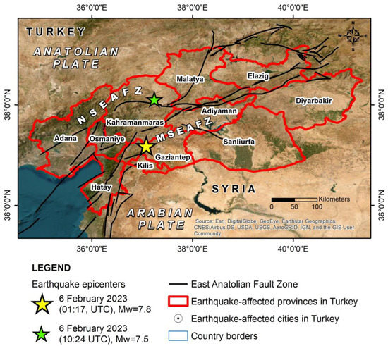
Figure 1.
The epicenters of the 6 February 2023 earthquakes along the East Anatolian Fault Zone (EAFZ) based on the United States Geological Survey (USGS) [9,10]. The Mw = 7.8 was generated in the main strand of the EAFZ (MSEAFZ) and the Mw = 7.5 earthquake in the northern strand of the EAFZ (NSEAFZ). 11 provinces were affected by the earthquakes with their largest cities heavily affected by the earthquake ground motion and related primary and secondary effects resulting in tens of thousands of fatalities.
The synergy of the strong ground motion [11] combined with the generation of extensive primary effects, such as coseismic surface ruptures, and the triggering of secondary effects, including liquefaction and landslides among others [12,13], resulted in tens of thousands of buildings with heavy and very heavy structural damage including total or partial collapse and large parts of residential areas being flattened [12,14,15]. In addition, several infrastructures and in particular parts of the road network were damaged. This impact on the built environment created a volume of debris that is difficult to manage even in organized countries.
The motivation for conducting this research came from the 6 February 2023 earthquakes that struck East Anatolia and the several examples of earthquake debris management we identified during our field surveys conducted in the earthquake-affected area of southeastern Turkey. We followed the debris management unfold in the Hatay, Kahramanmaraş, Gaziantep, and Adiyaman provinces, which are among the most affected provinces of East Anatolia.
The scope of the study includes the analysis of the approaches applied for debris disposal in southeastern Turkey after the 6 February 2023 earthquakes for the identification of correct and incorrect responses. Furthermore, it includes the identification of the factors with a high potential for adverse effects on the natural environment and public health in earthquake debris disposal sites detected in southeastern Turkey as well as the proposal of risk mitigation strategies for reducing the associated risks for all involved in debris management and for the significant elements of the natural environment observed in the studied areas.
The principal aim of this research is for the scientists, the operational staff, and the affected residents in Turkey to become aware of the errors and omissions in debris management and to acquire the knowledge to implement measures to deal with and mitigate the potential adverse effects on the public health and the natural environment of East Anatolia. Furthermore, it aims to highlight the good and bad practices (correct and incorrect responses) applied by all involved in debris management during the recovery period and the threats posed to public health and the natural environment in order to be avoided in future destructive events.
Particular reference to the seismic hazard and the impact of the 6 February 2023 earthquakes on the built environment of East Anatolia and to earthquake debris disposal sites in the earthquake-affected area will be made in the following sections. In addition, this research provides a review of the risks that emerge from the early stages of debris removal, when workers operate in disaster-affected areas up to the final stages of storage, sorting, and disposal. In addition, emphasis will be placed on the environmental risks posed in the frame of this recovery action by the uncontrolled debris disposal in areas that are particularly sensitive and vulnerable to hazardous substances and materials contained in the debris. In the same context, measures will be proposed to mitigate the adverse effects of debris management on the health of all involved including workers, volunteers, and the local population and the natural environment comprising the soil, the surface and groundwater bodies, and the air.
2. Methodology
We obtained the data to be presented below during post-event field surveys in the earthquake-affected East Anatolia. The first field survey was conducted shortly after the generation of the major shocks, from 6 to 11 February, when collapse debris were moved and urgent demolitions were carried out in order to facilitate search and rescue operations and hazard mitigation. The second field survey was implemented two months after the generation of the major shocks, from 31 March to 6 April, when the recovery phase had started and included actions such as the demolition of dilapidated and severely damaged buildings, establishment and operation of debris disposal sites and removal of debris from the earthquake-affected area.
In terms of the authors’ involvement in the disaster-affected area, E.L. visited the area shortly after the 6 February 2023 earthquakes as President of the Earthquake Planning and Protection Organization (EPPO, OASP in Greek) and a member of the Greek Search and Rescue (SAR) mission, which immediately responded to the Turkish government’s request for immediate assistance. The Greek SAR operation included special disaster response teams, Hellenic Fire Service officers and engineers, medics and rescuers from the National Emergency Response Centre, and the EPPO’s President [16]. The Greek SAR team worked in the Antakya district of Hatay province, which is located in the southwestern section of the damaged area. SAR activities in the region resulted in the rescue of five persons and the retrieval of five unconscious people from the rubble [16].
The other authors, S.M., E.V., I.A., and P.C., visited the earthquake-affected area as part of the research mission of the Department of Geology and Geo-environment of the National and Kapodistrian University of Athens [12].
During fieldwork, we visited all the affected provinces with emphasis on the largely affected urban centers and their surrounding areas in order to realize where and how the very large amount of collapse and demolition debris will be disposed of during recovery and restoration. In this context, we identified fully operational disposal sites in four of the most affected provinces in the southeastern part of Turkey. These sites and their surrounding area were mapped by applying innovative methodologies first in the field and then back in the laboratory. The former involved the deployment of Unmanned Aircraft Systems (UAS) comprising drones and the latter remote sensing.
Unmanned Aircraft Systems (UAS) offer significant potential for effective debris management [17], which could bring the management and safety of these sites to different levels. In the frame of this study in devastated southeastern Turkey, the drones deployed at the earthquake debris disposal sites provided a quick and convenient way for their on-site recognition in the most earthquake-affected provinces of southeastern Turkey and analysis of their location. Furthermore, they contributed to the analysis of the spatial properties not only of the studied sites but also the surrounding elements of the natural and built environment. We identified the extent and the borders of the disposal sites, the type of earthquake debris, and the main debris management actions including crushing of concrete and sorting the iron of the building reinforcement among others. We also detected the type of the surrounding natural habitats and residential areas that are most likely to be adversely affected by debris management. As regards compliance with the international standards and best practices for debris treatment and disposal, the unmanned aerial photo imaging helped to assess the technological and environmental safety not only in the disposal sites but also in several segments of the urban and rural road network used for debris transport.
We used imagery acquired by the Planetscope satellite constellation [18], which was kindly offered for our research through the online explore platform. By using these datasets, we succeeded in working with high spatial resolution images (3 m), took advantage of the near-infrared band in addition to the visual spectrum, and finally chose cloud-free days, due to the high frequency revisiting time. The near-infrared band (845–885 nm) was assigned to the Red color, the red band (650–680 nm) was assigned to the Green color, and the green band (547–583 nm) was assigned to the Blue color, generating pseudocolor image maps. The latter provides a nice contrast between areas that are covered with vegetation due to the high reflectance of chlorophyll and objects on the earth’s surface that consist of concrete (buildings damaged or not, disposal sites), asphalt (paved roads, debris) or synthetic material (tents, containers, hovels) [19,20,21]. These remote sensing observations included multi-temporal, geo-referenced imagery interpretations of the same areas acquired some days before the February earthquake and almost four months later. The purpose of using these methodologies was to capture the dimensions, the properties, and the actions that were taking place within these sites and the potential presence of human activity and structures (buildings and infrastructure) as well as natural ecosystems that could be adversely affected by the operation of these sites.
3. Seismic Hazard in the East Anatolia and the 6 February 2023 Earthquakes
Turkey is among the most earthquake-prone countries in the world, suffering from earthquakes with Mw ≥ 5.5 almost on a yearly basis [22], events characterized by high potential for adverse effects on the built environment and the population. The North Anatolian and the East Anatolian Fault Zones are major earthquake tectonic structures that are responsible for the generation of many damaging earthquakes not only during antiquity and the historical period but also during the period of instrumental recordings [23,24]. The high level of seismic hazard in Turkey could be highlighted by the recent generation of destructive earthquakes with Mw ≥ 6.0, namely the 24 January 2020 Mw = 6.8 Elazığ earthquake [25,26], the 30 October 2020, Mw = 7.0 Samos earthquake [27,28,29,30] and the 23 November 2022 Mw = 6.1 Düzce earthquake [31]. Many other seismic events have occurred in the past and are among the largest and most destructive earthquakes worldwide such as the 17 August 1999, Mw = 7.6 Izmit earthquake [32,33], among others.
The EAFZ constitutes a left-lateral transform plate boundary, which dominates East Anatolia and greatly affects the geodynamics and active tectonics in the area [24,34,35,36]. It extends from Karlıova Triple Junction in the north, where it meets with the North Anatolian Fault Zone, to Antakya in the south, where it joins to the Dead Sea Fault, and constitutes a complex boundary separating the Anatolian plate located northwestwards from the Arabian plate located southeastwards [24,36]. Its western part constitutes a 65 km wide deformation zone which comprises two strands: the northern and the main which are also segmented [24]. The main strand of the EAFZ is composed of seven segments, including the Erkenek, Pazarcık, and Amanos segments [24]. The northern strand has an average E-W direction, while close to its eastern termination its strike changes from E-W to NE-SW. The E-W striking fault system is structured by the Sürgü and Çardak segments, while the western part of the northern strand comprises eight segments [24].
The EAFZ constitutes the main damaging earthquake source in the East Anatolia. It has been characterized by considerable earthquake hazards in the past and many destructive earthquakes occurred on the fault zone during the historical and instrumental period with extensive damage on the built environment and great loss of life [24,35,37,38] The EAFZ seems to be more active in the 21st century with the occurrence of the 27 June 1998, Mw = 6.3 Adana-Ceyhan earthquake [39], the 1 May 2003, Mw = 6.4 Bingöl earthquake [40], the 8 March 2010, Mw = 6.1 Başyurt (Elazığ) earthquake [41], the 23 October 2011, Mw = 7.1 Van earthquake [42] and the 24 January 2020, Mw = 6.8 Elazığ earthquake [38]. These events highlighted the seismic hazard of the East Anatolia.
On 6 February 2023, East Anatolia was hit by two devastating earthquakes. The epicenter of the first major shock was located at a distance of 37 km west-northwest of Gaziantep city according to the related information provided by the US Geological Survey [9] (Figure 1). It was a shallow event, with a focal depth of 12 km [43] and it was caused by the rupture of a NE-SW striking near-vertical left-lateral strike-slip fault according to the related information provided by several seismological institutes and observatories [44]. The properties of the Mw = 7.8 earthquake as well as its focal mechanism are consistent with the events that occurred along or close to the EAFZ and the Dead Sea Fault Zone, which accommodates the westward extrusion of the Anatolia plate into the Aegean Sea region and the northward motion of the Arabian plate relative to the Africa and Eurasia plates respectively (Figure 1).
An Mw = 6.7 aftershock followed 11 min after the generation of the first shock, while 9 h later a new major earthquake was generated along the EAFZ. Its epicenter was located along the northern strand of the EAFZ, at a distance of 33 km south of Elbistan [10] (Figure 1).
Both earthquakes generated on 6 February 2023 caused extensive primary and secondary environmental effects in the earthquake-affected area [12,13,45]. The first comprised mainly surface ruptures along with local uplift and subsidence, while the latter included ground cracks, slope failures, liquefaction phenomena, tsunamis, and hydrological anomalies in East Anatolia [12,13,45]. These events along with the strong ground motion caused extensive impact on the buildings and infrastructures of the affected residential areas resulting in not only structural and non-structural damage but mainly heavy loss of life [12,14,15].
The earthquakes caused a widespread impact on the natural and built environment of the southeastern Turkey and the northwestern Syria [12,14]. The southeastern earthquake-affected part of Turkey is home to nearly 14 million people (14,013,196 people in 2022), corresponding to 16.4% of the total population of the country [15,46]. 96.7% (13,553,283 people) of the population of the affected areas resided in provincial and regional centers and the rest in towns and villages. Additionally, 1,738,035 people are migrants mainly from Syria residing under temporary protection.
4. Impact of the 6 February 2023 Earthquakes on Structures and Earthquake Debris
4.1. Earthquake Damage on Dominant Building Types and Controlling Factors
The 6 February 2023 seismic events flattened a total of 11 provinces in southeastern Turkey which in alphabetical order are the following: Adana, Adıyaman, Diyarbakır, Elazığ, Gaziantep, Hatay, Malatya, Kahramanmaraş, Şanlıurfa, Kilis, and Osmaniye [15]. The total number of buildings in the earthquake-affected provinces is 2.6 million. Residential buildings hold a percentage of 90%, while public buildings hold 3% and businesses 6%. The housing units amounted to 5.6 million in 2022, which corresponds to a percentage of 14.5% of the total in the country [15].
The main building category in the affected provinces comprises reinforced-concrete frame buildings holding a percentage of 86.7%, with prefabricated buildings, masonry buildings, and steel structures following in much smaller percentages at 3.6%, 3.5%, and 2.4%, respectively.
The damage observed in reinforced-concrete buildings are attributed to several factors including inadequate structural designing, the city planning violations, such as building/covering semi-open spaces (cantilevers), the lack of unified urban planning zones, the improper foundation systems (shallow mat foundation on loose soils), and ignoring the distinct soil characteristics or considering them as uniform throughout the construction area [12].
The least resistant buildings in terms of their anti-seismic behavior were the masonry buildings. They mainly suffered from out-of-plane behavior and corner failure attributed to the combination of the in-plane and out-of-plane failure behaviors [47]. The main reason for the damage observed in masonry buildings is the non-compliance of their construction with seismic design codes [48]. The poor workmanship along with low-strength wall and the absence of joint building materials are the main reasons leading to heavy and very heavy structural damage [47,48] (damage grades 4 and 5 based on the European Macroseismic Scale EMS-98 [49]) comprising total or near total collapse.
The structures in the earthquake-affected area of East Anatolia include residential, public, and industrial buildings and infrastructures based on their pre-seismic usage. The first category of residential structures suffered heavy and very heavy structural damage [15] corresponding to damage grades 4 and 5 respectively based on the EMS-98 [49]). Public buildings comprise hospitals, police and fire departments, and other administrative structures. Some of them, particularly health facilities including base-isolated and fixed-base buildings, demonstrated superior performance in terms of achieving the goal of immediate occupancy and providing better protection for nonstructural elements, whereas the latter achieved the goal of collapse prevention despite being very close to the coseismic surface fault ruptures and subjected to higher-than-design-level ground motion [50]. As regards the historical masonry mosques and minarets, their majority were heavily and very heavily damaged or completely collapsed after the earthquakes’ occurrence. Damage to mosques was mainly observed in the dome, carrier walls, and minaret, while minaret damage was mainly observed in transition sections and spire parts [51]. The detected damage in this type of public buildings is attributed to the absence of any code or directive for these special structures [51].
Regarding the initial damage assessments, it is revealed that the 6 February earthquakes did not generally generate significant damage to industrial facilities including small industrial sites and organized industrial zones [15]. However, as it emerged from our field survey, the damage was locally heavier, particularly in areas close to coseismic surface ruptures, such as in the Türkoğlu area (Kahramanmaraş Province) as well as in areas founded on recent river deposits, such as the small industrial site in the northern part of Antakya city, west of the Asi (Orontes) riverbed.
Infrastructure includes, among other things, transportation networks, communication systems, and energy and water supply networks. Multiple highways and bridges near the surface fault ruptures were severely damaged and were entirely inoperable for the first few days. Due to damage, a few power plants remained down, although the power grid recovered quite quickly. When power was fully restored, hydroelectric dams resumed operation. Lines of communication with the impacted region were also disrupted.
Until 6 March 2023, i.e., one month after the occurrence of the catastrophic earthquakes, 1,712,182 buildings in the 11 affected provinces were checked by the competent authorities. 35,355 buildings collapsed, 17,491 had to be demolished immediately, 179,786 suffered severe damage, 40,228 moderate damage and 431,421 slightly damaged [15] (Table 1). As a result of the synergy of the strong ground motion and the generated very heavy structural damage on buildings, 50,399 human casualties, and 107,204 injuries were reported and 2.5 million homeless people were accommodated in temporary settlements, while 1.6 million of them in unofficial settlements [15].

Table 1.
Results of the post-event buildings inspection and damage assessment in the 11 provinces of the southeastern part of Turkey based on the data presented by the Ministry of Environment, Urbanization and Climate Change of Turkey until 6 March 2023 [15].
4.2. Earthquake Debris Composition and Volume
Based on an estimation made by the United Nations Development Programme (UNDP) [52], the 6 February 2023 earthquakes caused between 116 and 210 million tonnes of debris which constitutes one of the largest debris volumes recorded from a disaster associated with or caused by a natural hazard since the 17 January 1994, Mw = 6.7 Northridge (Southern California, United States) earthquake (Table 2). Furthermore, Xiao et al. [53] estimated the demolition debris generated by the 6 February 2023 earthquakes by applying two different approaches. The first one takes into account the number of the earthquake-affected population, the average housing area per person, and the amount of demolition debris generated per unit housing area. Based on this information, Xiao et al. [53] predicted that between 520 and 840 million tons of debris were generated by the earthquakes (Table 2). The second approach takes into account the amount of damaged buildings and in particular the estimated number of collapsed or damaged buildings, the proportions of reinforced concrete and masonry structures, and the average building areas of reinforced concrete and masonry structures, considered as the dominant building types in the earthquake-affected area. Based on this information, Xiao et al. [53] predicted that between 450 and 920 million tons of debris were generated by the earthquakes (Table 2).
Table 2.
The volume of debris produced by earthquake disasters worldwide. (M: moment magnitude, I: Intensity, DV: Debris volume in million tonnes; HL: Human losses, IP: Injured people, TA: Total affected people). Information about M, I, HL, IP, and TA are extracted from the International Disaster Database (EM-DAT) [54]. The sources of debris volume (DV) estimation are presented in the table.
The aforementioned data reveals that the 6 February 2023 earthquakes in Turkey resulted in a very large debris volume, whose values show a wide range depending on the estimation method. If we consider the larger values estimated by Xiao et al. [53], then the debris volume in East Anatolia is by far the largest that has been caused by a natural disaster for the time period considered (Figure 2). If we take into account the smaller values, as estimated by the UNDP [52], the volume of debris is again among the two largest produced after an earthquake for the aforementioned time period. In this case, the debris volume produced by the 2023 Turkey earthquakes holds second place after the 380 million tonnes of debris generated by the 12 May 2008, Mw = 7.9 Sichuan (China) earthquake [4] (Table 2; Figure 2).
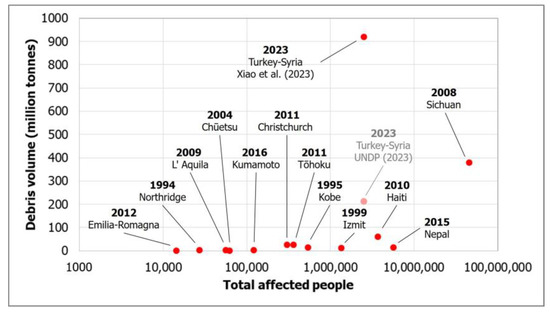
Figure 2.
Debris volumes (in million tonnes) generated by earthquakes worldwide from 1994 to 2023 against the total affected people based on the data presented in Table 2. The maximum estimated volume is taken into account for each seismic event. The diagram contains data from 1994 to 2023 including the 2023 Turkey-Syria earthquakes based on Xiao et al. [53] and UNDP [52].
It is important to mention that most of the devastating earthquakes generated worldwide during the last 25 years have caused debris volumes that do not exceed 60 million tonnes (Table 2; Figure 2). An example of an earthquake in the same country and with almost similar magnitude, which can be used for comparison, is the 17 August 1999, Mw = 7.6 İzmit earthquake generated in the western part of the North Anatolian Fault. This event produced a much smaller debris volume, about 13 million tonnes [5].
The presented information may also prove to be a useful tool for the agencies involved in disaster prevention and management, with which they can easily estimate an average amount of debris generated based solely on demographic data, both at the pre-disaster phase during implementing the emergency and earthquake disaster impact management plans, and at the post-disaster phase during the preparation and implementation of emergency response and recovery actions.
As far as the composition of earthquake debris, Xiao et al. [53] considered reinforced concrete and masonry buildings as the prevailing building types in the earthquake-affected area and they studied major construction materials for the prevailing structures before the earthquake for the prevailing types of structures. They concluded that the waste bricks and concrete are the main components of the demolition waste produced by the 6 February 2023 earthquakes with percentages of 59.0% and 28.6% respectively in the overall composition of debris, with timber (5.9%), roofing tiles (2.6%), plastics (2.0%), metal (1.3%), glass (0.3%), and other materials (0.2%) following [53].
Taking into account these numbers, we realize the magnitude, intensity, and extent of the earthquake disaster in Turkey and worldwide and understand that one of the biggest challenges during the recovery period is the proper and efficient removal, treatment, and disposal of debris in a way that does not create new hazards and threats to the health of all involved in debris management including volunteers and the local population and to the balance of the natural environment.
With this in mind, we will present examples of debris management in the earthquake-affected East Anatolia that deviate from the standards of safe and effective management. This approach aims to highlight the poor practices followed during the recovery period and the risks arising from these practices to public health and the balance of the natural environment. Furthermore, it aims to avoid similar practices in the future.
5. Debris Management and Related Hazards in the Earthquake-Affected Provinces in Turkey
5.1. Hazards Emerging during Earthquake Debris Management
Among the most hazardous phenomena during earthquake debris management is the formation of dust clouds at collapse, demolition, and debris disposal sites that can contain damaged structural and non-structural materials with asbestos fibers [65,66,67,68,69]. All workers, volunteers, and residents exposed to asbestos fibers are characterized by a high probability of developing infectious diseases including asbestosis, lung cancer, mesothelioma, cancer of the esophagus, stomach, colon, and pancreas, pleural plaques, pleural thickening, and pleural effusion [68,69,70,71,72].
Another hazard to which all those involved in earthquake debris management can be exposed is perishable products, which spoil and constitute a breeding ground for bacteria such as Salmonella, Escherichia coli, and Campylobacter spp. If consumed, these bacteria can cause foodborne illnesses, presenting with symptoms such as diarrhea, abdominal pain, nausea, and vomiting. Additionally, food left exposed to moisture and inadequate ventilation could create conditions favorable for mold growth and formation of mold substances, which can lead to allergic reactions, respiratory issues, and, in some cases, mycotoxicosis via inhalation, ingestion, and skin contact [73].
Heavy metals including chromium, copper, and arsenic used as preservatives to increase the resistance of wood to corrosive agents have a high potential to threaten all involved in earthquake debris management. Treated wood included in the debris is a detrimental factor especially when arsenic, copper, and chromium are leached in large concentrations [74,75,76], when mixed with untreated wood in recycling operations where the resulting product is contaminated to such an extent that it cannot be applied to soil, and when incinerated and heavy metal emissions require the use of appropriate air pollution control equipment [77,78,79,80,81]. The exposure of those involved in various steps of disposing treated wood to decaying materials leached into soils and waters as well as residents who may come into contact with the residues and products of this treatment through the natural environment (surface water and groundwater bodies and soils) may suffer damage to mucous membranes in the peripheral and central nervous system, parts of nervous tissue and hearing ability [82,83], increasing incidence of cancer in the urinary bladder, kidney, liver, lung and skin [84,85,86,87], irritation and rashes on the skin and erosion and irritation of the respiratory tract airways causing damage to mucous membranes and development of lung cancer [88,89].
Another infectious disease that can affect workers, volunteers, and residents taking part in debris management is tetanus, an infectious disease caused by exposure of wounds to Clostridium tetani spores. During the evacuation, debris removal, and subsequent demolitions, there is an increased risk of causing injuries, e.g., punctures to the skin, cuts and abrasions. Any break in skin continuity is a way for bacteria to penetrate the human body and cause tetanus. Tetanus outbreaks have been already reported after the 2004 Indonesia, the 2005 Kashmir, the 2006 Yogyakarta, and the 2010 Haiti earthquakes [90].
Milder debris management impact but equally important for returning residents to normality and ensuring the balance of the natural environment comprises the noise and visual pollution in debris disposal sites. This type of pollution can be attributed to many factors and practices adopted during debris management such as the use of heavy machinery and equipment during demolition and transportation, the increased traffic during debris transport, the selection of inappropriate debris disposal sites near either residential areas or sites with scenic ecological value and sensitive natural landscape. These actions can significantly affect the tranquility in a residential area and the equilibrium in sensitive natural habitats.
In addition to these effects of the hazardous elements of debris on humans, debris management can have also adverse effects on the environment in a number of ways, the most important of which are water and soil contamination and the destruction of natural habitats. Earthquake debris can introduce pollutants such as heavy metals and other chemicals that can contaminate nearby water bodies including rivers and streams, lakes, lagoons, marshes, and the sea with long-term effects on surface water ecosystems (e.g., [91]). When these materials enter water bodies, they have the potential to cause deterioration in water quality and make it unsafe for supply and irrigation and dangerous for aquatic life.
Earthquake debris can have an impact on air quality. The processing of debris from damaged buildings and infrastructure can create a significant amount of dust and particles which can become airborne and contribute to poor air quality not only in collapse, demolition, and debris disposal sites but in heavily affected large residential areas (e.g., [92]).
As regards natural habitats, improper disposal practices such as dumping debris within or close to water bodies can disrupt natural ecological processes and water flow patterns, cause sediment accumulation, and affect aquatic organisms by limiting available oxygen and blocking sunlight. Segmentation and destruction of habitats can obstruct wildlife migration routes, disrupt breeding areas, prevent nutrient recycling, and alter food and shelter availability. The ecological balance can be disrupted by debris containing soil, seeds, or other materials that contain non-native or invasive species. These changes have the potential to cause cascading effects on the entire ecosystem, its biodiversity, its population dynamics, and the overall resilience of natural habitats.
5.2. Debris Management and Related Hazards in the Earthquake-Affected Provinces in Turkey
In this chapter, examples of debris disposal sites at various parts of the earthquake-affected areas of East Anatolia will be discussed. These sites were observed during a field survey conducted by the authors two months after the earthquake, in particular from 31 March to 6 April 2023. The sites were located in the southern, central, and northern parts of the earthquake-affected region, especially in the cities of Samandağ, Antakya, Nurdağı, Gölbaşı, Kahramanmaraş, and Adıyaman (Figure 3).
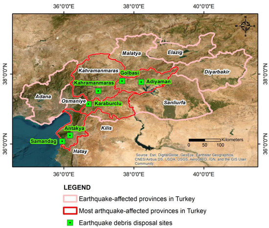
Figure 3.
Map depicting the locations of earthquake debris disposal sites set up in the provinces of southeastern Turkey most affected by the 6 February 2023 earthquakes. The words in italics correspond to the provinces’ names.
5.2.1. Samandağ Disposal Site
This site is located in the coastal area of Samandağ (Figure 4), which is a town in Hatay province at the southern end of the earthquake-affected area. This town is located on the Orontes River delta and most of it is founded on recent deposits. In this area, there is an interaction of rivers and marine processes that have formed an important ecosystem with different habitats such as sand dunes, marshes, lakes, and rivers, characterized by high biodiversity (Figure 4). Many of them, including dunes and marshes, are particularly sensitive to human intervention and may disappear under constant pressure.
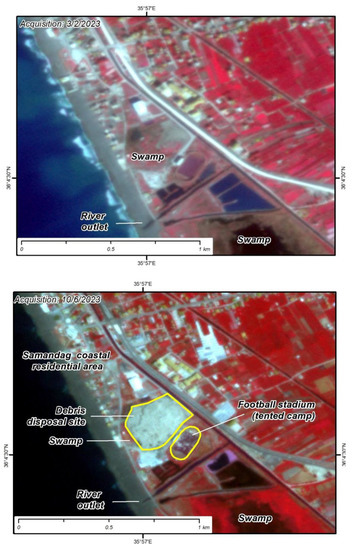
Figure 4.
Pseudocolor image maps in the Samandağ disposal site area before (first map, acquisition on 3 February 2023) and after (second map, acquisition on 10 June 2023) the initiation of earthquake debris removal. Four months after the earthquake the unsorted earthquake debris pile has entirely covered the former swamp area formed north and west of the stadium.
In the Orontes River delta, the Samandağ sand dunes are also developed. They constitute one of the most important nesting and foraging habitats for green turtles in the Mediterranean [93,94]. In particular, the nesting area of Chelonia mydas is restricted to the Eastern Mediterranean including Samandağ beach [94]. Furthermore, the Samandağ marine area is characterized by impressive offshore geomorphs including caves whose formation has been attributed to the intense tectonic processes in the area. A plethora of marine species mainly fishes from the Mediterranean Sea and the Red Sea are also present. This has made the area a popular destination for diving tourism which, due to the ideal temperatures, remains functional throughout the year.
Apart from the high ecological value of this coastal area, its historical value is equally great. Samandağ is located near the site of ancient Seleucia (Seleukeia) Pieria which was founded in 300 BC after the expulsion of the Persians from the area by the emperor Seleucus I Nicator, Macedonian Greek General, officer, and successor of Alexander the Great. Seleucia Pieria quickly became an important Mediterranean port of the Hellenistic and Roman era. According to the results of geomorphological studies conducted by Erol and Pirazolli [95], the area has suffered two rapid uplift movements, probably of seismic origin during the late Holocene. The first one, occurred about 2500 ± 100 years BP, caused a local vertical displacement of about 1.7 m, while the second one generated around 1400 years BP, in May 526 AD was followed by a 0.7 to 0.8 m uplift [95] and devastated Antioch and Seleucia. The second earthquake also triggered a tsunami and a rapid silting of the Seleucia Pieria closed harbor basin and entrances resulting in disruption in the port operation.
However, the Orontes River delta including the Samandağ dunes and their surrounding areas are under great pressure from human activities and more specifically from urbanization [96]. Due to population growth, agricultural land has shrunk, forests have been destroyed and pastures have decreased in size. Chemical fertilizers and agricultural pesticides were used extensively and a large number of agricultural machines were used to increase production. Other factors that have degraded the natural environment of the area are the extraction of sand from the coastal zone, the dumping of organic and inorganic wastes, and the construction of country houses, hotel facilities, and leisure and entertainment facilities including restaurants and a football stadium (Samandağ Deniz Stadyumu) (Figure 4) among others. These activities have converted a large part of the dunes into agricultural land and then into construction sites [96]. In addition to the above interventions, which have been highly detrimental to the coastal environment of Samandağ, another action that is characterized by a high potential to cause significant impact on both the ecosystem and the local population is the establishment of a debris disposal site in the coastal area of Samandağ, in particular immediately north of the stadium of the city (Figure 4).
This disposal site is located just 20 m southwest of the above field, 30 m from the coastal road, and 150 m from the coastline (Figure 4). During our field survey in the southernmost end of the earthquake-affected area in early May 2023, we found that due to the continuous dumping of debris from the earthquake at this location, a wide and high pile had been formed (Figure 5a). It was higher than the adjacent stand of the stadium (Figure 5b), while it also occupied a large part of the marshy area west of the field (Figure 5a,c).
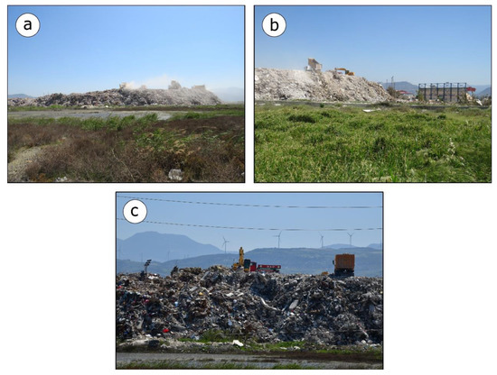
Figure 5.
Views of the Samandağ disposal site. Dust clouds were constantly formed (a,b) due to the limited prevention measures applied during treatment. (b) The pile was formed very close to a stadium where a tented camp had been set up. (c) Several types of debris in the pile reveal no sorting at all and cover a large part of the coastal swamp west of the stadium.
A characteristic of the earthquake debris management at this site was the constant arrival of trucks and the dumping of the debris at the top and side of the debris pile without any other intermediate treatment for sorting materials. Particularly on the slopes of this debris pile, the presence of various materials was evident, for example, concrete, steel reinforcement bars, household waste, white appliances, soil material, etc. (Figure 5c). This mixture of materials makes this assemblage very dangerous for water bodies and the local population. Due to the mixing of many materials of different types and origins from different and distant areas, soil, seeds, or other materials containing non-native species may be unintentionally introduced into the local environment and then dominate and disturb the native flora and fauna with chain reactions and expansions up to the local human population.
This indiscriminate dumping of earthquake debris endangers both surface and underground water bodies in the area. Marshes and rivers formed in the surrounding area will be degraded immediately by surface water contamination by rubble, chemicals, and hazardous material of the earthquake debris and by subsequent water quality degradation that will make the water unsafe for human consumption and the aquatic life with high potential for long-term effects.
As shown in the case of the 21 May 2003, Mw = 6.8 Boumerdès (Algeria) earthquake [91], the effects are not limited to surface water but they could be expanded to groundwater. Due to the fact that the Samandağ site is developed in a coastal environment very close to both a river and the sea, the depth of the groundwater is small, resulting in hazardous material either dissolving or leaching into the groundwater. Contaminated water can have a long-term and negative impact on both humans and any living organism in the area.
The proximity of the debris pile to the sea can also affect marine organisms and the balance of the marine system through surface water supply from the adjacent river or subsurface flow from the aquifer.
As far as air quality is concerned, it will certainly be affected by debris management at this site. The earthquake-affected people who have settled in the tents within the Samandağ stadium are those directly affected by the generation and the transport of the dust clouds. Because Samandağ is characterized by the most significant wind energy potential in Turkey [97], it is possible and probable that the generated dust and hazardous particles could be transported over long distances and affect the health of not only the residents of the adjacent areas but also of a large part of the city.
As regards the impact on the natural environment, the occupation of part of the marshland alone can cause segmentation and barrier effects in the ecosystem with all that this entails as we have seen in the movement and dispersal of wildlife, migration routes, and gene flow between populations. It can also disrupt ecological processes such as wildlife migration, reproduction, nutrient cycling, and food and shelter availability.
From the above data, it is concluded that the debris management actions during the emergency response and recovery phases are not in line with current best practices for reducing disaster impact and risk. The selection of the football field in the coastal area as a camp for the accommodation of earthquake-affected people and the selection of the marsh as a disposal site for untreated earthquake debris are typical examples of mismanagement and should be considered examples to be avoided in future events.
It is important to note that there have been reactions from residents to the choice of both sites and the related potential impacts and risks. However, the operation of the debris disposal site have continued uninterrupted. Based on Planetscope satellite imagery acquired on 10 June 2023, one month after our field survey in the earthquake-affected area, it is revealed that the earthquake debris disposal continued resulting in the partial covering of the swamp area west of the stadium.
5.2.2. Antakya Disposal Site
Antakya is the capital of Hatay province and is one of the cities that were very heavily affected by the 6 February 2023 earthquakes. It is located in the southern part of the earthquake-affected area and in particular within the NE-SW striking Antakya-Samandag Corridor that has been formed between the Amik Basin and the Carpathian Arc [98]. Within this depression, the Orontes River develops in a similar direction and flows southwards, south of Samandağ, making the area vulnerable to intense earthquake ground motion. The most recent part of the sedimentary fill includes Holocene alluvial deposits on either side of the Orontes River, comprising pebbles, sands and clays [98]. Pleistocene-age river terraces are also developed, which are composed of alternations of pebbles and coarse sands [98].
Due to the high value of the peak ground acceleration in the part of the city west of the Orontes River [14] and the construction of buildings in an area composed of recent geological deposits [98], highly susceptible to liquefaction and lateral spreading phenomena, the buildings in the city suffered very severe structural damage including a few thousand collapses located within a distance of up to 2 km from the riverbed and tens of thousands of buildings with very severe damage throughout the city. The heavy structural damage resulted in many of the buildings having to be demolished. The demolition along with the collapsed buildings created a large amount of debris that had to be removed from the city and therefore the need for the establishment of debris disposal sites.
During our field survey in Hatay province, we found that the demolition of buildings and the removal of debris in Antakya City was in progress. We also identified disposal debris sites that did not meet even the basic criteria for their setup. One of these sites was located at the northwestern boundary of an area with small industrial sites (Figure 6).
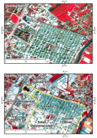
Figure 6.
Pseudocolor image maps in the Antakya disposal site area before (first map, acquisition on 2 February 2023) and after (second map, acquisition on 10 June 2023) the 6 February 2023 earthquakes.
One of the main disadvantages of this location as a debris disposal site is its small distance from areas where people live and work. This site was immediately east of Atatürk Cd, one of the main roads in Antakya with a lot of traffic leading from the main urban fabric of the city to its northern suburbs and small industrial sites (Figure 6). In addition, it is located right next to a branch of the drainage network that flows from northwest to southeast and ends in the main branch of the Orontes River (Figure 6) that crosses the urban fabric of the city, dividing it into eastern and western parts and feeding the groundwater. From the above, it is concluded that the treatment of debris at this location has the potential to affect not only the health of the local population but also surface water bodies and groundwater systems and a larger part of the population of the city which uses the aforementioned sources for various purposes.
This disposal site was filled with water and covered with rubble in its northern and eastern parts (Figure 7). Characteristic of this area was the constant arrival of trucks loaded with rubble that were dumped near the edges of the pile, and pushed with heavy machinery into the water. This process resulted in the continuous formation of dust clouds.
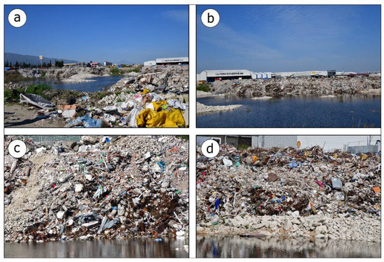
Figure 7.
Typical views of the unsorted earthquake debris dumped in the Antakya site on 4 April 2023. (a,b) The area was entirely covered by water before debris dumping forming a small water body very close to a stream flowing to the Orontes River. During recovery, the site has been selected for disposal of unsorted earthquake debris (c,d). Τhe chaotic mixture contained mainly concrete and steel reinforcement bars from collapsed and demolished buildings as well as various damaged construction materials and related equipment.
The health of the local population may be directly affected by dust clouds. Residents may experience adverse effects from the occurrence of respiratory infectious diseases and eye diseases. The local population may also be affected by odor and nuisance as well as from the noise during the processing and disposal of debris and the view of the debris pile.
An indirect impact on the health of the city’s population can come from pollution of surface and groundwater bodies. The debris contains heavy metals, oils, and other hazardous materials that can enter the stream and river through rainfall and runoff and thus into the aquifer, affect all sources of drinking and irrigation water, and cause diseases associated with water contamination (skin irritations, respiratory diseases, water-borne diseases, and long-term health effects).
5.2.3. Karaburçlu Disposal Site
This site is located about 4.5 km southwest of the city of Nurdağı which was severely affected by the February 2023 earthquakes resulting in very heavy structural damage to thousands of buildings including hundreds of collapses and about 2500 human casualties according to official statements by the Turkish authorities. In particular, the Karaburçlu site is located between the D825 state road and the Karaburçlu settlement at a distance of about 100 m from its eastern boundary (Figure 8). Prior to the earthquake, the site was used as an aggregate extraction site with a perimeter of almost 1.2 km and an area of 0.07 km2. Two months after the earthquake, the site was converted for treatment and disposal of the earthquake debris (Figure 9a).
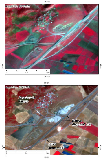
Figure 8.
Pseudocolor image maps in the Karaburçlu disposal site area before (first map acquired on 24 January 2023) and after (second map acquired on 11 June 2023) the 6 February 2023 earthquakes.
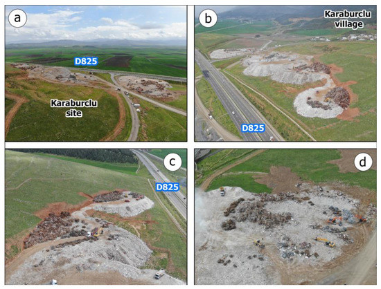
Figure 9.
Characteristic drone views of the Karaburçlu earthquake debris disposal site during a post-event field survey conducted by the authors in the earthquake-affected area on 5 April 2023. (a) Drone view from west to east with the D825 state road passing east of the site. (b) Drone view from north to south with Karaburçlu village located at a small distance of about 100 m from the eastern boundary of the site. Dust was constantly present due to the crushing of concrete during debris treatment not only over the site but also in the wider area including the settlement. (c,d) The debris treatment in the Karaburçlu disposal site included concrete crushing and sorting of the steel. Steel balls were observed in the eastern part of the site (c,d).
During our field survey in the Nurdağı area on 5 April 2023, we found that debris processing including crushing of concrete and sorting of steel reinforcement bars was taking place (Figure 9b–d). This treatment was conducted with heavy machinery including crushers, hydraulic excavators, loaders, and heavy trucks. The steel bars were turned into balls that were piled up in the western part of the site towards the settlement (Figure 9b–d). The crushing of debris resulted in the creation of dust clouds at various stages of its processing from the very first phase of debris deposition on the site until its final compaction by loaders and rollers. Due to the fact that these activities continued all day with no interruption, there was a constant dust accumulation not only over the disposal site but also on the adjacent road and mainly towards the adjacent Karaburçlu settlement.
Considering the location of this site, the activities that take place in its boundaries, and the presence of large infrastructures and residential areas at a very short distance from the site, we can conclude that this site is unsuitable as it can create health risks for the workers in the disposal sites and the residents of the adjacent settlements. They may be confronted with infectious respiratory diseases such as pneumonia, asthma attacks, and exacerbation of pre-existing respiratory conditions or even with more serious diseases such as lung cancer in case the debris includes building and insulation materials with hazardous components such as asbestos.
In addition, the participation of heavy vehicles in the process at the disposal site leads to noise pollution due to the constant operation of the engines, the unloading of debris, and the loading of the steel for further recycling and use. In addition to noise pollution, visual pollution may also be generated by the constant presence of heavy vehicles on the local road network, the view of debris piles at the disposal site, and the change in the landscape caused by their accumulation.
Given that there are no significant water bodies such as rivers, lakes, lagoons, and marshes in the vicinity of this site, there does not appear to be an immediate risk of the disposal of debris disturbing the balance of such ecosystems. However, this does not exclude the impact on the groundwater in the area which may have long-term effects on the health of the local population.
5.2.4. Gölbaşı Disposal Site
Gölbaşı town is located in the northeastern part of the earthquake-affected area, in particular in a pull-apart basin created within a releasing stepover of the East Anatolian Fault zone between the Erkenek and the Pazarcik segments located northeast and southwest, respectively [24]. Within this basin and north of the town the Gölbaşı Lake has been formed. The area is composed of recent terrestrial and lacustrine deposits [24] that are particularly prone to liquefaction phenomena given the lithology, recent age, and the high groundwater table due to the proximity to the lake. Indeed, since the 6 February 2023 earthquakes, extensive liquefaction and lateral spreading phenomena occurred in the area, imprinted both along the lakeshore [13] and within the residential area, as it was concluded by our field survey in the earthquake-affected Gölbaşı town. These earthquake-triggered effects resulted in extensive damage to buildings, which could be characterized as typical of liquefaction phenomena, such as their sinking and tilting without other structural or non-structural damage to their superstructure, as well as their overturning and subsequent collapse in some cases.
The number of collapses may not have been so high but the localized damage to buildings from liquefaction, although allowing for the recovery of equipment and households and some non-structural materials of the buildings, make the demolition of buildings imperative. Thus, the collapses and demolitions created the need for a site, especially for debris removal from Gölbaşı town. An earthquake disposal site was established at the northeastern end of the city (Figure 10).
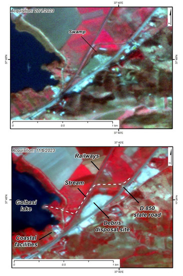
Figure 10.
Pseudocolor image maps in the Gölbaşı disposal site area before (first map, acquisition on 27 January 2023) and after (second map, acquisition on 11 June 2023) the 6 February 2023 earthquakes.
During our field survey in the area on 2 April 2023, it was in full operation. Among other activities, the steel reinforcement bars were separated from the concrete, as shown by various steel balls on the site, and the creation of a debris pile with a perimeter of approximately 650 m, and an area of 0.02 km2 (Figure 11a,b).
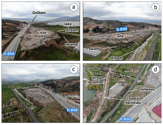
Figure 11.
Characteristic drone views of the Gölbaşı disposal site on 2 April 2023. (a) View from north to south. The Gölbaşı town is located south of the site. The site has been set up next to the D.850 state road and at a former swamp area (b), very close to the lake. Furthermore, a stream flows at a small distance from the site into the lake (white dotted line) (c,d).
As regards the morphological characteristics of the surrounding area, it is noted that the debris disposal site is bounded to the west and north by a stream that flows into the eastern part of Gölbaşı Lake (Figure 11c). This stream at the time of our field survey was filled with water, with a continuous flow towards the lakefront where entertainment facilities including a playground and a sidewalk among others have been constructed (Figure 11d). These facilities were heavily affected by ground cracks and subsidence along the lakefront attributed to lateral spreading triggered by the 6 February 2023 main earthquake.
Before the earthquake, a limited area of marshland occurred in the same location (Figure 10). It was fed by the aforementioned stream from a small opening in its banks. On 2 April 2023, this marshland was almost completely covered by the debris disposal activities (Figure 10). In terms of proximity to a residential area, this site is less than 200 m from the aforementioned recreational facilities and less than 1 km from the first residential buildings in the northeastern part of the town. Furthermore, the eastern boundary of the site is the D.850 state road that passes through the area (Figure 11). This road was very busy, especially during the emergency response after the earthquakes and then during the recovery phase.
From the above, it is concluded that the site is in a location that can adversely affect both public health and the natural environment. Public health may be directly affected by the dust clouds formed by the constant movement of heavy machinery in the site and along the local road network with effects comprising respiratory diseases among others as well as other long-term effects such as lung cancer attributed to the released asbestos fibers during the debris treatment. The natural environment and in particular the surrounding streams and the lake can suffer water contamination with heavy metals and oils through surface drainage, which will degrade the surface water quality with adverse effects on the riverine and lake area. These hazardous materials may also adversely and significantly impact the groundwater of the surrounding area. As an area in which a large lake has been formed and in which extensive liquefaction and lateral spreading phenomena have occurred, it could be concluded that the groundwater level is high and can be quickly affected by the hazardous materials, which can dissolve into the groundwater, resulting in degradation of the groundwater quality and subsequent impact on public health as this lake is an important source of both water supply and irrigation for the area.
These impacts may be expanded to the flora and the fauna that not only live in the lake and its shore but also use the lake for migration, temporary residence, and breeding. They may include the disruption of ecological processes, the introduction of new non-native and invasive species to the area, and even the destruction of the natural ecosystem.
5.2.5. Adiyaman Disposal Site
Adiyaman is located in the northeastern part of the earthquake-affected area and after Hatay and Kahramanmaraş provinces it is the third most affected province in East Anatolia based on the number of severely damaged and collapsed houses [15,46]. Adiyaman town, although further away from the main branch of the East Anatolia fault zone suffered extensive collapses. These collapses along with the urgent demolitions that followed the earthquake created a large volume of debris and thus the need for debris removal, transport, and disposal. A debris disposal site was established to the south of the industrial area in the northwestern part of Adiyaman City (Figure 12).
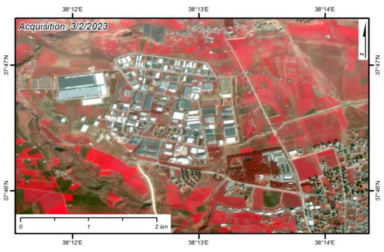
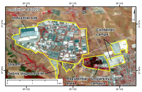
Figure 12.
Pseudocolor image maps in the Adiyaman disposal site area before (first map, acquisition on 3 February 2023) and after (second map, acquisition on 8 June 2023) the initiation of the debris removal from the earthquake-affected area.
Immediately east of the site, 30 high-rise residential buildings have been constructed in an area of 0.04 km2 and a perimeter of approximately 1 km (Figure 12). Further to the east, at a distance of 2 km from the site, the main residential area of Adiyaman begins (Figure 12), while in the wider area to the south of the site, mainly farmland is developed. The debris had been deposited within the agricultural land (Figure 12). A local stream which originates from the northwest runs through the disposal site (Figure 12). Almost parallel to the stream, a canal has been constructed apparently for irrigation purposes to the surrounding land and crops (Figure 12).
During our field survey in Adiyaman in early April 2023, the site was fully operational. The arrival of trucks loaded with debris from the earthquake was constant. This was followed by dumping, leveling, and compaction of debris with bulldozers and rollers (Figure 13). No other heavy machinery was observed to separate the materials, nor were there any steel balls separated from the concrete revealing intermediate on-site further treatment of the debris for recycling and reuse. The formation of dust clouds were constant due to the movement of heavy machinery on the debris pile, the leveling and compaction of the pile but mainly due to the unloading of the debris on site (Figure 13). An effective applied measure for the reduction of dust in the surrounding area was that the road leading to the disposal site was constantly wet.
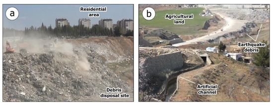
Figure 13.
Characteristic views of the earthquake debris management in Adiyaman disposal site. (a) The formation of dust clouds was constant during debris treatment at the site. The applied protection measures against dust-containing asbestos fibers were limited. (b) The debris disposal site was set up close to water bodies including a stream and an artificial channel.
The above characteristics of the surrounding area and the debris management reveal that the site is not suitable for debris disposal due to its establishment too close to residential areas where a large part of the population lives and works, agricultural land for crops, which were partially covered by debris and surface water bodies (streams and artificial irrigation channels). Furthermore, the constant arrival and departure of trucks and operation of heavy machinery at the debris disposal site without any measure for the reduction of the generated dust severely limit the suitability of this earthquake debris disposal site.
The risks and impacts to public health and to surface water have been mentioned in the previous cases of disposal sites presented so far. The new risk emerging at this site is the impact of the site on surrounding farmland and crops. Soil contamination could be observed due to the hazardous material of the debris such as chemicals, heavy metals, and petroleum products, which can leach into the soil and subsequently reduce the soil quality and fertility. Contaminated soil can have long-term effects on plant growth, disrupt ecosystems, and potentially enter the food chain.
Furthermore, it can lead to increased erosion and further deposition and sedimentation. Debris, if not managed properly, can block drainage routes and increase erosion. In addition, sedimentation and deposition of materials in streams, artificial canals, and other water bodies can harm aquatic life, degrade water quality, and damage ecosystems both upstream and downstream of the site.
Another risk to the natural environment of this area in general and crops, in particular, is the disruption of ecological processes and the impact on sensitive habitats. The introduction of non-native species can lead to the prevalence of new species and disruption of the existing balance with cascading effects on flora, fauna, and even the local population.
5.2.6. Kahramanmaraş Disposal Site
Kahramanmaraş is the second most earthquake-affected province in East Anatolia after Hatay [15,46]. The city is located close to the epicentral area of both earthquakes so the impact of both earthquakes on the building stock was devastating.
Inspections of buildings conducted by the competent authorities in the Kahramanmaraş province found 99,326 buildings collapsed or suffered very heavy structural damage [15], the highest percentage of which occurred in Kahramanmaraş city. This reveals that the need for debris removal from the city was imperative from the very first days of the emergency response. The site that was selected for debris disposal in the wider Kahramanmaraş area is located approximately 5 km from the southeastern edge of the city (Figure 14).
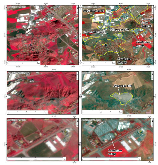
Figure 14.
Pseudocolor image maps in the Kahramanmaraş area before (left column, acquisition on 2 February 2023) and after (right column, acquisition on 11 June 2023) the 6 February 2023 earthquakes. The maps in the third row present the container camp set up at a small distance from the eastern part of the site. Τhe capacity of the camp is approximately 3000 people.
However, there are areas at shorter distances where a large part of the population is active, such as the industrial zone, the suburbs of the city, and the university campus (Figure 14), just as we have seen in the previous case of the Adiyaman city. At a distance of about 1 km to the northeast a densely populated suburb is developed with a perimeter of about 5 km and an area of 1.15 km2 (Figure 14). Even closer, at a distance of less than 300 m to the southwest is the Karakasu settlement with a number of old houses and new high-rise mainly residential buildings (Figure 14). Less than 1 km to the east, a camp with almost 800 (763 in early May 2023) containers for the temporary accommodation of the earthquake-affected people had been set up (Figure 14). If we consider the minimum number of people accommodated in each such structure to be 4, we can understand that more than 3000 people are accommodated in this camp located very close to the debris disposal site. Similarly, the university campus, which also hosts a lot of people, is located at a distance of about 1 km from the disposal site.
During our field survey in early April to this area we found that the site was receiving a large number of trucks depositing debris, and the number of heavy machinery processing the debris at the site was also large (Figure 15). The dumping of debris was occurring at such a rate that the wetting of the debris with water during treatment was not adequate (Figure 15). As a result of these deficiencies in the implementation of preventive measures, dust clouds were created, which not only remained over the site for a long period of time but also spread to surrounding residential areas (Figure 15) including all the above-mentioned facilities for managing the effects of the earthquake disaster.
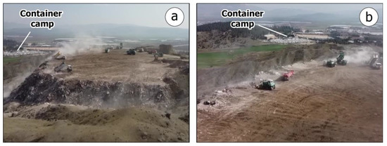
Figure 15.
Characteristic views of the Kahramanmaras disposal site. The formation of dust clouds has the potential to affect not only the workers and volunteers on the site, but also people living in nearby container camps (a,b) for the accommodation of the earthquake-affected and homeless people among other residential areas around the site.
This site, which is one of the largest that have been established in the area, may have an impact on the health of residents, especially of the earthquake-affected people accommodated in the adjacent camp, and the balance of the natural environment. Many of these adverse effects have already been mentioned and analyzed in detail in the previous sections.
6. Discussion
In order to effectively and ideally address the debris impact on public health and the natural environment of the aforementioned sites, it is considered imperative to stop debris treatment, sort the hazardous materials from the debris, store them in other sites with appropriate safe operation standards for the reduction of related risks and the restoration of the landscape. However, in view of the continuation of the debris disposal processes despite the opposition of operational staff, scientists, and the local population, it is proposed that the involved authorities conduct systematic monitoring of environmental parameters and hazardous substances both within the disposal sites and in their surrounding areas and to stop the operations definitively when the recorded values have a high potential to adversely affect the local population and the natural ecosystems, flora, fauna, surface water bodies, and groundwater systems. This monitoring should be continuous until the vulnerable elements of the natural environment are fully restored as the effects can be long-lasting.
A typical example of instrumental monitoring of the effects of debris disposal comes from Algeria and the study by Benmeni and Benrachedi [91] 5 years after the 21 May 2003, Mw = 6.8 earthquake that resulted in 2271 casualties. The study comprised a sampling campaign and subsequent analysis of the leachate from a landfill for earthquake debris disposal and three control wells serving as piezometers in the surrounding area. The results revealed that the concentrations of heavy metals such as Cd, Cl, Zn, and Ni, were above acceptable limits. This inhibited microbial growth and caused organic pollution leading to high chemical oxygen demand (COD) and mineral pollution leading to high concentrations of some additional heavy metals in drainage [91]. Furthermore, the results of the analysis carried out on the groundwater revealed that the first aquifer with a maximum depth of 10 m was already contaminated by leachate outflows making the groundwater reserves non-potable [91]. Furthermore, the significant presence of coliforms and fecal streptococci were attributed mainly to contamination from the infiltration of drainage through cracks in the porous soil [91].
As regards contaminated surface water bodies, groundwater systems, and soils, actions to reuse and recycle debris should be implemented in order to minimize the source of contamination. The benefits of reusing, reducing, and recycling in disaster debris management have been revealed during the application of such approaches after several devastating earthquakes in the past and can be summarized in the reduction of landfill space, raw material demand, and debris management cost [99]. In addition, appropriate treatments for the chemicals and heavy metals that have contaminated soil and water should be implemented to limit their impact and restore water quality and suitability for supply and irrigation purposes as soon as possible [100,101,102,103,104]. In the presence of asbestos, all provisions of the scientific literature and international best practices and procedures for limiting its adverse effects on public health must be strictly applied [105].
No concessions shall be made at any stage of the management of debris from the disaster with regard to the health and safety of workers at the collapse, demolition, and debris disposal sites, volunteers working therein and residents living close to these sites [63]. Best health and safety practices and procedures should be followed to ensure that direct and indirect impacts on all involved in debris management are minimized or eliminated.
The incorporation of the lessons learned from the earthquake debris management in the earthquake-affected area of East Anatolia into the decision-making processes can help policymakers and stakeholders work towards enhancing seismic resilience in several ways leading to the reduction of the impact of earthquakes and ensuring efficient debris management in the aftermath of such devastating events. The areas where the lessons learned from debris management in Anatolia can make an effective contribution include, in particular, preparedness and planning, public awareness and education, debris management strategies, collaborative approaches, robust infrastructure design, as well as evaluation and continuous improvement of the earthquake debris management strategies, policies, and practices.
The correct and incorrect responses in selecting and operating earthquake debris disposal sites in southeastern Turkey after the February 2023 earthquakes can highlight the importance of related preparedness and planning for debris management. Decision-makers can prioritize developing comprehensive disaster management plans that include strategies for efficient debris removal, treatment, and disposal. This can comprise establishing and adopting new guidelines and partnerships with relevant stakeholders, as well as allocating means and resources for debris management.
The lessons learned from the earthquake debris management in East Anatolia can highlight the importance of actions for raising awareness and educating the public. The authorities involved in earthquake disaster management, particularly in earthquake debris management can prioritize public awareness-raising actions to educate communities about the importance of proper debris management including debris reduction, reusing, and recycling. Thus, they can promote active, safe, and effective participation and cooperation of the population in the earthquake-affected areas during the debris removal, treatment, and disposal phases.
Furthermore, the authorities involved in earthquake debris management can work effectively towards the development, adoption, and implementation of integrated management systems capable of removing, treating, and disposing of large volumes of debris produced by destructive earthquakes. This may be accomplished through forming partnerships with debris management organizations and fostering collaboration and coordination among stakeholders including also local communities, non-governmental organizations, and private sector entities. Making investments in alternatives of debris management including recycling, reusing, incineration, composting, mechanical separation, and biological remediation among others, and advocating for environmentally friendly waste management techniques and related facilities could also contribute to maximizing efficiency through establishing communication networks, prearranged agreements, and coordinated response plans to streamline debris management activities.
From the immediate collapses, the subsequent demolitions, and the produced earthquake debris in southeastern Turkey, several vulnerabilities and weaknesses in the seismic performance of existing structures and infrastructures also emerged. This emergence may lead to improvements in designing more resilient practices, materials, and codes in the construction of buildings and infrastructure systems and subsequently in debris generation.
All lessons learned from earthquake debris management in southeastern Turkey, including not only the correct but mainly the incorrect responses in removing, treating, and disposing of debris offer valuable feedback for decision-makers and stakeholders in evaluating the effectiveness of the existing and applied debris management plans and in pointing out areas that need improvement. The continuous improvement of the disaster prevention and management plans, including debris management strategies among others, can enhance the overall resilience of communities to future seismic events.
A limitation of this research has to do with the total number of earthquake debris disposal sites in earthquake-affected southeastern Turkey as well as the number of sites we have analyzed and presented in this research and their representativeness. The fact that tens of debris disposal sites had been established in the Hatay province alone, in the southwestern part of the earthquake-affected region, reveals that the number of sites presented herein can be considered small and not representative at a first approximation. However, the fact that these are sites established close to or within the largest urban centers with the greatest impact on buildings and infrastructure not only in their provinces but throughout affected southeastern Turkey makes these sites among the most typical cases and one of the most representative examples of the approach applied to debris management in southeastern Turkey after the devastating earthquakes.
A suggestion for future research is the application of methods to monitor environmental parameters at the debris disposal sites and their surrounding areas. In the disposal sites presented in this research, incorrect response was detected in debris management, characterized by a high potential to cause serious health impacts on the local population and those involved in debris management as well as to disturb the environmental balance with further direct or indirect implications and impacts on public health. The monitoring of the related environmental parameters in the future could expand on the findings of the current study.
7. Conclusions
Following the deadliest earthquakes in its recent history, Turkey must dispose of hundreds of millions of tonnes of collapse and demolition debris, which is considered the largest of all disasters induced by natural hazards since the 1994 Northridge earthquake, a period for which qualitative and quantitative characteristics of earthquake-induced debris are available. The presence of hazardous materials in this debris made its management a challenge for the agencies involved in managing the impact of the disaster and the need for large debris disposal sites was immediate and imperative.
The present study provided debris management details acquired during post-event field surveys conducted by the authors in the earthquake-affected area. During these field surveys, several debris disposal sites were detected near major urban centers, such as in Antakya and Samandağ in the southern part, Nurdağı and Kahramanmaraş in the central part and Gölbaşı and Adiyaman in the northern and northeastern part of the earthquake affected area respectively, whose common feature was extensive building collapses. Based on observations on the properties of the sites and their surrounding areas as well as on the debris management activities obtained in situ and using satellite imagery, it is concluded that the vast majority of the analyzed sites had characteristics that did not allow them to be classified as properly selected and safe sites for treatment and disposal of earthquake debris. Thus, the management of debris on these sites comprises hazards with a high potential to cause adverse effects on the safety of public health and the balance of the natural environment. The inadequacy of these disposal sites is attributed to several reasons, the most important of which is the proximity to (Table 3):
Table 3.
Disadvantages of earthquake debris disposal sites in terms of location and proximity to residential areas and vulnerable elements of the natural environment and application of measures for preventing the formation of dust clouds during debris management based on the presented field data.
- residential areas, for example in settlements and towns where a large part of the population lived and worked,
- earthquake camps with thousands of earthquake-affected people temporarily accommodated in container-type structures and tents,
- university campuses where educational staff and students lived, and
- large and small industrial areas where many people work.
As regards the natural environment, these sites were operating within or close to surface water bodies with a high potential for contamination not only of the surface water but also the groundwater systems, with probable subsequent impacts on natural ecosystems and the local population. Most of them are located at a short distance from (Table 3):
- perennial and intermittent streams,
- lakes and lakefront areas,
- marshy areas located in coastal areas, and
- the sea.
From field observations in the disposal sites, it was found that, apart from a few exceptions, the majority of workers and volunteers involved in debris management at collapse, demolition, and disposal sites did not apply the prescribed protection measures against hazardous materials. Few wore dust masks and even fewer wore disposable or replacement clothing. Dust generation in these sites was continuous during the loading, unloading, and sorting of debris. The wetting of the sites and sections of the road network through which debris was transported to the sites was limited (Table 3). In addition, no measures were taken to prevent the generation of dust during transport, such as wetting roads or covering debris on truck beds.
The inadequacy of the disposal sites in terms of their selection criteria and safe operating standards, as well as the failure to follow international practices and lessons learned in disaster debris management, reveals a rush for rapid debris removal and restoration resulting in serious omissions and errors in the preparation of emergency plans for disaster management and concessions in their implementation.
Instead of waiting until a disaster occurs, every society should have a concrete and operational disaster preparedness plan compiled by lawmakers, operational staff, and scientists in cooperation with society. Furthermore, national, regional, and local authorities should give priority to planning for systematic recovery and reconstruction from any disaster rather than distracting attention from them. When they finally occur, the time for planning will be limited or non-existent, and generally, the disaster effects will be severe and long-lasting resulting also in a very long recovery and reconstruction period beyond any prediction. If the involved authorities are well prepared by applying all the lessons learned and good practices from recent disasters, public health, and safety as well as the balance of natural ecosystems will be ensured.
Author Contributions
Conceptualization, S.M. and M.M.; methodology, S.M., M.M. and E.V.; software, S.M. and E.V.; validation, S.M.; formal analysis, S.M., M.M. and E.V.; investigation, S.M., M.M., E.V., I.A., E.L. and P.C.; resources, E.L.; data curation, S.M. and M.M.; writing—original draft preparation, S.M., M.M. and E.V.; writing—review and editing, S.M. and M.M.; visualization, S.M. and E.V.; supervision, S.M.; project administration, E.L.; funding acquisition, E.L. All authors have read and agreed to the published version of the manuscript.
Funding
This research received no external funding.
Institutional Review Board Statement
Not applicable.
Informed Consent Statement
Not applicable.
Data Availability Statement
Data is contained within the article.
Acknowledgments
We would like to thank the Assistant Editor and tree reviewers for their constructive comments that contributed to improve the clarity, the scientific soundness and the overall merit of this manuscript.
Conflicts of Interest
The authors declare no conflict of interest.
References
- Brown, C.; Milke, M.; Seville, E. Disaster waste management: A review article. Waste Manag. 2011, 31, 1085–1098. [Google Scholar] [CrossRef]
- Brown, C. Waste Management Following Earthquake Disaster. In Encyclopedia of Earthquake Engineering; Beer, M., Kougioumtzoglou, I., Patelli, E., Au, I.K., Eds.; Springer: Berlin/Heidelberg, Germany, 2014; pp. 1–16. [Google Scholar] [CrossRef]
- Dugar, N.; Karanjit, S.; Khatiwada, N.R.; Shakya, S.M.; Ghimire, A. Post-disaster Waste Management: Lessons Learnt from 2015 Nepal Earthquake. In Sustainable Waste Management: Policies and Case Studies; Ghosh, S.K., Ed.; Springer Nature Singapore Private Limited: Singapore, 2017; pp. 465–483. [Google Scholar] [CrossRef]
- Xiao, J.; Xie, H.; Zhang, C. Investigation on building waste and reclaim in Wenchuan earthquake disaster area. Resour. Conserv. Recycl. 2012, 61, 109–117. [Google Scholar] [CrossRef]
- Baycan, F. Emergency planning for disaster waste: A proposal based on the experience of the Marmara earthquake in Turkey. In Proceedings of the 2004 International Conference and Student Competition on Post-Disaster Reconstruction: Planning for Reconstruction, Coventry, UK, 22–23 April 2004; pp. 1361–1375. [Google Scholar]
- Johnston, D.; Dolan, L.; Saunders, W.; van Schalkwyk, R.; Killeen, C.; Cousins, J.; Glavovic, B.; Brown, C.; McIntyre, I. Disposal of Debris Following Urban Earthquakes: Guiding the Development of Comprehensive Pre-Event Plans. Institute of Geological and Nuclear Sciences Limited, GNS Science Report 2009/33; 30p, 2009. Available online: https://www.eqc.govt.nz/assets/Publications-Resources/2335-Disposal-of-debris-following-urban-earthquakes.pdf (accessed on 15 April 2023).
- Jang, Y.-C.; Townsend, T.G. Occurrence of organic pollutants in recovered soil fines from construction and demolition waste. Waste Manag. 2001, 21, 703–715. [Google Scholar] [CrossRef]
- Jang, Y.-C.; Townsend, T. Sulfate leaching from recovered construction and demolition debris fines. Adv. Environ. Res. 2001, 5, 203–217. [Google Scholar] [CrossRef]
- United States Geological Survey (USGS). M 7.8—Pazarcik Earthquake, Kahramanmaras Earthquake Sequence. Available online: https://earthquake.usgs.gov/earthquakes/eventpage/us6000jllz/executive (accessed on 15 April 2023).
- United States Geological Survey (USGS). M 7.5—Elbistan Earthquake, Kahramanmaras Earthquake Sequence. Available online: https://earthquake.usgs.gov/earthquakes/eventpage/us6000jlqa/executive (accessed on 15 April 2023).
- Mai, P.M.; Aspiotis, T.; Aquib, T.A.; Cano, E.V.; Castro-Cruz, D.; Espindola-Carmona, A.; Li, B.; Li, X.; Liu, J.; Matrau, R.; et al. The Destructive Earthquake Doublet of 6 February 2023 in South-Central Türkiye and Northwestern Syria: Initial Observations and Analyses. Seism. Rec. 2023, 3, 105–115. [Google Scholar] [CrossRef]
- Lekkas, E.; Carydis, P.; Vassilakis, E.; Mavroulis, S.; Argyropoulos, I.; Sarantopoulou, A.; Mavrouli, M.; Konsolaki, A.; Gogou, M.; Katsetsiadou, K.-N.; et al. The 6 February 2023 Turkey-Syria Earthquakes. Newsl. Environ. Disaster Cris. Manag. Strateg. 2023, 29, 1–202. [Google Scholar] [CrossRef]
- Taftsoglou, M.; Valkaniotis, S.; Karantanellis, E.; Goula, E.; Papathanassiou, G. Preliminary Mapping of Liquefaction Phenomena Triggered by the February 6 2023 M7.7 Earthquake, Türkiye/Syria, Based on Remote Sensing Data. Zenodo. 23 February 2023. Available online: https://zenodo.org/record/7668401 (accessed on 25 April 2023).
- Çetin, K.Ö.; Ilgaç, M.; Can, G.; Çakır, E. Preliminary Reconnaissance Report on February 6, 2023, Pazarcık Mw = 7.7 and Elbistan Mw = 7.6, Kahramanmaraş-Türkiye Earthquakes. Middle East Technical University, Earthquake Engineering Research Center, Report No: METU/EERC 2023-01, Ankara, Turkey. 2023. Available online: https://eerc.metu.edu.tr/en/system/files/documents/DMAM_Report_2023_Kahramanmaras-Pazarcik_and_Elbistan_Earthquakes_Report_final_ENG.pdf (accessed on 25 April 2023).
- Türkiye Recovery and Reconstruction Assessment (TERRA). Türkiye Earthquakes Recovery and Reconstruction Assessment. Report with the Support of the United Nations and the European Union, with Select Inputs from World Bank Staff. Available online: https://www.sbb.gov.tr/wp-content/uploads/2023/03/Turkiye-Recovery-and-Reconstruction-Assessment.pdf (accessed on 20 April 2023).
- Ministry of Climate Change and Civil Protection. Press Release on 12 February 2023. Available online: https://civilprotection.gov.gr/deltia-tupou/epestrepse-i-elliniki-apostoli-ereynas-kai-diasosis-apo-tin-toyrkia-ta-meli-tis (accessed on 15 April 2023).
- Sliusar, N.; Filkin, T.; Huber-Humer, M.; Ritzkowski, M. Drone technology in municipal solid waste management and landfilling: A comprehensive review. Waste Manag. 2021, 139, 1–16. [Google Scholar] [CrossRef]
- Frazier, A.E.; Hemingway, B.L. A Technical Review of Planet Smallsat Data: Practical Considerations for Processing and Using PlanetScope Imagery. Remote Sens. 2021, 13, 3930. [Google Scholar] [CrossRef]
- Olthof, I.; Svacina, N. Testing Urban Flood Mapping Approaches from Satellite and In-Situ Data Collected during 2017 and 2019 Events in Eastern Canada. Remote Sens. 2020, 12, 3141. [Google Scholar] [CrossRef]
- Ruiz, L.F.C.; Dematte, J.A.M.; Safanelli, J.L.; Rizzo, R.; Silvero, N.E.Q.; Rosin, N.A.; Campos, L.R. Obtaining high-resolution synthetic soil imagery for topsoil mapping. Remote Sens. Lett. 2021, 13, 107–114. [Google Scholar] [CrossRef]
- Lefulebe, B.E.; Van der Walt, A.; Xulu, S. Fine-Scale Classification of Urban Land Use and Land Cover with PlanetScope Im-agery and Machine Learning Strategies in the City of Cape Town, South Africa. Sustainability 2022, 14, 9139. [Google Scholar] [CrossRef]
- Kalafat, D.; Güneş, Y.; Kara, M.; Deniz, P.; Kekovali, K.; Kuleli, H.S.; Gülen, L.; Yilmazer, M.; Özel, N.M. A Revised and Extended Earthquake Catalogue for Turkey since 1900 (M ≥ 4.0); Boğaziçi University, Kandilli Observatory and Earthquake Research Institute: Istanbul, Turkey, 2007. [Google Scholar]
- Şengör, A.; Tüysüz, O.; Imren, C.; Sakınç, M.; Eyidoğan, H.; Görür, N.; Le Pichon, X.; Rangin, C. The North Anatolian Fault: A New Look. Annu. Rev. Earth Planet. Sci. 2005, 33, 37–112. [Google Scholar] [CrossRef]
- Duman, T.Y.; Emre, Ö. The East Anatolian Fault: Geometry, segmentation and jog characteristics. Geol. Soc. Lond. Spec. Publ. 2013, 372, 495–529. [Google Scholar] [CrossRef]
- Lekkas, E.; Carydis, P.; Mavroulis, S. The January 24, 2020 Mw 6.8 Elazig (Turkey) Earthquake. Newsl. Environ. Disaster Cris. Manag. Strateg. 2020, 16, 1–84. [Google Scholar] [CrossRef]
- Bayrak, E.; Ozer, C. The 24 January 2020 (Mw 6.8) Sivrice (Elazig, Turkey) earthquake: A first look at spatiotemporal distribution and triggering of aftershocks. Arab. J. Geosci. 2021, 14, 2445. [Google Scholar] [CrossRef]
- Papadimitriou, P.; Kapetanidis, V.; Karakonstantis, A.; Spingos, I.; Kassaras, I.; Sakkas, V.; Kouskouna, V.; Karatzetzou, A.; Pavlou, K.; Kaviris, G.; et al. First Results on the Mw = 6.9 Samos Earthquake of 30 October 2020. Bull. Geol. Soc. Greece 2020, 56, 251–279. [Google Scholar] [CrossRef]
- Çetin, K.Ö.; Mylonakis, G.; Sextos, A.; Stewart, J.P. Seismological and Engineering Effects of the M 7.0 Samos Island (Aegean Sea) Earthquake; Report GEER-069; Geotechnical Extreme Events Reconnaissance Association: Alameda County, CA, USA, 2021. [Google Scholar] [CrossRef]
- Mavroulis, S.; Triantafyllou, I.; Karavias, A.; Gogou, M.; Katsetsiadou, K.-N.; Lekkas, E.; Papadopoulos, G.A.; Parcharidis, I. Primary and Secondary Environmental Effects Triggered by the 30 October 2020, Mw = 7.0, Samos (Eastern Aegean Sea, Greece) Earthquake Based on Post-Event Field Surveys and InSAR Analysis. Appl. Sci. 2021, 11, 3281. [Google Scholar] [CrossRef]
- Triantafyllou, I.; Gogou, M.; Mavroulis, S.; Lekkas, E.; Papadopoulos, G.A.; Thravalos, M. The Tsunami Caused by the 30 October 2020 Samos (Aegean Sea) Mw7.0 Earthquake: Hydrodynamic Features, Source Properties and Impact Assessment from Post-Event Field Survey and Video Records. J. Mar. Sci. Eng. 2021, 9, 68. [Google Scholar] [CrossRef]
- Ertürk, E.; Aykanat, B.; Altunışık, A.C.; Arslan, M.E. Seismic damage assessment based on site observation following the Düzce (Gölyaka) earthquake (Mw = 5.9, November 23, 2022). J. Struct. Eng. Appl. Mech. 2022, 5, 197–221. [Google Scholar] [CrossRef]
- Lekkas, E.L. Parameters of intensity distribution in the Izmit and Dazce (Turkey) earthquakes. Bull. Geol. Soc. Greece 2001, 34, 1515–1521. [Google Scholar] [CrossRef]
- Lekkas, E.L. The 1999 eartquake activity in Izmit, NW Turkey. An opportunity for the study of actualistic strike-slip related tectonic forms. Bull. Geol. Soc. Greece 2001, 34, 1523–1529. [Google Scholar] [CrossRef]
- Barka, A.A.; Kadinsky-Cade, K. Strike-slip fault geometry in Turkey and its influence on earthquake activity. Tectonics 1988, 7, 663–684. [Google Scholar] [CrossRef]
- Taymaz, T.; Eyidoğan, H.; Jackson, J. Source parameters of large earthquakes in the East Anatolian Fault Zone (Turkey). Geophys. J. Int. 1991, 106, 537–550. [Google Scholar] [CrossRef]
- Saroğlu, F.; Emre, Ö.; Kuşçu, İ. The East Anatolian Fault Zone of Turkey. Ann. Tecton. 1992, 6, 99–125. [Google Scholar]
- Ambraseys, N. Earthquakes in the Mediterranean and Middle East, a Multidisciplinary Study of Seismicity up to 1900; Cambridge University Press: Cambridge, UK, 2009; p. 970. [Google Scholar] [CrossRef]
- Taymaz, T.; Ganas, A.; Yolsal-Çevikbilen, S.; Vera, F.; Eken, T.; Erman, C.; Keleş, D.; Kapetanidis, V.; Valkaniotis, S.; Karasante, I.; et al. Source mechanism and rupture process of the 24 January 2020 Mw 6.7 Doğanyol-Sivrice earthquake obtained from seismological waveform analysis and space geodetic observations on the East Anatolian Fault Zone (Turkey). Tectonophysics 2021, 804, 228745. [Google Scholar] [CrossRef]
- Lekkas, E.; Vassilakis, E. The Adana Earthquake (Turkey)—Seismotectonic Framework, Geodynamic Phenomena, Impact on the Structured Environment. In Proceedings of the 12th World Congress of Earthquake Engineering, Auckland, New Zealand, 30 January–4 February 2000. Paper No. 0480. [Google Scholar]
- Lozios, S.; Lekkas, E.; Danamos, G. The Bingöl, Eastern Turkey, Earthquake. Co-Seismic Phenomena and Damage Distribution. In Proceedings of the 13th World Conference on Earthquake Engineering, Vancouver, BC, Canada, 1–6 August 2004. Paper No. 3010. [Google Scholar]
- Tan, O.; Pabuçcu, Z.; Tapırdamaz, M.C.; İnan, S.; Ergintav, S.; Eyidoğan, H.; Aksoy, E.; Kuluöztürk, F. Aftershock study and seismotectonic implications of the 8 March 2010 Kovancılar (Elazığ, Turkey) earthquake (MW= 6.1). Geophys. Res. Lett. 2011, 38, L11304. [Google Scholar] [CrossRef]
- Carydis, P.; Lekkas, E.; Papaioannou, C.; Tsokos, A.; Delakouridis, J. The October 23 (Mw = 7.2) and November 9 (Mw = 5.7), 2011 Van, Turkey earthquakes. A geoscientific and engineering report. Ingegneria Sismica 2012, 29, 13–36. [Google Scholar]
- Melgar, D.; Taymaz, T.; Ganas, A.; Crowell, B.; Öcalan, T.; Kahraman, M.; Tsironi, V.; Yolsal-Çevikbilen, S.; Valkaniotis, S.; Irmak, T.S.; et al. Sub- and super-shear ruptures during the 2023 Mw 7.8 and Mw 7.6 earthquake doublet in SE Türkiye. Seismica 2023, 2, 1–10. [Google Scholar] [CrossRef]
- European-Mediterranean Seismological Centre (EMSC). M 7.8—CENTRAL TURKEY—2023-02-06 01:17:36 UTC. Available online: https://www.emsc-csem.org/Earthquake/earthquake.php?id=1218444#summary (accessed on 3 April 2023).
- Görüm, T.; Tanyaş, H. Less than expected? Landslides triggered by the 2023 Mw 7.7 and 7.6 Kahramanmaras (Türkiye) earthquake sequence. In Proceedings of the EGU General Assembly 2023, EGU23-17606, Vienna, Austria, 24–28 April 2023. [Google Scholar] [CrossRef]
- Global Facility for Disaster Reduction and Recovery and World Bank Group. Global Rapid Post-Disaster Damage Estimation (GRADE) Report. February 6, 2023 Kahramanmaraş Earthquakes. Türkiye Report. International Bank for Reconstruction and Development/The World Bank, Washington DC, USA. 2023. Available online: http://documents1.worldbank.org/curated/en/099022723021250141/pdf/P1788430aeb62f08009b2302bd4074030fb.pdf (accessed on 20 April 2023).
- Mercimek, Ö. Seismic failure modes of masonry structures exposed to Kahramanmaraş earthquakes (Mw 7.7 and 7.6) on February 6, 2023. Eng. Fail. Anal. 2023, 151, 107422. [Google Scholar] [CrossRef]
- Işık, E.; Avcil, F.; Büyüksaraç, A.; İzol, R.; Arslan, M.H.; Aksoylu, C.; Harirchian, E.; Eyisüren, O.; Arkan, E.; Güngür, M.; et al. Structural damages in masonry buildings in Adıyaman during the Kahramanmaraş (Turkiye) earthquakes (Mw 7.7 and Mw 7.6) on 06 February 2023. Eng. Fail. Anal. 2023, 151, 107405. [Google Scholar] [CrossRef]
- Grünthal, G. (Ed.) European Macroseismic Scale 1998 EMS-98; Conseil de l’Europe, Cahiers du Centre Européen de Géodynamique et de Séismologie: Luxembourg, 1998; Volume 15. [Google Scholar]
- Qu, Z.; Wang, F.; Chen, X.; Wang, X.; Zhou, Z. Rapid report of seismic damage to hospitals in the 2023 Turkey earthquake sequences. Earthq. Res. Adv. 2023, 100234. [Google Scholar] [CrossRef]
- Kocaman, I. The effect of the Kahramanmaraş earthquakes (Mw 7.7 and Mw 7.6) on historical masonry mosques and minarets. Eng. Fail. Anal. 2023, 149, 107225. [Google Scholar] [CrossRef]
- United Nations Development Programme (UNDP). Millions of Tons of Earthquake Rubble Await Removal in Türkiye. Available online: https://www.undp.org/turkiye/press-releases/millions-tons-earthquake-rubble-await-removal-turkiye (accessed on 10 April 2023).
- Xiao, J.; Deng, Q.; Hou, M.; Shen, J.; Gencel, O. Where are demolition wastes going: Reflection and analysis of the February 6, 2023 earthquake disaster in Turkey. Low-Carbon Mater. Green Constr. 2023, 1, 17. [Google Scholar] [CrossRef]
- Centre for Research on the Epidemiology of Disasters (CRED). EM-DAT—The International Disaster Database. Available online: https://public.emdat.be/ (accessed on 15 April 2023).
- United States Environmental Protection Agency (1995). Planning for Disaster Debris. Report, December 1995. Available online: https://archive.epa.gov/epawaste/inforesources/web/pdf/dstr-pdf.pdf (accessed on 12 March 2023).
- Hirayama, N.; Kawata, Y.; Suzuki, S.; Harada, K. Estimation procedure for potential quantity of tsunami debris on tsunami earthquake disasters. In Proceedings of the Sardinia 2009 12th International Waste Management and Landfill Symposium, S. Margherita di Pula, Cagliari, Italy, 5–9 October 2009. [Google Scholar]
- Sakai, S.; Poudel, R.; Asari, M.; Kirikawa, T. Disaster waste management after the 2016 Kumamoto Earthquake: A mini-review of earthquake waste management and the Kumamoto experience. Waste Manag. Res. 2018, 37, 247–260. [Google Scholar] [CrossRef]
- United Nations Office for the Coordination of Humanitarian Affairs (UNOCHA). Disaster Waste Management Guidelines (Vol. January 2011). Emergency Preparedness Section, Joint UNEP/OCHA Environment Unit, Geneva. Available online: https://www.unocha.org/sites/unocha/files/DWMG.pdf (accessed on 25 April 2023).
- Di Coma, C. Procedure e Strumenti per la Gestione delle Macerie da Crolli e Demolizioni e da Interventi di Ristrutturazione Immobiliare; Direzione di Comando e Controllo funzione tutela ambientale, Il Capo del Dipartimento della Protezione Civile: Abruzzo, Italy, 2010.
- Gabrielli, F.; Amato, A.; Balducci, S.; Magi Galluzzi, L.; Beolchini, F. Disaster waste management in Italy: Analysis of recent case studies. Waste Manag. 2018, 71, 542–555. [Google Scholar] [CrossRef]
- Furcas, C.; Balletto, G. Construction and Demolition Debris Management for Sustainable Reconstruction after Disasters: Italian Case Studies. J. Environ. Sci. Eng. B 2012, 1, 865–873. [Google Scholar]
- Booth, W. Haiti Faces Colossal and Costly Cleanup Before it can Rebuild, The Washington Post. Available online: http://www.washingtonpost.com/wp-dyn/content/article/2010/03/06/AR2010030602544.html?hpid=artslot (accessed on 10 April 2023).
- United Nations Environment Programme (2012). Managing Post-Disaster Debris: The Japan Experience. Report of the International Expert Mission to Japan. 56p. Available online: https://wedocs.unep.org/bitstream/handle/20.500.11822/8136/-Managing%20post-disaster%20debris_%20%20the%20Japan%20experience-20121122.pdf?sequence=3&isAllowed=y (accessed on 25 April 2023).
- Brown, C. Disaster Waste Management: A Systems Approach. Ph.D. Thesis, University of Canterbury, Christchurch, New Zeeland, 2012. [Google Scholar]
- Cooper, R.C.; Murchio, J.C. Preliminary Studies of Asbestiform Fibres in Domestic Water Supplies; Aerospace Medical Research Laboratory: Wright-Patterson Air Force Base, OH, USA, 1974. [Google Scholar]
- Kramer, J.; Mudroch, O.; Tihor, S. Asbestos in the Environment; Research Advisory Board, International Joint Commission and Environment: Burlington, ON, Canada, 1974; 50p. [Google Scholar]
- Nicholson, W.J. Analysis of amphibole asbestiform fibres in municipal water supplies. Environ. Health Perspect. 1974, 9, 165–173. [Google Scholar]
- World Health Organization (WHO). Asbestos and Other Natural Mineral Fibres. International Programme on Chemical Safety & World Health Organization. 1986. Available online: https://apps.who.int/iris/bitstream/handle/10665/37190/9241541938-eng.pdf?sequence=1&isAllowed=y (accessed on 15 April 2023).
- Dimiskovska, B. Environmental risks due to debris containing asbestos in post-earthquake conditions. Acta Geod. Geophys. Hung. 2010, 45, 299–306. [Google Scholar] [CrossRef]
- Yashiro, M.; Muso, E.; Itoh, T.; Oyama, A.; Ono, T.; Sasayama, S. Significantly high incidence and high morbidity of acute renal failure with respiratory tract involvement of p-ANCA-related angitis revealed in Kobe city and the environs after the Kobe earthquake in 1995. Clin. Nephrol. 1999, 51, 190–191. [Google Scholar]
- Uchiyama, I. Chronic Health Effects of Inhalation of Dust or Sludge. JMAJ 2013, 56, 91–95. [Google Scholar]
- Świątkowska, B.; Szubert, Z.; Sobala, W.; Szeszenia-Dąbrowska, N. Predictors of lung cancer among former asbestos-exposed workers. Lung Cancer 2015, 89, 243–248. [Google Scholar] [CrossRef]
- Awuchi, C.G.; Ondari, E.N.; Nwozo, S.; Odongo, G.A.; Eseoghene, I.J.; Twinomuhwezi, H.; Ogbonna, C.U.; Upadhyay, A.K.; Adeleye, A.O.; Okpala, C.O.R. Mycotoxins’ Toxicological Mechanisms Involving Humans, Livestock and Their Associated Health Concerns: A Review. Toxins 2022, 14, 167. [Google Scholar] [CrossRef] [PubMed]
- Cooper, P.A. Leaching of CCA: Is it a problem? In Environmental Considerations in the Manufacture, Use and Disposal of Preservative-Treated Wood; Forest Products Society: LaGrange, GA, USA, 1994; pp. 45–57. [Google Scholar]
- Lebow, S.T.; Lebow, P.K.; Foster, D.O.; Brooks, K.M. Environmental Impact of Preservative-Treated Wood in a Wetland Boardwalk; Research paper FPL, RP-582; USDA Forest Service, Forest Products Laboratory: Madison, WI, USA, 2000; 126p.
- Hingston, J.; Collins, C.; Murphy, R.; Lester, J. Leaching of chromated copper arsenate wood preservatives: A review. Environ. Pollut. 2000, 111, 53–66. [Google Scholar] [CrossRef] [PubMed]
- Townsend, T.G.; Sologabriele, H.; Tolaymat, T.; Stook, K. Impact of chromated copper arsenate (CCA) in wood mulch. Sci. Total Environ. 2003, 309, 173–185. [Google Scholar] [CrossRef]
- Townsend, T.; Tolaymat, T.; Sologabriele, H.; Dubey, B.; Stook, K.; Wadanambi, L. Leaching of CCA-treated wood: Implications for waste disposal. J. Hazard. Mater. 2004, 114, 75–91. [Google Scholar] [CrossRef]
- Solo-Gabriele, H.M.; Townsend, T.G.; Hahn, D.W.; Moskal, T.M.; Hosein, N.; Jambeck, J.; Jacobi, G. Evaluation of XRF and LIBS technologies for on-line sorting of CCA-treated wood waste. Waste Manag. 2004, 24, 413–424. [Google Scholar] [CrossRef] [PubMed]
- Solo-Gabriele, H.M.; Townsend, T.G.; Messick, B.; Calitu, V. Characteristics of chromated copper arsenate-treated wood ash. J. Hazard. Mater. 2002, 89, 213–232. [Google Scholar] [CrossRef] [PubMed]
- Iida, K.; Pierman, J.; Tolaymat, T.; Townsend, T.; Wu, C. Control of heavy metal emissions and leaching from incineration of CCA-treated wood using mineral sorbents. J. Environ. Eng. ASCE 2004, 1302, 184–192. [Google Scholar] [CrossRef]
- Ravenscroft, P.; Brammer, H.; Richards, K.S. Arsenic Pollution: A Global Synthesis; RGS-IBG Book Series; Wiley-Blackwell: Chichester, UK; Malden, MA, USA, 2009; ISBN 978-1-4051-8602-5. [Google Scholar]
- Gomez-Caminero, A.; Howe, P.D.; Hughes, M.; Kenyon, E.; Lewis, D.R.; Moore, M.; Aitio, A.; Becking, G.C.; Ng, J. Arsenic and Arsenic Compounds; World Health Organization: Geneva, Switzerland, 2001; Available online: https://apps.who.int/iris/handle/10665/42366 (accessed on 10 April 2023).
- Morrow, P.; Beiter, H.; Amato, F.; Gibb, F. Pulmonary retention of lead: An experimental study in man. Environ. Res. 1980, 21, 373–384. [Google Scholar] [CrossRef]
- Lee, T.-C.; Tanaka, N.; Lamb, P.W.; Gilmer, T.M.; Barrett, J.C. Induction of Gene Amplification by Arsenic. Science 1988, 241, 79–81. [Google Scholar] [CrossRef]
- Puccetti, E.; Ruthardt, M. Acute promyelocytic leukemia: PML/RARα and the leukemic stem cell. Leukemia 2004, 18, 1169–1175. [Google Scholar] [CrossRef][Green Version]
- Waalkes, M.P.; Liu, J.; Ward, J.M.; Diwan, B.A. Mechanisms underlying arsenic carcinogenesis: Hypersensitivity of mice exposed to inorganic arsenic during gestation. Toxicology 2004, 198, 31–38. [Google Scholar] [CrossRef] [PubMed]
- Cox, C. Chromated Copper Arsenate. J. Pestic. Reform. 1991, 11, 2–6. [Google Scholar]
- Wang, Z.; Lin, H.-P.; Li, Y.; Tao, H.; Yang, P.; Xie, J.; Maddy, D.; Kondo, K.; Yang, C. Chronic Hexavalent Chromium Exposure Induces Cancer Stem Cell-Like Property and Tumorigenesis by Increasing c-Myc Expression. Toxicol. Sci. 2019, 172, 252–264. [Google Scholar] [CrossRef] [PubMed]
- Mavrouli, M.; Mavroulis, S.; Lekkas, E.; Tsakris, A. The Impact of Earthquakes on Public Health: A Narrative Review of Infectious Diseases in the Post-Disaster Period Aiming to Disaster Risk Reduction. Microorganisms 2023, 11, 419. [Google Scholar] [CrossRef] [PubMed]
- Benmenni, M.S.; Benrachedi, K. Impact of Earthquake Demolition Debris on the Quality of Groundwater. Am. J. Appl. Sci. 2010, 7, 545–550. [Google Scholar] [CrossRef][Green Version]
- Gotoh, T.; Nishimura, T.; Nakata, M.; Nakaguchi, Y.; Hiraki, K. Air Pollution by Concrete Dust from the Great Hanshin Earthquake. J. Environ. Qual. 2002, 31, 718–723. [Google Scholar] [CrossRef]
- Yalçin-Özdilek, Ş.; Yerlİ, S.V. Green Turtle (Chelonia mydas) Nesting and Habitat Threats at Samandağ Beach, Turkey. Chelonian Conserv. Biol. 2006, 5, 302–305. [Google Scholar] [CrossRef]
- Yalçın-Özdilek, Ş.; Yalçın, S. Wind Energy Plants and Possible Effects on Samandağ Sea Turtles. Mar. Turtle Newsl. 2012, 133, 7–9. [Google Scholar]
- Erol, O.; Pirazzoli, P.A. Seleucia Pieria: An ancient harbour submitted to two successive uplifts. Int. J. Naut. Archaeol. 1992, 21, 317–327. [Google Scholar] [CrossRef]
- Gurkan, A.l.; Salici, A.; Ozyavuz, M. Sustainable land use of coastal areas. Case study of Samandag coastal zone. Oxid. Commun. 2016, 39, 3602–3612. [Google Scholar]
- Genç, C.; Sakalli, A.; Stoyanov, I.; Iliev, T.; Mihaylov, G.; Beloev, I. Wind Energy Potential for Electricity Production in Hatay, Turkey. E3S Web Conf. 2020, 207, 02014. [Google Scholar] [CrossRef]
- Tarı, U.; Tüysüz, O.; Genç, Ş.C.; İmren, C.; Blackwell, B.A.B.; Lom, N.; Tekeşin, Ö.; Üsküplü, S.; Erel, L.; Altıok, S.; et al. The geology and morphology of the Antakya Graben between the Amik Triple Junction and the Cyprus Arc. Geodin. Acta 2013, 26, 27–55. [Google Scholar] [CrossRef]
- Brown, C.; Milke, M. Recycling disaster waste: Feasibility, method and effectiveness. Resour. Conserv. Recycl. 2016, 106, 21–32. [Google Scholar] [CrossRef]
- Selvi, A.; Rajasekar, A.; Theerthagiri, J.; Ananthaselvam, A.; Sathishkumar, K.; Madhavan, J.; Rahman, P.K.S.M. Integrated Remediation Processes Toward Heavy Metal Removal/Recovery from Various Environments—A Review. Front. Environ. Sci. 2019, 7, 66. [Google Scholar] [CrossRef]
- Kumar, M.; Seth, A.; Singh, A.K.; Rajput, M.S.; Sikandar, M. Remediation strategies for heavy metals contaminated ecosystem: A review. Environ. Sustain. Indic. 2021, 12, 100155. [Google Scholar] [CrossRef]
- Wang, Y.; Su, H.; Gu, Y.; Song, X.; Zhao, J. Carcinogenicity of chromium and chemoprevention: A brief update. OncoTargets Ther. 2017, 10, 4065–4079. [Google Scholar] [CrossRef]
- Ahmed, S.F.; Kumar, P.S.; Rozbu, M.R.; Chowdhury, A.T.; Nuzhat, S.; Rafa, N.; Mahlia, T.M.I.; Ong, H.C.; Mofijur, M. Heavy metal toxicity, sources, and remediation techniques for contaminated water and soil. Environ. Technol. Innov. 2021, 25, 102114. [Google Scholar] [CrossRef]
- Alsafran, M.; Saleem, M.H.; Al Jabri, H.; Rizwan, M.; Usman, K. Principles and Applicability of Integrated Remediation Strategies for Heavy Metal Removal/Recovery from Contaminated Environments. J. Plant Growth Regul. 2023, 42, 3419–3440. [Google Scholar] [CrossRef]
- World Health Organization (WHO) (2008). Asbestos—Hazards and Safe Practices for Clean Up after Earthquake. Technical Information Note by the Country Offices of WHO And UNEP In Beijing. 9 June 2008. Available online: https://cdn.who.int/media/docs/default-source/chemical-safety/asbestos/asbestos-after-earthquake.pdf?sfvrsn=1e7e60d_2&download=true (accessed on 15 April 2023).
Disclaimer/Publisher’s Note: The statements, opinions and data contained in all publications are solely those of the individual author(s) and contributor(s) and not of MDPI and/or the editor(s). MDPI and/or the editor(s) disclaim responsibility for any injury to people or property resulting from any ideas, methods, instructions or products referred to in the content. |
© 2023 by the authors. Licensee MDPI, Basel, Switzerland. This article is an open access article distributed under the terms and conditions of the Creative Commons Attribution (CC BY) license (https://creativecommons.org/licenses/by/4.0/).