Vegetation Classification in Urban Areas by Combining UAV-Based NDVI and Thermal Infrared Image
Abstract
1. Introduction
2. Materials and Methods
2.1. Research Process
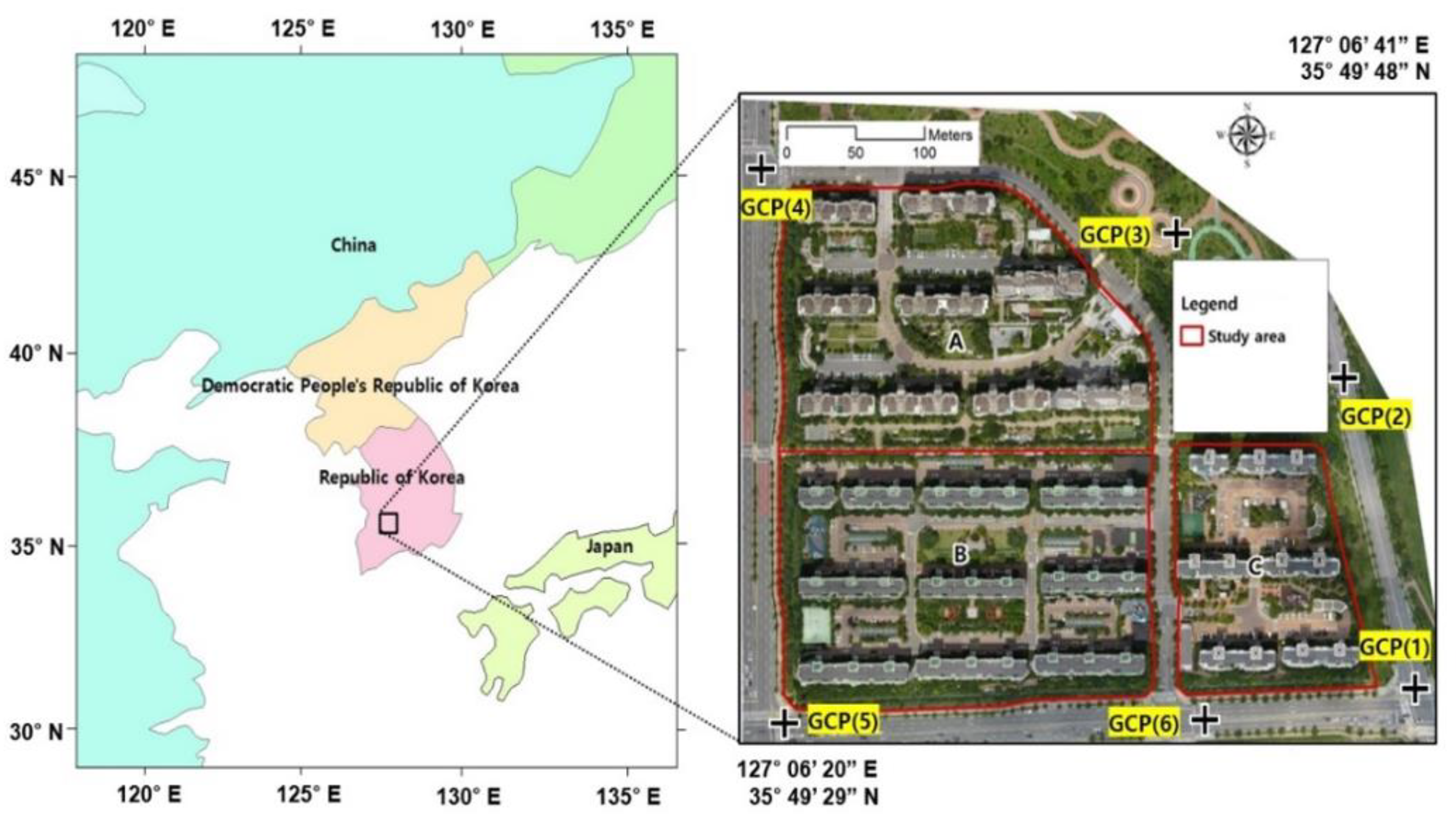
2.2. Study Area
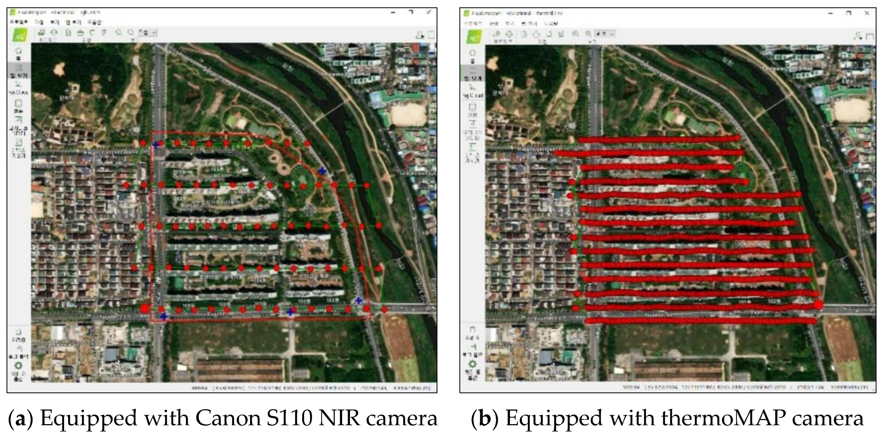
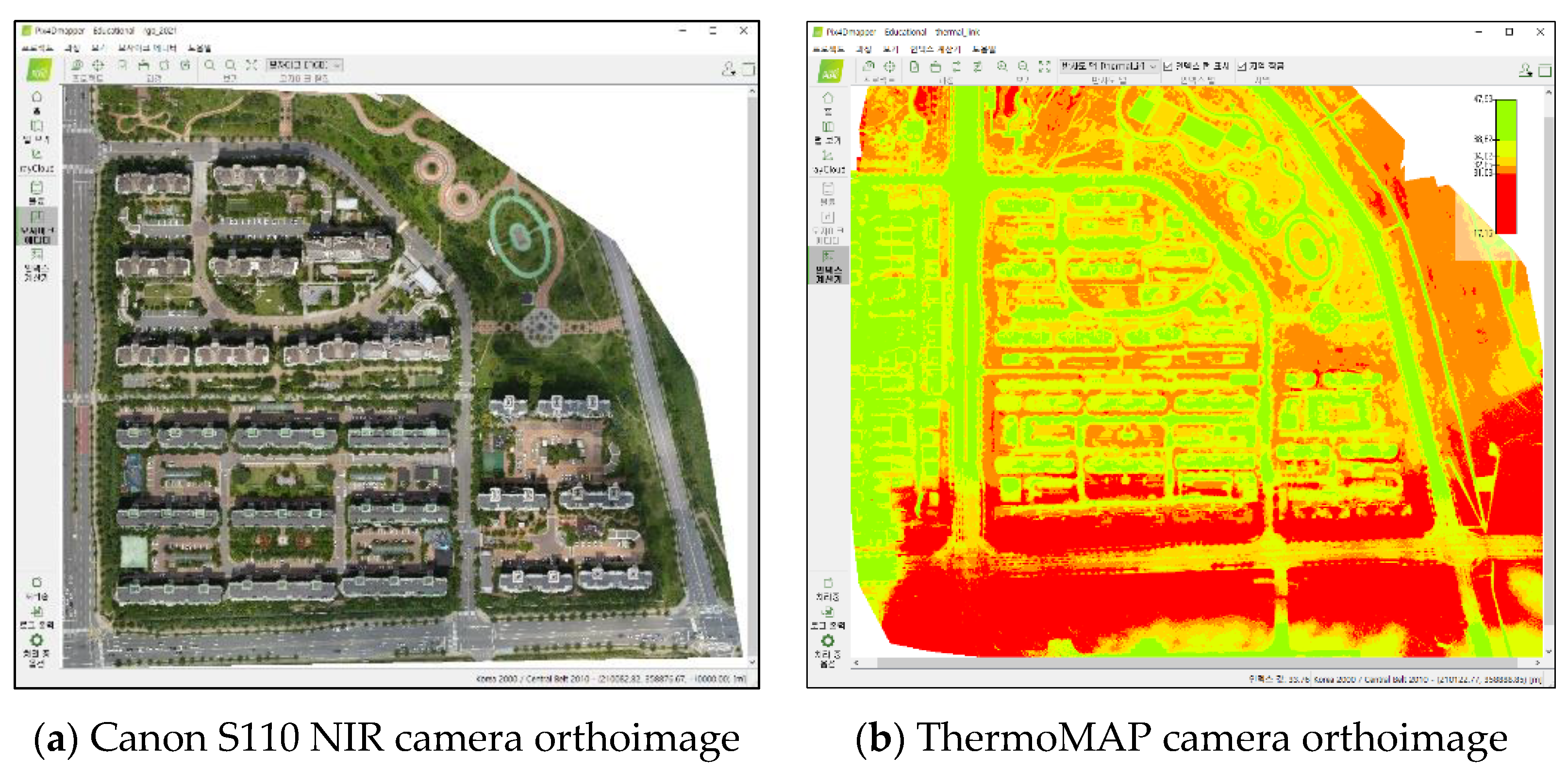
2.3. UAV Image Processing
2.4. Spectroradiometer
3. Result and Discussion
3.1. NDVI Analyzed by UAV-Based Multispectral Image
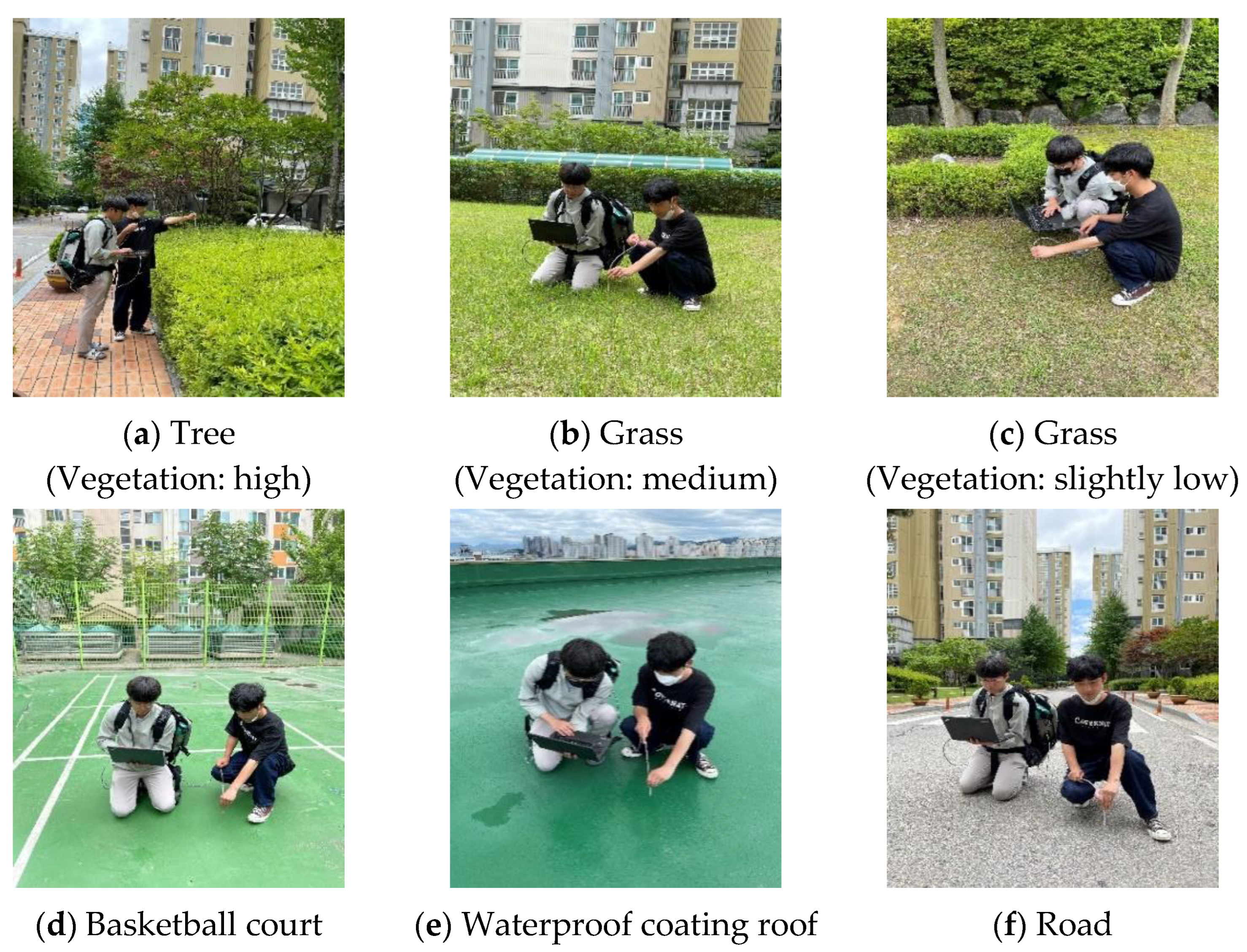
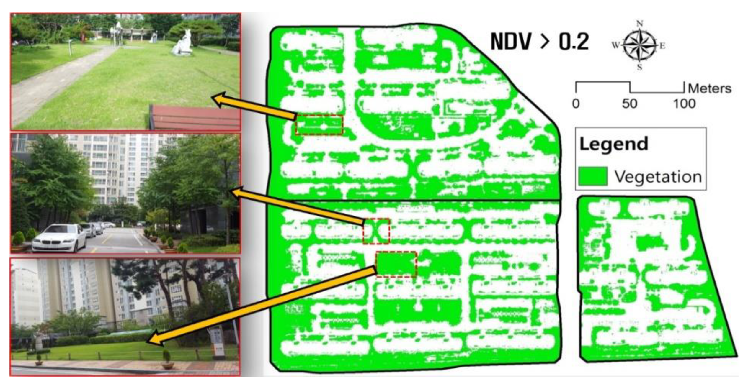
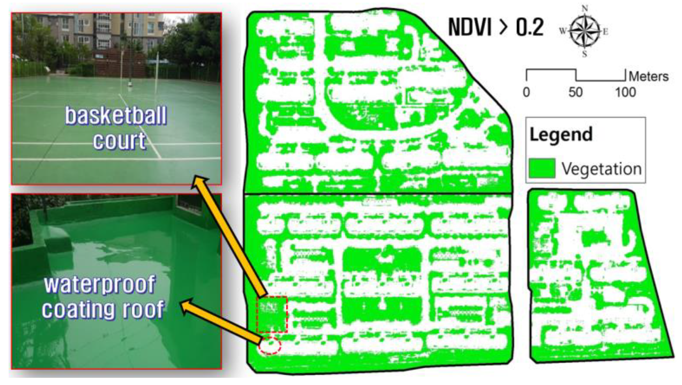
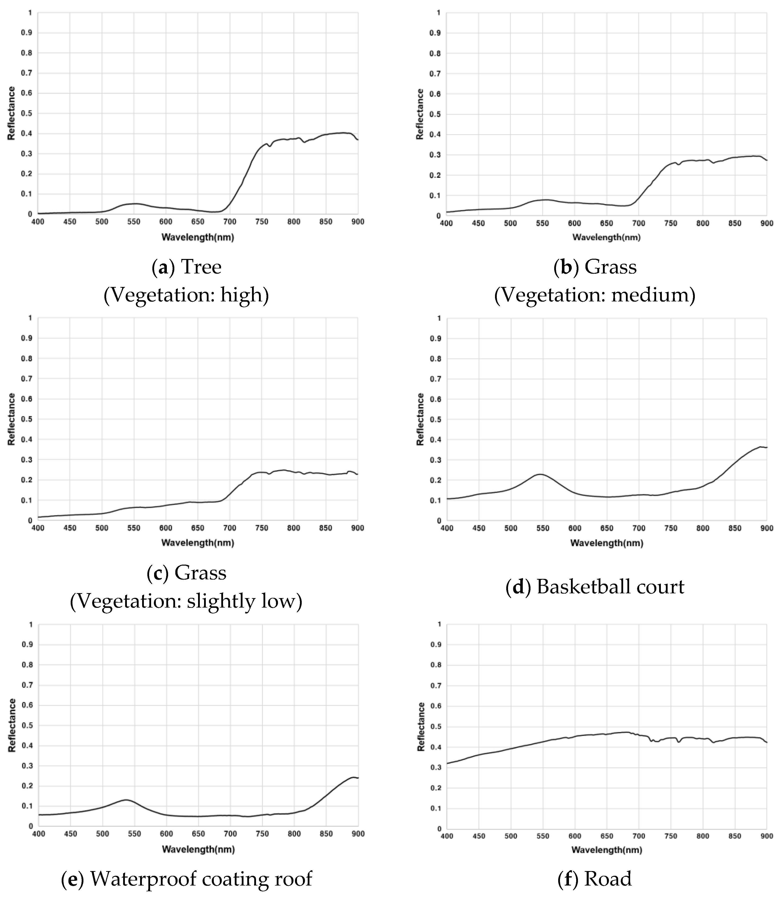
3.2. Spectral Comparison and Vegetation Misclassification Analysis Using a Spectrometer
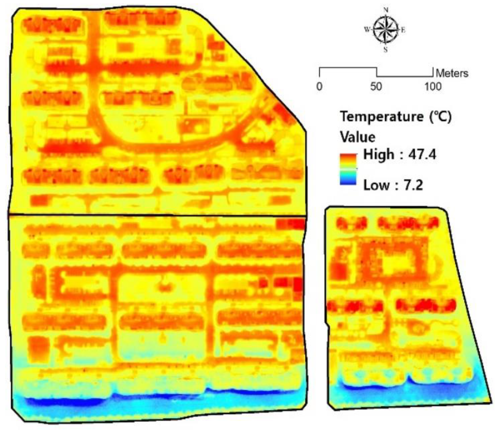
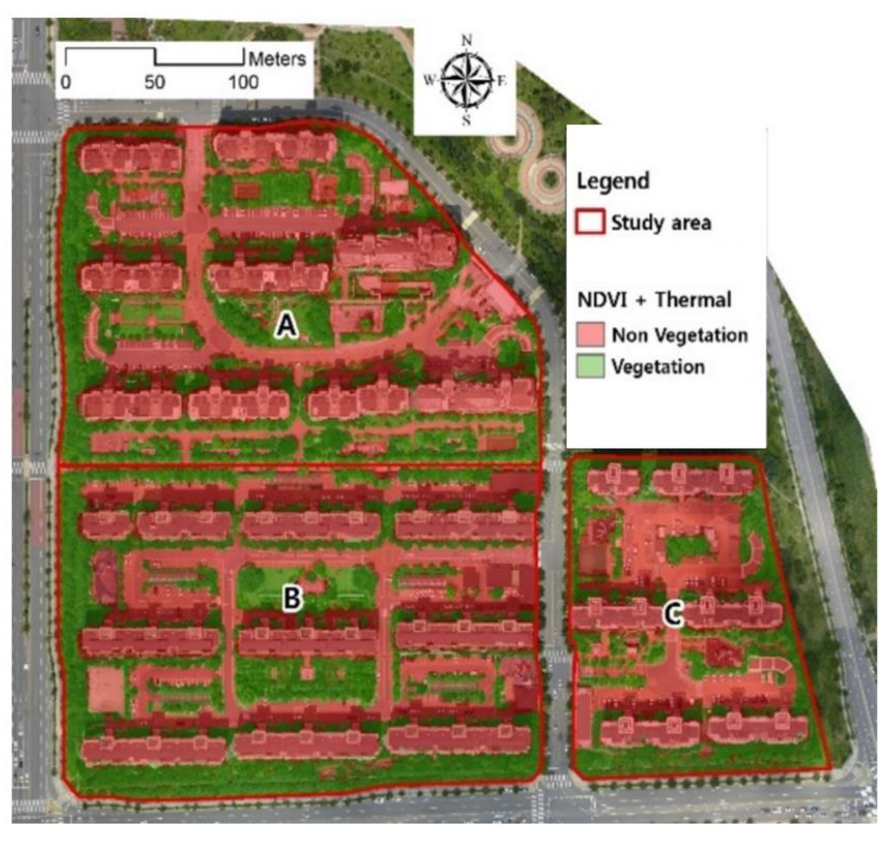
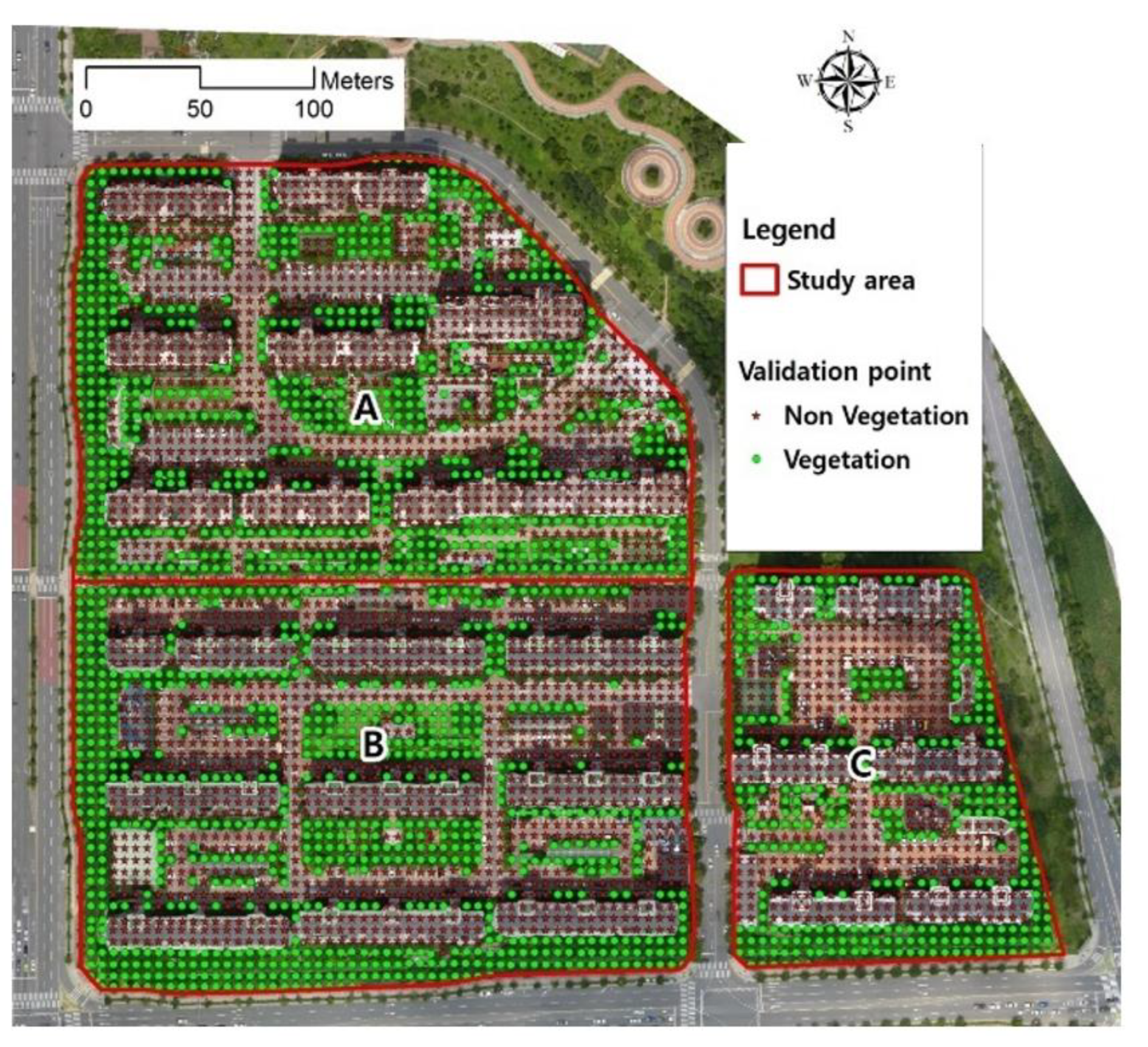
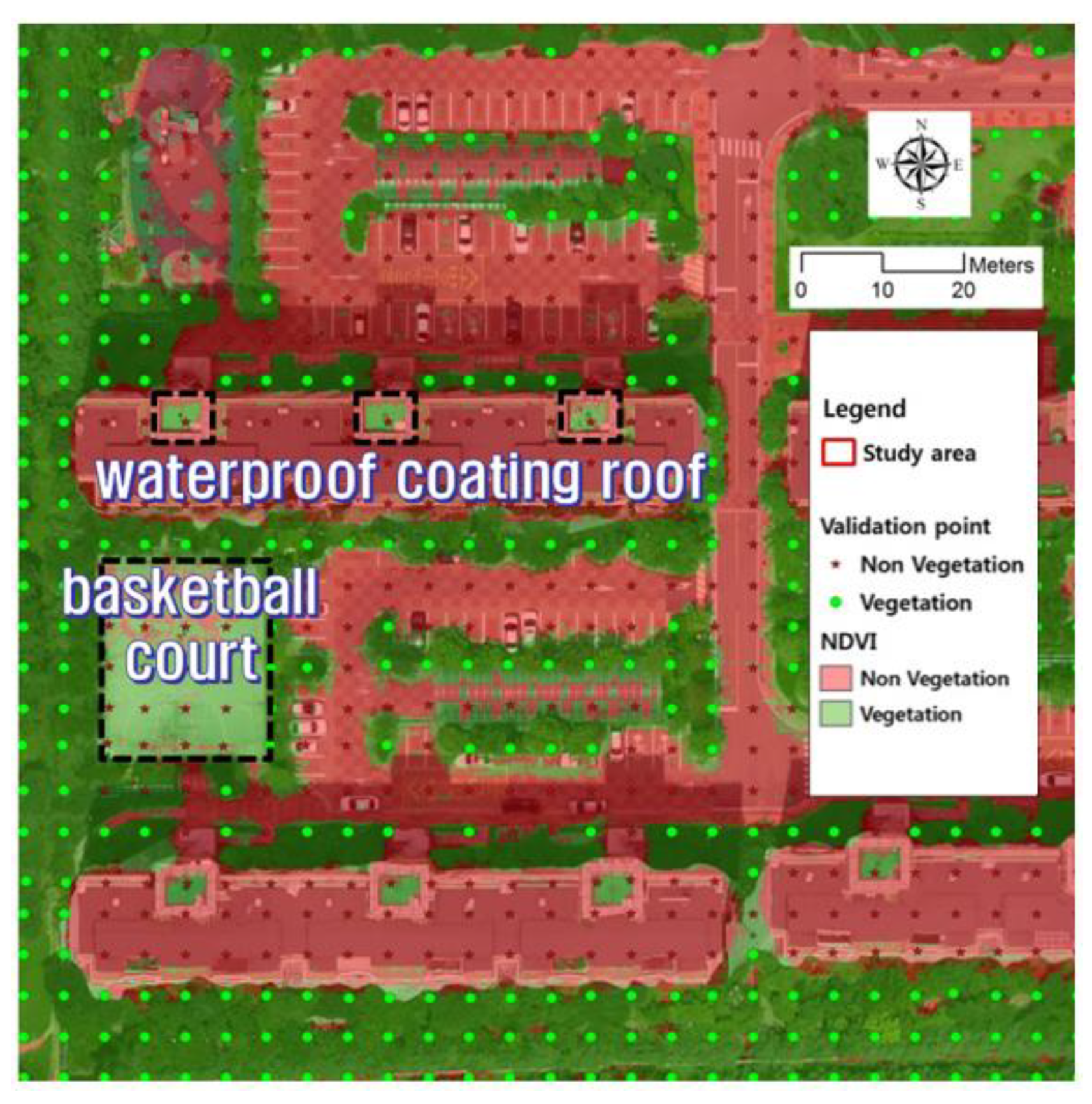
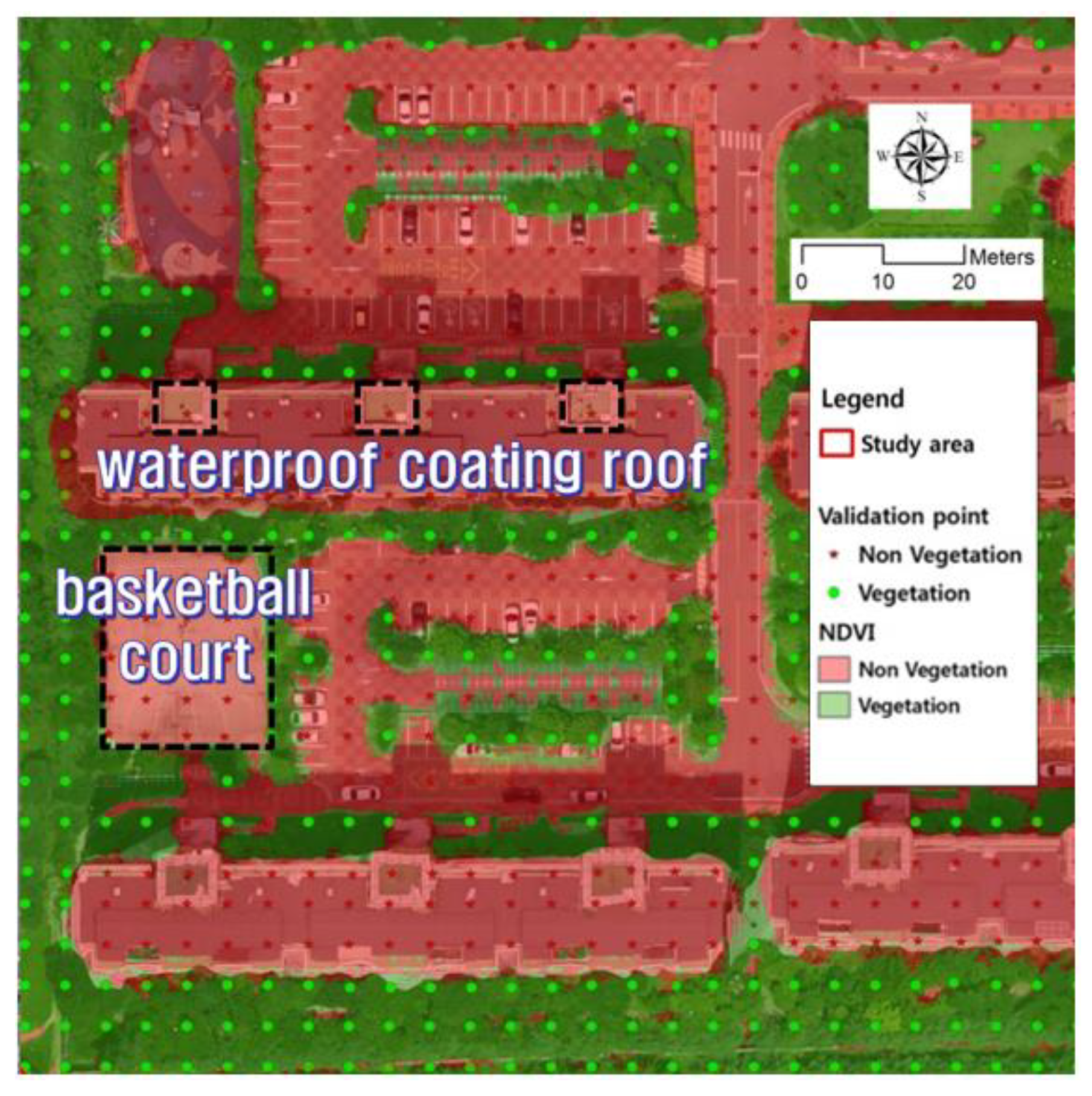
3.3. Vegetation Classification by Combining UAV-Based NDVI and Thermal Infrared Image
4. Conclusions
Author Contributions
Funding
Institutional Review Board Statement
Informed Consent Statement
Data Availability Statement
Conflicts of Interest
References
- Fahad, M.G.R.; Nazari, R.; Bhavsar, P.; Jalayer, M.; Karimi, M. A Decision-Support Framework for Emergency Evacuation Planning during Extreme Storm Events. Transp. Res. D Transp. Env. 2019, 77, 589–605. [Google Scholar] [CrossRef]
- Harrington, L.J.; Ebi, K.L.; Frame, D.J.; Otto, F.E.L. Integrating Attribution with Adaptation for Unprecedented Future Heatwaves. Clim. Change 2022, 172, 2. [Google Scholar] [CrossRef]
- Rousi, E.; Kornhuber, K.; Beobide-Arsuaga, G.; Luo, F.; Coumou, D. Accelerated Western European Heatwave Trends Linked to More-Persistent Double Jets over Eurasia. Nat. Commun. 2022, 13, 3851. [Google Scholar] [CrossRef] [PubMed]
- Sabrin, S.; Karimi, M.; Nazari, R. Developing Vulnerability Index to Quantify Urban Heat Islands Effects Coupled with Air Pollution: A Case Study of Camden, NJ. ISPRS Int. J. Geo-Inf. 2020, 9, 349. [Google Scholar] [CrossRef]
- Uddin, M.N.; Saiful Islam, A.K.M.; Bala, S.K.; Islam, G.M.T.; Adhikary, S.; Saha, D.; Haque, S.; Fahad, M.G.R.; Akter, R. Mapping of Climate Vulnerability of the Coastal Region of Bangladesh Using Principal Component Analysis. Appl. Geogr. 2019, 102, 47–57. [Google Scholar] [CrossRef]
- Park, K. Analysis on the Effects of Land Cover Types and Topographic Features on Heat Wave Days. J. Korean Assoc. Geogr. Inf. Stud. 2016, 19, 76–91. [Google Scholar] [CrossRef]
- Peng, J.; Hu, Y.; Dong, J.; Liu, Q.; Liu, Y. Quantifying Spatial Morphology and Connectivity of Urban Heat Islands in a Megacity: A Radius Approach. Sci. Total Environ. 2020, 714, 136792. [Google Scholar] [CrossRef]
- Sabrin, S.; Karimi, M.; Nazari, R.; Pratt, J.; Bryk, J. Effects of Different Urban-Vegetation Morphology on the Canopy-Level Thermal Comfort and the Cooling Benefits of Shade Trees: Case-Study in Philadelphia. Sustain. Cities Soc. 2021, 66, 102684. [Google Scholar] [CrossRef]
- Voogt, J.A.; Oke, T.R. Thermal Remote Sensing of Urban Climates. Remote Sens. Environ. 2003, 86, 370–384. [Google Scholar] [CrossRef]
- Ziter, C.D.; Pedersen, E.J.; Kucharik, C.J.; Turner, M.G. Scale-Dependent Interactions between Tree Canopy Cover and Impervious Surfaces Reduce Daytime Urban Heat during Summer. Proc. Natl. Acad. Sci. USA 2019, 116, 7575–7580. [Google Scholar] [CrossRef]
- Ellison, D.; Morris, C.E.; Locatelli, B.; Sheil, D.; Cohen, J.; Murdiyarso, D.; Gutierrez, V.; van Noordwijk, M.; Creed, I.F.; Pokorny, J.; et al. Trees, Forests and Water: Cool Insights for a Hot World. Glob. Environ. Change 2017, 43, 51–61. [Google Scholar] [CrossRef]
- Shamsudeen, M.; Padmanaban, R.; Cabral, P.; Morgado, P. Spatio-Temporal Analysis of the Impact of Landscape Changes on Vegetation and Land Surface Temperature over Tamil Nadu. Earth 2022, 3, 614–638. [Google Scholar] [CrossRef]
- Su, Y.; Liu, L.; Wu, J.; Chen, X.; Shang, J.; Ciais, P.; Zhou, G.; Lafortezza, R.; Wang, Y.; Yuan, W.; et al. Quantifying the Biophysical Effects of Forests on Local Air Temperature Using a Novel Three-Layered Land Surface Energy Balance Model. Environ. Int. 2019, 132, 105080. [Google Scholar] [CrossRef] [PubMed]
- Seto, K.C.; Güneralp, B.; Hutyra, L.R. Global Forecasts of Urban Expansion to 2030 and Direct Impacts on Biodiversity and Carbon Pools. Proc. Natl. Acad. Sci. USA 2012, 109, 16083–16088. [Google Scholar] [CrossRef]
- D’Amour, C.B.; Reitsma, F.; Baiocchi, G.; Barthel, S.; Güneralp, B.; Erb, K.H.; Haberl, H.; Creutzig, F.; Seto, K.C. Future Urban Land Expansion and Implications for Global Croplands. Proc. Natl. Acad. Sci. USA 2017, 114, 8939–8944. [Google Scholar] [CrossRef]
- Bojanowski, J.S.; Sikora, S.; Musiał, J.P.; Woźniak, E.; Dąbrowska-Zielińska, K.; Slesiński, P.; Milewski, T.; Łączyński, A. Integration of Sentinel-3 and MODIS Vegetation Indices with ERA-5 Agro-Meteorological Indicators for Operational Crop Yield Forecasting. Remote Sens. 2022, 14, 1238. [Google Scholar] [CrossRef]
- Thomas, J.R.; Gausman, H.W. Leaf Reflectance vs. Leaf Chlorophyll and Carotenoid Concentrations for Eight Crops 1. Agron. J. 1977, 69, 799–802. [Google Scholar] [CrossRef]
- Zhang, F.; Zhang, L.W.; Shi, J.J.; Huang, J.F. Soil Moisture Monitoring Based on Land Surface Temperature-Vegetation Index Space Derived from MODIS Data. Pedosphere 2014, 24, 450–460. [Google Scholar] [CrossRef]
- Jiang, Z.; Huete, A.R.; Chen, J.; Chen, Y.; Li, J.; Yan, G.; Zhang, X. Analysis of NDVI and Scaled Difference Vegetation Index Retrievals of Vegetation Fraction. Remote Sens. Environ. 2006, 101, 366–378. [Google Scholar] [CrossRef]
- Turner, D.P.; Cohen, W.B.; Kennedy, R.E.; Fassnacht, K.S.; Briggs, J.M. Relationships between Leaf Area Index and Landsat TM Spectral Vegetation Indices across Three Temperate Zone Sites. Remote Sens. Environ. 1999, 70, 52–68. [Google Scholar] [CrossRef]
- Schultz, M.; Clevers, J.G.P.W.; Carter, S.; Verbesselt, J.; Avitabile, V.; Quang, H.V.; Herold, M. Performance of Vegetation Indices from Landsat Time Series in Deforestation Monitoring. Int. J. Appl. Earth Obs. Geoinf. 2016, 52, 318–327. [Google Scholar] [CrossRef]
- Roy, D.P.; Kovalskyy, V.; Zhang, H.K.; Vermote, E.F.; Yan, L.; Kumar, S.S.; Egorov, A. Characterization of Landsat-7 to Landsat-8 Reflective Wavelength and Normalized Difference Vegetation Index Continuity. Remote Sens. Environ. 2016, 185, 57–70. [Google Scholar] [CrossRef] [PubMed]
- Liu, J.; Pattey, E.; Jégo, G. Assessment of Vegetation Indices for Regional Crop Green LAI Estimation from Landsat Images over Multiple Growing Seasons. Remote Sens. Environ. 2012, 123, 347–358. [Google Scholar] [CrossRef]
- Jiménez-Jiménez, S.I.; de Marcial-Pablo, M.J.; Ojeda-Bustamante, W.; Sifuentes-Ibarra, E.; Inzunza-Ibarra, M.A.; Sánchez-Cohen, I. VICAL: Global Calculator to Estimate Vegetation Indices for Agricultural Areas with Landsat and Sentinel-2 Data. Agronomy 2022, 12, 1518. [Google Scholar] [CrossRef]
- Hawryło, P.; Bednarz, B.; Wężyk, P.; Szostak, M. Estimating Defoliation of Scots Pine Stands Using Machine Learning Methods and Vegetation Indices of Sentinel-2. Eur. J. Remote Sens. 2018, 51, 194–204. [Google Scholar] [CrossRef]
- Mandal, D.; Kumar, V.; Ratha, D.; Dey, S.; Bhattacharya, A.; Lopez-Sanchez, J.M.; McNairn, H.; Rao, Y.S. Dual Polarimetric Radar Vegetation Index for Crop Growth Monitoring Using Sentinel-1 SAR Data. Remote Sens. Environ. 2020, 247, 111954. [Google Scholar] [CrossRef]
- Hill, M.J. Vegetation Index Suites as Indicators of Vegetation State in Grassland and Savanna: An Analysis with Simulated SENTINEL 2 Data for a North American Transect. Remote Sens. Environ. 2013, 137, 94–111. [Google Scholar] [CrossRef]
- Jia, M.; Wang, Z.; Wang, C.; Mao, D.; Zhang, Y. A New Vegetation Index to Detect Periodically Submerged Mangrove Forest Using Single-Tide Sentinel-2 Imagery. Remote Sens. 2019, 11, 2043. [Google Scholar] [CrossRef]
- Hashemzadeh Ghalhari, M.; Vafakhah, M.; Damavandi, A.A. Agricultural Drought Assessment Using Vegetation Indices Derived from MODIS Time Series in Tehran Province. Arab. J. Geosci. 2022, 15, 412. [Google Scholar] [CrossRef]
- Zeng, Y.; Hao, D.; Huete, A.; Dechant, B.; Berry, J.; Chen, J.M.; Joiner, J.; Frankenberg, C.; Bond-Lamberty, B.; Ryu, Y.; et al. Optical Vegetation Indices for Monitoring Terrestrial Ecosystems Globally. Nat. Rev. Earth Environ. 2022, 3, 477–493. [Google Scholar] [CrossRef]
- Shamloo, N.; Sattari, M.T.; Apaydin, H. Agricultural Drought Survey Using MODIS-Based Image Indices at the Regional Scale: Case Study of the Urmia Lake Basin, Iran. Theor. Appl. Climatol. 2022, 149, 39–51. [Google Scholar] [CrossRef]
- Fensholt, R.; Sandholt, I.; Stisen, S. Evaluating MODIS, MERIS, and VEGETATION Vegetation Indices Using in Situ Measurements in a Semiarid Environment. IEEE Trans. Geosci. Remote Sens. 2006, 44, 1774–1786. [Google Scholar] [CrossRef]
- Huong, N.T.T.; Phuong, L.T. Quantify Forest Stand Volume Using SPOT 5 Satellite Image. In Global Changes and Sustainable Development in Asian Emerging Market Economies; Springer Nature: Berlin/Heidelberg, Germany, 2022; Volume 2. [Google Scholar]
- Rouse, J.W.; Haas, R.H.; Schell, J.A.; Deering, D.W. Monitoring Vegetation Systems in the Great Plains with ERTS. NASA Special Publication; NASA: Washington, DC, USA, 1974; p. 24.
- Guo, Z.; Wang, T.; Liu, S.; Kang, W.; Chen, X.; Feng, K.; Zhang, X.; Zhi, Y. Biomass and Vegetation Coverage Survey in the Mu Us Sandy Land–Based on Unmanned Aerial Vehicle RGB Images. Int. J. Appl. Earth Obs. Geoinf. 2021, 94, 102239. [Google Scholar] [CrossRef]
- Yang, Z.; Yu, X.; Dedman, S.; Rosso, M.; Zhu, J.; Yang, J.; Xia, Y.; Tian, Y.; Zhang, G.; Wang, J. UAV Remote Sensing Applications in Marine Monitoring: Knowledge Visualization and Review. Sci. Total Environ. 2022, 838, 155939. [Google Scholar] [CrossRef] [PubMed]
- Asadzadeh, S.; de Oliveira, W.J.; de Souza Filho, C.R. UAV-Based Remote Sensing for the Petroleum Industry and Environmental Monitoring: State-of-the-Art and Perspectives. J. Pet. Sci. Eng. 2022, 208, 109633. [Google Scholar] [CrossRef]
- Alvarez-Vanhard, E.; Corpetti, T.; Houet, T. UAV & Satellite Synergies for Optical Remote Sensing Applications: A Literature Review. Sci. Remote Sens. 2021, 3, 100019. [Google Scholar] [CrossRef]
- Feroz, S.; Dabous, S.A. Uav-Based Remote Sensing Applications for Bridge Condition Assessment. Remote Sens. 2021, 13, 1809. [Google Scholar] [CrossRef]
- Candiago, S.; Remondino, F.; de Giglio, M.; Dubbini, M.; Gattelli, M. Evaluating Multispectral Images and Vegetation Indices for Precision Farming Applications from UAV Images. Remote Sens. 2015, 7, 4026–4047. [Google Scholar] [CrossRef]
- Zhou, X.; Zheng, H.B.; Xu, X.Q.; He, J.Y.; Ge, X.K.; Yao, X.; Cheng, T.; Zhu, Y.; Cao, W.X.; Tian, Y.C. Predicting Grain Yield in Rice Using Multi-Temporal Vegetation Indices from UAV-Based Multispectral and Digital Imagery. ISPRS J. Photogramm. Remote Sens. 2017, 130, 246–255. [Google Scholar] [CrossRef]
- Mazzia, V.; Comba, L.; Khaliq, A.; Chiaberge, M.; Gay, P. UAV and Machine Learning Based Refinement of a Satellite-Driven Vegetation Index for Precision Agriculture. Sensors 2020, 20, 2530. [Google Scholar] [CrossRef]
- Song, B.; Park, K. Detection of Aquatic Plants Using Multispectral UAV Imagery and Vegetation Index. Remote Sens. 2020, 12, 387. [Google Scholar] [CrossRef]
- Kerkech, M.; Hafiane, A.; Canals, R. Deep Leaning Approach with Colorimetric Spaces and Vegetation Indices for Vine Diseases Detection in UAV Images. Comput. Electron. Agric. 2018, 155, 237–243. [Google Scholar] [CrossRef]
- Yu, X.; Chang, C.; Song, J.; Zhuge, Y.; Wang, A. Precise Monitoring of Soil Salinity in China’s Yellow River Delta Using UAV-Borne Multispectral Imagery and a Soil Salinity Retrieval Index. Sensors 2022, 22, 546. [Google Scholar] [CrossRef] [PubMed]
- Qiao, L.; Gao, D.; Zhao, R.; Tang, W.; An, L.; Li, M.; Sun, H. Improving Estimation of LAI Dynamic by Fusion of Morphological and Vegetation Indices Based on UAV Imagery. Comput. Electron. Agric. 2022, 192, 106603. [Google Scholar] [CrossRef]
- Zhang, J.; Sun, B.; Yang, C.; Wang, C.; You, Y.; Zhou, G.; Liu, B.; Wang, C.; Kuai, J.; Xie, J. A Novel Composite Vegetation Index Including Solar-Induced Chlorophyll Fluorescence for Seedling Rapeseed Net Photosynthesis Rate Retrieval. Comput. Electron. Agric. 2022, 198, 107031. [Google Scholar] [CrossRef]
- Deakin, M.; Allwinkle, S. Urban Regeneration and Sustainable Communities: The Role of Networks, Innovation, and Creativity in Building Successful Partnerships. J. Urban Technol. 2007, 14, 77–91. [Google Scholar] [CrossRef]
- Templeton, L.K.; Neel, M.C.; Groffman, P.M.; Cadenasso, M.L.; Sullivan, J.H. Changes in Vegetation Structure and Composition of Urban and Rural Forest Patches in Baltimore from 1998 to 2015. For. Ecol. Manage. 2019, 454, 117665. [Google Scholar] [CrossRef]
- Trentanovi, G.; Campagnaro, T.; Kowarik, I.; Munafò, M.; Semenzato, P.; Sitzia, T. Integrating Spontaneous Urban Woodlands into the Green Infrastructure: Unexploited Opportunities for Urban Regeneration. Land Use Policy 2021, 102, 105221. [Google Scholar] [CrossRef]
- Lee, G.; Choi, M.; Yu, W.; Jung, K. Creation of River Terrain Data Using Region Growing Method Based on Point Cloud Data from UAV Photography. Quat. Int. 2019, 519, 255–262. [Google Scholar] [CrossRef]
- Lee, G.S.; Kim, G.G.; Cho, S.H. Temperaure analysis by roof material using UAV-based thermal infrared image. J. Korean Cadastre Inf. Assoc. 2021, 23, 57–72. [Google Scholar] [CrossRef]





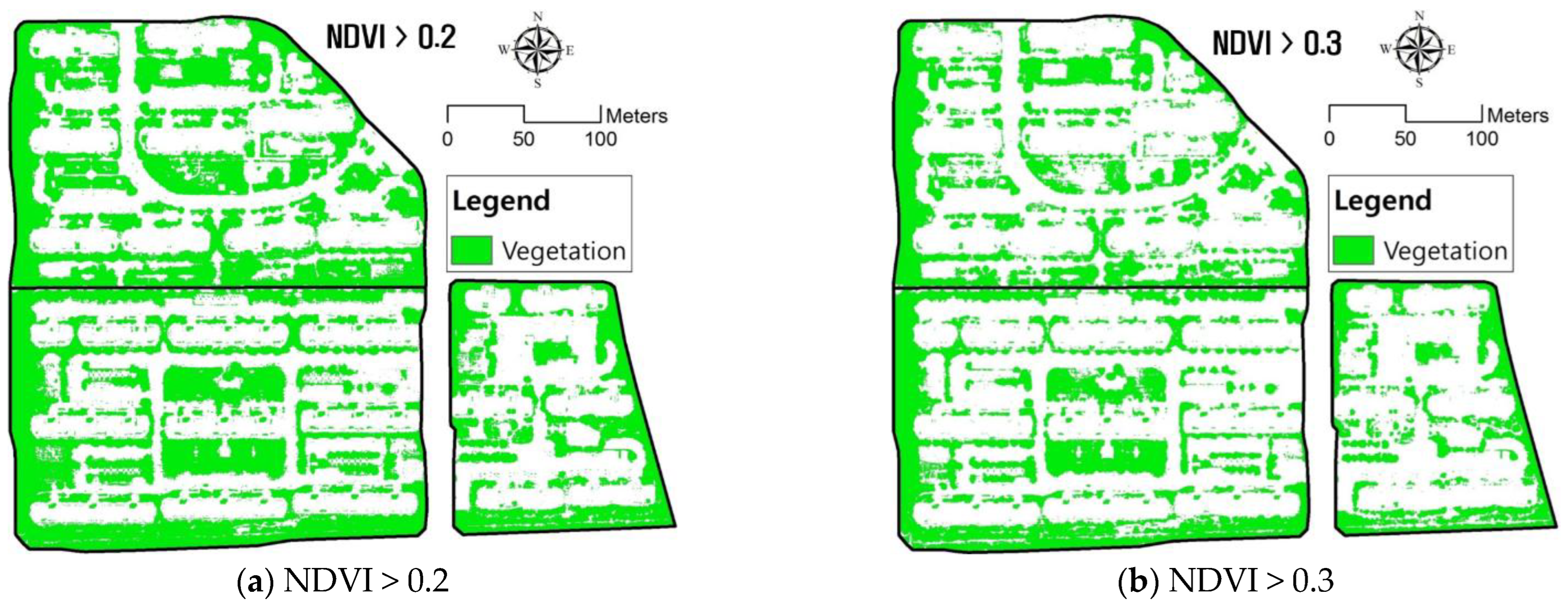
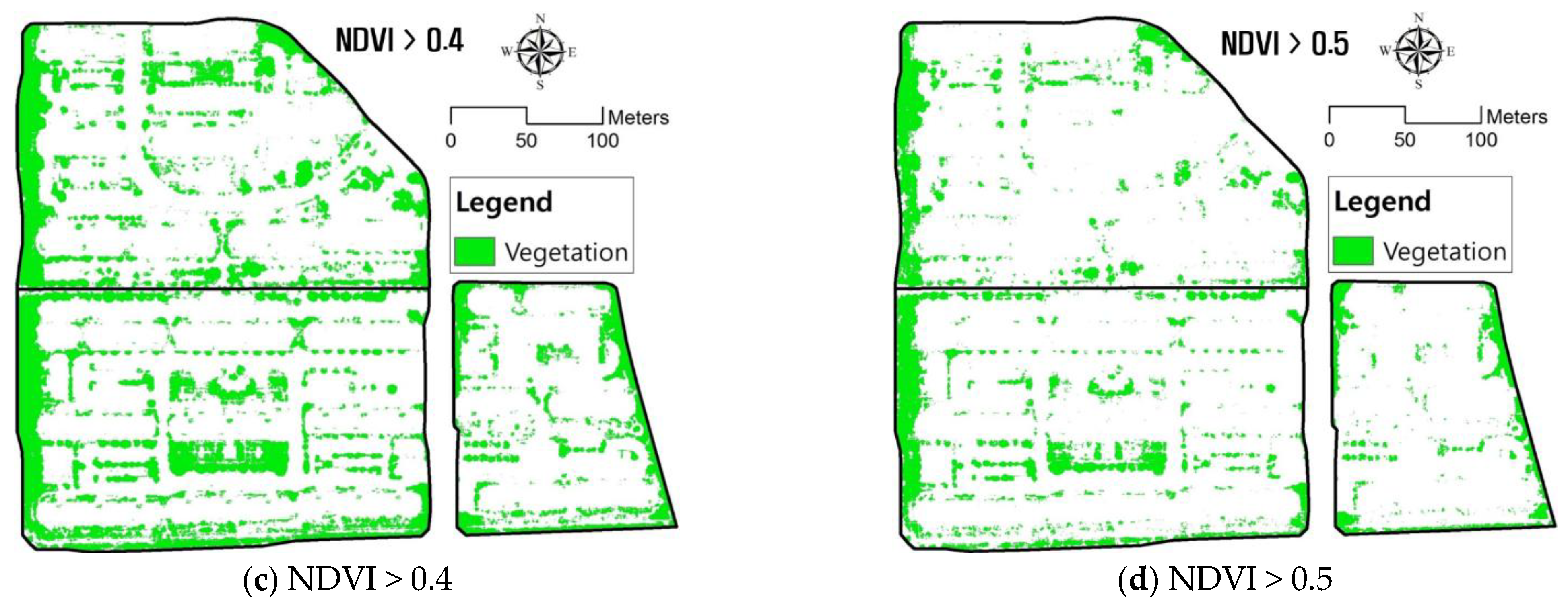
| Category | Specification |
|---|---|
| Band | Blue, Green, Red, NIR |
| Band wavelength(nm) | Blue: 450 Green: 550 Red: 625 NIR: 850 |
| Resolution | 12 Mp |
| Ground resolution at 100 m | 3.5 cm/pix |
| Sensor size | 7.44 ∗ 5.58 mm |
| Pixel pitch (width ∗ height) | 1.33 um |
| Image format | JPEG/CR2 |
| Items | Canon S110 NIR | ThermoMAP |
|---|---|---|
| Flight altitude | 114.5 m | 79.4 m |
| Ground resolution | 4.0 cm/px | 15.0 cm/px |
| Longitudinal overlap | 80% | 95% |
| Lateral overlap | 70% | 70% |
| Flight time | 18.5 min | 20.5 min |
| No. | E (m) | N (m) | Z (EL m) |
|---|---|---|---|
| 1 | 210,054.29 | 358,696.73 | 25.063 |
| 2 | 210,001.42 | 358,902.92 | 26.465 |
| 3 | 209,871.17 | 358,991.79 | 25.373 |
| 4 | 209,576.31 | 359,061.52 | 23.952 |
| 5 | 209,596.15 | 358,658.61 | 24.415 |
| 6 | 209,893.41 | 358,669.30 | 24.036 |
| Contents | Specification |
|---|---|
| Spectral range | 350–2500 nm |
| Spectral resolution | 700 nm (3 nm VNIR) 1400/2100 nm (8 nm SWIR) |
| Spectral sampling (bandwidth) | 1.4 nm (350–1000 nm) 1.1 nm (1001–2500 nm) |
| Scanning time | 100 milli seconds |
| Stray light specification | VNIR 0.02%, SWIR 1 & 2 0.01% |
| Wavelength reproducibility | 0.1 nm |
| Weight | 5.44 kg |
| Channels | 2151 |
| Vegetation Index | Minimum | Maximum |
|---|---|---|
| NDVI | −0.250 | 0.863 |
| Threshold Value of NDVI | Vegetation (m2) | Non-Vegetation (m2) | Sum (m2) |
|---|---|---|---|
| >0.2 | 49,344 | 60,669 | 110,013 |
| >0.3 | 37,201 | 72,812 | |
| >0.4 | 25,586 | 84,427 | |
| >0.5 | 14,320 | 95,693 |
| Land Cover | Reflectance | NDVI | |||
|---|---|---|---|---|---|
| Blue | Green | Red | Nir | ||
| Tree (vegetation: high) | 0.0098 | 0.0523 | 0.0133 | 0.4039 | 0.9362 |
| Grass (vegetation: medium) | 0.0311 | 0.0778 | 0.0489 | 0.2825 | 0.7048 |
| Grass (vegetation: slightly low) | 0.0291 | 0.0661 | 0.0903 | 0.2317 | 0.4391 |
| Basketball court | 0.1363 | 0.2097 | 0.1093 | 0.2733 | 0.4286 |
| Waterproof Coating roof | 0.0776 | 0.1017 | 0.0519 | 0.1276 | 0.4217 |
| Road | 0.3766 | 0.4349 | 0.4722 | 0.4429 | −0.0320 |
| Apartment Complex | Vegetation (m2) | Non-vegetation (m2) | Sum (m2) |
|---|---|---|---|
| A | 12,983 | 30,161 | 110,013 |
| B | 15,267 | 30,785 | |
| C | 6213 | 14,604 |
| Methods | Field Survey | Vegetation Analysis by UAV Images | Kappa Coefficient | ||
|---|---|---|---|---|---|
| Vegetation | Non- Vegetation | Sum | |||
| NDVI | Vegetation | 2397 | 277 | 2674 | 0.830 |
| Non- vegetation | 2 | 1647 | 1735 | ||
| Sum | 2485 | 1924 | 4409 | ||
| NDVI + Thermal infrared image | Vegetation | 2643 | 31 | 2674 | 0.934 |
| Non- vegetation | 106 | 1629 | 1735 | ||
| Sum | 2749 | 1660 | 4409 | ||
Disclaimer/Publisher’s Note: The statements, opinions and data contained in all publications are solely those of the individual author(s) and contributor(s) and not of MDPI and/or the editor(s). MDPI and/or the editor(s) disclaim responsibility for any injury to people or property resulting from any ideas, methods, instructions or products referred to in the content. |
© 2022 by the authors. Licensee MDPI, Basel, Switzerland. This article is an open access article distributed under the terms and conditions of the Creative Commons Attribution (CC BY) license (https://creativecommons.org/licenses/by/4.0/).
Share and Cite
Lee, G.; Kim, G.; Min, G.; Kim, M.; Jung, S.; Hwang, J.; Cho, S. Vegetation Classification in Urban Areas by Combining UAV-Based NDVI and Thermal Infrared Image. Appl. Sci. 2023, 13, 515. https://doi.org/10.3390/app13010515
Lee G, Kim G, Min G, Kim M, Jung S, Hwang J, Cho S. Vegetation Classification in Urban Areas by Combining UAV-Based NDVI and Thermal Infrared Image. Applied Sciences. 2023; 13(1):515. https://doi.org/10.3390/app13010515
Chicago/Turabian StyleLee, Geunsang, Gyeonggyu Kim, Gyeongjo Min, Minju Kim, Seunghyun Jung, Jeewook Hwang, and Sangho Cho. 2023. "Vegetation Classification in Urban Areas by Combining UAV-Based NDVI and Thermal Infrared Image" Applied Sciences 13, no. 1: 515. https://doi.org/10.3390/app13010515
APA StyleLee, G., Kim, G., Min, G., Kim, M., Jung, S., Hwang, J., & Cho, S. (2023). Vegetation Classification in Urban Areas by Combining UAV-Based NDVI and Thermal Infrared Image. Applied Sciences, 13(1), 515. https://doi.org/10.3390/app13010515


