Abstract
Cephalonia, located in the middle of the central Ionian Islands, has been affected by destructive earthquakes during both the instrumental and the historical period. Despite the fact that it is widely studied from several scientific viewpoints, limited research has been conducted so far regarding the earthquake-triggered landslides (ETL) and the related susceptibility. In the context of the present study, an inventory with 67 ETL from 11 earthquakes that occurred from 1636 to 2014 is presented. Given this record, the study further examines the ETL susceptibility exploiting 10 landslide causal factors in the frame of a GIS-based Analytic Hierarchy Process (AHP). Four factors (i.e., slope, PGA, tectonic structures and lithology) were associated in a higher degree to the locations where ETL occurred on the island. Based on the comparison of the ETL inventory and the landslide susceptibility index (LSI) map, the distribution of ETL in Cephalonia is not random, as their majority (82%) were generated within high to critically high susceptible zones. This fact, along with the AUC values of 80.3%, reveals a fair-to-good accuracy of the landslide susceptibility assessment and indicate that the contribution of the studied variables to the generation of ETL was effectively determined.
1. Introduction
Among the earthquake environmental effects (EEE) as defined by Michetti et al. [1], the earthquake-triggered landslides (ETL) prevail in a variety of environments from coastal to mountainous areas. They are characterized by high potential to cause not only economic but also human losses [2,3,4,5]. Casualties due to ETL are attributed to the collapse of buildings and other infrastructure due to slope failures and mobilization of unstable geological formations [6], as well as to the transport of material with high velocities over terrains with gentle slopes [7]. ETL are responsible for the 70% of all earthquake-induced human losses, which are not directly attributed to the earthquake ground motion [2], but to secondary phenomena. At least 90% of the ETL fatalities are attributed to rockfalls, rock avalanches and rapid soil flows, despite the fact that rock avalanches and rapid soil flows are neither common nor frequent events [7].
The consequences of ETL on society are not only direct, i.e., destruction of buildings and infrastructure, but also indirect, being associated with failures and damage to lifelines including road network, dams and utilities (e.g., [8,9,10]). This damage has high potential to cause disruption of various socio-economic activities including transportation as well as communication breakdown. This, in turn, can result in a delay in the emergency response and recovery actions and an increase in the number of casualties, due to delayed first aid and transport of the injured to health facilities.
ETL have been reported since 1789 BC in China [11]. The most used ETL classification has been provided by Keefer [7], who has analyzed data from a set of 40 historical earthquakes worldwide having a magnitude ranging from 5.2 to 9.5 and generating in a variety of geographic, geological and seismotectonic environments. This classification is based on the nature of the movement, the degree of the internal disruption of the mobilized material and the morphological, lithological and geological properties of the affected areas. Fourteen individual types of ETL are classified into three main categories: (i) disrupted slides and falls, (ii) coherent slides and (iii) lateral spreads and flows [7]. The first category comprises falls, slides and avalanches in rocks and soils, the second one slumps and block slides in rocks and soils as well as slow earth flows and the third one soil lateral spreads, rapid soil flows and subaqueous landslides [7]. The most common type of ETL comprises highly disrupted landslides, which includes falls, slides and avalanches involving either rock or soil, generated along steep source slopes and extending further on relatively gentle slopes [7,12].
The total number of ETL generally increases with earthquake magnitude [7] ranging from a few tens for the majority of M < 5.5 earthquakes to several thousand in M > 8.0 earthquakes.
Since the extensive research on ETL worldwide conducted by Keefer [7] and Rodriguez et al. [13], several ETL studies have been performed both at national and local level. Among others, Hancox et al. [14,15] and Rosser et al. [16] have published relevant research and databases for New Zealand, Papadopoulos and Plessa [17] for Greece, and Prestinizi and Romeo [18] and Martino et al. [19] for Italy.
Taking into account the existing literature on seismicity and EEE in the Mediterranean, we see that the Lefkada, Cephalonia, Ithaki and Zakynthos islands have been repeatedly hit by strong and destructive earthquakes with many triggered EEE (e.g., Rondoyanni et al. [20] for Lefkada Island and Mavroulis et al. [21] for Zakynthos Island). This strong seismicity is attributed to the proximity of the southern Ionian Islands to the: (i) Cephalonia Transform Fault Zone (CTFZ), which is a NE-SW striking and SE-dipping right-lateral strike-slip fault zone, the most seismic active structure in Greece and the Eastern Mediterranean and (ii) the northwesternmost part of the Hellenic Trench, along which the African plate is subducting beneath Eurasia (Figure 1).
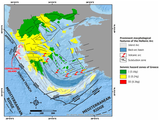
Figure 1.
The Cephalonia Island is located at the northwestern part of the Hellenic Arc, east of the Cephalonia Transform Fault Zone (CTFZ). The island belongs to the zone III of the current Greek Building Code with a Peak Ground Acceleration (PGA) value of 0.36 g for a return period of 475 years [22].
However, there is a gap regarding the inventory of ETL in Cephalonia, especially the historical ones, which are poorly recorded and mapped. The filling of this gap is considered to be of high importance since this area has suffered from the strongest and most destructive earthquake in the Ionian Sea and from the most destructive earthquake sequence in recent history of Greece: the 1867 earthquake and the August 1953 seismic sequence, respectively, with adverse effects on the local population, the building stock and the natural environment [21,23]. Moreover, Cephalonia is a highly touristic island, with millions of visitors spending time in various landslide-prone locations, especially along the coast.
In this context, we used all available sources of information to create an inventory of landslides, which have been induced from destructive earthquakes generated not only during the instrumental period, but also during the historical pre-instrumental period in Cephalonia (Figure 2). The compilation of an ETL inventory constitutes a preliminary step toward the assessment of the landslide susceptibility in one of the most seismic active areas of the world, for which, however, no relevant information has been published so far.
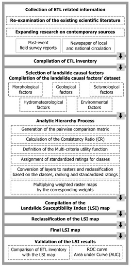
Figure 2.
Flow chart showing the approach followed for the compilation of the ETL inventory and the respective landslide susceptibility assessment in Cephalonia.
Landslide susceptibility mapping is an important tool that contributes to the mitigation of the adverse effects of disasters induced by ETL not only in Cephalonia but also worldwide. In addition, it is another significant step towards more effective and responsible urban and land-use planning and related policies, procedures, guidelines [24] and improvements in seismic and landslide hazard and risk assessment and mitigation.
In this study, we assess the landslide susceptibility of the island in order to initially detect and then highlight the areas susceptible to ETL. This assessment is composed of several steps, including the development of landslide causal factors datasets, the implementation of the Analytic Hierarchy Process (AHP) adapted to the needs of the study, the calculation of the landslide susceptibility index (LSI) and finally the validation of the resulting LSI map (Figure 2).
2. Geological and Seismotectonic Setting
The geological structure of Cephalonia comprises alpine formations that belong to the Paxi and Ionian geotectonic units and post-alpine deposits of Pliocene to Quaternary lying uncomformably on the alpine basement [25,26,27,28,29,30,31,32,33] (Figure 3). The Paxi unit occurs in the largest part of Cephalonia (Figure 3) and includes mainly carbonate rocks from Triassic to Middle Miocene and a Middle Miocene–Early Pliocene clay-clastic sequence, which includes marls, clays and limestones [32,33] (Figure 3).
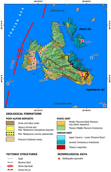
Figure 3.
The neotectonic map of Cephalonia along with epicenters of historical and recent earthquakes that triggered landslides in the island. Fault blocks are also noted (EP: Erissos peninsula, AM: Aenos Mt fault block, AP: Argostoli peninsula, PP: Paliki Peninsula) along with their marginal faults (AEF: Ayia Efimia Fault, KAF: Kontogourata–Agonas Fault, CTFZ: Cephalonia Transform Fault Zone) and other major structures (IT: Ionian Thrust).
The Ionian unit is the allochthon tectonic nappe, which crops out in the eastern part of Cephalonia emplaced on top of the Paxi unit (Figure 3). It includes a sequence of Triassic evaporites and limestone breccia as well as Jurassic–Cretaceous fine-grained limestones, red nodular limestones, and shales with the Upper Eocene–Lower Miocene flysch at the top of the sequence [32,33]. The western boundary of the Ionian unit is defined by the Ionian thrust (IT, Figure 3), which is the most external tectonic structure of the Hellenides. The Paxi and Ionian geotectonic units are affected by major reverse faults [31] (Figure 3).
The Pliocene–Quaternary deposits include the Pliocene–Calabrian sequence and the Pleistocene–Holocene formations [32,33]. The Pliocene–Calabrian sequence is a marine sequence, observed in an elevated coastal area with width ranging from 2 to 10 km, especially in the largest part of the Argostoli peninsula (AP) and in the eastern and western part of the Paliki peninsula (PP) (Figure 3). It has developed over Paxoi formations, with thickness ranging from 200 to 500 m. The lower part of the sequence is composed of conglomerates, breccia, calcarenites and limestones of the Lower Pliocene. The intermediate part includes yellowish marls with siltstones, sandstone intercalations, sands and conglomerates of the Middle-Upper Pliocene. The upper part consists of marls with intercalations of sands and coarse-grained calcarenites [29,32,33]. The Middle-Upper Pleistocene–Holocene formations occur in several places, mainly in the Argostoli peninsula (Figure 3). These are continental deposits and are classified into scree, marine calcarenites of the Middle Pleistocene, Pleistocene interglacial deposits, Pleistocene scree and Holocene deposits [32,33]. Recent deposits also occur in many sites. Red terrestrial clay sands and coastal conglomerates as well as red calcareous crusts are found in the southwestern part of AP and in the area located WSW of Skala (Figure 3). Scree and alluvial fans cover the Pliocene formations along the foothills of Aenos Mt. These formations cover many limestone slopes. Loose fine-grained and coarse-grained alluvial deposits consist of sands, cobbles and clays on narrow beaches and wide valleys of Cephalonia.
Regarding its neotectonic structure, the island is composed of the following fault blocks with different kinematic evolution [33] (Figure 2).
The fault block of Aenos Mt (AM) is located in the central and eastern part of Cephalonia. It is bounded to the southwest by the eponymous fault (AFZ—Aenos fault in Figure 3), to the northwest by the Kontogourata-Agon fault (KAF—Kontogourata-Agon fault in Figure 3), to the northeast by the Ayia Efimia fault (AEF—Ayia Efimia Fault in Figure 3) and to the southeast by the Palaeokastro fault (PF—Palaeokastro fault in Figure 3). The Aenos fault block is characterized by intense uplift and intense incision since the Lower Pliocene [32,34]. It comprises an anticline with a NW–SE to N–S trending and westward plunging axis extending for a distance of about 20 km from Myrtos in the north to Kolaitis area in the southeast.
The fault block of Erissos peninsula (EP) is located in the northern part of Cephalonia. It is bounded to the south by the Ayia Efimia fault, and it is characterized by uplift and erosion. Since the Pleistocene, the Erissos peninsula presents the same evolution as the Aenos fault block.
The Paliki peninsula is located in the western part of Cephalonia (Figure 3). It is bounded to the west by the CTFZ and especially by its southern segment, located offshore western Cephalonia. The evolution of this fault block is affected by the CTFZ throughout Pliocene–Pleistocene, an impact which is expressed through intense uplift [34]. Complex movements attributed to evaporites of the Ionian unit control local vertical movements [35,36].
The Argostoli peninsula is extended southwest and south of Aenos Mt (Figure 3). It is bounded to the east and south by the Aenos fault (Figure 3). A possible increase in compression on the Argostoli peninsula during the Pleistocene resulted in the development of back-thrust faults, exclusively in this fault block.
The main seismogenic structure in the Cephalonia area is the Cephalonia Transform Fault Zone [37,38,39] (Figure 3). It is the most seismically active structure in the Ionian Sea and one of the most active in the Eastern Mediterranean region. A large proportion of the high seismicity in the studied part of the Ionian Sea has been attributed to this structure. Based on the historical and recent seismicity, Cephalonia has been frequently stricken by large and destructive earthquakes [40] with significant impact on the local population, buildings and infrastructures (e.g., [41,42]). A special characteristic of the large earthquakes in the southern Ionian Islands is that they are usually generated as twin or cluster events with occurrence period ranging from a few days to 5 years [43]. Typical examples from Cephalonia are the 1953 earthquakes on 9–12 August and the 2014 earthquakes on 26 January and 3 February (e.g., [44]).
3. ETL Inventory in Cephalonia Island
3.1. Recent Studies on Landslide Inventory in Greece
The research for the systematic inventory of landslides in Greece is not so widespread. It mainly includes studies presenting maps with landslides throughout Greece [45,46,47,48,49] and maps of landslide-affected settlements [50] as well as several studies with results from field reconnaissance surveys in several earthquake- and landslide-affected areas, where ETL are reported and recorded among other effects.
The first attempt for the development of a complete recording system of the landslides in Greece was made by Koukis and Ziourkas [45]. They conducted a statistical analysis on 800 case histories of landslides in Greece from 1949 to 1986. The related information was retrieved from 1500 coded engineering reports and studies conducted by different public corporations including the Hellenic Authority of Geological and Mining Research (former Institute of Geology and Mineral Exploration of Greece) and the Central Union of Greek Municipalities. Their study includes cases in villages and their surroundings as well as along the road network and refers to the landslide frequency distribution and their consequences on different geological formations, altitudes, rainfall, slope angle, etc., while certain interrelations were studied and an engineering geological map as well as landslide distribution and frequency zone maps were compiled.
A similar approach was followed by Koukis et al. [46], who further evaluated data from 1116 case histories of landslides from 1949 to 1991, expanding the dataset of Koukis and Ziourkas [45]. They investigated the frequency distribution of landslide control parameters, and their results were presented in tables and graphs. Analogous extensions of the number of landslides and the time period and update of the results of the statistical analysis were conducted by Koukis et al. [47] with 1200 landslides from 1949 to 1995, by Koukis et al. [48] with 1300 landslides from 1950 to 2004 and by Sabatakakis et al. [49] with 1635 landslides up to 2010.
The landslide inventory map of Greece [50] and the above works present the landslide locations, but no additional qualitative or quantitative characteristics of the landslides, or information on their causes and time of occurrence. As a result of this approach, the marked landslides could not be associated with specific triggering events, e.g., earthquakes, rainfall or even human activity. For the ETL in Greece in general and for the Cephalonia in particular, the maps of the above studies are not significantly useful as it is not possible to determine whether the eight recorded landslides on the island were caused by earthquakes or rainfall or another triggering factor.
Furthermore, Papadopoulos and Plessa [17] collected data on 47 landslides induced by earthquakes from 1650 to 1995 with magnitude ranging from 5.3 to 7.9. Based on the ETL data, they presented magnitude-distance relations for ETL in Greece, which are compatible with curves proposed worldwide. They also examined the spatial distribution of ETL, the size distribution, and the maximum landslide distance from the epicenter. However, the collected data was not sufficient or accurate to be used for studying other parameters, such as the area affected by landslides and correlation with earthquake magnitude, as well as the minimum intensity for generating ETL. According to Papadopoulos and Plessa [17], the historical descriptions of ETL in Greece are usually not precise enough to provide a reliable basis for a modern scientific analysis. Furthermore, after examining hundreds of documents, they supported that a database with data from the 16th century onwards can be exploited.
From these 47 landslides presented by Papadopoulos and Plessa [17], only 4 were generated in the seismically active area of the Ionian Islands: a rockslide in Zakynthos from the October 30, 1840, Ms = 6.7 earthquake; a rockfall in Keri (southern Zakynthos) from the April 17, 1893, Ms = 6.4 earthquake; a rockfall in Lefkada from the 27 November 1914, Ms = 6.3 earthquake; a rockfall in the settlement of Vassiliki in southern Lefkada from the April 22, 1948, Ms = 6.5 earthquake.
In addition to the above studies, the Emergency Events Database (EM-DAT) of the Center of Research on the Epidemiology of Disasters (CRED; [51]) has also been taken into account. Based on a search for disasters induced by geophysical hazards in Europe from 1920 to present, it is concluded that the EM-DAT comprises records of ground movements caused by the 12 August 1953 and the early 2014 Cephalonia earthquakes and the 14 August 2003 Lefkada earthquake. However, there is no further information on the sites of these landslides and their qualitative and quantitative properties.
From the aforementioned, the importance of the present study is ascertained by highlighting the historical and recent ETL in Cephalonia and by presenting all available qualitative and quantitative characteristics of these phenomena on the island and the results of their analysis.
3.2. Methodology
Landslide inventories are essential for predicting future landslides generation on the basis of past conditions [52]. In order to compile a landslide inventory, various mapping approaches can be applied comprising visual interpretation of aerial and satellite imagery and field surveys and mapping, supported by investigation of contemporary sources and post-event field survey reports [52,53]. The resulting landslide inventories are classified into (i) geomorphological inventories, resulted from respective features of the study area, (ii) event inventories, associated with a specific causative event including mainly earthquakes and rainfalls, (iii) multi-temporal inventories of an area for different time periods and (iv) historical inventories for respective time periods and events [52,53].
We conducted a re-examination of the available scientific literature for historical earthquakes of Cephalonia Island with emphasis on their environmental effects and especially on the ETL. Due to the limited related information in the existing scientific literature (e.g., [41,42,54]), we expanded our search to contemporary sources, including not only post-event field survey reports (e.g., the report of the Institute of Geology and Underground Research [55]), but also daily press databases comprising newspapers of local and national circulation.
The newspaper databases comprised (Table 1):

Table 1.
Contemporary sources comprising newspapers and magazines of local and national circulation used in this study for revisiting landslides induced by historical and recent earthquakes generated in Cephalonia.
- The Press Museum of the Peloponnese—Epirus—Ionian Islands Daily Newspaper Editors Association [56];
- The Digital Historical Archive of the Lambrakis Press Group [57];
- The Digital Library of Newspapers and Magazines of the National Library of Greece [58];
- The Digital Library of the Greek Parliament [59].
The Press Museum was founded by the Association of Editors of Daily Newspapers of Peloponnese-Epirus-Islands, was based in Patras (Northwestern Peloponnese) in 1956 and has been operating since 28 May 1957. Its purpose is the collection and preservation of newspapers, magazines, manuscripts and other publications from previous centuries to present, which constitute knowledge and information sources about the history of the area. Through this website, we were given the opportunity to search for newspaper clippings about the August 1953 earthquakes. In particular, four newspapers were found (Table 1), which provided important information about the environmental effects triggered by the August 1953 earthquakes:
- ETHNIKOS KIRIX (in Greek: Εθνικός Κήρυξ; lit. National Herald, abbreviated by EK)
- I IMERA (in Greek: H Hμέρα; lit. The Day, abbreviated by IM)
- NEOLOGOS PATRON (in Greek: Νεολόγος Πατρών; lit. Patras Neologist, abbreviated by NP)
- PELOPONNISOS (in Greek: Πελοπόννησος; lit. Peloponnese, abbreviated by PL)
The Digitized Historical Archive of the Lambrakis Press Group comprises black and white as well as colored newspapers and magazines, volumes and microfilms in various dimensions (from A2 to A4) from 1922 to present. From this archive, we managed to retrieve related information from two newspapers of national circulation (Table 1), which provided information about the August 1953 earthquake sequence:
- TO VIMA (Greek: TO BHMA, lit: The Tribune, abbreviated by TV)
- TA NEA (Greek: TA NEA, lit: The News, abbreviated by TN)
The Digital Library of Newspapers and Magazines of the National Library of Greece includes digitized archives of newspaper sheets. Through the website of the digital library, we searched information for the post-earthquake period from two newspapers (Table 1):
- ANAMORFOSIS (Greek: Aναμόρφωσις, lit: Reform, abbreviated by AN)
- AVGI (Greek: Aυγή, lit: Dawn, abbreviated by AV)
- MERIMNA (Greek: Μέριμνα, lit: Concern, abbreviated by ME)
- ELEFTHERIA (Greek: Ελευθερία, lit: Freedom, abbreviated by EL)
- EMPROS (Greek: Εμπρός, lit: Ahead, abbreviated by EM)
The information retrieved from the AN, AV and ME newspapers refers to the 1867 earthquake and from the EL and EM to the seismic sequence of 1953.
The Greek Parliament Library houses one of the richest collections of Greek and foreign newspapers and magazines from the 18th century to present. Due to the sensitivity of the material and the large number of visitors, the Library has been utilizing digitization and microfilming since the 1980s. Today, about 25,000 microfilms have been digitized to make their content accessible to all. We managed to retrieve related information from three newspapers of national circulation (Table 1):
- ELPIS (Greek: Ελπίς, lit: Hope, abbreviated by EL).
- ZIZANIO (Greek: Ζιζάνιο, lit: Pest, abbreviated by ZN).
- Taxydromos (Greek: Ταχυδρόμος, lit: The Postman, abbreviated by TD).
The information retrieved from the EL and ZN refers to the 1912 earthquake and from TD to the 1953 seismic sequence.
Furthermore, we also retrieved information included in several papers of a local journal titled “I Kefalonitiki Proodos” (English: “The Cephalonian Progress”, abbreviated by KP), which referred to the 1867 earthquake and the 1953 sequence [60,61].
The related information for the recent earthquakes has been retrieved from already published scientific papers depicting the impact of the earthquakes on the natural environment [10,62,63] and from official reports of post-event field surveys [64]. Mavroulis and Lekkas [10] revised the August 1953 earthquake sequence, which comprises the most destructive events in the recent history of Greece. In particular, the latter study reconstructed a complete picture of the primary and secondary effects on the environment of the Cephalonia, Ithaki and Zakynthos Islands induced by the mainshock of 12 August, and its large foreshocks that occurred on 9 and 11 August. Eleftheriou and Mouyiaris [64] reported detailed macroseismic observations of the earthquake in Argostoli, Sami, Lixouri and Fiskardo and their surroundings and presented environmental effects triggered by the earthquake comprising rockfalls and ground failures related to liquefaction phenomena. Lekkas and Mavroulis [62,63] presented the environmental effects triggered by the early 2014 Cephalonia earthquakes (Mw = 6.1 on January 26 and Mw = 5.9 on February 3) along with the ESI-07 intensities based on the qualitative and quantitative information of the generated coseismic and secondary phenomena.
The majority of the extracted information was also verified during field surveys and campaigns held in Cephalonia after their extraction from the aforementioned contemporary sources.
3.3. Historical and Recent ETL in Cephalonia Island
Landslides in Cephalonia have been triggered by earthquakes generated in 1636, 1658, 1767, 1867, 1912, 1953, 1983 and 2014 (Figure 4). The focal parameters of these earthquakes are presented in the following Table 2.
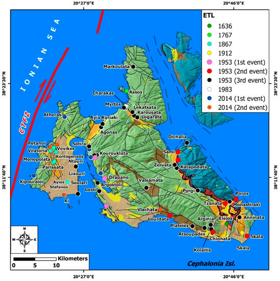
Figure 4.
The neotectonic map of Cephalonia along with the historical and recent ETL in the island. Legend of the geological formations in Figure 3.
Table 2.
Focal parameters and impact on the local population of the studied earthquakes that triggered landslides in Cephalonia Island.
3.3.1. The 30 September 1636 Earthquake
The 30 September 1636 earthquake caused severe structural damage to all buildings of Cephalonia, resulting in 520 fatalities and about 1500 injured people [41,42,67]. Heavier damage was reported in the southern part of Cephalonia, where many villages were completely destroyed. Regarding the environmental effects, the earthquake affected the southeastern part of the island. Failures, comprising slides and rockfalls, were triggered along the south facing southern slopes of Aenos Mt. Unstable limestone boulders were detached from slopes in Eleios area (Figure 4) and rolled down resulting in effects on vegetation, buildings and livestock. In particular, a part of the forest on the slopes was destroyed [42], buildings collapsed after crushing and animals were buried under debris.
3.3.2. The 24 August 1658 Earthquake
This earthquake affected the western part of Cephalonia [41,42]. It caused the destruction of 500 houses, resulting in 20 fatalities [67,68,69]. As regards the induced earthquake environmental effects, Tsitselis [69] referred to the triggering of landslides in the coastal eastern part of Paliki peninsula (Lixouri) resulting in submergence of two coastal sites. Furthermore, ETL were induced, resulting in the collapse of a church founded on the top of a hill. Unfortunately, there is no more information available for determining the exact location of the induced phenomena.
3.3.3. The 22 July 1767 Earthquake
Cephalonia was also affected by the 22 July 1767 earthquake [41,42,67,70,71]. Lixouri, in the eastern part of Paliki peninsula, was completely destroyed, Argostoli, in the northern part of the eponymous peninsula, was less affected, while Sami, in the eastern part of the island, and Fiskardo, in the northern part of Erissos peninsula, were extensively damaged as all churches and monasteries were razed to the ground [72,73,74]. As a result, 303 fatalities were reported, with 50 of them in Paliki peninsula [69]. Concerning the ETL, rockfalls were generated in Assos area, located in the central-western part of Erissos peninsula [75,76] (Figure 4).
3.3.4. The 4 February 1867 Earthquake
This earthquake is the largest that ever hit the Ionian Sea. The greatest damage was observed in the western part of Cephalonia, especially in Paliki peninsula, where Lixouri and the surrounding villages as well as residential areas in Thinia valley were completely destroyed ([67]; AN, 04.02.1867; AV, 06.02.1867; ME, 07.02.1867). As a result, 3200 houses were destroyed and 2600 were damaged, resulting in 224 fatalities [42].
Concerning ETL, rockfalls and slides were reported in Paliki peninsula. Large volume of clay material failed resulting in a large ground crack with depth of 8 m and width of 3 m in Ayios Stefanos area in southern Paliki [76]. In the same area, and particularly in Soulari village, landslides were also induced during the 2014 earthquake [62]. In addition, debris slides and rockfalls were triggered by the 1867 earthquake in Parissata, Monopolata, Vilatoria, Vovikes and Kontogenada villages, all in the central western part of Paliki peninsula, without causing structural damage [60,68] (Figure 4).
3.3.5. The 24 January 1912 Earthquake
The 1912 earthquake destroyed what had remained intact during the great 1867 earthquake. The human losses were minimal compared to the 1867 disaster, comprising seven fatalities in Asprogerakas village, located between Eleios and Anninata villages in southeastern Cephalonia, attributed to house collapse and one in Skala village from falling debris. In Skala area, rockfalls were reported and the mobilized material ended up in the adjacent roads and fields (ZN, 28.01.1912). At a distance of 400 m from Skala village, large limestone boulders were detached from the slopes, rolled down and ended up to adjacent road resulting in traffic disruption (ZN, 28.01.1912) (Figure 4).
3.3.6. The August 1953 Seismic Sequence
The August 1953 seismic sequence comprised the mainshock on 12 August and its large foreshocks on 9 and 11 August. All earthquakes triggered landslides in Cephalonia with considerable impact on the local population and on the natural and the built environment [10]. All affected sites described below are presented in Figure 4.
- The 9 August 1953 earthquake
This earthquake induced rockfalls in the coastal quarries of Argostoli town and along the western slopes of Ayia Dynati Mt (EK, 10.08.1953; NP, 11.08.1953; PL, 11.08.1953; EM, 11.08.1953).
- The 11 August 1953 earthquake
This seismic event generated rockfalls and slides (TV, 12.08.1953; IM, 12.08.1953; NP, 12.08.1953; PL, 12.08.1953). Rockfalls were generated in Sami area (NP, 12.08.1953), in Tzanata village (PL, 12.08.1953) in Lourdata village (TV, 12.08.1953; IM, 12.08.1953) and along road slopes leading from Sami to Argostoli (TV, 12.08.1953), from Argostoli to Eleios area (IM, 12.08.1953) and along the road network leading to Chionata, Skala and Poros villages (TV, 12.08.1953).
The unstable material was accumulated on adjacent roads, resulting in traffic and communication disruption. In addition, the detached limestone boulders crushed buildings in residential areas, resulting in heavy structural building damage ranging from partial to total collapse and subsequently increased related fatalities and injuries. A characteristic example of such impact is Tzanata village, which suffered rockfall-induced complete building destruction, uprooting of trees and 14 fatalities (PL, 12.08.1953).
- The 12 August 1953 earthquake
The mainshock of the 1953 earthquake sequence induced landslides in several sites of Cephalonia. The generated landslides are classified into detachment of boulders from abrupt slopes and consequent rockfalls and slides. The majority of them were rockfalls, which affected the adjacent infrastructures including the road network and buildings in villages and towns in the earthquake-affected area. The generated landslides are presented below along with the impact on the local population and on the built environment.
Starting from northern Cephalonia, rockfalls were generated along a hill adjacent to Markoulata village, located in the northern part of Erissos peninsula [55]. In the southern part of the same fault block, rockfalls occurred along a gorge between Karousata and Lekatsata villages, causing destruction of olive trees, as well as in Logarata and Karousata villages founded along the southern slopes of Kalon Mt, resulting in damage to buildings. In the northwestern part of the transition zone between the Erissos peninsula in the north and the fault block of Aenos Mt in the south, Myrtos beach, one of the most impressive sites in Cephalonia, was also affected by rockfalls. A limestone boulder was detached from the slopes and ended up in the adjacent bay, while a church founded on the slope was completely destroyed by the generated rockfalls (EM, 14.08.1953).
Rockfalls were also triggered along the eastern margin of Thinia valley, which has been formed along the transition between the northwestern Ayia Dynati Mt located east and the northeastern Paliki peninsula located west. The reported landslides affected the upper part of Agonas village [55], the coastal Ayia Kyriaki area, where debris reached the sea, and along the slopes over Sotira beach (TX, 16.08.1953).
Rockfalls were also triggered along the abrupt slopes surrounding Kourouklata village [55] located south of the aforementioned sites. It was the worst affected village as it was completely destroyed by fallen boulders (PL, 16.08.1953). Similar phenomena were reported from north of Drapano village. The unstable blocks ended up in Argostoli Gulf without impact on residential areas [61].
Several areas were also affected by ETL in the eastern part of the fault block of Aenos Mt. Rockfalls were generated in Sami, Zervata and Katapodata villages along the western front of Avgo Mt (TN, 12.08.1953; IM, 13.08.1953; TX, 14.08.1953, 19.08.1953; [55]), in Dichalia village in the northern slopes of Avgo Mt [55], in Pyrgi village in the eastern part of Roudi Mt (TX, 19.08.1953), in Valsamata village west of Roudi Mt (TX, 14.08.1953), in Tzanata and Monastiraki villages in the southern part of the Atros Mt (TX, 14.08.1953; IM, 14.08.1953; [55]), and in Atsoupades, Kolaitis, Arginia, Chionata and Plateies villages along the southern front of Aenos Mt (IM, 13.08.53; IGUR, 1954). Similar phenomena were also induced in the southeastern end of Cephalonia, in particular in Skala and Anninata villages (TX, 14.08.1953; NP, 14.08.1953; TN, 19.08.1953).
The Argostoli and Paliki peninsula were also affected by rockfalls. In Argostoli area, rockfalls were generated along the slopes of kilns close to the town (IM, 14.08.1953, 16.08.1953) and in Faraon hill, located in Lassi area (NP, 14.08.1953, 15.08.1953; PL, 14.08.1953; IM, 15.08.1953). In Paliki, rockfalls were generated in Ntouri (Paliokastro) hill, located north of Lixouri, as well as at a cape located at the southeastern end of the peninsula. Moreover, landslides were observed along slopes in the road network leading from Sami to Argostoli and from Argostoli to Livadi, located north of Ntouri site.
The ETL had considerable impact on the local population and the natural and built environments. They affected vegetation, caused damage to infrastructures including the road network and to buildings in residential areas resulting in increasing fatalities and injuries.
Rockfalls caused damage to olive groves along the abrupt slopes of the gorge in Karousata and Lekatsata [55], in Agonas area [55] and in Ntouri area of Paliki as well as to olive groves and vineyards in Zervata area (TX, 14.08.1953). The vegetation acted as protection barrier for the residential areas, for example, in the case of Agonas, where olive trees protected its lower part from rolling boulders and subsequent destruction [55].
As regards the building damage, the ETL caused heavy structural damage in several villages and led to more fatalities and injured people. Characteristic examples of such impact are the villages of Tzanata (PL, 12.08.1953), Chionata (IM, 13.08.53), Anninata (TX, 14.08.1953) and Plateies [55], where rockfalls claimed the life of residents and increased the number of injuries, Kourouklata (PL, 16.08.1953; [55]), Valsamata (TX, 14.08.1953) and Kolaitis [55], which were totally destroyed by rockfalls, and Zervata (TX, 14.08.1953), Katapodata [55] and Atsoupades [55], where buildings suffered extensive damage by rockfalls.
Rockfalls affected several parts of the road network in Cephalonia. The main effect was the accumulation of the mobilized material on the adjacent roads resulting in temporary traffic disruption and communication breakdown between the affected residential areas. In particular, traffic disruption due to proximity to high steep slopes and to rockfalls triggered by the 12 August mainshock and the foreshocks on 9 and 11 August was reported for the road leading from Argostoli to northern Cephalonia (NP, 11.08.1953; PL, 11.08.1953; EM, 11.08.1953), from Argostoli to Sami (TV, 12.08.1953), from Argostoli to Eleios-Pronnoi area (IM, 12.08.1953) and from Sami to the surrounding villages (NP, 12.08.1953). In addition, roads connecting villages in several parts of the island were also affected. Characteristic examples are the roads in Pyrgi village (TX, 19.08.1953), in Sami and Zervata village (TN, 12.08.1953; IM, 13.08.1953; TX, 14.08.1953, 19.08.1953), in Atsoupades village (IM, 13.08.53) and in Skala area (TX, 14.08.1953) among others.
3.3.7. The 17 January 1983 Earthquake
The 1983 Ms = 7.0 earthquake [37] caused slight damage to Cephalonia, due to the fact that its epicenter was located offshore between Cephalonia and Zakynthos Islands. It mainly generated non-structural damage to buildings with reinforced concrete frame and infill walls in Lixouri, Argostoli, Sami and Fiskardo areas [64]. The largest aftershock of M = 6.2 occurred on 23 March [37], but the M = 6.0 aftershock that was generated the same day as the mainshock resulted in larger damage than the mainshock [64].
Along the road to Fiskardo, at Charakas site, rockfalls were triggered along the subvertical artificial road cut [64] (Figure 4). Limestone boulders and debris from the slope were concentrated on the adjacent road and resulted in traffic disruption. Downstream of Charakas road, on the steep coastal slope, rockfalls were also generated, resulting in sea water turbidity [64] (Figure 4).
3.3.8. The Early 2014 Cephalonia Sequence
The early 2014 Cephalonia sequence comprised two earthquakes generated on 26 January (Mw = 6.1) and 3 February (Mw = 5.9), with considerable impact on western Cephalonia [62,63]. Among other effects, the 2014 earthquakes triggered landslides mainly in Paliki peninsula (Atheras, Petanoi, Kipouraeoi, Soullari and Xi areas), along the margins of Thinia valley (Agonas and Ayia Kyriaki areas), in Myrtos coastal area, along slopes in the western part of Ayia Dynati Mt and in the southern part of Argostoli peninsula (Vlachata) [62,63]. It is significant to note that such failures were not generated in Erissos peninsula. All affected sites described below are presented in Figure 4, while representative views of the triggered effects and the affected sites are presented in Figure 5.
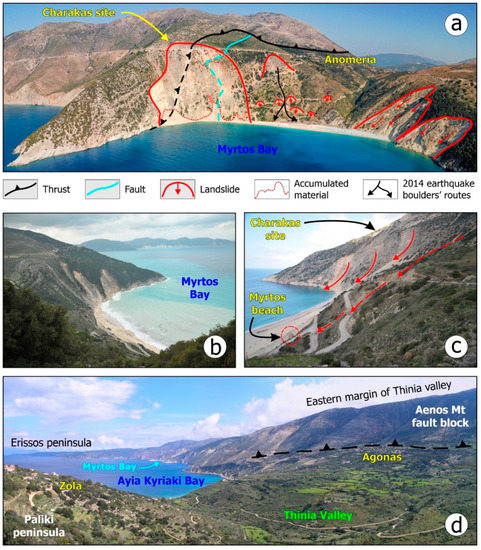
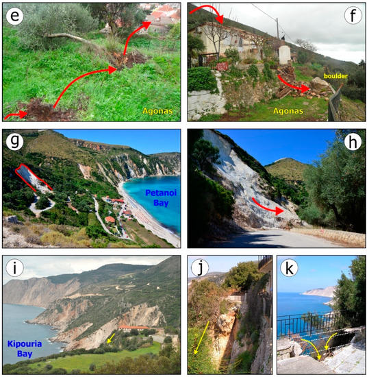
Figure 5.
The 2014 ELT in Cephalonia: (a) The landslide-prone Myrtos coastal area. (b) Water turbidity in Myrtos Bay after the 26 January 2014 earthquake attributed to rockfalls along the adjacent coastal slopes. (c) Rockfalls by the early 2014 Cephalonia earthquakes over the Myrtos beach and at Charakas site. (d) The landslide-prone eastern margin of Thinia valley, where the Kontogourata–Agonas fault occurs. Rockfalls and slides triggered in Cephalonia by the early 2014 earthquakes: (e,f) Unstable limestone boulders in Atheras village in north Paliki crushed trees and a building. (g,h) Slides in Petanoi coastal area resulting in traffic disruption. (i–k) Rockfalls close to the Kipouraioi monastery affecting its yard.
In the Myrtos area, two limestone boulders were detached from the eastern steep slope, they rolled down and stopped in the beach at about 100 m from the shoreline (Figure 5a–c). During rolling down the boulders resulted in destruction of the road leading from the top of the slope to its base. Furthermore, extensive rockfalls and rockslides were also triggered along the coastal slopes close to the beach, particularly in Charakas (Figure 5a), a site which was also affected by the 1953 and 1983 Cephalonia earthquake [55,64].
Rockfalls and slides were generated along the margins of Thinia valley, mainly in the steep slopes over Agonas village and in Ayia Kyriaki coastal area in its eastern margin and secondarily along slopes adjacent to the road leading to Zola village in its western margin (Figure 5d).
Rockfalls also affected several parts of the road network leading from Argostoli town to Livadi area located northwards. Unstable material was mobilized by the earthquake along steep road slopes and accumulated on the road asphalt surface resulting in some cases to temporary traffic disruption.
Extensive landslides were triggered on slopes of Paliki peninsula by the first earthquake on 26 January. Rockfalls were generated in its northern part, where a building in Atheras village was crushed by a rolling boulder and partially collapsed (Figure 5e,f), fortunately without casualties and injuries. During the second earthquake on 3 February, boulders in the same site were again detached from the slopes, but they did not reach the village.
Landslides were also triggered along the western coastal part of Paliki, which is characterized by high coastal fault scarps and steep slopes. Characteristic examples were recorded in Petanoi and Kipouraioi coastal areas.
In Petanoi area, the second earthquake triggered a large slide (Figure 5g,h), which reached the beach and partially covered it. In addition, the slide material blocked the road leading to the beach, resulting in traffic disruption for 3 days.
In the Kipouraeoi area, landslides were generated by both 2014 earthquakes along the impressive steep coastal fault scarps (Figure 5i–k). In the area of Kipouraeoi monastery, rockfalls and rockslides occurred along an abrupt slope, at the top of which the monastery is constructed. The crown of the slide was very close to the monastery and affected its yard (Figure 5j,k). Additionally, slides also occurred along road slopes in the area surrounding the monastery.
In the Xi coastal area, in the southern part of Paliki peninsula, small rockfalls were generated by both 2014 earthquakes. In Soulari area, an impressive slide was triggered by the 26 January earthquake on the top of a hill. A large fragment composed of silt and clay moved downhill and formed a large main scarp, while the main body of the slide was split into smaller sections. With the contribution of heavy rainfalls that followed the first earthquake, the main scarp of the slide further collapsed during the second earthquake and the pre-existing cracks were enlarged, resulting in larger gaps in the area.
The list of landslides induced by the 2014 earthquakes also includes the rockfalls triggered in the limestone quarry situated west of Vlachata village. These rockfalls temporarily blocked the road leading from Argostoli to Poros port.
3.4. Maximum Epicentral Distances as a Function of Earthquake Magnitudes
The epicentral distances of the landslides, which were induced by the aforementioned historical and recent earthquakes in Cephalonia, were calculated, taking into account the locations of the landslides, as obtained from the ETL inventory of the island, and the earthquake magnitudes, as obtained: (a) for the 1636, 1767 and 1867 earthquakes from the SHARE European Earthquake Catalogue (SHEEC) 1000–1899 [54], (b) for the 1912, 1953 and 1983 earthquakes from the updated and extended earthquake catalogue for Greece and adjacent areas since 1900 compiled by Makropoulos et al. [40] and (c) for the early 2014 earthquakes from the relocated catalogue for the 2014 Cephalonia aftershock sequence compiled by Papadimitriou et al. [77], Kapetanidis [78] and Sakkas et al. [65]. The maximum epicentral distance of landslides for each earthquake was then determined. The pairs of maximum epicentral distance of landslides and the magnitude of the causative earthquakes were plotted on a graph (Figure 6). The distribution of these points was also compared with the upper bound limit/curve for the maximum observed epicentral distances of disrupted slides and falls proposed by Keefer [7], which was based on a dataset of 40 worldwide earthquakes. This curve represents the maximum distances at which ETL can be expected to be generated for specific Mw values. The graph in Figure 6a shows how the distribution of Cephalonia ETL data generally fit well the Keefer’s relationships. In the graph in Figure 6b, together with the points for Cephalonia, the pairs of maximum epicentral distances for landslides and magnitudes for earthquakes in Greece, as presented by Papadopoulos and Plessa [17], are also shown. From these graphs, it is also concluded that outlier events attributed to various triggering factors and local seismic amplification were not recorded in Cephalonia.
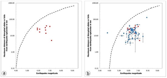
Figure 6.
(a) Maximum distance from earthquake epicenter of disrupted slides and falls induced by historical and recent earthquakes of different magnitudes generated onshore and offshore Cephalonia versus earthquake magnitude. The dashed line is the upper bound for disrupted slides or falls by Keefer [7]. (b) Maximum epicentral distances of landslides triggered by historical and recent earthquakes of different magnitudes versus earthquake magnitude. The red subset comprises data from Cephalonia and the blue subset from around Greece published by Papadopoulos and Plessa [17]. The dashed line is the upper bound for disrupted slides or falls by Keefer [7].
4. ETL Susceptibility Assessment in Cephalonia Based on GIS-Based Analytic Hierarchy Process
4.1. ETL Susceptibility Model
In the context of landslide susceptibility assessment research, 596 thematic parameters have been used so far worldwide, which are classified into five main categories, as shown in the review by Reichenbach et al. [53]: (a) geological parameters, (b) hydrological parameters, (c) parameters related to land use, (d) morphological parameters and (e) other parameters not included in the previous categories.
In the case of the assessment of landslide susceptibility in Cephalonia, the following parameters were used: (a) morphological parameters, including slope, slope aspect and slope curvature; (b) geological parameters, such as lithology of geological formations and distance from tectonic structures (faults and thrusts); (c) seismological parameters, including the peak ground acceleration (PGA); (d) environmental parameters including vegetation, derived from the NDVI index and the distance from the road network; (e) hydrometeorological parameters, such as the spatial distribution of rainfall and the distance from the drainage network (rivers and streams) (Figure 7 and Figure 8; Table 3).
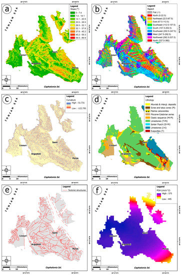
Figure 7.
Thematic maps illustrating the morphological, geological and seismological causal factors taken into account for the landslide susceptibility calculations. (a) slope, (b) aspect, (c) curvature, (d) lithology, (e) tectonic structures and (f) PGA.
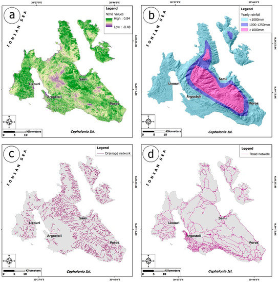
Figure 8.
Thematic maps illustrating the environmental and hydrometeorological causal factors taken into account for the landslide susceptibility calculations. (a) NDVI, (b) yearly rainfall, (c) drainage network and (d) road network.
Table 3.
Thematic layers used in the study and their sources.
Morphological slope controls the balance of restraining and destabilizing load forces acting on a slope [79,80], while forces are developed to maintain a steep rather than a gentle slope. From the statistical analysis of recorded landslides throughout Greece [81], it appears that the 16–30° class is the most susceptible one. Among the morphological parameters, slope is widely used in landslide susceptibility models, as it is the most critical parameter that contributes to the reliable estimation of susceptibility [24,82,83,84] and to the definition of non-susceptible areas [85].
Slope aspect is a very important parameter as it affects the exposure of the surface to sun and dry winds and indirectly to the flora as well as to the degree of saturation and evapotranspiration of the soil. According to Guzetti et al. [86,87], at northern hemisphere latitudes, where Ionian Islands are located, N- and NW-facing slopes are more prone to failures due to lower temperatures and more shade, factors that favor soil moisture retention.
A concave surface is more likely to suffer landslides, as after prolonged rainfall it can retain and store rainwater for longer time periods, unlike a curved surface. Additionally, a curved slope can delineate the rocky bedrock that is likely to be present in the area. Areas with positive curvature values identify curved surfaces and correspondingly negative values indicate concave surfaces. A zero curvature value indicates a flat surface. The more negative a value is, the higher the probability of landslide, while on the contrary, a surface with a positive curvature value (curved surface) is less likely to experience landslide phenomena.
The maps of slope, aspect and curvature (Figure 7a–c, respectively) were derived from the digital elevation model (DEM) of Cephalonia generated from the TanDEM-X mission, which was based on very high resolution (VHR) synthetic aperture radar (SAR) X-band data [94]. The TanDEM-X global DEM was initially introduced in 2016, based on the processing of SAR data, which were acquired within the years 2011 and 2012, succeeded a spatial DEM resolution of 0.4-arcsecond (ca. 12 m) with the aim of establishing a 2 m relative height accuracy [95,96,97]. Independently published comparisons prove an of TanDEM-X DEM smaller than ±0.20 m, a root-mean-square error (RMSE) smaller than 1.4 m and an excellent absolute 90% linear height error below 2 m. The assessed accuracy of these data sets is rather excellent and are used quite often for geomorphological and hydrological modeling [98,99].
Concerning the geological parameters used for the assessment of landslide susceptibility, the bedding of formations [100,101], the presence of faults and especially the presence of active faults in seismic active areas [102,103,104,105,106] and local hydrogeological features [24,107] are common in relevant models. The distance to tectonic structures and especially to faults is the most widespread parameter, derived from simple mapping of geo environmental and other data [53,108,109]. Consideration must be given to the fact that the faulted rock along the zone and the surrounding unfaulted rock behave differently during the occurrence of an earthquake, and each fault responds differently to each seismic event, even within the same fault zone.
Regarding the geological parameters used for assessing landslide susceptibility, the presence of scree, talus cones and clastic formations of various age is an aggravating factor for the occurrence of slope failures by earthquakes. Alluvial deposits have little or no influence on the occurrence of these phenomena, while carbonate rocks are susceptible to slides and rockfalls in cases where a steep slope has been formed either by geological processes (e.g., fault zones, incision, erosion, etc.) or by human intervention (e.g., steep road slopes, etc.). Both geological parameters, lithology and tectonic structures, in the case of the landslide susceptibility in Cephalonia were derived from the Neotectonic Map of Cephalonia [32] (Figure 7d,e).
Earthquakes are considered to be a main factor in landslide susceptibility, which is why they are taken into account in relevant studies worldwide, as in Greece [110,111] and Central Asia [112]. In seismic hazard calculations related to landslide susceptibility studies, co-seismic strong ground motion, which is the cause of damage after the occurrence of large earthquakes, is most often expressed in terms of peak ground acceleration (PGA). PGA is often obtained from probabilistic seismic hazard assessment (PSHA). It is mainly preferred as an earthquake metric, as it refers to the overall seismicity of the study area [110]. Another reason is that PGA has been used in many studies in order to determine earthquake-induced displacements [49,113,114,115].
PSHA in the framework of the present study, in terms of PGA, was adopted by Sakkas et al. [65], who applied the Cornell and McGuire method [116,117] that requires a seismotectonic model. Regarding the latter, the seismogenic crustal area source model of the European Seismic Hazard Model (ESHM), proposed by the Seismic Hazard Harmonization in Europe (SHARE) project [118,119], was used. The required seismicity parameters for PSHA, i.e., the b-value, earthquake rate and maximum magnitude for each zone, were taken from Sakkas et al. [65]. The Modified Gutenberg–Richter (MG-R) model [120,121] was adopted as the earthquake occurrence model. The Ground Motion Prediction Equation (GMPE) of Danciu and Tselentis [122] was used for the prediction of the PGA distribution. It is worth noting that this GMPE, obtained using Greek data, can be considered as reliable, as it has been applied in many PSHA studies in Greece (e.g., [123,124,125]). The R-CRISIS software [126] was utilized to obtain PGA for a return period of 475 years for Cephalonia Island, considering a rock basement and faulting types corresponding to reverse or strike-slip focal mechanisms (Figure 7f).
In terms of land use, the majority of researchers use combinations of vegetation, land cover and land use from existing maps prepared after visual interpretation of aerial photographs and more recently from automatic or semi-automatic processing of satellite imagery at various scales [127,128] and in different regions, maps showing changes in vegetation or land use [129,130,131,132]. The rationale behind incorporating vegetation into landslide susceptibility models is that vegetation depends on slope stability. The normalized difference vegetation index (NDVI) gives a quantitative estimation of the vegetation growth and biomass in the study area and constitutes an index used in landslide susceptibility studies worldwide. NDVI values range from +1.0 to −1.0. Very low NDVI values (for example, 0.1 or less) correspond to no vegetation cover and exposure of the unvegetated area to surface erosion processes and subsequent slope failures [133]. Moderate NDVI values ranging approximately from 0.2 to 0.5 correspond to sparse vegetation, while high NDVI values ranging approximately from 0.6 to 0.9 correspond to dense vegetation [133]. Thus, the lowest NDVI value has the highest impact on the occurrence of landslides. In this study, Sentinel 2 satellite images were used (acquisition date 21.04.11) and the index was calculated by using the red and near infrared spectral bands [134] (Figure 8a), according to the following formula NDVI = (NIR − R)/(NIR + R), where NIR and R are the observed reflectance in the near infrared and red portions of the electromagnetic spectrum, respectively.
Regarding the hydrometeorological parameters, the average annual precipitation, leads to an increase in landslide susceptibility by affecting the water content of rock/soil. In this case, gridded precipitation data were collected from the Hellenic National Meteorological Service [88], based on which the spatial distribution of the average annual rainfall in Cephalonia was modelled in raster form (Figure 8b).
Concerning the environmental parameters and the influence of the drainage network, the distance from drainage network is used according to the following approach: rivers and streams can influence the probability of landslide occurrence, as their erosive processes especially at the base of the slopes and the intense incision across active faults and increase the instability conditions of the slopes and the susceptibility of landslides. As the distance from the branches of the drainage network increases, the susceptibility to landslide events decreases. Rivers and streams in the study area were derived from the topographic maps of the Hellenic Military Geographical Service in 1:50,000 scale [89,90,91,92] (Figure 8c).
Due to inadequate drainage and destabilization of hillslopes by undercutting and overloading, landslides are more frequent near the road network [135]. With increasing distance from the road network, the landslide susceptibility in an area decreases. Important information on landslide susceptibility along the road network is obtained from the study of the history of such events. The road network in the study areas was derived from the topographic maps of the Hellenic Military Geographical Service in 1:50,000 scale [89,90,91,92], which was then updated by using OpenStreetMap [93] (Figure 8d).
After the factors were selected, they were classified into classes and rank values and standardized ratings were assigned for these classes (Table 4).
Table 4.
Landslide causal factors, classes, rank values, standardized ratings and weights used in the landslide susceptibility assessment in Cephalonia.
In order to evaluate the relative weight of each factor, the Analytic Hierarchy Process (AHP) developed by Saaty [136] was selected as a decision tool. In the frame of the AHP, all factors are compared pairwise by taking into consideration the intensity of their significance and contribution to the generation of ETL, as it is derived from expert opinions, experience and knowledge gained from previous events. In the current study, the SpiceLogic Inc. Analytic Hierarchy Process Software (trial version 3.4.5) [137] was used. In total, 45 pairwise comparisons undertaking an approximate eigenvector calculation were conducted resulting in the pairwise comparison matrix, the consistency ratio and the multi-criteria utility function (Table 5; Figure 9). For the consistency ratio, Saaty [136] suggested that it should be less than or equal to 0.1, to accept the weights. The consistency ratio in this case, as derived from the software, is equal to 0.071, which reveals a suitable and reasonable level of consistency in the pairwise comparison that is a satisfactory value to recognize and estimate the factors weights.
Table 5.
Pairwise comparison matrix regarding the landslide causative factors as required for applying the AHP method.
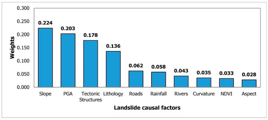
Figure 9.
Ranking of weights for the 10 landslide causative factors.
Next, the thematic layers of the distance to roads, to rivers and to faults were calculated with the use of the Euclidean distance tool included in the Spatial Analyst toolbox of ArcGIS 10.7 [138]. The thematic maps were converted to raster datasets, which were then reclassified based on the aforementioned classes, ranking and standardized ratings. The resulting weighted raster thematic maps were multiplied by the corresponding weights based on the multi-criteria utility function (Table 5) with Raster Calculator tool of the Spatial Analyst toolbox in ArcGIS 10.7. This tool allows researchers to create and execute Map Algebra expressions for outputting a raster. The zonation map is obtained from the sum of the weighted map. Each cell of the map resulted from the aforementioned calculation is characterized by a certain landslide susceptibility index (LSI) value. The final earthquake-triggered landslide susceptibility map of Cephalonia Island comprises seven susceptibility zones (non-susceptible, very low, low, moderate, high, very high, and critically high susceptibility) (Figure 10) according to the Jenks natural breaks classification method [139]. The area of each zone as well as the percentage on the total area of the studied island is presented in Table 6.
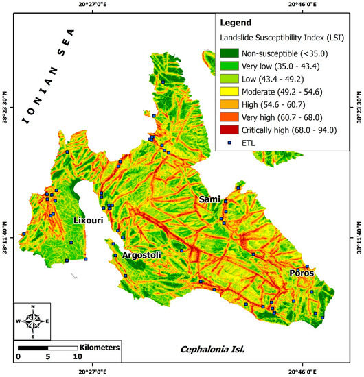
Figure 10.
The landslide susceptibility index (LSI) map of Cephalonia Island, against the recorded ETL.
Table 6.
Areas of susceptibility map classes.
4.2. Validation of the Model
The creation of the landslide susceptibility map was followed by the verification of the accuracy of the landslide susceptibility model. The validation of the landslide susceptibility results is usually carried out by applying two methods in the frame of the relevant studies. The first approach involves the comparison of the landslide susceptibility map with an inventory map, which includes landslide events in the study area (e.g., [110,111,140,141,142]). The second approach involves the use of the receiver operating characteristic (ROC; [143,144,145]). The result of this approach is a success rate resulting from the comparison between the earthquake-triggered landslide grid cells and the earthquake-triggered landslide susceptibility grid (e.g., [146]).
Both approaches were used in this study for Cephalonia. For the first one, the ETL inventory in Cephalonia from 1636 to 2014 was used. The majority of the 67 landslides occurred in areas of high (24/67, 35.82%), very high (16/67, 23.88%) and critically high (15/67, 22.39%) susceptibility (Table 7). In total, 55 out of 67 events (82.09%) occurred in high to critically high susceptibility zones, while 12 occurred in low to medium susceptibility zones (3 in low and 9 in medium susceptibility zones, with a percentage of 4.48% and 13.43%, respectively) (Table 7).
Table 7.
Distribution of the recorded historical and recent ETL in the detected landslide susceptibility zones of Cephalonia Island.
For the second approach based on the ROC curve, the curves are obtained by plotting in a graph with both axes having values ranging from 0 to 1. The x-axis comprises values of false positive rate based on the resulting earthquake-triggered landslide susceptibility map and the y-axis comprises values of true positive rate based on the ETL sites. The accuracy of the model is related to the area under the curve (AUC). The AUC ranges from 0.5 to 1.0 [147,148] with a value equal to 1.0 corresponding to a perfect model prediction accuracy. A value found along the diagonal line of the graph implies a 50% probability of predicting the generation of landslides. The larger the value of the AUC, the better the landslide susceptibility model predicts susceptible areas and landslides. In the case of Cephalonia, the ROC graph and the AUC have been derived by using the ArcSDM tools in ArcGIS 10.7. The AUC was calculated as 0.803 (Figure 11), which reveals fair to good model prediction accuracy.
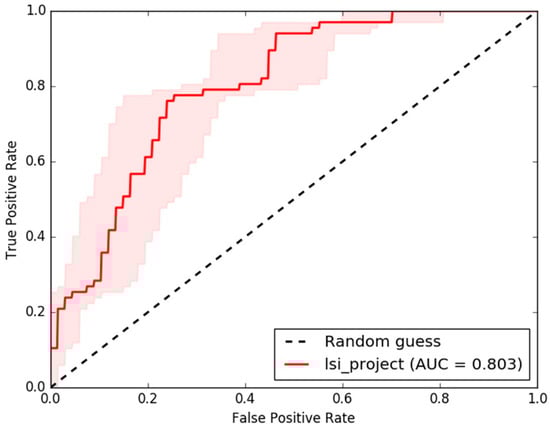
Figure 11.
ROC graph and AUC for the landslide susceptibility model applied for Cephalonia.
5. Discussion
This work explores earthquake-triggered landslides (ETL) on the island of Cephalonia, one of the most active areas in the Mediterranean region. The study addresses the gap in the record of past events and examines the ETL susceptibility of the island exploiting the long record that has been created. Given the rich record of the identified ETL phenomena, the island is considered to be particularly prone to slope failures due to earthquakes.
From the implemented inventory, it is concluded that 67 cases were induced by earthquakes in Cephalonia from 1636 to 2014, with most of them being triggered by the 12 August 1953 earthquake (30 cases, 44.78%). The majority of failures have been reported from earthquakes after 1900 (Figure 12). Although historical earthquakes that have affected Cephalonia had magnitudes larger than 5.9, information on environmental effects, despite their important impacts, is limited. This does not mean that these events did not cause such effects, but it is probably due to the fact that the interest of residents, authorities and researchers at the time was mainly focused on damage to buildings which were mainly associated with unpleasant effects on the local population. In addition, the earthquake effects resulted usually in heavy damage of the road network, disrupting transportation between local villages, making it impossible for researchers to record the complete impact of earthquakes on both the natural environment and the building stock. This situation seems to have changed after the first half of the 20th century, as evidenced by the plethora of recorded landslides caused by the 1953, 1983 and 2014 earthquakes.
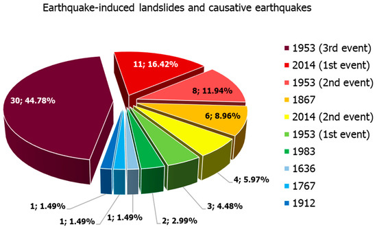
Figure 12.
Pie charts showing the number and percentages of landslides triggered in Cephalonia Island by earthquakes from 1636 to 2014. The majority has been generated by the 1953 earthquake sequence.
Based on the rich record of ETL developed, it was possible to validate the result of landslide susceptibility analysis in terms of spatial distribution. In the course of this analysis, we used not only morphological and geological variables as the causative factors, but also seismological, hydrometeorological and environmental parameters, in order to effectively identify and precisely map the most susceptible zones in the island. Both from the landslide susceptibility map individually and from the comparison of the historical and landslide susceptibility maps, it was found that the spatial distribution of the studied effects in Cephalonia is not random. They were mainly generated in certain zones with high to critically high susceptibility to landslide triggering in the case of strong earthquake ground motion. These zones include the following from north to south:
- The northern margins of Pylaros valley, located between Kalon Mt to the north and Ayia Dynati to the south, constitutes one for the most susceptible zones. Along the southern slopes of Kalon Mt, the Ayia Efimia oblique slip reverse fault occurs, which has formed a highly fractured and deformed rock mass, susceptible to slope failure from earthquakes. This situation is highlighted not only by the slope failures generated during the 1953 earthquakes at Lekatsata, Logarata and Karousata villages (Figure 4), but also by similar impressive effects that have taken place further west, in the coastal area of Myrtos bay during the occurrence of the devastating earthquakes of 1953, 1983 and 2014 [10,62,64], which resulted in damage and destruction of adjacent sections of the road network and temporary traffic disruption. It is important to mention that the coastal area of Myrtos is particularly prone to slope failures, caused not only by earthquakes, but also during extreme hydro-meteorological events. A typical example for the later events is the case of the “Ianos” Mediterranean cyclone (medicane) in mid-September 2020, which affected several areas in Greece and especially Lefkada, Cephalonia, Ithaki and Zakynthos Islands, causing flooding, mudflows and debris flows with severe impacts on networks and infrastructure of Cephalonia (Assos area in the Erissos peninsula, and Myrtos and Ayia Efimia areas at the western and eastern ends of the Pylaros valley, respectively; [149,150]).
- The eastern margins of Thinia valley, where the Kontogourata–Agonas oblique slip reverse fault occurs, is also among the most earthquake-triggered landslide-susceptible zones in Cephalonia. This fault places the northwestern part of Aenos Mt on the northeastern part of Paliki peninsula and is responsible for the rugged morphology, dense discontinuities and the decreased cohesion in the area. Along this susceptible zone, landslides were induced by the 1953 and 2014 earthquakes.
- The high steep mountain slopes in the western, eastern and southern parts of Aenos Mt fault block are characterized by high to critically high susceptibility, strongly related to the eponymous fault zone, which bounds the mountain to its south and west. As a result of the presence and activity of the zone, extensive outcrops of scree and talus cones as well as fragmented limestone of the Paxi unit participated in the geological setting and led to the generation of landslides during the 1636, 1912 and August 1953 earthquakes. In particular, the slope failures of 1953 had considerable impact on settlements in the area, which were founded on the above-mentioned formations, resulting in their partial destruction and human losses.
- Another zone susceptible to ETL is the western coastal part of the Paliki peninsula. This coastal zone has been formed and evolves under the influence of the offshore Cephalonia strike-slip fault and many smaller onshore faults. Their combined action results in the creation of extensive fault scarps and steep slopes, the majority of which are almost vertical and composed by highly fractured, brecciated and almost powdered carbonate formations.
- An important contribution to the susceptibility of Cephalonia to landslides from earthquakes is also made by certain large inactive structures and in particular the thrust of the Ionian unit over the Paxi unit. However, the formations occurring at the front of the thrust appear particularly deformed, a fact that increases the susceptibility of both the overlying Ionian unit and the underlying Paxi unit to failure. Characteristic of this zone is the occurrence of landslides in the wider area of Sami during the 1953 earthquake sequence, with impact on adjacent settlements and parts of the road network.
- The southern part of the Paliki peninsula is locally characterized by high susceptibility, mainly along slopes, which are made up of not very compact mineral deposits. Typical cases of landslides have occurred along slopes in the southern and eastern coastal areas near the town of Lixouri.
Concerning the ETL distribution in the fault blocks of Cephalonia, the most affected in terms of ETL is the fault block of Aenos Mt and the eastern Cephalonia followed by Paliki, Erissos and Argostoli peninsulas.
6. Conclusions
The landslide susceptibility map was classified according to the natural break method into seven classes of critically high, very high, high, moderate, low, very low, and no susceptibility (Figure 10) corresponding to 3.48%, 9.76%, 14.97%, 19.57%, 23.16%, 20.60% and 8.46% of the total study area respectively (Table 6).
Overall, from qualitative assessment of the distribution of the landslides, illustrated in the description of the aforementioned most susceptible zones, it was concluded that four factors (i.e., slope, PGA, tectonic structures and lithology) were associated in a higher degree to the locations where ETL occurred on Cephalonia Island. This supports the difference between this group of parameters and the rest in terms of weighting factors estimated in AHP.
It should be also noted that despite the limited extent of high to critically high susceptible zones in the island (28.21% of its total area based on Table 6) they host 82% of the ETL phenomena included in the inventory. This fact along with the AUC values of 80.3% reveals a fair-to-good accuracy of the landslide susceptibility assessment in the island. Furthermore, the validation results indicate that the geoenvironmental conditions and the contribution of the studied variables to the generation of the landslides were effectively detected and determined.
Such landslide susceptibility assessment approaches are interesting from the scientific viewpoint, but mostly they are useful and necessary for decision making regarding effective and responsible land-use planning and environmental development. The combined use of ETL inventories and susceptibility maps maximizes the information content provided to the involved decision-makers, planners and other stake-holders.
Such applied studies give the opportunity and the possibility to all involved parties from the research community and the risk professionals to further and in detail identify the most important landslide triggering factors, to understand the contribution of several parameters to the generation of landslides to seismically active areas and to interpret the generation mechanisms and processes of landslides. Furthermore, by taking into account the results of such studies, the authorities involved in disaster risk reduction acquire related knowledge in order to adopt preventive measures and site-specific mitigation strategies. These strategies have the potential to mitigate the adverse effects of ETL to the natural environment and the building stock and eliminate and reduce human and economic losses, respectively.
The application of similar approaches is expected to be extensive in the future as urbanization and development have already expanded and will further expand to areas prone to landslides, while the simultaneous presence of landslide causal factors will be continuous and the occurrence of landslide triggering events constantly increasing. Furthermore, it is also expected that the processes applied in the landslide susceptibility models will also be used to other fields of assessment of related hazard and disaster risk reduction.
Author Contributions
Conceptualization, S.M.; methodology, S.M. and M.D.; software, S.M. and M.D.; validation, S.M. and M.D.; formal analysis, S.M. and M.D.; investigation, S.M. and M.D.; resources, N.V. and E.L.; data curation, S.M., M.D., V.K. and I.S.; writing—original draft preparation, S.M., M.D., V.K. and I.S.; writing—review and editing, S.M., M.D., H.K., E.V., V.K., I.S., G.K., E.S., N.V. and E.L.; visualization, S.M. and M.D.; supervision, S.M.; project administration, N.V. and E.L.; funding acquisition, N.V. and E.L. All authors have read and agreed to the published version of the manuscript.
Funding
This research was partially funded by the “Telemachus—Innovative Operational Seismic Risk Management System of the Ionian Islands” project, included in the Priority Axis “Environmental Protection and Sustainable Development” of the Regional Operational Programme “Ionian Islands 2014–2020”, grant number MIS 5007986, which is funded by the European Regional Development Fund (ERDF) and National Resources under the National Strategic Reference Framework NSRF 2014–2020.
Institutional Review Board Statement
Not applicable.
Informed Consent Statement
Not applicable.
Data Availability Statement
Data available on request from the corresponding author.
Conflicts of Interest
The authors declare no conflict of interest.
References
- Michetti, A.M.; Esposito, E.; Guerrieri, L.; Porfido, S.; Serva, L.; Tatevossian, R.; Vittori, E.; Audemard, F.; Azuma, T.; Clague, J.; et al. Environmental Seismic Intensity Scale 2007—ESI 2007; Memorie Descrittive Della Carta Geologica d’Italia; Guerrieri, L., Vittori, E., Eds.; Agenzia per la Protezione dell’Ambiente e per i Servizi Tecnici (APAT): Roma, Italy, 2007; pp. 1–41. [Google Scholar]
- Marano, K.D.; Wald, D.J.; Allen, T.I. Global earthquake casualties due to secondary effects: A quantitative analysis for improving rapid loss analyses. Nat. Hazards 2010, 52, 319–328. [Google Scholar] [CrossRef]
- Petley, D. Global patterns of loss of life from landslides. Geology 2012, 40, 927–930. [Google Scholar] [CrossRef]
- Kennedy, I.T.R.; Petley, D.N.; Williams, R.; Murray, V. A Systematic Review of the Health Impacts of Mass Earth Movements (Landslides). PLoS Curr. 2015, 30, 7. [Google Scholar] [CrossRef] [PubMed]
- Nowicki Jessee, M.A.; Hamburger, M.W.; Allstadt, K.; Wald, D.J.; Robeson, S.M.; Tanyas, H.; Hearne, M.; Thompson, E.M. A global empirical model for near-real-time assessment of seismically induced landslides. J. Geophys. Res. Earth Surf. 2018, 123, 1835–1859. [Google Scholar] [CrossRef] [Green Version]
- Bird, J.F.; Bommer, J.J. Earthquake losses due to ground failure. Eng. Geol. 2014, 75, 147–179. [Google Scholar] [CrossRef]
- Keefer, D.K. Landslides caused by earthquakes. Geol. Soc. Am. 1984, 95, 406–421. [Google Scholar] [CrossRef]
- Marui, H.; Nadim, F. Landslides and Multi-Hazards. In Landslides—Disaster Risk Reduction; Sassa, K., Canuti, P., Eds.; Springer: Berlin/Heidelberg, Germany; pp. 435–450.
- Shieh, C.-L.; Wang, C.-M.; Lai, W.-C.; Tsang, Y.-C.; Lee, S.P. The composite hazard resulted from Typhoon Morakot in Taiwan. J. JSECE 2009, 62, 61–65. [Google Scholar] [CrossRef]
- Mavroulis, S.; Lekkas, E. Revisiting the Most Destructive Earthquake Sequence in the Recent History of Greece: Environmental Effects Induced by the 9, 11 and 12 August 1953 Ionian Sea Earthquakes. Appl. Sci. 2021, 11, 8429. [Google Scholar] [CrossRef]
- Hansen, A.; Franks, C.A.M. Characterization and mapping of earthquake triggered landslides for seismic zonation. State-of-the-art Paper. In Proceedings of the Fourth International Conference on Seismic Zonation, Stanford, CA, USA, 26–29 August 1991; Volume 1, pp. 149–195. [Google Scholar]
- Keefer, D.K. Landslides generated by earthquakes: Immediate and long-term effects. In Treatise on Geomorphology; Shroder, J., Owen, L.A., Eds.; Academic Press: San Diego, CA, USA, 2013; Volume 5, pp. 250–266. [Google Scholar]
- Rodriguez, C.; Bommer, J.; Chandler, R. Earthquake-induced landslides: 1980–1997. Soil Dyn. Earthq. Eng. 1999, 18, 325–346. [Google Scholar] [CrossRef]
- Hancox, G.T.; Perrin, N.D.; Dellow, G.D. Earthquake-Induced Landsliding in New Zealand and Implications for MM Intensity and Seismic Hazard Assessment; Institute of Geological & Nuclear Sciences Client Report 43601 B; Lower Hutt: Wellington, New Zealand, 1997. [Google Scholar]
- Hancox, G.T.; Perrin, N.D.; Dellow, G. Recent studies of historical earthquake-induced landsliding, ground damage, and MM intensity in New Zealand. Bull. N. Z. Soc. Earthq. Eng. 2002, 35, 59–95. [Google Scholar] [CrossRef] [Green Version]
- Rosser, B.; Dellow, S.; Haubrock, S.; Glassey, P. New Zealand’s National Landslide Database. Landslides 2017, 14, 1949–1959. [Google Scholar] [CrossRef] [Green Version]
- Papadopoulos, G.A.; Plessa, A. Magnitude–distance relations for earthquake-induced landslides in Greece. Eng. Geol. 2000, 58, 377–386. [Google Scholar] [CrossRef]
- Prestininzi, A.; Romeo, R. Earthquake-induced ground failures in Italy. Eng. Geol. 2000, 58, 387–397. [Google Scholar] [CrossRef]
- Martino, S.; Prestininzi, A.; Romeo, R.W. Earthquake-induced ground failures in Italy from a reviewed database. Nat. Hazards Earth Syst. Sci. 2014, 14, 799–814. [Google Scholar] [CrossRef] [Green Version]
- Rondoyanni, T.; Sakellariou, M.; Baskoutas, J.; Christodoulou, N. Evaluation of active faulting and earthquake secondary effects in Lefkada Island, Ionian Sea, Greece: An overview. Nat. Hazards 2012, 61, 843–860. [Google Scholar] [CrossRef]
- Mavroulis, S.; Stanota, E.-S.; Lekkas, E. Evaluation of environmental seismic intensities of all known historical and recent earthquakes felt in Zakynthos Island, Greece using the Environmental Seismic Intensity (ESI 2007) scale. Quat. Int. 2019, 532, 1–22. [Google Scholar] [CrossRef]
- EAK. Greek Seismic Code; Earthquake Planning & Protection Organization: Athens, Greece, 2003; Volume 72, p. 7. [Google Scholar]
- Sakkas, G.; Kouskouna, V.; Makropoulos, K. Seismic hazard analysis in the Ionian Islands using macroseismic intensities. Hell. J. Geosci. 2010, 45, 239–247. [Google Scholar]
- Carrara, A.; Cardinali, M.; Detti, R.; Guzzetti, F.; Pasqui, V.; Reichenbach, P. GIS techniques and statistical models in evaluating landslide hazard. Earth Surf. Proc. Land. 1991, 16, 427–445. [Google Scholar] [CrossRef]
- Renz, C. Die Vorneogene Stratigraphie der Normal-Sedimentaren Formationen Griechenlands; Institute for Geology and Subsurface Research: Athens, Greece, 1955; p. 637. [Google Scholar]
- Aubouin, J. Contribution a l’ étude géologique de la Grèce septentrionale, les confins de l’ Epire et de la Thessalie. Ann. Géol. Pays Hellén. 1959, 10, 1–525. [Google Scholar]
- Aubouin, J.; Dercourt, J. Zone preapulienne, zone ionienne et zone du Gavrovo en Peloponncse occidentale. Bull. Soc. Géol. Fr. 1962, 4, 785–794. [Google Scholar] [CrossRef]
- Georgiadou-Dikaioulia, E. The Neogene of Kephallinia. Ph.D. Thesis, University of Athens, Athens, Greece, 1967. [Google Scholar]
- BP Co. The Geological Results of Petroleum Exploration in Western Greece; Institute of Geology and Subsurface Research: Athens, Greece, 1971. [Google Scholar]
- BP Co.; University of Munich; Migiros, G. Geological Map of Greece, “Cephalonia Island (Northern and Southern Part)”, 1:50,000 Scale; Institute of Geology and Mineral Exploration: Athens, Greece, 1985. [Google Scholar]
- Underhill, J.R. Triassic evaporites and Plio-Quaternary diapirism in western Greece. J. Geol. Soc. 1988, 145, 269–282. [Google Scholar] [CrossRef]
- Lekkas, E. “Cephalonia—Ithaki” Sheet; Scale 1:100,000, Neotectonic Map of Greece; National and Kapodistrian University of Athens: Athens, Greece, 1996. [Google Scholar]
- Lekkas, E.; Danamos, G.; Mavrikas, G. Geological Structure and Evolution of Kefallonia and Ithaki Islands. Bull. Geol. Soc. Greece 2001, 34, 11–17. [Google Scholar] [CrossRef]
- Sorel, D. Etude Néotectonique des Î;les Ioniennes de Céphalonie et de Zante et de l’ Elide Occidentale (Gréce). Ph.D. Thesis, Orsay, Université Paris Sud, Paris, France, 1976; p. 200. [Google Scholar]
- Lagios, E.; Sakkas, V.; Papadimitriou, P.; Damiata, B.N.; Parcharidis, I.; Chousianitis, K.; Vassilopoulou, S. Crustal deformation in the Central Ionian Islands (Greece): Results from DGPS and DInSAR analyses (1995–2006). Tectonophysics 2007, 444, 119–145. [Google Scholar] [CrossRef]
- Hollenstein, C.H.; Müller, M.D.; Geiger, A.; Kahle, H.-G. Crustal motion and deformation in Greece from a decade of GPS measurements 1993–2003. Tectonophysics 2008, 449, 17–40. [Google Scholar] [CrossRef]
- Scordilis, E.M.; Karakaisis, G.F.; Karacostas, B.G.; Panagiotopoulos, D.G.; Comninakis, P.E.; Papazachos, B.C. Evidence for transform faulting in the Ionian sea: The Cephalonia island earthquake sequence of 1983. Pure Appl. Geophys. PAGEOPH 1985, 123, 388–397. [Google Scholar] [CrossRef]
- Louvari, E.; Kiratzi, A.; Papazachos, B. The Cephalonia Transform Fault and its extension to western Lefkada Island (Greece). Tectonophysics 1999, 308, 223–236. [Google Scholar] [CrossRef]
- Sachpazi, M.; Hirn, A.; Clément, C.; Haslinger, F.; Laigle, M.; Kissling, E.; Charvis, P.; Hello, Y.; Lépine, J.-C.; Sapin, M.; et al. Western Hellenic subduction and Cephalonia Transform: Local earthquakes and plate transport and strain. Tectonophysics 2000, 319, 301–319. [Google Scholar] [CrossRef]
- Makropoulos, K.; Kaviris, G.; Kouskouna, V. An updated and extended earthquake catalogue for Greece and adjacent areas since 1900. Nat. Hazards Earth Syst. Sci. 2012, 12, 1425–1430. [Google Scholar] [CrossRef] [Green Version]
- Papazachos, B.; Papazachou, K. The Earthquakes of Greece; Ziti Publications: Thessaloniki, Greece, 2003; p. 286. [Google Scholar]
- Ambraseys, N. Earthquakes in the Mediterranean and Middle East, a Multidisciplinary Study of Seismicity up to 1900; Cambridge University Press: Cambridge, UK, 2009; p. 970. [Google Scholar] [CrossRef]
- Papadimitriou, E.E. Mode of Strong Earthquake Recurrence in the Central Ionian Islands (Greece): Possible Triggering due to Coulomb Stress Changes Generated by the Occurrence of Previous Strong Shocks. Bull. Seism. Soc. Am. 2002, 92, 3293–3308. [Google Scholar] [CrossRef]
- Bonatis, P.; Akinci, A.; Karakostas, V.; Papadimitriou, E.; Kaviris, G. Near-fault broadband ground motion simulation applications at the Central Ionian Islands, Greece. Pure Appl. Geophys. 2021, 20, 10. [Google Scholar] [CrossRef]
- Koukis, G.; Ziourkas, C. Slope instability phenomena in Greece: A statistical analysis. Bull. Int. Assoc. Eng. Geol. 1991, 43, 47–60. [Google Scholar] [CrossRef]
- Koukis, G.; Tsiambaos, G.; Sabatakakis, N. Slope movements in Greek territory: A statistical approach. In Proceedings of the 7th International Congress of IAEG, Lisboa, Portugal, 5–9 September 1994; Oliveira, R., Rodrigues, L.F., Coelho, A.G., Cunha, A.P., Eds.; A. A. Balkema: Rotterdam, The Netherlands, 1994; pp. 4621–4628. [Google Scholar]
- Koukis, G.; Tsiambaos, G.; Sabatakakis, N. Landslides movements in Greece: Engineering geological characteristics and environmental consequences. In Proceedings of the International Symposium of Engineering Geology and Environment, Athens, Greece, 23–27 June 1997; A. A. Balkema: Rotterdam, The Netherlands, 1997; Volume 1, pp. 789–792. [Google Scholar]
- Koukis, G.; Sabatakakis, N.; Nikolau, N.; Loupasakis, C. Landslide Hazard Zonation in Greece. In Landslides; Sassa, K., Fukuoka, H., Wang, F., Wang, G., Eds.; Springer: Berlin/Heidelberg, Germany, 2005. [Google Scholar] [CrossRef]
- Sabatakakis, N.; Koukis, G.; Vassiliades, E.; Lainas, S. Landslide susceptibility zonation in Greece. Nat. Hazards 2013, 65, 523–543. [Google Scholar] [CrossRef]
- Koukis, G.; Andronopoulos, V.; Rozos, D.; Kinigalaki, M.; Tzitziras, A.; Pogiatzi, E.; Garivaldi, A. Geotechnical Map of Greece, Scale 1:500,000; Institute of Geology and Mineral Exploration: Athens, Greece, 1993. [Google Scholar]
- Centre for Research on the Epidemiology of Disasters (CRED). EM-DAT—The International Disaster Database. Available online: https://public.emdat.be/ (accessed on 15 November 2021).
- Guzzetti, F.; Mondini, A.C.; Cardinali, M.; Fiorucci, F.; Santangelo, M.; Chang, K.T. Landslide inventory maps: New tools for an old problem. Earth-Sci. Rev. 2012, 112, 42–66. [Google Scholar] [CrossRef] [Green Version]
- Reichenbach, P.; Rossi, M.; Malamud, B.D.; Mihir, M.; Guzzetti, F. A review of statistically-based landslide susceptibility models. Earth-Sci. Rev. 2018, 180, 60–91. [Google Scholar] [CrossRef]
- Stucchi, M.; Rovida, A.; Gomez Capera, A.A.; Alexandre, P.; Camelbeeck, T.; Demircioglu, M.B.; Gasperini, P.; Kouskouna, V.; Musson, R.M.W.; Radulian, M.; et al. The SHARE European earthquake catalogue (SHEEC) 1000–1899. J. Seismol. 2013, 17, 523–544. [Google Scholar] [CrossRef] [Green Version]
- Institute of Geology and Underground Research (IGUR). The Devastating Earthquakes of the Ionian Islands in August 1953: Proposals for the Reconstruction of Cities, Towns and Villages of the Earthquake-Affected Islands; Monograph; Institute of Geology and Underground Research: Athens, Greece, 1954; p. 76. [Google Scholar]
- The Press Museum of the Peloponnese—Epirus—Islands Daily Newspaper Editors Association. Available online: http://www.mouseiotipou.gr/arxeion-xml/pages/esiepi/internet/intro (accessed on 10 January 2020).
- The Digital Historical Archive of the Lambrakis Press Group. Available online: http://premiumarchives.alteregomedia.org/Login.aspx (accessed on 20 January 2020).
- The Digital Library of Newspapers and Magazines of the National Library of Greece. Available online: http://efimeris.nlg.gr/ns/main.html (accessed on 5 February 2020).
- The Digital Library of the Greek Parliament. Available online: https://library.parliament.gr/Portals/6/pdf/digitalmicrofilms.pdf (accessed on 10 February 2020).
- Pentogalou, V.G. The destructive earthquake of 1867 in Paliki and its similarities with the earthquakes of January—February of 2014. I Kefalonitiki Prood. 2014, 10, 11–14. [Google Scholar]
- Petratos, P. The earthquakes of 1953—Argostoli Prison. The forgotten offer of political prisoners. Kefalonitiki Prood. 2013, 8, 10–14. [Google Scholar]
- Lekkas, E.L.; Mavroulis, S.D. Earthquake environmental effects and ESI 2007 seismic intensities of the early 2014 Cephalonia (Ionian Sea, Western Greece) earthquakes (January 26 and February 3, Mw 6.0). Nat. Hazards 2015, 78, 1517–1544. [Google Scholar] [CrossRef]
- Lekkas, E.L.; Mavroulis, S.D. Fault zones ruptured during the early 2014 Cephalonia Island (Ionian Sea, Western Greece) earthquakes (January 26 and February 3, Mw 6.0) based on the associated co-seismic surface ruptures. J. Seismol. 2016, 20, 63–78. [Google Scholar] [CrossRef]
- Eleftheriou, A.; Mouyiaris, N. Macroseismic Reconnaissance in the Area of Cephalonia-Zakynthos (Earthquakes 17 & 19-1-83); Monograph; Institute of Geological and Mineral Research: Athens, Greece, 1983. [Google Scholar]
- Sakkas, V.; Kapetanidis, V.; Kaviris, G.; Spingos, I.; Mavroulis, S.; Diakakis, M.; Alexopoulos, J.D.; Kazantzidou-Firtinidou, D.; Kassaras, I.; Dilalos, S.; et al. Seismological and Ground Deformation Study of the Ionian Islands (w. Greece) during 2014–2018, a Period of Intense Seismic Activity. Appl. Sci. 2022, 12, 2331. [Google Scholar] [CrossRef]
- Mavroulis, S.; Alexoudi, V.; Grambas, A.; Lekkas, E.; Carydis, P. The January-February 2014 Cephalonia (Ionian Sea, western Greece) earthquake sequence: Damage pattern on buildings. In Proceedings of the 16th World Conference of Earthquake Engineering, Santiago, Chile, 9–13 January 2017; WCEE Online Proceedings; Paper No 414. National Information Centre of Earthquake Engineering, IIT Kanpur: Kanpur, India, 2017. [Google Scholar]
- Schmidt, J. Study about the Kefalonia Earthquake of 23 January 1867; Ethniko Typogr.: Athens, Greece, 1867; 30p. [Google Scholar]
- Partsch, J. Kephallenia und Ithaka; Eine Geographische Monographie: Gotha, Germany, 1890; p. 108. [Google Scholar]
- Tsitselis, H.A. Kefalliniaka Symmikta; Argostoli: Cephalonia, Greece, 1904. [Google Scholar]
- Kouskouna, V.; Makropoulos, K.C.; Tsiknakis, K. Contribution of historical information to a realistic seismicity and hazard assessment of an area. The Ionian Islands earthquakes of 1767 and 1769: Historical investigation. In Materials of CEC Project “Review of Historical Seismicity in Europe”; Albini, P., Moroni, A., Eds.; CNR, Istituto di Ricerca sul Rischio Sismico: Milano, Italy, 1992; Volume 1, pp. 195–206. [Google Scholar]
- Makropoulos, K.C.; Kouskouna, V. The Ionian Islands earthquakes of 1767 and 1769: Seismological aspects. Contribution of historical information to a realistic seismicity and hazard assessment of an area. In Materials of CEC Project “Review of Historical Seismicity in Europe”; Albini, P., Moroni, A., Eds.; CNR, Istituto di Ricerca sul Rischio Sismico: Milano, Italy, 1994; Volume 2, pp. 27–36. [Google Scholar]
- Scrofani, X. Voyage en Gréce Fait en 1794 et 1795; Treuttel et Würtz: Paris-Strasburg, France, 1801; Volume 3. [Google Scholar]
- Vergotis, P. The 23 January 1867 Earthquake; Typography of Kefallinia: Argostoli, Greece, 1867; 15p. [Google Scholar]
- Katramis, N. Philological Analects of Zakinthos; Avgi Publications: Zakynthos, Greece, 1880. [Google Scholar]
- Albini, P.; Ambraseys, N.N.; Monachesi, G. Material for the Investigation of the seismicity of the Ionian Islands between 1704 and 1766. In Historical Investigation of European Earthquakes; Albini, P., Moroni, A., Eds.; CNR, Istituto di Ricerca sul Rischio Sismico: Milano, Italy, 1994; Volume 2, pp. 11–26. [Google Scholar]
- Papathanassiou, G.; Valkaniotis, S.; Ganas, A. Evaluation of the macroseismic intensities triggered by the January/February 2014 Cephalonia, (Greece) earthquakes based on ESI-07 scale and their comparison to 1867 historical event. Quat. Int. 2017, 451, 234–247. [Google Scholar] [CrossRef]
- Papadimitriou, P.; Voulgaris, N.; Kouskouna, V.; Kassaras, I.; Kaviris, G.; Pavlou, K.; Karakonstantis, A.; Bozionelos, G.; Kapetanidis, V. The Kefallinia Island earthquake sequence January–February 2014. In Proceedings of the Second European Conference on Earthquake Engineering and Seismology (2ECEES), Istanbul, Turkey, 24–29 August 2014. [Google Scholar]
- Kapetanidis, V. Spatiotemporal Patterns of Microseismicity for the Identification of Active Fault Structures using Seismic Waveform Cross-Correlation and Double-Difference Relocation. Ph.D. Thesis, Department of Geophysics-Geothermics, Faculty of Geology and Geoenvironment, National and Kapodistrian University of Athens, Athens, Greece, 2017. [Google Scholar]
- Taylor, D.W. Fundamentals of Soil Mechanics; John Wiley & Son: New York, NY, USA, 1948; p. 700. [Google Scholar]
- Wu, W.; Sidle, R.C. A distributed slope stability model for steep forested basins. Water Resour. Res. 1995, 31, 2097–2110. [Google Scholar] [CrossRef]
- Bliona, M. Development of a Database of Landslides in Greece. Master’s Thesis, Engineering Geology Lab, Faculty of Applied Geology and Geophysics, Department of Geology, University of Patras, Patras, Greece, 2008. [Google Scholar]
- Fabbri, A.G.; Chung, C.-J.F.; Cendrero, A.; Remondo, J. Is prediction of future landslides possible with a GIS? Nat. Hazards 2003, 30, 487–503. [Google Scholar] [CrossRef]
- Budimir, M.E.A.; Atkinson, P.M.; Lewis, H.G. A systematic review of landslide probability mapping using logistic regression. Landslides 2015, 12, 419–436. [Google Scholar] [CrossRef] [Green Version]
- Qiu, C.; Su, L.; Zou, Q.; Geng, X. A hybrid machine-learning model to map glacier-related debris flow susceptibility along Gyirong Zangbo watershed under the changing climate. Sci. Total Environ. 2022, 818, 151752. [Google Scholar] [CrossRef] [PubMed]
- Marchesini, I.; Ardizzone, F.; Alvioli, M.; Rossi, M.; Guzzetti, F. Non-susceptible landslide areas in Italy and in the Mediterranean region. Nat. Hazards Earth Syst. Sci. 2014, 14, 2215–2231. [Google Scholar] [CrossRef] [Green Version]
- Guzzetti, F.; Peruccacci, S.; Rossi, M.; Stark, C.P. Rainfall thresholds for the initiation of landslides in central and southern Europe. Meteorol. Atmos. Phys. 2007, 98, 239–267. [Google Scholar] [CrossRef]
- Guzzetti, F.; Peruccacci, S.; Rossi, M.; Stark, C.P. The rainfall intensity–duration control of shallow landslides and debris flows: An update. Landslides 2008, 5, 3–17. [Google Scholar] [CrossRef]
- Hellenic National Meteorological Service. The Climate Atlas of Greece (1971–2000): Precipitation; Hellenic National Meteorological Service (HNMS): Athens, Greece, 2021; Available online: http://climatlas.hnms.gr/ (accessed on 5 January 2022).
- Hellenic Military Geographical Service. Topographic Map “Atheras” Sheet, 1:50,000 Scale; HMGS: Athens, Greece, 1973. [Google Scholar]
- Hellenic Military Geographical Service. Topographic Map “Argostolion” Sheet, 1:50,000 Scale; HMGS: Athens, Greece, 1973. [Google Scholar]
- Hellenic Military Geographical Service. Topographic Map “Ag. Eirini” Sheet, 1:50,000 Scale; HMGS: Athens, Greece, 1973. [Google Scholar]
- Hellenic Military Geographical Service. Topographic Map “Ithaki” Sheet, 1:50,000 Scale; HMGS: Athens, Greece, 1976. [Google Scholar]
- OpenStreetMap. Available online: https://www.openstreetmap.org/ (accessed on 5 January 2022).
- Esch, T.; Taubenböck, H.; Roth, A.; Heldens, W.; Felbier, A.; Schmidt, M.; Mueller, A.; Thiel, M.; Dech, S. TanDEM-X mission-new perspectives for the inventory and monitoring of global settlement patterns. J. Appl. Remote Sens. 2012, 6, 061702. [Google Scholar] [CrossRef]
- Krieger, G.; Moreira, A.; Fiedler, H.; Hajnsek, I.; Werner, M.; Younis, M.; Zink, M. TanDEM-X: A Satellite Formation for High-Resolution SAR Interferometry. IEEE Trans. Geosci. Remote Sens. 2007, 45, 3317–3341. [Google Scholar] [CrossRef] [Green Version]
- Krieger, G.; Zink, M.; Bachmann, M.; Bräutigam, B.; Schulze, D.; Martone, M.; Rizzoli, P.; Steinbrecher, U.; Antony, W.J.; De Zan, F.; et al. TanDEM-X: A radar interferometer with two formation-flying satellites. Acta Astronaut. 2013, 89, 83–98. [Google Scholar] [CrossRef] [Green Version]
- Wessel, B.; Huber, M.; Wohlfart, C.; Marschalk, U.; Kosmann, D.; Roth, A. Accuracy assessment of the global TanDEM-X Digital Elevation Model with GPS data. ISPRS J. Photogramm. Remote Sens. 2018, 139, 171–182. [Google Scholar] [CrossRef]
- Huber, M.; Osterkamp, N.; Marschalk, U.; Tubbesing, R.; Wendleder, A.; Wessel, B.; Roth, A. Shaping the Global High-Resolution TanDEM-X Digital Elevation Model. IEEE J. Sel. Top. Appl. Earth Obs. Remote Sens. 2021, 14, 7198–7212. [Google Scholar] [CrossRef]
- Pertiwi, A.P.; Roth, A.; Schaffhauser, T.; Bhola, P.K.; Reuß, F.; Stettner, S.; Kuenzer, C.; Disse, M. Monitoring the Spring Flood in Lena Delta with Hydrodynamic Modeling Based on SAR Satellite Products. Remote Sens. 2021, 13, 4695. [Google Scholar] [CrossRef]
- Clerici, A.; Perego, S.; Tellini, C.; Vescovi, P.A. procedure for landslide susceptibility zonation by the conditional analysis method. Geomorphology 2002, 48, 349–364. [Google Scholar] [CrossRef]
- Ruff, M.; Czurda, K. Landslide susceptibility analysis with a heuristic approach in the Eastern Alps (Vorarlberg, Austria). Geomorphology 2008, 94, 314–324. [Google Scholar] [CrossRef]
- Gökceoglu, C.; Aksoy, H. Landslide susceptibility mapping of the slopes in the residual soils of the Mengen region (Turkey) by deterministic stability analyses and image processing techniques. Eng. Geol. 1996, 44, 147–161. [Google Scholar] [CrossRef]
- Saha, A.K.; Gupta, R.P.; Sarkar, I.; Arora, M.K.; Csaplovics, E. An approach for GIS based statistical landslide susceptibility zonation—with a case study in the Himalayas. Landslides 2005, 2, 61–69. [Google Scholar] [CrossRef]
- Ladas, I.; Fountoulis, I.; Mariolakos, I. Using GIS and Multicriteria decision analysis in landslide susceptibility mapping—A case study in Messinia prefecture area (SW Peloponnesus, Greece). Bull. Geol. Soc. Greece 2007, 40, 1973–1985. [Google Scholar] [CrossRef]
- Ladas, I.; Fountoulis, I.; Mariolakos, I. Large scale landslide susceptibility mapping using GIS-based weighted linear combination and multicriteria decision analysis—A case study in Northern Messinia (SW Peloponnesus, Greece). In Proceedings of the 8th Congress of the Hellenic Geographical Society, Athens, Greece, 4–7 October 2007; Hellenic Geographical Society: Athens, Greece, 2007; pp. 93–102. [Google Scholar]
- He, Y.; Beighley, R.E. GIS-based regional landslide susceptibility mapping: A case study in southern California. Earth Surf. Proc. Land. 2008, 33, 380–393. [Google Scholar] [CrossRef]
- Neuhäuser, B.; Terhorst, B. Landslide susceptibility assessment using “weights-ofevidence” applied to a study area at the Jurassic escarpment (SW-Germany). Geomorphology 2007, 86, 12–24. [Google Scholar] [CrossRef]
- Binaghi, E.; Luzi, L.; Madella, P.; Pergalani, F.; Rampini, A. Slope instability zonation: A comparison between certainty factor and fuzzy Dempster–Shafer approaches. Nat. Hazards 1998, 17, 77–97. [Google Scholar] [CrossRef]
- Süzen, M.L.; Doyuran, V. Data driven bivariate landslide susceptibility assessment using geographical information systems: A method and application to Asarsuyu catchment, Turkey. Eng. Geol. 2004, 71, 303–321. [Google Scholar] [CrossRef]
- Sakkas, G.; Misailidis, I.; Sakellariou, N.; Kouskouna, V.; Kaviris, G. Modeling landslide susceptibility in Greece: A weighted linear combination approach using analytic hierarchical process, validated with spatial and statistical analysis. Nat. Hazards 2016, 84, 1873–1904. [Google Scholar] [CrossRef]
- Karpouza, M.; Chousianitis, K.; Bathrellos, G.D.; Skilodimou, H.D.; Kaviris, G.; Antonarakou, A. Hazard zonation mapping of earthquake-induced secondary effects using spatial multi-criteria analysis. Nat. Hazards 2021, 109, 637–669. [Google Scholar] [CrossRef]
- Li, F.; Torgoev, I.; Zaredinov, D.; Li, M.; Talipov, B.; Belousova, A.; Kunze, C.; Schneider, P. Influence of Earthquakes on Landslide Susceptibility in a Seismic Prone Catchment in Central Asia. Appl. Sci. 2021, 11, 3768. [Google Scholar] [CrossRef]
- Newmark, N.M. Effects of earthquake on dams and embankments. Geotechnique 1965, 15, 139–160. [Google Scholar] [CrossRef] [Green Version]
- Ambraseys, N.N.; Menu, J.M. Earthquake-induced ground displacements. Earthq. Eng. Struct. Dyn. 1988, 16, 985–1006. [Google Scholar] [CrossRef]
- Ambraseys, N.; Srbulov, M. Attenuation of earthquake-induced ground displacements. Earthq. Eng. Struct. Dyn. 1994, 23, 467–487. [Google Scholar] [CrossRef]
- Cornell, C.A. Engineering Seismic Risk Analysis. Bull. Seismol. Soc. Am. 1968, 58, 1583–1606. [Google Scholar] [CrossRef]
- McGuire, R.K. FORTRAN Computer Program for Seismic Risk Analysis. Open-File Report 76-67; U.S. Department of the Interior, U.S. Geological Survey: Reston, VA, USA, 1976. [Google Scholar] [CrossRef]
- Giardini, D.; Wössner, J.; Danciu, L. Mapping Europe’s Seismic Hazard. EOS 2014, 95, 261–262. [Google Scholar] [CrossRef] [Green Version]
- Woessner, J.; Danciu, L.; Giardini, D.; Crowley, H.; Cotton, F.; Grünthal, G.; Valensise, G.; Arvidsson, R.; Basili, R.; Demircioglu, M.B.; et al. The 2013 European Seismic Hazard Model: Key components and results. Bull. Earthq. Eng. 2015, 13, 3553–3596. [Google Scholar] [CrossRef] [Green Version]
- Cornell, C.A.; Vanmarke, E.H. The major influences on seismic risk. In Proceedings of the 3rd World Conference on Earthquake Engineering, Santiago, Chile, 13–18 January 1969. [Google Scholar]
- Sornette, D.; Sornette, A. General theory of the modified Gutenberg-Richter law for large seismic moments. Bull. Seismol. Soc. Am. 1999, 89, 1121–1130. [Google Scholar] [CrossRef]
- Danciu, L.; Tselentis, G.-A. Engineering Ground-Motion Parameters Attenuation Relationships for Greece. Bull. Seismol. Soc. Am. 2007, 97, 162–183. [Google Scholar] [CrossRef]
- Tselentis, G.-A.; Danciu, L. Probabilistic seismic hazard assessment in Greece-Part 1: Engineering ground motion parameters. Nat. Hazards Earth Syst. Sci. 2010, 10, 25–39. [Google Scholar] [CrossRef]
- Pavlou, K.; Kaviris, G.; Kouskouna, V.; Sakkas, G.; Zymvragakis, A.; Sakkas, V.; Drakatos, G. Minor seismic hazard changes in the broader area of Pournari artificial lake after the first filling (W. Greece). Results Geophys. Sci. 2021, 7, 100025. [Google Scholar] [CrossRef]
- Kaviris, G.; Zymvragakis, A.; Bonatis, P.; Sakkas, G.; Kouskouna, V.; Voulgaris, N. Probabilistic seismic hazard assessment for the broader Messinia (SW Greece) region. Pure Appl. Geophys. 2022, 179, 551–567. [Google Scholar] [CrossRef]
- Ordaz, M.; Salgado-Gálvez, M.A.; Giraldo, S. R-CRISIS: 35 years of continuous developments and improvements for probabilistic seismic hazard analysis. Bull. Earthq. Eng. 2021, 19, 2797–2816. [Google Scholar] [CrossRef]
- Lee, C.-T.; Huang, C.-C.; Lee, J.-F.; Pan, K.-L.; Lin, M.-L.; Dong, J.-J. Statistical approach to storm event-induced landslides susceptibility. Nat. Hazards Earth Syst. Sci. 2008, 8, 941–960. [Google Scholar] [CrossRef] [Green Version]
- Mondini, A.C.; Guzzetti, F.; Reichenbach, P.; Rossi, M.; Cardinali, M.; Ardizzone, F. Semi-automatic recognition and mapping of rainfall induced shallow landslides using satellite optical images. Remote Sens. Environ. 2011, 115, 1743–1757. [Google Scholar] [CrossRef]
- Pontius Jr, R.G.; Schneider, L. Land-cover change model validation by a ROC method for the Ipswich watershed, Massachusetts, USA. Agric. Ecosyst. Environ. 2001, 85, 239–248. [Google Scholar] [CrossRef]
- Glade, T. Landslide occurrence as a response to land use change: A review of evidence from New Zealand. Catena 2003, 51, 297–314. [Google Scholar] [CrossRef] [Green Version]
- Pontius, R.G., Jr.; Hao, C. GEOMOD Modeling; Clark University: Worcester, MA, USA, 2006; Available online: https://www2.clarku.edu/~rpontius/pontius_chen_2006_idrisi.pdf (accessed on 10 January 2022).
- Reichenbach, P.; Busca, C.; Mondini, A.C.; Rossi, M. The influence of land use change on landslide susceptibility zonation: The Briga catchment test site (Messina, Italy). Environ. Manag. 2014, 54, 1372–1384. [Google Scholar] [CrossRef] [PubMed] [Green Version]
- United States Geological Survey. NDVI, the Foundation for Remote Sensing Phenology. Available online: https://www.usgs.gov/special-topics/remote-sensing-phenology (accessed on 15 January 2021).
- Tucker, C.J. Red and photographic infrared linear combinations for monitoring vegetation. Remote Sens. Environ. 1979, 8, 127–150. [Google Scholar] [CrossRef] [Green Version]
- Irigaray, C.; Lamas, F.; El Hamdouni, R.; Fernández, T.; Chacón, J. The importance of the precipitation and the susceptibility of the slopes for the triggering of landslides along the roads. Nat. Hazards 2000, 21, 65–81. [Google Scholar] [CrossRef]
- Saaty, T.L. The Analytic Hierarchy Process; McGraw-Hill: New York, NY, USA, 1980. [Google Scholar]
- SpiceLogic Inc. Analytic Hierarchy Process Software (Trial Version 3.4.5). Available online: https://www.spicelogic.com/Products/ahp-software-30/ (accessed on 15 January 2022).
- ESRI. ArcGIS 10.7. Available online: https://desktop.arcgis.com/en/arcmap/10.7/get-started/setup/arcgis-desktop-quick-start-guide.htm (accessed on 15 January 2022).
- Jenks, G.F. Generalization in Statistical Mapping. Ann. Assoc. Am. Geogr. 1963, 53, 15–26. [Google Scholar] [CrossRef]
- Semlali, I.; Ouadif, L.; Bahi, L. Landslide susceptibility mapping using the analytical hierarchy process and GIS. Curr. Sci. 2019, 116, 773–779. [Google Scholar] [CrossRef]
- Boroumandi, M.; Khamehchiyan, M.; Nikoudel, M.R. Using of Analytic Hierarchy Process for Landslide Hazard Zonation in Zanjan Province, Iran. In Engineering Geology for Society and Territory—Volume 2; Lollino, G., Giordan, D., Crosta, G.B., Corominas, J., Azzam, R., Wasowski, J., Sciarra, N., Eds.; Springer International Publishing: Cham, Switzerland, 2015. [Google Scholar] [CrossRef]
- Cignetti, M.; Godone, D.; Giordan, D. Shallow landslide susceptibility, Rupinaro catchment, Liguria (northwestern Italy). J. Maps 2019, 15, 333–345. [Google Scholar] [CrossRef] [Green Version]
- Gárcía-Rodriguez, M.J.; Malpica, J.A.; Benito, B.; Díaz, M. Susceptibility assessment of earthquake triggered landslides in El Salvador using logistic regression. Geomorphology 2008, 95, 172–191. [Google Scholar] [CrossRef] [Green Version]
- Ozdemir, A.; Altural, T. A comparative study of frequency ratio, weights of evidence and logistic regression methods for landslide susceptibility mapping: Sultan Mountains, SW Turkey. J. Asian Earth Sci. 2013, 64, 180–197. [Google Scholar] [CrossRef]
- Wu, X.; Niu, R.; Ren, F.; Peng, L. Landslide susceptibility mapping using rough sets and back-propagation neural networks in the Three Gorges, China. Environ. Earth Sci. 2013, 70, 1307–1318. [Google Scholar] [CrossRef]
- Chung, C.J.F.; Fabbri, A.G. Validation of spatial prediction models for landslide hazard mapping. Nat. Hazards 2003, 30, 451–472. [Google Scholar] [CrossRef]
- Fawcett, T. An introduction to ROC analysis. Pattern Recognit. Lett. 2006, 27, 861–874. [Google Scholar] [CrossRef]
- Nandi, A.; Shakoor, A. A GIS-based landslide susceptibility evaluation using bivariate and multivariate statistical analyses. Eng. Geol. 2010, 110, 11–20. [Google Scholar] [CrossRef]
- Lekkas, E.; Nastos, P.; Cartalis, C.; Diakakis, M.; Gogou, M.; Mavroulis, S.; Spyrou, N.-I.; Kotsi, E.; Vassilakis, E.; Katsetsiadou, K.-N.; et al. Impact of Medicane “IANOS” (September 2020). Newsl. Environ. Disaster Cris. Manag. Strateg. 2020, 20, 1–140. [Google Scholar] [CrossRef]
- Vassilakis, E.; Konsolaki, A.; Petrakis, S.; Kotsi, Ε.; Fillis, C.; Lozios, S.; Lekkas, E. Quantification of Mass Movements with Structure-from-Motion Techniques. The Case of Myrtos Beach in Cephalonia, after Ianos Medicane (September 2020). Bull. Geol. Soc. Greece Spec. Publ. 2021, 8, 16–20. [Google Scholar]
Publisher’s Note: MDPI stays neutral with regard to jurisdictional claims in published maps and institutional affiliations. |
© 2022 by the authors. Licensee MDPI, Basel, Switzerland. This article is an open access article distributed under the terms and conditions of the Creative Commons Attribution (CC BY) license (https://creativecommons.org/licenses/by/4.0/).