1. Introduction
In March 2015, the National Development and Reform Commission of China issued a document titled “Vision and proposed actions outlined on jointly building Silk Road Economic Belt and 21st-Century Maritime Silk Road”, which details the belt and road strategy and forming an economic corridor connecting Asia and Europe with China as the starting point [
1]. The construction of the New Western Land-Sea Corridor is a strategic plan made by the CPC Central Committee based on the belt and road initiative, and it involves the construction of a new pattern of national and regional development and opening-up. It is the land and sea trade route from western China to Southeast Asia and even the world. It has realized the southward maritime docking of the Silk Road Economic Belt and the 21st Century Maritime Silk Road and is a compound opening-up channel for regional linkage and international cooperation between the western region and ASEAN and other countries. It is not only conducive to promoting the in-depth construction and development of “the Belt and Road Initiatives”, but it also speeds up the optimization of the spatial pattern of the western region and deepens the integration into the global value chain. According to the Master Plan for the New Land-Sea Corridor in the Western Region, the construction of corridors and freight facilities should be accelerated, the transportation capacity and the quality and efficiency of freight development should be improved, and the in-depth integration of transportation, freight, trade, and industry should be promoted. It provides strong support for promoting high-quality development and building a modern economic system in the western region [
2]. As it is a major freight channel leading to Southeast Asia and even the whole world, in order to promote the realization of the above national policy goals, we should not only focus on freight construction, but also focus on the coordinated development of regional transportation and economy.
The main body of the New Western Land-Sea Corridor construction in western China can be simply summarized as three major transportation systems, two major hubs, and two major ports. In 2021, a total of 6117 rail-sea combined freight trains of the new land-Sea corridor in the western region were launched, sending 570,000 tons of goods and 3347 cross-border road shuttles, constantly improving the economic benefits of the logistics hub of the new land-sea corridor in the western region. The three major transport systems are the sea-rail combined transport, cross-border highway, and cross-border railway. The sea-rail combined transport mainly connects with the international routes of ASEAN ports through three main channels: Chongqing—Guiyang—Nanning—Beibu Gulf, Chongqing—Huaihua—Liuzhou—Beibu Gulf, and Chengdu—Luzhou (Yibin)—Baise—Beibu Gulf. At present, the three main channels have been formed and expanded to Dazhou, Nanchong, Fuling, and other logistics nodes, and the destinations have been expanded to 250 ports in 96 countries and regions. Cross-border highways connect Yunnan and Guangxi with Southeast Asian countries such as Myanmar, Laos, and Vietnam. At present, six routes have been opened to connect with ASEAN countries, providing full coverage of the Indo-China Peninsula. In 2020, central Asian shuttle bus routes to Kazakhstan and Uzbekistan were launched. Cross-border railway connects the railway network in Southwest China with the railway network in Southeast Asia and connects China with Indo-China Peninsula through ports in Yunnan and Guangxi.
The two major hub cities are Chongqing and Chengdu. Chongqing is located at the intersection of “the Belt and Road” and Yangtze River Economic Belt. As the logistics and operation organization center of the channel, Chongqing will focus on the transformation of the Tuanjiecun Container Center station and Yuzui Railway freight station. As an important national trade and logistics center, Chengdu has accelerated the modernization and upgrade of Tianfu International Airport and Longquanyi railway freight station.
The two ports are Beiwan port in Guangxi and Yangpu port in Hainan. Beiwan port is positioned as an international gateway port, focusing on the development of containers, bulk cargo, cold-chain containers, international cruise ships, trade, and clean material transportation, while Hainan Yangpu port is positioned as a regional international container hub port, mainly attracting domestic and foreign sources of goods and promoting international transit business.
The New Western Land-Sea Corridor has been built from scratch, which has improved the development efficiency of the western region. However, there are still some problems, such as the bottleneck of the transport channel, insufficient construction of collection and distribution facilities, and lack of overall planning for the logistics hubs [
3]. Applying Complex Network Theory to the research of freight network can systematically analyze its spatial structure, toughness, node growth, and other evolution rules, which is conducive to exploring regional freight spatial relations and optimizing its spatial structure. Paying attention to the coordinated development of passenger transport and freight, making full use of the idle capacity of passenger transport and freight transport, and rationally allocating its resources can greatly save transport costs, explore the development potential of channel transport, and maximize the economic effect of the channel. This will not only help improve the efficiency of the comprehensive transport network, but also promote the integrated development of regional passenger flow, freight, and economy. Thus, it can effectively support the integration of the western region into the double circulation, lead the coordinated development of the regional economy, and provide a new path for promoting sustainable development.
Therefore, based on the perspective of the New Western Land-Sea Corridor transportation, this study is carried out on the passenger and freight network. First, the complex network theory is used to construct the spatial correlation network of passenger and freight respectively and reveal their evolution rules. Second, based on the characteristics of passenger and freight network structure, the network optimization part is studied from the perspective of network resilience and network growth. Finally, the coupling coordination model is used to explore the coordinated development between passenger and freight.
2. Literature Review
At present, the research on the New Western Land-Sea Corridor mainly focuses on the following three aspects. First, scholars pay attention to its coordinated development with the “the Belt and Road Initiative”. Yang and Zheng discussed the coordination and common development of the “Belt and Road Initiatives” and the New Western Land-Sea Corridor from the perspective of combination [
4]. Building a global multi-regional computable general equilibrium model, Cong found that the New Western Land-Sea Corridor not only conducive to deepening the economic and trade cooperation between China and countries along the “Belt and Road Initiatives”, but also it has an enormous positive economic stimulation effect for the Southeast Asia and other regions and drives the economic rapid growth of western China [
5]. Second, it mainly studies the future development direction and corresponding opportunities of each region. Such as Fu has made the full use of the coastal advantages of Guangxi Province, the vigorous development of the marine economy of Guangxi in the high-level construction of the New Western Land-Sea Corridor is suggested [
6]. Wang et al. measured logistics efficiency in provinces along the New Western Land-Sea Corridor and studied its influencing factors [
7]. In addition, many scholars conduct research from an international perspective. Hu and Chen studied the coordinated development and convergence of the logistics industry and foreign trade in provinces along the New Western Land-Sea Corridor [
8]. Zong et al. used the accessibility analysis and the gravity model to analyze the accessibility and urban spatial connection of 41 key transportation cities in Southwest China and Southeast Asian countries [
9]. Logistics research is mainly based on theoretical exploration with less quantitative analysis and focuses on some provinces, regions, and local space. There exists a lack of research on passenger flow, and it is difficult to explore the internal relationship and transportation development potential between regions. The network structure and resilience analysis method can help to explore regional spatial relations, explore the development potential of channel transportation, and optimize the spatial structure of the transport of passenger and freight, which has important reference value for promoting the policy formulation of regional transportation, logistics, and economic integration.
In recent years, the system construction of the urban logistics network has gradually become the development trend of modern logistics, its construction will effectively boost the development of economic integration [
10,
11,
12]. Therefore, many scholars subsequently extended the model based on the above problems [
13,
14,
15,
16]. Some scholars apply complex network theory to logistics network research, mainly based on logistics network optimization, regional logistics integration, supply chain network optimization, and the evolution of multimodal transport network. Xie and Wang introduce the complex network modular analysis method to study the coordination effect of regional logistics [
17]. Russ et al. researched on the model of multimodal transport network for freight terminal development [
18]. Various methods are often used for quantitative analysis of logistics network, but less attention is paid to the resilience of logistics network, which is difficult to meet the needs of spatial structure improvement of logistics network. Therefore, the analysis methods of logistics network need to be further explored [
19,
20,
21,
22,
23].
The resilience development of the logistics network is one of the conditions for the sustainable development of trade channel construction, which not only is conducive to the optimization of regional freight spatial structure, but also provides reference for the risk management policy of regional logistics network [
24,
25]. The disturbance model is a commonly used quantitative analysis method of network resilience [
26,
27,
28] that can be used to distinguish dominant and vulnerable city nodes and can also be simulated by multiple attack strategies to achieve the analysis of city resilience. For example, Peng et al. constructed the passenger transport network in the middle reaches of the Yangtze River and conducted disturbance simulation based on network transmission and diversity to study the variation characteristics of urban network resilience and the weakening factors of network structure [
29]. Further, Yan et al. studied the street network resilience in five global cities using two disturbance scenarios of random failure and deliberate attack [
30]. Based on the China’s Dual Circulation Economy in the post-epidemic era, Xie and He studied the improvement path and strategy design of the resilience of aviation logistics development [
31]. Hsien et al. studied the vulnerability of Taiwan’s intercity freight transportation network [
32].
The development of channel economy is not limited to goods transport and trade, and the impact of population flow is even more significant. Chen and Wang especially have studied the passenger and cargo flow network of expressways in the Yangtze River Delta region [
33]. Therefore, the coordinated development of passenger transport and logistics is not only a major difficulty in the construction of trade channels, but also is a key point to realize regional economic growth [
34]. However, most of the related studies are only carried out from a single perspective of logistics or passenger flow, and there is a lack of discussion on the coordination between them. For example, Ifeyinwa JulietOrji et al. studied the factors of blockchain adoption in the freight and logistics industry [
35]. Zhi Dong He et al. evaluated the robustness of the multimodal cargo transportation network [
36]. Marta Schulte-Fischedick et al. studied the impact of changes in ground passenger travel and related CO
2 emissions in Europe under the background of COVID-19 [
37]. Michel Noussan and Simone Tagliapietra proposed a scenario analysis of the future of passenger transport in Europe by assessing the potential impact of digitization on travel demand, energy consumption, and CO
2 emissions under different assumptions [
38]. Passenger flow and logistics are important components of an integrated transportation system. Research on the coordination relationship between them will greatly reduce transportation costs, improve the comprehensive transportation efficiency, and maximize the economic effect of the channel. Therefore, this study adopts the coupled coordination model to study the coordination effect of the two. Coupling coordination model is often used to measure the degree of interaction between two or more elements. Zhang et al. measured the coupling coordination degree of 27 provinces in China and analyzed its spatial relationship by establishing an evaluation index system for the coupling coordination degree of high-speed rail, population and economy [
39].
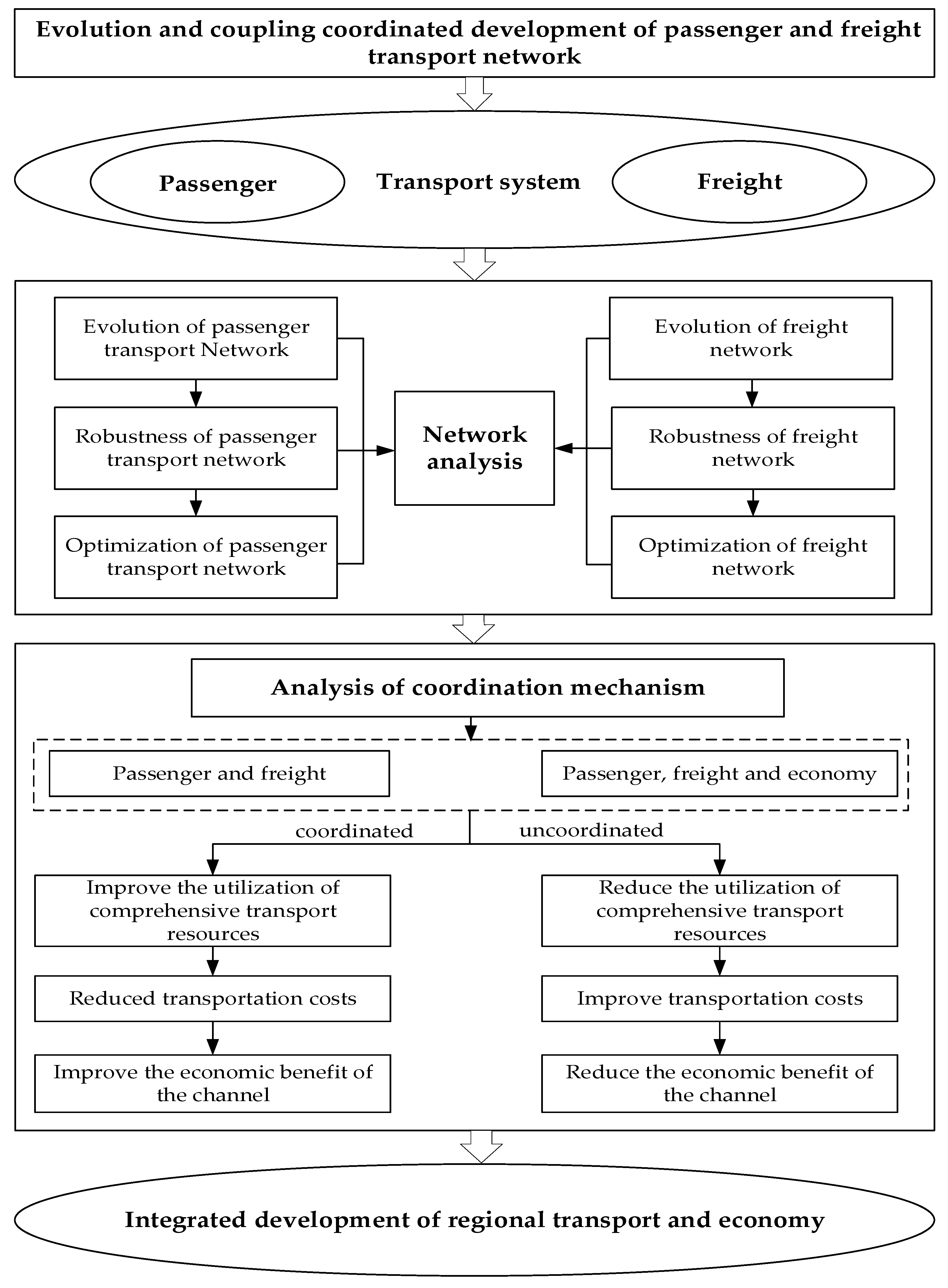
In view of this, this paper constructs a comprehensive network structure analysis model to discuss the evolution and coupling and the coordinated development of the passenger transportation and logistics network of the New Western Land-Sea Corridor. According to the four important time turning points in the development process of western China, the cross-sectional data of 2000, 2006, 2012, and 2018 are selected. It selects passenger volume and freight volume and uses a gravity model to measure the correlation strength of passenger and freight transportation and establishes the urban passenger and freight transport network. A disturbance model was used to analyze the variation of the resilience of passenger and freight transport networks and put forward the corresponding strengthening strategies. It uses the network growth method to optimize its passenger and freight network. Finally, the coupling coordination model is used to discuss the coordinated development of passenger transport and logistics in order to provide support for the construction of the comprehensive transportation system of the New Western Land-Sea Corridor and the development of regional development potential, so as to provide a certain reference for the implementation of the western development strategy in the new era. To show the contents of this study more clearly, the research framework of this paper is shown in
Figure 1.
3. Data Sources and Research Methods
3.1. The Data Sources
The calculation of urban passenger and freight transport correlation strength involved passenger volume, freight volume, and geographical distance between cities, among which passenger volume and freight volume are derived from the statistical yearbook of 12 provinces, municipalities, and autonomous regions involved in the New Western Land-Sea Corridor in 2000, 2006, 2012, and 2018 (
http://www.stats.gov.cn, accessed on 18 May 2022). Passenger and freight volumes included rail, road, water, and air. The statistical unit of passenger volume was ten thousand person–time, and the statistical unit of freight volume was ten thousand tons. The geographical distance between cities was calculated using network analysis tools in ArcGIS 10.7 (
https://desktop.arcgis.com, accessed on 10 June 2022). The map used in this article came from the resources and environmental science and data center of the Chinese Academy of Sciences (
http://www.resdc.cn, accessed on 16 March 2022).
3.2. Research Methodology
3.2.1. Network Construction
The gravity model was applied here; then, the passenger volume, freight volume, and transportation network distance were selected for the measurement of urban correlation strength
R, and the formula is as follows [
40]:
where
R represents the correlation strength of passenger and freight transportation between two different cities;
ci and
cj represent the passenger volume and freight volume of city
i and city
j, respectively. As urban centrality is the only indicator of city size,
a =
b = 1 can be assumed. This model was mainly used to measure the correlation strength between two cities, so
p can be treated as a constant 1, and
r is the distance attenuation coefficient; referring to other relevant studies, we chose
r = 2 [
41]. Further,
dij represents the distance of the transportation network between city
i and
j; it can be measured by the length of the transportation network between cities according to the high-speed, national, and provincial roads of the 12 provinces covered by the New Western Land-Sea Corridor in each year using network analysis tools in ArcGIS. Based on this, the urban passenger and freight transport network of New Western Land-Sea Corridor is constructed by the urban correlation strength
R.
3.2.2. Network Characteristic Measurement Method
The degree and degree cumulative probability distribution are often used to explore the distribution law of the urban network. The number of edges that other nodes connect to node
i is called the degree value of node
i and is generally expressed by
Di. If the degree value of a node is
k, then
ki is used to represent the set of all nodes with the degree value of
k, and the number of nodes in this set is represented by
nk. Since this paper only considers directed networks,
N is the total number of nodes whose degree is greater than 0. To sum up, the probability that the node degree of the network is
k is denoted as
p(
k), and the formula is as follows:
3.2.3. Disturbance Model
The disturbance model was conducted on the urban network using Python to analyze the variation characteristics of the network structure resilience, and the strengthening strategy of urban network resilience was proposed.
In an urban network, the stronger the connection between nodes is, the greater the reliability will be when dealing with network shocks, which means that it is easier to make corresponding adjustments and reduce the damage caused by disturbance. According to the classical definitions, the network resilience can be defined as follows:
where
R(
e) represents network resilience and 0 ≤
R(
e) ≤ 1; where ∑
degree0 represents the initial total degree of the network, and ∑
degree represents the total degree of the network after the attack, which can be used to measure the ability of the urban network to withstand damage and continue to operate.
Generally, interruption simulation is based on five common failure strategies. The first strategy is called node-degree-value-based disturbance strategy. In this strategy, target nodes are selected in descending order according to the degree of nodes, the network with the highest degree of nodes is attacked, the node with the highest degree of nodes is removed from the network, and then the network robustness after the removal of nodes is calculated. Finally, the variation of network characteristics before and after the attack is obtained, that is, the R(e) value. The second method is based on node random elimination strategy. As the name implies, this strategy is to randomly select a network node, remove the node from the network, calculate the network robustness after the removal, and then obtain the change value of network robustness. The third strategy is called edge-based random disturbance strategy. Different from the second strategy, the third strategy no longer starts from the point of view but randomly selects an edge in the network to remove, calculates its network robustness, and finally obtains the changed value. The fourth strategy is similar to the fifth one, but has a different state based on the network. It can be divided into a static network betweenness centrality disturbance strategy and a dynamic network betweenness centrality disturbance strategy. Both strategies start from the node with the highest betweenness centrality in the network then remove the target node from the network, and, finally, they calculate the network robustness to obtain its variation. The dynamic network node betweenness centrality will be changed while the nodes were removed, so it will be different from the static network. The dynamic network each time shall be recalculated and finally get a different network robustness value.
3.2.4. Network Growth Optimization Model
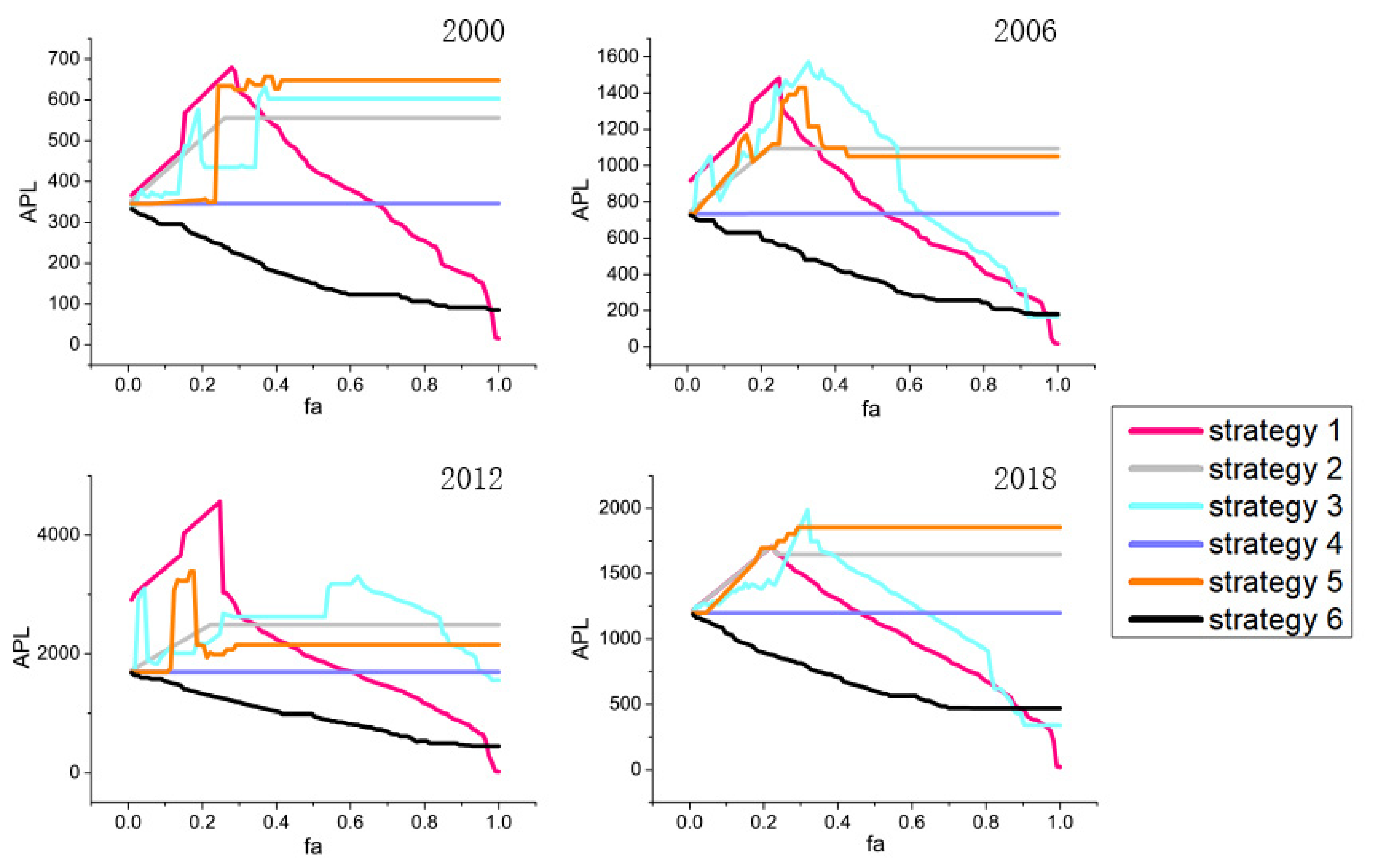
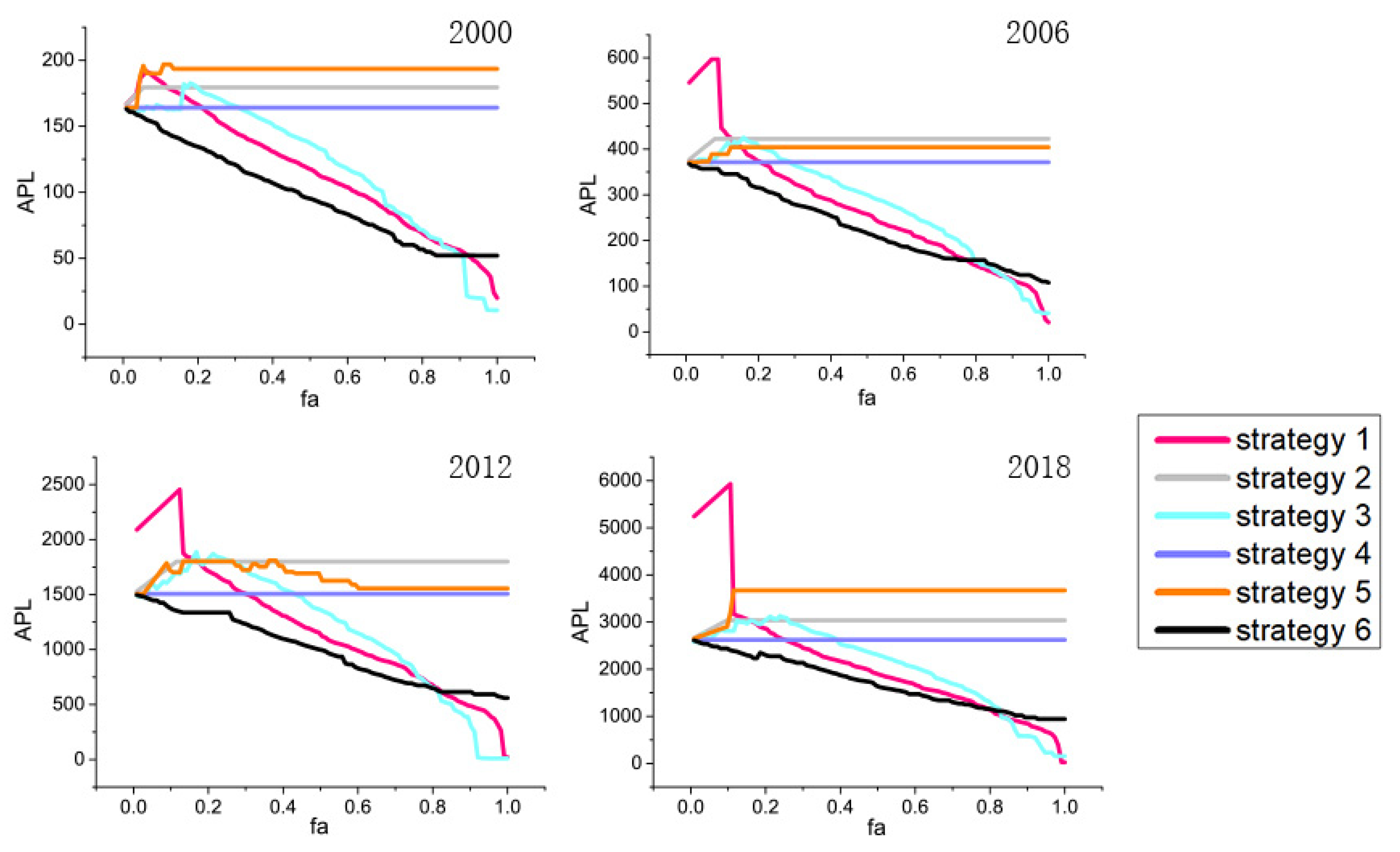
The research on network growth optimization is based on the following indicators, including average path length, degree value, betweenness centrality, clustering coefficient, closeness centrality, etc. The definition of network extension capability can usually be expressed as:
Ai represents the network expansion capability. As the desired number of nodes m increases, the network keeps a particular feature constant and minimizes the value. D stands for network diameter, which is the largest of all calculated path lengths and is a widely used indicator.
These commonly used six kinds of optimization strategies are connect the node pair have the maximum shortest path length (strategy 1), connect the node pair with the minimum multiplied degree value (strategy 2), connect node pairs with smallest betweenness value (strategy 3), connect the node pair with minimum degree value (strategy 4), connect the node pair with smallest clustering coefficient (strategy 5), and connect the node pair with minimum closeness centrality (strategy 6).
3.2.5. Coupling Coordination Model
The coupling degree is an important index used to measure the degree of interaction between two or more elements in a system. Due to the large difference of the selected indicators, the data was standardized and calculated with the coupling degree formula.
Here,
C is the coupling degree;
U1 and
U2 represent the values of passenger transport and freight transport, respectively (after the total amount of correlation strength is standardized). In special cases, coupling degree has difficulty reflecting the overall degree and synergistic effect of regional accessibility and economic connection strength. Indicators for different cities all have dynamic, staggered, and uncoordinated characteristics, and there may be errors in evaluating synergies only based on the coupling degree. Therefore, the coupling coordination degree model is further applied, and the formula is as follows:
D is the coupling coordination degree, and D ∈ (0,1). T is the harmonic coefficient of passenger and freight transportation correlation strength, reflecting their contribution level to the coupling coordination degree. The values x and y represent the weights of the passenger and freight transportation correlation strength, respectively; x + y = 1 and its value can be calculated with the entropy weight method.
3.3. Research Area
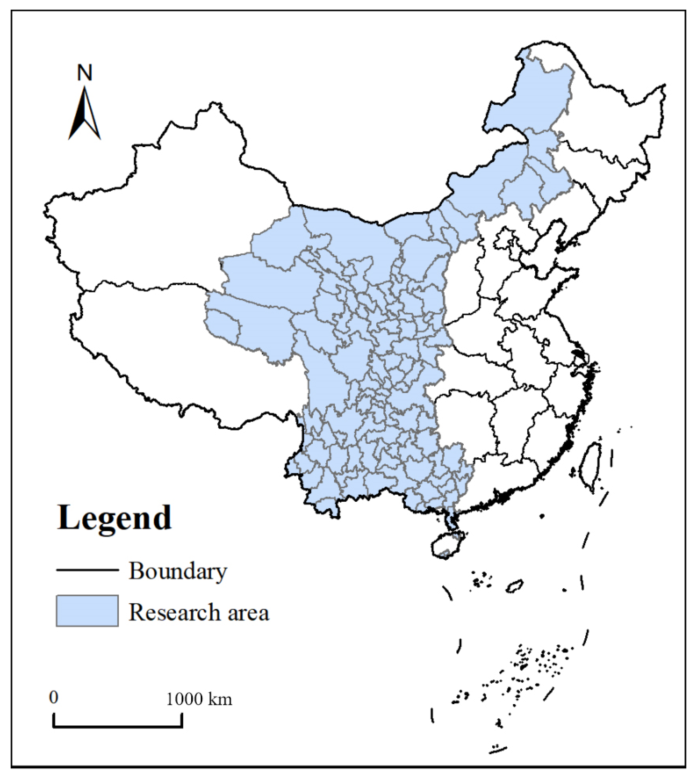
Since it is difficult to collect the data of specific prefecture-level cities in Xinjiang, Tibet and Hainan, the research scope of this paper only includes 113 prefecture-level cities in 12 regions of Chongqing, Guangxi, Guizhou, Gansu, Qinghai, Yunnan, Ningxia, Shaanxi, Sichuan, Inner Mongolia, Hainan, and Guangzhou. The research area is shown in
Figure 2. The provincial and municipal administrative boundaries are derived from the Resource Environment Science and Data Center (
https://www.resdc.cn, accessed on 16 March 2022).
4. The Interaction between Passenger Transport and Freight Transport
The New Western Land-Sea Corridor is the main artery of freight transportation from western China to Southeast Asia and even the world, injecting new momentum into the formation of the new development pattern of domestic and international double circulation. The corridor promotes large circulation, gathers large industries, promotes emerging industrial chains, and strengthens inter-regional and international linkages. In the development of logistics transportation, passenger flow transportation cannot be ignored. The construction of channels not only accelerates the formation of the logistics network, but also further promotes the development of urban agglomeration. Therefore, the development of passenger flow and logistics is very important in the construction of the New Western Land-Sea Corridor.
In recent years, China has made great efforts for the development of infrastructure; the rapid development of transport infrastructure can not only optimize the transportation structure and industrial structure, but also can have a significant impact on the logistics market, which can provide more development opportunities for logistics enterprises, accelerate the formation of a new pattern of market competition, and give full play to their technical and economic characteristics. Further, it can make full use of excess passenger transport capacity, reduce costs and resource investment, and expand new ways of logistics transportation. The integration of passenger transport into freight transport can play to its advantages in resources, management, and cost while goods transportation can effectively integrate passenger transport enterprises and break the professional and regional boundaries. The coordinated development of these two systems will be conducive to the construction and improvement of the comprehensive transport system.
Logistics is the abbreviation of “material flow” or “goods transportation”. Passenger transportation and goods transportation belong to the scope of logistics activities. The freight transportation promoting effect on passenger transportation can be divided into the following several aspects; first, the goods transport supply chain provides clients with comprehensive systemic services, reducing the circulation of passenger transport costs. Second, it can effectively promote the reasonable division of labor and coordinated development among regions to optimize the industrial structure. Third, it can improve the utilization rate of idle passenger transport resources. Fourth, it can share the operation risk of passenger transport companies, improving the enterprise’s own ability to resist risk.
The logistics transport and passenger transport promote each other and develop together. Therefore, the coordination between the two is particularly important in the integrated transportation system. If the passenger transport and freight transport are not coordinated, the comprehensive transport efficiency will be reduced, the transport cost will be higher, and the economic benefit of the channel cannot be maximized. If the passenger transport and freight transport are coordinated, comprehensive transport efficiency will be improved, transport costs will be reduced, and economic and efficient development of corridors will be promoted. To sum up, road passenger transport integrated into logistics can play to their resources, management, and cost advantages. The logistics transport can effectively integrate road passenger transport enterprises and break professional and regional boundaries. The coordinated development of the two will be conducive to the establishment and perfection of the comprehensive transportation system and strengthen the economic radiation capacity of the channel.
5. Evolution of Passenger and Freight Transportation Network
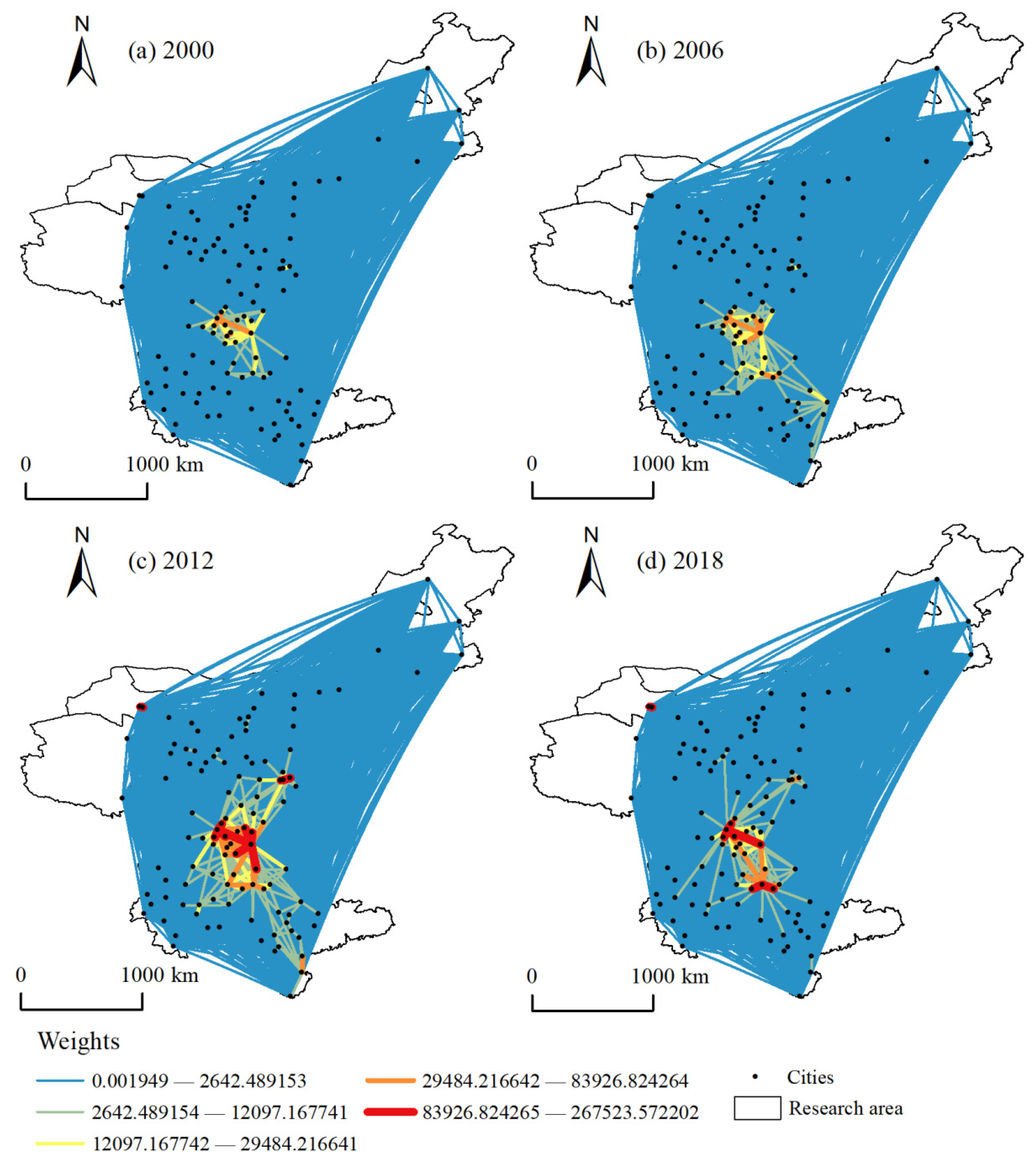
The evolution of the urban passenger flow network in each year is shown in
Figure 3. In 2000, the second highest value areas were located in Chengdu and Chongqing, while the higher value regions were located in Sichuan province, Xi’an, Guiyang, Zunyi, and other cities, forming a passenger flow network structure dominated by Southwest China. In 2006, areas like Luzhou, Nanchong, Guang’an, Guiyang, Qiannan, and Qiandongnan had stronger passenger flow network correlation strength, and the sub-high value region gradually expanded. Meanwhile, Guizhou and Guangxi province had stronger overall correlation strength and gradually formed a spatial pattern of passenger flow network with Chengdu-Chongqing urban agglomeration as the center and Xi’an and Guiyang as the sub-centers. In 2012, the correlation strength of Chengdu, Meishan, Luzhou, Nanchong, Guang’an, Chongqing, Xi’an, Zunyi, and other regions further enhanced; located in the high-value area, the second-highest value area migrated to Chengdu-Chongqing urban agglomeration, Central Guizhou urban agglomeration, Zhanjiang, and Haikou. The higher-value area gradually expanded, extending to Guanzhong urban agglomeration. In 2018, the main high value area was located in Chengdu, Chongqing, Guiyang, and the second-highest value was located in Chengdu-Chongqing urban agglomeration, Central Guizhou urban agglomeration, and Xi’an. A higher value is moving to Yunnan; further models show a passenger flow network spatial pattern with Chengdu, Chongqing, and Guiyang as the main centers and Chengdu-Chongqing urban agglomeration, Central Guizhou urban agglomeration, and Guanzhong urban agglomeration as the sub centers.
What forces are driving the evolution of this passenger network? The development of the passenger flow network is inseparable from economic, political, population growth, and other factors. It is these factors that gradually promote the development of urban agglomeration, and the development of urban agglomeration further affects the population flow.
In order to transfer the surplus economic development capacity of the eastern coastal areas to the western region, so as to improve its economic development level, the State Council put forward the western development policy in 2000. During this period, most of them focused on the basic needs of the people and were in the stage of infrastructure construction. The gross domestic product (GDP) and resident population of Chengdu and Chongqing were in the forefront. In 2006, the State Council, through the Development of the West “eleven-five” plan, sped up the economic development of the western region. At this time, the western region was in a slow growth stage, and the GDP of Chongqing and Chengdu were still in first and second place. However, the resident population of Chongqing decreased, the resident population of Chengdu increased, and the GDP of Xi’an and Guiyang increased significantly. In 2012, the State Council approved the “12th Five Year Plan” for the development of the western region, which made overall planning for the spatial development pattern of the western region, and it supported 11 key economic zones such as Chengdu Chongqing Economic Zone, Guanzhong Tianshui, and Guangxi Beibu Gulf to take the lead in development and 8 resource rich zones such as Panxi Liupanshui to develop intensively. The development of the border open areas was accelerated. At this time, the economy of the western region was in a rapid growth stage. The proposal of the “the Belt and Road” initiative in 2013 has brought new opportunities for the development of the western region. Meanwhile, the State Council has further refined and improved the policies for the large-scale development of the western region, with emphasis on infrastructure construction, the development of characteristic and advantageous industries, the construction of ecological civilization, the improvement of people’s livelihood, and deepening the reform and opening up. In 2016, the State Council approved the development plan of Chengdu Chongqing urban agglomeration, which proposed to cultivate and develop Chengdu Chongqing urban agglomeration with Chongqing and Chengdu as the center, and integrate into the “Belt and Road”, the development of the Yangtze River economic belt and the new round of western development. With the continuous expansion of the cooperation scope of the “southbound channel”, the new land and sea channel in the western region was officially put forward in 2019, which greatly saved the international transportation time and cost, greatly released the vitality of internal and external opening, and further promoted the leap forward in the development of the western region.
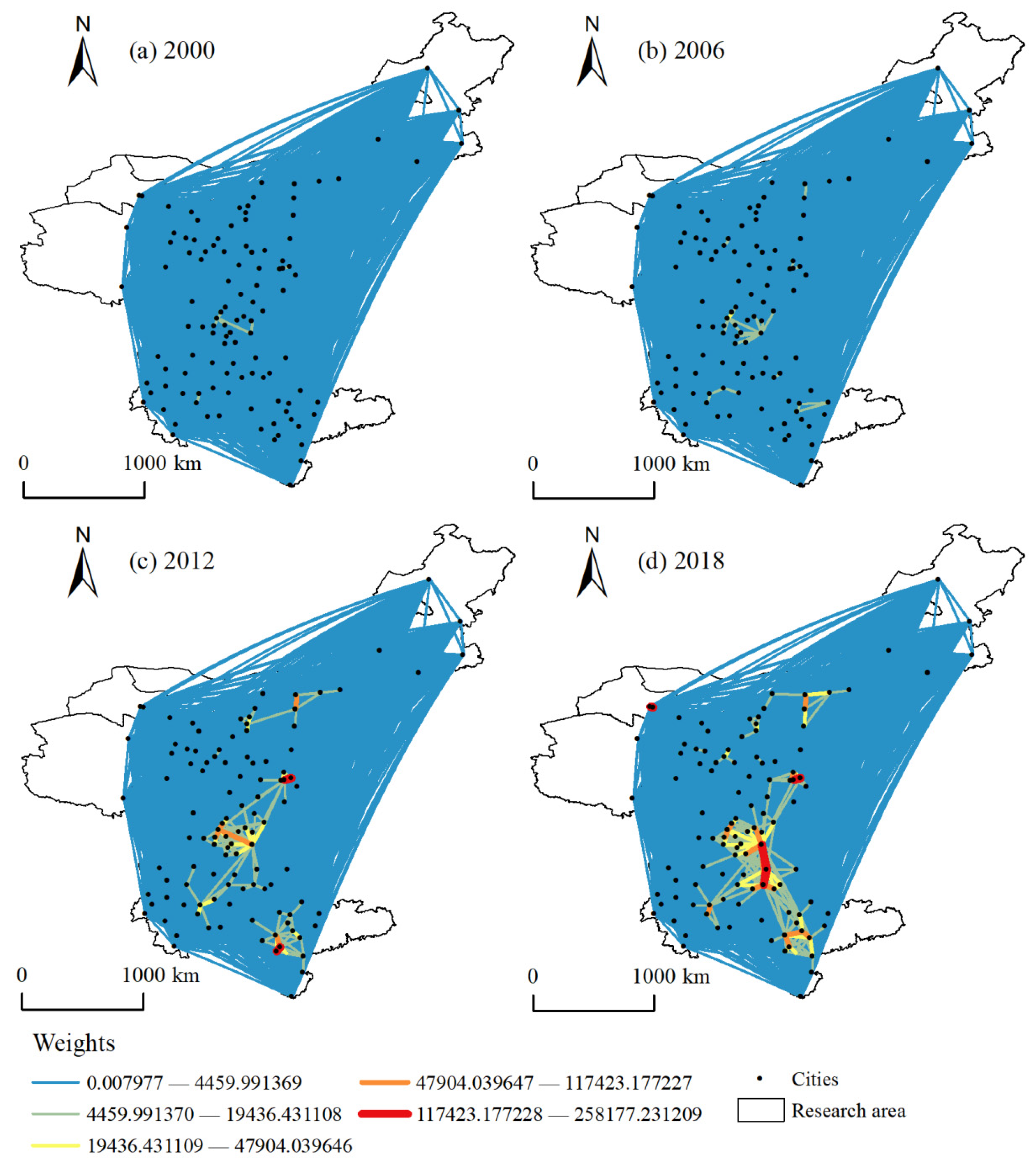
The evolution of the urban freight network in each year is shown in
Figure 4. In 2000, the overall correlation strength of freight network was comparatively weak, and the spatial structure was formed with Chengdu and Chongqing as the centers and Xi’an as the sub-center gradually became prominent. In 2006, the entire network connection strength increased, mainly reflected in Chengdu-Chongqing urban agglomeration, Baotou, Ordos, Kunming, Qujing, Qianxinan, Liuzhou, Hezhou, Laibin, and other regions, treat Chengdu-Chongqing urban agglomeration as the center and formed the spatial pattern with Tongchuan, Xi’an, Weinan, Baotou, ordos, Kunming—Qujing—Qianxinan, and Liuzhou-Hezhou-Laibin as vice centers. In 2012, the network connection was further strengthened; higher values were mainly distributed in Chengdu, Chongqing, Xi’an, Deyang, Meishan, Nanning, Qinzhou, Fangchenggang, Baotou and Ordos; higher values were allocated in Dazhou, Nanchong, Luzhou, Neijiang, Kunming, Qujing, and Yuxi; and it shaped Chengdu-Chongqing urban agglomeration as the center and the network spatial pattern of Xi’an, Nanning, Kunming, and Ordos as sub-centers. In 2018, the correlation strength of Chongqing, Guiyang, Zunyi, Luzhou, Nanchong, Kunming, Nanning, and Yulin was further reinforced; the high-value areas shifted to Chongqing, Zunyi and Guiyang; and the sub high-value areas spread to Luzhou, Nanchong, Anshun, Qiannan, Guigang, Yulin, Kunming, and Yuxi. The high-value areas were mainly concentrated in Sichuan province, Guizhou province, Guangxi province, and Inner Mongolia, and they form a network space pattern with Chengdu-Chongqing urban agglomeration as the center and Guiyang, Xi’an, Kunming, Nanning, and Ordos as the sub-centers.
From 2000 to 2018, the logistics network has realized the spatial pattern evolution of “two masters and one deputy” to “one master and multiple deputy”. In addition to the factors affecting the evolution of the passenger flow network, the evolution of the logistics network is inseparable from the construction of the traffic network.
In 2000, the density of the transport network in the western region was low at only 834.91 km/10,000 km2, which was only 53% of the national average and 18% of the eastern region. It has affected the optimization of resource allocation and seriously delayed the development of the western region. In 2006, the Qinghai-Tibet Railway was officially completed and opened to traffic. The construction of national trunk lines and inter provincial channels for the development of the western region was basically completed. The total length of highways in the western region exceeded 940,000 km, and substantial progress was made in the construction of a comprehensive transportation system. In 2012, the rapid development of China’s railway construction accelerated the implementation of passenger and freight line transport, which greatly improved the freight capacity of the railway. In 2013, a number of railways were opened in Guangxi, realizing effective connections between Nanning, Qinzhou, Fangchenggang, Liuzhou, Beihai, Liuzhou, Maoming, and Zhanjiang. In 2014, several lines were opened in Southwest China, and the Lanzhou-Wulumuqi high-speed railway was also opened one after another. In 2015, the opening of the Lanzhou-Chongqing railway has realized the effective connection between southwest and northwest regions, and the opening of the Chengdu-Chongqing high-speed railway has accelerated the efficient development of the Chengdu-Chongqing region. In 2016, Kunming expanded its connections with cities in neighboring provinces, opening high-speed rail lines to Guiyang and Baise as well as an intercity railway to Yuxi. The Nanning-Kunming high-speed railway was opened successively, which was an important railway channel connecting Southwest China and South China and a “golden corridor” for Southwest China to go to sea. Subsequently, the Baoji-Lanzhou and Xi’an-Chengdu high-speed railway were officially opened. The construction of the comprehensive transportation network shortened the transportation time, reduced the transportation cost, and greatly improved the efficiency of the logistics transportation system.
The evolution of the passenger transport network is closely related to the evolution of the logistics network, both of which are influenced by economics, transportation, population growth, politics, and other factors. In the process of development, the two networks influence and promote each other, but there are some differences. The evolution of the passenger transport network can also be regarded as the evolution of population flow, which is more affected by population growth, economic development level, and political factors, which are also important growth points for the development of urban agglomeration. Therefore, the evolution of the passenger transport network is more inclined to the spatial development pattern of urban agglomeration. However, the logistics network is actually a product transportation network, which is affected more by transportation routes and industrial chains, so the evolution of the logistics network is more inclined to the spatial pattern of the transportation network.
6. The Network Robustness and Optimization of Two Networks
6.1. The Network Robustness of Two Networks
Here, we separate the networks as the whole network, which include all of the nodes, and the key network, which only contains the nodes that have larger connections than the average level. The study of the whole networks offers a complete picture of the networks, and the research of the key networks can better catch the important performance of these key nodes.
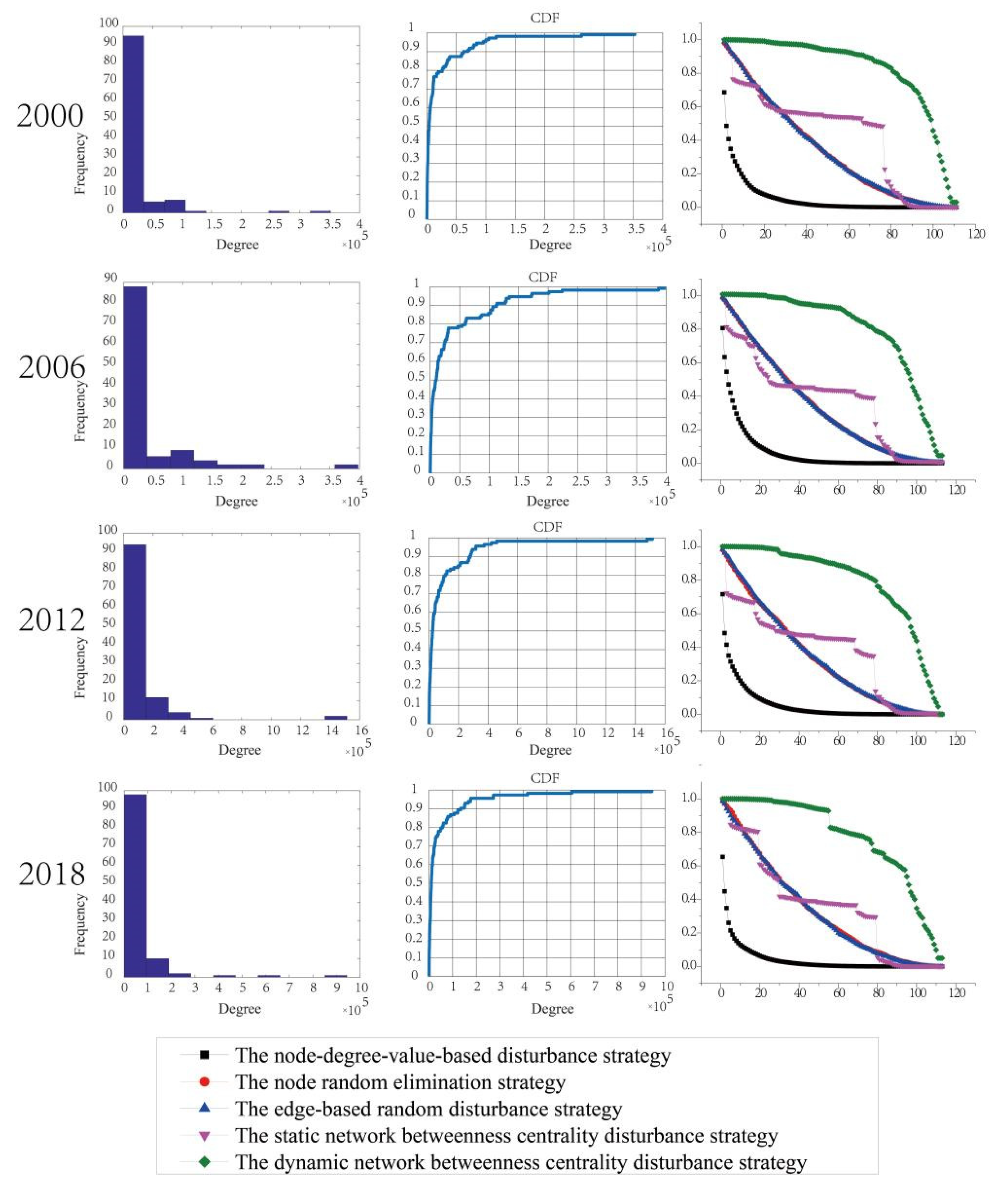
The cumulative degree distribution and network resilience of the whole network of urban passenger transport of 2000, 2006, 2012, and 2018 was analyzed (as shown in
Figure 5). The network resilience of the whole network of passenger transport in different periods was altered. With the simulation of the total network disturbance of urban passenger transport in four different years, the disturbance caused by the node degree value strategy is most obvious for the total network, in which 10% of the nodes were removed and the network resilience decreased by around 90%. The impact of these two random strategies is relatively stable in these networks. When 10% of the nodes were removed, the network resilience decreased by about 20%. For the whole passenger transport network in 2000, when 20% of nodes were removed, the network’s resilience decreased by about 45%. If the nodes were removed further, the impact would have been less than that of the two random disturbance strategies. However, when 75% nodes were removed, the network’s resilience decreased by about 95%. The influence would be greater than that of the two random disturbance strategies. For the whole passenger transport network in 2006, when 30% nodes were removed, the network resilience decreased by about 55%, and the impact was the same as that of the two random strategies. When the node removal was between 30% and 85%, its effect was less than that of the two random disturbance strategies. When the node removal was greater than 85%, the degree of influence would be slightly greater than that of the two random disturbance strategies. For 2012, when 30% of the nodes were removed, the network resilience decreased by about 50%; when 30–80% of the nodes are removed, its impact is less than that of the two random disturbance strategies; when more than 80% of the nodes are removed, the influence is slightly greater than that of the two random disturbance strategies. With the analysis of the passenger transport network in 2018, when 10% of the nodes were removed, the network resilience decreased by about 20%; when 10–17% of nodes were removed, the impact degree was less than that of the two random strategies; when 17–35% of the nodes were removed, the shock was greater than that of the two random disturbance strategies; when 35–70% of the nodes were removed, the degree of influence was smaller than that of the two random disturbance strategies. When the node removal was greater than 75%, the degree of influence was slightly larger than that of the two random disturbance strategies. The dynamic betweenness disturbance strategy was relatively stable and has the least influence among the five strategies. Compared with the other three years of urban networks, the whole passenger transport network showed a discontinuous decline in 2018.
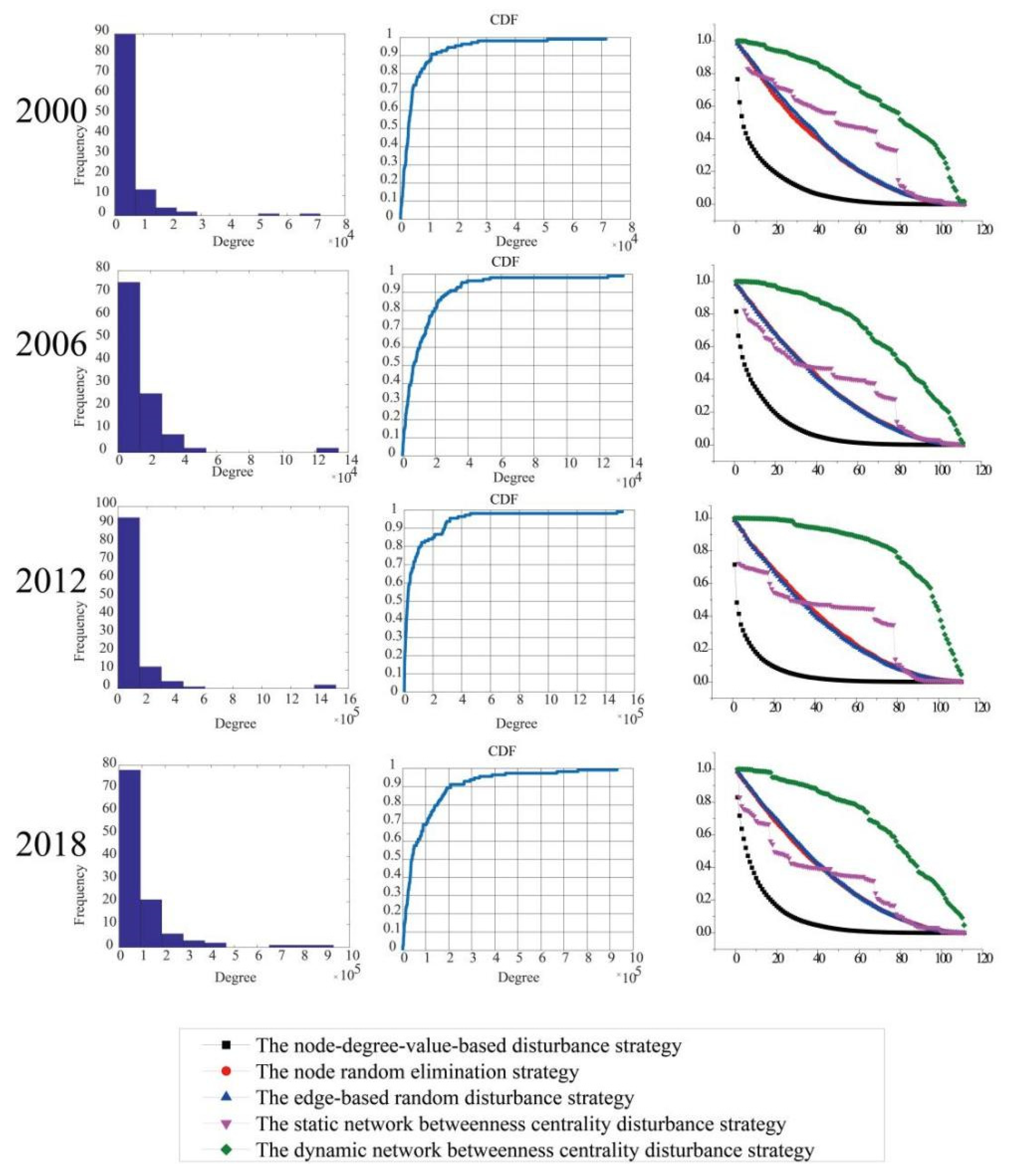
The accumulative degree distribution and network resilience of the whole urban freight transport network of 2000, 2006, 2012, and 2018 was then further analyzed (as shown in
Figure 6). The network resilience of the whole freight transport network in different periods was dissimilar. With the simulation of the total network disturbance of urban passenger transport in four different years, the node degree value-based strategy has the greatest influence on the total network. When 10% of the nodes were removed, the network resilience decreased by about 75%. The same two random strategies are relatively stable; when 10% of the nodes were removed, the network efficiency only decreased by about 20%. Based on the static betweenness disturbance strategy of the whole freight transport network in 2000, when 13% of the nodes were removed, the network resilience only decreased by about 15%. If the nodes continue to be removed, the impact will be less than that of the two random disturbance strategies. However, when 75% of the nodes were removed, the network resilience decreased by about 95%, and the impact would be the same as that of the two random disturbance strategies. For the whole freight transport network in 2006, when 30% of the nodes were removed, the network resilience decreased by about 55%, and the impact was the same as that of the two random disturbance strategies. When the node removal was between 30% and 75%, the impact was less than that of the two random disturbance strategies. When the node removal was greater than 75%, the degree of influence was the same as that of the two random disturbance strategies. For the freight transport network in 2012, when 30% of the nodes were removed, the network resilience decreased by about 55%; when 30–73% of the nodes were removed, the impact degree was less than that of the two random disturbance strategies; when more than 73% nodes were removed, the impact was similar to the two random disturbance strategies. For 2018, when 40% of the nodes were removed, the network resilience decreased by about 65%; when 40–68% of the nodes were removed, the impact grade was less than that of the two random disturbance strategies; when more than 68% of the nodes were removed, the influence was nearly the same as that of the two random disturbance strategies. The dynamic betweenness disturbance strategy was relatively stable and had the least influence among the five strategies. Compared with the other three years, the freight transportation network had the least influence in 2012.
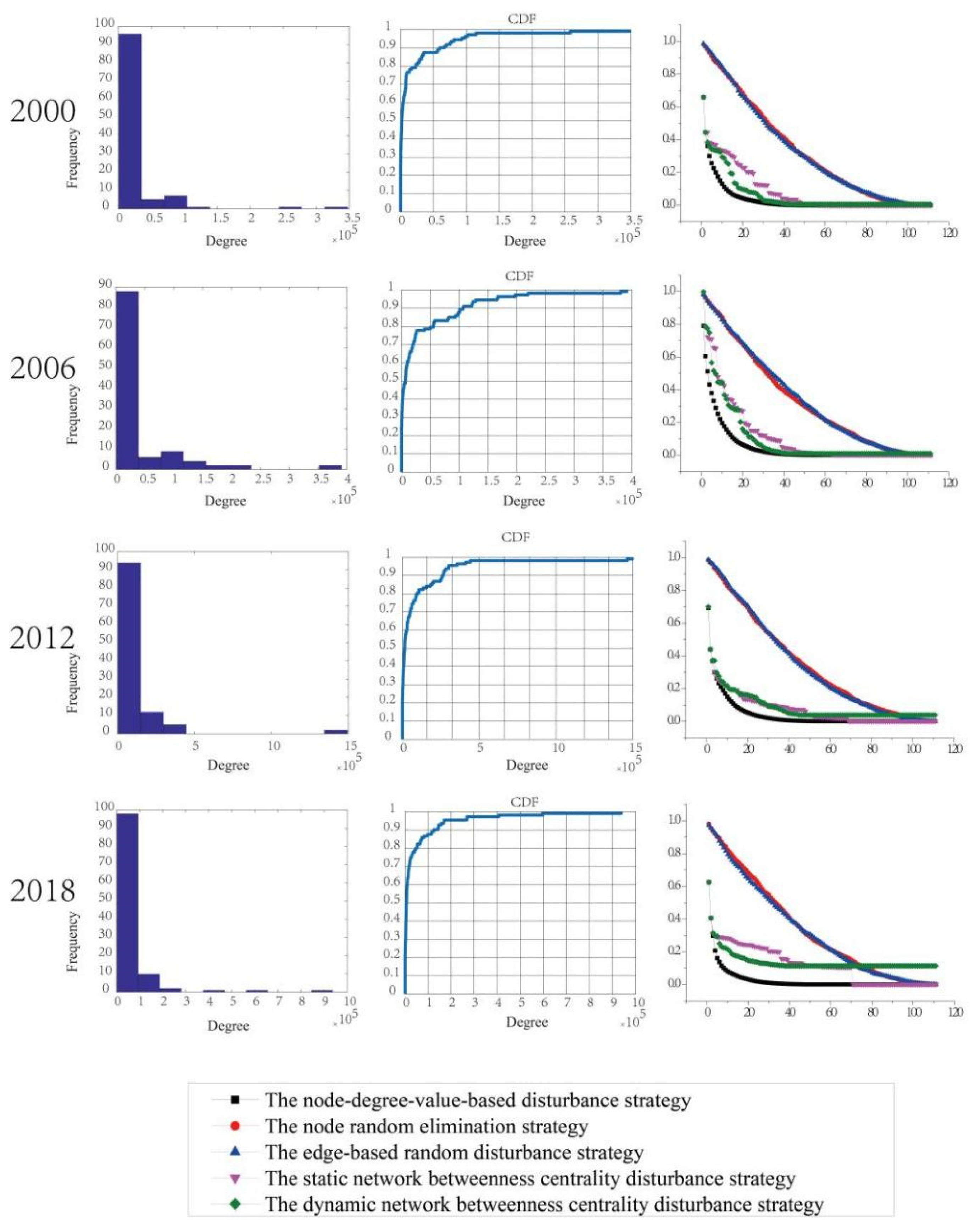
The accumulative degree distribution of the key urban passenger transport network of 2000, 2006, 2012, and 2018 was then further analyzed (
Figure 7). The network resilience of key passenger transport network in different periods was changed. With the simulation of four major urban passenger transport network outages in different years, the node degree value-based strategy had the largest degree of interference to the key network. When 10% of the nodes were removed, the network resilience decreased by about 95%. The two random strategies were relatively stable and had the least influence in the key network. In 2000 and 2006, the influence degree based on the static betweenness disturbance strategy was always greater than or equal to that based on the dynamic betweenness disturbance strategy. For the key passenger transport networks in 2012, when the nodes were removed from 0% to 40%, the influence degree of the two betweenness disturbance strategies was the same, but when the nodes were removed from 40%, the influence degree of the dynamic betweenness disturbance strategy was slightly greater than that of the static strategy. In 2018, when the removal of the nodes was less than 35%, the influence degree based on the static betweenness disturbance strategy was always greater than that based on the dynamic mediating disturbance strategy. When over 35% of the nodes were removed, the influence degrees of the two betweenness disturbance strategies were consistent and the network was mainly damaged. However, when the removal of the nodes was greater than 60%, based on the static betweenness disturbance strategy, the network ability was suddenly reduced to 0%.
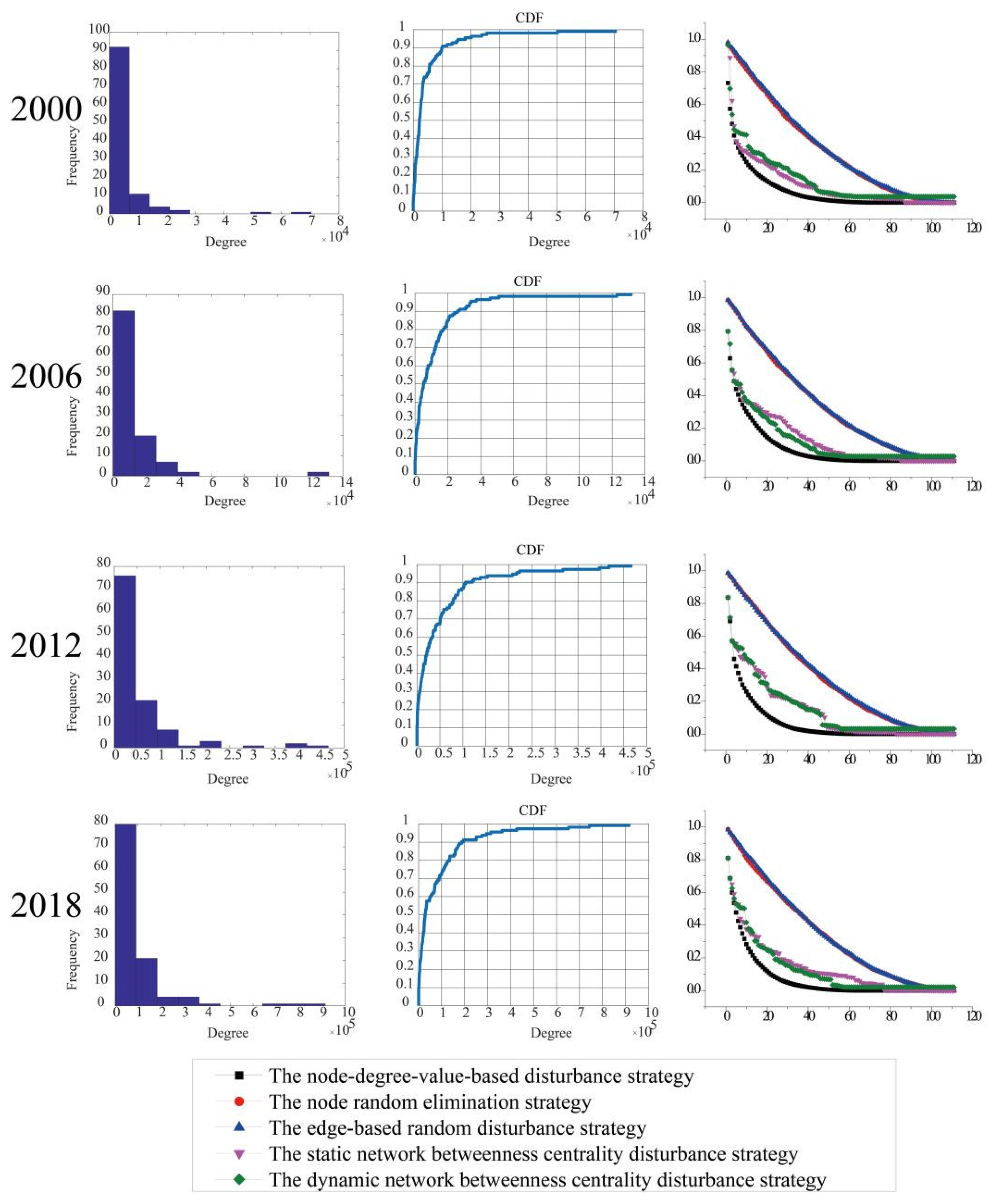
The accumulative degree distribution of the key urban freight transport network of 2000, 2006, 2012, and 2018 was also analyzed (
Figure 8). It works similarly to the key urban passenger transport network. In the simulation of four major urban freight transport network outages in different years, the node degree value-based strategy had the largest influence of interference to the major network, and when 10% of the nodes were removed, the network resilience decreased by about 85%. Similar to the key passenger transport network, the two random strategies were relatively stable and had the least influence in the key network; when 10% of the nodes were removed, the network resilience decreased by about 20%. In 2000, the influence of the static betweenness disturbance strategy was greater than that of the dynamic betweenness disturbance strategy. However, in 2006, the influence of the static betweenness disturbance strategy was less than that of the dynamic betweenness disturbance strategy, which is contrary to that of 2000. In the key passenger transport networks in 2012, the influence degree of the two betweenness disturbance strategies were basically the same. In the key passenger transport network in 2018, when the removal of the nodes was less than 20%, the influence of the two betweenness disturbance strategies was quite the same, but when the removal of the nodes was more than 20%, the influence of the dynamic betweenness disturbance strategy was slightly greater than the static betweenness disturbance strategy.
6.2. Network Optimization
Six commonly used optimization strategies were adopted to simulate and analyze the growth of passenger transportation and freight transportation network in the New Western Land-sea Corridor in four years, and the results are shown in
Figure 9 and
Figure 10.
The passenger network has a strong network expansion ability. In the four-year period, strategy 6 was the best optimization strategy and strategy 1 had the second-best optimization effect while strategy 2, strategy 3, and strategy 5 had no optimization effect and strategy 4 always kept APL at its initial value. In 2000, when the number of network nodes increased by 70%, strategy 1 made the network APL equal to the initial value; strategy 6 made the APL decrease; and strategy 2, 3, and 5 made the network APL increase. In 2006, when the number of network nodes increased by 55%, strategy 1 made the network APL equal to the initial value, strategy 6 made the APL decrease, and strategy 2 and strategy 5 made the network APL increase. When the number of network nodes increased by 63%, strategy 3 made APL equal to the initial value. In 2012, when the number of network nodes increased by 60%, strategy 1 made the network APL equal to the initial value, strategy 6 made the APL decrease, and strategy 2 and strategy 5 made the network APL increase. In 2018, when the number of network nodes increased by 46%, strategy 1 made the network APL equal to the initial value, strategy 6 made the APL decrease, and strategy 2 and strategy 5 made the network APL increase. When the number of network nodes increased by 63%, strategy 3 made APL equal to the initial value.
The freight network has a strong network expansion ability. Strategy 6 has the best optimization effect, strategy 1 has the second-best optimization effect, strategy 3 has the third-best optimization effect, strategy 2 and strategy 5 increase the network APL value, and strategy 4 keeps the network APL value at the initial value. In 2000, when the number of nodes increased by 20%, the APL value of strategy 1 was equal to the initial value; the APL value of strategy 6 was less than the initial value; and the APL values of strategies 2, 3, and 5 were all greater than the initial value. In 2006, when the number of network nodes increased by 22%, the APL value of strategy 1 was equal to the initial value; the APL value of strategy 6 was less than the initial value; and the APL values of strategy 2, 3, and 5 were all greater than the initial value. In 2012, when the number of nodes increased by 30%, the APL value of policy 1 was equal to the initial value; the APL value of policy 6 was less than the initial value; and the APL values of policies 2, 3, and 5 were all greater than the initial value. When the number of nodes increased by 25% in 2018, the APL value of strategy 1 was equal to the initial value; the APL value of strategy 6 was less than the initial value; and the APL values of strategies 2, 3, and 5 were all greater than the initial value.
7. Study of the Evolution of Coupling Coordination Degree between Passenger Transport and Freight Transport
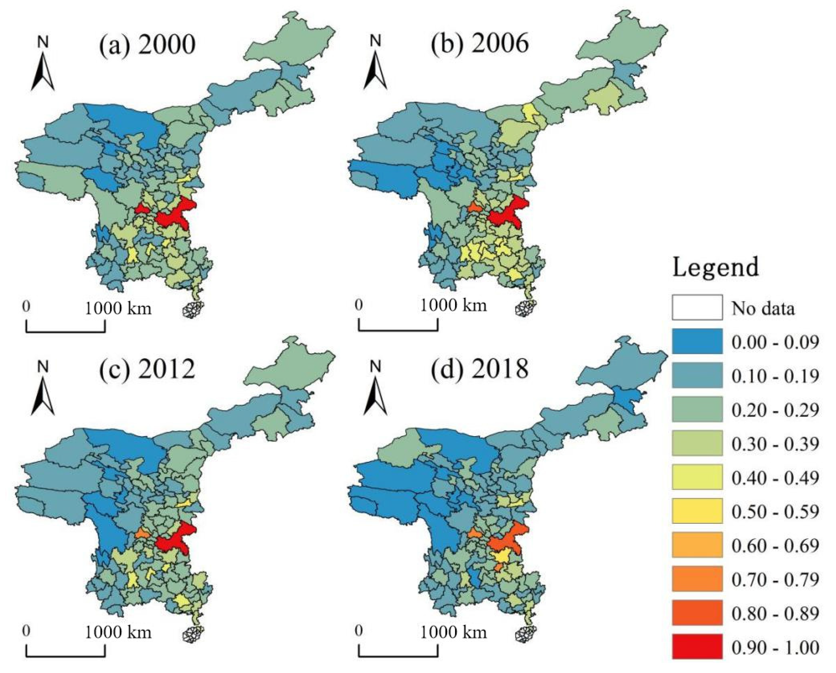
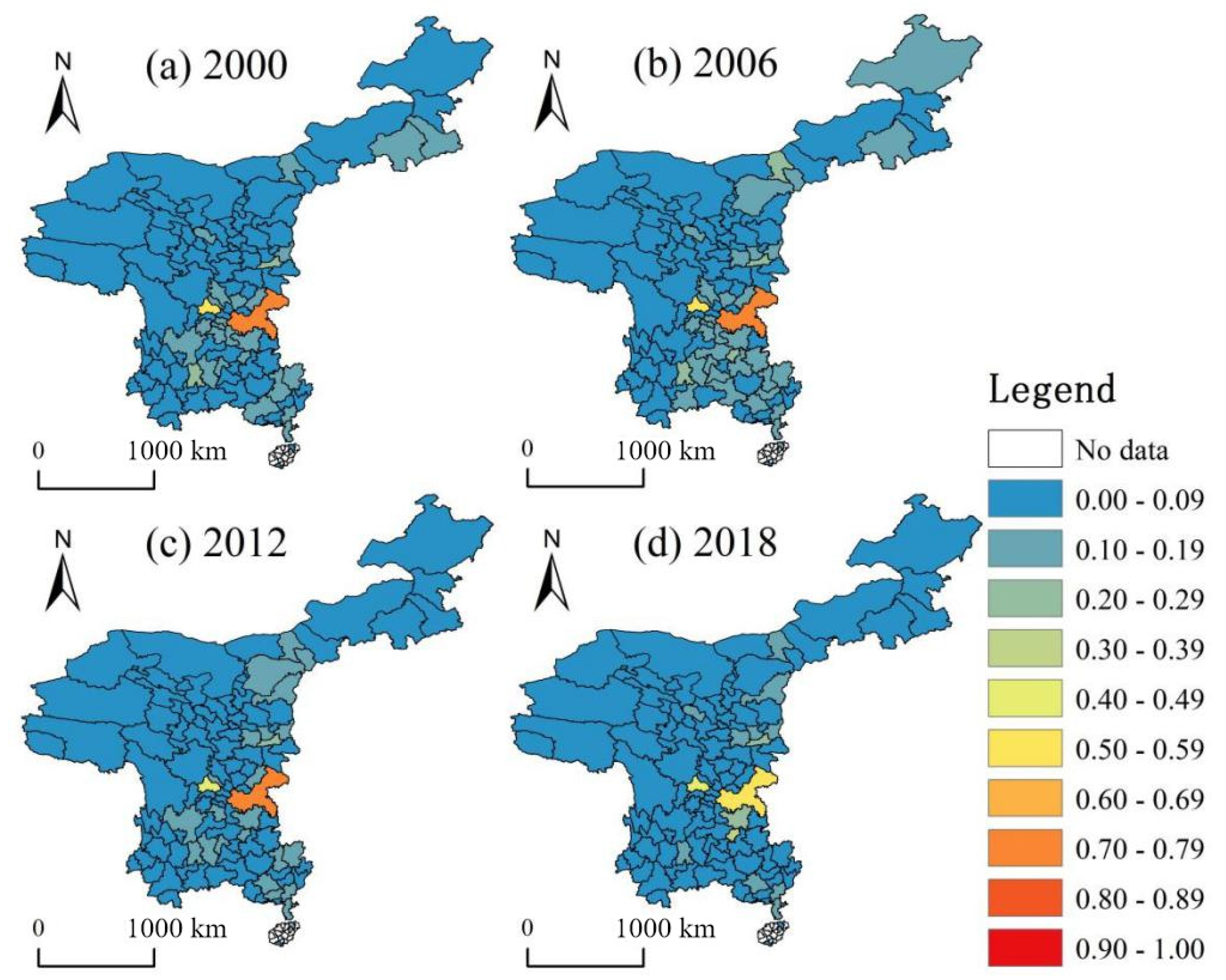
Based on the coupling coordination model, the coupling coordination degree of passenger transportation and freight transportation in the New Western Land-Sea Corridor in 2000, 2006, 2012, and 2018 was calculated respectively. By referring to the classification standard of the coupling coordination degree (
Table 1) [
42], the coupling coordination degree of the passenger transport and freight transport is divided into ten levels; that is, namely, extremely unbalanced, severely unbalanced, moderately unbalanced, mildly unbalanced, near unbalanced, barely coordinated, primary coordinated, medium-pole coordinated, good coordinated, and high-quality coordinated. The spatial distribution of the coupling coordination degree of the economy, passenger transport, and freight transport in four western new land-sea passage cities in different periods was obtained through characterization (
Figure 11 and
Figure 12).
In 2000, the economic level of the western region was low, and the transportation network was in the stage of infrastructure construction. As the industrial development in Southwest China gradually shifted from resource-based development to resource-based processing, freight transportation reduced its dependence on the railway. With the adjustment of industrial structure, the railway has changed the thought of “attaching importance to freight and neglecting passenger transport” for a long time to vigorously develop passenger transport. The level of coupling coordination between the passenger transport and freight transport was relatively low. Most cities were in mild or moderate disorder, and a few areas, such as Xi’an, Kunming, Liupanshui, and Guiyang were on the critical point of disorder. Chongqing and Chengdu were in a high coordination position. In 2006, the economy grew slowly, the main road of the transportation network was basically formed, and the population increased slightly. The coupling coordination level of the passenger transport and freight transport was improved, mainly reflected in Guizhou province, Guangxi province, and Inner Mongolia autonomous prefecture. The coupling coordination degree of Baotou, Qujing, Southwest Guizhou, South Guizhou, Nanning, and other regions gradually increased, which belongs to the type of near unbalanced. In addition, the level of coupling coordination in Chengdu has decreased, belonging to good coordination. In 2012, the economy of the western region grew rapidly, but the construction of the transportation network and population growth were slow. The freight capacity of the railway has been greatly improved while passenger transport has not achieved breakthrough development, which makes the coupling and coordination degree of the two declines, but Chongqing is still in high-quality coordination. In addition to the Xi’an coupling coordination degree rise, the Kunming, Nanning, Guiyang, and Liupanshui region coupling coordination level was in stable condition; therefore, it still belongs to the type on the verge of disorder. The coupling coordination degree of Chengdu was reduced from the good coordination to primary coordination level. In 2018, the economic level increased rapidly, the comprehensive transportation network was basically completed, and the western region gradually moved toward leapfrog development. Compared with logistics, the opening of the high-speed rail has promoted the development of passenger transportation more and the overall coupling coordination level decreased significantly; Chongqing was in a good coordination state, while the coupling coordination degree of Xi’an and Kunming were also decreased in the state of the borderline disorder and mild disorder, respectively. Chengdu was still in the primary coordination state, while the coupling coordination degree of Guiyang and Zunyi were increased to the primary coordination and barely coordination level, respectively.
The economic, logistics, and coupling coordination level of the overall passenger network is low, and the Chengdu and Chongqing coupling coordination level is relatively good. In 2000 and 2006, Chengdu and Chongqing were in the barely coordination and betweenness coordinate; in 2012, Chengdu went from barely coordination to borderline disorder. The coupling coordination level of Chongqing in 2018 dropped to barely coordination; however, Guiyang and Zunyi increased significantly and was in mild and moderate disorder, respectively.
8. Conclusions and Recommendations
8.1. Conclusions
With the evolution analysis of the four-year passenger transport network spatial pattern, we can see that the central area of passenger transport network diffuses from Chengdu and Chongqing to Chengdu Chongqing urban agglomeration. With the enhancement of the Central Guizho and Guanzhong urban agglomeration, it has finally realized the evolution of the spatial pattern of the passenger transport network from “two main cities and multiple auxiliary cities” (Chengdu and Chongqing as the main cities, Xi ‘an, Guiyang, Zunyi, Meishan, and Deyang as the sub-centers) to “three main cities and three auxiliary cities” (Chengdu, Chongqing, and Guiyang as the centers, Chengdu-Chongqing urban agglomeration, Central Guizhou urban agglomeration, and Guanzhong urban agglomeration as the sub-centers).
Through the study on the spatial pattern evolution of the freight transport network during the four-year period, we find that the central area of the freight transport network gradually shifts from Chengdu and Chongqing to Chengdu-Chongqing urban agglomeration, and the sub-central area gradually expands from Xi’an to Kunming, Hezhou, and Ordos. As the intensity of the urban node association between Nanning and Guiyang becomes more prominent, it has realized the evolution of the spatial pattern of the freight network from “two principal and one deputy” (with Chengdu and Chongqing as the center and Xi’an as the sub-center) to “one principal and multiple deputy” (with Chengdu-Chongqing urban agglomeration as the center and Guiyang, Xi ‘an, Kunming, Nanning, and Ordos as the sub-centers).
The resilience of the whole network varies in different periods. The node degree value-based strategy has the most obvious influence on the whole network, and as for the influence, the whole passenger transport network is relatively larger. The influence of the two random strategies on the whole network of passenger transport and freight transport is relatively stable, and their influence is similar. The static betweenness disturbance strategy has the most unstable impact on the network and has the largest impact on the passenger and freight transport networks in 2018. When the number of nodes removed is larger, the impact on the passenger transport network is smaller than that of the two random strategies, but the impact on the freight transport network is basically the same as that of the two random strategies. The influence of the dynamic betweenness disturbance strategy on the four-year network is also relatively stable, and the influence degree is the least among the five strategies, but its influence on the freight transport network is greater than that of the passenger transport network.
The resilience of the key passenger and freight network is also different in different periods, and the resilience of the key network is less than that of the whole network. The strategy based on node degree value has the largest shock to the key network. The two random strategies are relatively stable and have the least influence in the key network, but have a greater impact in the passenger key network. In 2000 and 2006, the influence of the two betweenness disturbance strategies on the key networks is not stable. Except for the freight transport network in 2006, the influence of the static betweenness disturbance strategy on the other key networks is greater. In the key networks in 2016, the influence degree of the two betweenness disturbance strategies is basically the same. When the number of nodes removed is small, the static betweenness disturbance strategy has a greater impact on the 2018 passenger transport key network, and the two betweenness disturbance strategies have basically the same impact on the 2018 freight key network.
The nodes of urban passenger and freight network with different periods have strong network expansion ability. The optimization effect of strategy 2 and Strategy 6 in the passenger network is better, and the optimization effect of strategy 1 and strategy 6 in the freight network is better.
From the perspective of time dimension, the coupling coordination level of the passenger and freight transport network was at a low level in 2000, achieved a significant improvement in 2006, moderated in 2012, and declined in most areas but improved in some areas in 2018, making the New Western Land-Sea Corridor gradually orderly and with certain development orientation. From the perspective of spatial dimension, the coupling coordination degree of the New Western Land-Sea Corridor is generally low. Comparatively speaking, Chongqing has the highest coupling coordination degree in the whole region, while Chengdu and Guiyang both transition from maladjusted state to coordination level, and the coupling coordination degree of Sichuan, Chongqing, and Guizhou Province is relatively respectable.
8.2. Recommendations
In view of the evolutionary characteristics of the passenger transport network spatial pattern, “growth pole development model” and “region development model” can be applied for the deeper level development. Take Chengdu, Chongqing, and Guiyang as the primary growth poles; Xi’an, Nanning, Kunming, Lanzhou, Haikou, Xining, and other provincial capitals as the secondary growth poles; and other cities as the tertiary growth poles. The inland areas mainly rely on Chengdu-Chongqing urban agglomeration, Central Guizhou urban agglomeration, Guanzhong Urban Agglomeration, and central Yunnan urban agglomeration. Coastal areas can strengthen the cooperation between Beibu Gulf district and Guangdong-Hong Kong-Macao Greater Bay Area, make rational use of the geographical advantages of each district to better optimize resource allocation, strengthen inter regional industrial cooperation, reinforce the undertaking capacity between sub central cities and central areas, and radiate adjacent areas in multiple directions to improve the overall district efficiency and promote the linkage development of the western region.
In view of the spatial pattern evolution characteristics of the logistics network, we can apply the “axis of development model”; a first-level development axis was constructed with the three main corridors of the New Western Land-Sea Corridor, and it takes the northwest line (Xi ‘an—Lanzhou—Xinjiang) as the secondary development axis. Along the upper reaches of the Yangtze River, when a three-level development axis is built, we will achieve effective connectivity with the Belt and Road Initiative and the Yangtze River Economic Belt. At the same time, Yunnan province can reasonably take the advantage of its geographical advantages in the southwest border area to connect Myanmar, Laos, and Vietnam and realize the connection with the Indian Ocean, which not only alleviates the transport pressure of the three main corridors of the New Western Land-Sea Corridor, but also shortens the transport time. This can snatch the construction opportunity of the strategy for large-scale development of western China and the Belt and Road Initiative; speed up the construction of the railway, highway, route, pipelines and other infrastructure; improve transportation, logistics, and economic integrated three-dimensional network corridors; give full play of the gathering and driving role of the channel economy and overall planning transportation supply of goods; reduce trade cost; deepen the international cooperation and communication; and support the coordinated development of New Western Land-Sea Corridor.
In view of the network resilience properties of the passenger and freight transport network, the disturbance strategy of node degree value has the greatest impact on the performance of the whole network and key networks. The urban nodes with a high degree in Chengdu, Chongqing, Xi’an, Guiyang, Kunming, and Nanning in the passenger transport network should be protected, and the urban nodes with a high degree in Chengdu, Chongqing, Guiyang, Zunyi, Xi’an, Kunming, Nanning, Ordos, Luzhou, Nanchong, Guigang, and Yulin in the freight transport network should be protected. Parallel lines or alternative lines can also be established in areas with a high degree and medium values to improve network robustness and realize the effective connection of multiple paths. In the key freight network, the edge-based stochastic strategy has a greater impact on it, so we should focus on protecting the connections of the three main channel development axes: Chongqing—Guiyang—Nanning—Beibu Gulf, Chongqing—Huaihua—Liuzhou—Beibu Gulf, and Chengdu—Luzhou (Yibin)—Baise—Beibu Gulf. This avoids the paralysis of the main channel transport lines. Finally, while protecting the important nodes and routes of the network, we should also strengthen the construction of the transportation network in northwest China, make full use of the location advantages of the urban nodes, and realize effective connection with the central node so as to improve and optimize the comprehensive transportation network construction of the new land-sea channel in the west.
For the passenger transport network growth, we should concentrate on the node pair with the minimum multiplied degree and minimum closeness centrality value. For the freight transport network growth, we should pay more attention to the node pair with the maximum shortest path length and with minimum closeness centrality. Then, we should establish a new network structure, effectively promoting the high-quality development and prosperity of the channel transport.
In view of the evolutionary characteristics of the coupling coordination degree of the passenger and freight transport network, although the coupling coordination degree is weak, the overall trend gradually inclines to be orderly and has a certain tendency. We should rationally distribute employment, effectively allocate resources, narrow the gap between regions, and quickly realize the integrated development of New Western Land-Sea Corridor. By virtue of the comprehensive advantages of the Sichuan-Chongqing region, we should vigorously develop the hub economy and improve the regional coordination mechanism. We should focus on the construction of railway port customs clearance facilities in Chengdu, Chongqing, Xi‘an, Guiyang, Lanzhou, Kunming, Nanning, and other central cities. This should further speed up the construction and industrial upgrading transfer of important urban nodes such as Luzhou, Yibin, Guiyang, Huaihua, Nanning, and Liuzhou.
