1. Introduction
Climate can be defined as the expectation of the current and coming status of weather in an area over a certain time span. It is necessary to enable people to move from one area to another or even from one country to another with adequate knowledge regarding clothes or planning activities. Due to their regular weather patterns, some areas are classified as winter-activity locations, while others are classified as summer zones in relation to tourism. The primary data for such locations are the temperature and the average number of rainy days. However, climate expectation limits go beyond those data as many other aspects are important, not only for travel and tourism but also for preserving the assets of such heritage sites, which may comprise heritage assets classed as nonrenewable wealth. Many scientists have studied climate phenomena to predict those data, especially considering the rapid change in climate and its impacts. For heritage experts, those expectations are important for predicting hazards and applying preventive actions to protect heritage buildings.
The impact of climate change is related to gas emissions, which cause changes in Earth’s temperature. Thus, the term “greenhouse gases” has appeared to express changes in the atmosphere and in gas percentage and saturation. When the sun’s rays travel to Earth, many are reflected in space, while land, seas, and oceans absorb the others. Earth’s surface retains this heat. Without greenhouse gases such as carbon dioxide, methane, nitrous oxide, and water vapor, all the heat would take another path to space. Hence, the planet’s average heat changes, as the role of greenhouse gases is to absorb the missed rays and reflect them to Earth. Those gases are the key to balancing the climate and controlling the change.
Many concepts have been suggested to preserve Earth by reducing climate change impacts, such as green architecture, sustainability, and green heritage. Greenhouse gases keep Earth’s surface warm. There are many products, named greenhouse windows, doors, etc., related to this concept whereby an element of the product keeps something warm. The concentration of greenhouse gases has been increased due to human activities such as burning fuels. In 1896, a Swedish scientist measured the warming that occurred as a result of CO2 increase and predicted a warming level increase as a result.
Fuel burning, the cement industry, and many other issues have caused an increase in CO
2 release to the atmosphere that is greater than that in the natural cycle. Many other factors are related to climate change, such as rising sea levels (which are one of the focuses of this research paper and represent the main problem for coastal heritage sites), precipitation, and others. However, the rising sea level is a hazard, as its extent is greater than expected due to the melting of sea and ocean ice. It is also evident in the hard waves that hit coastal areas, and it becomes more hazardous when the coastal area is a valuable nonrenewable heritage site or asset [
1].
Heritage sites must be conserved against future development and its ramifications, as they cannot be maintained by passive conservation, but should be part of present and future development. Heritage sites are assets that should be dealt with wisely so they can be passed on to the next generation to start a new cycle of sustainability [
2].
Many heritage sites face problems related to climate change. When the site is in a coastal area or even in the sea, these problems become serious as water levels and strong waves cause deterioration and erosion. In such cases, an active process to adapt to the change that may occur to the heritage site because of the sea is the only solution. This adaptation is expected to be flexible and cannot be strict due to the uniqueness of every heritage site. Thus, the resilience approach is important and should decide the extent of the solution to reduce the impact. Resilience deals with a developed pattern of adaptation that gradually changes according to the strength of the effect and how extensive the deterioration is. It also depends on pre-identified variables, which may unify in certain ways to formulate a change pattern that has an order and contains algorithms. It can be developed within the state of conservation and cause a change in the climate pattern and time span [
3].
Some historic materials deteriorate under heavy waves, which cause material erosion; this occurs particularly with respect to coastal heritage buildings. In addition, climate factors cause changes such as high temperatures, which affect building materials, especially organic materials. Rain is already heavy in coastal areas. Some events, such as storms, wind pressure, and waves, occur simultaneously and increase erosion. An additional issue occurs at heritage sites in coastal areas; sea acidification takes place when carbon dioxide is absorbed by the sea. This causes a chemical reaction that reduces the PH and acidifies the water, which results in a more significant impact on the historic material, especially when the chemical reaction occurs beside the coastal heritage site.
In many coastal areas with heritage sites, two solutions have been identified for the impacts of climate change: passage redirection and placing concrete blocks to relieve the impact on the building [
4].
The main problem in designing a strategy to reduce the impact of climate change while dealing with heritage sites, assumed in this research through its objective of having a resilience approach, is suiting the varied cases of heritage deterioration. The case study of the coastal heritage sites of Alexandria, Egypt, was chosen for this study as these sites are in danger of being lost, especially under the rapid change in climate.
This research has revealed a gap that requires new solutions to address climate change in general and the special case of heritage sites. Scientific methods are used to fulfill the objective through machine learning, as the usual strategies may not suit the various conditions of heritage sites.
Many machine learning software packages can be used, but in this study, visual-based analysis software was chosen, as it is the most significant software designed for non-programming researchers. From the analyzed data, several adaptation strategies for cultural heritage sites located in coastal areas are presented, with a high frequency of hard protection adaptation as this is more continuous and resistant, and the re-treatment follows the hard adaptation depending on the context of the area and the coastal impact. The multi-method appears to be studied not only for hard adaptation but also for other softer approaches, which means that in the same context, each location needs to be studied separately according to its algorithms [
5].
The final outcome of this research is the national Adaptation Plan (NAP) as a pilot tailored plan can be adapted according to every area, and its circumstances are assessed using the Delphi technique, which depends on rounds of expert opinion investigations.
The resilience plan is formulated through the conceptual application of a case study to present the resilience approach using a tailored methodology for the specific site according to its vulnerability (see
Scheme 1).
2. Literature Review
The cause has already occurred, so the appearance of the effect is the most expressive factor in summarizing the deterioration of a heritage site due to the climate change impact. It is observed not only via measurements, but also via the changing patterns of precipitation, forest fires, floods, storms, sea-level rise, and marine acidification [
6]. Thus, a literature review study was performed to collate the main hazards and determine suitable adaptation actions concerning climate change impacts on coastal heritage sites [
7].
The literature study analysis started by focusing on the main idea of the research, which was the research problem arising from an observation of the negative impact of climate change on coastal heritage. The research problem statement used Connected Papers open-source software as an input and as a literature review tool to analyze previous studies electronically and connect it to related subjects; thus, this statement became connected to research papers in order to find the most related references to this topic and to formulate the first database for the research subject. The outcomes from this step are strategic planning, key impacts, and key actions.
Many studies which resulted from using Connected Papers software started from the Paris Agreement, which raised the problem of the impact of climate change and introduced an approach to managing risks that may result from climate change, highlighting that the resilience of adaptation management plans is crucial. However, without a specific approach to suit heritage sites, these plans will not be applicable.
The database for the damage and solutions was formulated from massive unstructured documents, which could be classified to show the latest solutions based on a certain pattern or patterns of indicators under pre-identified sources, such as social, academic, or governmental sources [
8].
This resulted in prior and derivative works as follows (
Table 1).
Prior Works
These comprise the papers that were most cited by the papers resulting from the related search, which connected to this research idea and the main statement; this usually means that they are important seminal works in this field.
Additionally, other papers cited by many of the papers appeared in the first round of connected papers, which usually means that they are either surveys of the field or recent relevant works inspired by many papers in the first round of searching; these are called derivative works, and formulate another category of this software output.
Table 2 highlights the main hazards, agents, and impacts, in addition to the key actions which are needed for adaptation.
The data summarized in this table form part of the input work, especially because they show that the level of information can be focused and detailed according to national levels, as are many successful plans to reprocess using machine learning techniques [
19], as detailed in the upcoming methodology section.
3. Materials and Methods
In this study, mixed methods are used to reach a resilience approach to adapting coastal heritage areas in relation to the negative impacts of climate change, and an analysis method is used to deduce the main strategic concept of adaptation and the key indicators and actions resulting from the literature review analysis.
The research methodology depended on gathering and analyzing data using machine learning (ML). This approach uses classification methods that suit large quantities of data. When the classifiers are identified by certain algorithms, the machine is trained to capture the deteriorated historic sites in the coastal areas through text analysis to prioritize the main causes of decay and the related solutions, algorithms, types of data, and domain knowledge [
20].
Analyzing the Paris Agreement [
21], which introduced this general resilience approach of adapting climate controls and even reducing the negative impact of climate change, included but was not limited to the following.
Infra Nodus software was used as one of the artificial intelligence and machine learning packages and can be used for data mining through predefined scientific search engines. It can be described as a network thinking tool that organizes deep reading and writing on scientific topics. Its premise depends on inserting the main idea and finding its matches from multiple pieces of scientific research. It also accepts the uploading of files as feeds, so the previous table of key impacts and actions was uploaded to reconnect with Google Scholar’s predefined research. Other fields of feeds can also be accepted, such as ideas, raw texts, Google search results, PDFs, CSVs, spreadsheets, Obsidian, Roam Research, Twitter, Evernote, RSS feeds, and scientific papers. It finds the gaps and generates ideas using GPT-3 Generative Pre-trained Transformer 3, an autoregressive language model that uses deep learning to produce human-like text. The architecture comprises a standard transformer network with the unprecedented size of a 2048-token-long context and 175 billion parameters.
Infra Nodus machine learning software is used to specify algorithms and details based on the hierarchy of the Paris Agreement. The steps of the conceptual strategic plan output from this stage are arranged in detail for the adaptation approach, prioritized according to previous research.
The analysis and its positive directed solutions were used to formulate the second database by collecting, annotating, and learning classifiers to identify heritage adaptation strategies from documents depending on the Google Scholar database and PubMed.
The output, extracted from Infra Nodus as a CSV (Comma Separated Value) file, was inserted into the final machine learning software WEKA (Waikato Environment for Knowledge Analysis) to analyze the resulting framework for the adaptation resilience approach.
Then, WEKA software was used to arrange algorithm works in sequence by classifying the data, then by association, making coastal sites the priority, reaching the resilience solution with the other solutions to follow. To solve the decision problem, the output of the algorithms came from the predefined input data entered into the computer through the main seed (the research idea and main statement); then, the data were classified into predefined groups. In addition, the data were clustered in case there had been no groups defined previously, as in the present research. Many methods can be used in data classification through statistical, neural, genetic, nearest neighbor, and decision tree methods. Hence, in this study, we conceptually associated similar parts of the text which contained the same predefined wording as the main seed to feed the computer with the input.
The WEKA Plugin workbench was conceptually used for data mining processes as cross-validation indicated that the results obtained from the data were optimistic compared with what might be obtained from an independent test set from the same source. A confusion matrix can show instances of classification.
Conceptual clustering methods can generate hierarchical category structures. They are closely related to formal concept analysis, decision tree learning, and mixture model learning.
In order to prioritize the actions needed to assess climate change and reduce the impacts on vulnerable sites, the Delphi technique used to focus the final outcome.
4. Analysis, Results, and Discussion
The analysis was applied in two stages to reach the target; the results are as follows.
4.1. Stage 1—Data Analysis Using Infra Nodus
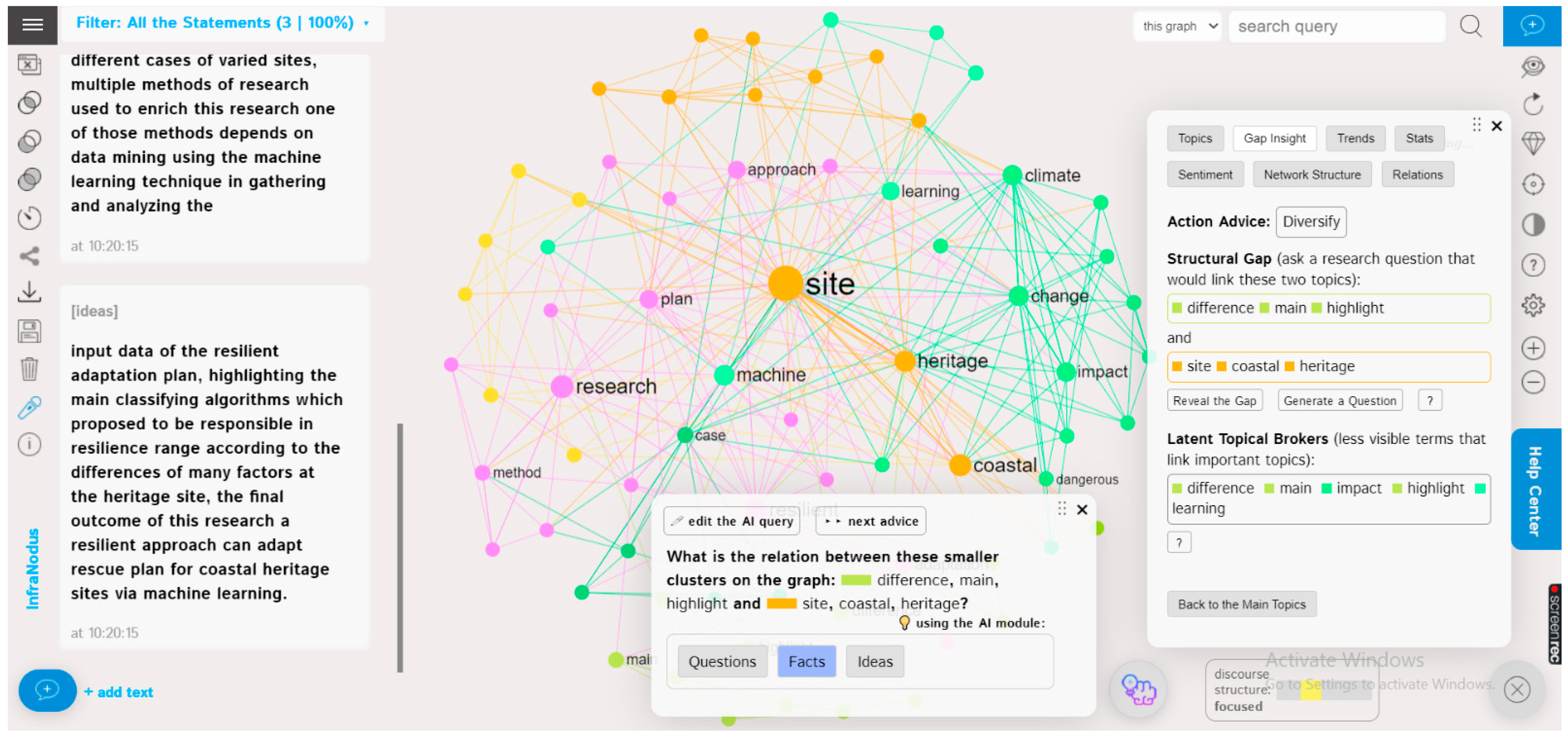
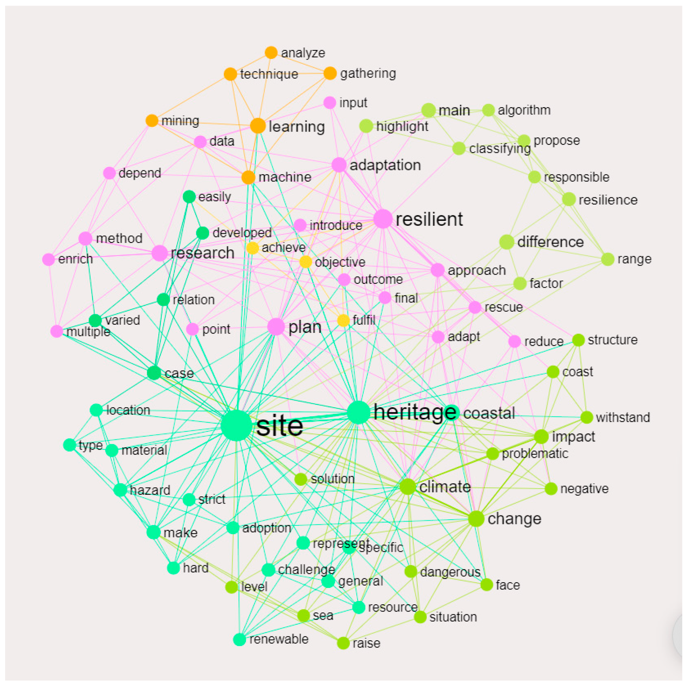
The research idea stated in the abstract and the research problem statement were used as the main seeds to generate the connections, facts, and ideas before being processed via two scientific search engines, namely Google Scholar and PubMed. This software works on a systematic similarity matrix and compares frequencies to reveal research gaps, as shown in
Figure 1.
The resulting cloud with different entries shows multiple clusters every time. When one is chosen, we can reveal all the connected text by selecting the Questions, Ideas, or Facts buttons, to be reclassified as output data files, i.e., CSVs. This technique also helps in specifying the algorithms of the adaptation actions, specifically related to the coastal heritage sites, as shown in
Figure 2.
It is advised that main node of the coastal heritage site connected with hazards and facing material deterioration, according to its type, be adapted strictly as it is a nonrenewable resource. All of those connections appear in one cluster, followed by the second nearest cluster, i.e., the climate change impacts highlighting the main defense procedures and solutions, and show that the major impact of climate change on coastal heritage sites is sea-level rise. The third cluster highlights the main methods to achieve the research objective of devising a resilience approach to adapting to the impacts of climate change on coastal heritage. The fourth cluster is related to machine learning, while the final cluster addresses the range of resilience and its related indicators.
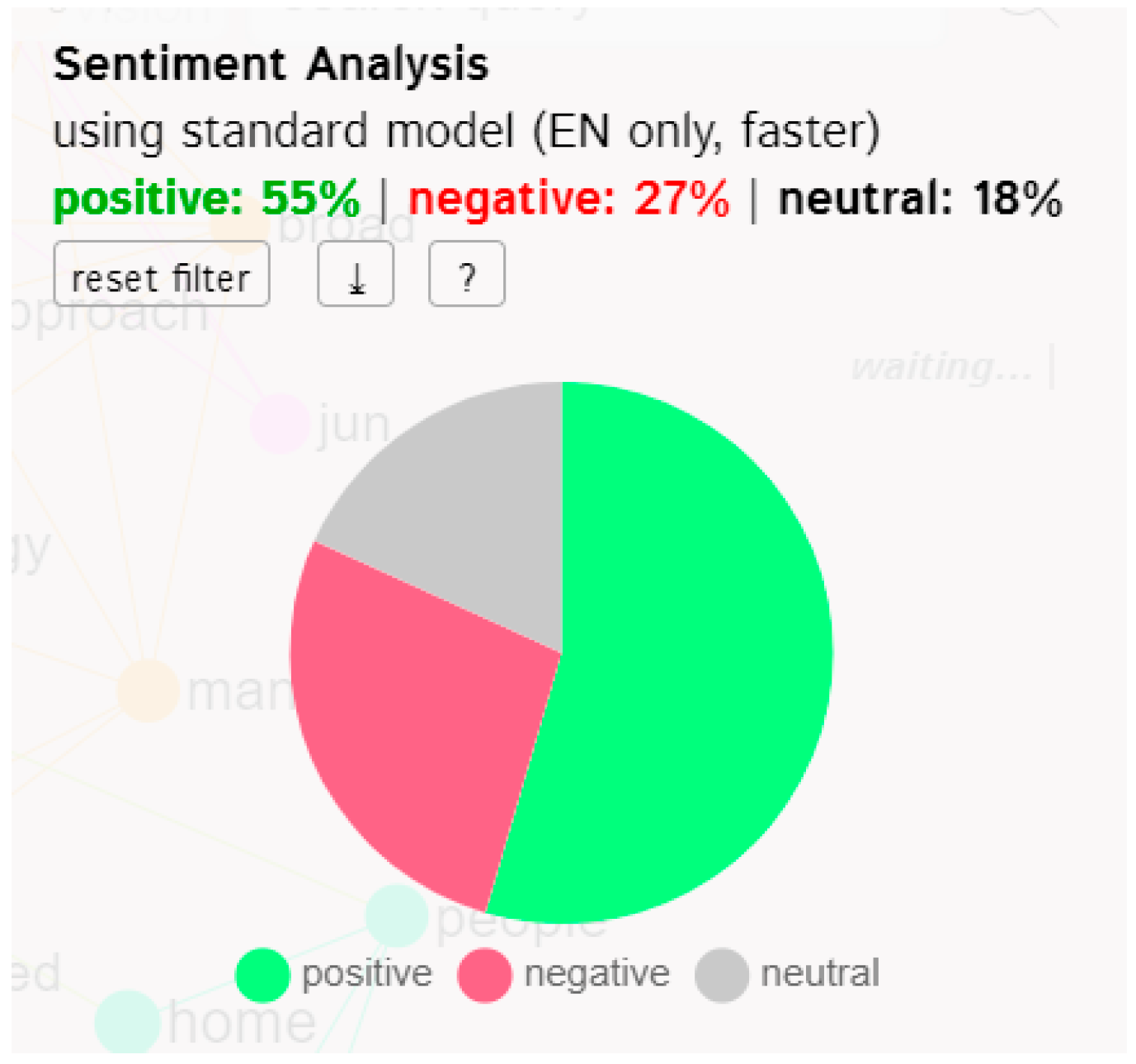
The data and clusters were analyzed through a series of various input data analyses to reach a semi-perfect combination of positive and negative text directions, taking the benefit of the positive, and avoiding or reversing the negative, as shown in
Figure 3,
Figure 4 and
Figure 5.
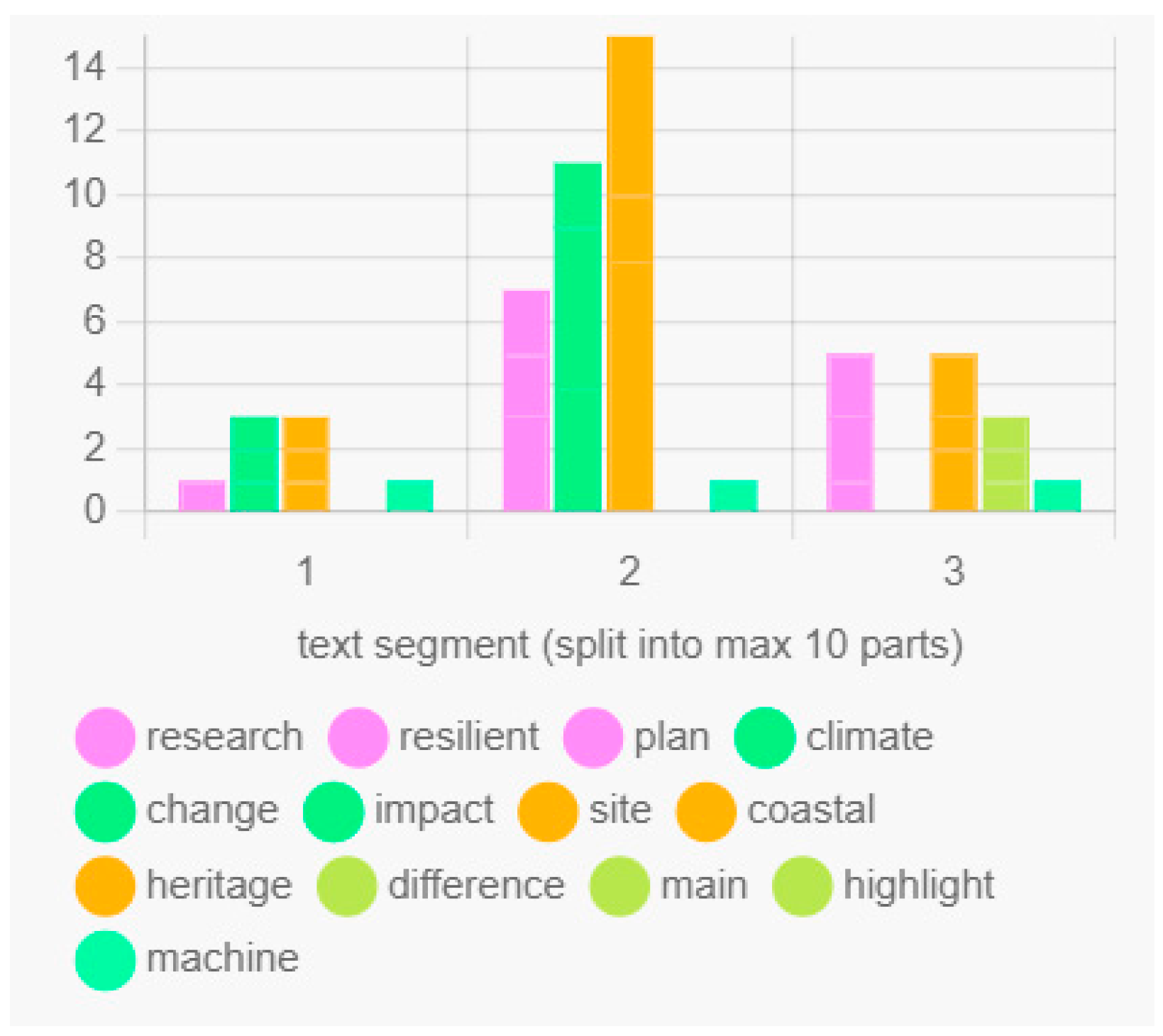
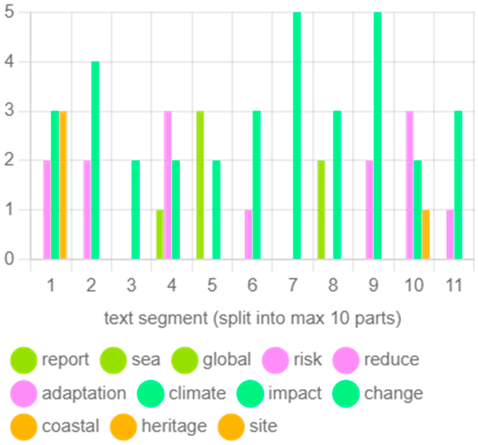
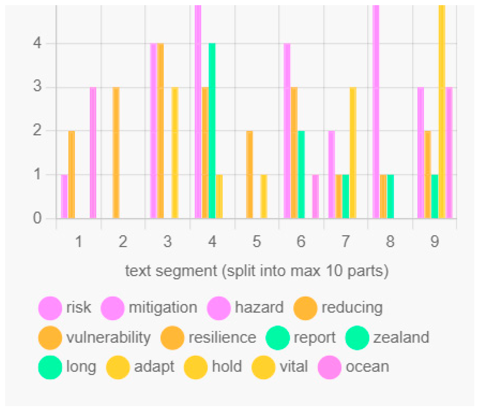
Another processing operation was performed using the evolution of topics that were implemented, by classifying the number of occurrences per text segmentation to show the connections between the clusters, splitting them into a maximum of ten parts, as shown in
Figure 6,
Figure 7 and
Figure 8.
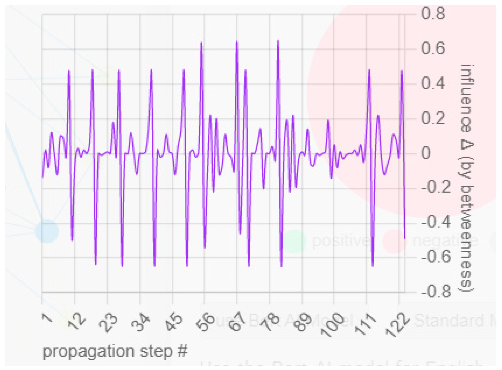
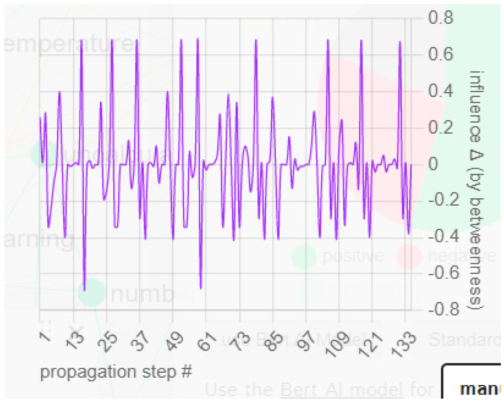
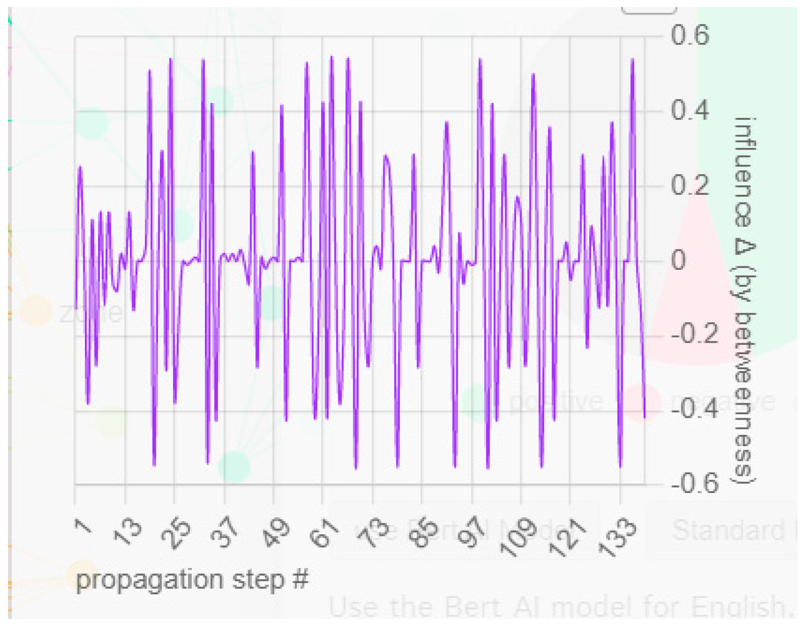
Narrative-influence propagation is usually performed after cumulative processing to regenerate ideas from the main topics and to show consistency and variability. This consistent presentation of the main clusters appears in the propagation dynamics processed via cyclical variability based on detrended fluctuation analysis of influence, as shown in
Figure 9,
Figure 10 and
Figure 11.
From the previous results and their related analysis, the resilience adaptation plan was conceptually formulated with respect to solutions, impacts, and priorities. The data were extracted as the final output of this step from the Infra Nodus software as a CSV file, as shown in
Table 3, to be used as an input for machine learning data mining using WEKA software.
4.2. Stage 2—Data Analysis Using WEKA
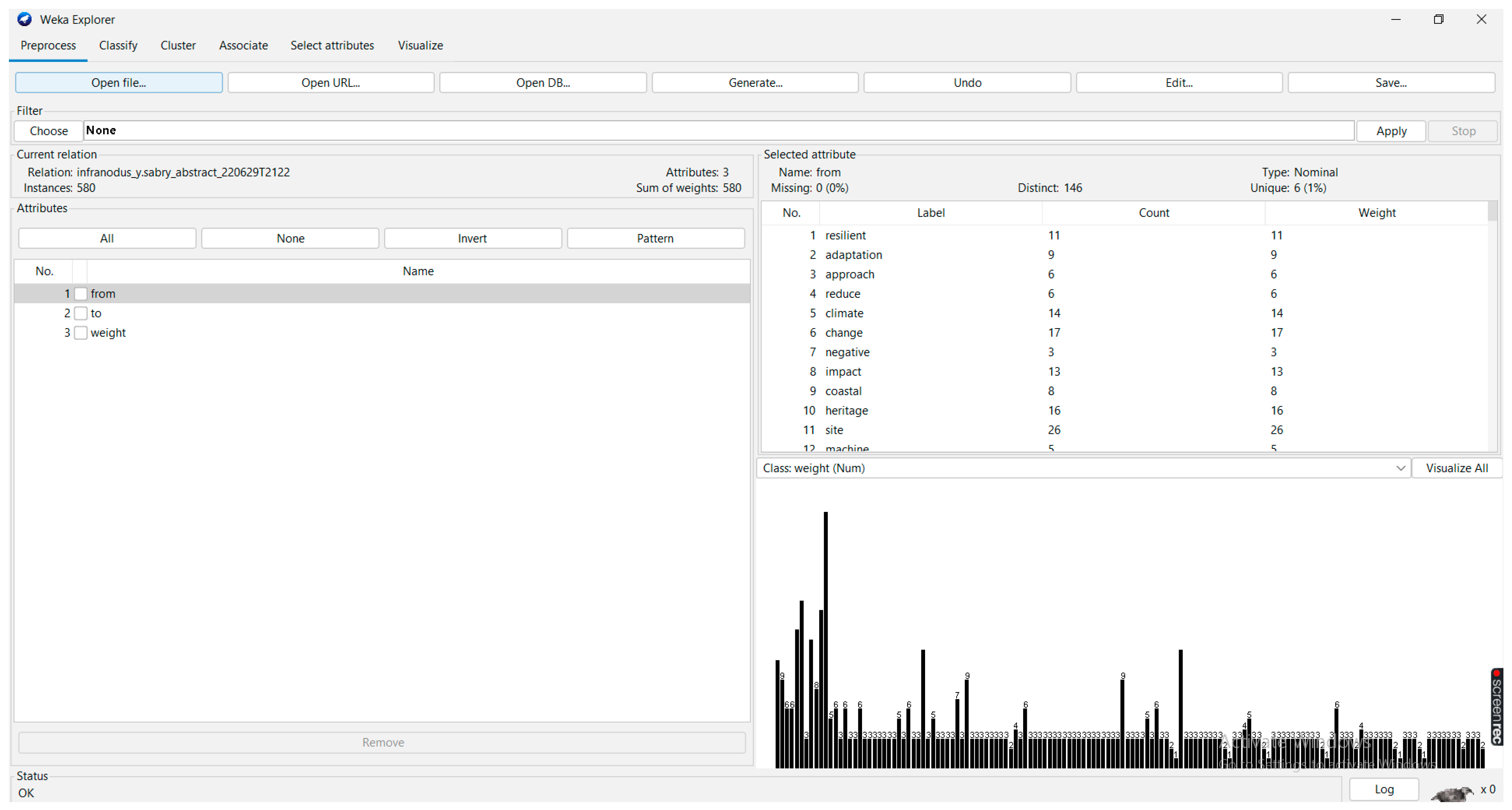
Waikato Environment for Knowledge Analysis (WEKA) was used as it is a free open-source package with a visual interface, established by the University of Waikato and the New Zealand government. It works with Java and can process a massive amount of data. WEKA is accessible on the internet and contains valuable content on information mining. Applications utilizing WEKA libraries can be run on any computer with web browsing capability; WEKA contains a predictive modeling tool related to patterns of algorithm use, together with graphical user interfaces for easy access to its functions. These features permit researchers to apply machine learning methods to their information at any computer stage. Machines are given pre-processing information, which is bolstered into an assortment of learning plans, analyzing classifiers, and their execution, in addition to their related algorithms. A vital asset for exploring that can be achieved through WEKA is its online documentation, which is produced from the source. The essential learning strategies in WEKA are “classifiers”, which can show a set or choice tree that models the information. WEKA has five applications under its software: the Explorer (which can be used to explore data and pre-process information), the Experimenter (which can be used to run experiments on the data), the Knowledge Flow, the Workbench, and a Simple CLI (command-line interface). The regression option in WEKA can prioritize the steps needed by taking the highest factors into consideration first; see
Figure 12 [
22].
The pre-processing shows the imported dataset using a bar graph, and the main features of the data processing tools can be summarized as follows:
Classification and regression algorithms;
Clustering algorithms;
Algorithms to find association rules;
Evaluators’ and researchers’ algorithms.
The basic purpose of using the WEKA software is to discover the common patterns of adapting coastal heritage sites in relation to climate change, in terms of solutions and priorities, to support designing a resilience approach for such cases in Egypt. This section highlights the main algorithms that can be used for the resilience range and the order of arrangement in the implementation. According to its predictive properties and each case, a machine learning method was used to obtain the maximum benefit from the huge amount of data in the Internet Cloud in relation to this subject.
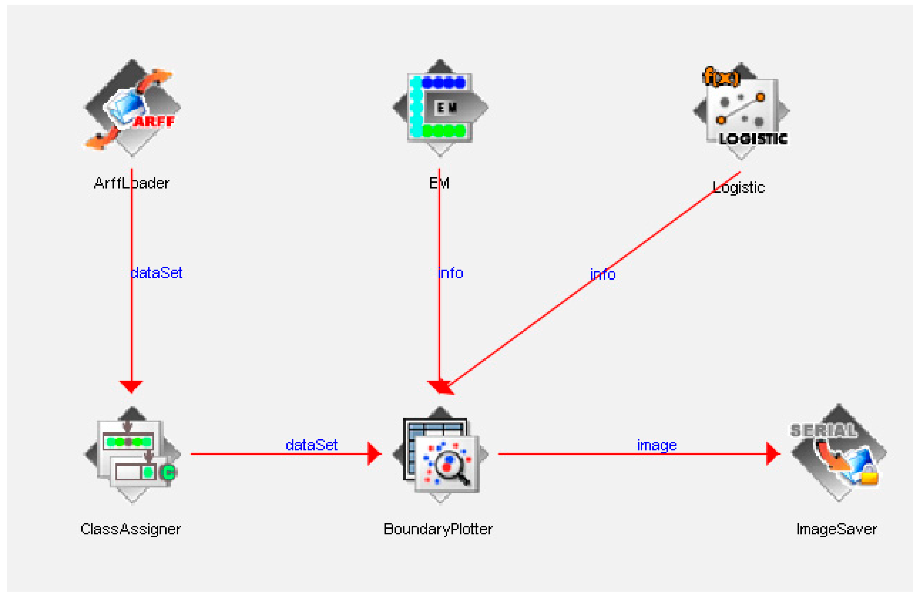
In this process, the data are passed through a pre-processing step. Then, association rules are determined to discover the main related components and their associated elements, which can be achieved either using visual tools or by programming attribute commands. To fulfill this operation, as shown in
Figure 13, a the following set of procedures can be used.
Data are transformed through Infra Nodus, and then, the CSV extraction files are re-entered into WEKA.
In data mining, the software applies, through its algorithms, a set of steps to find the pattern and range.
Pattern evaluation is used to review the final output qualitatively according to similar cases of analysis.
WEKA supports certain types of files, such as ARFF (Attribute-Relation File Format) and CSV (Comma-Separated Value).
CSVs were used in this research as they can be extracted from Excel spreadsheets directly so that the results can be visualized, as shown in
Figure 14. In addition, the visual qualifications of WEKA make machine learning easy for non-programmers.
In addition to the explorer, the workbench was used to combine the analysis of all the other applications under one perspective [
23].
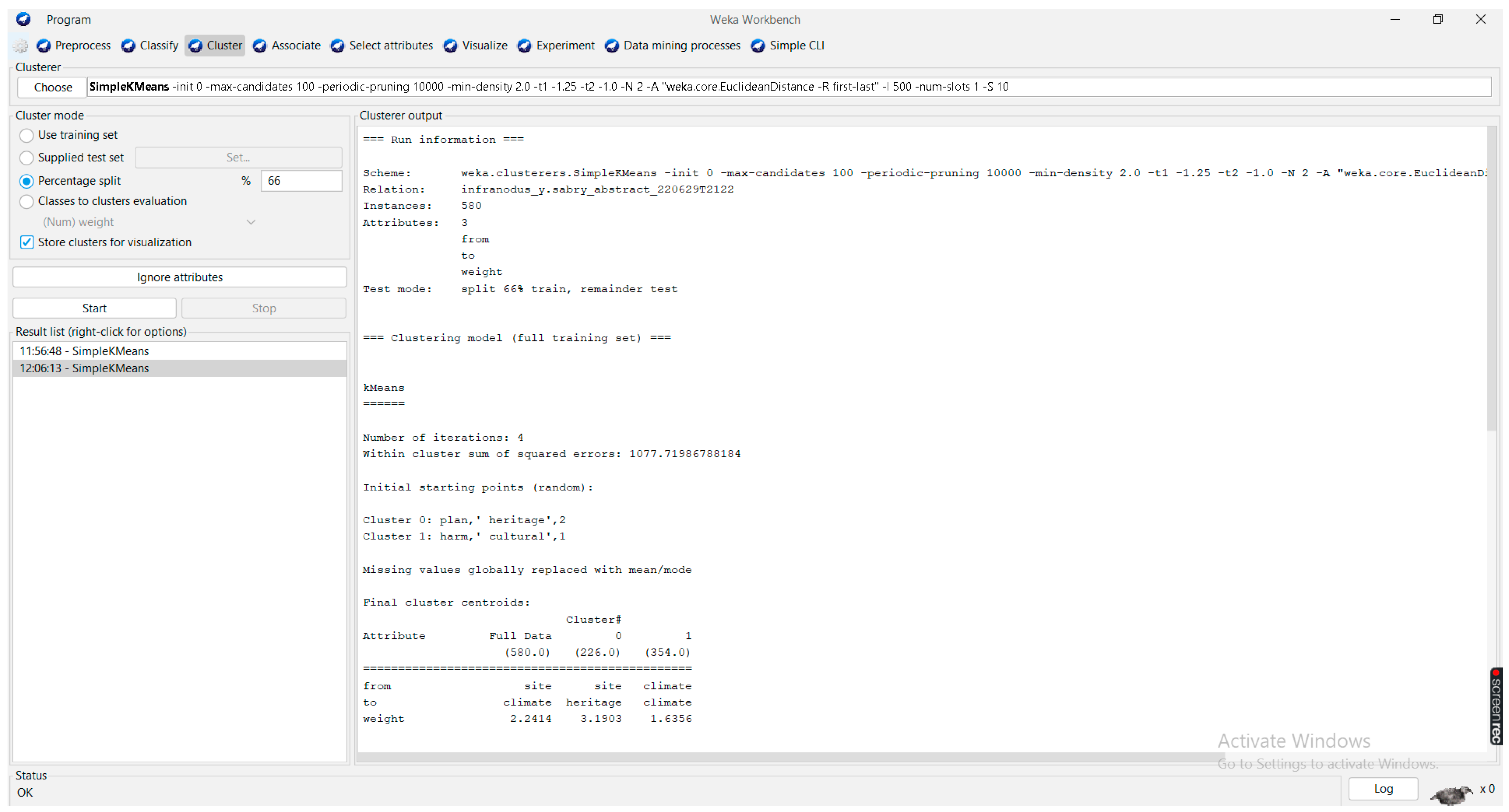
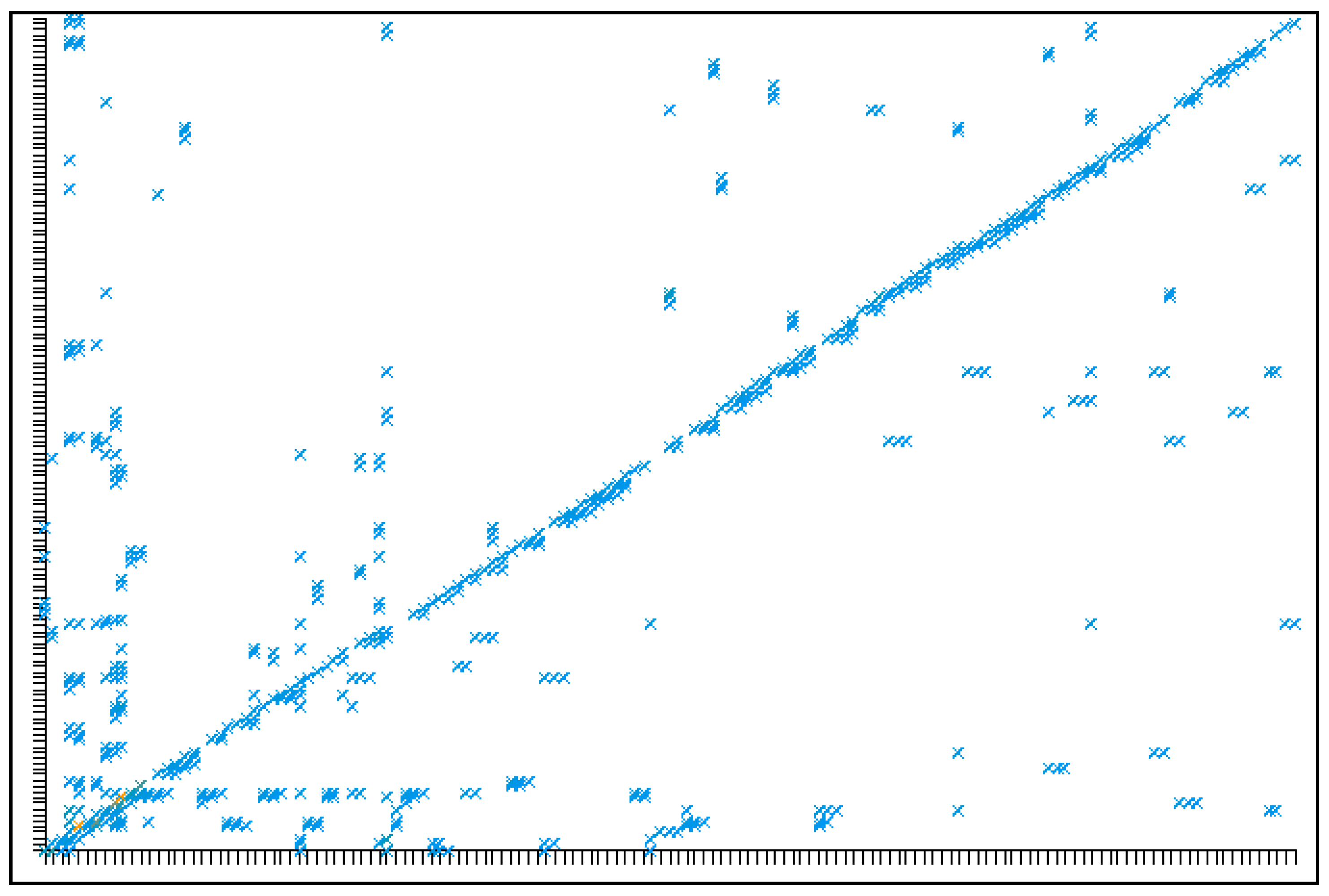
Cluster analysis is mostly used to estimate the accuracy of the resulting predictive model and to visualize erroneous predictions via regression algorithms, either through logistic regression or linear regression (they can be trained incrementally) (see
Figure 15).
From the application part, the resulting processed data from the literature review analyzed via machine learning, and prioritized and focused using the following output, are shown in
Table 4.
5. Validation of Alexandria as a Case Study
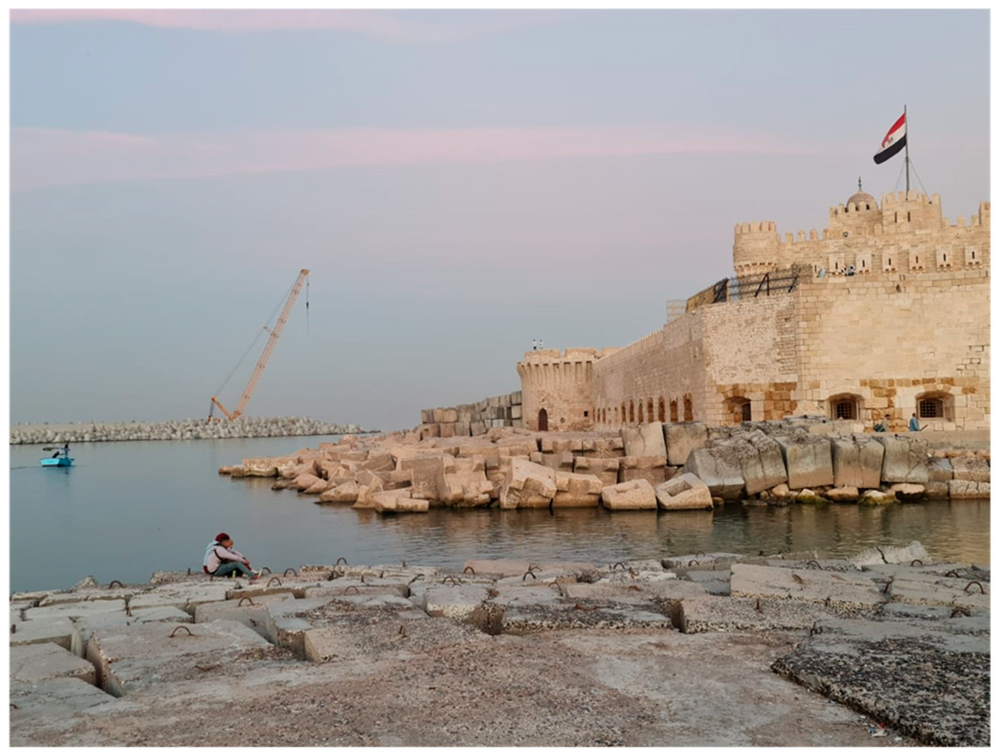
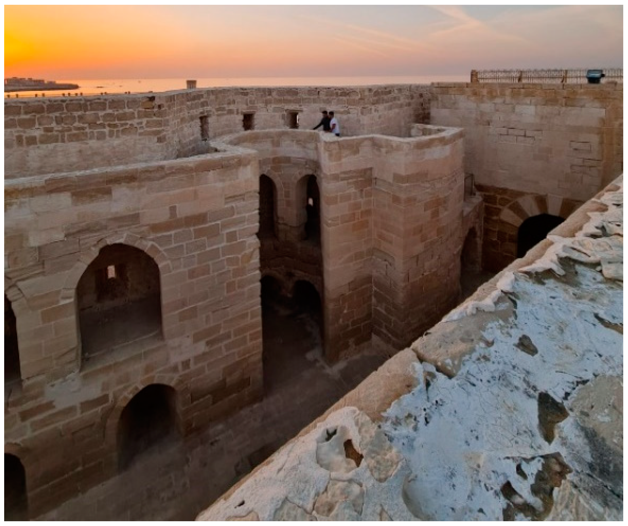
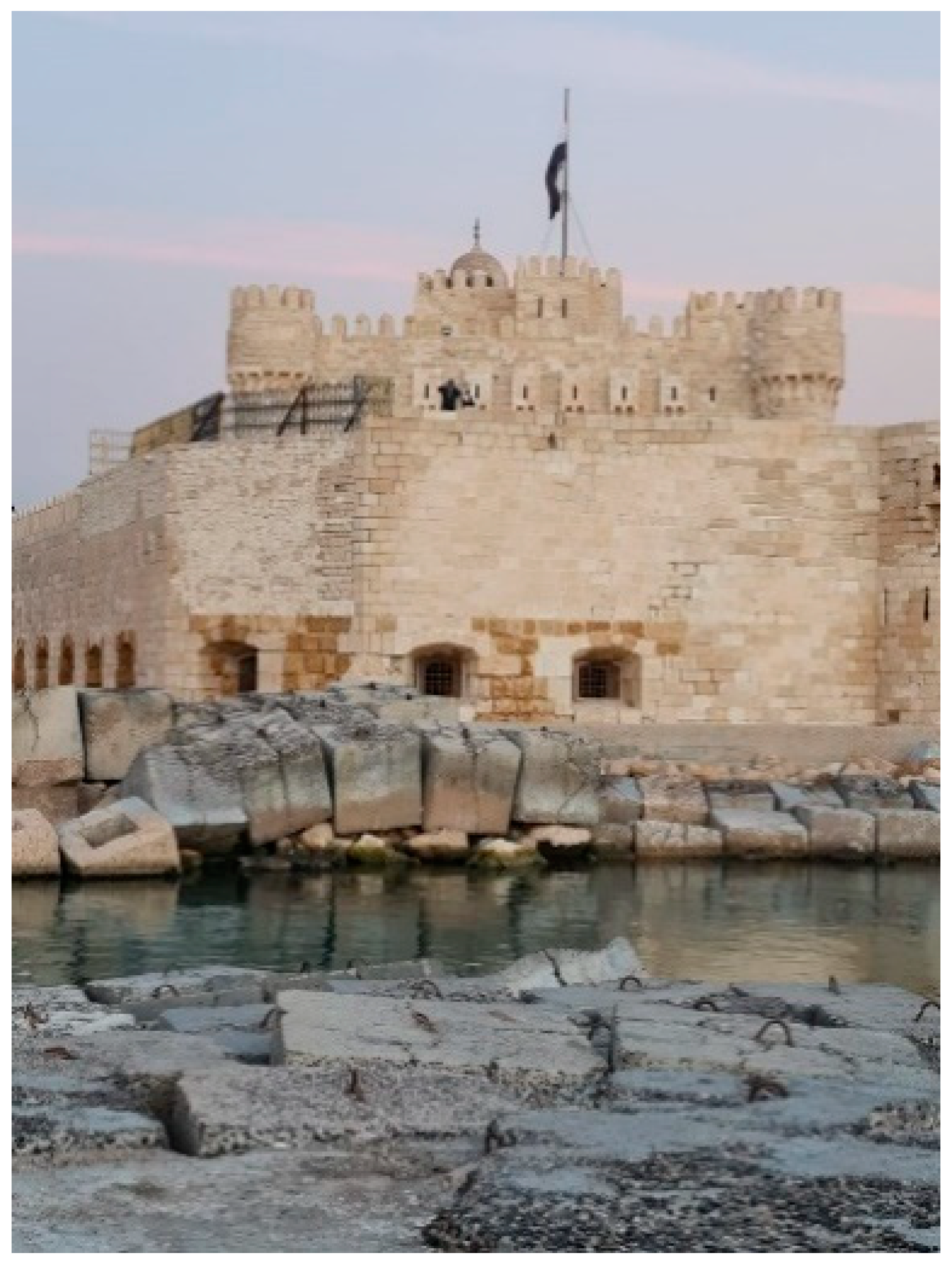
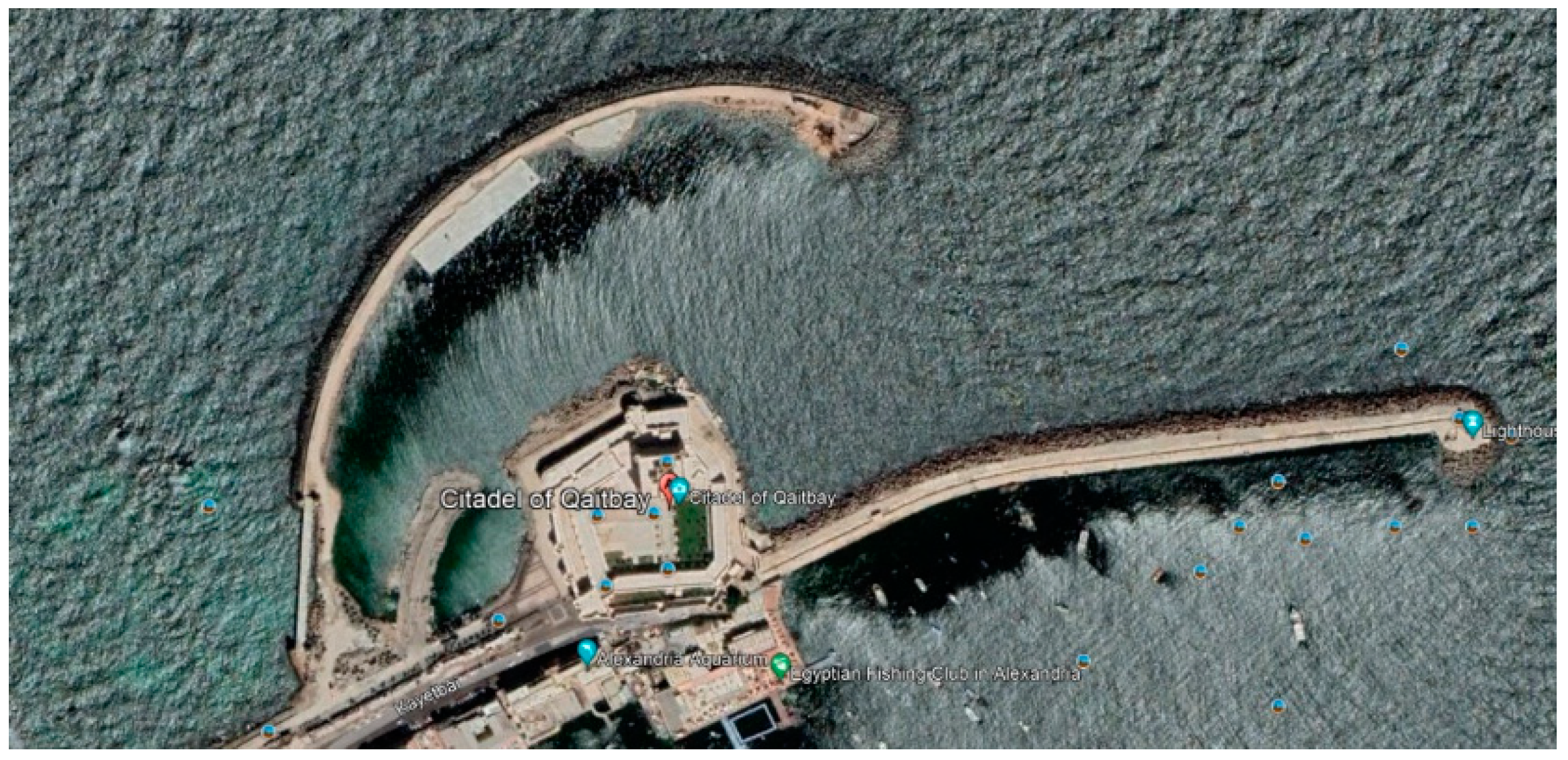
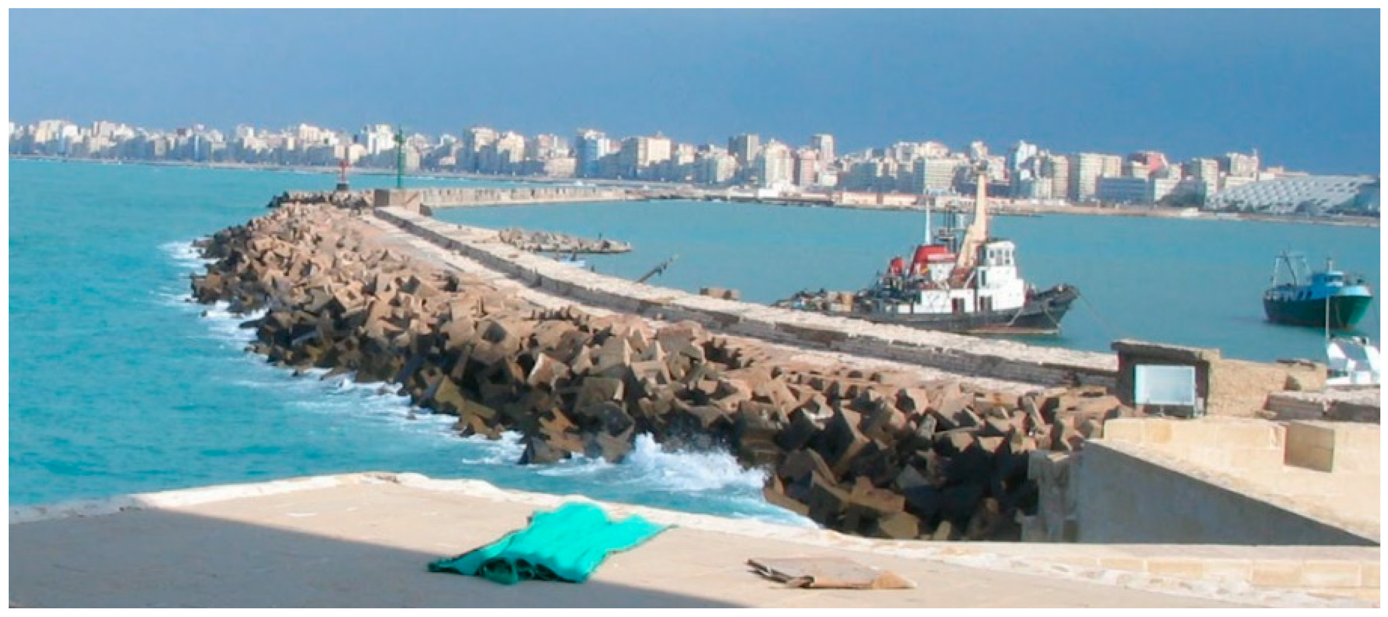
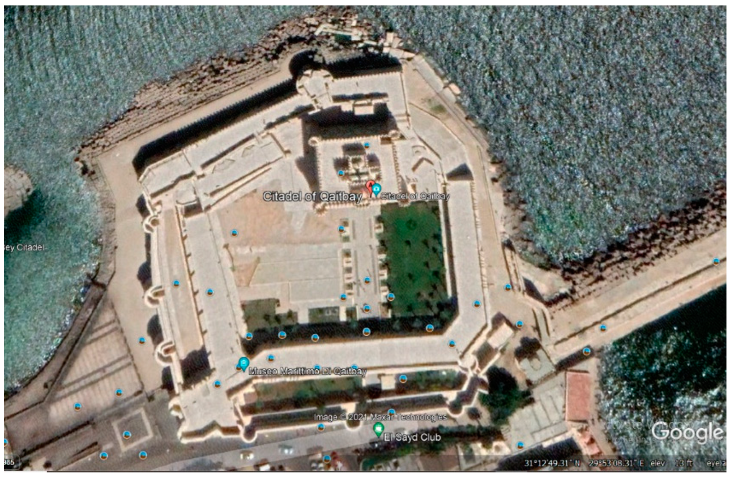
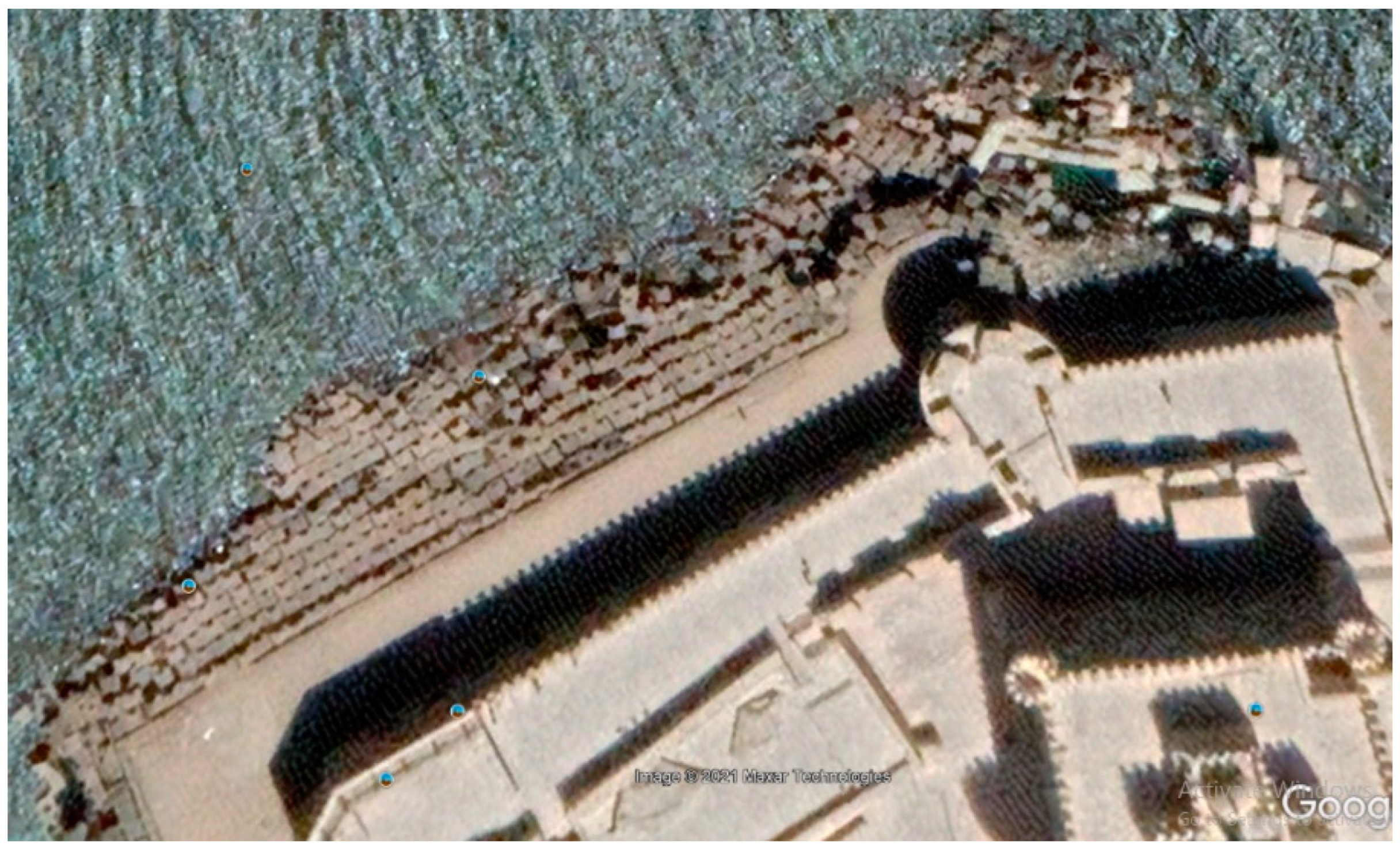
Alexandria, an Egyptian coastal city, is located on the Mediterranean Sea. It was founded by Alexander the Great when Egypt was under Greek rule. It has three important heritage sites—one of them on the ground, and the other two in the sea as islands. Those two sites are the Citadel of Qaitbay and the remains of the Light House in front of the Citadel, and the Royal Batlomic Neighborhood located underwater at the eastern port. A long debate has occurred since implementing a project to protect the Citadel by placing concrete masses around it to prevent waves from causing erosion and the site from vanishing in the long term. However, the debate was not only due to the visual impact of the masses, but also to their being dropped upon the remains of the Pharos Lighthouse. The debate involved discussions of how to preserve the past sustainably. The lighthouse vanished due to its location and natural circumstances, including waves and earthquakes. This is the current case for the Citadel. Despite the ugly concrete addition, the masses have kept the Citadel standing. In the 15th century, Mamluk Sultan Quitbaiy constructed his Citadel for military purposes upon one of the lighthouse’s remains. Another change involved some ancient city remains being covered with 2.5–5 m of seawater. The Citadel suffered from the settlement, and many cracks appeared in its flooring. The only protection method involved using concrete masses of about 20 tons. Because they were not sufficient, other concrete blocks were added in a wide circle to act as two defense lines.
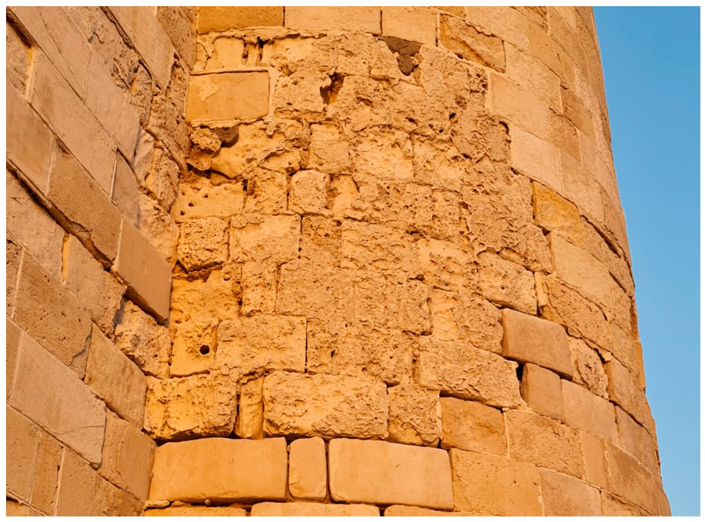
Egypt has four regional zones in terms of climate: the Mediterranean Sea sector, the Red Sea mountains, the desert, and the semi-desert. Global warming, causing other related phenomena, such as rising sea water levels, has badly affected the Egyptian heritage sites located in coastal areas, such as the Citadel of Quitbaiy in Alexandria. This valuable Citadel has been affected by two aspects of climate change. The first aspect is the problem itself, as climate change causes sea-level rise, which causes direct damage to the exterior material, e.g., surface flaking and missing limestone mortar; see
Figure 16,
Figure 17 and
Figure 18.
The solution itself reflects the other aspect of the effect. The authorities solved this problem by placing huge masses of concrete to prevent seawater from reaching the walls in addition to breaking the waves, which cause the deterioration of the materials. This solution was not only implemented in the zone directly attached to the historic site, but it was also implemented in a wider circle around the site to control the water level in addition to preventing any possible waves, providing double protection. However, it also created a double negative visual impact; see
Figure 19,
Figure 20,
Figure 21,
Figure 22 and
Figure 23.
The implemented solution has deteriorated the original visual image of the Citadel, as no-one can avoid seeing the concrete masses from any angle. The two layers of concrete have changed the architectural perception of the façades due to their volume, color, and height. Every side of the Citadel also has a different look and feel in relation to the concrete masses. Consequently, the solution has caused a negative impact [
25].
Despite the ugly appearance and the negative visual impact of the concrete blocks, thanks to this engineering solution Quitbaiy Citadel is still standing. Organized geometrical shape solutions may be more suitable, and underwater solutions could be better for reducing any ugly masses above the water level [
26].
Based on the focused model, which resulted from machine learning processing through the two stages of Infra Nodus and WEKA, the Delphi technique was applied to determine the details of the model. This technique can be defined as a forecasting process based on the results of multiple rounds of interviews sent to experts. After each round, a summary of the experts’ expectations from the previous round and their judgments were provided. Then, the process was stopped after the achievement of result stability.
The Delphi technique was used to detail the focused model and achieve agreement on the required actions, which were fulfilled in two rounds. In round 1, an interview was performed, investigating the details behind the actions needed. The results of round 1 were reflected in the model details. In round 2, the expert panel was asked to rearrange the priorities and categorize the actions of stakeholders. The goal of this round was to devise a reasonable national adaptation plan specifically for Alexandria [
27].
Ten experts were each interviewed twice and were assigned to a board, which ascribed criteria and weights to evaluate the national adaptation plan of the coastal area of Alexandria, specifically, the historic site of the Citadel of Qaitbay (see
Table 5).
6. The Final Output of the Resilience Plan: The National Adaptation Plan (NAP)
It is necessary to encourage national entities to create national adaptation plans tailored to every area according to their circumstances. As the impact of climate change is not resilient, resilience needs to be placed correctly in order for the plan to help. The impact of loss and damage to the mitigations embedded in the adaptation approach should be resilient to perceive the changing patterns of contextual and climate impact and the solutions themselves. The resilience approach lies between three levels: hard-to-predict, which considers non-linear behavior; rapidly spread, which considers things are not related to each other; and other categories comprising unpredictability, contagiousness, and modularity. Ensuring connectivity is an essential step in sharing knowledge between heritage sites that are either similar or non-similar.
In more extensive trials, some other approaches are taken to differentiate between high and low risks. The low risks have a simpler adaptation strategy, such as maintenance, building insulation, high capacity of the drainage system, water security, and storage, while the high risks deal with different levels of response, such as land management, coastline management, and change control; these are achieved by making adaptations more resilient to recovery through the concept of creating healing near to and far from the heritage building. Resilience is the capacity of any system to adapt to or heal from impacts, disturbances, or challenges. It concerns how to cope with change. This concept is used in many disciplines and in heritage management to understand and manage change. A system should highlight the boundaries and scales of the historic building as a case study to formulate resilience frameworks. The three terms related to designing adaptive systems are complexity, which refers to the presence of interconnected working elements; adaptability, which refers to constant change; and systems, which refer to the broad range of scales in which the elements interact (see
Table 5).
7. Conclusions
Adapting a heritage site in relation to climate change is not an easy task, as discussed in this research paper, and involves considering many factors, such as key impacts and actions. Heritage sites also have a pattern of deterioration according to the types of hazards. Therefore, the huge amount of data with respect to such sites can provide useful information, specifically under repetitive conditions. This literature review acted as a keystone and was used to formulate the main database for this research. Another part of the methodology was applied to process the resulting information from the previous studies via machine learning, to prioritize and evaluate the data. That part is considered a limitation of the research, as the Infra Nodus and WEKA software and analysis enabled us to set out the priorities, while regression could not be achieved completely and was intended to be focused on future research. A limitation was faced in using the advanced level of WEKA to achieve the tailored plan. Thus, the Delphi technique was used to rearrange and classify the final output, and it might be used in wider research with the computer science and communication research team.
Five steps were performed after the literature study. The application study started with the implementation outline of the adaptation plan; this was followed by prioritizing the adaptation strategies, shortening the list, and arranging it according to the priorities for the case study that was chosen in Alexandria, a heritage city facing a huge risk mitigated by the engineering solution of using concrete masses to reduce erosion. Although this solution is unattractive, it has saved the heritage site of the Citadel of Qaitbay. Experts who are experienced in Alexandrian heritage and the impact of climate change factors on the site, based on the resulting data from the machine learning, produced a national adaptation plan for the site; it is strongly recommended that this plan be applied to all the heritage sites, especially after conducting advanced research into the intended regression analysis developed by WEKA with the aforementioned team. Although it is impossible to control the climate, heritage sites can adapt to its impacts, which can be reduced.


