Object-Based Geomorphological Mapping: Application on an Alpine Deep-Seated Gravitational Slope Deformation Contest (Germanasca Valley, Western Alps—Italy)
Abstract
1. Introduction
2. Materials and Methods
2.1. Object-Based Method
- -
- Opportunity to integrate the geomorphological map with a specially dedicated database containing some landform details, not represented by “traditional” symbols (dimensions, processes, age);
- -
- Hierarchical taxonomy whose levels are organized in terms of “topological nested entities”, represented by polygons. Decreasing the scale of representation, a polygon can be mapped as lines, point symbols, backgrounds and annotations;
- -
- Use of GIS technology that allows the production of cartographic representations that are continuously updatable, to obtain subdivisions and morphometric parameters, carry out numerical analysis and extract several thematic maps to be used, from time to time, in specific fields of application.
- -
- Construction of a geomorphological “traditional” map and a geological map to the same scale;
- -
- Construction of a hierarchic table of attributes in a GIS environment;
- -
- Drawing of landforms that, on the base of the representation scale, correspond to point, polyline or polygon.
2.2. Detailed Material
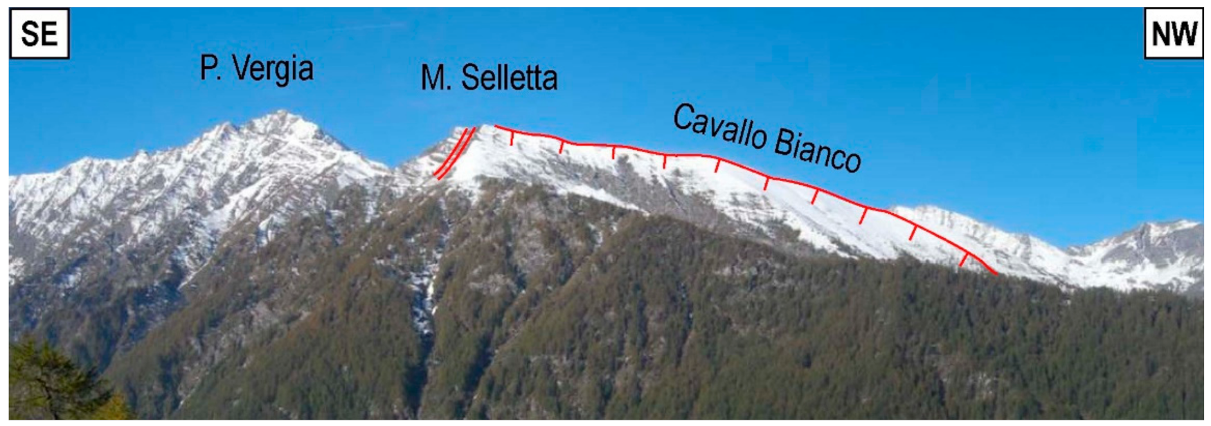
2.3. Gravitational Geomorphological Features
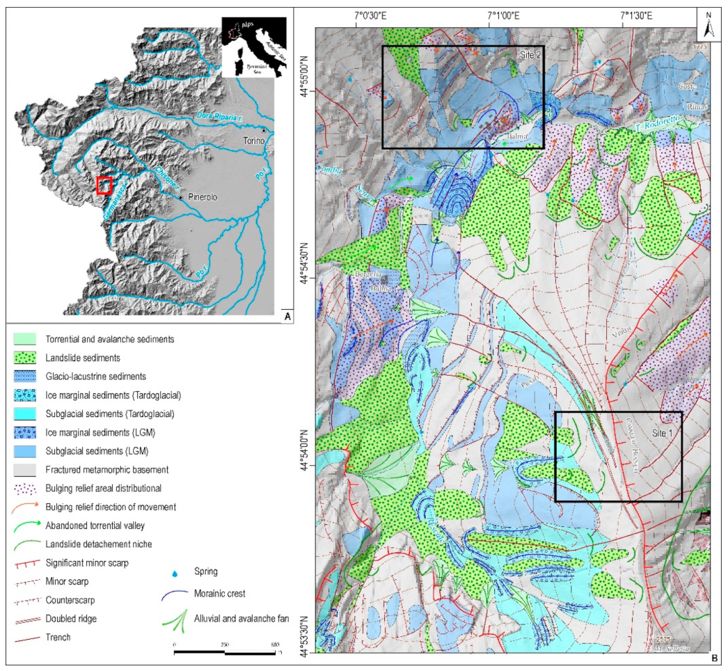
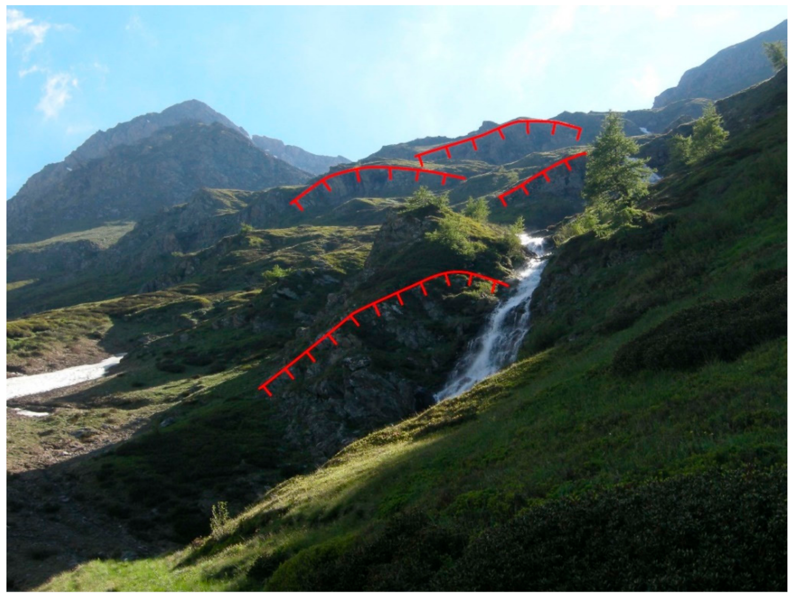
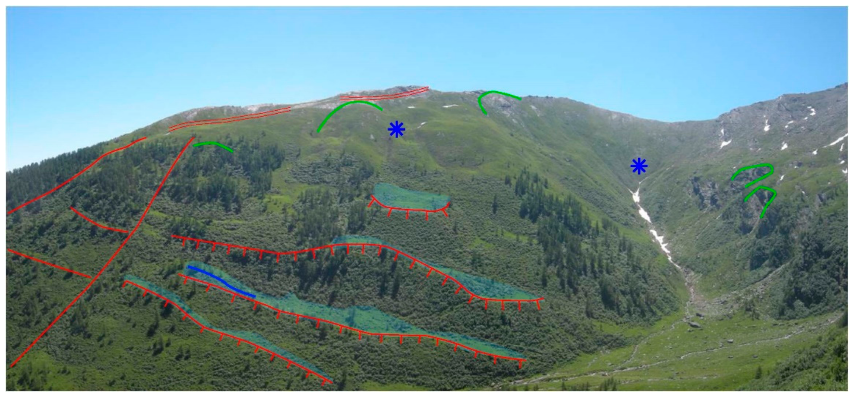
2.4. Geomorphological Features of the Two Examples
3. Results and Discussion
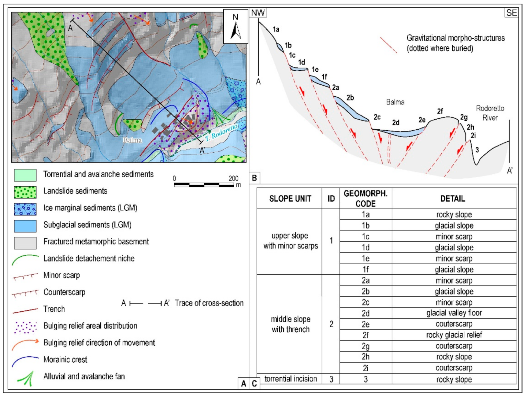
- A linear symbol cannot represent the entire sector affected by a morpho-structure nor specify its areal size;
- Very close-together morpho-structures usually cannot be reported, if not using a proper detailed mapping scale;
- The relationships between the different geomorphological elements cannot always be represented, except when linear symbols intersect each other.
4. Conclusions
Author Contributions
Funding
Institutional Review Board Statement
Informed Consent Statement
Data Availability Statement
Conflicts of Interest
References
- Smith, M.J.; Paron, P.; Griffiths, J.S. Geomorphological mapping, methods and applications. In Developments in Earth Surface Processes; Elsevier: Oxford, UK, 2011; p. 15. [Google Scholar]
- Seijmonsbergen, A.C. The Modern Geomorphological Map. In Methods in Geomorphology; Switzer, A., Kennedy, D.M., Eds.; Elsevier: Amsterdam, The Netherlands, 2013; pp. 35–52. [Google Scholar]
- Piras, M.; Taddia, G.; Forno, M.G.; Gattiglio, M.; Aicardi, I.; Dabove, P.; Lo Russo, S. The use of Unmanned Aerial Vehicle (UAV) for detailed geological mapping in mountain area: Test and results. Geomat. Nat. Hazards Risk 2017, 8, 137–149. [Google Scholar] [CrossRef]
- Guida, D.; Palmieri, V.; Paron, P.; Siervo, V. The geomorphological informative mapping system (GIMS) of Salerno University: An Overview. Application to a Polygenetic Mediterranean Landscape (Cilento and Vallo di Diano European Geopark). In Proceedings of the IAG/AIG International Workshop on “Objective Geomorphological Representation Models: Breaking through a New Geomorphological Mapping Frontiere, Salerno, Italy, 15–19 October 2012; pp. 73–77. [Google Scholar]
- Dramis, F.; Guida, D.; Cestari, A. Nature and aims of geomorphological mapping. In Geomorphological Mapping: Methods and Applications; Smith, M.J., Paron, P., Griffith, J.S., Eds.; Elsevier: Amsterdam, The Netherlands, 2011; Volume 15, pp. 39–73. [Google Scholar]
- Dramis, F.; Guida, D.; Cestari, A.; Siervo, V.; Palmieri, V. Dalla cartografia geomorfologica al sistema cartografico geomorfologico: Metodologie, procedure e applicazioni. Geol. Tecnia Ambient. 2011, 3, 10–25. [Google Scholar]
- Taddia, G.; Gnavi, L.; Piras, M.; Forno, M.G.; Lingua, A.; Lo Russo, S. Landslide susceptibility zoning using GIS tools: An application in the Germanasca Valley (NW Italy). In Engineering Geology for Society and Territory Landslide Processes, Proceedings of the IAEG XII Congress 2014, Torino, Italy, 15–19 September 2015; Springer: Cham, Switzerland, 2015; Volume 2, pp. 177–181. [Google Scholar] [CrossRef]
- Forno, M.G.; Lingua, A.; Lo Russo, S.; Taddia, G. Improving digital tools for Quaternary field survey: A case study of the Rodoretto Valley (NW Italy). Environ. Earth Sci. 2011, 64, 1487–1495. [Google Scholar] [CrossRef]
- Forno, M.G.; Lingua, A.; Lo Russo, S.; Taddia, G. Morphological features of Rodoretto Valley deep-seated gravitational slope deformations. Am. J. Environ. Sci. 2012, 8, 648–660. [Google Scholar] [CrossRef][Green Version]
- Forno, M.G.; Lingua, A.; Lo Russo, S.; Taddia, G.; Piras, M. GSTOP: A new tool for 3D Geomorphological survey and mapping. Eur. J. Remote Sens. 2013, 46, 234–249. [Google Scholar] [CrossRef]
- Forno, M.G.; Gattiglio, M.; Gianotti, F.; Rossato, S.; Taddia, G. Deep-seated gravitational slope deformation effects on Quaternary deposits in the western alps (NW Italy). Alp. Mediterr. Quat. 2020, 33, 43–60. [Google Scholar] [CrossRef]
- Drăguţ, L.; Blaschkeb, T. Automated classification of landform elements using object-based image analysis. Geomorphology 2006, 81, 330–344. [Google Scholar] [CrossRef]
- Dikau, R.; Brabb, E.E.; Mark, R.M. Landform classification of New Mexico by computer. US Department of the Interior, US Geological Survey. Open-File Rep. 1991, 91, 634. [Google Scholar]
- Hughes, J.H. Object-Oriented Databases; Prentice Hall: Englewood Cliffs, NJ, USA, 1991; p. 602. [Google Scholar]
- De Pippo, T.; Guida, D.; Lanzara, V.; Siervo, V.; Valente, A. Criteri, Metodi e Procedure Innovative per la Redazione di Cartografia Geomorfologica Gerarchica Multiscalare: Proposte Operative in Ambiente GIS. In Proceedings of the Convegno Nazionale AIGEO “Ambiente Geomorfologico e Attività dell’Uomo: Risorse, Rischi, Impatti”, Torino, Italy, 28–30 March 2007; pp. 230–234. (In Italian). [Google Scholar]
- Anders, N.S.; Seijmonsbergen, A.C.; Bouten, W. Multi-scale and object-oriented image analysis of high-res LiDAR data for geomorphological mapping in Alpine Mountains. In Proceedings of the Geomorphometry, Zurich, Switzerland, 31 August–2 September 2009; pp. 61–63. [Google Scholar]
- Forno, M.G.; Gattiglio, M.; Taddia, G.; Ghignone, S. Deep-seated gravitational slope deformation involving glacial evidence in the Rodoretto Valley (NW Alps). J. Maps 2021, 17, 846–858. [Google Scholar] [CrossRef]
- Forno, M.G.; Massazza, G. Movimenti gravitativi diffusi e ripetuti nel versante sinistro della Val Cenischia (Alpi Graie) e loro relazione con il sistema di fratture Cenischia—Nizza. Geogr. Fis. Dinam. Quatern. 1987, 10, 277–306. [Google Scholar]
- Forno, M.G.; Comina, C.; Gattiglio, M.; Gianotti, F.; Lo Russo, S.; Sambuelli, L.; Raiteri, L.; Taddia, G. Preservation of Quaternary sediments in DSGSD environment: The Mont Fallére case study (Aosta valley, NW Italy). Alp. Mediterr. Quat. 2016, 29, 181–191. [Google Scholar]
- Bunn, M.; Leshchinsky, B.; Olsen, M.; Booth, A. A Simplified, Object-Based Framework for Efficient Landslide Inventorying Using LIDAR Digital Elevation Model Derivatives. Remote Sens. 2019, 11, 303. [Google Scholar] [CrossRef]
- Zhang, J.; Wu, C.; Wang, L. A Conceptual Framework for the Automated Generalization of Geological Maps Based on Multiple Agents and Workflow. IEEE Access 2016, 4, 6374–6385. [Google Scholar] [CrossRef]
- Sayidov, A.; Aliakbarian, M.; Weibel, R. Geological Map Generalization Driven by Size Constraints. ISPRS Int. J. Geo-Inf. 2020, 9, 284. [Google Scholar] [CrossRef]



Publisher’s Note: MDPI stays neutral with regard to jurisdictional claims in published maps and institutional affiliations. |
© 2022 by the authors. Licensee MDPI, Basel, Switzerland. This article is an open access article distributed under the terms and conditions of the Creative Commons Attribution (CC BY) license (https://creativecommons.org/licenses/by/4.0/).
Share and Cite
Forno, M.G.; Fubelli, G.; Gattiglio, M.; Taddia, G.; Ghignone, S. Object-Based Geomorphological Mapping: Application on an Alpine Deep-Seated Gravitational Slope Deformation Contest (Germanasca Valley, Western Alps—Italy). Appl. Sci. 2022, 12, 778. https://doi.org/10.3390/app12020778
Forno MG, Fubelli G, Gattiglio M, Taddia G, Ghignone S. Object-Based Geomorphological Mapping: Application on an Alpine Deep-Seated Gravitational Slope Deformation Contest (Germanasca Valley, Western Alps—Italy). Applied Sciences. 2022; 12(2):778. https://doi.org/10.3390/app12020778
Chicago/Turabian StyleForno, Maria Gabriella, Giandomenico Fubelli, Marco Gattiglio, Glenda Taddia, and Stefano Ghignone. 2022. "Object-Based Geomorphological Mapping: Application on an Alpine Deep-Seated Gravitational Slope Deformation Contest (Germanasca Valley, Western Alps—Italy)" Applied Sciences 12, no. 2: 778. https://doi.org/10.3390/app12020778
APA StyleForno, M. G., Fubelli, G., Gattiglio, M., Taddia, G., & Ghignone, S. (2022). Object-Based Geomorphological Mapping: Application on an Alpine Deep-Seated Gravitational Slope Deformation Contest (Germanasca Valley, Western Alps—Italy). Applied Sciences, 12(2), 778. https://doi.org/10.3390/app12020778


