Article

Geoarchaeological Investigation of Abydos Area Using Land Magnetic and GPR Techniques, El-Balyana, Sohag, Egypt

by
Abdelbaset M. Abudeif
1,*,
Gamal Z. Abdel Aal
2,
Marwa M. Masoud
1 and
Mohammed A. Mohammed
1
1
Geology Department, Faculty of Science, Sohag University, Sohag 82511, Egypt
2
Geology Department, Faculty of Science, Assiut University, Assiut 71515, Egypt
*
Author to whom correspondence should be addressed.
Appl. Sci. 2022, 12(19), 9640; https://doi.org/10.3390/app12199640
Submission received: 29 August 2022 / Revised: 16 September 2022 / Accepted: 19 September 2022 / Published: 26 September 2022
(This article belongs to the Section Earth Sciences)

Abstract

:
Abydos Temple is one of Egypt’s most significant sites which has a long history that dates back to the ancient monarchy and continued until the coming of Islam and also served as one of Egypt’s most significant ancient royal and high-ranking official burial sites. The main objective of this work was discovering more archaeological features buried underground such as ancient walls, monuments, and tombs. This objective was achieved using two near surface sophisticated geophysical techniques, namely ground magnetic survey and ground penetrating radar (GPR). This site was surveyed firstly using ground magnetic survey as reconnaissance stage and the locations which contain potential anomalies were resurveyed using GPR technique for determination the depth and the geometry of this potential targets. This site was divided into four regular grids and GPR model SIR-4000 equipment with 200 MHz central frequency antenna was used in this survey. The output of the magnetic survey is a total magnetic anomaly map which was filtered using High pass (HP) and first vertical derivative (VFD) techniques to extract the residual component of the shallow objects which may be archaeological targets. The results of the magnetic methods showed a group of anomalies which appeared on the residual map and were attributed to archaeological features by comparing them with the current excavated objects in and around the site. Their geometrical shapes and depths were estimated using source parameter imaging (SPI) and analytical signal (AS) techniques in Geosoft Oasis Montag Software. The estimated depth of these objects is between 1–3 m. Several hyperbolic shapes appeared in the radargram sections, indicating the possibility of probable buried archaeological objects. These potential objects can be found at depths of 2 to 4 m below the ground surface. The presence of eight probable targets associated with archaeological features at depths between 1–4 m is therefore the most likely outcome from both magnetic and GPR approaches. Therefore, this site contains potential archaeological targets which need confirmation by excavation. These results will influence domestic and foreign tourism in Egypt, leading to an increase in visitors and a rise in Economy.

1. Introduction

Archaeogeophysics and archaeological prospecting are focused on the description of disparities between subsurface ancient relics and their surrounding rocks. Various geophysical investigations on the surface, such as geomagnetism, electric resistivity, electromagnetic method, and ground penetrating radar (GPR), can be used to properly locate the depth and dimension of subsurface remains, allowing for precise excavations.
Ground magnetic survey relies on the differences in the magnetic characteristics of an object of interest and its surroundings. For archaeological study, the two most crucial magnetic factors are magnetization and magnetic susceptibility. Most archaeological materials contain magnetic particles, which have magnetic properties and allow them to create magnetic anomalies that can be utilized in a number of different ways. The produced total magnetic intensity (TMI) map may track the changes in the strength of the Earth’s magnetic field because of the different compositions of the archaeological features and the surrounding soil. Depending on how susceptible rock is to magnetic anomalies, they can either be positive (a stronger field than normal) or negative (a weaker field) [1].
GPR is a geophysical technology used to properly map the geometrical dimensions of near-surface objects, archaeological artifacts, and produce 3D imaging of subsurface materials. GPR technique is employed in geological and environmental studies, engineering and construction purposes, glaciological studies, forensic science, and archaeological explorations. Since it is a very affordable, safe, and non-destructive tool for imaging shallow subsurface objects, this technology is ideal for investigating the geometry of archaeological features [2]. GPR is a high-resolution geophysical device that utilizes high-frequency electromagnetic signals from a transmitting antenna to propagate through the earth and be reflected back to the surface, where they are recorded by another receiving antenna. The time it takes for the reflections to return to the surface is then measured [3,4,5]. This technique is based on the vertical and horizontal changes in dielectric constant and conductivity of the underlying materials. Due to the varied reflection coefficients of the interfaces, this feature causes changes in the velocity of radar waves through the material.
Many authors used both GPR and magnetic methods or one of them, to investigate archaeological structures in various Egyptian ancient sites for archeological investigation [6,7,8,9,10,11,12,13,14,15,16,17,18,19,20,21,22,23,24,25,26,27,28,29,30,31,32,33]. On the other hand, this technique was employed worldwide in numerous countries for the same purposes [34,35,36,37,38,39,40,41,42,43,44,45,46,47,48,49,50,51,52,53].
The main objective of this paper employing both ground magnetic and GPR surveys for investigation of Abydos site in order to detect and determine the depth and the geometry of any unearthed archaeological features. The findings of this study could be utilized as a guide by authorities during the excavation process, saving money and time by providing accurate positions, depths, and geometries of undiscovered/unearthed archaeological remains.

2. Location and History of Study Area

The Abydos site is one of Upper Egypt’s oldest archaeological sites. This site dates back 4000 years. It’s about 13 km west of the Nile, alongside the town of El-Balyana, which is part of the Sohag governorate (Figure 1a). The ancient Egyptian Abedju site, where the early pharaohs were interred, was one of the most prominent burial grounds for monarchs and high court functionaries in ancient Egypt (original name of the present Abydos). It also represents the site of a number of ancient temples, including the royal necropolis. The city of Abydos became Egypt’s most venerated district since it was associated with Osiris’ religion and the desired burial locations for the earliest and oldest monarchs, such as Seti I and Ramses II [54,55].
The Abydos Temple was constructed in two parts: one on Holocene Nile sediment and the other on older Nile sediments created by the Nile’s terrace. The Osirion was built 15 m below ground level under the Temple of Seti I, where the Pharaonic funeral rites took place. Since the dead bodies were cleansed during these ceremonies, water was brought to the Osirion site either by reaching the water table level or by excavating extensive canals that connect the site to the Nile River. This water’s source will be examined in more detail in a future work by the same authors.
The citizens of El-Amra first inhabited the area surrounding the Temple of Abydos, and then Najada built the settlement that is now known as Abedju. In Pharaonic times, the Temple of Abydos was the most famous destination for the burial of kings and high court dignitaries. As a result, Khontamenti, the Death-God, was worshipped in the town and its necropolis. With the religion of Osiris, who was the God of life in the underworld and resurrection and had emerged in the Delta region, the significance of the Abydos increased, gained traction in Abydos, and eventually Osiris was offered a temple and considered as Khontamenti’s equal [55]. The Tomb of Osiris is thought to be located on the Umm El-Qaab hill. Later, from the sixth dynasty onwards, the dead from all over Egypt were buried in the temple of Abydos. In addition, kings, affluent people, and heavenly Egyptians were buried near the Tomb of Osiris. Since every decedent is an Osiris in Egyptian theology, being close to the god of the dead improves the likelihood that the soul will be raised to life and granted eternal life. As a result, the Abydos Temple has become one of the most important cultural places for festivals, particularly those commemorating God’s feast day mysteries [55].
During the reigns of the two kings, Seti I and Ramses II, Abydos achieved its pinnacle of splendor for political and religious reasons, and it became one of Egypt’s greatest masterpieces. Mariette, for example, excavated the Temple of Seti I at the cost of the Khedive, Said Pasha, in 1859, and carried out extensive excavations at the Abydos site during the previous century. In 1896, M. de Morgan unearthed a significant Neolithic site east of Abydos. Miss Margaret Murray later discovered the Osirion’s entrance route in 1903. Many key sites have yet to be uncovered, and the Abydos desert still conceals many unknown secrets [54,56,57].
The study area is in Upper Egypt’s center region. On the western bank of the Nile Valley, it is an important heritage site. The study region spans the latitudes of 26°10′ N and 26°15′ N, as well as the longitudes of 31°53′ E and 31°57′ E. It is around 13 km west of the city of El-Balyana and 70 km southwest of Sohag (Figure 1).

3. Geological Study

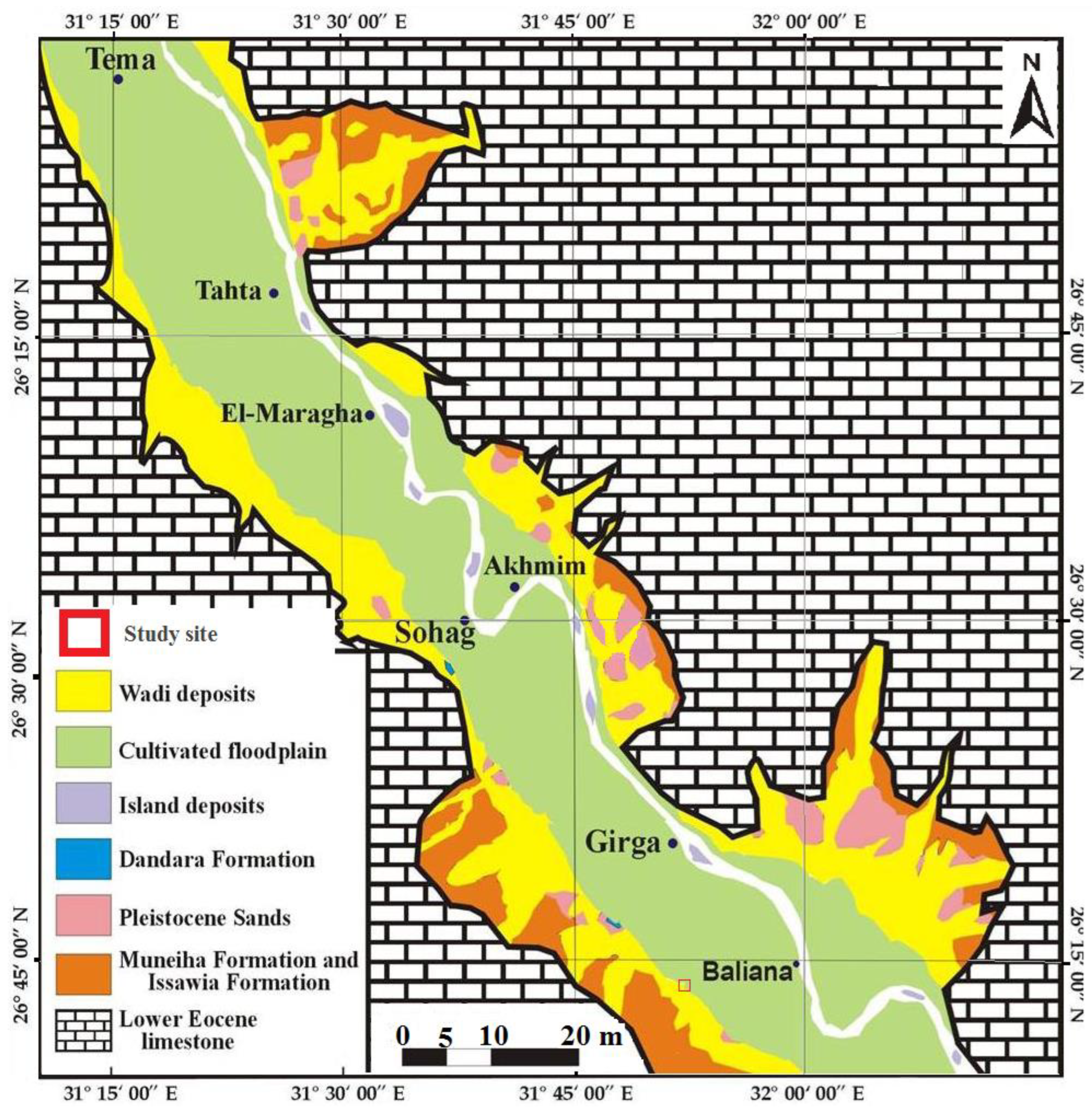
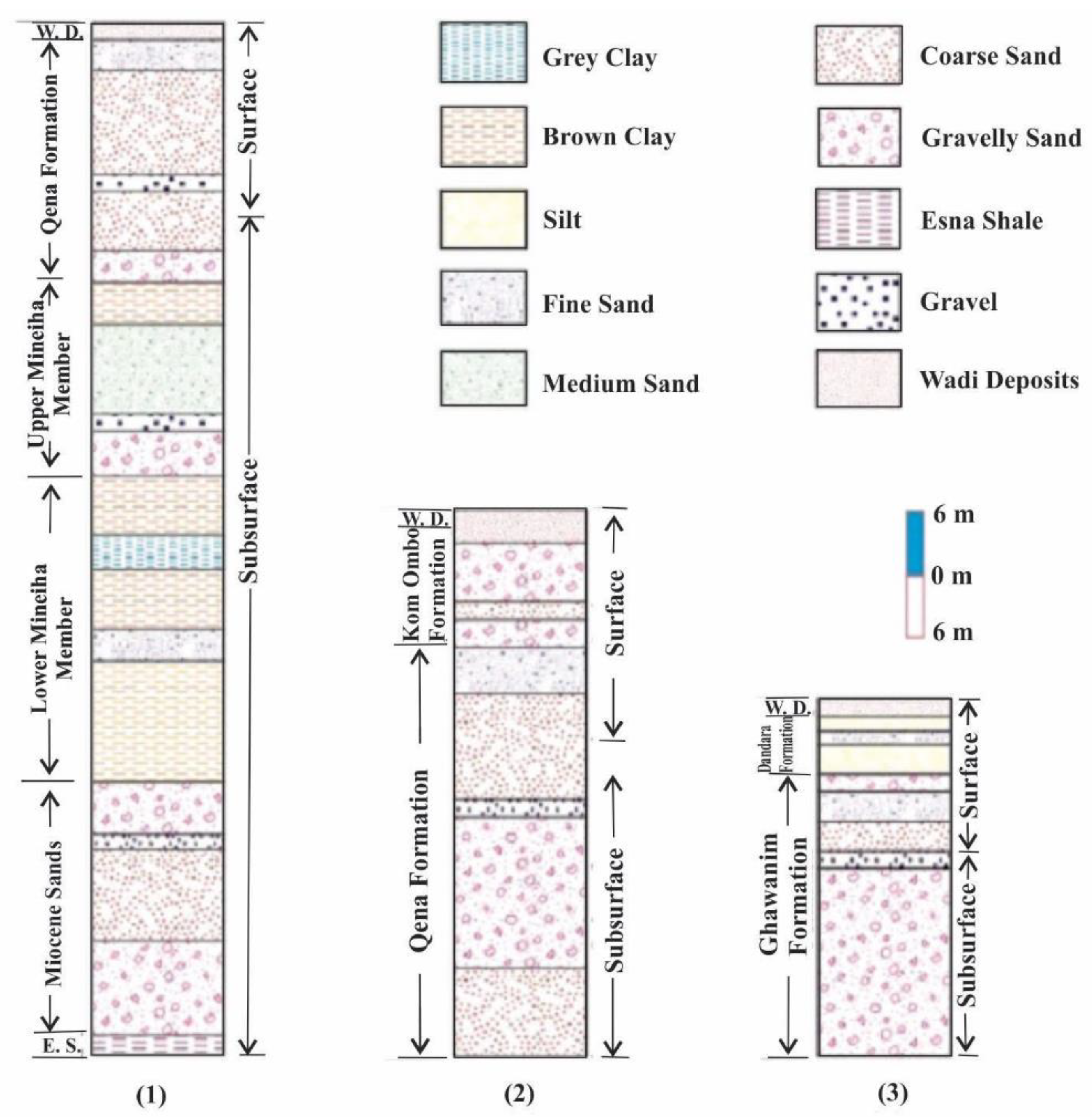
Many scientists studied geophysically and geologically the investigated site, which is located in the Sohag governorate [14,58]. In general, rock units dating from the Lower Eocene to the Recent Period are found in the Sohag governorate. Figure 2 depicts a geological map of the study site. The majority of the Abydos area is Quaternary, with Pliocene sediments unconformably covering the Esna Shale, which is Early Tertiary [59]. The Qena Formation is a dense succession of deposits of slightly indurated fluviatile sands at the section’s base [60,61]. Pliocene Clay, Qena Sands (Upper Pliocene to Lower Pleistocene), Kom Ombo Gravel, El Ghawanim Formation, and Dandara Formation are the five rock units that make up the overall lithological component of the survey area [62].
The Qena sands are the principal water-bearing structure in the examined area, as well as in most of the Nile Valley. These sands thin out as they approach the Paleocene to Lower Eocene limestone plateau in the west. Some of these sands are removed by erosion eastwards, in places along the Nile and its valley, and silt fills the current Nile and its plain. According to results from neighborhood wells in the Abydos Temple site, the stretch of Qena sands could be up to 15 m thick [63]. The sands’ base differs from one well to the next (Figure 3). The Pliocene sediments in the Upper Nile Valley are overlain by this sand sequence [64]. The Qena sands are observed to be overlain by gravel beds to the west of the Kom Ombo district [65]. Meanwhile, along the Nile’s western bank between Sohag and Assiut, the Kom Ombo Formation’s sediments are predominantly fluviatile sands with some gravel intercalations [62]. The Ghawanim Formation’s lithologic strata also include cross-bedded fluviatile sands and gravels, as well as conglomerate lenses and quartzitic sandstone interbeds.
The Dandara Formation is the top stratum of the geologic succession in the Abydos area [59]. They belong to a mineral sequence discovered in Ethiopia. Above the Kom Ombo gravels, the Dandara Formation silt appears as sedimentary strata with thicknesses ranging from a few centimeters to 5 m [66]. The silt is primarily sandy in composition, calcareous in spots, and stained to a red paleosol on top. The cultivated silts of the current Nile, which comprise the huge flood plain of Upper Egypt, truncate the previously studied sequence.
The lithological feature of the region that is a segment of the Nile Valley consists of river deposits gathered during various periods of the river’s evolution. Clay layers could be compared to Paleonile sediments, which are basal deposits over Lower Eocene limestone and are differentiated by varying clay depths with minor silt intercalation [64].
Two large faults extending NW-SE and NE-SW enclose the limestone cliff around the place, generating a prominent promontory, according to the overall structure of the Abydos region. The movement of groundwater throughout the region is influenced by these promontories [63].

4. Material and Methods

The authors gathered all existing evidence from the Egyptian Antiquities Authority regarding findings and the likelihood of undiscovered sites based on the opinions of archaeological missions in Abydos [55,56]. These data include geology, geomorphologic, and archeological maps, as well as unpublished mission scientific reports and published articles. As a reconnaissance study, a land magnetic survey was conducted on the regular grids of the studied site to identify any potential anomalies that might be artifacts from the past. These artifacts will then be extensively surveyed using GPR and the appropriate antennae.

4.1. Land Magnetic Survey

Using a Geometrics G-857 proton magnetometer, a land magnetic survey was carried out. This device is frequently used for geological structure mapping, environmental or archaeological purposes, and mining exploration [67]. The area of the investigated site is 10,000 square meters, where successive inline profiles were surveyed with a 2-m spacing, yielding 51 profiles.

4.2. Ground Penetrating Radar

Ground penetrating radar (GPR) is an electromagnetic approach that archaeologists can use in the 21st century to undertake excavations. Its purpose is to investigate the earth’s shallow subsurface, as well as bridges, canals, ancient quarries, railroads, urban structures, building supplies, cave structures, and archaeological features with considerable deeply stratified masonry relics. This will offer precise exploration depth for various subsurface structures [68]. The GPR method necessitates the transmission of electromagnetic radio (radar) signal in the form of an elliptical cone from the transmitting antenna to the ground, as well as the estimation of the time among transmission and reflections of the buried discontinuity, and reception back to the surface radar antenna (receiving antenna). Ground penetrating radar is commonly used in archaeological evidence. It’s rapid, and it allows an archaeologist to cover a large area of buried archaeological sites with high accuracy while avoiding harm to the surface. One advantage of radar scans over other archaeology approaches is that they can map the subsurface stratigraphy and archaeological aspects of a site at a true depth according to the antenna’s frequency [69].
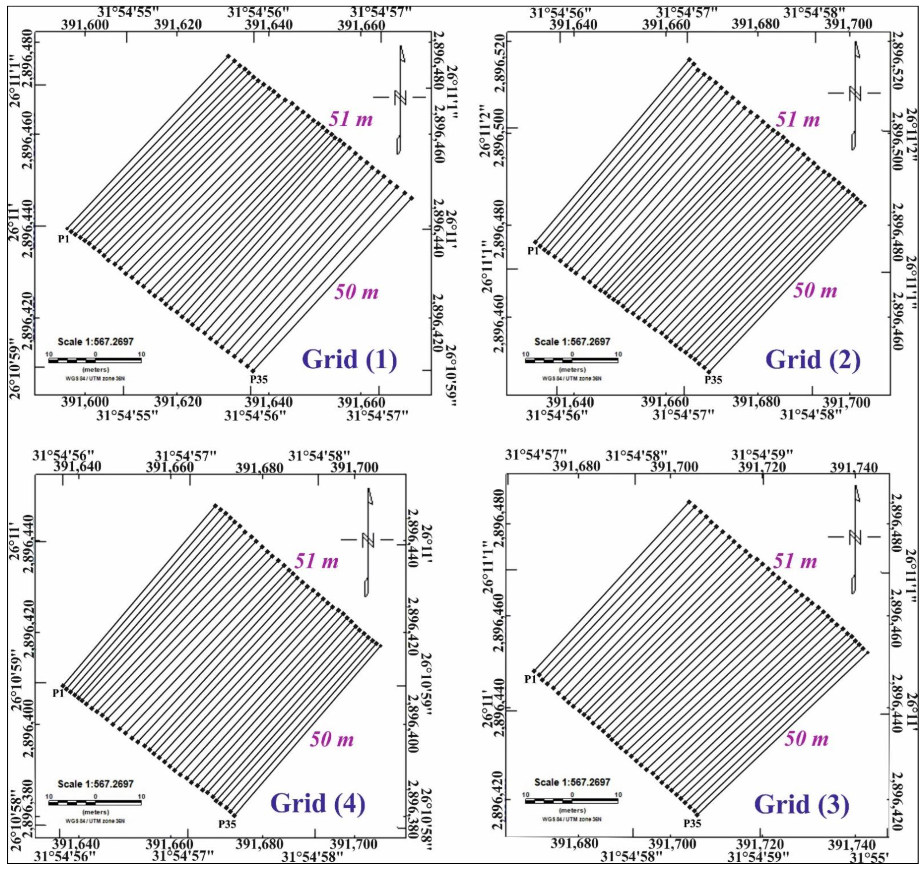
The GPR data was collected utilizing Geophysical Survey Systems Incorporation (GSSI) type SIR 4000 equipment with a central frequency antenna of 200 MHz. Sensors, control units, and connections are the critical elements of this instrument. The control system produces a high-voltage electrical signal that is delivered via cables to the transmitter, boosting the voltage and form of the pulse before it is transmitted by the antenna, maintains the system during the scan, and keeps track of the transmitter-receiver relationship [69]. The Topcon GPS receiver is used to precisely locate the coordinates of the observed sections. The data from the output is filtered, enlarged, and stored (Figure 4). This survey was carried out in two stages at the study site: reconnaissance and details surveys. A detailed survey was carried out over the prospective locations based on the results of the reconnaissance phase. As a result, the research site was divided into four grids, each measuring 50 × 51 m, where successive inline profiles were surveyed with 1.5 m spacing, yielding 35 profiles in each grid for a total of 140 profiles (Figure 5).
According to the historical background of the pre-explored tombs, the expected depth of the undiscovered archaeological features is not likely to surpass 5 m. Accordingly, the central frequency antenna of 200 MHz was used for producing high resolution images of the main potential targets. Figure 5 shows the four surveyed grids in the study site. Careful inspection of the results of all radiograms which produced from 140 profiles in all grids indicate that there are some places exhibited potential archaeological features and other placed do not exhibit any archaeological features. As a result, the areas that may have indicated archaeological features were re-surveyed using more precise grids of 11 inline and 11 crossline profiles each of them is 15 m length.

5. Data Processing

5.1. Magnetic Data Processing

The detailed description of the region can be inferred from the magnetic data independently. Processing magnetic raw data is a crucial step to highlighting some of the features identified as a tool for information interpretation. Geosoft Oasis Montaj [70] was used to process the magnetic data. The processing phases involved the application of several filters and depth estimate methods. The TMI map was filtered using Butterworth high pass (HP) filter with values of degree of filter function of 8 and cut off wavelength of 25 m, and first vertical derivative (FVD) techniques to produce two maps of shallow sources (residuals) to be valid for describing qualitatively the near surface archaeological features. On the other hand, the magnetic data was quantitatively described to estimate the depths of the archaeological features in the study site using source parameter imaging (SPI) and analytical signal (AS) techniques.

5.2. GPR Data Processing

The noise and inappropriate reflections induced by the antenna ringing, fluctuations in energy coupling with the ground, and many reflections between the antenna and the ground surface were removed using REFLEXW software version 9.1 [71]. This technique improves the required reflections while also correcting horizontal and vertical resolution [72]. Static correction, band pass frequency filter, running average, background-removing filter, gain, and so on are some of the processing steps in REFLEXW, as stated in the program’s documentation [73]. The radargram sections appear as a relation between the two-way travel times in a draped fashion and the offset distances. The radargram section that is function in time is converted into another section that is function in depth for interpretational purposes using the appropriate velocity. The velocity of the radar wave was calculated using both the reflected wave approach and the hyperbolic shape procedure in this study. The velocity which was used to convert the time into depth in this survey for all profiles was 0.107 m/ns.

6. Results and Discussion

6.1. Magnetic Results

The TMI map exhibits a variety of anomalies with low and high intensities that are dispersed over the investigated site (Figure 6a), according to the visual inspection. These anomalies have magnetic values ranging from 42,056 to 42,072 nT. These geometric shapes of the magnetic features are rectangles, elongated, and square shapes. These features may indicate the presence of tombs, chambers, and walls. These objects have diameters that range from 5 to almost 15 m. These measures correspond very well with the excavations conducted at this archaeological site [74], where multichambered mud-brick tombs of varied sizes and shapes were found. These tombs have dimensions ranging from 3 to 12 m.
TMI map was processed to separate the shallow sources of the residual magnetic component which represent the archaeological features in the current site from the regional magnetic component of the deeper objects of geological interests. For this purpose, Butterworth high pass filter was used to produce a residual map (Figure 6b). A closer look at this map reveals that positive and negative anomalies are plainly visible, with magnetic values ranging from −4.59 nT to 3.28 nT, and higher resolution than those on the TMI map. These anomalies have short-wavelength and high-frequency with rectangular, elongated, and square geometrical shapes. Based on their geometric shapes and magnetic values, these anomalies may be attributed to potential archaeological targets. The contrast between the magnetic values of the outer margins and the inner core of the geometric anomalies may be related to the disturbance of these buried as the mud-brick floor or roof may be replaced by sands or other materials of low magnetic intensity features as explained by Abbas et al. [27].
FVD map of the site (Figure 6c) explains the contact between the magnetic sources by zero contour lines, which also provides a definite illustration of the dispersion of magnetic anomalies. Positive values can be as high as 2.202 nT/m, while negative values can be as low as −3.421 nT/m. Small anomalies on the map could be attributed to shallow short-wave sources. The anomalies have diverse shapes at different sites, including square, elongated, and rectangular ones, and the results are consistent with the high pass map results.
Analytical signal values range from 0.014 up to 3.79 nT/m, as can be seen from a critical analysis of the analytical signal map (Figure 6d). The analytical signal map displays distinct gradient peaks that line up with Butterworth high pass filter estimates. Most of high analytical signal values are square or rectangular in shape, with an average radius of 5 to 10 m; nevertheless, some of these values are more than 25 m in length. It is a process for automatically calculating source depth from TMI data (Figure 6e). The maximum depths for magnetic sources in this map range from 1.03 to 2.28 m.
Finally, it can be stated that the comparison between all maps shows a great similarity in shape and position of most of the enhanced features such as boundaries of the geometric shapes and their positions. The depths to magnetic features range from 1.03 m to ≈ 3 m in maximum depths which mean that all features are shallow and corresponding with other excavations in nearby sites.

6.2. GPR Results

The position of the sources of the anomalies that appear on the radargram sections must be distinguished from other multiple reflections. Any anomaly in the radargram section should be evaluated in a successive of inline and crossline sections within the area, with the hyperbolas for this anomaly on the radargram sections having the highest amplitude on the section exactly above center of the source of the anomaly and this amplitude will decrease as the center of the source moves outward.
A careful examination of radargrams in each grid explained that some 2D sections contain potential targets, while other ones do not contain any important targets, and therefore, they have been neglected in the upcoming description.
The result of all radargrams revealed that there are eight potential targets of definite hyperbole of considerable amplitudes that may be related to archaeological features. [20,29] studied similar sites in Egypt and they interpreted similar anomalies as archeological objected, their results are matching well with our findings.
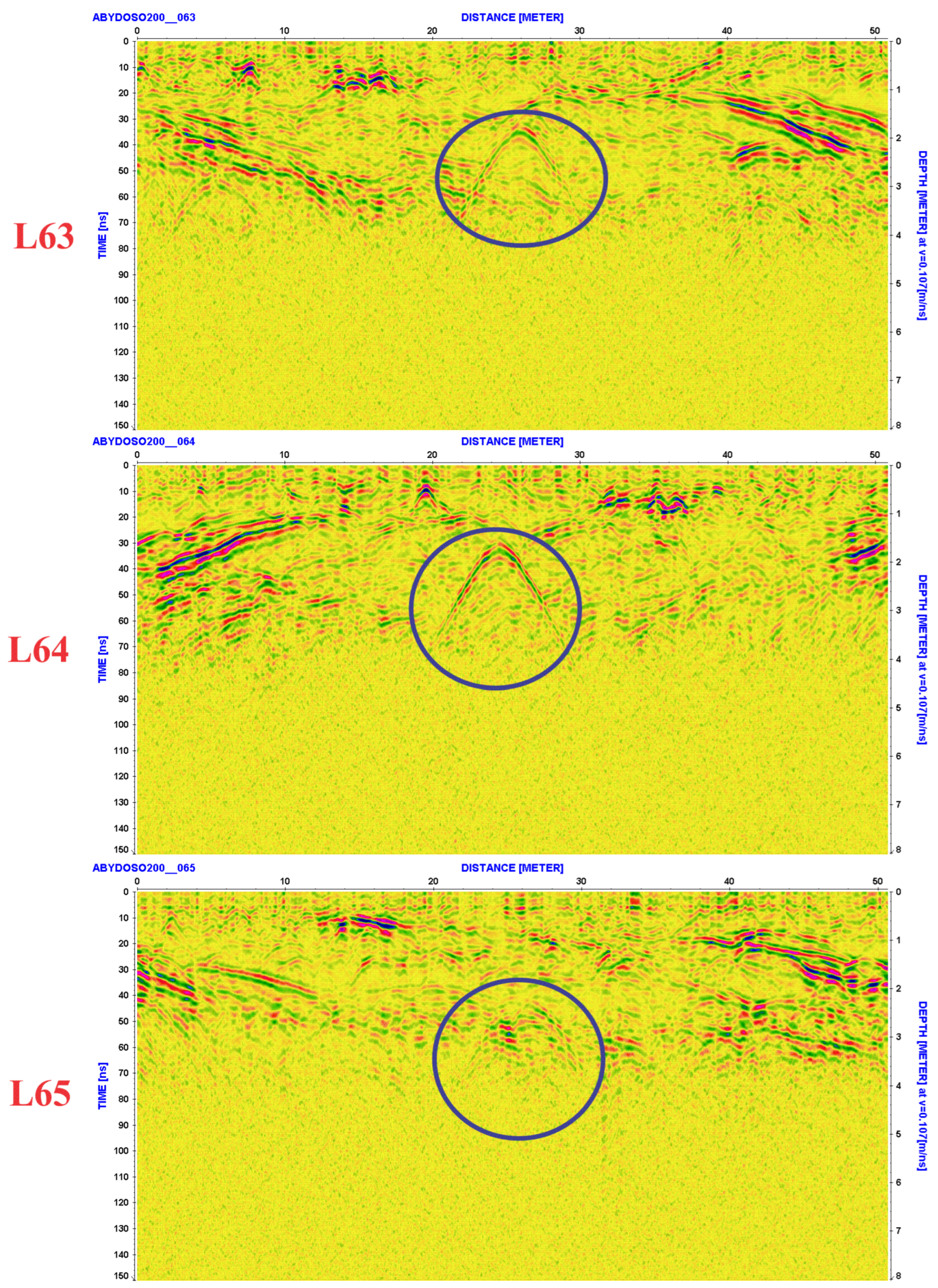
To make this article’s length reasonable, only one hyperbola in the grid No. (3) was discussed in detail. Figure 7 shows three successive profiles L63, L64, and L65 during reconnaissance survey which has lengths of 50 m. In each profile, there is a definite hyperbola in the 2D radargram. In line No. 63, the horizontal dimension of this hyperbola begins from the offset 20 m to 31 m with a maximum distance 11 m and the two-way time (TWT) of its top is 30 ns and the depths to its top and bottom are 1.7 m and 3.8 m, respectively, giving an amplitude of 2.1 m. Line 64 reveals the same hyperbola which occurred in line 63 with the same horizontal dimension (11 m) but its amplitude enlarged to be 2.3 m where its top and bottom occurred at depths 1.6 m to 3.9 m. Line 65 showed the hyperbola as in the former lines with the same horizontal dimension (11 m) but its amplitude changed to be 2.1 m where the depth to the top and the bottom are 1.8 m and 3.9 m, respectively.
Comparison of the three lines, we can conclude that the highest amplitude of the source body forming this hyperbola occur beneath the line No. 64. This indicates that the center of this source is beneath this location. The amplitude of this anomaly decreases toward the line 63 and 65. The depth to the top of this source is 1.6 m and to the bottom is 3.9 m
After inspection of the reconnaissance line No. 63, 64 and 65 which found out presence of an archaeologic object may be a tomb, the detail lines are subtracted to reveal only the dimension of this object. So, 22 inline and crossline profiles were surveyed over this promising location.
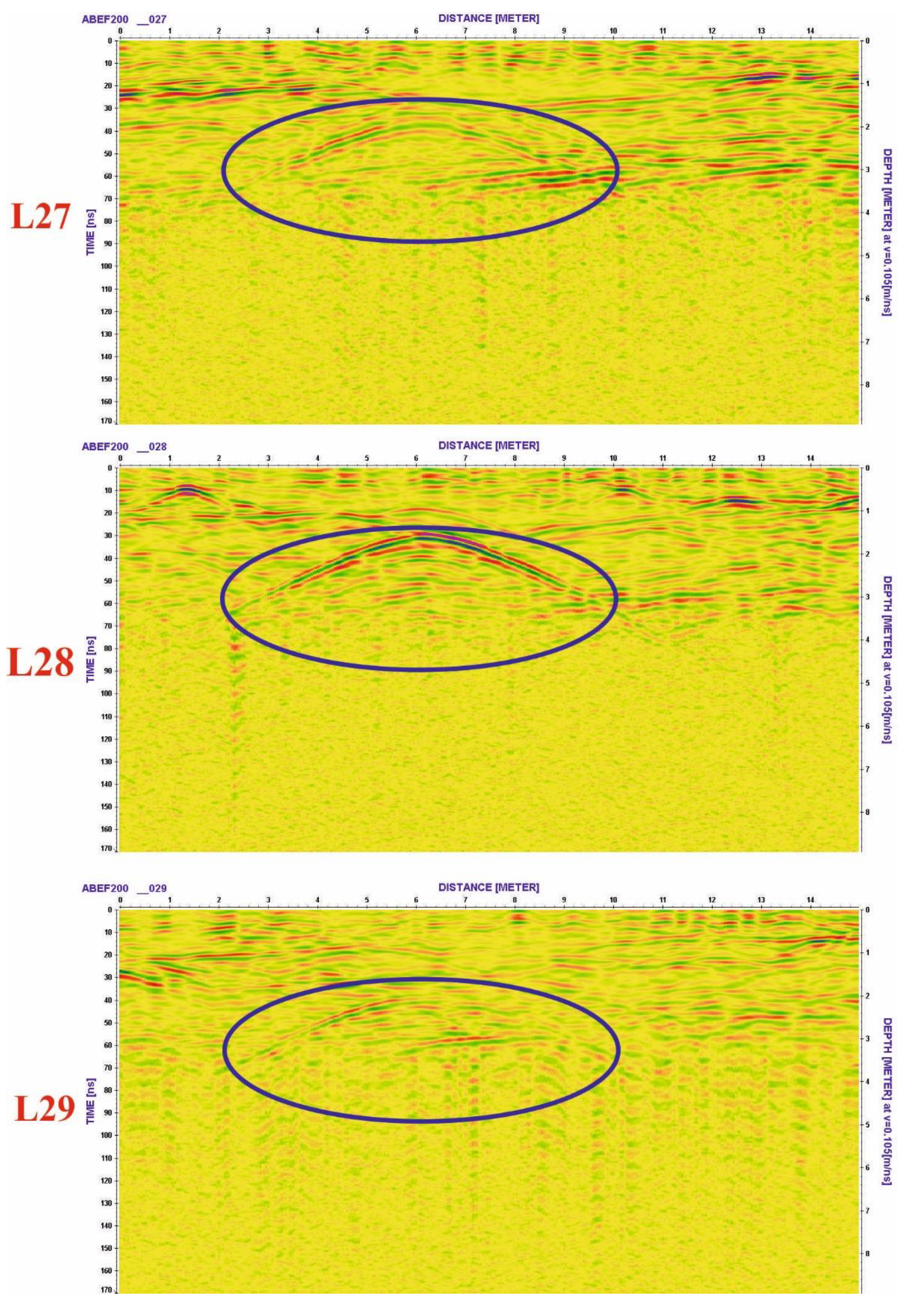
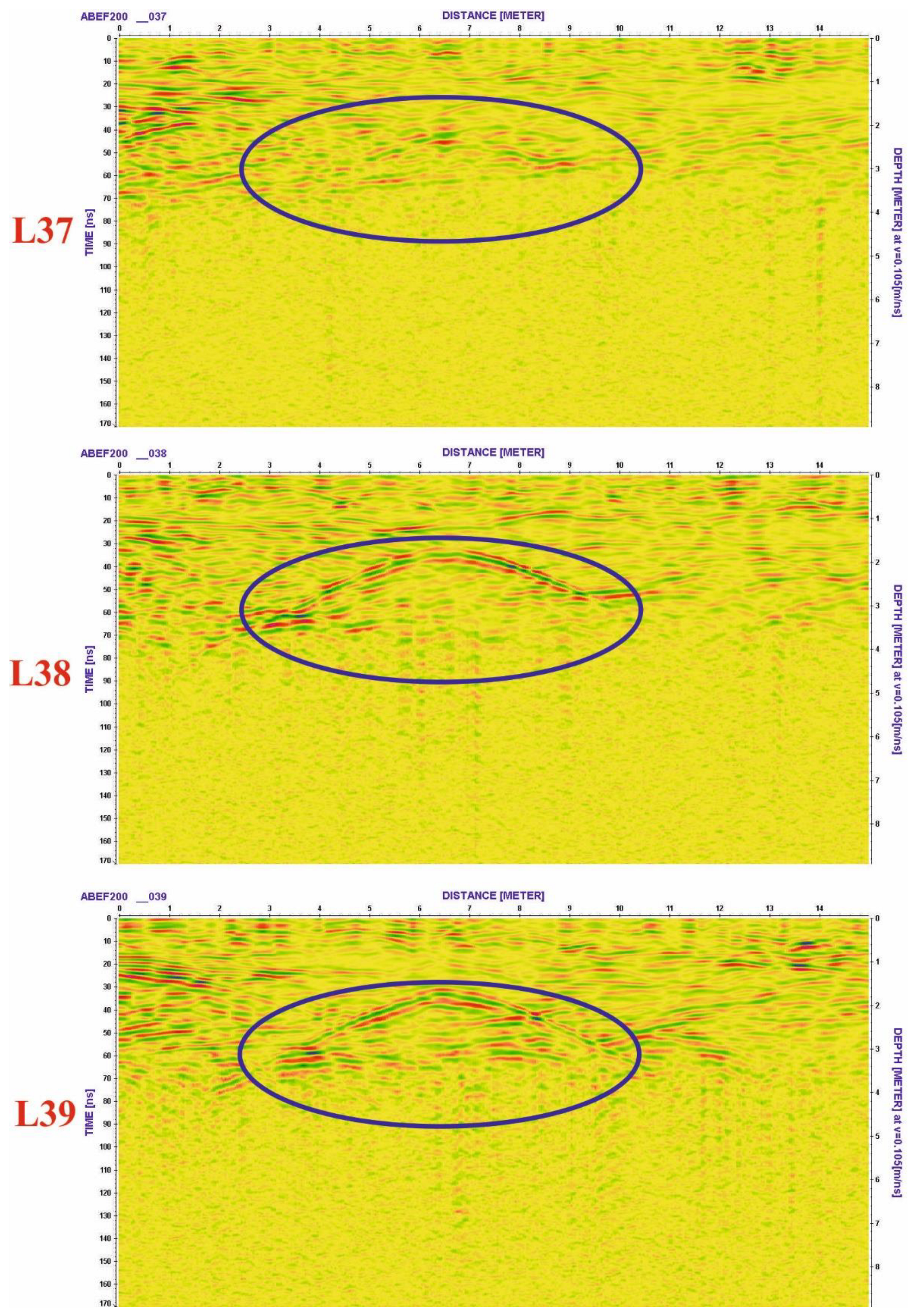
Figure 8 exhibits three consecutive inline profiles (L27, L28, and L29) of length 15 m and Figure 9 depicts three consecutive crossline profiles (L37, L38, and L39) of length 15 m.
Inspection of the inline profiles (L27, L28, and L29), Figure 8 reveals the same conclusion which deduced from the former profiles (L63, 64, and 65) where the depth to the top and the bottom of the source body forming the hyperbola in these profiles is ranging between 1.6 and 3.9 m. Line 28 shows the maximum amplitude for this anomaly (2.3 m) indicating that its center is more or less beneath this location. Examination of the crossline profiles (L37, L38, and L39), Figure 9 reveals also the same results concerning the amplitude, the dimension and the depth of the source body forming the anomaly. However, its top may be shifted toward line No. 37 which reveals minimum amplitude. The top and the bottom of the source body in these profiles are still at the same depths deducing from the inline profiles (1.6 for the top and 3.9 for the bottom). This source body may be indicating an ancient remnant or maybe buried chamber (tomb) in general at the top depth do not exceed 2 m and its bottom do not exceed 4 m.
Finally, the GPR results revealed eight significant archaeological objects in the study site, each of which has defined considerable dimension and depth beneath the ground surface, which may indicate ancient archaeological targets as chambers (tombs) buried at depths ranging from 2 to 4 m for their tops and bottoms.
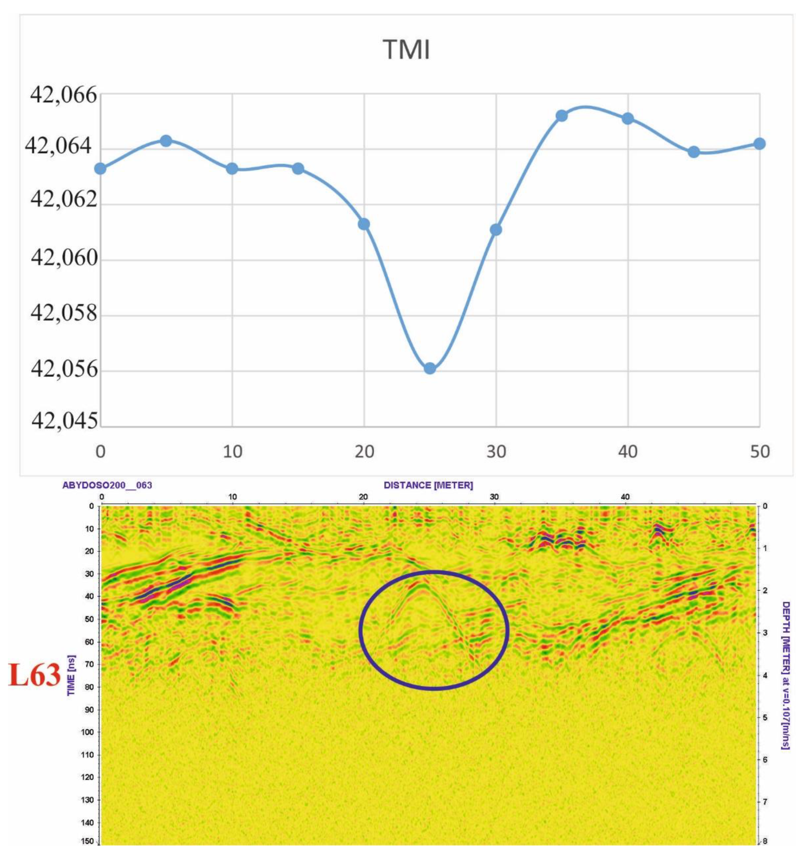
The integration of the magnetic and GPR results revels that there is an agreement in the mapping of the location of the potential buried archaeological targets, which have depths ranging from 1 m to 4 m. Figure 10 shows correlation between the 2D cross sections of the magnetic data and GPR for the same profile (L63) which reveals a good matching between the magnetic anomaly and the hyperbola of radargram. By combining magnetic and GPR results, it is possible to determine the locations of potential buried archaeological targets. Figure 11 illustrates the locations of buried targets with various shape, dimension, and depth from both magnetic and GPR results. It basically entails excavation at these places to confirm these findings. However, we were unable to excavate at these locations currently because of security reasons. However, Sohag University President sent a request to the Egyptian Antiquities Ministry for taking the permission to excavate at the Abydos site. We are awaiting these authorizations.

7. Conclusions

Abydos archaeological site is regarded as one of the most famous Egyptian ancient sites for prominent tourist destinations. This location has a lot of discovered monuments. So, the main objective of this work is an attempt to investigate this site for unearthed archaeological objects such as ancient walls, tombs, relics. This goal was realized using modern near surface geophysical tools. Ground magnetic and GPR surveys were implemented in this site and the results of these surveys were processed and interpreted using suitable software. The results with those inferred from the excavation close to this site supported the findings.
The total magnetic intensity (TMI) anomaly map deduced from the magnetic survey was filtered to residual component of shallow sources for the magnetic field by Butterworth high pass (HP) filter and first vertical derivative (FVD). The magnetic results were interpreted qualitatively and quantitatively to describe locations, shapes, sizes, and depths of these magnetic anomalies which may represent archaeological objects. Magnetic results reveal that this site contains different anomalies which have geometric shapes (rectangles, elongated, and squares shapes). The estimated depths of these objects using source parameter imaging (SPI) and analytical signal (AS) techniques are between 1–3 m.
The GPR results exhibit eight distinct hyperbolas in different locations within Abydos site which were interpreted as archaeological features by comparable with those deduced from magnetic findings mentioned to the excavation results in and near the study site. The main depth of these targets is between 2–4 m and was interpreted as buried shallow tombs. Therefore, the final potential results from both magnetic and GPR techniques are presence of eight potential targets attributed to archeological features with depths from 1–4 m. These findings will have an impact on local and international tourism in Egypt, resulting in an increase in the number of tourists and a rise in national income.

Author Contributions

Conceptualization, A.M.A.; data curation, M.M.M.; formal analysis, M.A.M.; investigation, A.M.A., G.Z.A.A. and M.A.M.; methodology, M.M.M. and M.A.M.; software, G.Z.A.A.; writing—original draft, M.A.M.; writing—review and editing, A.M.A., G.Z.A.A. and M.M.M. All authors have read and agreed to the published version of the manuscript.

Funding

This research was funded by the Science, Technology, and Innovation Funding Authority (STIFA) of Egypt, grant number 37087.

Data Availability Statement

The data is available upon request from the authors.

Acknowledgments

Many thanks for the Science, Technology and Innovation Funding Authority (STIFA), Egypt for funding this paper where it is a part of a project funded by them with ID Number (37087). Many thanks also for the Egyptian Antiquities Authority which gave us the permissions to implement the fieldwork.

Conflicts of Interest

The authors declare no conflict of interest.

References

  1. El All, E.A.; Khalil, A.; Rabeh, T.; Osman, S. Geophysical contribution to evaluate the subsurface structural setting using magnetic and geothermal data in El-Bahariya Oasis, Western Desert, Egypt. NRIAG J. Astron. Geophys. 2015, 4, 236–248. [Google Scholar] [CrossRef]
  2. Abbas, A.M.; Kamei, H.; Helal, A.; Atya, M.A.; Shaaban, F.A. Contribution of geophysics to outlining the foundation structure of the Islamic Museum, Cairo, Egypt. Archaeol. Prospect. 2005, 12, 167–176. [Google Scholar] [CrossRef]
  3. Tzanis, A. MatGPR (Release 3), Manual and Technical Reference; University of Athens; Department of Geophysics: Athens, Greece, 2013. [Google Scholar]
  4. Daniels, D.J. Surface-penetrating radar. Electron. Commun. Eng. J. 1996, 8, 165–182. [Google Scholar] [CrossRef]
  5. Davis, J.L.; Annan, A.P. Ground-penetrating radar for high-resolution mapping of soil and rock stratigraphy 1. Geophys. Prospect. 1989, 37, 531–551. [Google Scholar] [CrossRef]
  6. Gaber, H.A.; Abudeif, A.M.; Mohammed, M.A.; AbdelAal, G.Z.; Mansour, K.K. Archaeological prospecting on the site of Osirion-Abydos using High Resolution Ground Penetrating Radar Technique, Sohag District, Egypt. Sohag J. Sci. 2022, 7, 115–122. [Google Scholar]
  7. Mohammed, M.A.; Abudeif, A.M.; AbdelAal, G.Z.; Gaber, H.A. Archaeogeophysical study on the Abydos Temple site using Ground Penetrating Radar Technique, Sohag Governorate, Egypt. In Proceedings of the Fifth International Conference on New Horizons in Basic and Applied Sciences. Organized by Faculty of Science (Assiut) Al-Azhar University, Hurghada, Egypt, 26–29 September 2021. [Google Scholar]
  8. El Emam, A.; Lethy, A.; Radwan, A.M.; Awad, A. Archaeological investigation and hazard assessment using magnetic, ground-penetrating radar, and GPS tools at Dahshour Area, Giza, Egypt. Front. Earth Sci. 2021, 9, 674953. [Google Scholar] [CrossRef]
  9. Derda, T.; Gwiazda, M.; Misiewicz, K.; Małkowski, W. Marea/Northern Hawwariya in northern Egypt: Integrated results of non-invasive and excavation works. Archaeol. Prospect. 2021, 28, 123–136. [Google Scholar] [CrossRef]
  10. Yousef, S.B.; Yousef, M.H.; Abd-Elsalam, H.F.; Shaheen, M.A. Detection of the Possible Buried Archeological Targets Using the Geophysical Methods of Ground Penetrating Radar (GPR) and Self Potential (SP), Kom Ombo Temple, Aswan Governorate, Egypt. Geomaterials 2020, 10, 105. [Google Scholar] [CrossRef]
  11. Mohamed, A.-M.S.; Atya, M.; AbouAly, N.; Farragawy, K.E.; Hegazy, E.E.; Saleh, M.; Kabeel, K.; El-Mahdi, A.A. Mapping the archaeological relics of catacombs at Northeast Saqqara using GPR data, Egypt. NRIAG J. Astron. Geophys. 2020, 9, 362–374. [Google Scholar] [CrossRef]
  12. Ibrahim, H.A.; Ebraheem, M.O. Ground-penetrating radar reflections and their archaeological significances at two ancient necropolis tombs in Kharga Oasis, Egypt. Near Surf. Geophys. 2020, 18, 713–728. [Google Scholar] [CrossRef]
  13. Ahmed, S.B.; El Qassas, R.A.; El Salam, H.F.A. Mapping the possible buried archaeological targets using magnetic and ground penetrating radar data, Fayoum, Egypt. Egypt. J. Remote Sens. Space Sci. 2020, 23, 321–332. [Google Scholar] [CrossRef]
  14. Mohammed, M.; Abudeif, A. Applications of electrical resistivity for construction in Al Kawamil, Sohag, Egypt: A case study. J. Environ. Eng. Geophys 2019, 24, 327–332. [Google Scholar] [CrossRef]
  15. El-Qady, G.; Metwaly, M.; Drahor, M.G. Geophysical techniques applied in archaeology. In Archaeogeophysics; Springer: Berlin/Heidelberg, Germany, 2019; pp. 1–25. [Google Scholar]
  16. Gaber, A.; El-Qady, G.; Khozym, A.; Abdallatif, T.; Kamal, S.A. Indirect preservation of Egyptian historical sites using 3D GPR survey. Egypt. J. Remote Sens. Space Sci. 2018, 21, S75–S84. [Google Scholar] [CrossRef]
  17. Gaballah, M.; Grasmueck, M.; Sato, M. Characterizing subsurface archaeological structures with full resolution 3D GPR at the early dynastic foundations of Saqqara Necropolis, Egypt. Sens. Imaging 2018, 19, 1–15. [Google Scholar] [CrossRef]
  18. Hemeda, S.; Pitilakis, K. Geophysical investigations at Cairo’s oldest, the church of Abu Serga (st. sergius), Cairo, Egypt. Res. Nondestruct. Eval. 2017, 28, 123–149. [Google Scholar] [CrossRef]
  19. Gavazzi, B.; Alkhatib-Alkontar, R.; Munschy, M.; Colin, F.; Duvette, C. On the use of Fluxgate 3-Axis magnetometers in archaeology: Application with a multi-sensor device on the site of Qasr ‘Allam in the Western Desert of Egypt. Archaeol. Prospect. 2017, 24, 59–73. [Google Scholar] [CrossRef]
  20. Abbas, A.M.; Ghazala, H.H.; Mesbah, H.S.; Atya, M.A.; Radwan, A.; Hamed, D.E. Implementation of ground penetrating radar and electrical resistivity tomography for inspecting the Greco-Roman Necropolis at Kilo 6 of the Golden Mummies Valley, Bahariya Oasis, Egypt. NRIAG J. Astron. Geophys. 2016, 5, 147–159. [Google Scholar] [CrossRef]
  21. Abbas, A.M.; Salah, H.; Massoud, U.; Fouad, M.; Abdel-Hafez, M. GPR scan assessment at Mekaad Radwan Ottoman–Cairo, Egypt. NRIAG J. Astron. Geophys. 2015, 4, 106–116. [Google Scholar] [CrossRef]
  22. El Emam, A.; Abdallatif, T.; Suh, M.; Odah, H. Delineation of Egyptian mud bricks using magnetic gradiometer techniques. Arab. J. Geosci. 2014, 7, 489–503. [Google Scholar] [CrossRef]
  23. Odah, H.; Ismail, A.; Elhemaly, I.; Anderson, N.; Abbas, A.M.; Shaaban, F. Archaeological exploration using magnetic and GPR methods at the first court of Hatshepsut Temple in Luxor, Egypt. Arab. J. Geosci. 2013, 6, 865–871. [Google Scholar] [CrossRef]
  24. Mekkawi, M.; Arafa-Hamed, T.; Abdellatif, T. Detailed magnetic survey at Dahshour archeological sites Southwest Cairo, Egypt. NRIAG J. Astron. Geophys. 2013, 2, 175–183. [Google Scholar] [CrossRef] [Green Version]
  25. Atya, M.; Al Khateeb, S.; Ahmed, S.; Musa, M.; Gaballa, M.; Abbas, A.; Shaaban, F.; Hafez, M. GPR investigation to allocate the archaeological remains in Mut temple, Luxor, Upper Egypt. NRIAG J. Astron. Geophys. 2012, 1, 12–22. [Google Scholar] [CrossRef]
  26. Abbas, A.M.; Atya, M.; El Emam, A.; Shaaban, F.F.; Odah, H.H.; Lethy, A.M. Integrated Geophysical Studies to Image the Remains of Amenemeht II Pyramid’s Complex in Dahshour Necropolis, Giza, Egypt. J. Pet. Min. Eng 2011, 14, 27–51. [Google Scholar]
  27. Abbas, A.M.; Abdallatif, T.F.; Shaaban, F.A.; Salem, A.; Suh, M. Archaeological investigation of the eastern extensions of the Karnak Temple using ground-penetrating radar and magnetic tools. Geoarchaeology:Int. J. 2005, 20, 537–554. [Google Scholar] [CrossRef]
  28. Khozym, A. Geophysical Prospection of Some Archaeological Sites in Saqqara Area, Giza, Egypt. Unpublished Master’s Thesis, Ain Shams University, Cairo, Egypt, 2003. [Google Scholar]
  29. Ismail, A.M.A. Geophysical, Hydrological, and Archaeological Investigation in the East Bank Area of Luxor-Southern Egypt; University of Missouri-Rolla: Rolla, MO, USA, 2003. [Google Scholar]
  30. Ghazala, H.; El-Mahmoudi, A.; Abdallatif, T. Archaeogeophysical study on the site of Tell Toukh El-Qaramous, Sharkia Governorate, East Nile Delta, Egypt. Archaeol. Prospect. 2003, 10, 43–55. [Google Scholar] [CrossRef]
  31. Kamei, H.; Atya, M.A.; Abdallatif, T.F.; Mori, M.; Hemthavy, P. Ground-penetrating radar and magnetic survey to the west of Al-Zayyan Temple, Kharga Oasis, Al-Wadi Al-Jadeed (New Valley), Egypt. Archaeol. Prospect. 2002, 9, 93–104. [Google Scholar] [CrossRef]
  32. Elbassiony, A. Geophysical Archaeoprospection in Saqqara and Qantir Areas, Egypt. Unpublished Master’s Thesis, Ain Shams University, Cairo, Egypt, 2001. [Google Scholar]
  33. Shaaban, F.; Shaaban, F.; Abbas, A.; El-Essawy, A. Mapping of buried archaeological relics using GPR survey at the Isis Temple, Bahbeit El-Hegara Area, Egypt. In Bulletin of National Research Institute of Astronomy and Geophysics (NRIAG); NRIAG Journal of Astronomy and Geophysics: Cairo, Egypt, 2003; pp. 111–133. [Google Scholar]
  34. Rhee, J.-Y.; Park, K.-T.; Cho, J.-W.; Lee, S.-Y. A Study of the Application and the Limitations of GPR Investigation on Underground Survey of the Korean Expressways. Remote Sens. 2021, 13, 1805. [Google Scholar] [CrossRef]
  35. Leucci, G.; De Giorgi, L.; Ditaranto, I.; Miccoli, I.; Scardozzi, G. Ground-Penetrating Radar Prospections in Lecce Cathedral: New Data about the Crypt and the Structures under the Church. Remote Sens. 2021, 13, 1692. [Google Scholar] [CrossRef]
  36. Forte, E.; Mocnik, A.; Basso, P.; Casagrande, G.; Martinucci, D.; Pillon, S.; Possamai, M.; Zambrini, R. Optimised extraction of archaeological features from full 3-d gpr data. Appl. Sci. 2021, 11, 8517. [Google Scholar] [CrossRef]
  37. Verdonck, L.; Launaro, A.; Vermeulen, F.; Millett, M. Ground-penetrating radar survey at Falerii Novi: A new approach to the study of Roman cities. Antiquity 2020, 94, 705–723. [Google Scholar] [CrossRef]
  38. Solla, M.; Fransisco, C.; Gonçalves, L.; Gonçalves, G.; Puente, I.; Providência, P.; Gaspar, F.; Puente, I.; Rodrigues, H. Integrating GPR and Geomatic Data into a Building Information Modelling: The Case Study of the Monastery of Batalha (Portugal); Defense University Center (Spanish Naval Academy): Marín, Spain, 2020. [Google Scholar]
  39. Ristić, A.; Govedarica, M.; Pajewski, L.; Vrtunski, M.; Bugarinović, Ž. Using ground penetrating radar to reveal hidden archaeology: The case study of the Württemberg-Stambol Gate in Belgrade (Serbia). Sensors 2020, 20, 607. [Google Scholar] [CrossRef] [PubMed]
  40. Yilmaz, S.; Balkaya, Ç.; Cakmak, O.; Oksum, E. GPR and ERT explorations at the archaeological site of Kılıç village (Isparta, SW Turkey). J. Appl. Geophys. 2019, 170, 103859. [Google Scholar] [CrossRef]
  41. Ortega-Ramírez, J.; Bano, M.; de Larrea-López, L.L.; Robles-Camacho, J.; Ávila-Luna, P.; Villa-Alvarado, L. GPR measurements to identify cracks and textural arrangements in the altar wall of the 16th-century Santa Maria Huiramangaro Church, Michoacán, Mexico. Near Surf. Geophys. 2019, 17, 247–261. [Google Scholar] [CrossRef]
  42. Casas, A.; Cosentino, P.L.; Fiandaca, G.; Himi, M.; Macias, J.M.; Martorana, R.; Muñoz, A.; Rivero, L.; Sala, R.; Teixell, I. Non-invasive geophysical surveys in search of the Roman Temple of Augustus under the Cathedral of Tarragona (Catalonia, Spain): A case study. Surv. Geophys. 2018, 39, 1107–1124. [Google Scholar] [CrossRef]
  43. Welc, F.; Mieszkowski, R.; Lipovac-Vrkljan, G.; Konestra, A. An attempt to integration of different geophysical methods (magnetic, GPR and ERT); a case study from the late Roman settlement on the Island of Rab in Croatia. Studia Quat. 2017, 34, 47–59. [Google Scholar] [CrossRef]
  44. Vanvalkenburgh, P.; Walker, C.P.; Sturm, J.O. Gradiometer and ground-penetrating radar survey of two reducción settlements in the Zaña Valley, Peru. Archaeol. Prospect. 2015, 22, 117–129. [Google Scholar] [CrossRef]
  45. Mohamad, M.H.; Nawawi, M.; Adlan, M.N.; Abdullah, K. Studying Effect of Riverbank Filtration (RBF) on Ground Water Using ‘Time-Lapse Electrical Resistivity Imaging’at Kuala Kangsar, Perak. Appl. Mech. Mater. 2015, 802, 605–610. [Google Scholar] [CrossRef]
  46. Cella, F.; Fedi, M. High-resolution geophysical 3D imaging for archaeology by magnetic and EM data: The case of the iron age settlement of Torre Galli, Southern Italy. Surv. Geophys. 2015, 36, 831–850. [Google Scholar] [CrossRef]
  47. Ekinci, Y.L.; Balkaya, Ç.; Şeren, A.; Kaya, M.A.; Lightfoot, C.S. Geomagnetic and geoelectrical prospection for buried archaeological remains on the Upper City of Amorium, a Byzantine city in midwestern Turkey. J. Geophys. Eng. 2014, 11, 015012. [Google Scholar] [CrossRef]
  48. Sarris, A.; Papadopoulos, N. Looking for graves: Geophysical Prospection of cemeteries. In Proceedings of the 16th International Congress on “Cultural Heritage and New Technologies”, Vienna, Austria, 14–16 November 2012. [Google Scholar]
  49. Alashloo, S.M.; Saad, R.; Nawawi, M.; Saidin, M.; Alashloo, M. Magnetic and 2D electrical imaging methods to investigate an archaeological site at Sungai Batu, Kedah, Malaysia. In Proceedings of the 3rd International Conference on Chemical, Biological and Environmental Engineering, IPCBEE, Chengdu, China, 23–25 September 2011. [Google Scholar]
  50. Nuzzo, L.; Leucci, G.; Negri, S. GPR, ERT and magnetic investigations inside the Martyrium of St Philip, Hierapolis, Turkey. Archaeol. Prospect. 2009, 16, 177–192. [Google Scholar] [CrossRef]
  51. Mori, G. The Use of Ground Penetrating Radar and Alternative Geophysical Techniques for Assessing Embankments and Dykes Safety. Ph.D. Thesis, Alma Mater Studiorum University of Bologna, Bologna, Italy, 2009. [Google Scholar]
  52. Schmidt, A. Archaeology, magnetic methods. In Encyclopedia of Geomagnetism and Paleomagnetism; Springer: Berlin/Heidelberg, Germany, 2007; pp. 23–31. [Google Scholar]
  53. Rizzo, E.; Chianese, D.; Lapenna, V. Magnetic, GPR and geoelectrical measurements for studying the archaeological site of ‘Masseria Nigro’(Viggiano, southern Italy). Near Surf. Geophys. 2005, 3, 13–19. [Google Scholar] [CrossRef]
  54. Abdel-Hafez, T. Geophysical and Geotechnical Studies in Pharaonic and Urban Egypt; Citeseer; Bern University: Bern, Swiss, 2004. [Google Scholar]
  55. UNESCO. World Heritage Centre.mht. In Abydos, City of Pilgrimage of the Pharaohs; WHC-03/27.COM/24; UNESCO: Paris, France, 2003. [Google Scholar]
  56. Hawass, Z. New Discoveries at Abydos; Horus Magazine Edition January/March; The American University in Cairo Press: Cairo, Egypt, 1998; pp. 392–400. [Google Scholar]
  57. Baedeker, S. Egypt from A to Z. Handbook for Travellers; Jarrold and Sons Ltd.: Cairo, Egypt, 1978. [Google Scholar]
  58. Abudeif, A.; Fat-Helbary, R.; Mohammed, M.; El-Khashab, H.; Masoud, M. Estimation of the site effect using microtremor technique at new Akhmim city, Akhmim, Sohag, Egypt. Russ. Geol. Geophys. 2019, 60, 231–239. [Google Scholar] [CrossRef]
  59. Brooks, J.E.; Issawi, B. Groundwater in the Abydos Areas, Egypt; The Flooding of the Osireion: Egyptian Journal of Archaeological and Restoration Studies “EJARS”: Cairo, Egypt, 1992. [Google Scholar]
  60. Wendorf, F.; Schild, R. Prehistory of the Nile valley; Academic Press: Cambridge, MA, USA, 2014. [Google Scholar]
  61. Said, R.; Wendorf, F.; Schild, R. The geology and prehistory of the Nile Valley in Upper Egypt. Archaeol. Pol. 1970, 12, 43–60. [Google Scholar]
  62. Omer, A. Geological, Mineralogical and Geochemical Studies on the Neogene and Quaternary Nile Basin Deposits, Qena-Assiut Stretch, Egypt. Ph.D. Thesis, South Valley University, Sohag, Egypt, 1996. [Google Scholar]
  63. Abdel Moneim, A. Groundwater studies in and around Abydos Temples, Upper Egypt. Jour. Geol. Survey Egypt 1999, 22, 357–368. [Google Scholar]
  64. Said, R. The geological Evolution of River Nile; Spring-Verlag: New York, NY, USA, 1981. [Google Scholar]
  65. Issawi, B.; Hinnawi, M. Contribution to the geology of the plain west of the Nile between Aswan and Kom Ombo. In Loaves and Fishes: The Prehistory of Wadi Kubbaniya; Southern Methodist University Press: Dallas, TX, USA, 1980; pp. 311–330. [Google Scholar]
  66. Hassan, F.A. Heavy minerals and the evolution of the modern Nile. Quat. Res. 1976, 6, 425–444. [Google Scholar] [CrossRef]
  67. Geometrics. Portable Proton-Precession Magnetometer (G-857), Operation Manual; Geometrics, Inc.: San Jose, CA, USA, 2014. [Google Scholar]
  68. Daniels, J.J.; Brower, J.; Baumgartner, F. High resolution GPR at Brookhaven National Laboratory to delineate complex subsurface targets. J. Environ. Eng. Geophys. 1998, 3, 1–5. [Google Scholar] [CrossRef]
  69. Conyers, L.B.; Goodman, D. Ground-Penetrating Radar: An Introduction for Archaeologists; AltaMira Press: Lanham, MD, USA, 1997. [Google Scholar]
  70. Geosoft. Geosoft Oasis Montaj 8.3.3 Mapping and Processing System; Geosoft Inc.: Toronto, ON, Canada, 2015. [Google Scholar]
  71. Sandmeier, K. Program for processing and interpretation of reflection and transmission data, D-76227 Karlsruha, Germany. In Guide and Manual of the Processing Program REFLEX; Sandmeier: Karlsruhe, Germany, 2001. [Google Scholar]
  72. Conyers, L.B.; Ernenwein, E.G.; Bedal, L.-A. Ground-penetrating radar discovery at Petra, Jordan. Antiquity 2002, 76, 339–340. [Google Scholar] [CrossRef]
  73. Manual, R. Windows™ XP/7/8/10-Program for the Processing of Seismic, Acoustic or Electromagnetic Reflection, Refraction and Transmission Data, Version 9.5; Sandmeier: Karlsruhe, Germany, 2020. [Google Scholar]
  74. Hossein, Y.M. A New Archaic Period Cemetery at Abydos; IFAO: Cairo, Egypt, 2011. [Google Scholar]
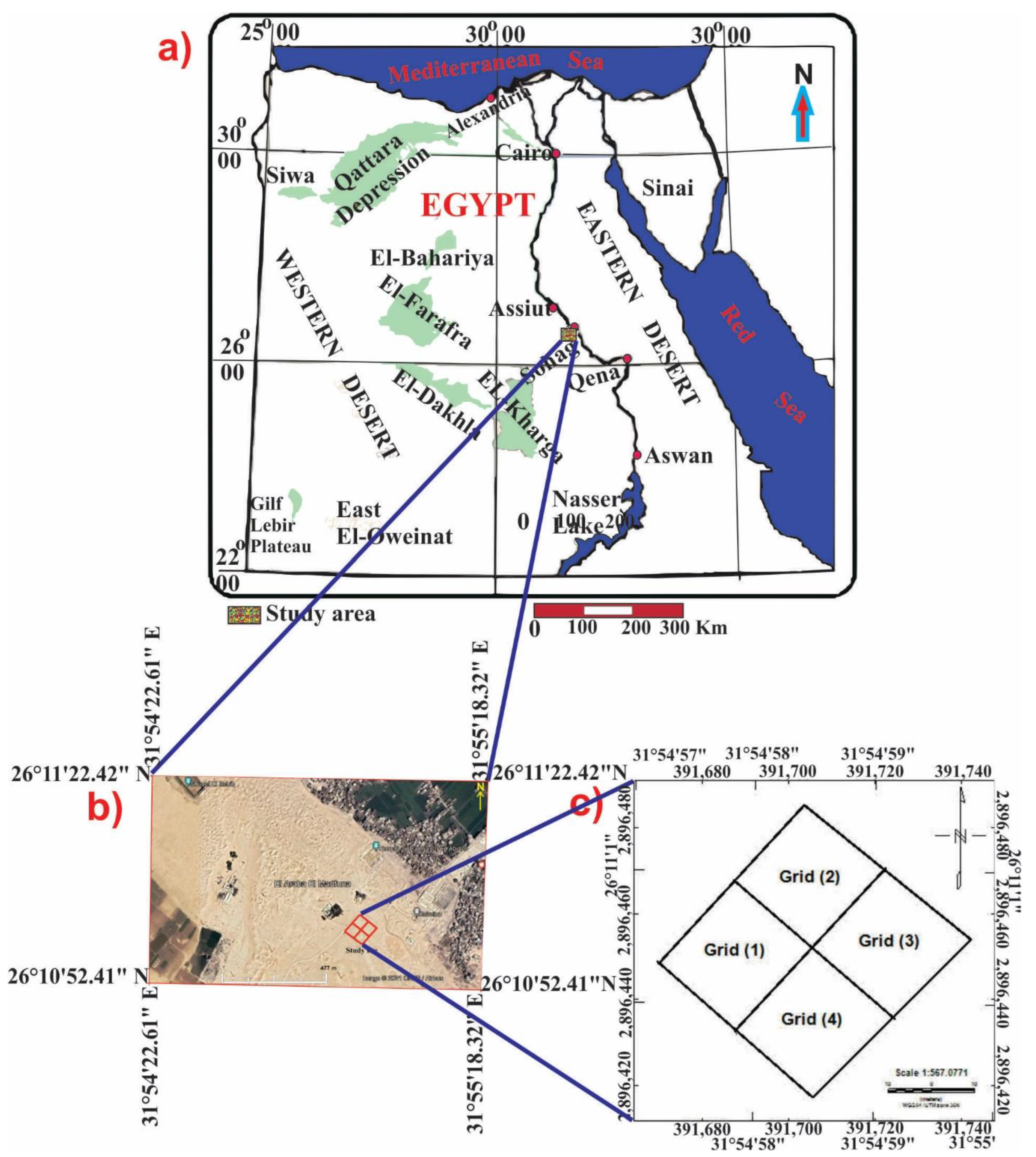
Figure 1. (a) Map of Egypt indicating the location of the study region in Sohag Governorate; (b) Google Earth photograph of the Abydos site indicating the study area; and (c) Map displaying the details of the surveyed grids for both ground magnetic survey and GPR application on the investigated site.
Applsci 12 09640 g001
Figure 2. Simplified geological map of Sohag Governorate [62].
Applsci 12 09640 g002
Figure 3. The stratigraphic sequence west of Abydos area [62]. In this figure, the geologic formations of the study region are arranged chronologically.
Applsci 12 09640 g003
Figure 4. (a) is GPR field survey operation, and (b) is GSSI-SIR 4000 instrument attached with a central frequency antenna of 200 MHZ.
Applsci 12 09640 g004
Figure 5. Locations of the GPR profiles in the study region, where the main site was categorized into four grids for implementation of the radar field survey. Every grid was surveyed with 35 parallel profiles with a length of 50 m conducing 140 profiles for the total work.
Applsci 12 09640 g005
Figure 6. Shaded color relief maps of: (a) the total magnetic intensity (TMI), (b) the high-pass filter, (c) the first vertical derivative (FVD) filter, (d) the analytical signal (AS) filter, and (e) the source parameter imaging (SPI) technique. The magnetic anomalies that may be archaeological objects are shown by the black circles (1–8), which were validated using the GPR technique.
Applsci 12 09640 g006
Figure 7. Radargram sections of three successive lines (L63, L64 and L65) executed on grid No. (3) during reconnaissance survey in Abydos site. Their lengths are 50 m. These sections show presence of the same anomalous feature indicated by the hyperbolic shape mentioned in the blue circle with considerable dimension and amplitude which may indicate an archeological remain (chamber or tomb).
Applsci 12 09640 g007
Figure 8. Radargram sections of three successive inline profiles (L27, L28 and L29) executed on grid No. (3) during detailed survey in Abydos site. Their lengths are 15 m. These sections show the same hyperbolic shape indicated in the reconnaissance profiles with the same dimension, amplitude and depth. It was shown in the blue circle.
Applsci 12 09640 g008
Figure 9. Radargram sections of three successive crossline profiles (L37, L38 and L39) executed on grid No. (3) during detailed survey in Abydos site. Their lengths are 15 m. These sections show the same hyperbolic shape indicated in the reconnaissance profiles with the same dimension, amplitude and depth. It was shown in the blue circle.
Applsci 12 09640 g009
Figure 10. A correlation between magnetic and GPR findings for the same profile. The apex of the anomaly is located between 20 to 30 m from the beginning of the magnetic and GPR 2D cross section with the same width. The blue circle displays the anomalous feature, which is indicated by the hyperbolic shape and might be an ancient artefact.
Applsci 12 09640 g010
Figure 11. Locations of the potential archaeological targets, inferred from magnetic and GPR results. They were represented by red circles.
Applsci 12 09640 g011
Publisher’s Note: MDPI stays neutral with regard to jurisdictional claims in published maps and institutional affiliations.