
Using Persistent Scatterer Interferometry for Post-Earthquake Landslide Susceptibility Mapping in Jiuzhaigou

 ,
,  ,
,
Abstract
:1. Introduction
2. Materials and Methods
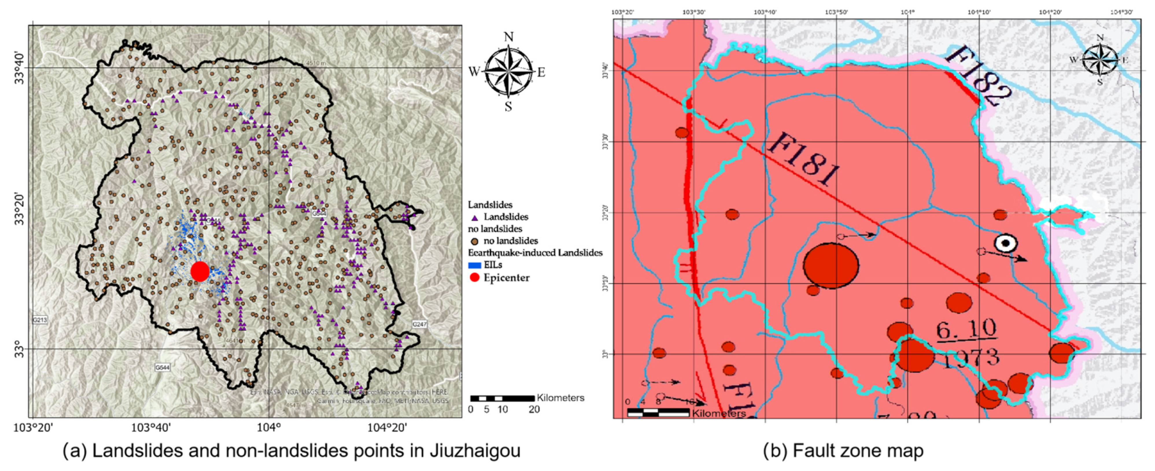
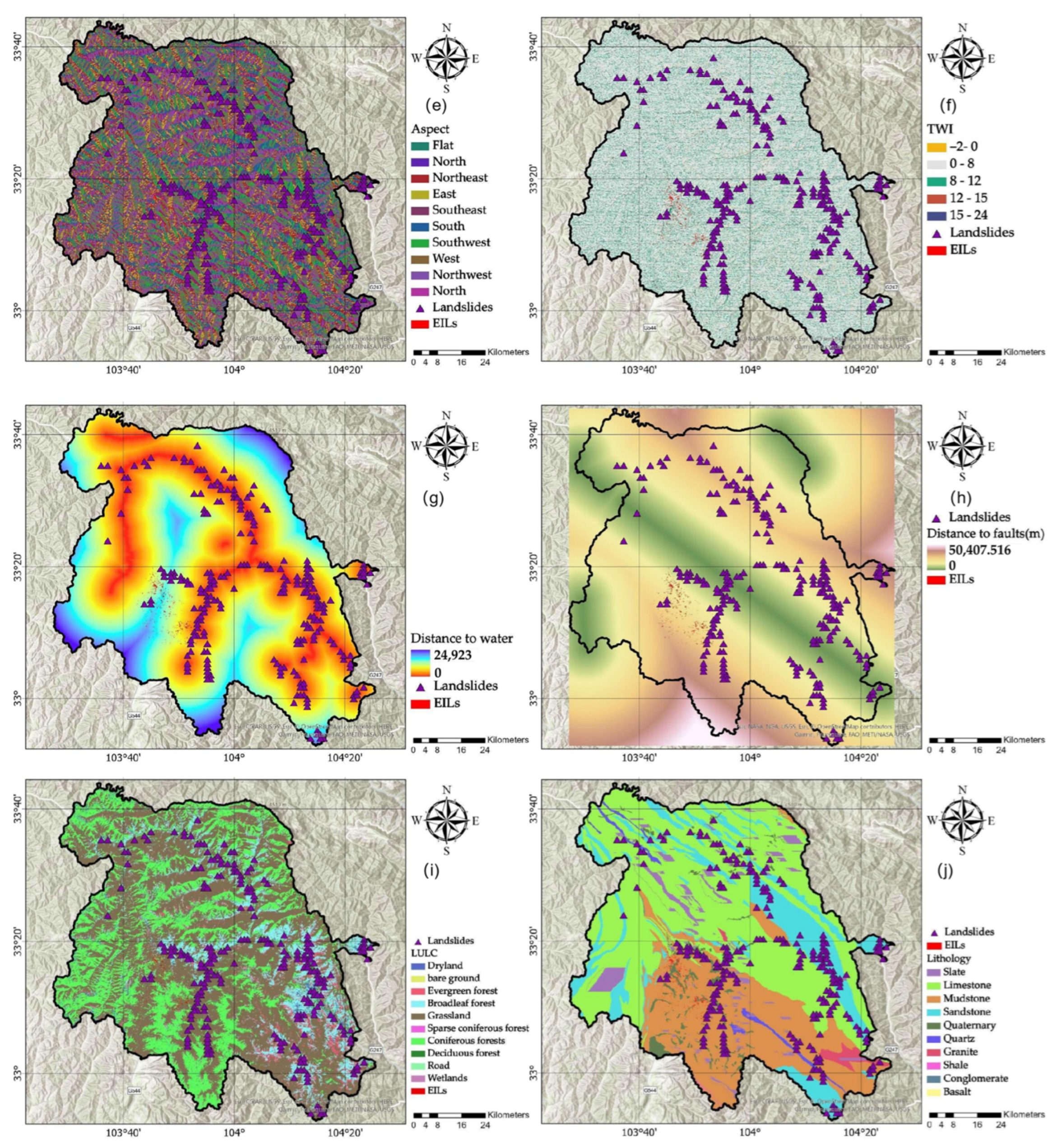
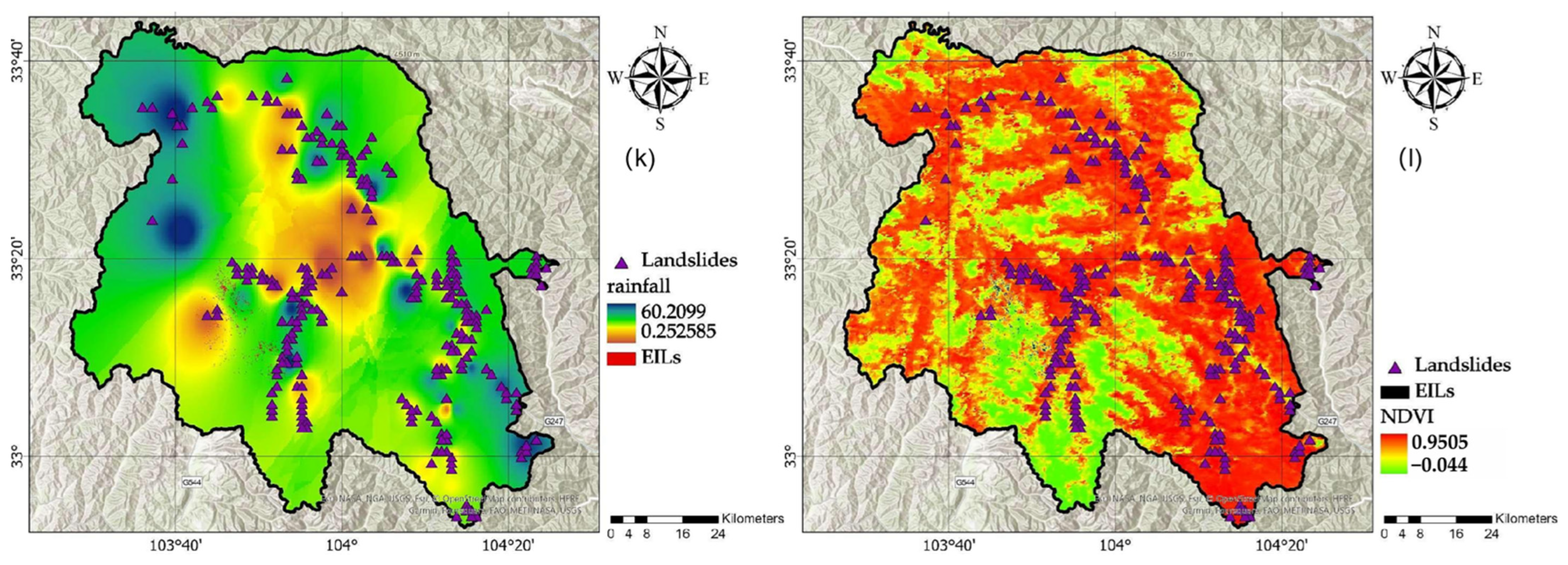
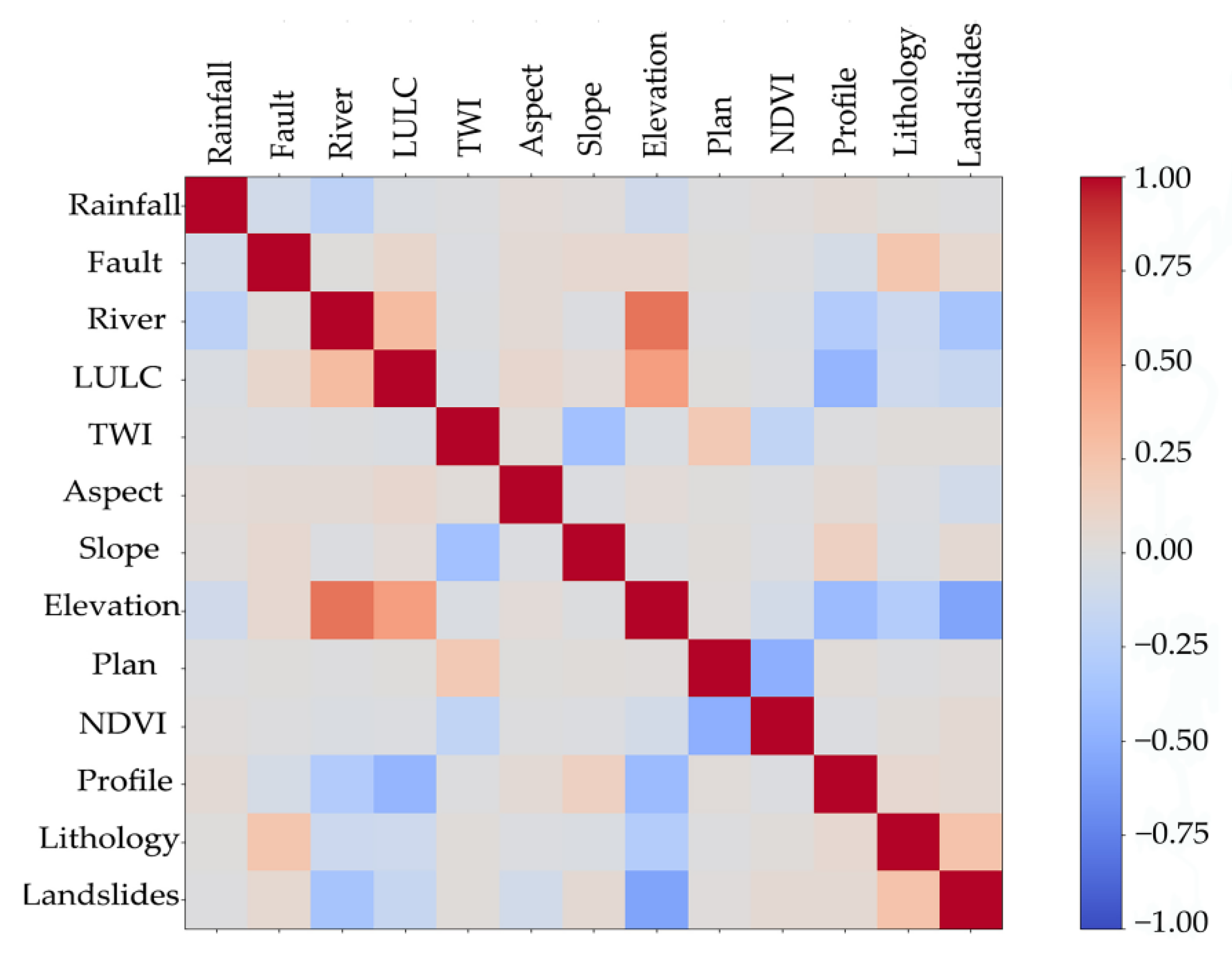
2.1. Study Area and Landslide Impact Factors
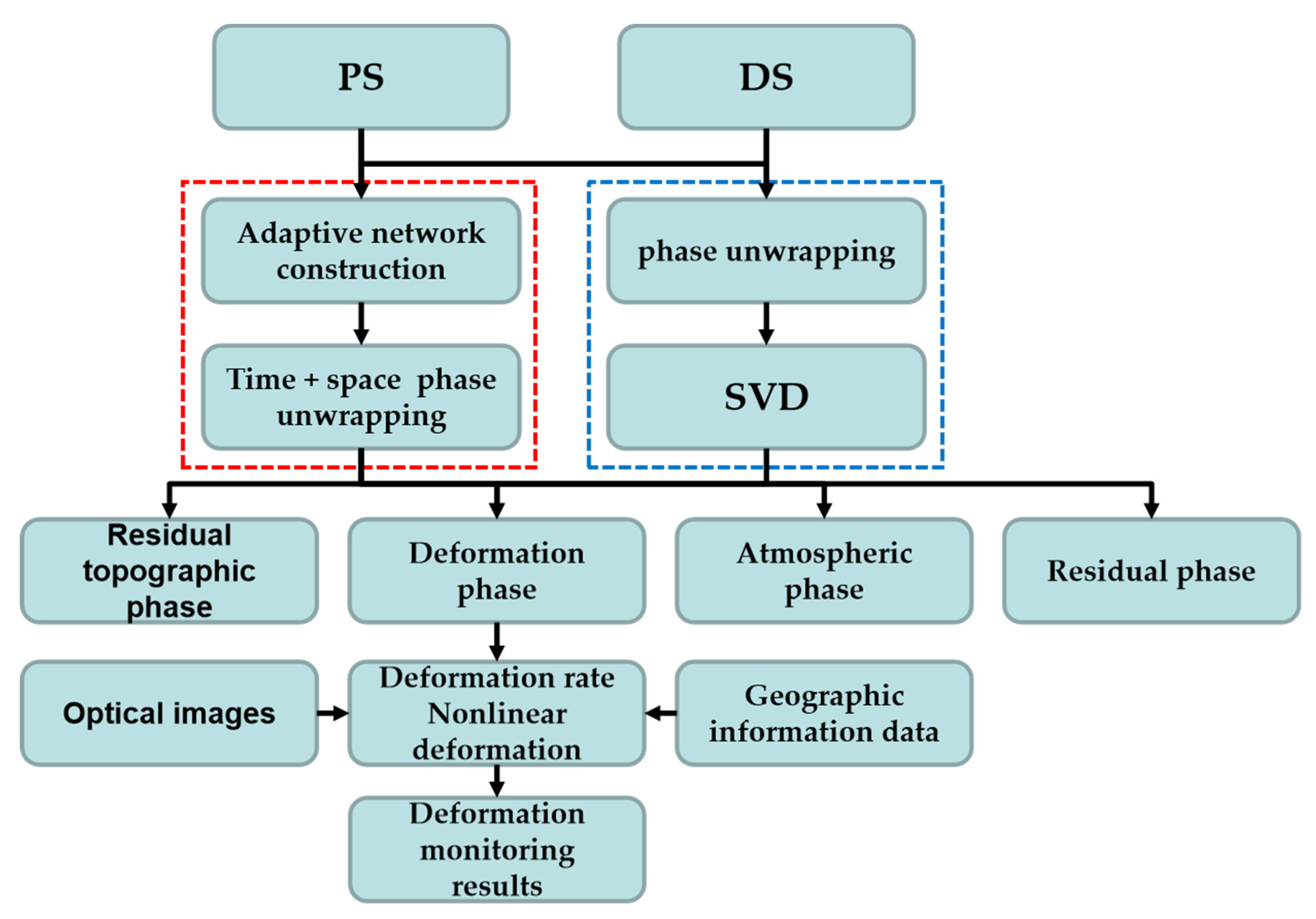
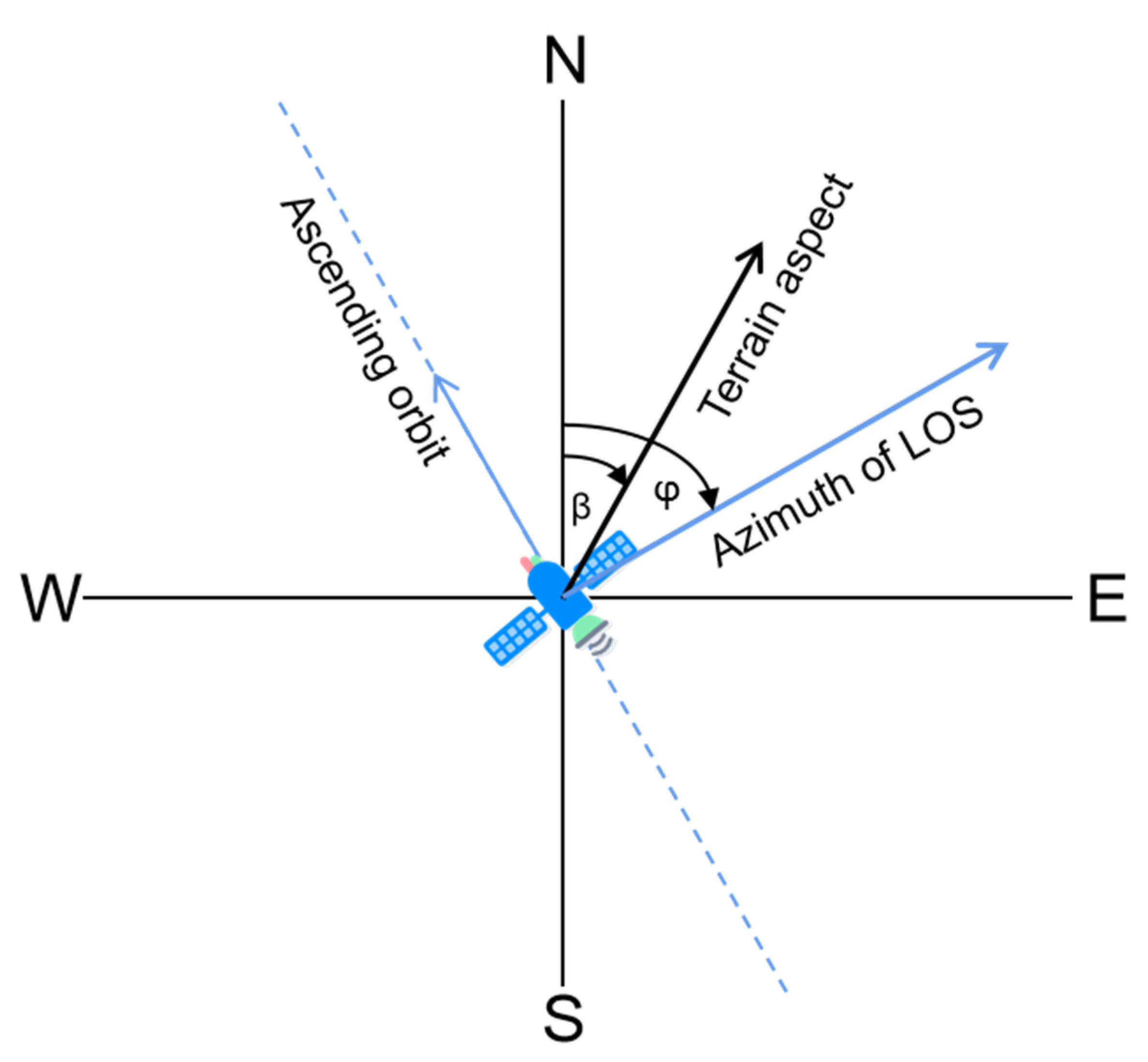
2.2. Multi-Temporal InSAR Method
2.3. Landslide Susceptibility Algorithms
2.4. Integration
3. Result
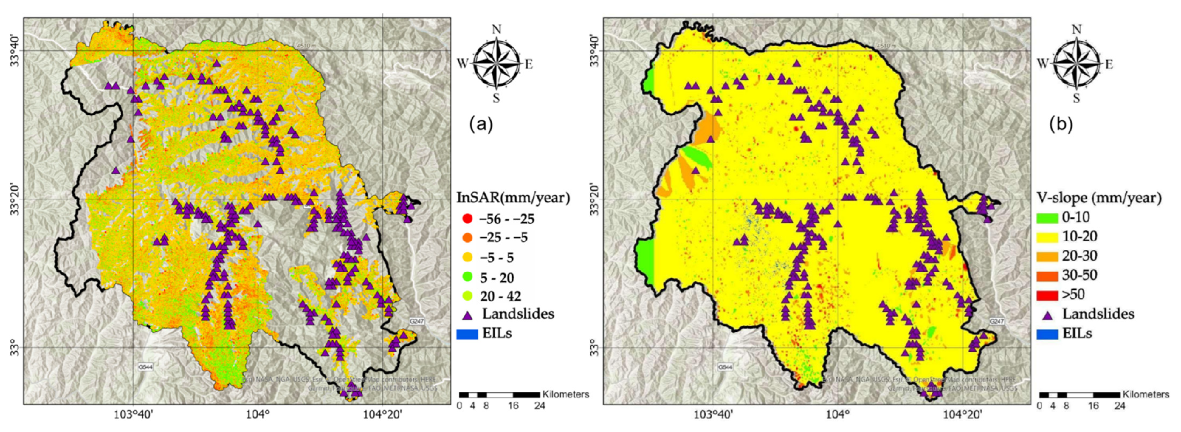
3.1. PS and DS InSAR
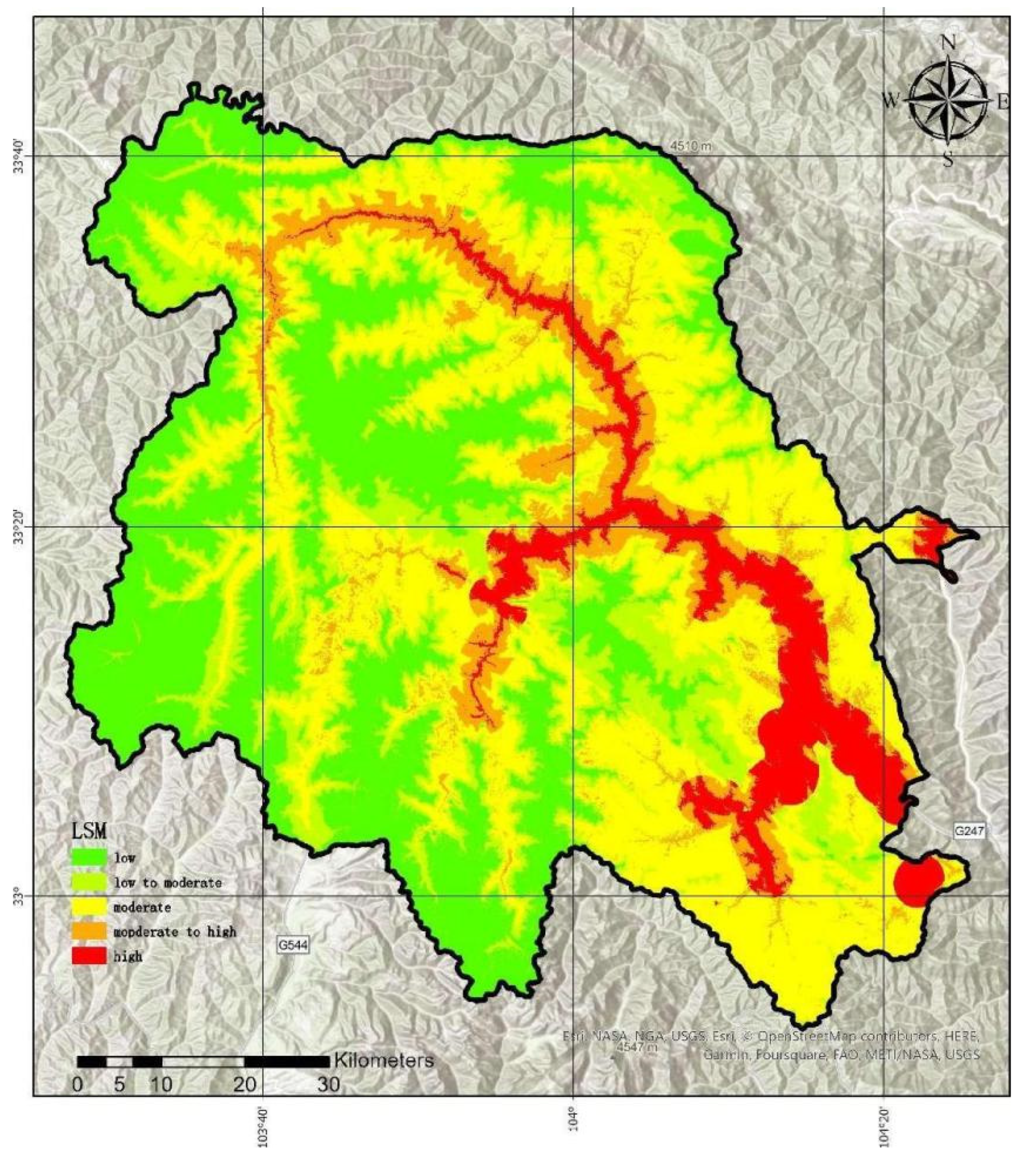
3.2. The Preliminary LSM
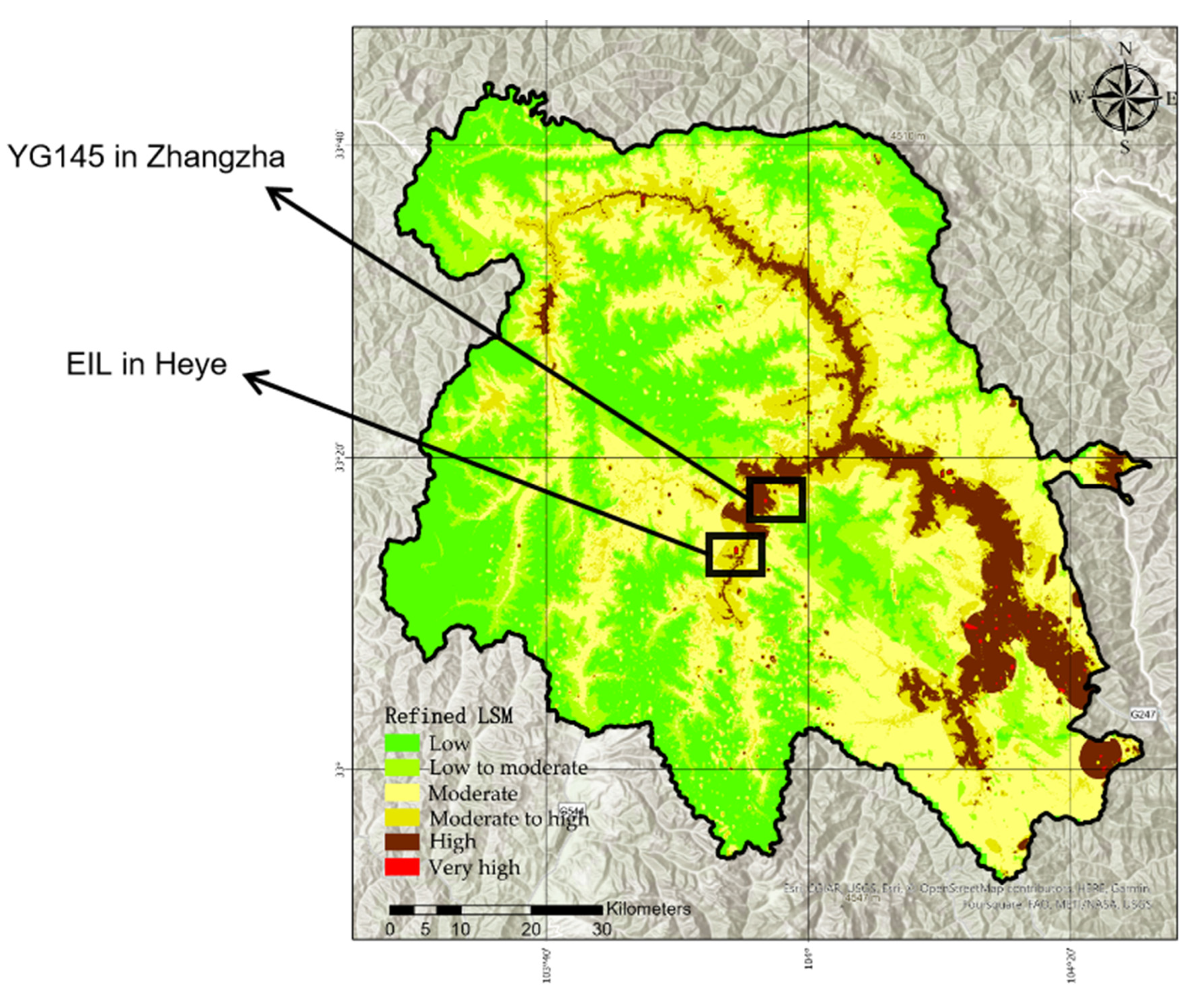
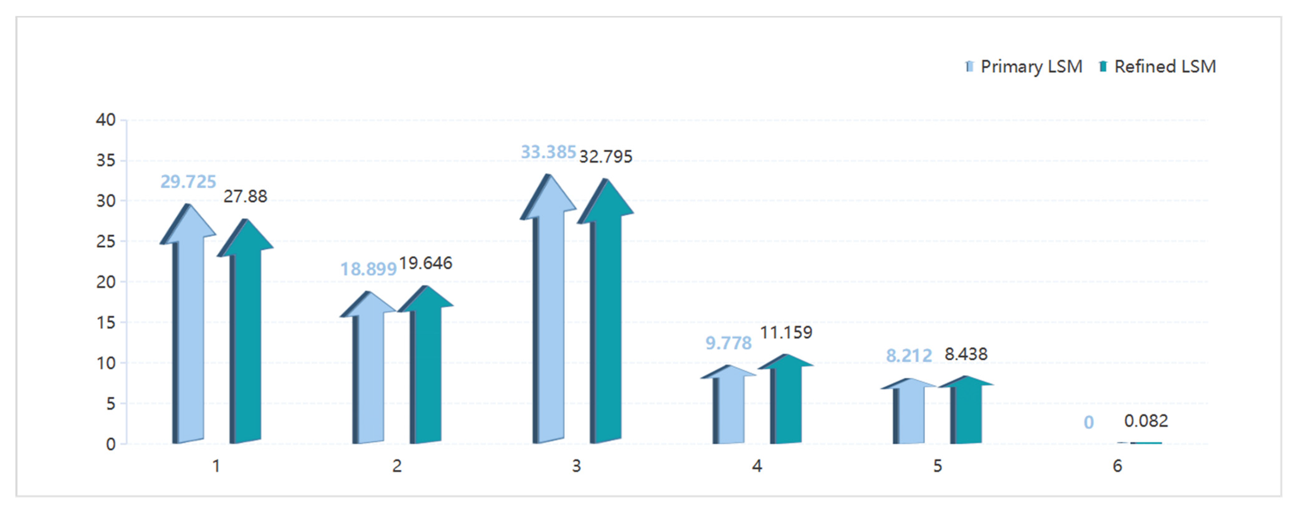
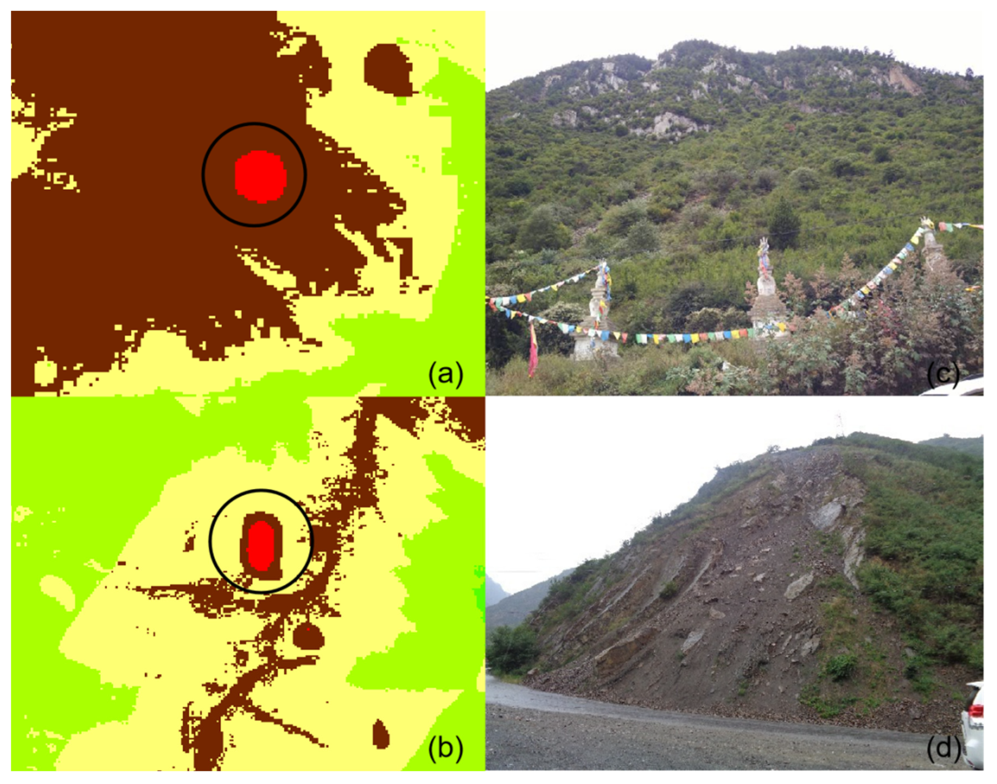
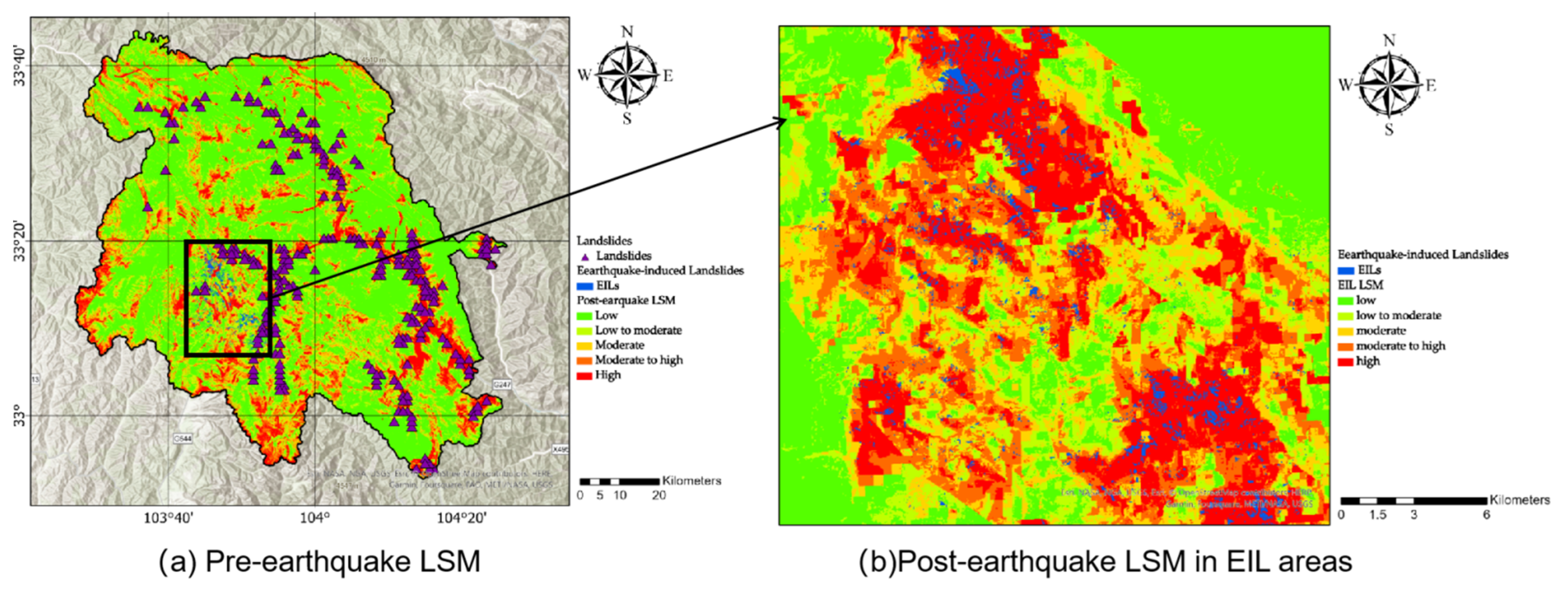
3.3. Refined Earthquake-Induced LSM of the Jiuzhaigou Region
4. Discussion
5. Conclusions
Author Contributions
Funding
Institutional Review Board Statement
Informed Consent Statement
Data Availability Statement
Acknowledgments
Conflicts of Interest
References
- Lee, C.T.; Huang, C.C.; Lee, J.F.; Pan, K.L.; Lin, M.L.; Dong, J.J. Statistical approach to earthquake-induced landslide susceptibility. Eng. Geol. 2008, 100, 43–58. [Google Scholar] [CrossRef]
- Tanyaş, H.; Van Westen, C.J.; Allstadt, K.E.; Anna Nowicki Jessee, M.; Görüm, T.; Jibson, R.W.; Godt, J.W.; Sato, H.P.; Schmitt, R.G.; Marc, O.; et al. Presentation and analysis of a worldwide database of earthquake-induced landslide inventories. J. Geophys. Res. Earth Surf. 2017, 122, 1991–2015. [Google Scholar] [CrossRef]
- Zhao, B.; Wang, Y.S.; Luo, Y.H.; Li, J.; Zhang, X.; Shen, T. Landslides and dam damage resulting from the Jiuzhaigou earthquake (8 August 2017), Sichuan, China. R. Soc. Open Sci. 2018, 5, 171418. [Google Scholar] [CrossRef] [PubMed]
- Fan, X.; Scaringi, G.; Xu, Q.; Zhan, W.; Dai, L.; Li, Y.; Pei, X.; Yang, Q.; Huang, R. Coseismic landslides triggered by the 8th August 2017 Ms 7.0 Jiuzhaigou earthquake (Sichuan, China): Factors controlling their spatial distribution and implications for the seismogenic blind fault identification. Landslides 2018, 15, 967–983. [Google Scholar] [CrossRef]
- Hu, X.; Hu, K.; Zhang, X.; Wei, L.; Tang, J.-B. Quantitative assessment of the impact of earthquake-induced geohazards on natural landscapes in Jiuzhaigou Valley. J. Mt. Sci. 2019, 16, 441–452. [Google Scholar] [CrossRef]
- Xu, C.; Xu, X.; Zhou, B.; Shen, L. Probability of coseismic landslides: A new generation of earthquake-triggered landslide hazard model. J. Eng. Geol. 2019, 27, 1122–1130. [Google Scholar] [CrossRef]
- Cai, J.; Zhang, L.; Dong, J.; Dong, X.; Liao, M.; Xu, Q. Detection and Monitoring of Post-Earthquake Landslides in Jiuzhaigou Using Radar Remote Sensing. Geomat. Inf. Sci. Wuhan Univ. 2020, 45, 1707–1716. [Google Scholar] [CrossRef]
- Huang, Y.; Zhao, L. Review on landslide susceptibility mapping using support vector machines. Catena 2018, 165, 520–529. [Google Scholar] [CrossRef]
- Dahal, R.K.; Hasegawa, S.; Nonomura, A.; Yamanaka, M.; Masuda, T.; Nishino, K. GIS-based weights-of-evidence modelling of rainfall-induced landslides in small catchments for landslide susceptibility mapping. Environ. Geol. 2008, 54, 311–324. [Google Scholar] [CrossRef]
- Achour, Y.; Pourghasemi, H.R. How do machine learning techniques help in increasing accuracy of landslide susceptibility maps? Geosci. Front. 2020, 11, 871–883. [Google Scholar] [CrossRef]
- Chen, X.; Chen, W. GIS-based landslide susceptibility assessment using optimized hybrid machine learning methods. Catena 2021, 196, 104833. [Google Scholar] [CrossRef]
- Nguyen, V.T.; Tran, T.H.; Ha, N.A.; Ngo, V.L.; Nadhir, A.A.; Tran, V.P.; Duy Nguyen, H.; Malek, M.A.; Amini, A.; Prakash, I.; et al. GIS based novel hybrid computational intelligence models for mapping landslide susceptibility: A case study at da lat city, Vietnam. Sustainability 2019, 11, 7118. [Google Scholar] [CrossRef]
- Oshan, T.M.; Li, Z.; Kang, W.; Wolf, L.J.; Fotheringham, A.S. mgwr: A Python implementation of multiscale geographically weighted regression for investigating process spatial heterogeneity and scale. ISPRS Int. J. Geo-Inf. 2019, 8, 269. [Google Scholar] [CrossRef]
- Lombardo, L.; Tanyas, H. Chrono-validation of near-real-time landslide susceptibility models via plug-in statistical simulations. Eng. Geol. 2020, 278, 105818. [Google Scholar] [CrossRef]
- Ozturk, U. Geohazards explained 10: Time-dependent landslide susceptibility. Geol. Today 2022, 38, 117–120. [Google Scholar] [CrossRef]
- Wang, H.J.; Xiao, T.; Li, X.Y.; Zhang, L.L.; Zhang, L.M. A novel physically-based model for updating landslide susceptibility. Eng. Geol. 2019, 251, 71–80. [Google Scholar] [CrossRef]
- Luo, J.; Zhang, L.; Yang, H.; Wei, X.; Liu, D.; Xu, J. Probabilistic model calibration of spatial variability for a physically-based landslide susceptibility model. Georisk Assess. Manag. Risk Eng. Syst. Geohazards 2021, 1–18. [Google Scholar] [CrossRef]
- Hu, S.; Wang, X.; Wang, N.; Yang, D.; Wang, D.; Ma, S.; Song, Z.; Cao, M. Dynamic process, influence, and triggering mechanism of slope remodelling by landslide clusters in the South Jingyang Tableland, China. CATENA 2022, 217, 106518. [Google Scholar] [CrossRef]
- Luti, T.; Segoni, S.; Catani, F.; Munafò, M.; Casagli, N. Integration of remotely sensed soil sealing data in landslide susceptibility mapping. Remote Sens. 2020, 12, 1486. [Google Scholar] [CrossRef]
- Bachri, S.; Shrestha, R.P.; Yulianto, F.; Sumarmi, S.; Utomo, K.S.B.; Aldianto, Y.E. Mapping landform and landslide susceptibility using remote sensing, gis and field observation in the southern cross road, Malang regency, East Java, Indonesia. Geosciences 2020, 11, 4. [Google Scholar] [CrossRef]
- Strozzi, T.; Farina, P.; Corsini, A.; Ambrosi, C.; Thüring, M.; Zilger, J.; Wiesmann, A.; Wegmüller, U.; Werner, C. Survey and monitoring of landslide displacements by means of L-band satellite SAR interferometry. Landslides 2005, 2, 193–201. [Google Scholar] [CrossRef]
- Strozzi, T.; Klimeš, J.; Frey, H.; Caduff, R.; Huggel, C.; Wegmüller, U.; Rapre, A.C. Satellite SAR interferometry for the improved assessment of the state of activity of landslides: A case study from the Cordilleras of Peru. Remote Sens. Environ. 2018, 217, 111–125. [Google Scholar] [CrossRef]
- Greif, V.; Vlcko, J. Monitoring of post-failure landslide deformation by the PS-InSAR technique at Lubietova in Central Slovakia. Environ. Earth Sci. 2012, 66, 1585–1595. [Google Scholar] [CrossRef]
- Dong, J.; Zhang, L.; Li, M.; Yu, Y.; Liao, M.; Gong, J.; Luo, H. Measuring precursory movements of the recent Xinmo landslide in Mao County, China with Sentinel-1 and ALOS-2 PALSAR-2 datasets. Landslides 2018, 15, 135–144. [Google Scholar] [CrossRef]
- Bayer, B.; Schmidt, D.; Simoni, A. The Influence of External Digital Elevation Models on PS-InSAR and SBAS Results: Implications for the Analysis of Deformation Signals Caused by Slow Moving Landslides in the Northern Apennines (Italy). IEEE Trans. Geosci. Remote Sens. 2017, 55, 2618–2631. [Google Scholar] [CrossRef]
- Fadhillah, M.F.; Achmad, A.R.; Lee, C.-W. Improved Combined Scatterers Interferometry With Optimized Point Scatterers (ICOPS) for Interferometric Synthetic Aperture Radar (InSAR) Time-Series Analysis. IEEE Trans. Geosci. Remote Sens. 2022, 60, 5220014. [Google Scholar] [CrossRef]
- Oliveira, S.C.; Zêzere, J.L.; Catalão, J.; Nico, G. The contribution of PSInSAR interferometry to landslide hazard in weak rock-dominated areas. Landslides 2015, 12, 703–719. [Google Scholar] [CrossRef]
- Hussain, M.A.; Chen, Z.; Wang, R.; Shoaib, M. PS-InSAR-based validated landslide susceptibility mapping along Karakorum Highway, Pakistan. Remote Sens. 2021, 13, 4129. [Google Scholar] [CrossRef]
- Ciampalini, A.; Raspini, F.; Lagomarsino, D.; Catani, F.; Casagli, N. Landslide susceptibility map refinement using PSInSAR data. Remote Sens. Environ. 2016, 184, 302–315. [Google Scholar] [CrossRef]
- Yi, Y.; Zhang, Z.; Zhang, W.; Jia, H.; Zhang, J. Landslide susceptibility mapping using multiscale sampling strategy and convolutional neural network: A case study in Jiuzhaigou region. Catena 2020, 195, 104851. [Google Scholar] [CrossRef]
- Cao, Y.; Wang, B.; Zhang, J.; Wang, L.; Pan, Y.; Wang, Q.; Jian, D.; Deng, G. Lake macroinvertebrate assemblages and relationship with natural environment and tourism stress in Jiuzhaigou Natural Reserve, China. Ecol. Indic. 2016, 62, 182–190. [Google Scholar] [CrossRef]
- Jain, S. Karst. In Fundamentals of Physical Geology. Springer Geology; Springer: New Delhi, India, 2014. [Google Scholar] [CrossRef]
- Qiao, X.; Du, J.; Lugli, S.; Ren, J.; Xiao, W.; Chen, P.; Tang, Y. Are climate warming and enhanced atmospheric deposition of sulfur and nitrogen threatening tufa landscapes in Jiuzhaigou National Nature Reserve, Sichuan, China? Sci. Total Environ. 2016, 562, 724–731. [Google Scholar] [CrossRef] [PubMed]
- Liu, L. Factors Affecting Tufa Degradation in Jiuzhaigou National Nature Reserve, Sichuan, China. Water 2017, 9, 702. [Google Scholar] [CrossRef]
- Hu, X.; Hu, K.; Tang, J.; You, Y.; Wu, C. Assessment of debris-flow potential dangers in the Jiuzhaigou Valley following the August 8, 2017, Jiuzhaigou earthquake, western China. Eng. Geol. 2019, 256, 57–66. [Google Scholar] [CrossRef]
- Gao, S.D. Overview of tracking of Sichuan Jiuzhaigou MS 7.0 earthquake in 2017 and its post earthquake precursor anomaly summary. Prog. Geophys. 2020, 35, 1250–1260. [Google Scholar] [CrossRef]
- Modava, M.; Akbarizadeh, G.; Soroosh, M. Hierarchical coastline detection in SAR images based on spectral-textural features and global–local information. IET Radar Sonar Navig. 2019, 13, 2183–2195. [Google Scholar] [CrossRef]
- Dubovik, O.; Fuertes, D.; Litvinov, P.; Lopatin, A.; Lapyonok, T.; Doubovik, I.; Xu, F.; Ducos, F.; Chen, C.; Torres, B.; et al. A comprehensive description of multi-term LSM for applying multiple a priori constraints in problems of atmospheric remote sensing: GRASP algorithm, concept, and applications. Front. Remote Sens. 2021, 2, 706851. [Google Scholar] [CrossRef]
- Roy, J.; Saha, S.; Arabameri, A.; Blaschke, T.; Bui, D.T. A novel ensemble approach for landslide susceptibility mapping (LSM) in Darjeeling and Kalimpong districts, West Bengal, India. Remote Sens. 2019, 11, 2866. [Google Scholar] [CrossRef]
- Chen, Y.; Ming, D.; Ling, X.; Lv, X.; Zhou, C. Landslide Susceptibility Mapping Using Feature Fusion-Based CPCNN-ML in Lantau Island, Hong Kong. IEEE J. Sel. Top. Appl. Earth Obs. Remote Sens. 2021, 14, 3625–3639. [Google Scholar] [CrossRef]
- Rasyid, A.R.; Bhandary, N.P.; Yatabe, R. Performance of frequency ratio and logistic regression model in creating GIS based landslides susceptibility map at Lompobattang Mountain, Indonesia. Geoenviron. Disasters 2016, 3, 19. [Google Scholar] [CrossRef]
- Feizizadeh, B.; Roodposhti, M.S.; Blaschke, T.; Aryal, J. Comparing GIS-based support vector machine kernel functions for landslide susceptibility mapping. Arab. J. Geosci. 2017, 10, 122. [Google Scholar] [CrossRef]
- Xu, C. Distribution of landslide data from the Ms7.0 earthquake in Jiuzhaigou County, Sichuan Province on 8 August 2017. National Cryosphere Desert Data Center. 2022. Available online: http://www.ncdc.ac.cn/portal/metadata/4716fd91-2fd4-4e30-a9a1-7931a0d0b1b2 (accessed on 24 April 2022).
- Shan, W.; Jin, X.; Ren, J.; Wang, Y.; Xu, Z.; Fan, Y.; Gu, Z.; Hong, C.; Lin, J.; Zhou, Y. Ecological environment quality assessment based on remote sensing data for land consolidation. J. Clean. Prod. 2019, 239, 118126. [Google Scholar] [CrossRef]
- Pawluszek, K.; Borkowski, A. Impact of DEM-derived factors and analytical hierarchy process on landslide susceptibility mapping in the region of Rożnów Lake, Poland. Nat. Hazards 2017, 86, 919–952. [Google Scholar] [CrossRef]
- Persichillo, M.G.; Bordoni, M.; Meisina, C. The role of land use changes in the distribution of shallow landslides. Sci. Total Environ. 2017, 574, 924–937. [Google Scholar] [CrossRef] [PubMed]
- Irigaray, C.; Lamas, F.; El Hamdouni, R.; Fernández, T.; Chacón, J. The Importance of the Precipitation and the Susceptibility of the Slopes for the Triggering of Landslides Along the Roads. Nat. Hazards 2000, 21, 65–81. [Google Scholar] [CrossRef]
- Abraham, M.T.; Satyam, N.; Pradhan, B.; Alamri, A.M. Forecasting of landslides using rainfall severity and soil wetness: A probabilistic approach for Darjeeling Himalayas. Water 2020, 12, 804. [Google Scholar] [CrossRef]
- Ohlmacher, G.C. Plan curvature and landslide probability in regions dominated by earth flows and earth slides. Eng. Geol. 2007, 91, 117–134. [Google Scholar] [CrossRef]
- Wubalem, A.; Meten, M. Landslide susceptibility mapping using information value and logistic regression models in Goncha Siso Eneses area, northwestern Ethiopia. SN Appl. Sci. 2020, 2, 807. [Google Scholar] [CrossRef]
- Necula, N.; Niculiță, M.; Fiaschi, S.; Genevois, R.; Riccardi, P.; Floris, M. Assessing Urban Landslide Dynamics through Multi-Temporal InSAR Techniques and Slope Numerical Modeling. Remote Sens. 2021, 13, 3862. [Google Scholar] [CrossRef]
- Shi, X.; Yang, C.; Zhang, L.; Jiang, H.; Liao, M.; Zhang, L.; Liu, X. Mapping and characterizing displacements of active loess slopes along the upstream Yellow River with multi-temporal InSAR datasets. Sci. Total Environ. 2019, 674, 200–210. [Google Scholar] [CrossRef]
- Han, Y.; Zou, J.; Lu, Z.; Qu, F.; Kang, Y.; Li, J. Ground deformation of wuhan, china, revealed by multi-temporal insar analysis. Remote Sens. 2020, 12, 3788. [Google Scholar] [CrossRef]
- Zhou, C.; Cao, Y.; Yin, K.; Wang, Y.; Shi, X.; Catani, F.; Ahmed, B. Landslide characterization applying sentinel-1 images and InSAR technique: The muyubao landslide in the three Gorges Reservoir Area, China. Remote Sens. 2020, 12, 3385. [Google Scholar] [CrossRef]
- Ferretti, A.; Savio, G.; Barzaghi, R.; Borghi, A.; Musazzi, S.; Novali, F.; Prati, C.; Rocca, F. Submillimeter accuracy of InSAR time series: Experimental validation. IEEE Trans. Geosci. Remote Sens. 2007, 45, 1142–1153. [Google Scholar] [CrossRef]
- Ferretti, A.; Fumagalli, A.; Novali, F.; Prati, C.; Rocca, F.; Rucci, A. A new algorithm for processing interferometric data-stacks: SqueeSAR. IEEE Trans. Geosci. Remote Sens. 2011, 49, 3460–3470. [Google Scholar] [CrossRef]
- Wang, J.; Wang, C.; Tang, Y.; Zhang, H.; Duan, W.; Dong, L. Investigation for the Surface Deformation of Tanggula Mountain Permafrost Using Distributed Scatterer INSAR. In Proceedings of the 2021 IEEE International Geoscience and Remote Sensing Symposium IGARSS, Brussels, Belgium, 11–16 July 2021; pp. 5358–5361. [Google Scholar] [CrossRef]
- Liu, Y.; Yang, H.; Wang, S.; Xu, L.; Peng, J. Monitoring and Stability Analysis of the Deformation in the Woda Landslide Area in Tibet, China by the DS-InSAR Method. Remote Sens. 2022, 14, 532. [Google Scholar] [CrossRef]
- Meng, Q.; Li, W.; Raspini, F.; Xu, Q.; Peng, Y.; Ju, Y.; Zheng, Y.; Casagli, N. Time-series analysis of the evolution of large-scale loess landslides using InSAR and UAV photogrammetry techniques: A case study in Hongheyan, Gansu Province, Northwest China. Landslides 2021, 18, 251–265. [Google Scholar] [CrossRef]
- Even, M.; Schulz, K. InSAR deformation analysis with distributed scatterers: A review complemented by new advances. Remote Sens. 2018, 10, 744. [Google Scholar] [CrossRef]
- Wang, G.; Xu, B.; Li, Z.; Fu, H.; Gao, H.; Wan, J.; Wang, C. A Phase Optimization Method for DS-InSAR Based on SKP Decomposition From Quad-Polarized Data. IEEE Geosci. Remote Sens. Lett. 2022, 19, 4008805. [Google Scholar] [CrossRef]
- Bianchini, S.; Solari, L.; Del Soldato, M.; Raspini, F.; Montalti, R.; Ciampalini, A.; Casagli, N. Ground subsidence susceptibility (GSS) mapping in Grosseto Plain (Tuscany, Italy) based on satellite InSAR data using frequency ratio and fuzzy logic. Remote Sens. 2019, 11, 2015. [Google Scholar] [CrossRef]
- Notti, D.; Herrera, G.; Bianchini, S.; Meisina, C.; García-Davalillo, J.C.; Zucca, F. A methodology for improving landslide PSI data analysis. Int. J. Remote Sens. 2014, 35, 2186–2214. [Google Scholar] [CrossRef]
- Chen, W.; Zhang, S.; Li, R.; Shahabi, H. Performance evaluation of the GIS-based data mining techniques of best-first decision tree, random forest, and naïve Bayes tree for landslide susceptibility modeling. Sci. Total Environ. 2018, 644, 1006–1018. [Google Scholar] [CrossRef] [PubMed]
- Lee, S.; Chwae, U.; Min, K. Landslide susceptibility mapping by correlation between topography and geological structure: The Janghung area, Korea. Geomorphology 2002, 46, 149–162. [Google Scholar] [CrossRef]
- Ohlmacher, G.C.; Davis, J.C. Using multiple logistic regression and GIS technology to predict landslide hazard in northeast Kansas, USA. Eng. Geol. 2003, 69, 331–343. [Google Scholar] [CrossRef]
- Kalantar, B.; Pradhan, B.; Naghibi, S.A.; Motevalli, A.; Mansor, S. Assessment of the effects of training data selection on the landslide susceptibility mapping: A comparison between support vector machine (SVM), logistic regression (LR) and artificial neural networks (ANN). Geomat. Nat. Hazards Risk 2018, 9, 49–69. [Google Scholar] [CrossRef]
- Zhao, S.; Zhao, Z. A comparative study of landslide susceptibility mapping using SVM and PSO-SVM models based on Grid and Slope Units. Math. Probl. Eng. 2021, 2021, 8854606. [Google Scholar] [CrossRef]
- Liu, R.; Li, L.; Pirasteh, S.; Lai, Z.; Yang, X.; Shahabi, H. The performance quality of LR, SVM, and RF for earthquake-induced landslides susceptibility mapping incorporating remote sensing imagery. Arab. J. Geosci. 2021, 14, 259. [Google Scholar] [CrossRef]
- Mezaal, M.R.; Pradhan, B. An improved algorithm for identifying shallow and deep-seated landslides in dense tropical forest from airborne laser scanning data. Catena 2018, 167, 147–159. [Google Scholar] [CrossRef]
- Wang, W.; Liu, J.; Innes, J.L. Conservation equity for local communities in the process of tourism development in protected areas: A study of Jiuzhaigou Biosphere Reserve, China. World Dev. 2019, 124, 104637. [Google Scholar] [CrossRef]


| No. | Data | Resolution (m) | Source | Purpose |
|---|---|---|---|---|
| 1 | DEM | 30 | SRTM 30 m | Preparing factor maps |
| 2 | Remote sensing images | 30 | Landsat 8 Satellite | NDVI |
| 3 | Geological map | 30 | Sichuan Ecological and Environmental Restoration Institute | Lithology and faults |
| 4 | Pre-landslide inventory | - | Sichuan Ecological and Environmental Restoration Institute | Landslide inventory |
| 5 | Earthquake-induced landslides | National Cryosphere Desert Data Center | Landslide inventory | |
| 6 | SAR images | 10 m | European Space Agency (ESA) | InSAR and deformation |
| Class of Factors | Factors Selected | Scale | Data source |
|---|---|---|---|
| Topography | Elevation | 30 m | Calculated from DEM in Arcgis pro |
| Slope angle | 30 m | ||
| Aspect | 30 m | ||
| Topographic wetness index | 30 m | ||
| Profile curvature | 30 m | ||
| Plan curvature | 30 m | ||
| Geolithology | Distance to an active fault | 30 m | Sichuan Bureau of Surveying, Mappin-g and Geoinformation |
| Lithology | 30 m | ||
| Land use and Land cover | Land use and land cover | 30 m | Ministry of Natural Resources Data Center |
| Morphology | Distance to rivers | 30 m | Openstreetmap |
| Climate | Rainfall | Vector | Meteorological station monitoring data |
| Vegetation | NDVI | 30 m | Landsat |
| Landslide Causative Factors | Tolerance (TOL) | VIF |
|---|---|---|
| rainfall | 0.1674 | 5.9713 |
| fault | 0.3113 | 3.2119 |
| river | 0.2588 | 3.8630 |
| Land use and land cover | 0.1262 | 7.9232 |
| TWI | 0.1496 | 6.6815 |
| aspect | 0.2623 | 3.8120 |
| slope | 0.1987 | 5.0327 |
| DEM | 0.15977 | 6.2618 |
| plan | 0.1748 | 5.7187 |
| NDVI | 0.14191 | 7.0452 |
| profile | 0.2388 | 4.1872 |
| InSAR Deformation | ||||||
|---|---|---|---|---|---|---|
| LSM | 1 | 2 | 3 | 4 | 5 | |
| 1 | 1 | 1 | 1 | 2 | 3 | |
| 2 | 1 | 1 | 2 | 3 | 4 | |
| 3 | 1 | 2 | 3 | 4 | 5 | |
| 4 | 2 | 3 | 4 | 5 | 6 | |
| 5 | 3 | 4 | 5 | 6 | 6 | |
| Factor | Coefficients (LR) | Important Scores (RF) |
|---|---|---|
| rainfall | 0.1688 | 0.1135 |
| fault | 0.3229 | 0.1521 |
| river | −0.5832 | 0.2409 |
| LULC | 0.3881 | 0.0741 |
| TWI | 0.094 | 0.0531 |
| aspect | −0.077 | 0.0618 |
| slope | 0.0714 | 0.1208 |
| elevation | 0.0657 | 0.0784 |
| plan | 0.1284 | 0.0815 |
| NDVI | 0.1045 | 0.0766 |
| profile | 0.0203 | 0.0723 |
| lithology | −0.4818 | 0.1831 |
| a0 | 0.0152 | - |
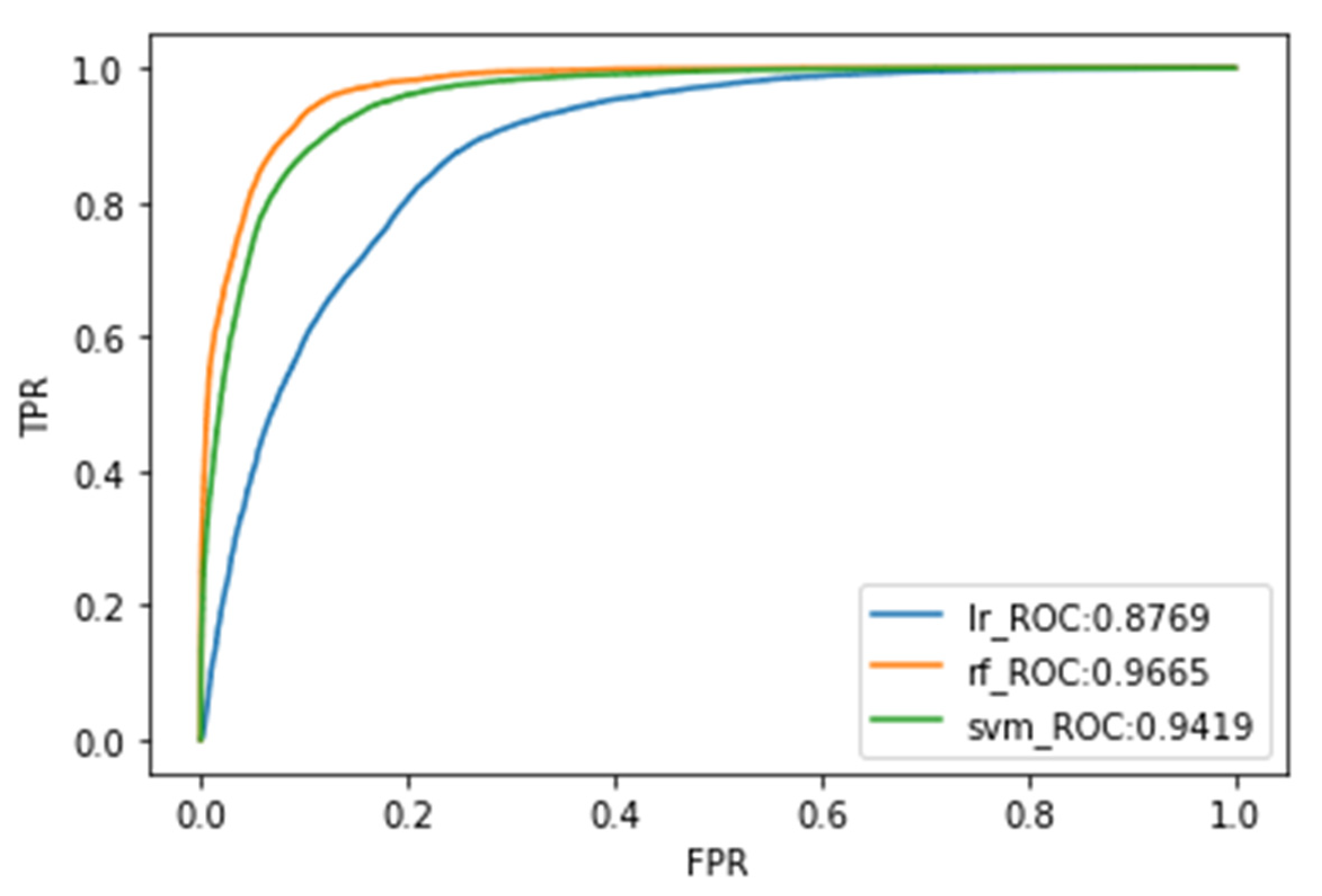
| Algorithm | Accuracy | Precision | F1 Score | Recall | AUC ROC |
|---|---|---|---|---|---|
| LR | 0.7951 | 0.7469 | 0.6953 | 0.7201 | 0.8769 |
| SVM | 0.8724 | 0.8175 | 0.8543 | 0.8355 | 0.9419 |
| RF | 0.9018 | 0.8259 | 0.9375 | 0.8772 | 0.9665 |
Publisher’s Note: MDPI stays neutral with regard to jurisdictional claims in published maps and institutional affiliations. |
© 2022 by the authors. Licensee MDPI, Basel, Switzerland. This article is an open access article distributed under the terms and conditions of the Creative Commons Attribution (CC BY) license (https://creativecommons.org/licenses/by/4.0/).
Share and Cite
Fang, H.; Shao, Y.; Xie, C.; Tian, B.; Zhu, Y.; Guo, Y.; Yang, Q.; Yang, Y. Using Persistent Scatterer Interferometry for Post-Earthquake Landslide Susceptibility Mapping in Jiuzhaigou. Appl. Sci. 2022, 12, 9228. https://doi.org/10.3390/app12189228
Fang H, Shao Y, Xie C, Tian B, Zhu Y, Guo Y, Yang Q, Yang Y. Using Persistent Scatterer Interferometry for Post-Earthquake Landslide Susceptibility Mapping in Jiuzhaigou. Applied Sciences. 2022; 12(18):9228. https://doi.org/10.3390/app12189228
Chicago/Turabian StyleFang, Haoran, Yun Shao, Chou Xie, Bangsen Tian, Yu Zhu, Yihong Guo, Qing Yang, and Ying Yang. 2022. "Using Persistent Scatterer Interferometry for Post-Earthquake Landslide Susceptibility Mapping in Jiuzhaigou" Applied Sciences 12, no. 18: 9228. https://doi.org/10.3390/app12189228
APA StyleFang, H., Shao, Y., Xie, C., Tian, B., Zhu, Y., Guo, Y., Yang, Q., & Yang, Y. (2022). Using Persistent Scatterer Interferometry for Post-Earthquake Landslide Susceptibility Mapping in Jiuzhaigou. Applied Sciences, 12(18), 9228. https://doi.org/10.3390/app12189228