Article

Towards Urban Sustainability: Developing Noise Prediction Model in an Informal Setting

by
Murtala Uba Mohammed
1,*,
Murtala M. Badamasi
2,
Fahad Usman
3,
Zakariyya Uba Zango
4,
John Ojur Dennis
5,
Abdul’aziz I. Aljameel
6,*,
Mohammed Khalil Mohammed Ali
6,
Osamah A. Aldaghri
6,
Khalid Hassan Ibnaouf
6 and
Tasneem Mohammed Hussein
7
1
Department of Geography, Bayero University, Kano 700233, Nigeria
2
Centre for Dryland Agriculture, Bayero University, Kano 700233, Nigeria
3
Department of Physics, Al-Qalam University, Katsina 820102, Nigeria
4
Institute of Semi-Arid Zone Studies, Al-Qalam University, Katsina 820102, Nigeria
5
Department of Fundamental and Applied Science, Universiti Teknologi PETRONAS, Seri Iskandar 32610, Perak, Malaysia
6
Department of Physics, College of Science, Imam Mohammad Ibn Saud Islamic University (IMSIU), Riyadh 13318, Saudi Arabia
7
Department of Biochemistry, College of Science, King Saud University, Riyadh 13318, Saudi Arabia
*
Authors to whom correspondence should be addressed.
Appl. Sci. 2022, 12(18), 9071; https://doi.org/10.3390/app12189071
Submission received: 31 July 2022 / Revised: 28 August 2022 / Accepted: 2 September 2022 / Published: 9 September 2022
(This article belongs to the Section Acoustics and Vibrations)

Abstract

:
Noise remains an important challenge, particularly in informal settings where planning and regulation are relatively weak. This study aims at developing a model to predict noise in a largely informal urban Kano, the second most populated city in Nigeria. Sound level meter (SLM) 200 TL was used to measure noise at locations covering different land use: residential, industrial, commercial, educational, and administrative areas. Data were collected for seven days, and each day measurements were taken for six hours: 8–10 a.m., 12–2 p.m. and 4–6 p.m. Land use, population density, residential division, traffic volume, and land cover were used to generate a noise model using weighted geographic regression. The findings revealed that noise in the area is higher than the permissible limits set by the WHO and Nigeria’s regulatory agency. The model identified population density as the most influencing factor, followed by land cover, traffic volume and distance to the road, then land use. Seventy three percent of the model’s residual are below five, indicating a significant association between noise and the variables used. The R2 ranges between 18% and 26% depending on the time of the day. Noise in the area can be effectively control by paying serious attention to city planning and enforcing traffic regulation measures.

1. Introduction

Despite the existence of guidelines to reduce noise pollution, noise remains a challenge in many cities of the developing and developed world. In many cities of the world, noise levels exceeding optimum standards were reported [1,2,3,4]. Most especially in the developing countries, cities’ inhabitants are exposed to noise due to poor planning [5] and unregulated increases in traffic resulting from population growth [6].
The fact that noise is viewed as an urban phenomenon has attracted the interest of much research. Some of these studies were conducted in Deft city of The Netherlands [7]; in Stip city, Macedonia [8]; in Birmingham, England [9]; in major airports of European cities [10]; in the commercial areas of Gorakhpur City in India [4]; and in Columbo of Sri Lanka [11]. All these studies reported some noncompliance with noise standard in parts of the cities.
Noise modeling plays a significant role in urban planning and management. Because of the importance of noise control in urban environments, several models have been proposed and used in noise prediction. Most of these noise models focus on traffic related noise [3,12,13,14,15,16,17]. Even though traffic is the most important source of urban noise, it cannot be used as a proxy for urban noise. Indeed, using it alone will lead to a serious underestimation of noise in an urban environment [18]. This is due to the nature of the urban environment in terms of its complexity and of it having accumulated, saturated, and diverse sources of sound [12]. These sources include road traffic, industry, construction, commerce, and social as well as leisure activities. Noise pollution has attracted the interest of many disciplines and researchers: medical scientists, urban scientists, physicists, engineers, environmental scientists, and social scientists. This has led to the evolution and use of varying methods and approaches in noise studies.
In Nigeria, studies such as [19] in Abraka, Delta State, [6] in Ikeja, and [20] in Kano reported a high noise level, exceeding 85 dB in urban communities of Nigeria. In Kano Metropolis, some studies were conducted on noise pollution [21,22,23]. These studies were mainly on spatial variation in noise level based on measurements from one or more land use and some specific to a particular noise source. Kano metropolis, the study area, is the second largest city in the country and the commercial capital of northern Nigeria [24]. The metropolis has a projected population of about 4.5 million people, four industrial estates and over ten commercial areas. It is equally known for high traffic [25] that generates a lot of noise [26]. Moreover, contributing much to the city soundscape is people’s resolve to using electricity generators day and night due to inadequate power supply [27,28]. It is, therefore, important to identify factors contributing to the noise which will go a long way in identifying and addressing the problem in future.

2. Materials and Methods
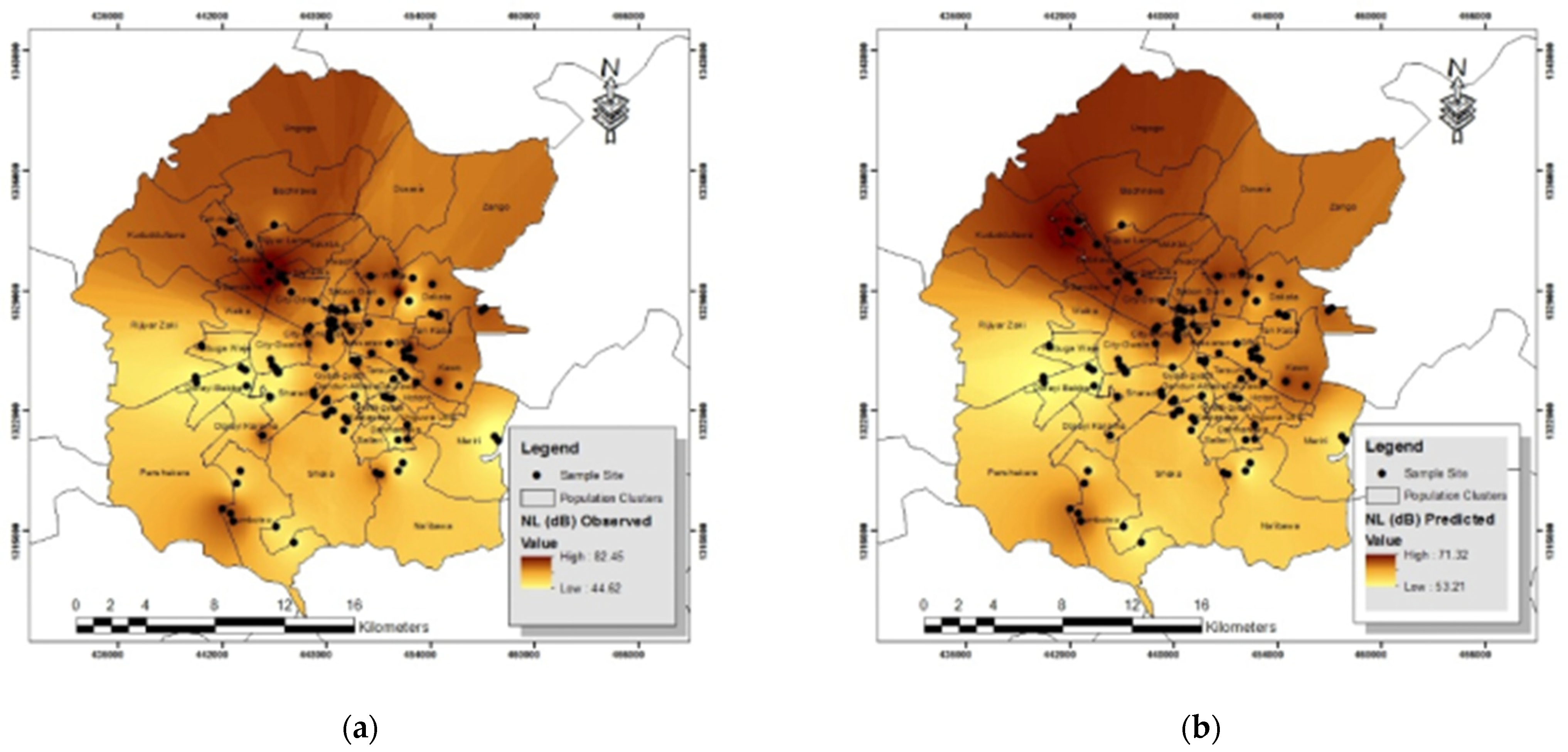
The study area, Kano Metropolis, is the second largest urban center in Nigeria and the administrative capital of Kano State. Kano is located within latitudes 11°50′ to 12°07′ North and longitudes 8°22′ to 8°47′ East [24]. Currently, the city has a population of nearly 5 million inhabitants, has a population density of over 15,000 persons per square kilometer, and a growth rate of 3.9% [24]. Kano Metropolis has assumed the status of city as far back as the 12th century [29] and since then it continues to grow in terms of population and commerce [26]. Kano is arguably the second most important commercial city in Nigeria. Fortunately, the city’s administrators have left the informal development to constitute a larger portion of its landscape [26]. Indeed, the informal development has not only constituted nearly half of its landmass, but even within what is considered formal a lot of informal development exists. A crucial attribute of Kano City is the use of informal commercial transport system which constitutes 60% for public use [20].
A sound level meter (model Graiger TL 200, manufacture by Shenzhen Handsome Technology Co., Ltd, Shenzhen, China) was used to measure the sound level at locations. Noise logger communication application was used to record sound level data into computer at a height of 1.5 as requested by standards. Multi-layer stratification was employed to create the sampling clusters for the study. Land use and housing density formed the basis for the creation of sampling clusters. The study area was classified based on land use into residential, industrial, and commercial areas. The residential areas were further classified based on housing density into low, medium, and high-density areas. In addition, samples were collected from the major metropolitan roads. Thus, the strata for data collection were industrial, commercial, low density residential, medium density residential, high density residential, and traffic corridors.
Thirty-eight sampling areas were used and in each area three points (sampled locations) were selected using convenience sampling techniques—selecting major areas, making a total 114 sampled locations. Global Positioning System (GPS) Garmin 76× (made by Nuvi Accessories, Hong Kong, China) model was used to record the coordinates of the sampled location for GIS analysis. Sound level was measured for seven days. Within each location, data were collected for morning (8–10 a.m.), afternoon (12–2 p.m.), and evening (4–6 p.m.).
All nine major commercial areas of the metropolis, which include Abubakar Rimi (Sabon Gari), Kantin Kwari, Kurmi, Kofar Ruwa, ‘Yankaba, Naibawa (Yanlemo), Rimi, Wapa, and Kofar Wambai markets, were included. This made a total of twenty-seven sampled points. Five industrial areas included are Sharada, Bampai, Tokarawa, Challawa, and Dakata. In each of them, three points were also selected for the data collection. These made a total of fifteen locations with forty-five sampling sites. Twenty-one locations were selected from the four residential clusters within the metropolis. The residential areas in the metropolis were categorized into low, medium, and high density [30]. Another category described as peri-urban metropolitan area was also sampled [31]. The high-density areas include the Birni (old walled city), Gwargwarwa-Tudun Murtala, Kurna Rijiyar Lemo, Unguwa Uku, Giginyu, Naibawa and Sheka. Medium density areas are predominantly new layouts that include: Hausawa, Tarauni, parts of Hotoro, Rijiyar Zaki, Gadon Kaya, Kundila, Shagari Quarters, Gwammaja, Tukuntawa, and Danladi Nasidi. The Low-density areas are mainly the GRAs and Institutional lands. Two of the major GRAs, Nasarawa and NNDC were selected as representatives for this cluster. There are also peri-urban residential areas of Ungogo and Kumbotso to the north and south of the Metropolis. The areas sampled constitute the major spatial clusters in the metropolis [32]. Three additional samples were also selected, one sample from each of institutional (Audu Bako Secretariat), educational (Bayero University), recreational (Race Course). In each sampling location three sites were selected.
To develop a model for noise level, a spatial multiple regression was applied using the geographic weighted regression tool in ArcGIS 10.3. The model is based on Tobler’s First Law of geography and allows for estimation of dependent variable using a set of one or more dependent variables which are measured at a point whose location(s) is/are known. Six sets of variables: population density, land use and land cover, traffic volume, distance from road, and residential subdivision data were used as independents in the model. The choice was based their effect on noise level as identified from the literature, and availability of data on the variable. The model used is an adoption and modification of Sieber et al. [33] and is given as:
y i   ( u ) = β 0 i ( u ) + β 1 i   ( u )   x 1 i + β 2 i   ( u )   x 2 i + β 3 i   ( u )   x 3 i + β 4 i   ( u )   x 4 i + β 5 i   ( u )   x 5 i + β 6 i   ( u )   x 6 i + ε
where β _ 0 i   ( u ) is a parameter that describes a relationship around location u and is specific to that location, y is the noise level dependent variable, x _ 1 , x _ 2 , x _ 3 , x _ 4 ,   x _ 5 and x _ 6 represent the independent variables as listed in Table 1, and ε the error term, describing the account factors that were not captured by this study.
These variables were chosen because of their significant effects in noise prediction as explained [33]. Population determines the level of noise produce, because noise is largely human in nature especially in urban environment. The type of land use generally dictates the activity in the area. Trees are known to attenuate noise, and as such noise studies generally include vegetation cover in their predictions. In a city, areas have different traffic volumes and are located at different distance from the road, hence it is important to include these variables in noise prediction. Noise is likely to vary between formal and informal areas. In Kano Metropolis, almost half of the city has no planning footprint [24].
Population was obtained from the National Population Commission which was based on the 2006 census, and the population cluster was created based on [32] and then projected using the geometric projection method and based on the inter-census growth rates (ICGRs) of different LGAs. The projected population data were used to compute population density and vector map was produced. The results were ranked and then rasterized.
The land use map was produced based on [34]. The map was updated using most recent Google Earth pro data. The land uses were ranked based on intensity of usage and the ability to generate high noise levels. The final vector map was equally rasterized.
For land cover data, a Landsat 8 image of the area for year 2018 was downloaded from the Glovis land cover facility site. The image was used to compute normalized differential vegetation index (NDVI). The NDVI is computed as shown in Equation (2):
N D V I = ( N I R R e d ) / ( N I R + R e d )
where NDVI is the most commonly used image indices for land cover [35,36], NIR is the near infrared region of the electromagnetic spectrum corresponding to band 5 and Red is the red region corresponding to band 4 in Landsat image. The final NDVI product is a value ranging from −1 through 0 to +1 with more positive values indicating vegetation cover.
The major roads’ data were used to create multiple ring buffers using 500 m. The assumption is that as one moves away from the road the noise level will be decreasing. The buffers were ranked in descending order as one gets away from the main road. The final map was also converted to raster.
The traffic volume data were obtained from the Kano Urban Transport Project Office (KUTPO) in the State Ministry of Works, Housing and Transportation. The data were collected for KUTPO intervention by Nigeria Infrastructure Advisory Facility (NIAF), a subsidiary of Adam Smith UK under Department for International Development (DFID) funding. The data were processed for hourly total, and the hourly mean for the day, afternoon, morning, and evening were computed. The data were projected using the 2.5% growth rate proposed [34]. The traffic volume map was produced using the spatial interpolation method in ArGIS based on the fifteen points selected for measuring the traffic noise. The final map was classified, ranked, and changed to raster. Table 2 shows how the ranking was performed for the modelling.
The residential subdivision data were sourced from KUTPO/NIAF 2014. The data had divided Kano City’s residential clusters into low density, medium density, and high-density residential units and into formal and informal areas. These areas were ranked bearing in mind that high density will generate more noise, and that noise will be higher in informal localities. The vector map for the data were produced and then rasterized as carried out for the others.
The sampling locations data were used to extract the raster values using the extraction spatial analyst tool in ArcMap environment of ArcGIS. Data containing the extracted raster values were regressed using the geographic weighted regression with observed mean noise. Final outputs were exported as tables for presentation and for drawing graphical presentation of observed and predicted noise levels.

3. Results

Table 3 shows the descriptive statistics of the noise levels by land use types. The mean noise level of the area is generally high and greater than permissible level for dwelling places [11]. The mean noise level recorded was highest in high density residential and commercial areas and lowest in educational areas. The lowest mean value recorded in the educational area is be attributed to higher tree density in the area as trees is known to absorb a lot of noise. The highest noise level areas were high density residential, commercial, and industrial clusters.
Noise pollution levels were regressed with the parameters to see how they (the variables used) explained noise level. The result of spatial regression analysis is presented in Table 4 which indicates that relationships between noise level and determinants of noise pollution is very significant for mean daily, morning, afternoon, and evening because for each of the four the p–values were less than 0.05. However, the individuals p-values show that population density is the most significant factor by having p = 0.01 and 0.033 for afternoon and evening, respectively. Land cover, which has to do with greening and tree cover, is equally significant at 95% confidence level for morning and afternoon; and is probably significant in evening.
A significant relationship was found between noise level and the set of explanatory variables given a multiple correlation coefficient (multiple R) of 48.7% and coefficient of determination (R2) of 23.7% (Table 5). This indicates that the set of variables in the equation can predict approximately 49% of the noise level (dependent variable) assuming that intercepts were included in the equation and can explain up to 24% of the noise level variation assuming noise variables relation to be non-linear. The adjusted R2 is said to clear the issues that arise from addition of a new variable. Any addition of an independent variable will have a positive effect on the coefficient of determination.
Individually, the variables differ in their contribution to noise level. The most significant variables are land use type, traffic volume, and land cover (Table 6). The model substitute is:
N L = 64.061 + [ ( 19.599 × Land   cover ) + ) 0.259 × Distance   to   road ) + ( 4.017 × Population   density ) + ( 3.210 × Housing   subdivision ) + ( 1.652 × L a n d   u s e ) + ( 0.002 × Traffic   volume ) ] ± 4.58
The descriptive statistics revealed a close relationship between observed and predicted noise level with mean values of 62.19 and 62.21, respectively (Table 7). Standard error and standard deviation are higher in observed areas indicating more variability than expected. This can be linked to extraneous factors that influence noise pollution outside ones considered by the study including ceremonial activities, wedding, as well as the type of building and road construction material, culture, and societal values.
The maps for and quartile plots of mean observed and predicted noise levels are presented in Figure 1a,b, respectively, and Figure 2a,b, respectively.
Figure 1a shows observed noise and Figure 1b predicted noise of Kano Metropolis. Looking at Figure 2a,b, one can see some semblance between observed and predicted noise maps. From the figure, the extreme values were adjusted in the predicted level. The two maps had an almost similar pattern, except that most high and most low values were found in the measured map. In both maps, noise level is highest in the Centre (Old City), to the northwest and east, which are the most densely populated. While the range of the observed noise level were 44.62 to 82.45 dB, the expected, which is depicted by the predicted, is 53.21 to 71.32 dB.

4. Discussion

The mean levels in all locations were above the permissible limit. This finding agrees with [19], [6] that reported higher noise above the recommended levels in two Nigerian cities. As expected, that higher population is in congruence with higher noise pollution [37]. Noise is governed by several factors. Among the factors are population [38], land use [39,40], distance from the road and traffic volume [41], and presence or absence of planning in the area [42].
Population is the most important factor explaining sound level. The next most contributing factors are traffic volume, distance from road, and land use with lowest p-value equal to 0.179 0.032, and 0.039, respectively. The least contributing factor is housing density with all p-values greater than 0.05. In the evening noise largely come from traffic sources which is very high, hence road is the most contributory factor. This finding corroborates [43] which stated that traffic is the most contributing pollution source in urban areas. In the morning, noise is largely contributed to by land use. The coefficient of determination ranges 16.3% and 26.8% for the afternoon and morning hours. The finding also reveals that apart from the factor used there may be other determinants of noise pollution, such as the ceremonial activities, wedding activity, and types building material, vegetation cover, culture, and societal values. Hence, there is a need to study noise pollution and noise explanation from people’s perspectives. Indeed, the study of noise pollution in New York by [44] noted that explanations of noise pollution using land use and traffic data were found to be limited and have significant uncertainty, especially in large cities where building is diverse and natural environments heterogeneous. The uncertainty may even be more in Kano Metropolis where planning is generally lacking, regulation is poorly enforced, and land uses are too interwoven and mixed.
The adjusted R2 points to the actual effect of explanatory variables subtracting influence arising directly from the addition of a new variable even if the variable has no effect. The standard error of an estimate of 10 indicates the expected difference between the observed and predicted noise level as 10 dB (A). While an R2 square is quite small, the p-value indicates the significant effect of the independent variables (p = 0.000). Indeed, the coefficient of determination is larger than the 0.13 found by [33] in Western Cape, South Africa. As explained by [33], noise level is difficult to model with high level accuracy because of the influence of many factors, some of which are situational and characterized by high uncertainty. However, [45] found an R2 of 60.1% while modelling traffic noise in Dhanbad township in the eastern part of India. A study of noise pollution in New York, [44] also reported a significant effect of the explanatory variables on noise pollution using land use and traffic data; however, they noted limited and significant uncertainty, especially in large cities where building is diverse and natural environments heterogeneous. The uncertainty may even be higher in the Kano Metropolis where planning is generally lacking, regulations are poorly enforced, and land uses are interwoven and mixed. The study also indicates inequality in the noise level at a city level, with noise being higher in more informal area were residents are poor [46].
The residuals and other model parameters for samples’ location gave more information about the model. From the appendix, 73% of the residuals are below 5, indicating the closeness between observed and predicted values. Only 9% of the residual are up to 10dB, and most of these were observed in commercial and high-density residential areas where factors that can easily lead to wide variation in noise level exist. Moreover, the nature of noise being highly situational led to a wide gap in its prediction.
This is attributed to other factors that may influence noise which the regression equation model has not captured. The normality plots in Figure 2a,b reveal more similarity between observed and predicted noise in the areas with R2 of 0.99 and 0.98, respectively. In the observed areas there are more values above the regression line than in the prediction, which may be attributed to the modelling effect which always simplifies a complex relation. Because the model is an abstraction of reality, it tends to simplify a situation compared with reality.

5. Conclusions

Noise is generally higher in informal urban settings where land uses are not well segregated and noise legislation is weakly enforced. The study demonstrates that it is possible to develop a model to predict noise in such a setting; the model’s power is, however, quite low due to the nature and uncertainty of noise generating factors. The most significant factors for the prediction of noise pollution are population, traffic volume, distances from road, and land use. The other variables that influence noise were not considered by this study because they are not accessible, such as events and ceremonies, which make noise prediction highly uncertain. To address the noise problem, therefore, this study found urban planning imperative. Urban planning is a panacea to many environmental problems such as noise pollution. Noise is generally high in informal settings, as observed by this study. The government should provide more and improve access to formal lands in urban areas. The proliferation and sprawl of informal areas should be checked. Sound is part of the livability of an urban center; city administration should pay attention to provision of open and recreational sites to improve the city’s soundscape. Preliminary guidelines supporting the reduction in noise in the urban space should be developed and enforced by the city administrators.

Author Contributions

Conceptualization, M.U.M. and M.M.B.; methodology, Z.U.Z. and F.U.; software, M.K.M.A.; validation, F.U.; formal analysis, A.I.A. and M.K.M.A.; investigation, M.U.M.; resources, A.I.A.; data curation, O.A.A.; writing—original draft preparation, O.A.A. and Z.U.Z.; writing—review and editing, Z.U.Z., A.I.A., and O.A.A.; visualization, T.M.H., K.H.I., and O.A.A.; supervision, J.O.D.; project administration, O.A.A. and K.H.I.; funding acquisition, A.I.A., K.H.I., and O.A.A. All authors have read and agreed to the published version of the manuscript.

Funding

The authors extend their appreciation to the Deanship of Scientific Research at Imam Mohammad Ibn Saud Islamic University for funding this work through Research Group no. RG-21-09-50.

Institutional Review Board Statement

Not applicable.

Informed Consent Statement

Not applicable.

Data Availability Statement

Not applicable.

Conflicts of Interest

The authors declare no conflict of interest.

References

  1. Sharma, A.; Vijay, R.; Sardar, V.K.; Sohony, R.A.; Gupta, A. Development of Noise Simulation Model for Stationary and Mobile Sources: A GIS-Based Approach. Environ. Model. Assess. 2010, 15, 189–197. [Google Scholar] [CrossRef]
  2. Huang, G.; Lee, D.; Scott, M. Spatial and Spatio-temporal Epidemiology An integrated Bayesian model for estimating the long-term health effects of air pollution by fusing modelled and measured pollution data: A case study of nitrogen dioxide concentrations in Scotland. Spat. Spatio-Temporal Epidemiol. 2015, 15, 63–74. [Google Scholar] [CrossRef]
  3. Sharma, A.; Vijay, R.; Sohony, R.A. Development of GIS based Noise Simulation Software (DGNSS). Int. J. Sci. Eng. Res. 2013, 4, 177–182. [Google Scholar]
  4. Pritam, S.P.; Pandey, U.; Singh, G. Assessment of Outdoor and Indoor Noise. Int. J. Emerg. Reasearch Technol. 2014, 3, 226–231. [Google Scholar]
  5. Baloye, D.O.; Palamuleni, L.G. A Comparative Land Use-Based Analysis of Noise Pollution Levels in Selected Urban Centers of Nigeria. Int. J. Environ. Res. Public Health 2015, 12, 12225–12246. [Google Scholar] [CrossRef] [PubMed]
  6. Adejobi, F.S.; Alli, O.S. Analysis of Noise Pollution Levels on Various Landuse Pattern in Lagos State. In Proceedings of the 57th Annual Conference of the Association of Nigerian Geographers (UNILAG ANG- 2016), Lagos, Nigeria, 10–15 April 2016. [Google Scholar]
  7. Kurakula, V.; Skidmore, A.K.; de Kluijver, H.; Stoter, J.E.; Dabrowska-Zielinska, K.; Kuffer, M. A GIS-Based Approach for 3D Noise Modelling using 3D City Models; International Institute for Geo-Information Science and Earth Observation: Enschede, The Netherlands, 2007. [Google Scholar]
  8. Had\vzi-Nikolova, M.; Mirakovski, D.; Delipetrov, T.; Arsov, P. Noise Dispersion Modelling in Small Urban Areas with CUSTIC 3.2 Software. Int. J. Emerg. Technol. Adv. Eng. 2012, 2, 2–6. [Google Scholar]
  9. Brainard, J.S.; Jones, A.P.; Bateman, I.J.; Lovett, A.A. Exposure to Environmental Urban Noise Pollution in Birmingham, UK. Urban Stud. 2004, 41, 2581–2600. [Google Scholar] [CrossRef]
  10. Babisch, W.; Danny, H.; Göran, P.; Klea, K.; Manolis, V.; Ennio, C.; Lars, J. Hypertension and Exposure to Noise Near Airports: Results of the HYENA Study. In Proceedings of the 9th International Congress Noise as a Public Health Problem, Foxwoods, CT, USA, 21–25 July 2008; Volume 10. [Google Scholar]
  11. Nagodawithana, N.S.; Pathmeswaran, A.; Pannila, A.S.; Wickramasinghe, A.R.; Sathiakumar, N. Environmental Pollution by Traffic Noise in the City of Colombo, Sri Lanka. Asian J. Water, Environ. Pollut. 2016, 13, 67–72. [Google Scholar] [CrossRef]
  12. Torija, A.J.; Ruiz, D.P. A general procedure to generate models for urban environmental-noise pollution using feature selection and machine learning methods. Sci. Total Environ. 2015, 505, 680–693. [Google Scholar] [CrossRef] [PubMed]
  13. Smith, R.B.; Beevers, S.D.; Gulliver, J.; Dajnak, D.; Fecht, D.; Blangiardo, M.; Douglass, M.; Hansell, A.L.; Anderson, H.R.; Kelly, F.J.; et al. Impacts of air pollution and noise on risk of preterm birth and stillbirth in London. Environ. Int. 2019, 134, 105290. [Google Scholar] [CrossRef] [PubMed]
  14. Tonne, C.; Halonen, J.; Beevers, S.D.; Dajnak, D.; Gulliver, J.; Kelly, F.J.; Wilkinson, P.; Anderson, H.R. Long-term traffic air and noise pollution in relation to mortality and hospital readmission among myocardial infarction survivors. Int. J. Hyg. Environ. Heal. 2016, 219, 72–78. [Google Scholar] [CrossRef]
  15. Chaturvedi, S.K.; Singh, S. Status of Noise Pollution on Certain Traffic Places in Allahabad City, U.P. India. Int. J. Sci. Eng. Res. 2017, 5, 2015–2018. [Google Scholar]
  16. Ismail, S.; Ahmed, S. Noise Pollution, Its Sources and Effects: A Case Study of University Students in Delhi. EPRA Int. J. Econ. Bus. Rev. 2018, 259, 137–144. [Google Scholar]
  17. Ali, A.F.; Abdullahi, H.; Tanko, A.I.; Sharfadeen, K.I. Water Supply and Sanitation Challenges in Dala Local Government Area of Water Supply and Sanitation Challenges in Dala Local Government Area of Kano State, Nigeria. Dutse J. Pure Appl. Sci. (DUJOPAS) 2018, 4, 604–611. [Google Scholar]
  18. Tang, U.; Wang, Z. Influences of urban forms on traffic-induced noise and air pollution: Results from a modelling system. Environ. Model. Softw. 2007, 22, 1750–1764. [Google Scholar] [CrossRef]
  19. Anomohanran, I.J.C.; Iwegbue, O.; Oghenerhoro, C.M.A.; Egbai, I.O. Investigation of Environmental Noise Pollution Level of Abraka in Delta State, Nigeria. Trends Appl. Sci. Res. 2008, 3, 292–297. [Google Scholar] [CrossRef]
  20. Mohammed, M.U.; Falola, J.A.; Badamasi, M.M. Spatial Distribution of Traffic induce noise pollution in Kano Metropolis, Nigeria. Wudil J. Earth Environ. Sci. 2021, 1, 52–58. [Google Scholar]
  21. Adam, B.M.; Abubakar, A.H.; Mohammed, M.U.; Mani, A.H. Assessment of Noise from Diesel Generators Used in GSM Base Stations in Kano Metropolis, Nigeria. FUDMA J. Sci. (FJS) 2020, 4, 226–234. [Google Scholar]
  22. Alkasim, S.T.; Abubakar-Sadiq, A. Effect of human activities on noise level measurement of some selected areas of Kano metropolis, Kano State Northern Nigeria. Niger. J. Phys. 2010, 21, 1–5. [Google Scholar]
  23. Ibrahim, A.M. Paying for the Priceless: The Consequences of Air and Noise Pollution in Some Commercial Areas of Kano Metropolis. Int. J. Humanit. Soc. Sci. Invent. 2014, 3, 17–21. [Google Scholar]
  24. Mohammed, M.U.; Hassan, N.I.; Badamasi, M.M. In search of missing links: Urbanisation and climate change in Kano Metropolis, Nigeria. Int. J. Urban Sustain. Dev. 2019, 11, 309–318. [Google Scholar] [CrossRef]
  25. Mohammed, M.U.; Musa, I.J.; Jeb, D.N. GIS-Based Analysis of the Location of Filling Stations in Metropolitan Kano against the Physical Planning Standards. Am. J. Eng. Res. 2014, 3, 147–158. [Google Scholar]
  26. Barau, A.S. Land Degradation and Environmental Quality Decline in Urban Kano. Kano: State Soc. Econ. 1967, 2017, 141–170. [Google Scholar]
  27. Agarwal, B.L.; Swami, S. Noise Annoyance under Interrupted Traffic Flow Condition for Jaipur City. Int. J. Appl. Sci. Eng. 2009, 7, 159–168. [Google Scholar]
  28. Francis, J.M. Determining Thresholds of Annoyance to Tones in Noise. Master’s Thesis, University of Nebraska, Lincoln, NE, USA, 2014. [Google Scholar]
  29. Liman, M.A.; Adamu, Y.M. Kano in time and space: From a city to a metropolis. In Perspective on Kano British Relations; Hambolu, M.O., Ed.; Gidan Makama Museum: Kano, Nigeria, 2003; pp. 144–169. [Google Scholar]
  30. Maiwada, A.D. Disappearing open spaces in Kano Metropolis. In Issues in Land Development and Administration, Proceeding of the National Workshop on Land Administration and Development in Northern Nigeria, Kano, Nigeria, 25–28 September 1986; Falola, J.A., Ahmed, K., Liman, M.A., Eds.; Department Geography, Bayero University: Kano, Nigeria, 2000; pp. 3–9. [Google Scholar]
  31. Nabegu, A.B. An Analysis of Municipal Solid Waste in Kano Metropolis, Nigeria. J. Hum. Ecol. 2010, 31, 111–119. [Google Scholar] [CrossRef]
  32. Hassan, N.I. Population Clusters and Commercial Bus Movement Generation in Kano Metropolis. Unpublished M.Sc. Thesis, Bayero University, Kano, Nigeria, 2016. [Google Scholar]
  33. Sieber, C.; Ragettli, M.S.; Brink, M.; Toyib, O.; Baatjies, R.; Saucy, A.; Probst-Hensch, N.; Dalvie, M.A.; Röösli, M. Land Use Regression Modeling of Outdoor Noise Exposure in Informal Settlements in Western Cape, South Africa. Int. J. Environ. Res. Public Health 2017, 14, 1262. [Google Scholar] [CrossRef] [PubMed]
  34. Kano Urban Transport Planning Office KUTPO. Conceptual Design of Pilot Scheme for Lowering Carbon Emission in Old Kano City; Kano Urban Transport Planning Office KUTPO: Kano, Nigeria, 2017. [Google Scholar]
  35. Chen, X.; Yang, D.; Chen, J.; Cao, X. An improved automated land cover updating approach by integrating with downscaled NDVI time series data. Remote Sens. Lett. 2015, 6, 29–38. [Google Scholar] [CrossRef]
  36. Zhao, L.; Zhang, P.; Ma, X.; Pan, Z. Land Cover Information Extraction Based on Daily NDVI Time Series and Multiclassifier Combination. Math. Probl. Eng. 2017, 2017, 1–13. [Google Scholar] [CrossRef]
  37. Cox, W. How Urban Density Intensifies Traffic Congestion and Air Pollution; Goldwater Institute: Phoenix, AZ, USA, 2000. [Google Scholar]
  38. Sakieh, Y.; Jaafari, S.; Ahmadi, M.; Danekar, A. Green and calm: Modeling the relationships between noise pollution propagation and spatial patterns of urban structures and green covers. Urban For. Urban Green. 2017, 24, 195–211. [Google Scholar] [CrossRef]
  39. Chauhan, B.; Pawar, A.; Kumar, M.; Shukla, D.; Kumar, S.K.; Mohit, P. Assessment of noise level in different zones of Haridwar City, Uttarakhand. Researcher 2010, 2, 50–53. [Google Scholar]
  40. Kirankumar, P.A.; Sudamprasad, P.P.; Champakbhal, N.A.; Bhikhubhai, P.C. Analysis of noise pollution due traffic in Vadodara City. Int. Res. J. Eng. Technol. 2016, 3, 1738–1741. [Google Scholar]
  41. Chowdhury, A.; Debsarkar, A.; Chakrabarty, S. Critical analysis of day time traffic noise level at curbside open-air microenvironment of two types of road network of a big city. J. Environ. Occup. Sci. 2015, 4, 185. [Google Scholar] [CrossRef]
  42. Margaritis, E.; Kang, J. Relationship between green space-related morphology and noise pollution. Ecol. Indic. 2017, 72, 921–933. [Google Scholar] [CrossRef]
  43. Garg, N.; Sinha, A.; Gandhi, V.; Bhardwaj, R.; Akolkar, A. A pilot study on the establishment of national ambient noise monitoring network across the major cities of India. Appl. Acoust. 2016, 103, 20–29. [Google Scholar] [CrossRef]
  44. Kheirbek, I.; Ito, K.; Neitzel, R.; Kim, J.; Johnson, S.; Ross, Z.; Eisl, H.; Matte, T. Spatial Variation in Environmental Noise and Air Pollution in New York City. J. Hered. 2014, 91, 415–431. [Google Scholar] [CrossRef] [Green Version]
  45. Debnath, A.; Singh, P.K. Environmental traffic noise modelling of Dhanbad township area–A mathematical based approach. Appl. Acoust. 2018, 129, 161–172. [Google Scholar] [CrossRef]
  46. Dreger, S.; Schüle, S.A.; Hilz, L.K.; Bolte, G. Social Inequalities in Environmental Noise Exposure: A Review of Evidence in the WHO European Region. Int. J. Environ. Res. Public Health 2019, 16, 1011. [Google Scholar] [CrossRef] [PubMed] [Green Version]
Figure 1. (a) observed noise and (b) predicted noise of Kano Metropolis.
Applsci 12 09071 g001
Figure 2. (a) Normality of observed noise level and (b) normality of predicted noise level.
Applsci 12 09071 g002
Table 1. List of independent variables used in Equation (1).
Independent Variable NameSymbol
x _ 1 land cover
x _ 2 distance from road
x _ 3 population density
x _ 4 residential subdivision
x _ 5 land use
x _ 6 traffic volume
Table 2. Variable Used and Their Ranking for the Modelling.
Land Use TypeCode
Administrative/Open1
Educational2
Low Density Res.3
Medium Density Res.4
High Density Res.5
Industrial6
Commercial7
Distance from main road (km)Code
<0.250.70
0.025 to 0.50.20
0.6–1.00.050
1.0–2.00.045
2.0–4.00.005
>4.00.000
Population DensityCode
0.0–25000.10
2501–62620.20
6263–20,6660.30
20,667–40,7050.40
40,706–79,8460.50
Land CoverNDVI value
Traffic VolumeAbsolute Volume data
Table 3. General Distribution of Noise Land use type in dB(A).
Land UseMeanStdvNCV (%)Maximum Permissible Sound Level by WHO/NESREA
Commercial65.511.20750,69917.155
Educational51.287.3379,18014.345
Industrial64.6612.00353,88118.660
Institutional63.1812.9575,93620.545
High Density Residential66.9914.42599,99221.550
Low Density Residential58.0712.52161,11521.650
Medium Density Residential58.0113.22766,97222.850
Peri-urban Resd.60.0711.77143,87119.650
Recreational63.5112.7848,75220.145
Table 4. Factor Determining the Noise Level.
ModelUnstandardized CoefficientsStandardized CoefficientstSig.r2
BS. ErrorBeta
Morning(Constant)52.9275.543 9.5490.0000.268
Distance from Road5.5823.2460.1551.720.088
Land Use109.58352.5140.1932.0870.039
Land Cover63.107−26.40411.118−2.3740.019
Population Density10.16.1210.161.650.102
Residential Subdivision2.2415.2190.0380.4290.668
Traffic Volume−0.0010.001−0.109−1.20.232
Afternoon(Constant)63.3947.231 8.7670.0000.163
Distance from Road 0.5584.2020.0120.1330.895
Land Use5.62568.5050.0080.0820.935
Land Cover66.092−35.26715.060−2.3420.021
Population Density26.3518.0160.3233.2870.001
Residential Subdivision7.1226.7660.0951.0530.295
Traffic Volume−0.0010.001−0.134−1.4450.151
Evening(Constant)56.2376.77 8.3070.0000.227
Distance from Road 8.5833.9640.1972.1650.032
Land Use95.23864.1380.1391.4850.140
Land Cover65.386−22.06013.818−1.5960.113
Population Density11.3167.4750.1481.5140.033
Residential Subdivision−4.526.374−0.064−0.7090.48
Traffic Volume−0.0010.001−0.083−0.9040.368
All bold are significant at 0.05 level.
Table 5. Model Summary.
Multiple R0.487
R Square0.237
Adjusted R Square0.193
Std. Error of the Estimate10.120
Log-likelihood Function Value−368.923
p-value0.000
Table 6. Coefficients of Regressions.
Unstandardized
Coefficients
Standardized
Coefficients
TSig.
BStd. ErrorBetaStd. Error
(Constant)64.0614.578 13.9930.000
Land cover (ndvi)−19.59910.610−0.1950.106−1.8470.068
Dist. Road−0.2592.457−0.0100.093−0.1050.916
Pop. Density4.0174.6110.0880.1010.8710.386
Housing Density3.2103.8320.0770.0910.8380.404
Land use1.6520.4990.3270.0993.3150.001
Traffic Volume−0.0020.001−0.2530.093−2.7300.007
Table 7. Summary Statistics of the Observed and Predicted Noise Levels.
ObservedPredicted
Mean62.1962.21
Standard Error0.740.39
Standard Deviation7.784.13
Kurtosis−0.44−0.50
Skewness0.02−0.34
Range38.4118.26
Minimum44.5253.08
Maximum82.9271.33
Publisher’s Note: MDPI stays neutral with regard to jurisdictional claims in published maps and institutional affiliations.

