1. Introduction
Research in the field of hydrogeology has been increasing in recent decades due to the growing needs of farmers, livestock breeders and municipalities [
1,
2,
3]. In this respect, there is a great deal of ignorance, which has led to considerable failures and economic losses. For this reason, it is common to find sites for water catchment works whose location techniques have been based on dowsing [
4], while in recent decades, the use of geophysical techniques has become more widespread with the use of mostly vertical electrical soundings [
5,
6,
7].
Currently, there is a greater variety of tools for the resolution of this type of problem, depending on the geological structure of the basin to be studied. In this case, we wanted to test the use of Transient Electromagnetics or Time-Domain Electromagnetic (TEM/TDEM) soundings in Mesozoic formations. With this tool, we wanted to check and corroborate the initial bibliographic data found in the Geological and Mining Institute of Spain to locate future exploitations and solve hydrogeological problems in this type of geological formation.
The Electromagnetic Sounding technique is a methodology that emerged in the 1980s, using analogue equipment [
8]; it is quite unknown to many today, and in the 21st century, it has evolved to a greater extent compared to its predecessors [
9,
10,
11,
12,
13].
In the same way as vertical electrical soundings, this type of method is commonly used for the definition of sub-horizontal structures, although Electromagnetic Soundings show a greater focalisation and less affection of lateral changes, which makes it a technique of greater accuracy in such geological contexts where faults are frequent. This is our main reason for choosing this geophysical prospecting system since we also aimed to validate its potential for the execution of future projects of the same nature.
In order to confirm this tool in this type of geological environment, we carried out a study in the municipality of Liceras (Soria, Spain). For some time now, the population of Liceras has suffered high levels of arsenic contamination from the current catchment. In addition to this main catchment, the municipality has two other secondary catchments in a Triassic formation that have been set up over time. The lack of hydrogeological studies for the location of these boreholes has meant that very poor-quality water is obtained from these complementary catchments.
Aware of this problem, the Liceras Town Council requested the help of the Regional Government of Castile and Leon to solve the issue. The municipality has always located the boreholes to the south of Liceras, in a very unfavourable area from a hydrogeological point of view.
Until now, the main supply point in the area has been a catchment located on Triassic outcrops, capturing the resources available in the Upper Triassic materials: sandstones of the “Lutitas con yesos y Valderromán” formation. Their low hydrochemical quality, together with the insufficient flow, has led to the need to explore the use of resources from the Liassic formations outcropping to the northeast. There, the “Imón and Cortes de Tajuña” formation, with its folded dolomites and carniolas, has become the target formation.
The determination of a new site for water extraction is conditioned by two factors: the identification of the position of the target formation and the avoidance of entering the underlying Triassic formations of low water quality, thereby ensuring the best prospects from the point of view of usable flows and hydrochemical quality.
A geological-geophysical study using the Time-Domain Electromagnetic technique was carried out with the aim of structurally delimiting the formations defined by the geological map so that, on the basis of the results, the best possible location for the new borehole could be determined, as well as its depth. The study results combine the pre-existing data with the geophysical data obtained to show the value of a tool that can solve similar problems in Mesozoic formations due to the significant resistivity contrast among the Cretaceous, Jurassic and Triassic. Therefore, this methodology can produce savings for both public and private institutions in their investment in hydrogeological Mesozoic resources.
2. Geological Context
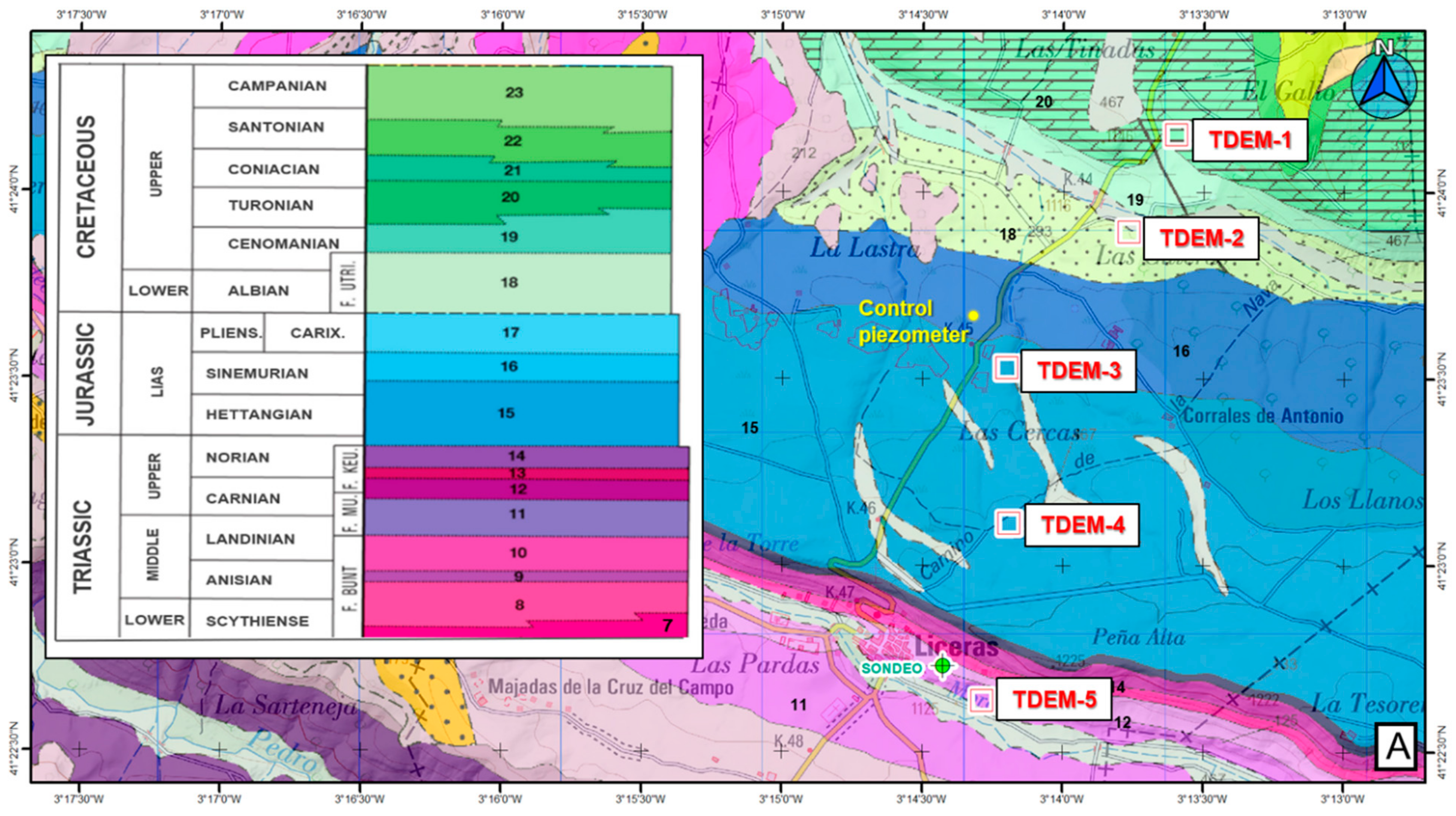
The study area is located in the southeastern sector of the tertiary basin of the Duero River, on Triassic, Jurassic and Cretaceous outcrops belonging to the Mesozoic cover that fossilises the bedrock.
The Mesozoic succession outcropping in the study area presents a slightly dipping structure (10–20°) towards the northeast. The lower base is made up of materials of the Keuper facies, on top of which Jurassic carbonate materials are found, and finally, the Cretaceous formation.
The Keuper is composed of shales with gypsum and sandstones from the “Lutitas con yesos de Valderroman” formation. This is a sequence of some 60–70 m in thickness whose base is located on a level of sandstone on which the town of Liceras is located. There are various metric sandstone sections with silt intercalations producing topographic reliefs, as well as sections of shales and siltstones and dolomitic clayey loams with secondary gypsum crystals.
The Keuper facies culminate in a dolomitic section present throughout the northern sector of the Castilian branch of the Iberian Mountain Range (Cordillera Ibérica), “Dolomías tableadas de Imón” formation, still from the Upper Triassic (Norian) [
14]. From a cartographic point of view, this formation is integrated with the Cortes de Tajuña Fm., formed by dolomitic breccias and dolomites of massive aspect; they show a combined thickness of about 112 m that can be divided into up to four sections or members.
The Middle Jurassic, Lower Pleinsbachian Sinemurian, appears in a concordant contact, formed by the “Cuevas Labradas” Fm. [
14], consisting of limestones and folded dolomites, which at some points, can reach over 100 m in thickness.
Finally, and in the case of the Jurassic, on the sharply folded limestones of the “Cuevas Labradas” Fm., the Upper Jurassic materials appear, made up of marls and bioclastic limestones of the “Cerro del Pez” Fm. and bioclastic limestones of Barahona, with an approximate thickness of around 20 m. The entire Jurassic section is considered the target for any catchment.
Above the Jurassic, we find the Cretaceous sequence belonging to the “Proto-Atlantic Domain” of the Iberian Basin, and within this, to the North-Castilian Plateau [
15], whose base is made up of the clayey sands of the Lower Cretaceous (“Utrillas Fm”.), followed by the marls and marly limestones of the “Margas” Fm. plus limestones from the “Picofuentes” Fm., and limestones and dolomites of the Lower Cretaceous.
3. Geology of the Study Area
The analysis of the geology in the vicinity of the study area defines a relatively simple structure in which the outcropping Mesozoic sequence dips gently to the northeast. The contact between the Triassic and Jurassic materials (the target formation of the catchment) can be defined with some clarity on the surface, given the topographic contrast between those materials generated by the sandy sections and the lithological banks between them, in addition to the topographic relief that occurs just to the north of the town of Liceras.
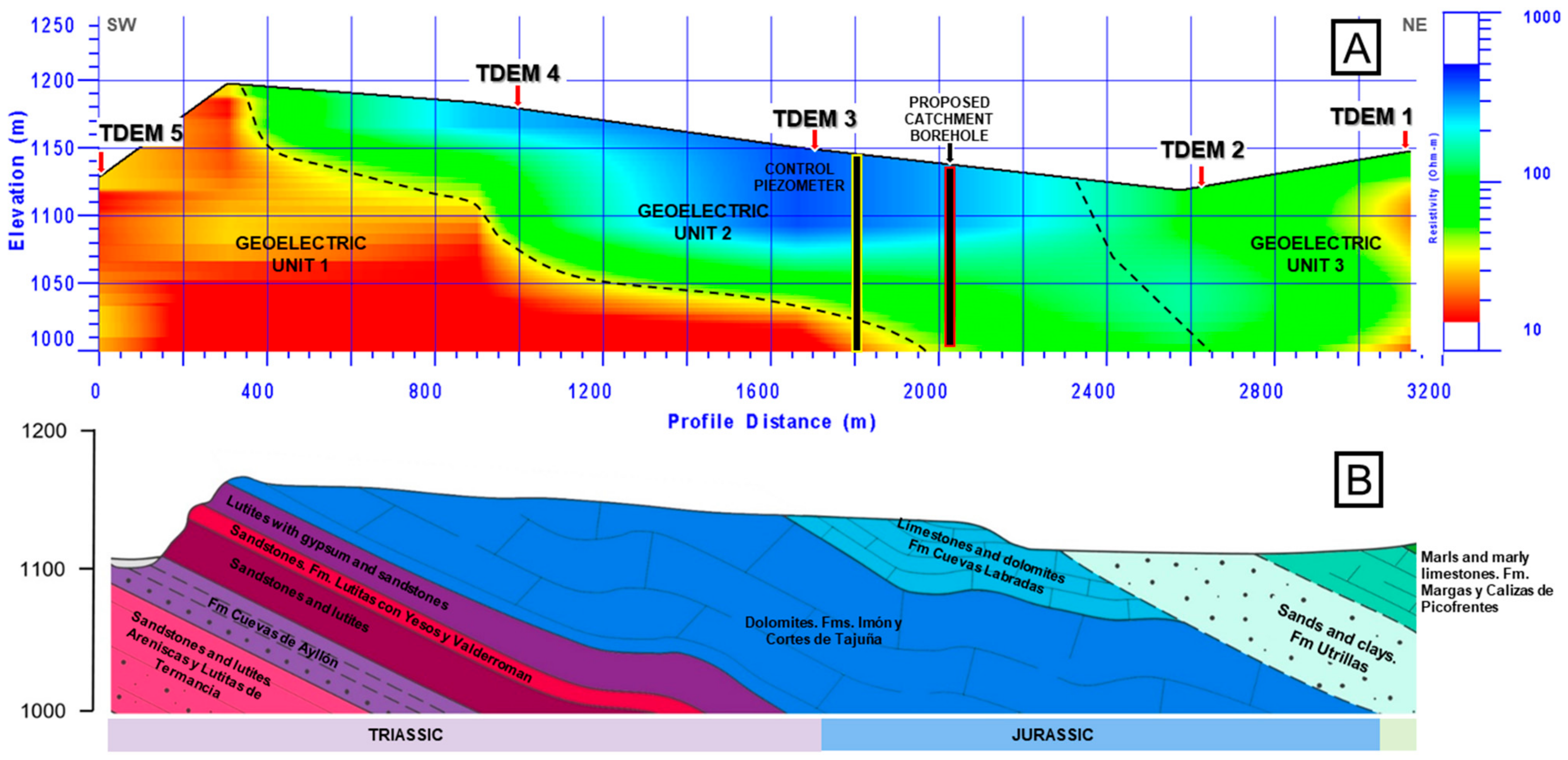
Geological cartography (
Figure 1) allows the generation of geological cross-sections that initially show the structure, position and height of the geological formations, including the main target formation (Jurassic materials).
4. Hydrogeological Context
From the hydrogeological point of view, the study area belongs to the Almazán Sur Groundwater Body (ES020MSBT000400050), belonging to the Duero River Basin, with a defined surface area of 1032 km2 and in which two groundwater formations of interest are defined:
The main aquifer—Jurassic—is made up of dolomites, carniolas and limestones of the formations corresponding to the “Infralías” and “Lías” of the Iberian Mountain Range (Cordillera Ibérica). They have sections of variable permeability due to fissuring and/or karstification, and they behave as free aquifers.
From a hydrogeological point of view, the Upper Cretaceous carbonate series of the domain of the Northern Edge of the Central System (Sistema Central), with permeability associated with fissuring and/or karstification, are of interest. They constitute a—Cretaceous—aquifer that overlaps and disconnects from the Jurassic aquifer due to the existence of a low-permeability detrital formation between the two, made up of the sands of the “Utrillas” Fm.
The Jurassic aquifer formation is confined and disappears to the north, under the Cretaceous aquifer formation, which, at the same time, goes under Tertiary materials towards the Almazán basin. There, it constitutes the main deep aquifer, which feeds the Tertiary detrital materials and significant springs and watercourses, constituting the important Groundwater Body of the Almazán Basin, as well as that of the Páramo de Escalote. The following figure (
Figure 2) shows the definition of the Almazán Sur Groundwater Body and the bordering bodies, as well as the location of the research area within the body.
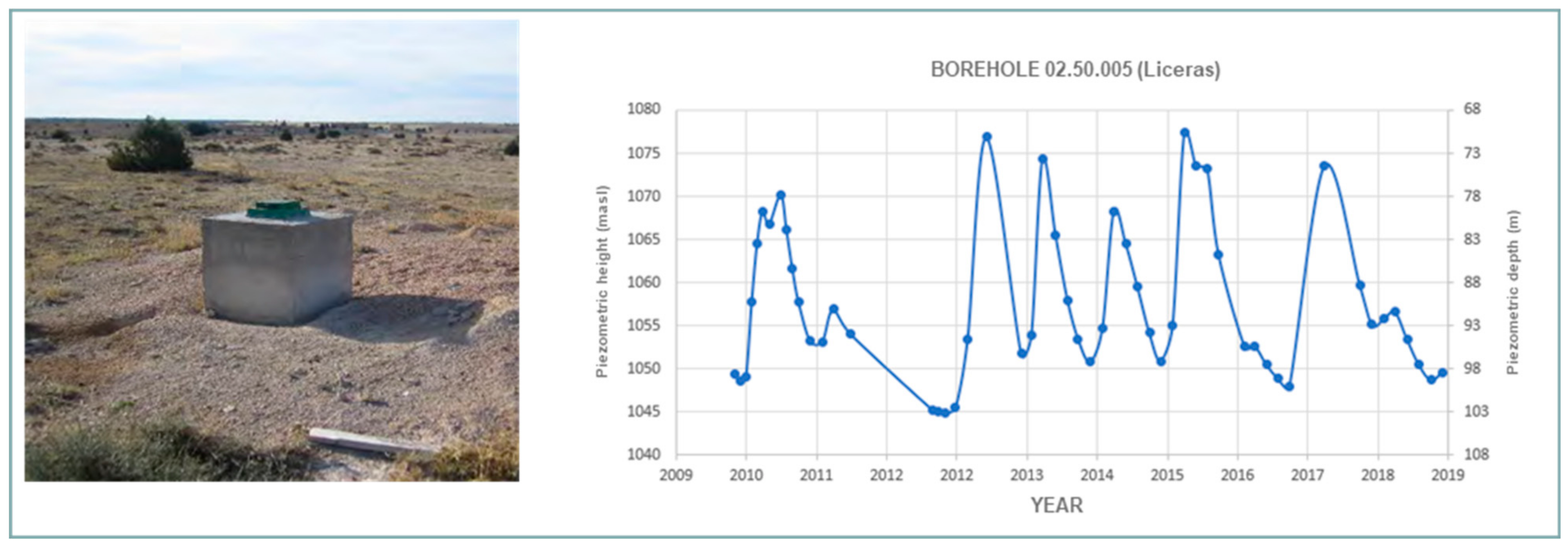
The present research focuses on the Jurassic aquifer formation shortly before it is confined by Cretaceous materials, as it is expected to provide a higher quality source of resources and solve the existing problems at Liceras associated with the poor hydrogeological characteristics of the Triassic materials with a high content of salts due to their lutitic and gypsum materials. In the area, the public body Confederación Hidrográfica del Duero has a borehole used as a control piezometer for the Jurassic materials, called PZ0250005, located 1.6 km to the north of Liceras. This borehole is 205 m deep and with very plastic red and grey clays at the bottom (possibly Keuper). The piezometric level is monitored periodically (
Figure 3), with the base level at 103 m depth in the driest periods and around 70 m depth in the periods of greatest recharge.
5. Geophysical Technique Used: Time-Domain Electromagnetic Sounding (TDEM)
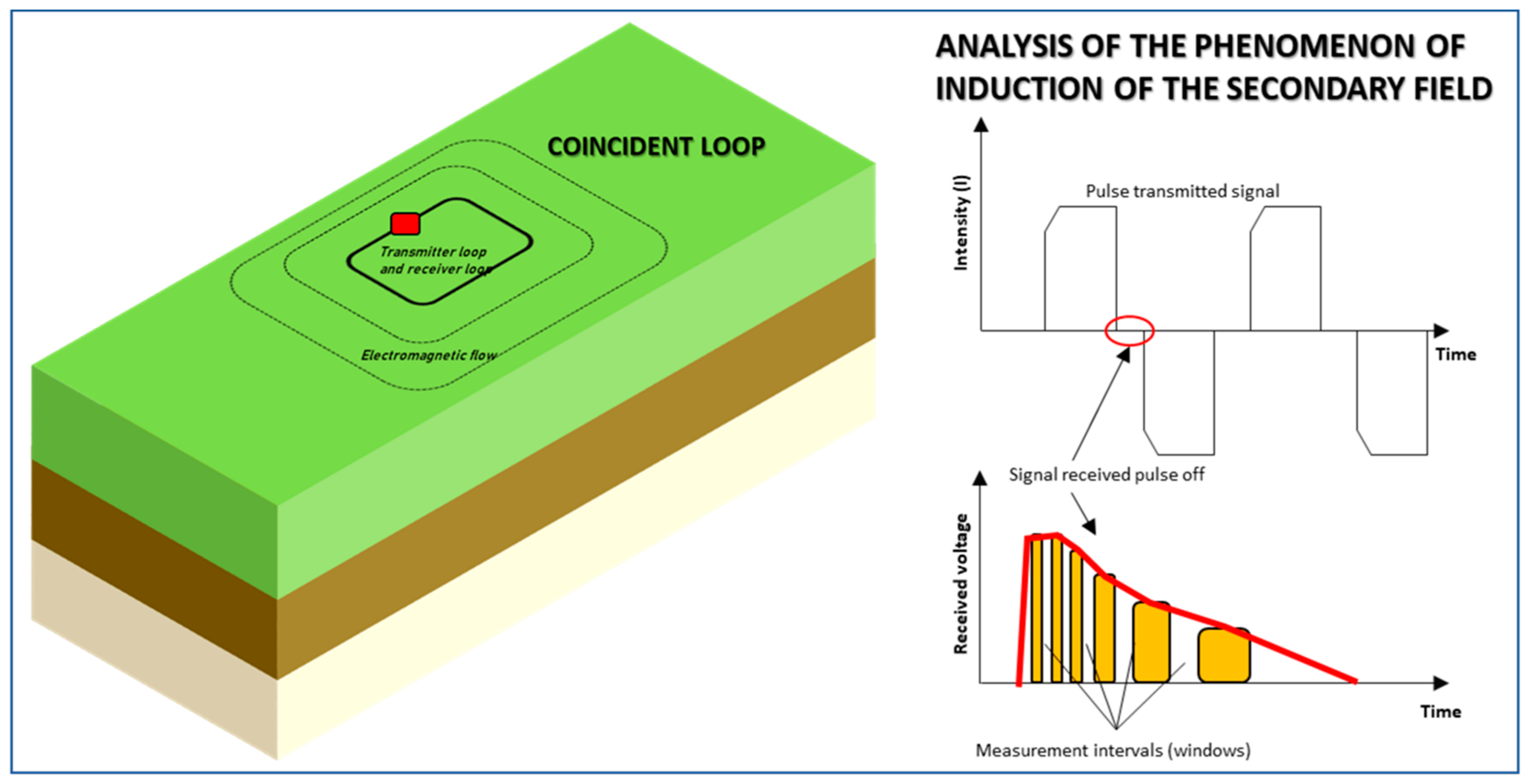
According to Carrasco [
18], time-domain electromagnetic sounding, commonly referred to as TDEM, consists of injecting a constant current into a loop or transmitting coil (TX), generating a constant primary magnetic field. When the current flowing through the transmitting coil (TX) is suddenly interrupted, the primary magnetic field is no longer constant and decreases in value over time until reaching zero. According to Faraday’s law, when a body is exposed to a time-varying magnetic field, a series of electromagnetic inductions of electric currents occur in the subsurface (
Figure 4). These currents flow in closed paths through the subsurface, migrating in depth and laterally, decreasing in strength over time and, in turn, generating a decreasing transient secondary magnetic field at the surface [
19].
This secondary field induces a time-varying voltage in the receiving loop (RX). The way the voltage decays contains information about the resistivity of the subsurface since the magnitude and distribution of the induced currents depend on the resistivity of the medium [
21]. The depth migratory character, i.e., short time voltages, provide information on the resistivity of shallow layers, while long time voltages provide information on the resistivity of deeper layers [
22].
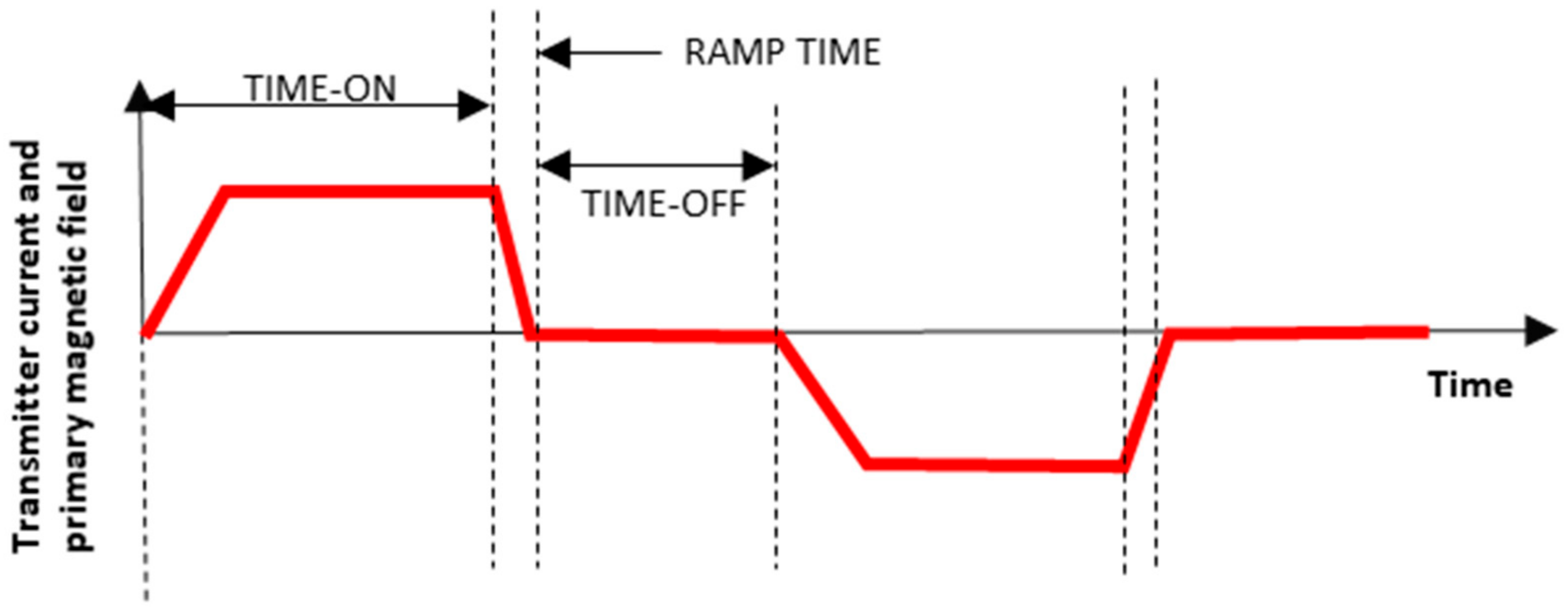
In more detail, the process of an electromagnetic survey would be as follows:
- 1.
A current is circulated through the transmitting loop (Tx), which creates a time-varying primary magnetic field (
Figure 5).
- 2.
According to Faraday’s law, a rapid decrease of the transmitted current and thus of the primary magnetic field induces an electromotive force (emf.) in the subsurface (
Figure 6).
- 3.
These induced currents generate, in turn, a secondary magnetic field whose variation over time is measured in the receiving coil (Rx) (
Figure 7).
6. Results from Time-Domain Electromagnetic Surveys
An electromagnetic profile was carried out in a N-S direction, in the direction of the presumed dominant geological structure in the area, starting at the Triassic facies and ending at the Cretaceous terms. The length of the profile was 3200 m, and it was produced from the execution of a total of five TDEM surveys. To place the TDEM’s 100 × 100 loops accurately, a compass Silva SSM360LA Professional Optical Compass was used. This is a high-precision and high-sensitivity compass with sapphire bearings and quick position adjustment.
The TDEM surveys were carried out using the Terra-Tem equipment (
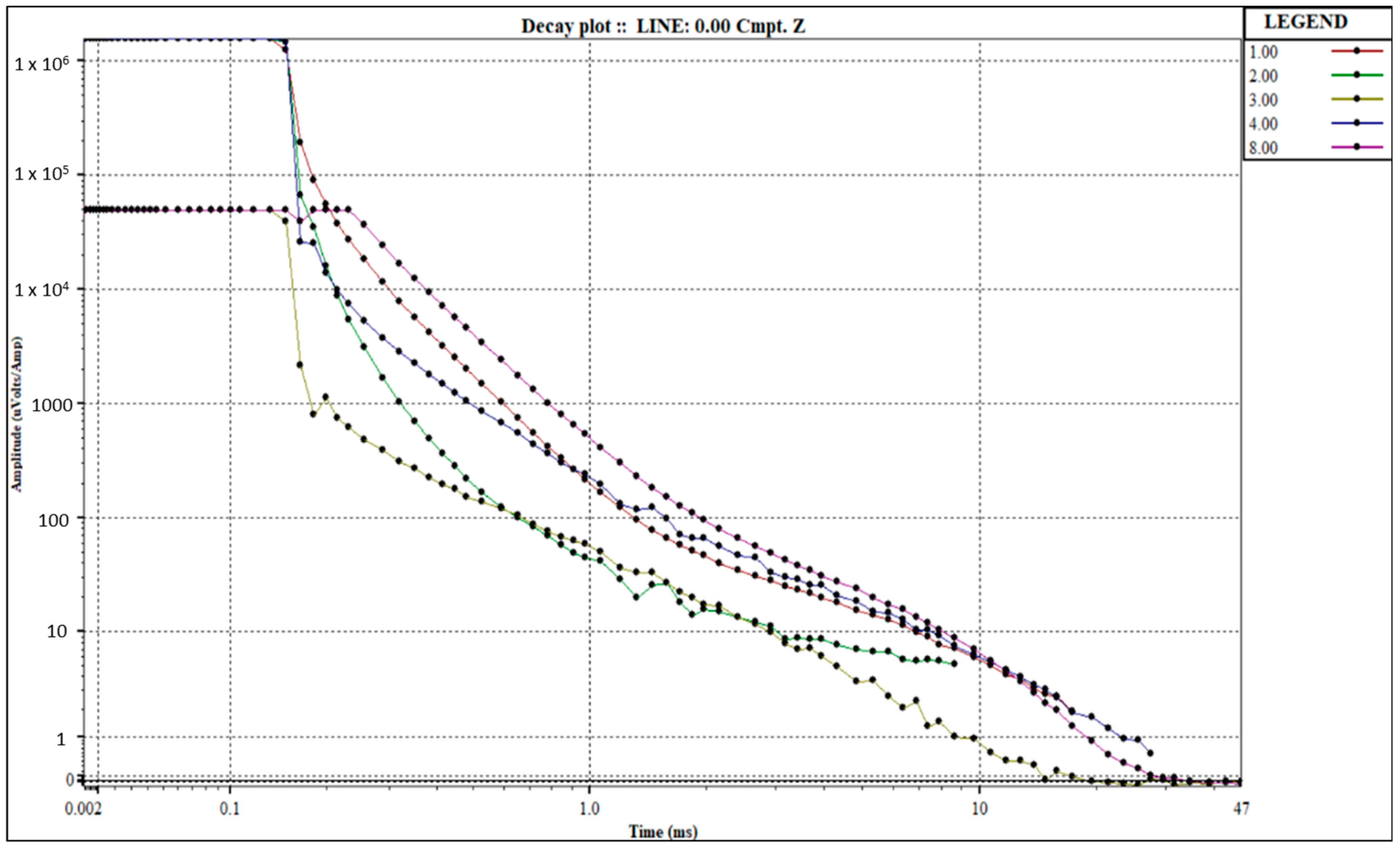
Figure 8) designed by Monex GeoScope, with a “coincident loop” configuration and with square loops (transmitter and receiver) of 100 m on each side, using a minimum stacking of 1000 measurement repetitions per channel and testing various gains to minimise the effect of any environmental electromagnetic noise. The results of the different decay curves obtained in the field are shown using the Terratem equipment software “TEM Plotting Program v 2.0.0” from Monex GeoScope (
Figure 9).
After the measurements, the resistivity/time curves were obtained and processed using the IX1D software from Interpex to obtain the geoelectric resistivity/depth column for each TDEM survey carried out (
Figure 10). These data were used, also through the IX1D software, to obtain a geoelectric profile, through which a geological and hydrogeological interpretation of the studied area could be made.
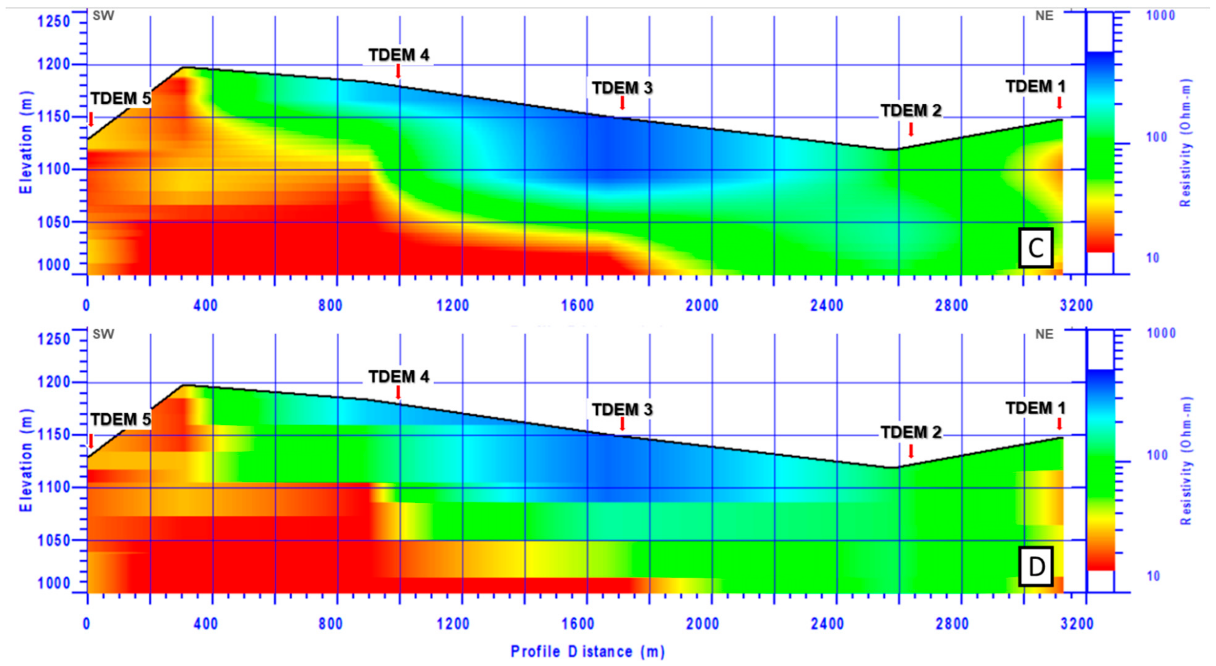
We chose Occam inversion [
24] on this occasion for its greater simplicity and softness when comparing the geological profile. The profile obtained (
Figure 11) identified the presence of a total of three geoelectric units:
Geoelectric Unit 1: present at the SW end of the profile, is of a conductive nature, with resistivities below 30 Ohm.m, corresponding to Triassic materials (shales, gypsum and sandstones). The low resistivities of this unit may be influenced by the low hydrochemical quality.
Geoelectric Unit 2: corresponding to the Finitriassic and Jurassic carbonate resistive materials (limestones and dolomites). This is a unit located on top of the previous one, appearing between metres 400 and 2600 of the profile, with more than 140 m of thickness. The high resistivities of this unit (100–500 Ohm.m) indicate a high proportion of permeable materials (limestones and dolomites) compared to impermeable materials (marls and marl-limestones). In addition, high resistivities are usually indicative of the good chemical quality of the groundwater.
Geoelectric Unit 3: appears around metre 2600 of the profile and extends to the end of the profile. The unit shows a resistivity that is intermediate to the previous ones and corresponds to Cretaceous materials (sands, marls, marlstones and limestones).
The general structure observed, according to the geophysical data, is concordant with the geologically predefined one, in which the Mesozoic sequence appears normal in character, dipping slightly, about 15 degrees to the northeast, with all the terms of the series progressively outcropping in that direction.
7. Discussion
The geophysical profile obtained shows concordance (
Figure 11) with the available geological information (Geological Map of Spain 1:50,000, sheet n° 404 Ayllón); as an improvement, it allows us to define the position and depth of the materials belonging to the three existing geological (Cretaceous, Jurassic and Triassic) and geoelectric formations. This has been possible thanks to the important resistivity contrast among the Mesozoic formations. However, other geological contexts present geoelectrical similarities that do not allow the efficient use of this TDEM technique for hydrogeological purposes.
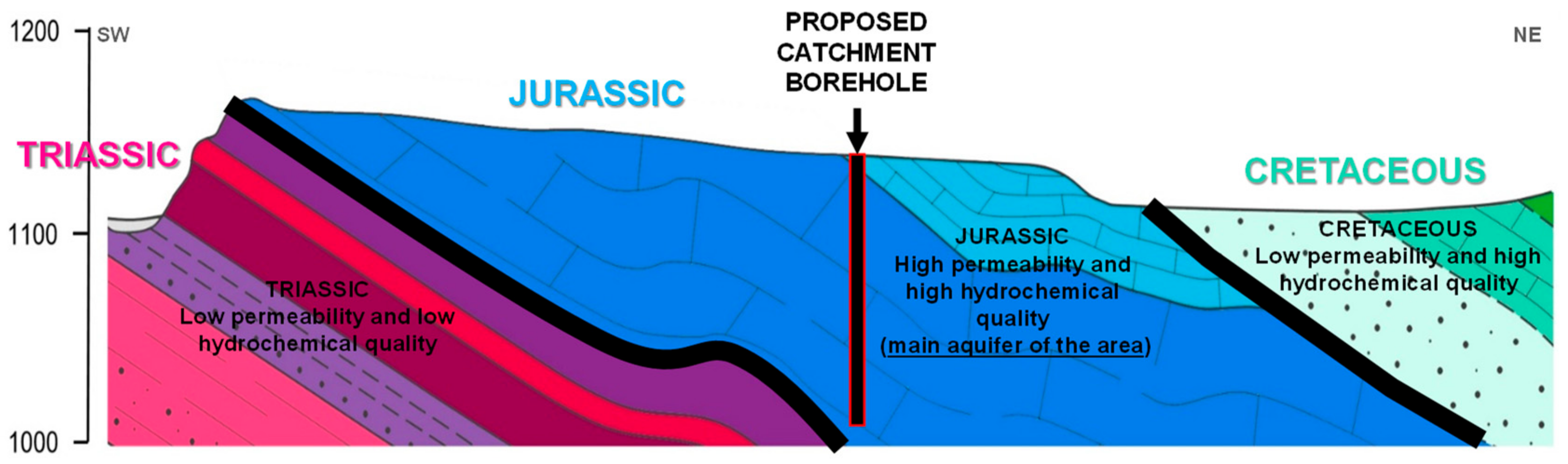
In this case, the target formation of the catchment, corresponding to geoelectric unit number two of a resistive nature, and formed by Finitriassic and Jurassic limestones and dolomites, is the main aquifer of the area, corresponding to the “Infralías” and “Lías” of the Iberian Mountain Range (Cordillera Ibérica). The high resistivities of this unit indicate a high proportion of permeable materials (limestones and dolomites) and a high hydrochemical quality of the groundwater. This aquifer has sections of variable permeability due to fissuring and/or karstification, and it behaves as a free aquifer. This geoelectric unit has an approximate thickness of about 140 m, dipping slightly to the northeast, with an apparent dip of about 15 degrees. Given that the catchment should be located in the place where it reaches the greatest possible depth within the profile under study, it is recommended that it be carried out at around metre 2000 of the profile, with an approximate depth of 140 m.
On the other hand, it is important to avoid the geoelectric unit number one, associated with the poor known hydrogeological characteristics of the Triassic materials (low hydrochemical quality and insufficient flow). Triassic materials are the low permeability substrate with the contribution of substances of an evaporitic nature that particularly influence the quality of the resource. Therefore, the objective is to drill the maximum possible thickness of saturated Jurassic materials without touching the Triassic materials (
Figure 12).
Drilling in the final part of the profile could also be considered so that the Cretaceous and Jurassic materials are crossed, which would allow the permeable sections of the entire cross-section to be captured, allowing for higher flow rates. However, this option is discarded, in view of the results of the geoelectric study, on observing the poor prospects obtained by TDEM 1, in which the Cretaceous materials showed relatively conductive values related to the presence of predominantly loamy materials as a whole, with lower prospects from the hydrogeological point of view. This would require, at the same time, much deeper and more costly drilling, both in execution and exploitation, to capture resources in the Jurassic materials (geoelectric unit number two).
8. Conclusions
The geophysical study carried out by means of TDEM sounding in Liceras (Soria, Spain) demonstrates the value of this geophysical research system as a support for hydrogeological studies in Mesozoic formations. The difference in resistivity of the Cretaceous, Jurassic and Triassic formations allows for obtaining geoelectric profiles that can be correlated with the local and regional geological and hydrogeological structure, which allows for the definition of the structure and position in the subsurface of the Mesozoic sequence outcropping in the study area. In addition, the low resistivities could indicate a low hydrochemical quality of the groundwater, usually associated with the gypsum of the Triassic formation.
This spatial information obtained by Time-Domain Electromagnetic is essential when considering the design of works to capture hydrogeological Mesozoic resources in order to solve the quality and supply problems existing in the area, as it defines the ideal location and depth for the execution of potential works.
Therefore, combining the pre-existing geological data with TDEM geophysical data has shown to be a methodology that can solve similar problems in Mesozoic formations and can produce savings for both public and private institutions in their investment in hydrogeological resources.


 ,
, 


