
Simplified Expansions of Common Latitudes with Geodetic Latitude and Geocentric Latitude as Variables


Abstract
:
1. Introduction
2. Generation and Definition of Third Flattening
3. Common Latitude Power Series Expansions with Geodetic Latitude as Variable
3.1. Power Series Expansion of Rectifying Latitude with Geodetic Latitude as Variable
3.2. Power Series Expansion of Authalic Latitude with Geodetic Latitude as Variable
3.3. Power Series Expansion of Conformal Latitude with Geodetic Latitude as Variable
3.4. Power Series Expansion of Reduced Latitude with Geodetic Latitude as Variable
3.5. Power Series Expansion of Geocentric Latitude with Geodetic Latitude as Variable
4. Common Latitude Power Series Expansions with Geocentric Latitude as Variable
4.1. Power Series Expansion of Authalic Latitude with Geocentric Latitude as Variable
4.2. Power Series Expansion of Rectifying Latitude with Geocentric Latitude as Variable
4.3. Power Series Expansion of Conformal Latitude with Geocentric Latitude as Variable
4.4. Power Series Expansion of Reduced Latitude with Geocentric Latitude as Variable
4.5. Power Series Expansion of Geodetic Latitude with Geocentric Latitude as Variable
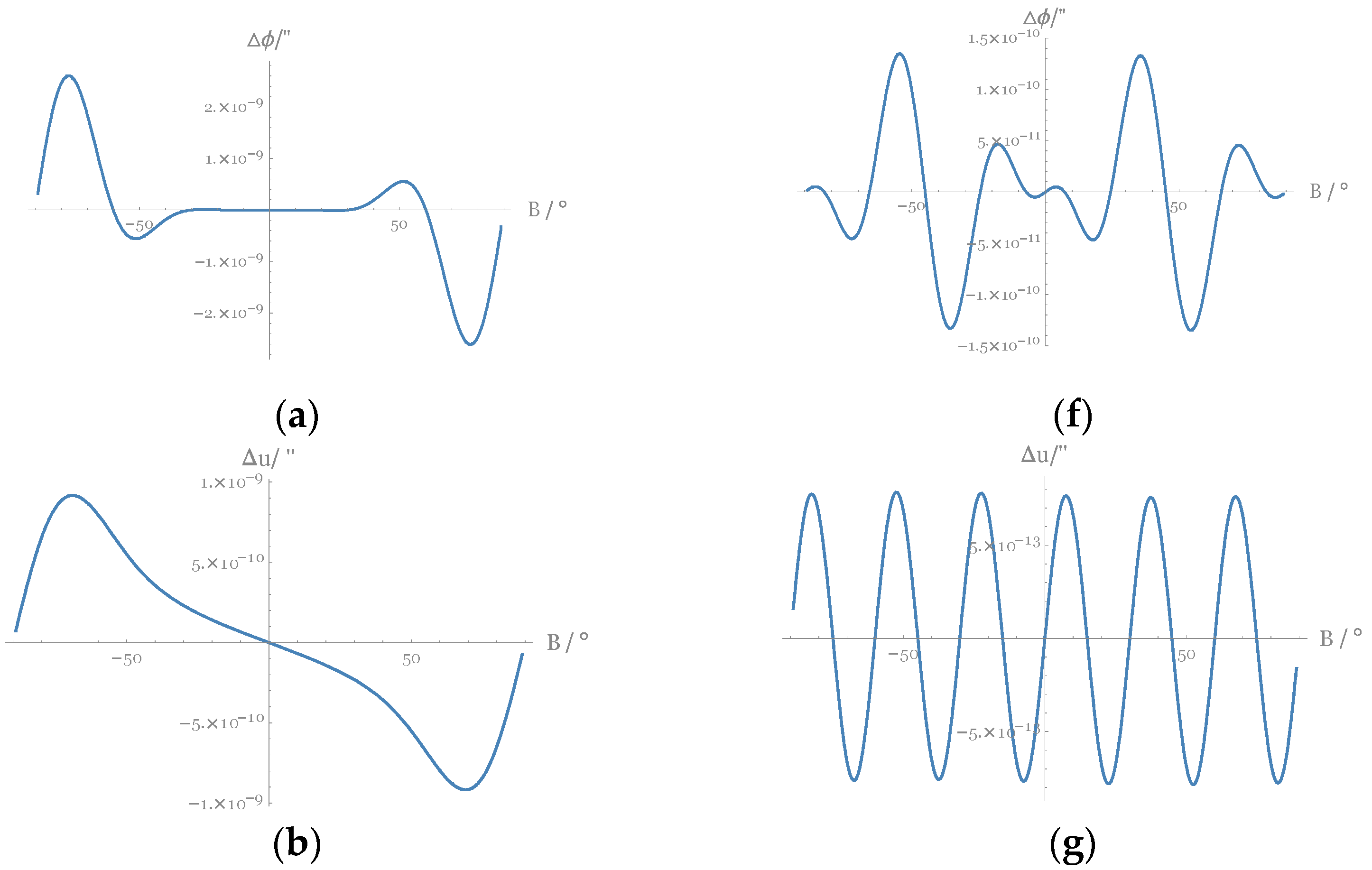
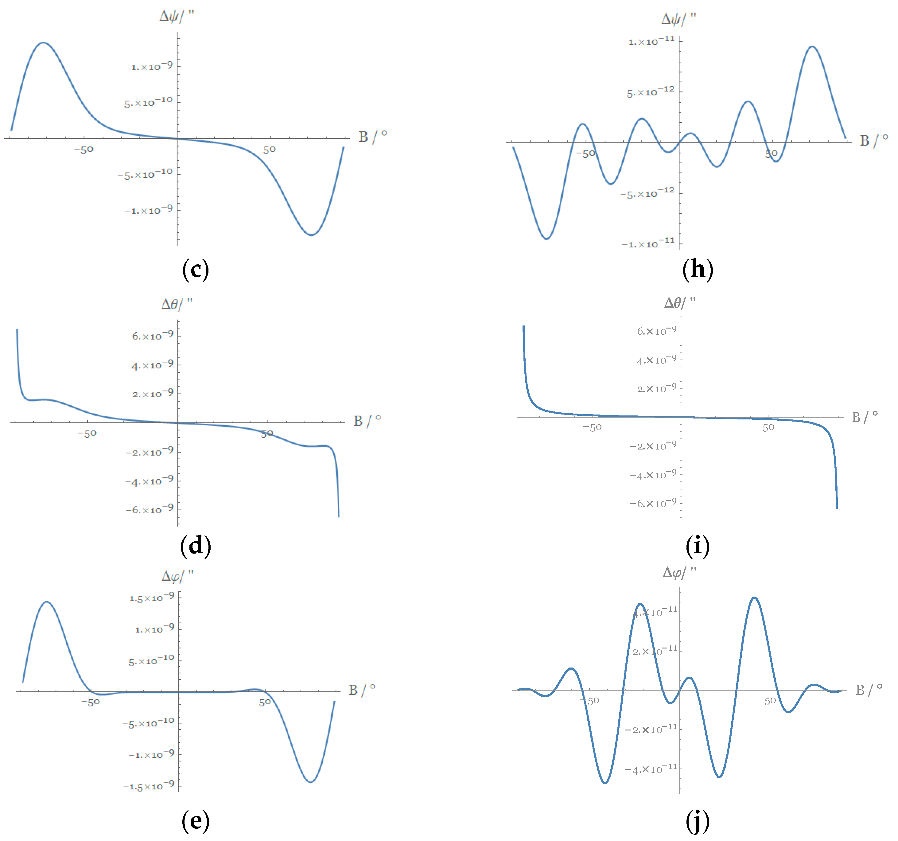
5. Truncation Error and Accuracy Analysis
6. Conclusions
- (1)
- The common latitude direct expansions with geocentric latitude as the variable are derived, and the power series expansions based on the ellipsoidal eccentricity and the third flattening are carried out, which extend map projection theory.
- (2)
- Compared with the power series expansions based on ellipsoid eccentricity , the power series expansions based on the ellipsoid third flattening are neater and more compact, and the coefficients are simpler. In addition, they converge better and are more accurate. This shows that the third flattening is superior to the ellipsoidal eccentricity in the coefficient expansion of common latitude expressions.
- (3)
- As the order of the power series expansions decreases, the expressions become simpler, but the corresponding truncation error increases. By analyzing truncation errors of different orders, we conclude that when the common latitude formulas are expanded to based on ellipsoidal eccentricity or expanded to based on the third flattening , they not only satisfy the precision required by geodesy but also make the expression more concise.
Author Contributions
Funding
Institutional Review Board Statement
Informed Consent Statement
Data Availability Statement
Acknowledgments
Conflicts of Interest
References
- Moore, T. Datums and Map Projections: For Remote Sensing, GIS and Surveying. Photogramm. Rec. 2009, 24, 128. [Google Scholar] [CrossRef]
- Blaschke, T. Object based image analysis for remote sensing. ISPRS J. Photogramm. 2010, 65, 2–16. [Google Scholar] [CrossRef] [Green Version]
- Grafarend, E.W.; You, R.-J.; Syffus, R. Map Projections; Springer: Berlin/Heidelberg, Germany, 2014. [Google Scholar]
- Lapon, L.; Ooms, K.; Maeyer, P.D. The Influence of Map Projections on People’s Global-Scale Cognitive Map: A Worldwide Study. Int. J. Geo Inf. 2020, 9, 196. [Google Scholar] [CrossRef] [Green Version]
- Su, K.; Jin, S.; Jiao, G. Assessment of multi-frequency GNSS PPP models using GPS, Beidou, GLONASS, Galileo and QZSS. Meas. Sci. Technol. 2020, 31, 064008. [Google Scholar] [CrossRef]
- Synder, J.P. Emergence of Map Projections from Flattening the Earth: Two Thousand Years of Map Projections; John Wiley & Sons, Ltd: Hoboken, NJ, USA, 2011. [Google Scholar]
- Iliffe, J.; Lott, R. Datums and Map Projections: For Remote Sensing, GIS and Surveying, 2nd ed.; CRC Press: Boca Raton, FL, USA, 2008. [Google Scholar]
- Karney, C.F.F. Transverse Mercator with an accuracy of a few nanometers. J. Geod. 2011, 85, 475–485. [Google Scholar] [CrossRef] [Green Version]
- Jenny, B.; Avri, B.; Arnold, N.D. A Guide to Selecting Map Projections for World and Hemisphere Maps; Springer International Publishing: Cham, Switzerland, 2017. [Google Scholar]
- Vermeille, H. Computing geodetic coordinates from geocentric coordinates. J. Geod. 2004, 94, 78. [Google Scholar] [CrossRef]
- Berthoud, M.G. An equal-area map projection for irregular objects. Icarus 2005, 382, 175. [Google Scholar] [CrossRef]
- Savric, B.; Jenny, B. Automating the selection of standard parallels for conic map projections. Comput. Geosci. 2016, 90, 202–212. [Google Scholar] [CrossRef]
- Yang, Q.; Snyder, J.; Tobler, W. Map Projection Transformation: Principles and Applications; Taylor and Francis Publication: Milton Park, UK, 2020. [Google Scholar]
- Adams, O.S. Latitude Developments Connected with Geodesy and Cartography; United States Government Printing Office: Washington, DC, USA, 1949. [Google Scholar]
- Bian, S.; Li, H. Mathematical analysis in cartography by means of computer algebra system. In Cartography: A Tool for Spatial Analysis; Bateira, C., Ed.; IntechOpen: Rijeka, Croatia, 2012. [Google Scholar]
- Bian, S.; Li, H. Complex Function Representation of Gaussian Projection; Science Press: Beijing, China, 2021. [Google Scholar]
- Jiao, C.; Li, H.; Bian, S.; Zhong, Y.; Pan, X. Symbolical expressions for direct and inverse solutions of common latitudes with the variable of geocentric latitude. Geom. Inf. Sci. Wuhan 2021, 47, 707–714. [Google Scholar] [CrossRef]
- Ye, T.; Li, H.; Zhong, Y.; Pan, X. Symbolic expressions of difference between auxiliary and reduced latitudes. Geom. Inf. Sci. Wuhan 2022, 47, 473–480. [Google Scholar] [CrossRef]
- Li, H.; Bian, S. Derivation of inverse expansions for auxiliary latitudes by hermite interpolation method. Geom. Inf. Sci. Wuhan 2008, 6, 623–626. [Google Scholar]
- Li, H.; Bian, S.; Liu, M. Direct expansions of transformations between three kinds of latitudes used in map projection. Geom. Inf. Sci Wuhan 2013, 38, 17–220. [Google Scholar]
- Zong, J.; Li, H.; Bian, S.; Tang, Q. Symbolic Expressions of Differences between Earth Radius. Acta Geod. Cartogr. Sin. 2019, 48, 238–244. [Google Scholar]
- Vermeille, H. Direct transformation from geocentric coordinates to geodetic coordinates. J. Geod. 2002, 451, 76. [Google Scholar] [CrossRef]
- Molčíková, S.; Hurčíková, V.; Blištan, P. Advances and Trends in Geodesy, Cartography and Geoinformatics II. In Proceedings of the 11th International Scientific and Professional Conference on Geodesy, Cartography and Geoinformatics (GCG 2019), Demänovská Dolina, Low Tatras, Slovakia, 10–13 September 2019; CRC Press: Boca Raton, FL, USA, 2020. [Google Scholar]
- Awange, D. Solving Algebraic Computational Problems in Geodesy and Geoinformatics; Springer: Berlin/Heidelberg, Germany, 2005. [Google Scholar]
- Zong, J. Symbolic expressions of differences between Earth radii. Acta Geod. Cartogr. Sin. 2019, 3, 45. [Google Scholar]
- Chen, J. Chinese modern geodetic datum—Chinese geodetic coordinate system 2000 (CGCS 2000) and its frame. Acta Geod. Cartogr. Sin. 2008, 269, 37. [Google Scholar]
- Li, Z. Space Geodesy; Wuhan University Press: Wuhan, China, 2010. [Google Scholar]
- Hua, T.; Ding, J.; Bian, S.; Li, H. Projection of Map Charts; Xi’an Map Publishing House: Xi’an, China, 2018. [Google Scholar]
- Bermejo-Solera, M.; Otero, J. Simple and highly accurate formulas for the computation of transverse mercator coordinates from longitude and isometric latitude. J. Geod. 2009, 83, 1–12. [Google Scholar] [CrossRef]
- Guo, J.; Zhao, X.; Xu, X. Calculating meridian arc length by transforming its formulae into elliptic integral of second kind. Geod. Geodyn. 2011, 31, 94–98. [Google Scholar]
- Lv, X.; Li, S. Principles and Methods of Map Projection; Publishing House of Surveying and Mapping: Beijing, China, 2016. [Google Scholar]
- Hooijberg, M. Geometrical Geodesy; Springer: Berlin/Heidelberg, Germany, 2008. [Google Scholar]


| Expand to e10 Based on the First Eccentricity e | Expand to n5 Based on the Third Flattening n |
|---|---|
| Expand to e10 Based on the First Eccentricity e | Expand to n5 Based on the Third Flattening n |
|---|---|
| Expand to e10 Based on the First Eccentricity e | Expand to n5 Based on the Third Flattening n |
| Expand to e10 Based on the First Eccentricity e | Expand to n5 Based on the Third Flattening n |
|---|---|
| Expand to e10 Based on the First Eccentricity e | Expand to n5 Based on the Third Flattening n |
|---|---|
| Expand to e10 Based on the First Eccentricity e | Expand to n5 Based on the Third Flattening n |
|---|---|
| Expand to e10 Based on the First Eccentricity e | Expand to n5 Based on the Third Flattening n |
|---|---|
| Expand to e10 Based on the First Eccentricity e | Expand to n5 Based on the Third Flattening n |
|---|---|
| Expand to e10 Based on the First Eccentricity e | Expand to n5 Based on the Third Flattening n |
|---|---|
| Expand to e10 Based on the First Eccentricity e | Expand to n5 Based on the Third Flattening n |
|---|---|
| 2.56114 × 10⁻⁹ | 9.31323 × 10⁻¹⁰ | 1.42609 × 10⁻⁹ | 1.76893 × 10⁻⁸ | 1.45519 × 10⁻⁹ | |
| 4.52972 × 10⁻⁸ | 1.63272 × 10⁻⁷ | 2.44094 × 10⁻⁷ | 2.2928 × 10⁻⁷ | 2.65311 × 10⁻⁷ | |
| 8.10159 × 10⁻⁵ | 3.01542 × 10⁻⁵ | 4.58977 × 10⁻⁵ | 4.24962 × 10⁻⁵ | 1.47941 × 10⁻⁶ | |
| 0.0151037 | 0.00590163 | 0.00913985 | 0.00833335 | 0.0107551 | |
| 1.60071 × 10⁻¹⁰ | 1.16415 × 10⁻¹⁰ | 1.16415 × 10⁻¹⁰ | 1.76369 × 10⁻⁸ | 1.45519 × 10⁻¹⁰ | |
| 4.51109 × 10⁻⁸ | 6.1118 × 10⁻¹⁰ | 2.76486 × 10⁻⁹ | 1.27475 × 10⁻⁸ | 2.08966 × 10⁻⁸ | |
| 1.15433 × 10⁻⁵ | 4.10277 × 10⁻⁷ | 1.58537 × 10⁻⁶ | 1.11121 × 10⁻⁶ | 8.84886 × 10⁻⁶ | |
| 0.00455778 | 0.000325557 | 0.00126153 | 0.000803024 | 0.00312175 |
| 2.61934 × 10⁻⁹ | 9.31323 × 10⁻¹⁰ | 9.74978 × 10⁻¹⁰ | 9.02219 × 10⁻¹⁰ | 1.01863 × 10⁻⁹ | |
| 4.53001 × 10⁻⁷ | 1.63243 × 10⁻⁷ | 1.42056 × 10⁻⁷ | 1.35537 × 10⁻⁷ | 1.56637 × 10⁻⁷ | |
| 8.10159 × 10⁻⁵ | 3.01542 × 10⁻⁵ | 2.25394 × 10⁻⁵ | 2.19159 × 10⁻⁵ | 2.53659 × 10⁻⁵ | |
| 0.0151037 | 0.00590163 | 0.0035465 | 0.00367417 | 0.00392772 | |
| 1.89175 × 10⁻¹⁰ | 1.16415 × 10⁻¹⁰ | 1.74623 × 10⁻¹⁰ | 1.16415 × 10⁻¹⁰ | 1.74623 × 10⁻¹⁰ | |
| 4.52274 × 10⁻⁸ | 6.40284 × 10⁻¹⁰ | 7.01402 × 10⁻⁹ | 6.72298 × 10⁻⁹ | 5.52973 × 10⁻⁹ | |
| 1.15434 × 10⁻⁵ | 4.0984 × 10⁻⁷ | 2.18944 × 10⁻⁶ | 2.0791 × 10⁻⁶ | 2.29341 × 10⁻⁶ | |
| 0.00455778 | 0.000325912 | 0.00109875 | 0.000766065 | 0.00107432 |
Publisher’s Note: MDPI stays neutral with regard to jurisdictional claims in published maps and institutional affiliations. |
© 2022 by the authors. Licensee MDPI, Basel, Switzerland. This article is an open access article distributed under the terms and conditions of the Creative Commons Attribution (CC BY) license (https://creativecommons.org/licenses/by/4.0/).
Share and Cite
Li, X.; Li, H.; Liu, G.; Bian, S.; Jiao, C. Simplified Expansions of Common Latitudes with Geodetic Latitude and Geocentric Latitude as Variables. Appl. Sci. 2022, 12, 7818. https://doi.org/10.3390/app12157818
Li X, Li H, Liu G, Bian S, Jiao C. Simplified Expansions of Common Latitudes with Geodetic Latitude and Geocentric Latitude as Variables. Applied Sciences. 2022; 12(15):7818. https://doi.org/10.3390/app12157818
Chicago/Turabian StyleLi, Xiaoyong, Houpu Li, Guohui Liu, Shaofeng Bian, and Chenchen Jiao. 2022. "Simplified Expansions of Common Latitudes with Geodetic Latitude and Geocentric Latitude as Variables" Applied Sciences 12, no. 15: 7818. https://doi.org/10.3390/app12157818
APA StyleLi, X., Li, H., Liu, G., Bian, S., & Jiao, C. (2022). Simplified Expansions of Common Latitudes with Geodetic Latitude and Geocentric Latitude as Variables. Applied Sciences, 12(15), 7818. https://doi.org/10.3390/app12157818