Article

A Practical Approach to Deploying a Drone-Based Message Ferry in a Disaster Situation †

Wave Engineering Laboratories, Advanced Telecommunications Research Institute International, Kyoto 619-0228, Japan
*
Author to whom correspondence should be addressed.
This material was presented in part at the ICT-DM 2021 conference, Hangzhou, China, 3–5 December 2021.
These authors contributed equally to this work.
Appl. Sci. 2022, 12(13), 6547; https://doi.org/10.3390/app12136547
Submission received: 29 April 2022 / Revised: 17 June 2022 / Accepted: 24 June 2022 / Published: 28 June 2022

Abstract

:
Unmanned aerial vehicles (UAVs) are commonly used in disaster recovery efforts to confirm the extent of the damage caused by a large-scale disaster and to ensure that adequate information about the affected area is gathered. UAV usage in a disaster situation is not limited to information gathering, but its functions further extend to network communication functions such as a communication relay, mobile base station, etc. Conversely, using UAVs as communication relays or base stations (e.g., as a temporary mobile base station) is subject to some limitations such as bad weather and limited energy, which affect the timely collection and delivery of information to and from a disaster area. Therefore, an approach to improve the information collection and delivery in a disaster area while ensuring urgent network restoration is necessary. In this paper, we introduce a practical approach to deploying a drone-based message ferry to improve the timely collection and delivery of information in a disaster situation. Specifically, a locally accessible cloud system (LACS), which we previously developed for urgent local network restoration in a disaster affected area, is attached to a drone to form a message ferry. In order to improve the information collection and delivery, the message ferry is deployed from the local headquarters (i.e., local government office or disaster response coordination center) to carry information to and from a standalone LACS installed at each disaster shelter. We measure the achievable data rate of inter-LACS data transfer (i.e., message ferry and a standalone LACS) through experiment. Thereafter, we estimate and confirm the effective transmission speed to transfer data from the local headquarters to the disaster shelters using average achievable data rate obtained from the experiment in order to extend the LACS services and functions. Our experimental results and analysis suggest that the proposed message ferry is more advantageous to transfer a large amount of data (e.g., 300 MB) at a high speed in the hundred meter to ten kilometer range.

1. Introduction

The importance of an unmanned aerial vehicle (UAV) for ICT solutions in providing access to vital information during and in the aftermath of a large-scale disaster cannot be over-emphasized. The use of UAVs is crucial to the disaster management and recovery efforts [1] to ensure adequate safety and prevent loss of life that may be caused by various disasters like earthquakes, typhoons, landslides, and wildfires. When a large-scale disaster occurs, the communication infrastructure is destroyed and the pace of disaster response is often affected due to lack of correct and up-to-date information, which may lead to delays and decision errors. In this instance, the traditional approach that is often used to restore communication is to change the damaged network components with new ones or provide a container type network node as a substitute [2]. Nevertheless, the optical fiber and fixed wireless link that is essential for such a system needs a substantial amount of installation time and in some instances physical installation is not possible in the disaster area. Moreover, previous studies utilized a mobile ad-hoc network (MANET) [3], although users need to be in constant connection with one another in order to be able to share vital information. Furthermore, a delay tolerant network (DTN) [4] is used when a steady network connection is difficult to establish when there is a communication failure, which is often experienced in the aftermath of a large-scale disaster. In the DTN, messages are stored by users and when in close proximity with other users, the stored messages can be forwarded. This is commonly referred to as a store-and-carry forward method.
Furthermore, extensive applications of UAV as a communication relay in delay tolerant and ad-hoc networks have been studied. For example, Refs. [5,6] proposed the use of mobile base station and UAV as an aerial base station to ensure that people in a disaster area can communicate with their families within and outside the affected area. However, utilizing UAV as a temporary base station in the aftermath of a large-scale disaster has some limitations [7]. One such limitation is the excessive calls from people trying to communicate with their relatives. These excessive calls lead to network congestion due to the increase in network traffic. It has been confirmed in the past that the network traffic during a large-scale disaster increased 60 times with respect to the average network traffic [8,9]. Additionally, the operation of the UAV as a base station is subject to other limitations like poor weather conditions, complex deployment logistics, and limited power supply [10].
In spite of numerous studies conducted on the use of UAV in disaster recovery efforts and various solutions proposed to resolve the challenges of accessing vital information after a large-scale disaster has occurred [11,12], accessing accurate and urgent information in real-time in a disaster area is still a major challenge. Furthermore, the decision-making for a timely disaster response is also affected as a result of the real-time information synchronization issue [13] that may be caused by MANET’s constraint [14], e.g., intermittent connection failure, network congestion, limited network or device resources, security and information integrity. Hence, a method that can be used to collect and provide critical information in a timely manner is needed to enhance disaster response and management.
Previously, we proposed an improved approach for realizing the timely and efficient collection and delivery of disaster information based on the Locally Accessible Cloud System (LACS) (described briefly in Section 2.3) [15] to urgently restore and/or deploy ICT environment locally in the disaster area [16,17]. Specifically, LACS is installed in the evacuation shelters to reestablish the network communication and provide a means for people to communicate locally after a disaster has occurred and the communication infrastructure is destroyed. Thereafter, a vehicle mounted with LACS (referred to as movable LACS hereafter) deploy from the local headquarters (i.e., local government office or disaster response coordination center) tours each shelter to collect/deliver vital information from/to the evacuees. In addition, when the LACS installed in the shelter and the movable LACS establish a network connection, data can be synchronized automatically between the two LACSs using the synchronization function implemented on LACS. The synchronized information on the local LACS can be accessed by the evacuees. However, the service area covered by a LACS is limited to about hundred meters in radius due to the Wi-Fi characteristics and it may hamper the efforts to collect and deliver accurate information. To increase the coverage distance of the movable LACS in a timely manner, it is necessary to consider an alternative approach that can be used to improve the information collection and delivery in a disaster affected area.
This paper proposes a practical approach to deploying a drone-based message ferry that can be utilized in collecting and delivering disaster information after a disaster has occurred. To create a message ferry in our proposal, LACS is attached to a drone (i.e., the physical LACS device is attached to the drone). LACS has a storage and communication functions which are combined with the drone function to form the message ferry. The communication of the message ferry is based on LACS Wi-Fi. After a large-scale disaster has occurred, the message ferry is deployed from the local headquarters (i.e., local government office or disaster response coordinator center) for collecting/delivery of vital information from/to the people in the disaster shelters (i.e., the message ferry flies autonomously to the disaster shelters after deployment). The message ferry also utilizes the LACS synchronization function to communicate with other LACS in close proximity, this allows the message ferry to serve as a link for plural LACSs. The goal of our proposed message ferry is to ensure that there is an urgent restoration of network function and/or to deploy an ICT environment locally while extending the service coverage of LACS. This can be more advantageous in collecting and delivering urgent and vital information in the disaster area. Unlike in previous research [18,19,20,21], the proposed message ferry not only introduced the concept of using drones to carry messages from one location to another. It also focused on the practicality and the actual application and usage of the concept in a real life scenario (i.e., disaster situation). The main contributions of this study are summarized as follows.
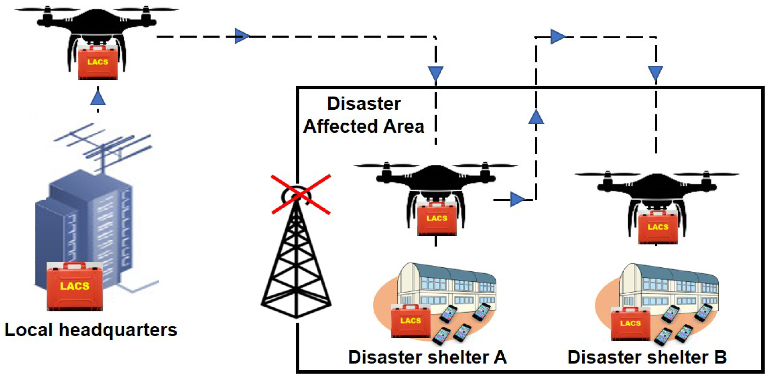
  • Firstly, we devise an approach to deploying a drone-based message ferry using LACS in the disaster affected areas in order to achieve urgent restoration of network function in a local context.
  • Secondly, we derive a method to analyze the effective transmission speed that the message ferry can achieve in order to extend the LACS-based service area in a disaster situation.
  • Furthermore, we analyze and confirm the effective transmission speed that is useful in transferring data of various sizes when the message ferry is utilized to transfer data from the local headquarters to each disaster shelter.
  • Finally, we evaluate the performance of the proposed message ferry by conducting an experiment. In the experimentation, we use the LACS prototype and measure the inter-LACS data transfer rate. The measured data transfer rate is utilized to confirm the effective transmission speed of the message ferry in a disaster situation.
The results show the overall average inter-LACS data transfer rate for a data size of 1 MB, 5 MB, 10 MB, 50 MB, 100 MB and 300 MB and an achievable overall average data transfer rate of 4 Mbps, 14 Mbps, for 802.11 b, g, on a frequency band of 2.4 GHz. In contrast, an overall average of 23 Mbps, 68 Mbps, and 141 Mbps is achievable for 802.11 a, n, ac on the 5 GHz frequency band. In addition, it was confirmed that it is more advantageous to transfer large data size at high data rate. The proposed message ferry achieved a higher effective transmission speed when Wi-Fi IEEE 802.11 protocols are utilized to extend the LACS-based services in the disaster area compared to other technologies such as Wi-SUN [22] and LoRa [23]. An effective transmission speed of 1 Mbps, 1.8 Mbps, 2 Mbps, 2.2 Mbps, and 2.3 Mbps at a distance of 10 km on 802.11 b, 802.11 g, 802.11 a, 802.11 n, and 802.11 ac respectively compared to 25 kbps for Wi-SUN and 119 kbps for LoRa for the same distance.
The rest of this paper is organized as follows. Section 2 highlights the features, uses of LACS under various scenarios and presents the use of LACS in the system for collecting and delivering information. Section 3 outlines the proposed drone-based message ferry used to expand the coverage distance of the LACS-based service. In Section 4, we describe the performance evaluation of the proposed message ferry and the analysis of the coverage distance in a disaster affected area. Section 5 concludes the entire paper.

2. Overview of Locally Accessible Cloud System (LACS)

In this section, we first describe an overview of LACS, its features and uses. Subsequently, we explain in detail the use of LACS in a disaster response to collect and deliver vital information.

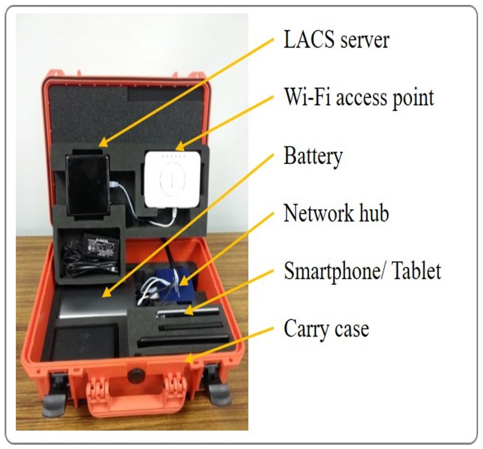
2.1. Locally Accessible Cloud System (LACS)

As part of our disaster response measures, we have created a LACS [16]. LACS enables people in a disaster area to communicate locally after a major disaster if the network is cut. LACS consists of a small server, a Wi-Fi access point, and a battery. LACS is able to provide cloud-based services at the local level, regardless of the situation. LACS offers a variety of service features such as information broadcasting, bulletin board, a social network service, instant messaging services, e.g., video conferencing, file sharing, and so on. Additionally, LACS can be used as a center for disseminating information in an area where the network is disconnected. In addition to using the LACS’s coordination function in disaster response systems, LACS can also be applied to other daily services like e-health, and e-education. The LACS prototype and its basic features are shown in Figure 1 and Figure 2.

2.2. Use-Cases of LACS

LACS is a multipurpose system which can be used to deliver various services in a variety of services in the event of a disaster and normal daily life. An example of the use of LACS in the event of a disaster is shown in Figure 3. A summary of LACS use-cases are provided below:
  • Disaster
    • Local Government—Broadcasting urgent and vital information to residents.
    • Disaster Shelter—Bulletin board, emergency inventory management, etc.
    • First Responders (e.g., firefighters, police, etc.)—Sharing and gathering information, etc.
  • Normal daily uses
    • Local Government—Disseminate critical and time-sensitive information to residents, equipment and inventory management system, etc.
    • School—Bulletin Board, record management, eLearning, etc.
    • Office—Temporary file storage, record management, information bulletin board, etc.
    • Residents’ Association—Bulletin board, housing records management, instant messaging service, etc.
    • First Responders (e.g., firefighters, police, etc.)—Installed in vehicle for sharing and gathering information, temporary storage and record management, etc.
Moreover, LACS is also capable of providing one of the key features of a cloud-based system. If deployed in the form of resource pooling, LACS can serve multiple consumers, regardless of the services required. To confirm the possibility of deploying such services, a demonstration test was performed as part of a feasibility study [24,25]. In the feasibility study, services such as e-education, tele-medicine solution, and other disaster relation scenarios were confirmed. In addition, the deployment of additional cloud-based system services and their features will be confirmed in a subsequent demonstration test. In comparison, LACS differs from an edge node because it is used as a local system and does not send its processed outputs to a central server like most edge nodes. However, as a result of the multipurpose use of LACS, it can be used as part of an Edge computing system [26] if it is connected to the internet.

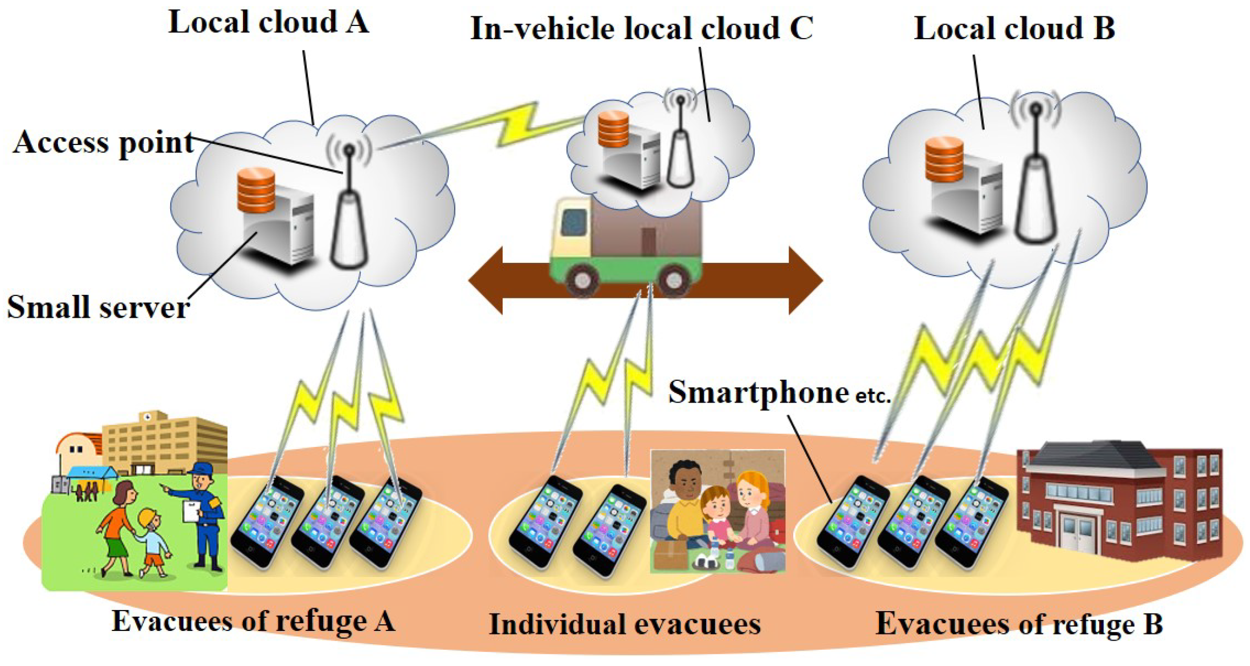
2.3. Information Delivery and Collection System Using LACS

Real-time information is essential for disaster response and planning. To ensure that there is an access to urgent and accurate information after a disaster has occurred and the network is cut off, we proposed a method to collect and deliver vital information using LACS in the past. As proposed in our previous work, two LACS deployment modes were considered. In these LACS deployment modes, LACS can be used as part of a central system such as the Shared Information Platform for Disaster Management (SIP4D) [27]).
In the first mode, LACS is installed only at the local headquarters. A movable LACS tours each disaster shelter that is without a network connection in order to collect and deliver vital information from/to the evacuees at the shelters. Figure 4 shows the first LACS deployment mode. Additionally, NerveNet [28] can be utilized as an alternative to the movable LACS. The movable LACS can be used to collect/deliver data in various formats and sizes such as text, images, audio files, videos, etc. For instance, a 10-min HD video recording of the damaged building, road, injured evacuees, etc., should be between 1.2 GB and 5 GB based on the resolution used [29]. In this mode, information delivery and collection time increased as the number of people evacuated to shelters increased.
In the traditional way, after a large-scale disaster, the disaster response team goes to the affected areas to find out the extent of the damage. Thereafter, the relevant information acquired during the visit is then passed on to the local headquarters to determine the measures to be taken. In this case, the information about the situation changes quickly and there is little time and resources to respond to the rate at which information changes. In recent times, this relevant information can be obtained by using various forms of communication infrastructure. However, most of the systems developed and used by many branches of government for disaster response depend heavily on internet connectivity [30]. In a situation where the communications infrastructure is severely damaged, the disaster response effort will be negatively impacted by the disconnection of the Internet. As a result, timely collection and delivery of information to individuals in the affected area may not be possible.
In the second LACS deployment mode, LACS is installed at the local headquarters and as a standalone system in each disaster shelter as shown in Figure 5. The standalone LACS is used by the evacuees in the shelter to access LACS services and features, such as the bulletin board, information sharing and viewing of damaged areas, etc. Furthermore, essential information can be uploaded by evacuees to the standalone LACS server, which will be collected by the movable LACS. Also, evacuees can communicate with each other using the instant messaging feature on the standalone LACS (i.e., without an Internet connection). Similar to the first deployment mode, a movable LACS from the local headquarters tours each disaster shelter in order to deliver and collect up-to-date information to/from the standalone LACS.
To improve the time it takes to collect and deliver information, the movable LACS and the standalone LACS after establishing a network connection, automatically synchronize data on the LACS servers. While synchronizing, the updated information to be delivered/collected transfers between both servers. Compared with the first deployment mode in which the movable LACS communicates directly with every evacuee, the second deployment mode is different in that only inter-LACS communication is established. This improves the time it takes for delivery and collection information. With this proposal, essential and urgent information required for an adequate disaster response can be efficiently collected and delivered. However, there may be situations where deploying a mobile LACS (i.e., a vehicle mounted with a LACS) can be challenging. Therefore, a drone-based message ferry is considered as an alternative approach.

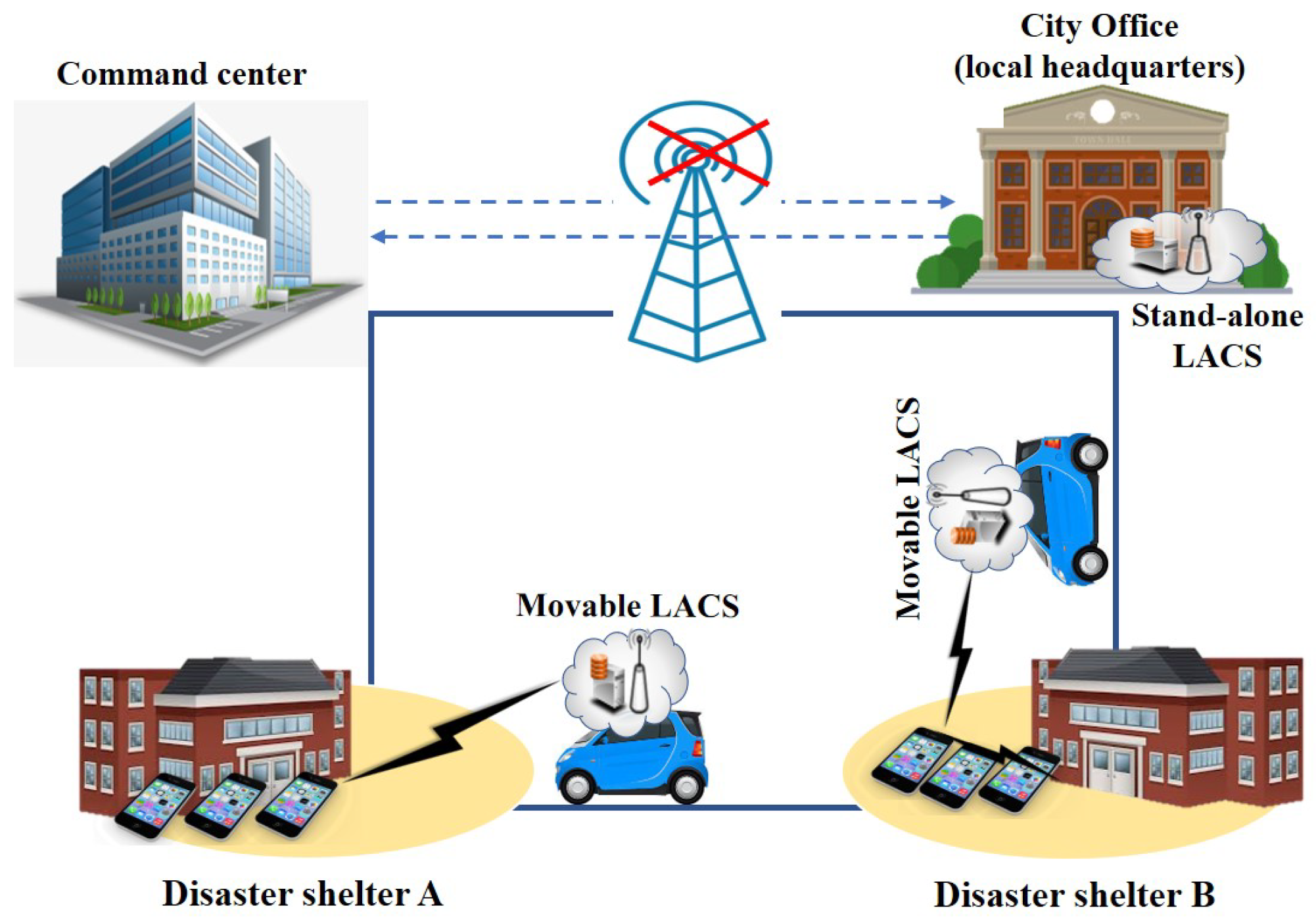
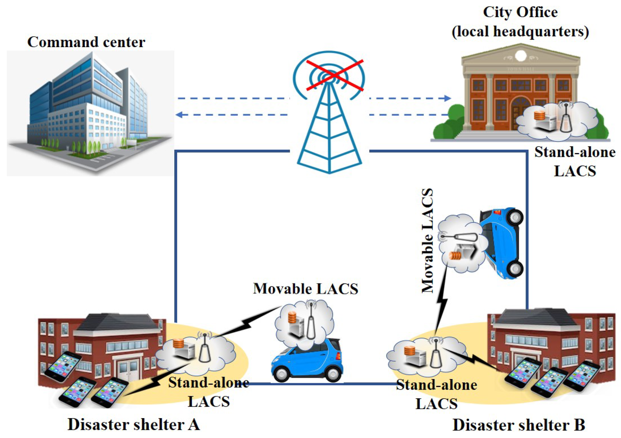
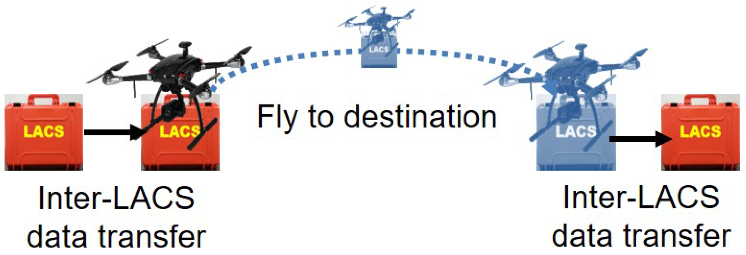
3. Proposed Drone-Based Message Ferry for LACS Network
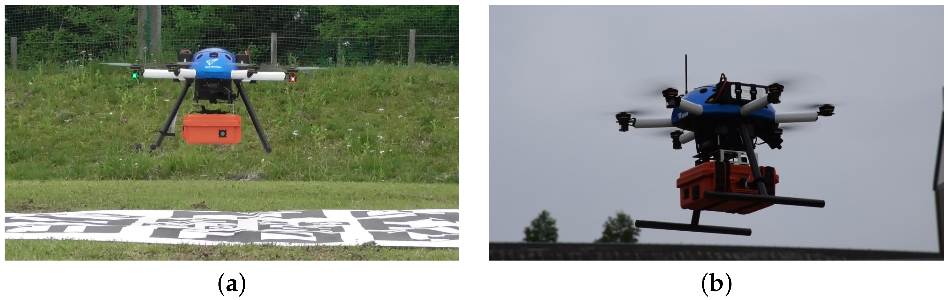
After a disaster that caused damage to the communications infrastructure, there is a critical need to restore it or deploy a substitute ICT network to meet the explosive demand for communication services in the disaster areas. To meet this issue, we proposed LACS as stated above. However, the service area covered by a LACS is limited to about hundred meters in radius at the maximum due to the Wi-Fi characteristics. This can hamper the information collection and delivery of disaster information which is needed for timely disaster recovery and management efforts. To extend the service area, we need ways to form a LACS network by linking plural LACSs distributed in the area. The links based on optical fibers and fixed-wireless-access links are possible candidates, but they need time and occasionally receive restrictions to be physically deployed in the disaster situations.
To enlarge the coverage of LACS-based service, we propose the using of a message ferry (i.e., LACS attached to a drone) or links to form the LACS-based network. As stated in Section 2.3, a standalone LACS is installed to each disaster shelter and local headquarters. In the aftermath of a disaster, the message ferry is deployed from the local headquarters to the disaster shelters to collect and deliver urgent and vital information that is useful in the disaster recovery and management as shown in Figure 6. The LACS attached to the drone acts as an information carrier. Using the storage and Wi-Fi functions of LACS, the message ferry has access to the ground based LACSs via wireless link. After deployment of the message ferry, the message ferry moves around each disaster shelter and collect/deliver information by performing inter-LACS data transfer between the LACS of the message ferry and the pre-deployed LACS (i.e., standalone LACS) at the disaster shelter. In addition, the message ferry utilized the LACS synchronization function to communicate with other LACS in close proximity. In this proposal, the message ferry acts as links in the LACS network, as shown in Figure 7.
In addition, the LACS’s battery can serve as a backup power supply to the message ferry in order to improve one of the constraints (i.e., limited amount of energy) identified in [10] as a hindrance to deploying UAV in a critical situation. This will allow the message ferry to land safely in a situation where the drone energy is depleted.
The proposed ferry is more advantageous than the current approach (i.e., using drones as a communication relay) in that more distance can be covered without pre-configuration of the network. In addition, with the proposed approach, the proposed message ferry can be utilized to effectively transfer large amount of data at a high speed compared to other wireless technologies such as Wi-SUN and LoRa as stated in [22,23,31,32]. Wi-SUN has a range of 5 km at up to 250 kbps while LoRa can cover up to 15 km at 50 kbps. In contrast, the proposed message ferry is expected to achieve LACS service coverage of 20 km at 1 Mbps. Therefore, the effective data transmission speed that the message ferry can achieve in such situation is analyzed at various coverage distances in our evaluation.
The LACS prototype is attached to a high performance drone (ACSL-PF2 model from Autonomous Control Systems Laboratory) [33] to form the proposed message ferry. Specifically, a PF2-delivery drone that is capable of performing an autonomous flight for safely transportation, logistics and home delivery was used. The drone has the following specifications: total length = 1173 mm, height = 526 mm excluding the antenna, flight speed = 10 m/s (horizontal), 3 m/s (rise), 2 m/s (down), wind speed = 10 m/s, and maximum payload = 2.75 kg. In order to show the practicality of the proposed message ferry, a demonstration test was conducted and Figure 8 shows the message ferry (i.e., LACS attached to a PF2-Delivery drone) used to perform a test flight.

4. Evaluation

In this section, the performance of the proposed drone-based message ferry was evaluated by conducting an experiment utilizing LACS prototype. We measured the inter-LACS data transfer rate (throughput). Thereafter, we estimate the effective transmission speed that can be achieved by the proposed message ferry.

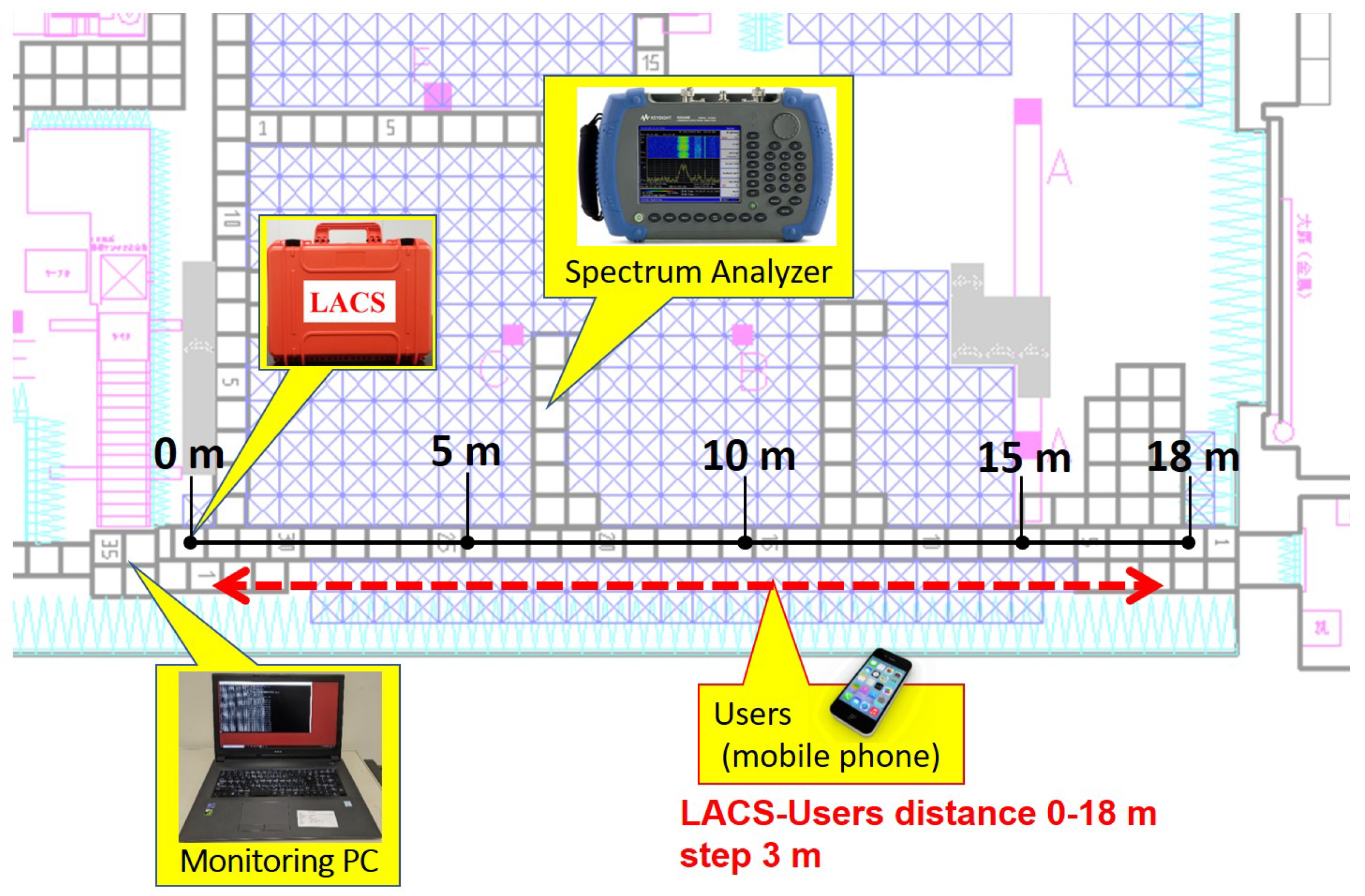
4.1. Experiment Setup

The aim of the experiment is to confirm the data transfer rate between the message ferry and a standalone LACS that is installed in the disaster shelter. In addition, the performance evaluation confirms the effective transmission speed of the message ferry that can be achieved for transferring data from the local headquarters to the shelters. Figure 9 shows the experimental environment. As illustrated, we used the LACS prototype, a computer running Wireshark to capture traffic to/from the standalone LACS, and a mobile phone connected to the standalone LACS via Wi-Fi. Since the weight of LACS (i.e., around 4.5 kg) is more than the maximum weight the drone of the message ferry can safely carry, we conducted the experiment using a mobile phone (i.e., the drone mounted with LACS is replaced with a mobile phone in the experiment.) The development of a smaller and compact size LACS is ongoing and will be utilized in the actual demonstration test of the message ferry in the future.
The LACS’s access point [34] frequency band is set to 2.4 GHz and 5 GHz. For the 2.4 GHz frequency band, the protocol setting is changed to IEEE 802.11 b and 802.11 g, while the following protocols: IEEE 802.11 a, 802.11 n, or 802.11 ac is selected for the 5 GHz frequency band. The 5 GHz band has a maximum data rate (theoretically) of 866 Mbps for IEEE 802.11 ac and 400 Mbps for the 2.4 GHz band [35]. The protocol used for each part of the experiment is verified with a Wi-Fi analyzer. In addition, we changed the distance between the mobile phone and LACS from 3 to 18 m. At each distance, the LACS is used to transfer data to/from the mobile phone. The traffic transmitted between the LACS and the mobile phone is captured by the Wireshark running on the computer. The size of the data (i.e., information to be delivered/collected) transferred between the mobile phone and the standalone LACS is between 1 MB–300 MB. Table 1 shows the settings and the parameters for the experiment.
In order to prevent interference from other radio waves, we performed the experiment in the anechoic chamber. Figure 10 show the measured results of the spectrum during the experiment. It was confirmed that there is no other wireless signal present during the experiment. As shown in Figure 10a, at a distance of 3 m, the spectrum analyzer confirms that the peak transmission power level of the wireless signal at a center frequency of 2.4 GHz on channel 6 is 40.0 dBm for 802.11 b. Furthermore, the distance between LACS and the mobile phone was increased to 18 m and the spectrum analyzer was placed in a fixed position during the experiment. It was confirmed that the transmission power of the wireless signal increased to a peak level of 22.5 dBm at a center frequency of 2.45 GHz on the same channel and protocol as shown in Figure 10b. The changes in the waveform observed in Figure 10b is as a result of the LACS using more transmission power (i.e., 17.5 dBm increase) to send a message to the mobile phone when the distance is changed from 3 to 18 m.
The message ferry will be used to transfer the important information (i.e., to/from the standalone LACS) from the local headquarters to the disaster shelters. We measure the achievable data transfer rate of the inter-LACS data transfer between the message ferry and the standalone LACS. Thereafter, we estimate the effective transmission speed of the message ferry at various coverage distances when the data are transferred using the data transfer rate achievable from the experimental results.

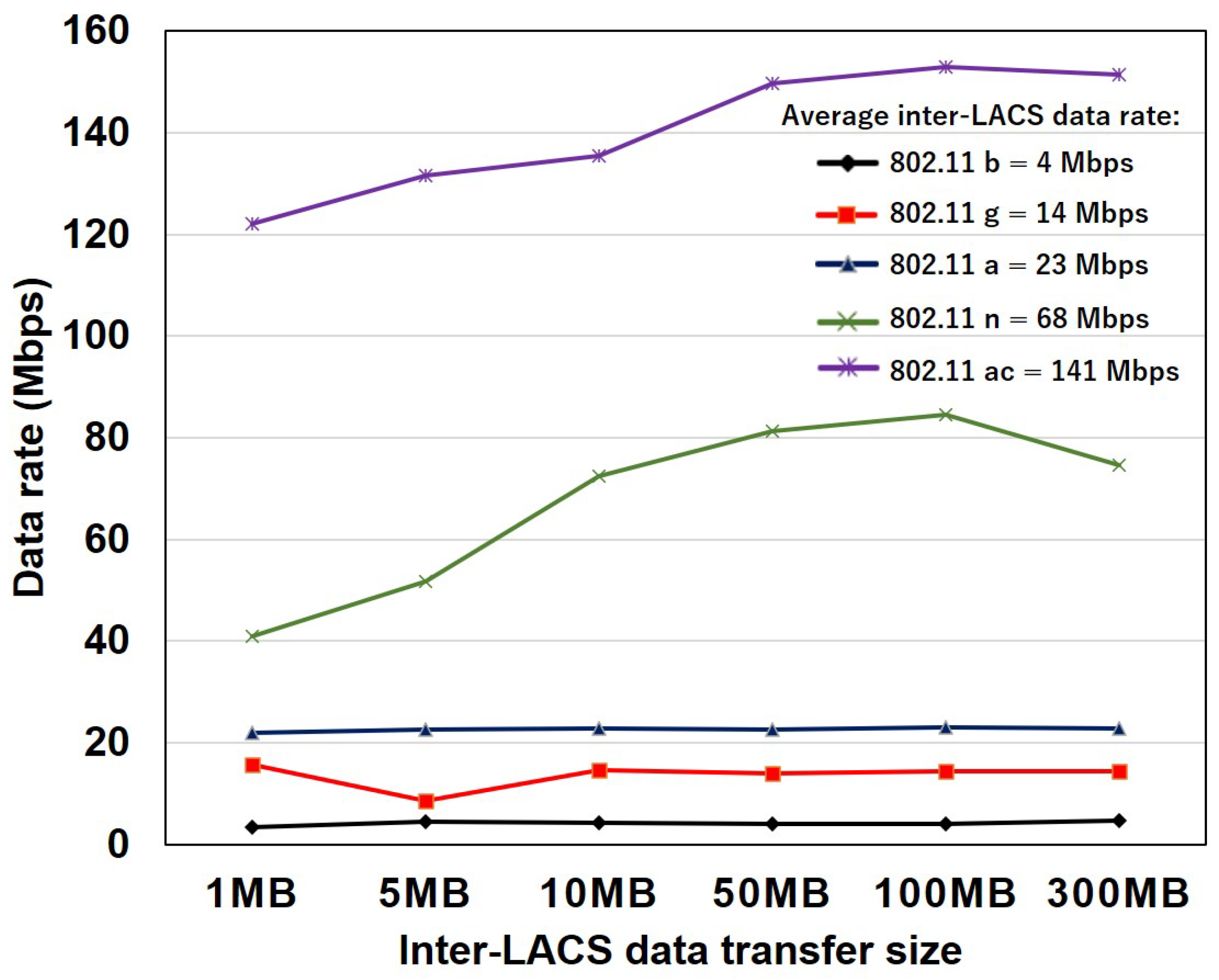
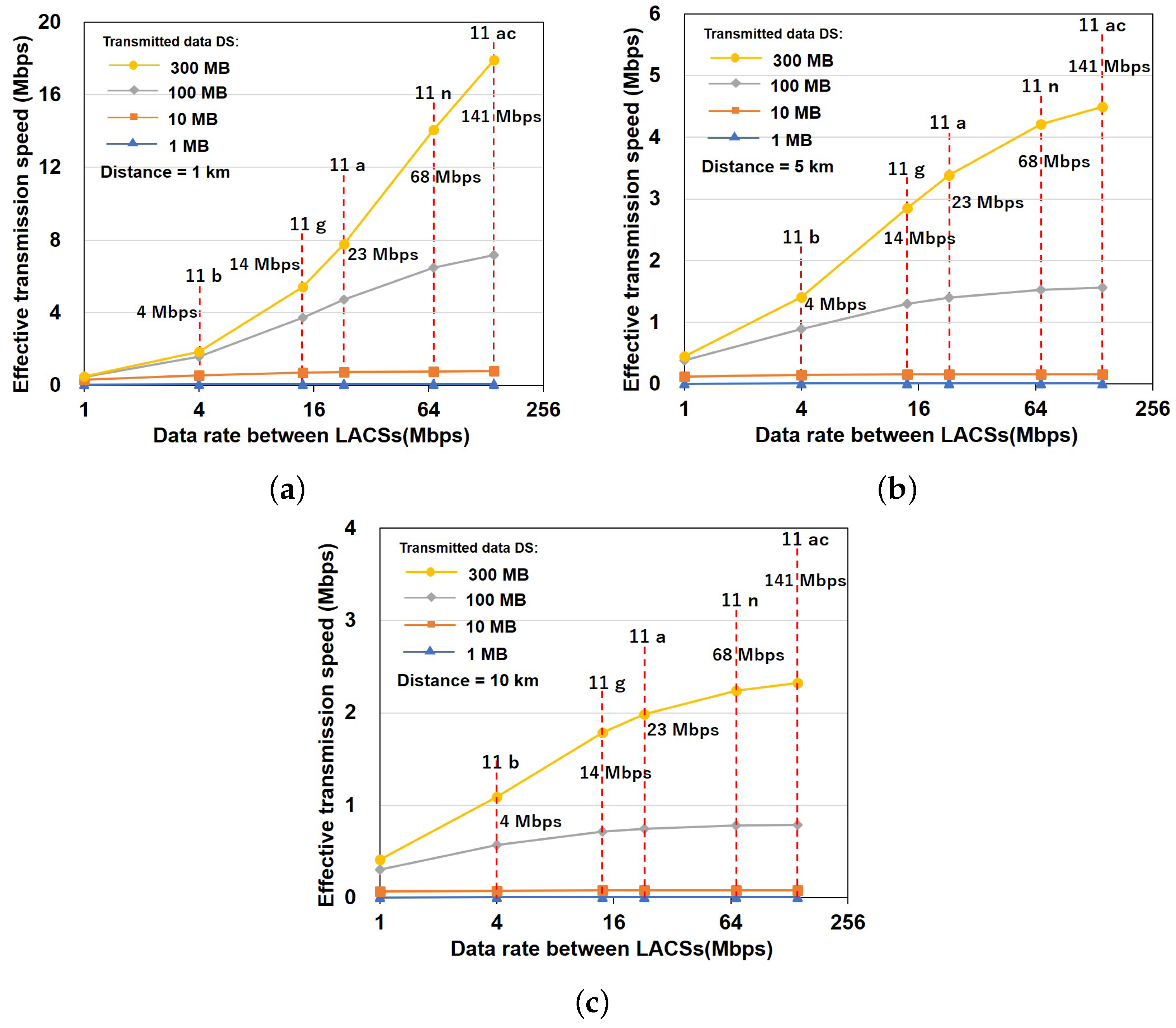
4.2. Results and Discussion

Figure 11 shows the measured average achievable data rate of inter-LACS data transfer on various IEEE 802.11 protocols when the data size transmitted are 1 MB, 5 MB, 10 MB, 100 MB and 300 MB. The average achievable inter-LACS data rate increases with the data size. The average achievable data rate is lower for both 802.11 b and g on 2.4 GHz frequency band compared to that of 802.11 a, n and ac on 5 GHz frequency band. An overall average inter-LACS data rate of 4 Mbps, 14 Mbps, 23 Mbps, 68 Mpbs, and 141 Mbps for 802.11 b, g, a, n, and ac respectively. A slight decrease in the measured inter-LACS data rate is observed when the data size is 5 MB, 100 MB, and 300 MB for 802.11 g, b and n. The cause of this slight decrease is the result of high delays possibly due to packet processing, packet segmentation, packet fragmentation and aggregation where packets are divided into equal/smaller fragments to the IP Maximum Transmission Units (MTUs) and reassembled at the destination.
To confirm the effective transmission speed that the message ferry can achieve to transfer messages from the local headquarters to each disaster shelter, we need to account for the time it will take the message ferry to carry the message from point A to point B (i.e., local headquarters and disaster shelter). Therefore, we derived Equation (1) considering the parameters of the message ferry. Equation (1) consists of two parts. The first part considered the inter-LACS data rate that can be achieved to transfer data between two LACSs. The second part is based on the time taken by the message ferry (i.e., based on parameters such as the size of the data, drone velocity, and the distance the message ferry need to cover) to carry the data from the local headquarters to the disaster shelter. We calculate the effective transmission speed of the message ferry at various distances of 1 m to 20,000 m using Equation (1), where T S [Mbps] is the effective transmission speed, R b [Mbps] is the data rate utilized at a particular time, v [m/s] is the speed of the drone, D S [Bytes] denotes the data size and D [m] is the distance. Moreover, the evacuee upload/download data to/from the standalone LACS installed in the disaster shelter, we assume that the size of the data to be transferred between the message ferry and the standalone LACS will be large. Therefore, the transmission speed of our proposed message ferry is calculated based on data size of 1 MB, 10 MB, 100 MB and 300 MB.
T S = 2 × 1 R b + D 8 × D S × v 1 .
Figure 12 shows the effective transmission speed of the message ferry on the 802.11 protocols using the overall approximate average achievable data rate obtained from the experiment when the inter-LACS data transfer size is 1 MB, 10 MB, 100 MB and 300 MB. The results confirm that the effective transmission speed increases as the overall average achievable data rate and data size increase. At a distance of 1 km as shown in Figure 12a, when the inter-LACS data transfer size is 300 MB and the overall achievable inter-LACS data rate is 141 Mbps for 802.11 ac, the effective transmission speed of the message ferry increased to an approximate 18 Mbps. In comparison, the message ferry using 802.11 ac outperforms other protocols: 802.11 b = 2 Mbps, 802.11 g = 5 Mbps, 802.11 a = 8 Mbps and 802.11 n = 14 Mbps. Similarly, as shown in Figure 12b,c, the same trend is confirmed. At a distance of 5 km and 10 km, the message ferry achieves higher effective transmission speed when the data size is 300 MB compared to other protocols.
Furthermore, our proposed message ferry is advantageous when transferring large data size when compared to other technologies such as Wi-SUN on a maximum data rate of 50 kbps and LoRa on 250 kbps. For example, to transfer a data size of 300 MB at a distance of 10 km, the proposed message ferry using Wi-Fi (IEEE 802.11ac protocol) achieves an effective transmission speed of 2.3 Mbps compared to 25 kbps for Wi-SUN and 119 kbps for LoRa.

5. Conclusions

In this paper, a drone-based message ferry is proposed to improve the urgent collection and delivery of essential post-disaster information. A message ferry is created by attaching LACS to a high performance drone. In the aftermath of a large-scale disaster, a message ferry is deployed to collect/deliver vital disaster information from and to the local headquarters (i.e., government office/disaster response coordination center) to each standalone LACS installed at the disaster shelters.
The performance of the proposed message ferry was evaluated through an experiment. In the experiments, the inter-LACS data transfer rate (throughput) was measured. The measured data transfer rate was then used to confirm the effective transmission speed for transferring data from the local headquarters to the shelters. Our experimental results and analysis confirmed that the proposed message ferry is advantageous when transferring a large amount of data (e.g., 300 MB) at a high speed, an effective transmission speed of 2.3 Mbps when the message ferry is deployed on 802.11 ac compared to technologies such as Wi-SUN (25 kbps) and LoRa (119 kbps). As a result, disaster response efforts to collect and deliver life-saving information from/to evacuees in a timely manner can be improved.
As part of our future work, a small and compact size LACS will be mounted on the drone which will be utilized in the actual demonstration test of the message ferry. In addition, the message ferry will be deployed to various disaster shelters in quasi real-time. Finally, we will consider using multiple message ferry and various routing protocols.

Author Contributions

Conceptualization, B.O. and T.S.; methodology, B.O.; software, B.O. and T.S.; validation, B.O., S.A. and T.S.; formal analysis, B.O. and T.S.; investigation, B.O. and S.A.; resources, S.A. and T.S.; data curation, B.O. and T.S.; writing—original draft preparation, B.O.; writing—review and editing, B.O., S.A. and T.S.; visualization, B.O.; supervision, T.S.; project administration, T.S.; funding acquisition, T.S. All authors have read and agreed to the published version of the manuscript.

Funding

This work was supported by Council for Science, Technology and Innovation(CSTI), Cross-ministerial Strategic Innovation Promotion Program (SIP), Enhancement of National Resilience against Natural Disasters (Funding agency: National Research Institute for Earth Science and Disaster Resilience - Contract number: 22-I-9).

Institutional Review Board Statement

Not applicable.

Informed Consent Statement

Not applicable.

Data Availability Statement

Not applicable.

Acknowledgments

This work was supported by Council for Science, Technology and Innovation (CSTI), Cross-ministerial Strategic Innovation Promotion Program (SIP), Enhancement of National Resilience against Natural Disasters (Funding agency: National Research Institute for Earth Science and Disaster Resilience - Contract number: 22-I-9). We thank Blue Innovation Co., Ltd for its support in drone-based testing.

Conflicts of Interest

The authors declare no conflict of interest. The funding organization had no role in the design of the study; in the collection, analyses, or interpretation of data; in the writing of the manuscript, or in the decision to publish the results.

Abbreviations

The following abbreviations are used in this manuscript:
UAVUnmanned Aerial Vehicle
LACSLocally Accessible Cloud System
ICTInformation and Communications Technology
MANETMobile Ad-hoc NETwork
SIP4DShared Information Platform for Disaster Management

References

  1. Luo, C.; Miao, W.; Ullah, H.; McClean, S.; Parr, G.; Min, G. Unmanned Aerial Vehicles for Disaster Management. In Geological Disaster Monitoring Based on Sensor Networks; Durrani, T., Wang, W., Forbes, S., Eds.; Springer Natural Hazards; Springer: Singapore, 2019. [Google Scholar] [CrossRef]
  2. Nippon Telegraph and Telephone East Corporation (NTT-East). Status of Full-Fledged Recovery following the Great East Japan Earthquake and Future Measures. Available online: https://www.ntt-east.co.jp/en/release/detail/pdf/20120301_02_01.pdf (accessed on 27 January 2022).
  3. Kishorbhai, V.Y.; Vasantbhai, N.N. AON: A Survey on Emergency Communication Systems during a Catastrophic Disaster. Procedia Comput. Sci. 2017, 115, 838–845. [Google Scholar] [CrossRef]
  4. Ishimaru, Y.; Sun, W.; Yasumoto, K.; Ito, M. DTN-based Delivery of Word-of-Mouth Information with Priority and Deadline. In Proceedings of the 5th International Conference on Mobile Computing and Ubiquitous Networking (ICMU), Seattle, WA, USA, 26–28 April 2010; pp. 179–185. [Google Scholar]
  5. Ueda, Y. Vehicle-mounted Transportable Mobile Base Station and Backhaul Link for Disaster Relief Operation. The ITU Association of Japan, New Breeze 2014; Volume 26, No. 3, pp. 2–3. Available online: https://www.ituaj.jp/wp-content/uploads/2014/07/nb26-3_web-2_sf_mobile-1.pdf (accessed on 27 January 2022).
  6. Kumbhar, A.; Singh, S.; Guvenc, I. UAV assisted public safety communications with LTE-Advanced HetNets and FeICIC. In Proceedings of the 2017 IEEE 28th Annual International Symposium on Personal, Indoor, and Mobile Radio Communications (PIMRC), Montreal, QC, Canada, 8–13 October 2017; pp. 1–7. [Google Scholar] [CrossRef] [Green Version]
  7. Pozza, M.; Rao, A.; Flinck, H.; Tarkoma, S. Network-In-a-Box: A Survey About On-Demand Flexible Networks. IEEE Commun. Surv. Tutor. 2018, 20, 2407–2428. [Google Scholar] [CrossRef] [Green Version]
  8. Kunz, A.; Tanaka, I.; Husain, S.S. Disaster response in 3gpp mobile networks. In Proceedings of the 2013 IEEE International Conference on Communications Workshops (ICC), Budapest, Hungary, 9–13 June 2013; pp. 1226–1231. [Google Scholar]
  9. Aoyagi, K.; Hapsari, W.A.; Takeda, S.; Tanaka, I. Further Development of LTE-Advanced—Release 12 Standardization Trends—Access Class Control Technology in LTE/LTE-Advanced Systems. NTT DOCOMO Tech. J. 2015, 17, 65–76. Available online: https://www.docomo.ne.jp/english/binary/pdf/corporate/technology/rd/technical_journal/bn/vol17_2/vol17_2_000en.pdf (accessed on 1 April 2022).
  10. Fotouhi, A.; Ding, M.; Hassan, M. Dynamic base station repositioning to improve spectral efficiency of drone small cells. In Proceedings of the 2017 IEEE 18th International Symposium on A World of Wireless, Mobile and Multimedia Networks (WoWMoM), Macau, China, 12–15 June 2017; pp. 1–9. [Google Scholar] [CrossRef] [Green Version]
  11. Uchida, O.; Kosugi, M.; Endo, G.; Funayama, T.; Utsu, K.; Tajima, S.; Tomita, M.; Kajita, Y.; Yamamoto, Y. A Real-Time Disaster-Related Information Sharing System Based on the Utilization of Twitter. In Proceedings of the SOTICS 2015: The Fifth International Conference on Social Media Technologies, Communication and Informatics, Barcelona, Spain, 15–20 November 2015; pp. 22–25. [Google Scholar]
  12. George, S.; Zhou, W.; Chenji, H.; Won, M.; Lee, Y.; Pazarloglou, A.; Stoleru, R.; Barooah, P. DistressNet: A wireless ad hoc and sensor network architecture for situation management in disaster response. IEEE Commun. Mag. 2010, 48, 128–136. [Google Scholar] [CrossRef]
  13. Nishiyama, H.; Ito, M.; Kato, N. Relay-by-smartphone: Realizing multihop device-to-device communications. IEEE Commun. Mag. 2014, 52, 56–65. [Google Scholar] [CrossRef]
  14. Mishra, A.; Nadkarni, K.M. Security in Wireless Ad Hoc Networks; CRC Press LLC: Boca Raton, FL, USA, 2003; Chapter 30. [Google Scholar]
  15. Ojetunde, B.; Sakano, T.; Suzuki, Y. Information Delivery and Collection System Based on Locally Accessible System. In Proceedings of the 2021 International Conference on Information and Communication Technologies for Disaster Management (ICT-DM), Hangzhou, China, 3–5 December 2021; pp. 142–149. [Google Scholar] [CrossRef]
  16. Sakano, T.; Teng, R.; Yano, K.; Shimizu, S.; Suzuki, Y. A Study on a system for alleviating communication difficulty based on promptly deployable local clouds in the disaster affected areas. In Proceedings of the IEICE General Conference, Tokyo, Japan, 19–22 March 2019; pp. 7–46. [Google Scholar]
  17. Teng, R.; Sakano, T.; Suzuki, Y. Instantaneous Networking Service Availability for Disaster Recovery. Appl. Sci. 2020, 10, 9030. [Google Scholar] [CrossRef]
  18. Harounabadi, M.; Bocksberger, M.; Mitschele-Thiel, A. Study on the Network Architectures for Message Ferry Networks with Multiple UAVs. In Proceedings of the 2018 Tenth International Conference on Ubiquitous and Future Networks (ICUFN), Prague, Czech Republic, 3–6 July 2018; pp. 59–63. [Google Scholar] [CrossRef]
  19. Barroca, C.; Grilo, A.; Pereira, P.R. Improving Message Delivery in UAV-based Delay Tolerant Networks. In Proceedings of the 2018 16th International Conference on Intelligent Transportation Systems Telecommunications (ITST), Lisboa, Portugal, 15–17 October 2018; pp. 1–7. [Google Scholar] [CrossRef]
  20. Nguyen, M.T.; Nguyen, C.V.; Do, H.T.; Hua, H.T.; Tran, T.A.; Nguyen, A.D.; Ala, G.; Viola, F. UAV-Assisted Data Collection in Wireless Sensor Networks: A Comprehensive Survey. Electronics 2021, 10, 2603. [Google Scholar] [CrossRef]
  21. Arafat, M.Y.; Moh, S. Routing Protocols for Unmanned Aerial Vehicle Networks: A Survey. IEEE Access 2019, 7, 99694–99720. [Google Scholar] [CrossRef]
  22. Harada, H.; Mizutani, K.; Fujiwara, J.; Mochizuki, K.; Obata, K.; Okumura, R. IEEE 802.15.4g Based Wi-SUN Communication Systems. IEICE Trans. Commun. 2017, E100-B, 1032–1043. [Google Scholar] [CrossRef] [Green Version]
  23. Seferagić, A.; Famaey, J.; De Poorter, E.; Hoebeke, J. Survey on Wireless Technology Trade-Offs for the Industrial Internet of Things. Sensors 2020, 20, 488. [Google Scholar] [CrossRef] [PubMed] [Green Version]
  24. Sakano, T.; Ojetunde, B.; Suzuki, Y.; Llanto, J.; Sharmaand, C. Feasibility study of Locally Accessible Cloud System (LACS) conducted in a remote island in Cebu, Philippines to meet the real demand for ICT under the COVID-19 pandemic. In Proceedings of the 2nd International Symposium on Disaster Resilience & Sustainable Development, Online, 24–25 June 2021. [Google Scholar]
  25. International Telecommunication Union (ITU). Utilizing Telecommunications/Information and Communication Technologies for Disaster Risk Reduction and Management: Output Report on ITU-D Question 5/2 for the Study Period 2018–2021. Annex 1. Detailed Use Cases: Disaster Communication Technologies—Locally Accessible Cloud System. 2021; pp. 71–74. Available online: https://www.itu.int/dms_pub/itu-d/opb/stg/D-STG-SG02.05.2-2021-PDF-E.pdf (accessed on 1 April 2022).
  26. Varghese, B.; Wang, N.; Barbhuiya, S.; Kilpatrick, P.; Nikolopoulos, D.S. Challenges and Opportunities in Edge Computing. In Proceedings of the 2016 IEEE International Conference on Smart Cloud (SmartCloud), New York, NY, USA, 18–20 November 2016; pp. 20–26. [Google Scholar] [CrossRef] [Green Version]
  27. Usuda, Y.; Hanashima, M.; Sato, R.; Sano, H. Effects and Issues of Information Sharing System for Disaster Response. J. Disaster Res. 2017, 12, 1002–1014. [Google Scholar] [CrossRef]
  28. Owada, Y.; Kuri, T. Toward Distributed Edge Cloud Systems for Smart and Resilient Social Infrastructure. In NICT News. Available online: https://www.nict.go.jp/en/data/nict-news/NICT_NEWS_2021-487_E.pdf (accessed on 27 January 2022).
  29. Laghari, A.A.; He, H.; Khan, A.; Karim, S. Impact of Video File Format on Quality of Experience (QoE) of Multimedia Content. 3D Res 2018, 9, 39. [Google Scholar] [CrossRef]
  30. Usuda, Y.; Matsui, T.; Deguchi, H.; Hori, T.; Suzuki, S. The Shared Information Platform for Disaster Management—The Research and Development Regarding Technologies for Utilization of Disaster Information. J. Disaster Res. 2019, 14, 279–291. [Google Scholar] [CrossRef]
  31. Nguyen, V.-L.; Lin, P.-C.; Hwang, R.-H. Energy Depletion Attacks in Low Power Wireless Networks. IEEE Access 2019, 7, 51915–51932. [Google Scholar] [CrossRef]
  32. Medina, C.A.; Pérez, M.R.; Trujillo, L.C. IoT Paradigm into the Smart City Vision: A Survey. In Proceedings of the 2017 IEEE International Conference on Internet of Things (iThings) and IEEE Green Computing and Communications (GreenCom) and IEEE Cyber, Physical and Social Computing (CPSCom) and IEEE Smart Data (SmartData), Exeter, UK, 21–23 June 2017; pp. 695–704. [Google Scholar] [CrossRef]
  33. ACSL ACSL-PF2 Industrial Platforms. Available online: https://vfr.co.jp/wp-content/uploads/2021/06/PF2_A4_01_EN_compressed.pdf (accessed on 1 April 2022).
  34. Buffalo FS-M1266 Series. FS-M1266. Available online: https://www.buffalo.jp/product/detail/fs-m1266.html (accessed on 27 January 2022).
  35. Intel. Different Wi-Fi Protocols and Data Rates. Available online: https://www.intel.com/content/www/us/en/support/articles/000005725/network-and-i-o/wireless.html (accessed on 27 January 2022).
Figure 1. LACS prototype.
Applsci 12 06547 g001
Figure 2. LACS features.
Applsci 12 06547 g002
Figure 3. Use of LACS for disaster response.
Applsci 12 06547 g003
Figure 4. Information delivery/collection between users at an disaster shelter and movable LACS.
Applsci 12 06547 g004
Figure 5. Information delivery/collecting between standalone LACS deployed to a disaster shelter and movable LACS.
Applsci 12 06547 g005
Figure 6. Proposed message ferry using LACS for disaster information collection/delivery.
Applsci 12 06547 g006
Figure 7. The message ferry as a link in the LACS network.
Applsci 12 06547 g007
Figure 8. Demonstration test of the drone-based message ferry. (a) Take-off of a drone attached with LACS. (b) Drone attached with LACS in the air.
Applsci 12 06547 g008
Figure 9. Experimental environment.
Applsci 12 06547 g009
Figure 10. Spectrum analyzer of the experiment environment. (a) Spectrum image of 802.11 b at 3 m. (b) Spectrum image of 802.11 b at 18 m.
Applsci 12 06547 g010
Figure 11. Inter-LACS data rate.
Applsci 12 06547 g011
Figure 12. Comparison of Effective transmission speed on IEEE 802.11 protocols. UAV’s velocity = 10 m/s. (a) Effective transmission speed at 1 km. (b) Effective transmission speed at 5 km. (c) Effective transmission speed at 10 km.
Applsci 12 06547 g012
Table 1. Experiment Parameters.
ParametersValue
Number of LACS1
Protocolb/g,
802.11 ac/n/a
LACS AP frequency band2.4/5 GHz
Channel width20/40/80 MHz
Maximum Data rate11, 54, 300, 866 Mbps
Number of movable LACS (mobile phone)1
Distance to LACS3–18 m
Data Size1–300 MB
Publisher’s Note: MDPI stays neutral with regard to jurisdictional claims in published maps and institutional affiliations.

