
Landslide Susceptibility Assessment by Using Convolutional Neural Network


Abstract
:1. Introduction
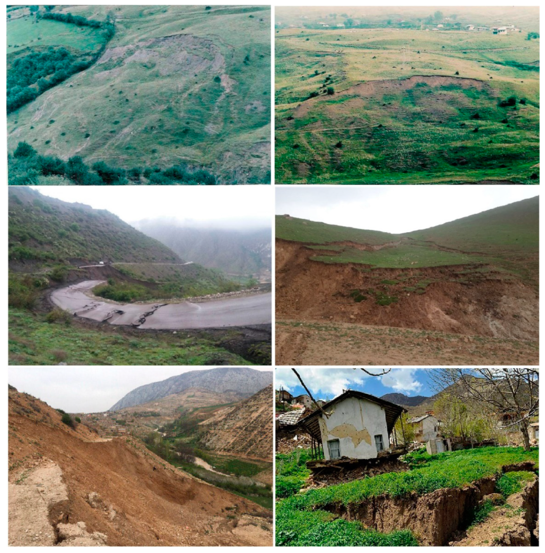
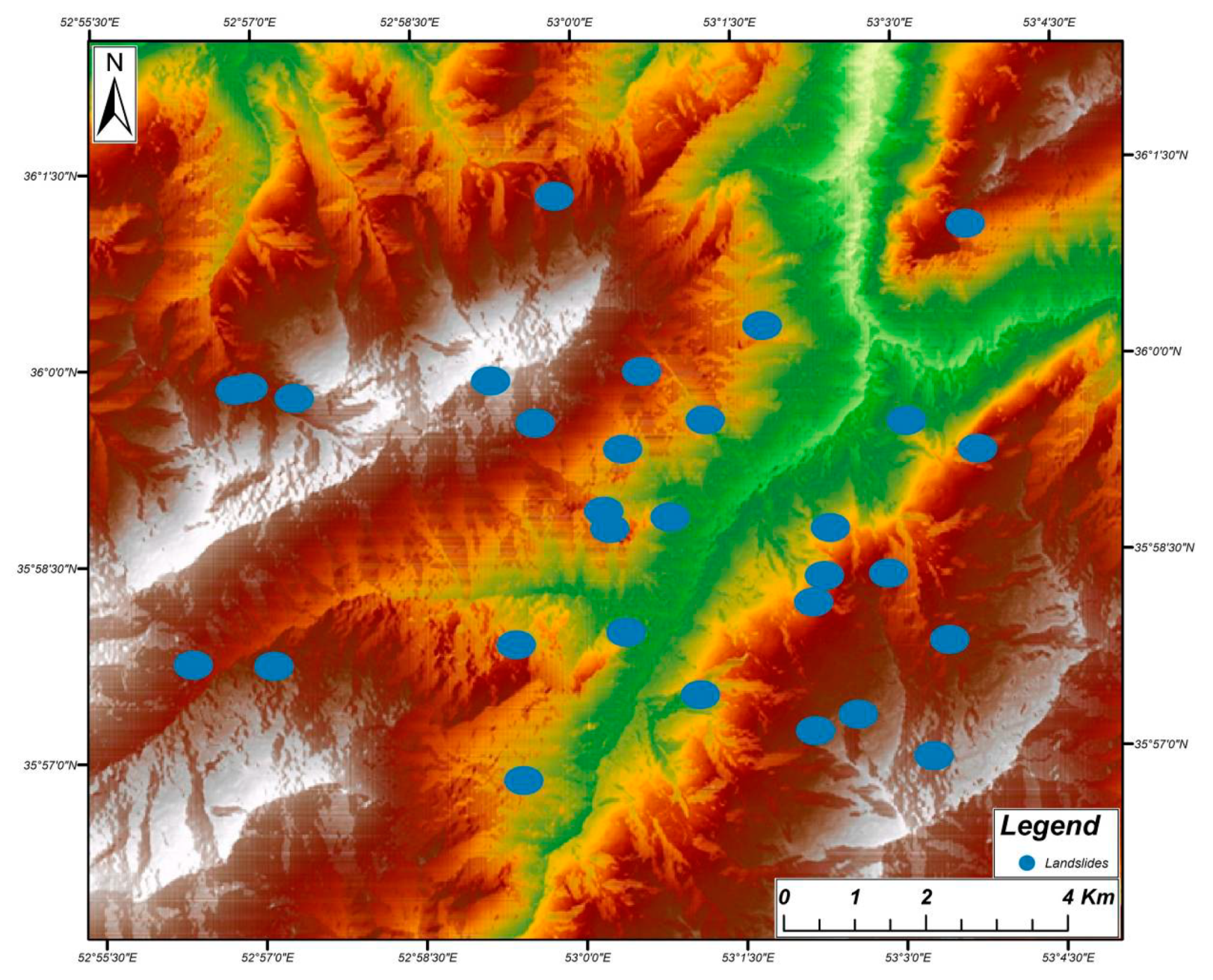
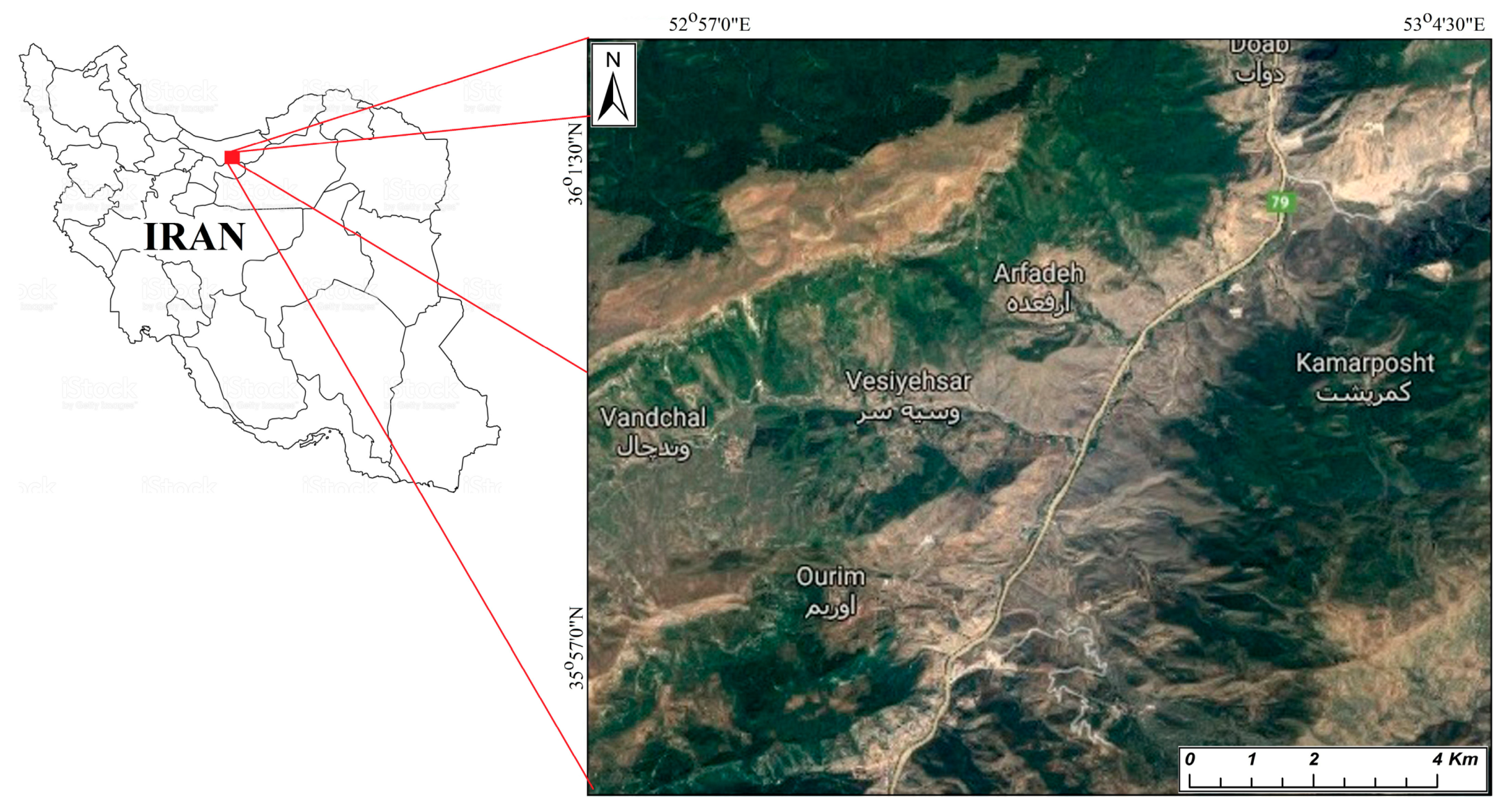
2. Study Area
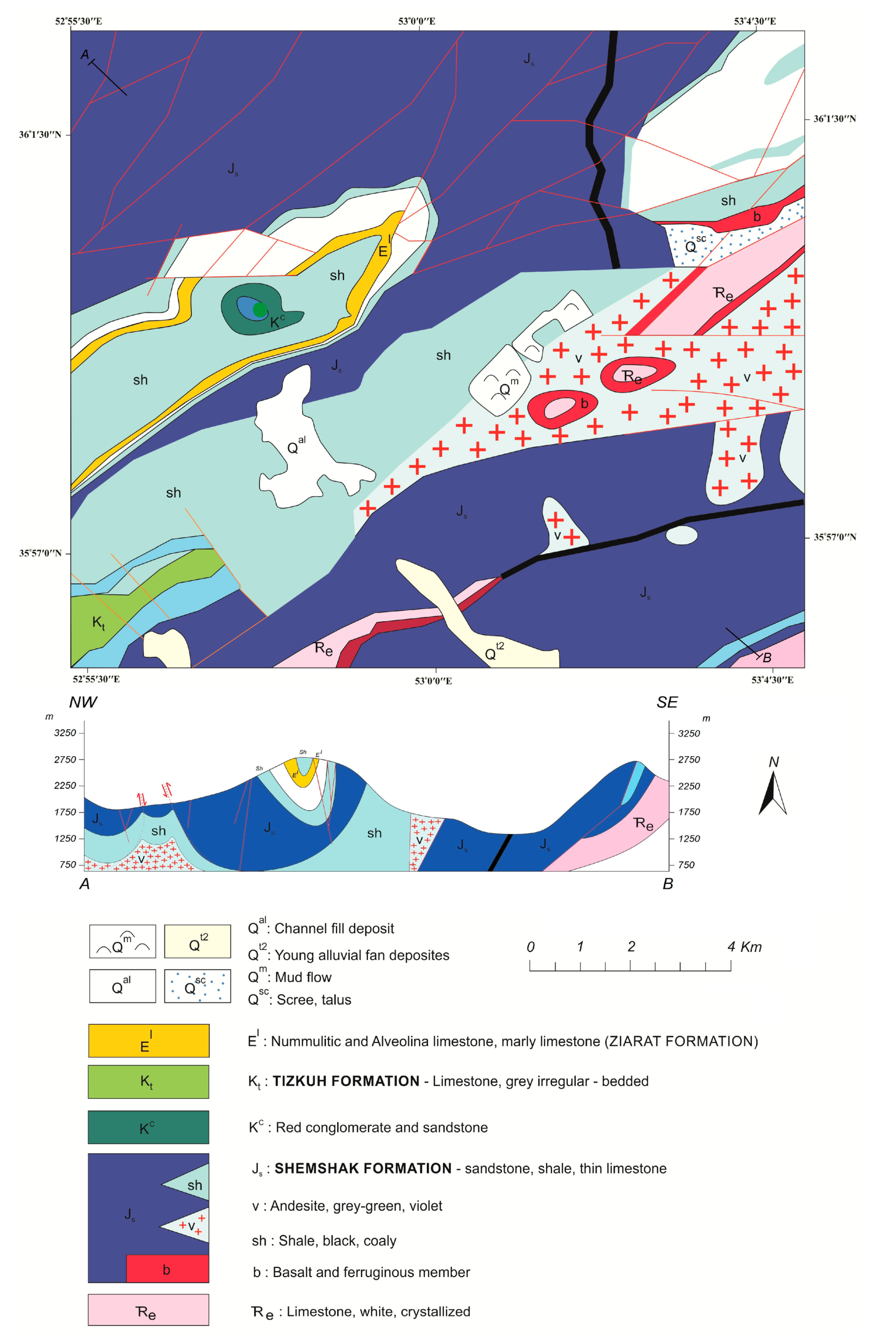
2.1. Geological Setting
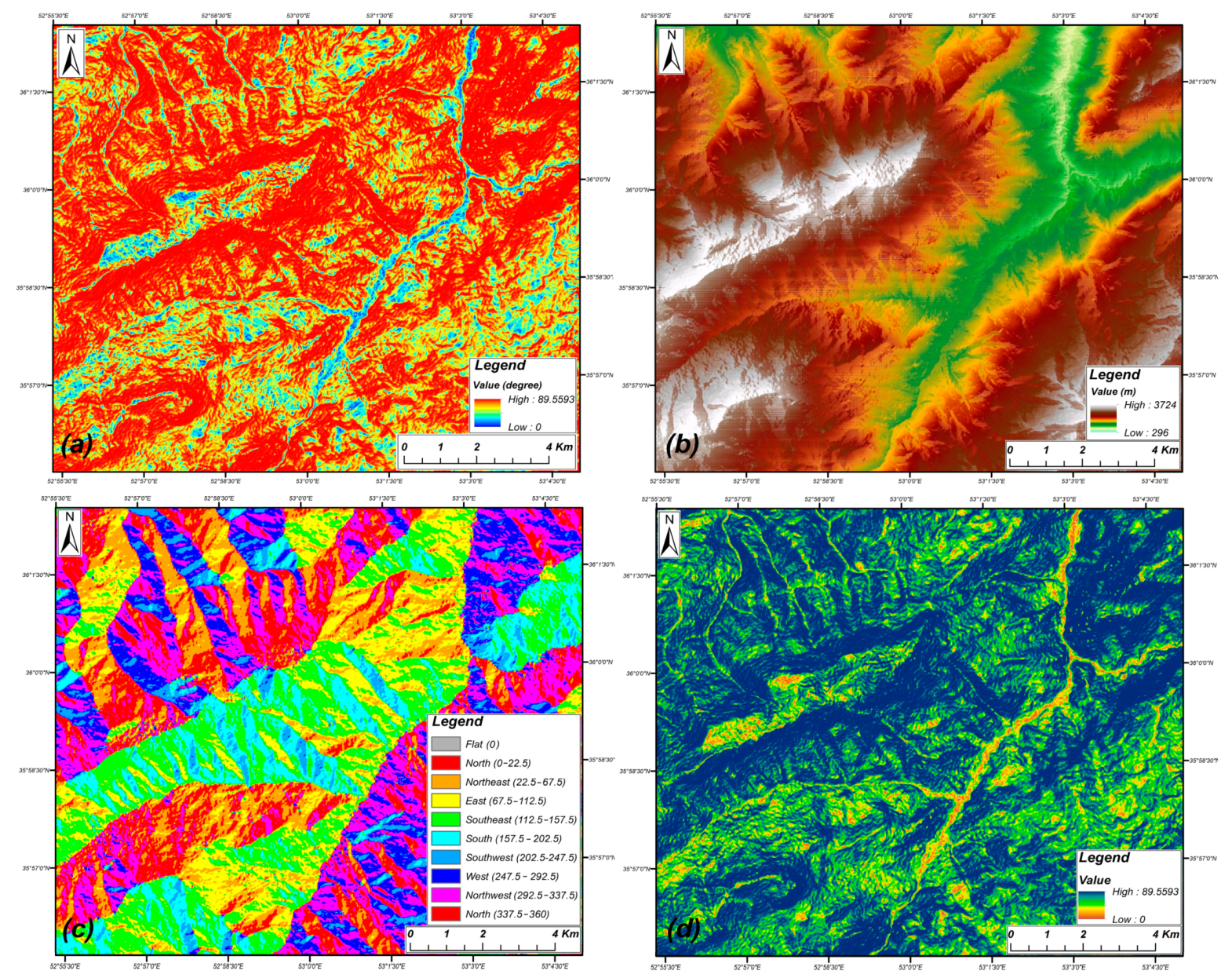
2.2. Landslide Influencing Factors
3. Materials and Methods
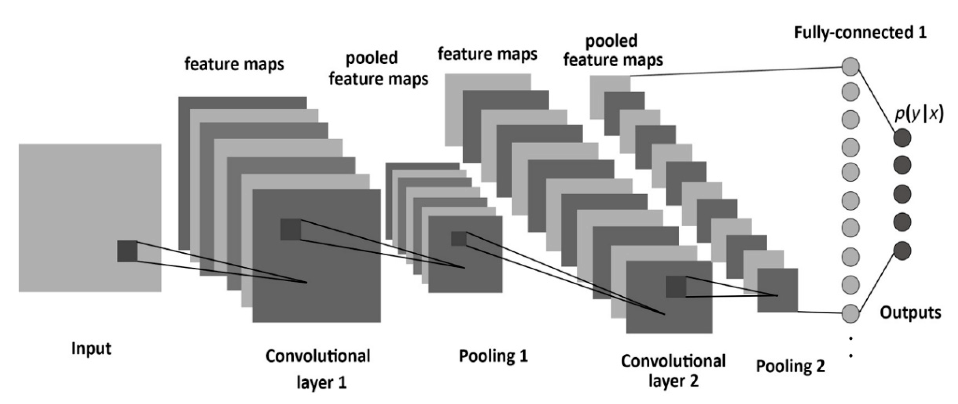
3.1. CNN-Based Model
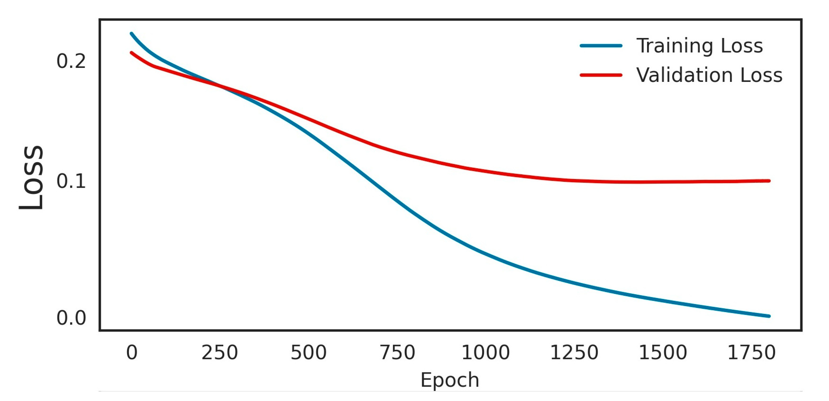
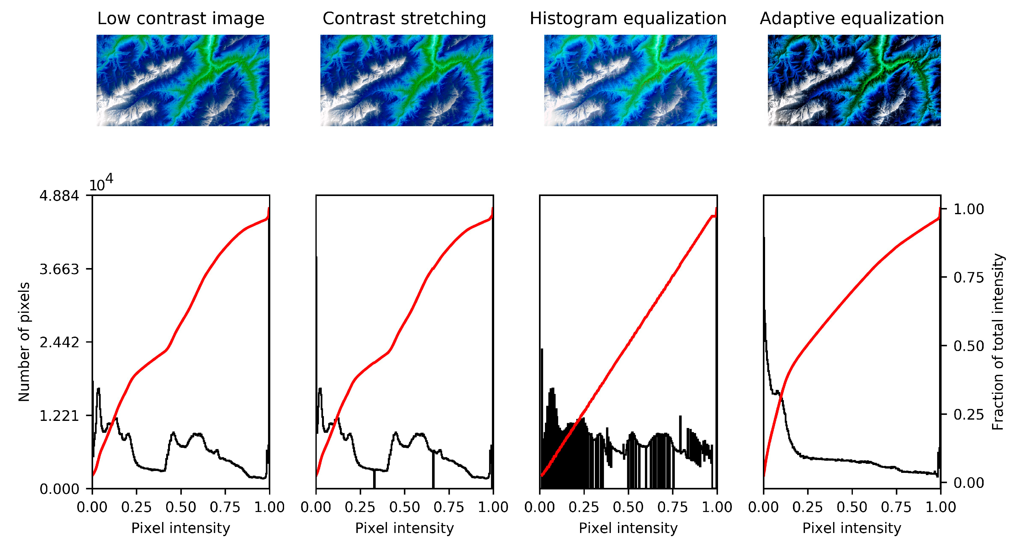
3.2. Model Data and Implementation
3.3. Model Cross-Verification
4. Results and Discussion
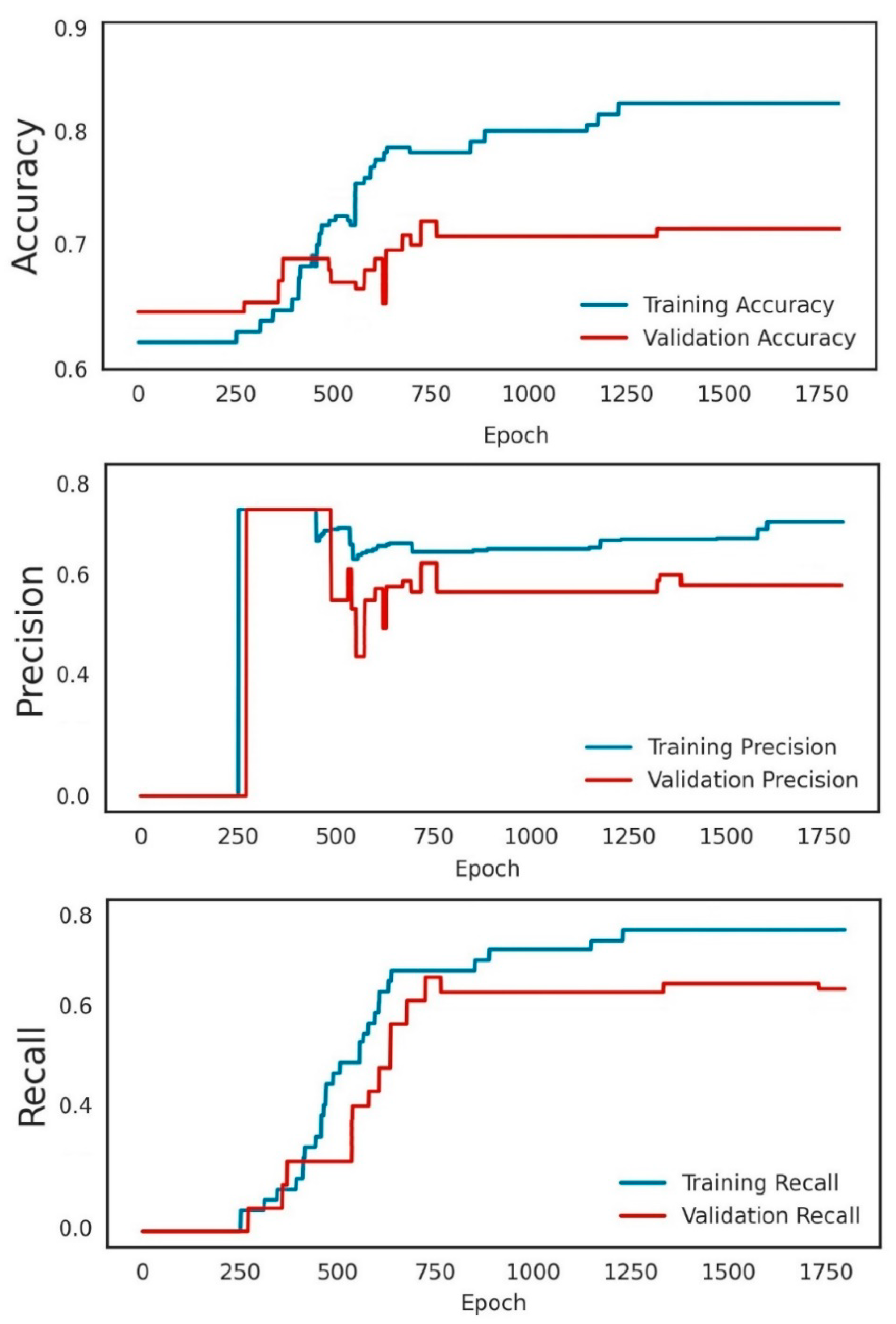
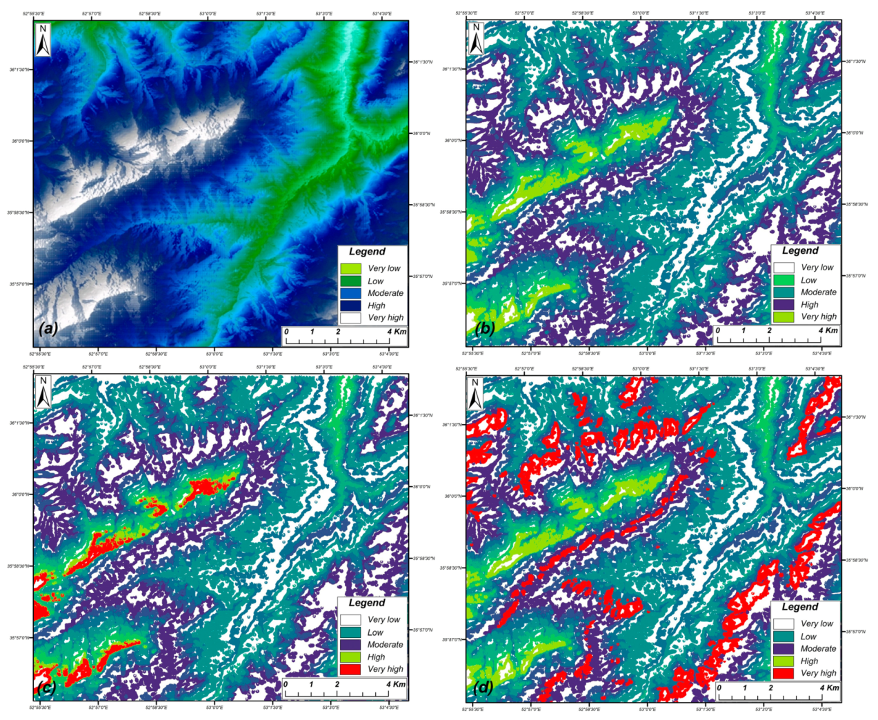
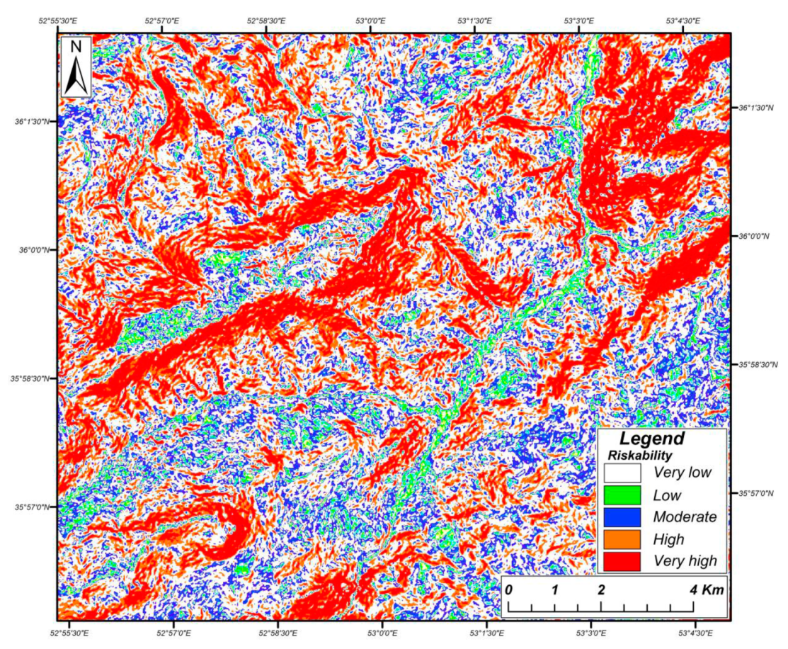
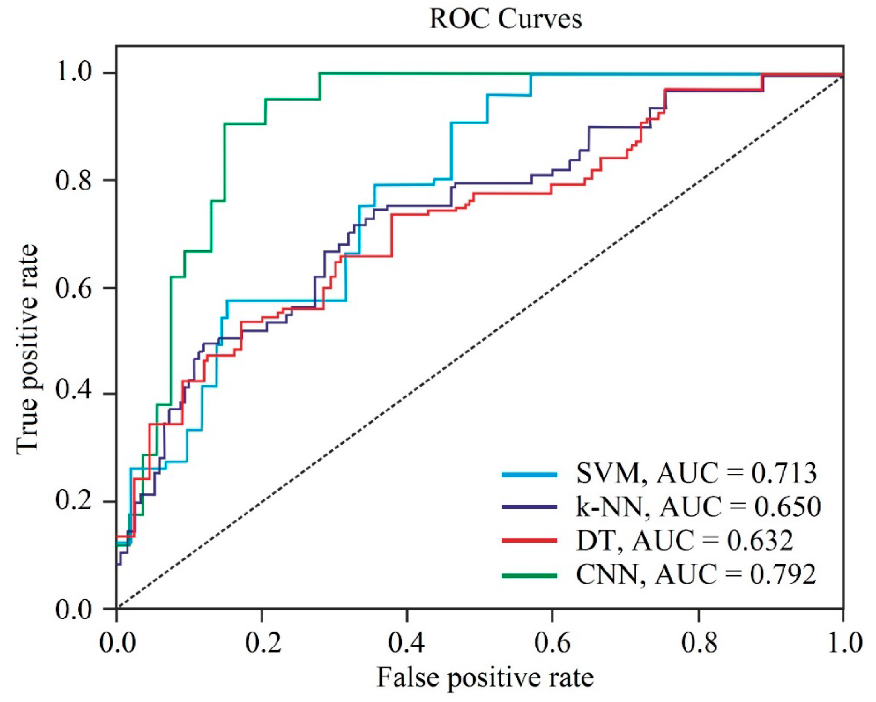
4.1. Results
4.2. Discussion
- The primary database was provided based on reports, historical landslide locations, field surveys, and remote sensing data, which is challenged by a limited personal budget;
- The triggering factors’ data is highly dependent on the satellite imagery resolution and DEM data quality, which affect directly the primary dataset; and
- Deep learning requires strong processing hardware to conduct accurate mapping.
5. Conclusions
Author Contributions
Funding
Institutional Review Board Statement
Informed Consent Statement
Data Availability Statement
Conflicts of Interest
References
- Nanehkaran, Y.A.; Mao, Y.; Azarafza, M.; Kockar, M.K.; Zhu, H.-H. Fuzzy-based multiple decision method for landslide susceptibility and hazard assessment: A case study of Tabriz, Iran. Geomech. Eng. 2021, 24, 407–418. [Google Scholar] [CrossRef]
- Rashidi, A.; Khatib, M.M.; Derakhshani, R. Structural Characteristics and Formation Mechanism of the Earth Fissures as a Geohazard in Birjand, Iran. Appl. Sci. 2022, 12, 4144. [Google Scholar] [CrossRef]
- Azarafza, M.; Azarafza, M.; Akgün, H.; Atkinson, P.M.; Derakhshani, R. Deep learning-based landslide susceptibility mapping. Sci. Rep. 2021, 11, 24112. [Google Scholar] [CrossRef] [PubMed]
- Akgun, A. A comparison of landslide susceptibility maps produced by logistic regression, multi-criteria decision, and likelihood ratio methods: A case study at İzmir, Turkey. Landslides 2012, 9, 93–106. [Google Scholar] [CrossRef]
- Pourkhosravani, M.; Mehrabi, A.; Pirasteh, S.; Derakhshani, R. Monitoring of Maskun landslide and determining its quantitative relationship to different climatic conditions using D-InSAR and PSI techniques. Geomat. Nat. Hazards Risk 2022, 13, 1134–1153. [Google Scholar] [CrossRef]
- Ercanoglu, M.; Gokceoglu, C. Assessment of landslide susceptibility for a landslide-prone area (north of Yenice, NW Turkey) by fuzzy approach. Environ. Geol. 2002, 41, 720–730. [Google Scholar] [CrossRef]
- Ercanoglu, M.; Gokceoglu, C. Use of fuzzy relations to produce landslide susceptibility map of a landslide prone area (West Black Sea Region, Turkey). Eng. Geol. 2004, 75, 229–250. [Google Scholar] [CrossRef]
- Akgun, A.; Dag, S.; Bulut, F. Landslide susceptibility mapping for a landslide-prone area (Findikli, NE of Turkey) by likelihood-frequency ratio and weighted linear combination models. Environ. Geol. 2008, 54, 1127–1143. [Google Scholar] [CrossRef]
- Abella, E.A.C.; Van Westen, C.J. Qualitative landslide susceptibility assessment by multicriteria analysis: A case study from San Antonio del Sur, Guantánamo, Cuba. Geomorphology 2008, 94, 453–466. [Google Scholar] [CrossRef] [Green Version]
- Arabameri, A.; Pradhan, B.; Rezaei, K.; Lee, C.-W. Assessment of landslide susceptibility using statistical-and artificial intelligence-based FR–RF integrated model and multiresolution DEMs. Remote Sens. 2019, 11, 999. [Google Scholar] [CrossRef] [Green Version]
- Arabameri, A.; Pradhan, B.; Rezaei, K.; Lee, S.; Sohrabi, M. An ensemble model for landslide susceptibility mapping in a forested area. Geocarto Int. 2020, 35, 1680–1705. [Google Scholar] [CrossRef]
- Arabameri, A.; Pradhan, B.; Rezaei, K.; Sohrabi, M.; Kalantari, Z. GIS-based landslide susceptibility mapping using numerical risk factor bivariate model and its ensemble with linear multivariate regression and boosted regression tree algorithms. J. Mt. Sci. 2019, 16, 595–618. [Google Scholar] [CrossRef]
- Duman, T.; Can, T.; Gokceoglu, C.; Nefeslioglu, H.; Sonmez, H. Application of logistic regression for landslide susceptibility zoning of Cekmece Area, Istanbul, Turkey. Environ. Geol. 2006, 51, 241–256. [Google Scholar] [CrossRef]
- Nefeslioglu, H.A.; Duman, T.Y.; Durmaz, S. Landslide susceptibility mapping for a part of tectonic Kelkit Valley (Eastern Black Sea region of Turkey). Geomorphology 2008, 94, 401–418. [Google Scholar] [CrossRef]
- Ruff, M.; Czurda, K. Landslide susceptibility analysis with a heuristic approach in the Eastern Alps (Vorarlberg, Austria). Geomorphology 2008, 94, 314–324. [Google Scholar] [CrossRef]
- Yilmaz, I. Landslide susceptibility mapping using frequency ratio, logistic regression, artificial neural networks and their comparison: A case study from Kat landslides (Tokat—Turkey). Comput. Geosci. 2009, 35, 1125–1138. [Google Scholar] [CrossRef]
- Othman, A.N.; Naim, W.M.; Noraini, S. GIS based multi-criteria decision making for landslide hazard zonation. Procedia Soc. Behav. Sci. 2012, 35, 595–602. [Google Scholar] [CrossRef] [Green Version]
- Papathanassiou, G.; Valkaniotis, S.; Ganas, A.; Pavlides, S. GIS-based statistical analysis of the spatial distribution of earthquake-induced landslides in the island of Lefkada, Ionian Islands, Greece. Landslides 2013, 10, 771–783. [Google Scholar] [CrossRef]
- Azarafza, M.; Akgün, H.; Feizi-Derakhshi, M.-R.; Azarafza, M.; Rahnamarad, J.; Derakhshani, R. Discontinuous rock slope stability analysis under blocky structural sliding by fuzzy key-block analysis method. Heliyon 2020, 6, e03907. [Google Scholar] [CrossRef] [PubMed]
- Azarafza, M.; Akgün, H.; Ghazifard, A.; Asghari-Kaljahi, E.; Rahnamarad, J.; Derakhshani, R. Discontinuous rock slope stability analysis by limit equilibrium approaches–a review. Int. J. Digit. Earth 2021, 14, 1918–1941. [Google Scholar] [CrossRef]
- Eker, A.M.; Dikmen, M.; Cambazoglu, S.; Duzgun, S.H.; Akgun, H. Application of artificial neural network and logistic regression methods to landslide susceptibility mapping and comparison of the results for the ulus district, bartin. J. Fac. Eng. Archit. Gazi Univ. 2012, 27, 163–173. [Google Scholar]
- Eker, A.M.; Dikmen, M.; Cambazoğlu, S.; Düzgün, Ş.H.; Akgün, H. Evaluation and comparison of landslide susceptibility mapping methods: A case study for the Ulus district, Bartın, northern Turkey. Int. J. Geogr. Inf. Sci. 2015, 29, 132–158. [Google Scholar] [CrossRef]
- Zhu, A.-X.; Miao, Y.; Wang, R.; Zhu, T.; Deng, Y.; Liu, J.; Yang, L.; Qin, C.-Z.; Hong, H. A comparative study of an expert knowledge-based model and two data-driven models for landslide susceptibility mapping. Catena 2018, 166, 317–327. [Google Scholar] [CrossRef]
- Pham, B.T.; Bui, D.T.; Dholakia, M.; Prakash, I.; Pham, H.V. A comparative study of least square support vector machines and multiclass alternating decision trees for spatial prediction of rainfall-induced landslides in a tropical cyclones area. Geotech. Geol. Eng. 2016, 34, 1807–1824. [Google Scholar] [CrossRef]
- Hong, H.; Pourghasemi, H.R.; Pourtaghi, Z.S. Landslide susceptibility assessment in Lianhua County (China): A comparison between a random forest data mining technique and bivariate and multivariate statistical models. Geomorphology 2016, 259, 105–118. [Google Scholar] [CrossRef]
- Hong, H.; Tsangaratos, P.; Ilia, I.; Chen, W.; Xu, C. Comparing the Performance of a Logistic Regression and a Random Forest Model in Landslide Susceptibility Assessments. The Case of Wuyaun Area, China. In Advancing Culture of Living with Landslides; Workshop on World Landslide, Forum; Mikos, M., Tiwari, B., Yin, Y., Sassa, K., Eds.; Springer: Berlin/Heidelberg, Germany, 2017; pp. 1043–1050. [Google Scholar]
- Chen, W.; Pourghasemi, H.R.; Naghibi, S.A. A comparative study of landslide susceptibility maps produced using support vector machine with different kernel functions and entropy data mining models in China. Bull. Eng. Geol. Environ. 2018, 77, 647–664. [Google Scholar] [CrossRef]
- Chen, W.; Pourghasemi, H.R.; Zhao, Z. A GIS-based comparative study of Dempster-Shafer, logistic regression and artificial neural network models for landslide susceptibility mapping. Geocarto Int. 2017, 32, 367–385. [Google Scholar] [CrossRef]
- Adnan, M.S.G.; Rahman, M.S.; Ahmed, N.; Ahmed, B.; Rabbi, M.; Rahman, R.M. Improving spatial agreement in machine learning-based landslide susceptibility mapping. Remote Sens. 2020, 12, 3347. [Google Scholar] [CrossRef]
- Rossi, M.; Guzzetti, F.; Reichenbach, P.; Mondini, A.C.; Peruccacci, S. Optimal landslide susceptibility zonation based on multiple forecasts. Geomorphology 2010, 114, 129–142. [Google Scholar] [CrossRef]
- Guzzetti, F.; Reichenbach, P.; Ardizzone, F.; Cardinali, M.; Galli, M. Estimating the quality of landslide susceptibility models. Geomorphology 2006, 81, 166–184. [Google Scholar] [CrossRef]
- Iran Meteorological Organization. Climatological Data from Mazandaran Station. Available online: https://www.irimo.ir (accessed on 6 June 2019).
- Aghanabati, A. Geology of Iran; Geological Survey of Iran: Tehran, Iran, 2004. [Google Scholar]
- Geological Survey of Iran (GSI). Geological Map of Mazandaran–Scales: 1:250,000 and 1:100,000; Geological Survey of Iran Press: Tehran, Iran, 2009. [Google Scholar]
- Rashidi, A.; Derakhshani, R. Strain and Moment- Rates from GPS and Seismological Data in Northern Iran: Implications for an Evaluation of Stress Trajectories and Probabilistic Fault Rupture Hazard. Remote Sens. 2022, 14, 2219. [Google Scholar] [CrossRef]
- Nemati, M.; Derakhshani, R. Short-term seismicity patterns along the most active faults in Iran. J. Iber. Geol. 2021, 47, 441–459. [Google Scholar] [CrossRef]
- Highland, L.; Bobrowsky, P.T. The Landslide Handbook: A Guide to Understanding Landslides; US Geological Survey: Reston, VA, USA, 2008. [Google Scholar]
- US Geological Survey (USGS). Landsat Series of Earth Observation Satellites. Earth Explorer: US Geological Survey. Available online: https://earthexplorer.usgs.gov (accessed on 6 June 2019).
- Li, Z.; Zhu, C.; Gold, C. Digital Terrain Modeling: Principles and Methodology; CRC Press: Boca Raton, FL, USA, 2004; p. 340. [Google Scholar]
- Alaska Satellite Facility. Digital Elevation Data (DEM) for Savadkooh County, Southern Mazandaran, Alaska Satellite Facility Distributed Active Archive Centre (ASF DAAC). Available online: https://search.asf.alaska.edu (accessed on 6 June 2019).
- ArcGIS Software, version 10.4; International Supplier of Geographic Information System Software, Web GIS and Geodatabase Management Applications; ESRI: Redlands, CA, USA, 2018. Available online: https://www.esri.com/en-us/arcgis/products/arcgis-online/overview (accessed on 6 June 2019).
- Aggarwal, C.C. Neural Networks and Deep Learning; A Textbook; Springer: New York, NY, USA, 2018. [Google Scholar]
- Wang, Y.; Fang, Z.; Hong, H. Comparison of convolutional neural networks for landslide susceptibility mapping in Yanshan County, China. Sci. Total Environ. 2019, 666, 975–993. [Google Scholar] [CrossRef] [PubMed]
- Chollet, F. Deep Learning with Python; Simon and Schuster: New York, NY, USA, 2021. [Google Scholar]
- Albelwi, S.; Mahmood, A. A framework for designing the architectures of deep convolutional neural networks. Entropy 2017, 19, 242. [Google Scholar] [CrossRef] [Green Version]
- Chen, W.; Peng, J.; Hong, H.; Shahabi, H.; Pradhan, B.; Liu, J.; Zhu, A.-X.; Pei, X.; Duan, Z. Landslide susceptibility modelling using GIS-based machine learning techniques for Chongren County, Jiangxi Province, China. Sci. Total Environ. 2018, 626, 1121–1135. [Google Scholar] [CrossRef]
- Kalantar, B.; Ueda, N.; Saeidi, V.; Ahmadi, K.; Halin, A.A.; Shabani, F. Landslide susceptibility mapping: Machine and ensemble learning based on remote sensing big data. Remote Sens. 2020, 12, 1737. [Google Scholar] [CrossRef]
- Chen, W.; Li, Y. GIS-based evaluation of landslide susceptibility using hybrid computational intelligence models. Catena 2020, 195, 104777. [Google Scholar] [CrossRef]


| Triggering Factor | Class | Number of Landslides | Pixel Intensity | Landslide per Cent |
|---|---|---|---|---|
| Slope curvature | <10 | 0 | 207.738 | 7.84 |
| 10–25 | 6 | 278.819 | 12.12 | |
| 25–50 | 7 | 323.206 | 18.20 | |
| 50–75 | 7 | 393.633 | 27.73 | |
| >75 | 10 | 277.958 | 34.11 | |
| Topographical elevation | 0–800 | 4 | 264.081 | 10.28 |
| 800–1600 | 2 | 749.392 | 11.61 | |
| 1600–2400 | 8 | 435.844 | 21.81 | |
| 2400–3200 | 6 | 489.861 | 24.33 | |
| 3200–4000 | 10 | 392.303 | 31.97 | |
| Slope aspect | Flat | 0 | 21.630 | 0.00 |
| North | 9 | 428.201 | 25.65 | |
| South | 7 | 482.767 | 19.84 | |
| East | 6 | 375.932 | 33.28 | |
| West | 8 | 441.835 | 21.23 | |
| Weathering | Fresh | 0 | 14.468 | 4.68 |
| Low | 3 | 389.459 | 11.50 | |
| Moderate | 7 | 370.655 | 28.38 | |
| High | 12 | 497.019 | 33.35 | |
| In-situ soil | 8 | 289.014 | 22.09 | |
| Hydrological gradient | <10 | 0 | 218.778 | 7.54 |
| 10–25 | 2 | 461.844 | 14.68 | |
| 25–50 | 6 | 492.993 | 19.26 | |
| 50–75 | 9 | 841.890 | 31.41 | |
| >75 | 13 | 982.711 | 27.11 | |
| Drainage pattern | 0–800 | 1 | 427.140 | 12.56 |
| 800–1600 | 7 | 400.198 | 14.37 | |
| 1600–2400 | 5 | 481.806 | 22.66 | |
| 2400–3200 | 7 | 828.263 | 23.28 | |
| 3200–4000 | 10 | 810.997 | 27.13 | |
| Flow gradient | 0–120 | 1 | 630.293 | 4.39 |
| 120–240 | 1 | 827.213 | 10.55 | |
| 240–360 | 9 | 975.399 | 27.59 | |
| 360–480 | 14 | 644.767 | 19.00 | |
| 480–600 | 5 | 862.620 | 38.47 |
| # | Location | Height | Slope Dip | Geology | Failure Type | Tensile Crack | |
|---|---|---|---|---|---|---|---|
| 1 | 53.038 E | 36.013 N | 120 | 47 | Sediment | Massive | Yes |
| 2 | 53.056 E | 35.984 N | 200 | 40 | Sediment | Massive | Yes |
| 3 | 53.045 E | 35.987 N | 79 | 46 | Sediment | Planar | Yes |
| 4 | 53.044 E | 35.984 N | 35 | 57 | Sediment | Planar | Yes |
| 5 | 53.042 E | 35.979 N | 150 | 55 | Sediment | Massive | Yes |
| 6 | 53.041 E | 35.976 N | 63 | 50 | Sediment | Massive | Yes |
| 7 | 53.051 E | 35.979 N | 47 | 60 | Sediment | Planar | Yes |
| 8 | 53.067 E | 35.974 N | 100 | 47 | Sediment | Massive | Yes |
| 9 | 53.059 E | 35.954 N | 210 | 63 | Rock | Sliding | No |
| 10 | 53.036 E | 35.965 N | 120 | 57 | Sediment | Massive | Yes |
| 11 | 53.033 E | 35.961 N | 70 | 55 | Sediment | Massive | Yes |
| 12 | 53.017 E | 35.962 N | 32 | 45 | Sediment | Massive | Yes |
| 13 | 53.010 E | 35.964 N | 120 | 67 | Sediment | Massive | Yes |
| 14 | 53.993 E | 35.968 N | 150 | 57 | Sediment | Massive | Yes |
| 15 | 53.004 E | 35.956 N | 200 | 63 | Sediment | Massive | Yes |
| 16 | 53.960 E | 35.965 N | 170 | 64 | Sediment | Massive | Yes |
| 17 | 53.951 E | 35.972 N | 120 | 57 | Sediment | Massive | Yes |
| 18 | 53.995 E | 35.005 N | 220 | 67 | Rock | Sliding | No |
| 19 | 53.960 E | 35.992 N | 170 | 55 | Sediment | Massive | Yes |
| 20 | 53.965 E | 35.990 N | 100 | 47 | Sediment | Massive | Yes |
| 21 | 53.964 E | 35.990 N | 120 | 45 | Sediment | Massive | Yes |
| 22 | 53.047 E | 36.000 N | 37 | 47 | Sediment | Massive | Yes |
| 23 | 53.041 E | 35.992 N | 32 | 45 | Sediment | Massive | Yes |
| 24 | 53.037 E | 35.993 N | 100 | 55 | Sediment | Massive | Yes |
| 25 | 53.002 E | 35.996 N | 205 | 60 | Sediment | Planar | Yes |
| 26 | 53.008 E | 35.990 N | 120 | 47 | Sediment | Massive | Yes |
| 27 | 53.023 E | 35.982 N | 75 | 63 | Sediment | Massive | Yes |
| 28 | 53.019 E | 35.979 N | 32 | 55 | Sediment | Massive | Yes |
| 29 | 53.008 E | 35.977 N | 120 | 63 | Sediment | Massive | Yes |
| 30 | 53.013 E | 35.976 N | 30 | 60 | Sediment | Massive | Yes |
| CNN Classification * | Assessment Score | Accuracy | ||
|---|---|---|---|---|
| Precision | Recall | F1-Score | ||
| Class 1 | 0.76 | 0.79 | 0.74 | 0.78 |
| Class 2 | 0.75 | 0.77 | 0.79 | 0.81 |
| Class 3 | 0.73 | 0.75 | 0.79 | 0.79 |
| Class 4 | 0.73 | 0.72 | 0.77 | 0.80 |
| Class 5 | 0.70 | 0.73 | 0.79 | 0.78 |
| Total (avg.) | 0.734 | 0.752 | 0.772 | 0.792 |
| Justification Method | Assessment Score | Accuracy | ||
|---|---|---|---|---|
| Precision | Recall | F1-Score | ||
| SVM | 0.70 | 0.71 | 0.70 | 0.71 |
| k-NN | 0.65 | 0.61 | 0.61 | 0.65 |
| DT | 0.60 | 0.63 | 0.65 | 0.63 |
| CNN | 0.73 | 0.75 | 0.77 | 0.79 |
| Classifier | MSE | MAPE | RMSE |
|---|---|---|---|
| SVM | 0.2237456 | 0.3449610 | 0.2365904 |
| k-NN | 0.1307752 | 0.1975660 | 0.1469843 |
| DT | 0.2359663 | 0.2275315 | 0.2085891 |
| CNN | 0.0135980 | 0.0102987 | 0.0175438 |
Publisher’s Note: MDPI stays neutral with regard to jurisdictional claims in published maps and institutional affiliations. |
© 2022 by the authors. Licensee MDPI, Basel, Switzerland. This article is an open access article distributed under the terms and conditions of the Creative Commons Attribution (CC BY) license (https://creativecommons.org/licenses/by/4.0/).
Share and Cite
Nikoobakht, S.; Azarafza, M.; Akgün, H.; Derakhshani, R. Landslide Susceptibility Assessment by Using Convolutional Neural Network. Appl. Sci. 2022, 12, 5992. https://doi.org/10.3390/app12125992
Nikoobakht S, Azarafza M, Akgün H, Derakhshani R. Landslide Susceptibility Assessment by Using Convolutional Neural Network. Applied Sciences. 2022; 12(12):5992. https://doi.org/10.3390/app12125992
Chicago/Turabian StyleNikoobakht, Shahrzad, Mohammad Azarafza, Haluk Akgün, and Reza Derakhshani. 2022. "Landslide Susceptibility Assessment by Using Convolutional Neural Network" Applied Sciences 12, no. 12: 5992. https://doi.org/10.3390/app12125992
APA StyleNikoobakht, S., Azarafza, M., Akgün, H., & Derakhshani, R. (2022). Landslide Susceptibility Assessment by Using Convolutional Neural Network. Applied Sciences, 12(12), 5992. https://doi.org/10.3390/app12125992