
Combining of MASW and GPR Imaging and Hydrogeological Surveys for the Groundwater Resource Evaluation in a Coastal Urban Area in Southern Spain

 ,
,  ,
,  ,
, 
Abstract
Featured Application
Abstract
1. Introduction
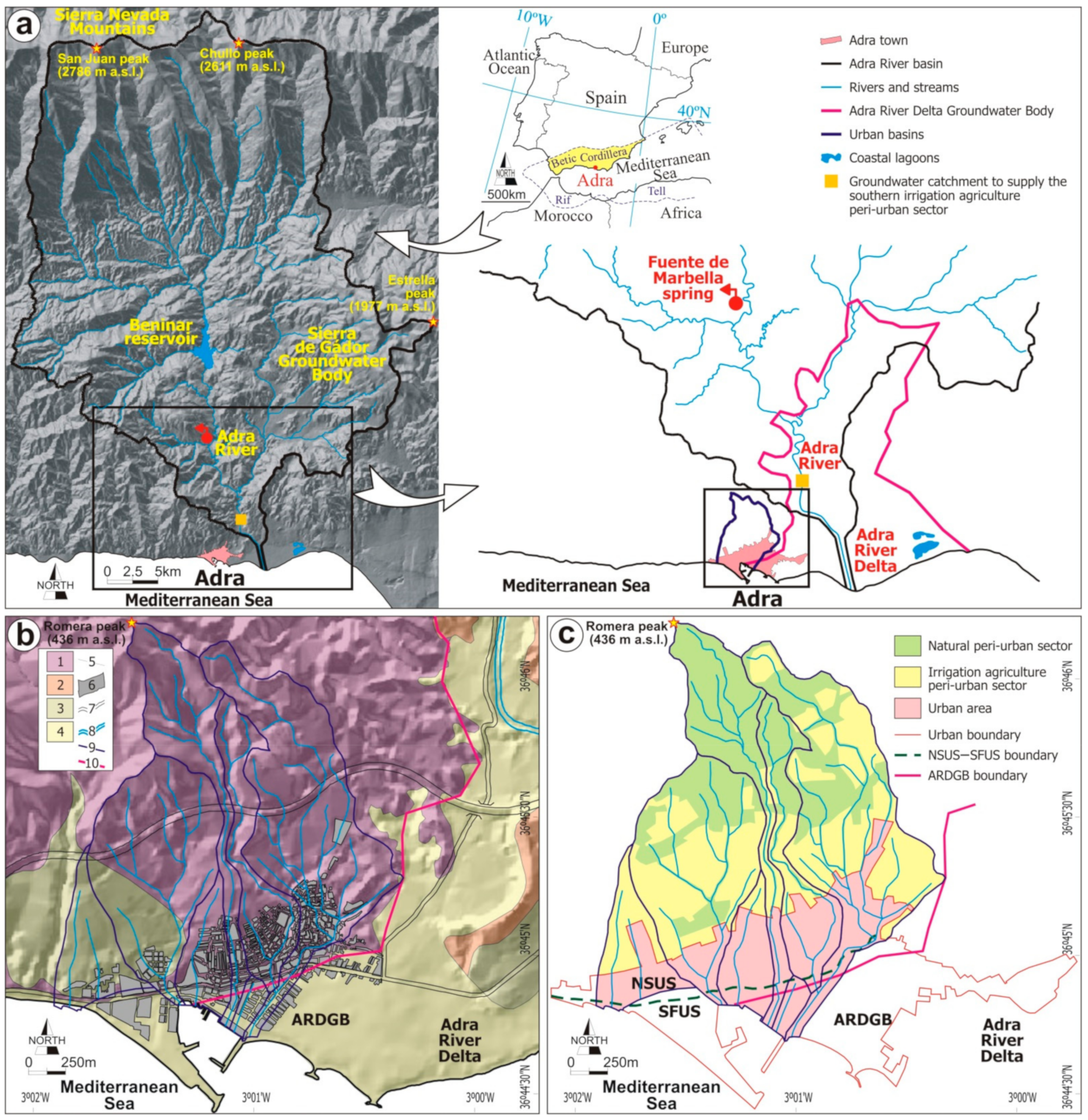
2. Study Area
2.1. Location and Climate

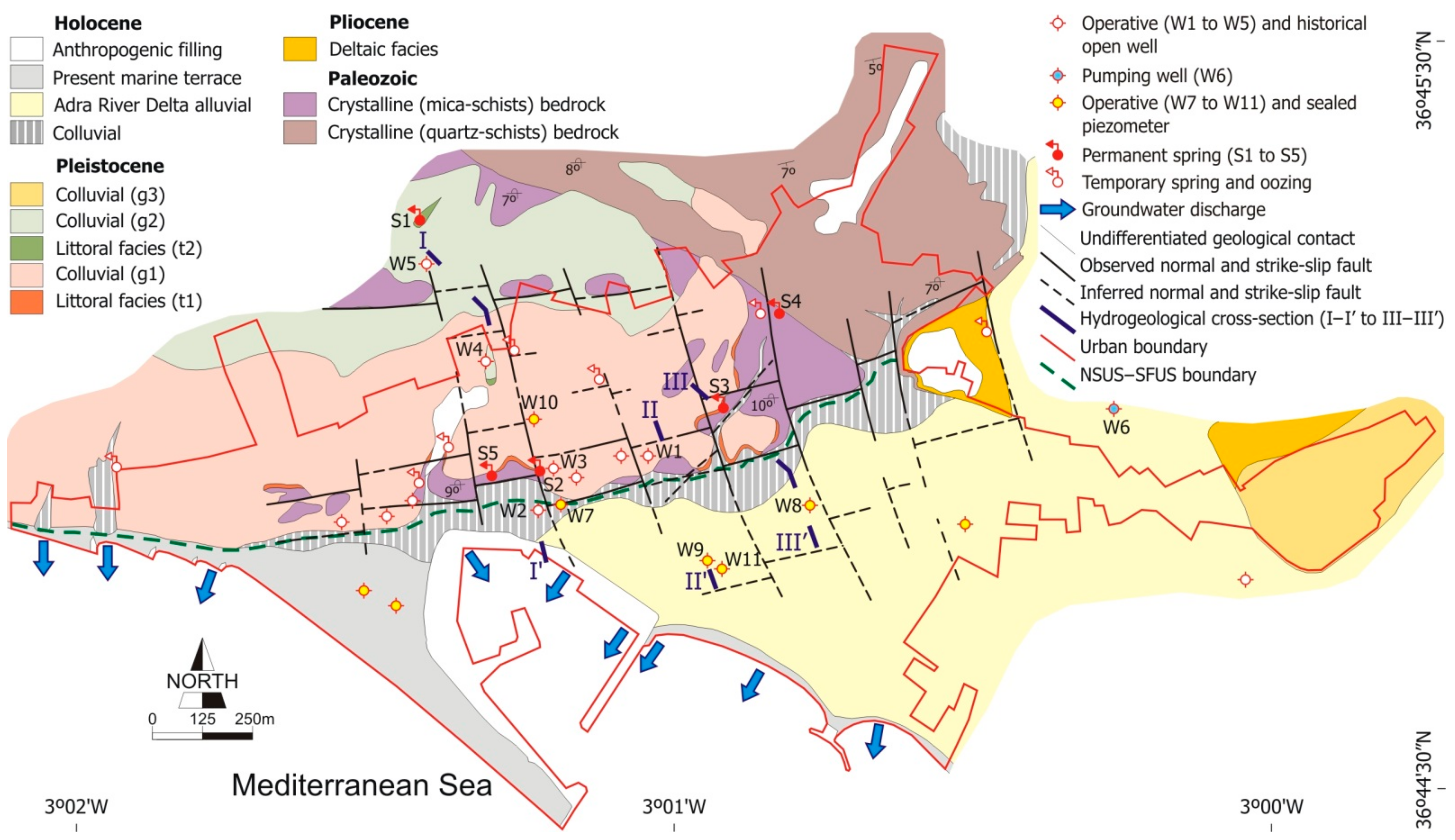
2.2. Geological and Hydrogeological Setting
2.3. Land Use and Water Allocation
3. Methods
3.1. Aquifer Geometry Definition
3.1.1. Hydrogeological Field Surveys
3.1.2. MASW Technique
3.1.3. GPR Technique
3.2. Groundwater Resource Evalution
4. Results
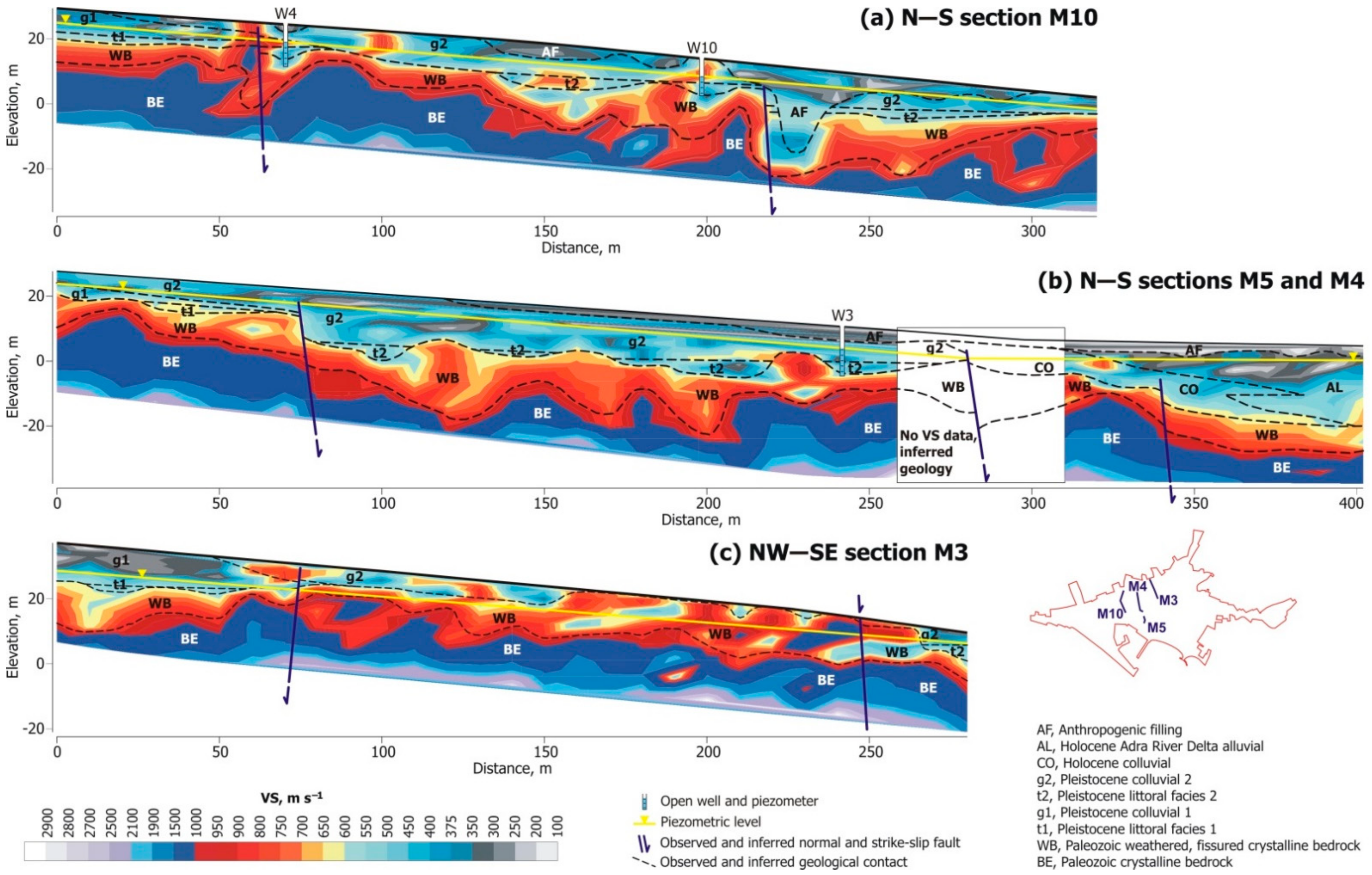
4.1. Geophysical Data
4.1.1. MASW Survey
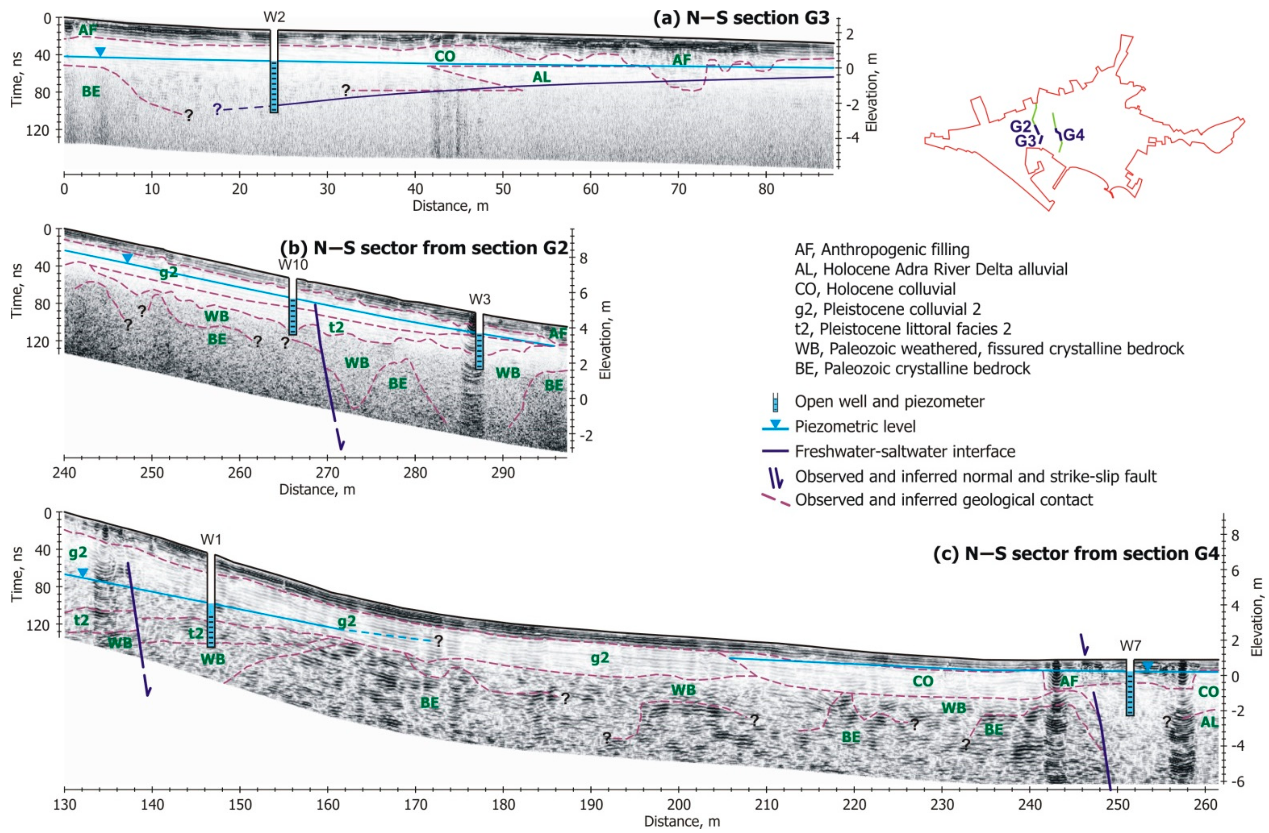
4.1.2. GPR Survey
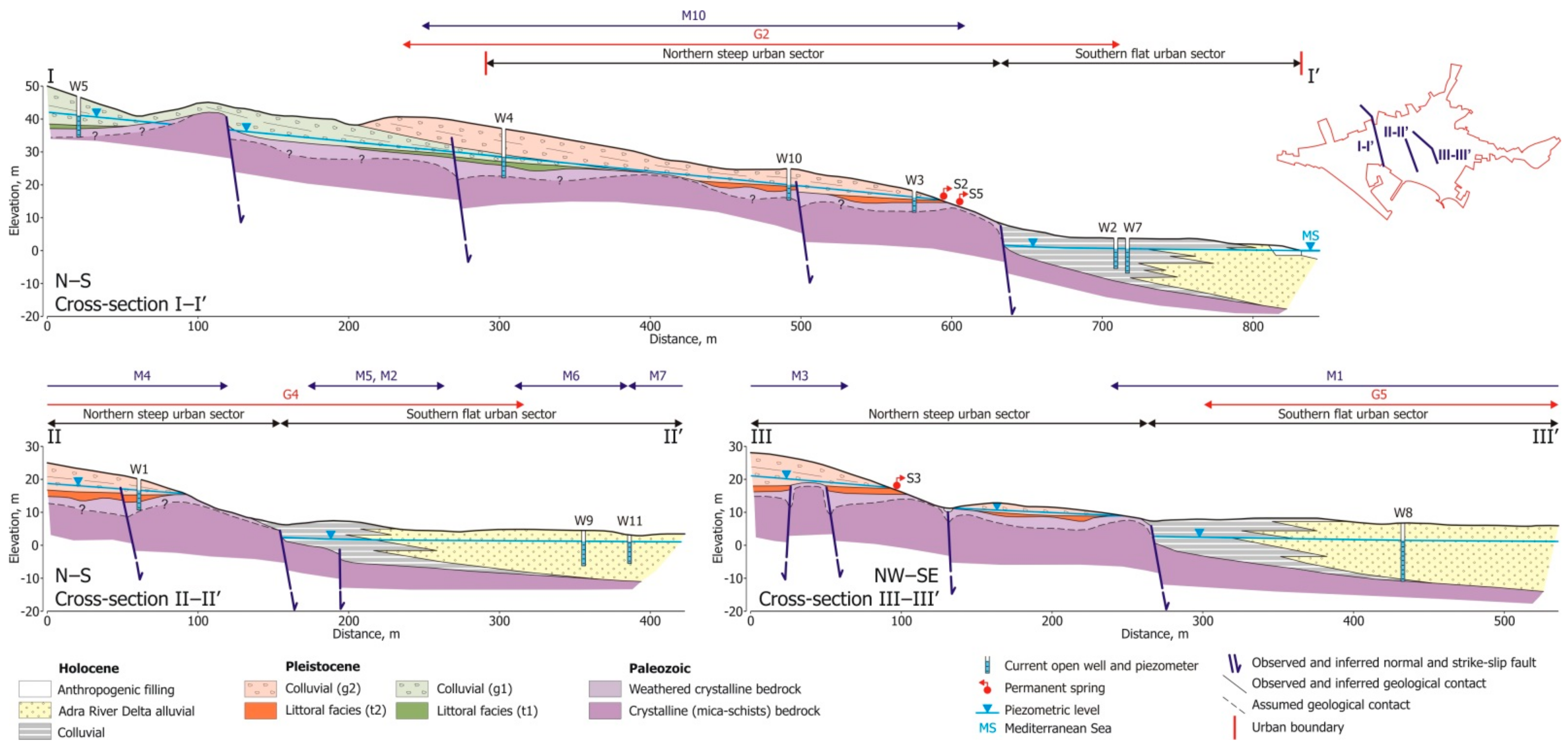
4.2. Hydrogeological Conceptualization

| Age | Hydrogeological Formation | Main Lithology | Urban Surface, km 1,2 | NSUS Surface, km 1,2 | Thickness, m 2 | Permeability, m day−1 3 | Effective Porosity, 3 | PGS in the Urban Area, Mm 3,4 | PGS in the NSUS, Mm 3,4 | Hydraulic Behavior |
|---|---|---|---|---|---|---|---|---|---|---|
| Paleozoic | Bedrock | Mica-schists, quartz-schists | 1.82 | 0.77 | – | – | – | – | – | Aquiclude |
| Weathered, fissured bedrock | Mica-schists, quartz-schists | 0.86 | 0.68 | 1–18 (8) | 0.9–1.5 (1.1) n = 3 | 0.02–0.07 (0.05) n = 3 | 0.02–1.08 (0.34) | 0.01–0.86 (0.27) | Aquifer | |
| Pliocene | Deltaic facies | Sand, gravel, silt | 0.09 | – | 4–31 (17) | 1.1–5.2 (2.9) n = 3 | 0.01–0.05 (0.02) n = 3 | <0.01–0.14 (0.03) | – | Aquifer |
| Pleistocene | Littoral facies (t1, t2) | Gravel, sand | 0.41 | 0.41 | 1–8 (4) | 2.3–9.3 (4.2) n = 4 | 0.06–0.17 (0.13) n = 4 | 0.03–0.56 (0.21) | 0.03–0.53 (0.21) | Aquifer |
| Detrital colluvial (g1, g2) | Gravel, sand, clay | 0.58 | 0.58 | 1–32 (9) | 0.05–0.09 (0.07) n = 3 | <0.01–0.01 (<0.01) n = 3 | <0.01–0.20 (0.04) | <0.01–0.20 (0.04) | Aquitard | |
| Cemented colluvial (g3) | Cemented gravel, sand | 0.10 | – | 1–29 (14) | 0.12–0.44 (0.28) n = 2 | 0.01–0.03 (0.02) n = 2 | <0.01–0.09 (0.03) | – | Aquitard | |
| Holocene | Adra River Delta alluvial | Sand, silt | 0.35 | 0.11 | 1–21 (9) | 0.8–2.9 (1.4) n = 3 | 0.05–0.10 (0.07) n = 3 | 0.02–0.74 (0.22) | <0.01–0.23 (0.07) | Aquifer |
| Present littoral facies | Sand | 0.59 | – | 1–35 (19) | 5.3–30.7 (13.8) n = 6 | 0.04–0.12 (0.07) n = 6 | 0.02–2.48 (0.78) | – | Aquifer | |
| Colluvial | Gravel, sand, clay | 0.17 | – | 1–9 (4) | 5.1–30.3 (14.5) n = 4 | 0.08–0.17 (0.13) n = 4 | 0.01–0.26 (0.09) | – | Aquifer | |
| Anthropogenic filling | Blocks, sand, silt | 0.17 | 0.05 | 1–6 (3) | 5.2–8.2 (6.7) n = 2 | 0.14–0.23 (0.17) n = 2 | 0.02–0.24 (0.09) | <0.01–0.07 (0.03) | Aquifer |
4.3. Groundwater Resource Evaluation
5. Discussion
5.1. The MASW Technique for Geological Definition
5.2. Use of the Groundwater Resource
6. Conclusions
Author Contributions
Funding
Institutional Review Board Statement
Informed Consent Statement
Data Availability Statement
Acknowledgments
Conflicts of Interest
References
- Sabater, S.; Barceló, D. Water Scarcity in the Mediterranean. Perspectives Under Global Change; Springer: Berlin/Heidelberg, Germany, 2010. [Google Scholar] [CrossRef]
- Custodio, E. Coastal aquifers of Europe: An overview. Hydrogeol. J. 2010, 18, 269–280. [Google Scholar] [CrossRef]
- Dalin, C.; Wada, Y.; Kastner, T.; Puma, M.J. Groundwater depletion embedded in international food trade. Nature 2017, 543, 700–704. [Google Scholar] [CrossRef] [PubMed]
- Custodio, E.; Andreu-Rodes, J.M.; Aragón, R.; Estrela, T.; Ferrer, J.; García-Aróstegui, J.L.; Manzano, M.; Rodríguez-Hernández, L.; Sahuquillo, A.; Del Villar, A. Groundwater intensive use and mining in south-eastern peninsular Spain: Hydrogeological, economic and social aspects. Sci. Total Environ. 2016, 559, 302–316. [Google Scholar] [CrossRef] [PubMed]
- Martínez-Valderrama, J.; Ibáñez, J.; Alcalá, F.J. AQUACOAST: A simulation tool to explore coastal groundwater and irrigation farming interactions. Sci. Program. 2020, 2020, 9092829. [Google Scholar] [CrossRef]
- Alcalá, F.J.; Martínez-Valderrama, J.; Robles-Marín, P.; Guerrera, F.; Martín-Martín, M.; Raffaelli, G.; Tejera de León, J.; Asebriy, L. A hydrological-economic model for sustainable groundwater use in sparse-data drylands: Application to the Amtoudi Oasis in southern Morocco, northern Sahara. Sci. Total Environ. 2015, 537, 309–322. [Google Scholar] [CrossRef]
- Alcalá, F.J.; Martín-Martín, M.; Guerrera, F.; Martínez-Valderrama, J.; Robles-Marín, P. A feasible methodology for groundwater resource modelling for sustainable use in sparse-data drylands: Application to the Amtoudi Oasis in the northern Sahara. Sci. Total Environ. 2018, 630, 1246–1257. [Google Scholar] [CrossRef]
- Morote, Á.F.; Olcina, J.; Rico, A.M. Challenges and proposals for socio-ecological sustainability of the tagus–segura aqueduct (Spain) under climate change. Sustainability 2017, 9, 2058. [Google Scholar] [CrossRef]
- Morote, Á.F.; Olcina, J.; Hernández, M. The use of non-conventional water resources as a means of adaptation to drought and climate change in Semi-Arid Regions: South-Eastern Spain. Water 2019, 11, 93. [Google Scholar] [CrossRef]
- Licciardello, F.; Milani, M.; Consoli, S.; Pappalardo, N.; Barbagallo, S.; Cirelli, G. Wastewater tertiary treatment options to match reuse standards in agriculture. Agric. Water Manag. 2018, 210, 232–242. [Google Scholar] [CrossRef]
- Allam, A.R.; Saaf, E.J.; Dawoud, M.A. Desalination of brackish groundwater in Egypt. Desalination 2002, 152, 19–26. [Google Scholar] [CrossRef]
- Alcalá, F.J. Usefulness of the Cl/Br ratio to identify the effect of reverse osmosis treated waters on groundwater systems. Desalination 2019, 470, 114102. [Google Scholar] [CrossRef]
- Downward, S.R.; Taylor, R. An assessment of Spain’s Programa AGUA and its implications for sustainable water management in the province of Almería, southeast Spain. J. Environ. Manag. 2007, 82, 277–289. [Google Scholar] [CrossRef]
- Rodríguez-Rodríguez, M.; Benavente, J.; Alcalá, F.J.; Paracuellos, M. Long-term water monitoring in two Mediterranean lagoons as an indicator of land-use changes and intense precipitation events (Adra, Southeastern Spain). Estuar. Coast. Shelf Sci. 2011, 91, 400–410. [Google Scholar] [CrossRef]
- Alcalá, F.J.; Solé, A.; Creus, C.; Domingo, F. Aporte urbano de agua subterránea hacia masas hídricas regionales y ecosistemas dependientes. Caso de la localidad costera de Adra (SE de España). In VII Simposio del Agua en Andalucía, 1st ed.; López-Geta, J.A., Rubio, J.C., Martín-Machuca, M., Eds.; Geological Survey of Spain: Madrid, Spain, 2008; Volume 2, pp. 699–708. [Google Scholar]
- Poeter, E.; Anderson, D. Multimodel ranking and inference in ground water modeling. Groundwater 2005, 43, 597–605. [Google Scholar] [CrossRef]
- Hojberg, A.L.; Refsgaard, J.C. Model uncertainty-parameter uncertainty versus conceptual models. Water Sci. Technol. 2005, 52, 177–186. [Google Scholar] [CrossRef]
- Beven, K. Towards integrated environmental models of everywhere: Uncertainty, data and modelling as a learning process. Hydrol. Earth Syst. Sci. 2007, 11, 460–467. [Google Scholar] [CrossRef]
- Alcalá, F.J.; Espinosa, J.; Navarro, M.; Sánchez, F.J. Propuesta de división geológica de la localidad de Adra (provincia de Almería). Aplicación a la zonación sísmica. Rev. Soc. Geológica España 2002, 15, 55–66. [Google Scholar]
- Monteiro Santos, F.A.; Sultan, S.A.; Represas, P.; El Sorady, A.L. Joint inversion of gravity and geoelectric data for groundwater and structural investigation: Application to the northwestern part of Sinai, Egypt. Geophys. J. Int. 2006, 165, 705–718. [Google Scholar] [CrossRef]
- Khalil, M.A.; Hafez, M.A.; Santos, F.M.; Ramalho, E.C.; Mesbah, H.S.; El-Qady, G.M. An approach to estimate porosity and groundwater salinity by combined application of GPR and VES: A case study in the Nubian sandstone aquifer. Near Surf. Geophys. 2010, 8, 223–233. [Google Scholar] [CrossRef]
- Alam, K.; Ahmad, N. Determination of aquifer geometry through geophysical methods: A case study from Quetta Valley, Pakistan. Acta Geophys. 2014, 62, 142–163. [Google Scholar] [CrossRef]
- Farzamian, M.; Monteiro Santos, F.A.; Khalil, M.A. Estimation of unsaturated hydraulic parameters in sandstone using electrical resistivity tomography under a water injection test. J. Appl. Geophys. 2015, 121, 71–83. [Google Scholar] [CrossRef]
- Binley, A.; Hubbard, S.S.; Huisman, J.A.; Revil, A.; Robinson, D.A.; Singha, K.; Slater, L.D. The emergence of hydrogeophysics for improved understanding of subsurface processes over multiple scales. Water Resour. Res. 2015, 51, 3837–3866. [Google Scholar] [CrossRef] [PubMed]
- Gonçalves, R.; Farzamian, M.; Monteiro Santos, F.A.; Represas, P.; Mota Gomes, A.; Lobo de Pina, A.F.; Almeida, E.P. Application of time-domain electromagnetic method in investigating saltwater intrusion of Santiago Island (Cape Verde). Pure Appl. Geophys. 2017, 174, 4171–4182. [Google Scholar] [CrossRef]
- Giustiniani, M.; Accaino, F.; Picotti, S.; Tinivella, U. Characterization of the shallow aquifers by high-resolution seismic data. Geophys. Prospect. 2008, 56, 655–666. [Google Scholar] [CrossRef]
- Martorana, R.; Lombardo, L.; Messina, N.; Luzio, D. Integrated geophysical survey for 3D modelling of a coastal aquifer polluted by seawater. Near Surf. Geophys. 2014, 12, 45–59. [Google Scholar] [CrossRef]
- Foti, S.; Hollender, F.; Garofalo, F.; Albarello, D.; Asten, M.; Bard, P.Y.; Comina, C.; Cornou, C.; Cox, B.; Giulio, G.D.; et al. Guidelines for the good practice of surface wave analysis: A product of the InterPACIFIC project. Bull. Earthq. Eng. 2018, 16, 2367–2420. [Google Scholar] [CrossRef]
- Xia, J.; Miller, R.D.; Park, C.B. Estimation of near-surface shear-wave velocity by inversion of Rayleigh wave. Geophysics 1999, 64, 691–700. [Google Scholar] [CrossRef]
- Xia, J.; Miller, R.D.; Park, C.B.; Hunter, J.A.; Harris, J.B.; Ivanov, J. Comparing shear-wave velocity profiles inverted from multichannel surface wave with borehole measurements. Soil Dyn. Earthq. Eng. 2002, 22, 181–190. [Google Scholar] [CrossRef]
- Park, C.B.; Miller, R.D.; Xia, J. Multi-channel analysis of surface waves. Geophysics 1999, 64, 800–808. [Google Scholar] [CrossRef]
- Park, C.B.; Miller, R.D.; Xia, J.; Ivanov, J. Multichannel analysis of surface waves (MASW)—Active and passive methods. Lead Edge 2007, 26, 60–64. [Google Scholar] [CrossRef]
- Paz, C.; Alcalá, F.J.; Carvalho, J.M.; Ribeiro, L. Current uses of ground penetrating radar in groundwater-dependent ecosystems research. Sci. Total Environ. 2017, 595, 868–885. [Google Scholar] [CrossRef]
- Bobeck, P. Henry Darcy in his own words. Hydrogeol. J. 2006, 14, 998–1004. [Google Scholar] [CrossRef]
- Brown, G.O. Henry Darcy and the making of a law. Water Resour. Res. 2002, 38, 1106. [Google Scholar] [CrossRef]
- Chen, D.; Chen, H.W. Using the Köppen classification to quantify climate variation and change: An example for 1901–2010. Environ. Dev. 2013, 6, 69–79. [Google Scholar] [CrossRef]
- Herrera, S.; Cardoso, R.M.; Soares, P.M.M.; Espírito–Santo, F.; Viterbo, P.; Gutiérrez, J.M. Iberia01: A new gridded dataset of daily precipitation and temperatures over Iberia. Earth Syst. Sci. Data 2019, 11, 1947–1956. [Google Scholar] [CrossRef]
- IGME. Geological Map of Spain, Scale 1:50,000; Sheet nº 1057 Adra. Geological Survey of Spain, Memory and Maps; IGME: Madrid, Spain, 1983; Available online: http://info.igme.es/cartografiadigital/geologica/Magna50.aspx (accessed on 11 January 2021).
- Sanz de Galdeano, C. La Zona Interna Bético-Rifeña. Antecedentes, Unidades Tectónicas, Correlaciones y Bosquejo de Reconstrucción Paleogeográfica; University of Granada: Granada, Spain, 1997; pp. 1–316. [Google Scholar]
- Alcalá, F.J.; Guerrera, F.; Martín-Martín, M.; Raffaelli, G.; Serrano, F. Geodynamic implications derived from Numidian-like distal turbidites deposited along the Internal-External Domain Boundary of the Betic Cordillera (S, Spain). Terra Nova 2013, 25, 119–129. [Google Scholar] [CrossRef]
- Goy, J.L.; Zazo, C. Synthesis of the Quaternary in the Almería littoral neotectonic activity and its morphologic features, western Betics, Spain. Tectonophysics 1986, 130, 259–270. [Google Scholar] [CrossRef]
- Pulido-Bosch, A.; Morales, G.; Benavente, J. Hidrogeología del delta del río Adra. Estud. Geológicos 1988, 44, 429–443. [Google Scholar] [CrossRef]
- IGME. Hydrogeological Map of Spain, Scale 1:200,000; Sheet nº 84, Almería; Geological Survey of Spain, Memory and Maps; IGME: Madrid, Spain, 1988; Available online: http://info.igme.es/cartografiadigital/tematica/Hidrogeologico200.aspx (accessed on 11 January 2021).
- IGME. Hydrogeological Atlas of Andalusia. Geological Survey of Spain; IGME: Madrid, Spain, 1998; Available online: https://aguas.igme.es/igme/publica/libros1_HR/libro110/lib110.htm (accessed on 11 January 2021).
- INE. Official Population Figures of Spanish Municipalities: Review of the Municipal Register—Population at 01 January 2019; Spanish National Institute for Statistics: Madrid, Spain, 2019; Available online: https://www.ine.es/jaxiT3/Datos.htm?t=2857#!tabs-tabla (accessed on 29 December 2020).
- JUNTA. Hydrographic Demarcation of the Andalusian Mediterranean Basins—Appendix III: Uses and Demands; Ministry of Agriculture, Fishery and Environment, Government of Andalusia: Sevilla, Spain, 2015; pp. 1–133.
- CENTER. Evaluation of the San Fernando Canal Irrigation Community. Municipal district of Adra (Almería); Ministry of Agriculture, Fishery and Feeding, Government of Spain: Madrid, Spain, 2007; pp. 1–161.
- Alcalá, F.J.; Zapata, A.; Morillas-Arcos, M. Estructuras de detención/retención en la localidad de Adra (Almería). Posible alternativa al aprovechamiento de aguas pluviales. In V Simposio Sobre el Agua en Andalucía, 1st ed.; Pulido-Bosch, A., Pulido-Leboeuf, P.A., Vallejos-Izquierdo, A., Eds.; University of Almería: Almería, Spain, 2001; Volume 1, pp. 143–154. [Google Scholar]
- ARWUA. Groundwater Balance of the Adra River Alluvial Aquifer at Los Hurtados-Las Checas Place (Adra, Almería); Memory and Appendices; Adra River Water Users Association: Adra, Spain, 2007. [Google Scholar]
- CSIC. Scientific-Technical Advice to Study the Hydrogeological Ground Behavior on the Site and Neighbouring to the San Andrés III and San Andrés IV Buildings, Located at 12 and 14 Portón Street, in Adra Town (Almería); Memory and Appendices; Spanish National Research Council: Almería, Spain, 2010. [Google Scholar]
- Benavente, J.; Castillo, A. Estudio Hidrogeoquímico de la cuenca del río Adra. Estud. Geológicos 1989, 45, 81–90. [Google Scholar] [CrossRef]
- González-López, J. Water Resources Evaluation of the Adra River Valley Alluvial Aquifer, Almería Province. Bachelor’s Thesis, Catholic University of Murcia, Murcia, Spain, 2015. [Google Scholar]
- Martínez-Pagán, P.; Navarro, M.; Pérez-Cuevas, J.; Alcalá, F.J.; García-Jerez, A.; Vidal, F. Shear-wave velocity structure from MASW and SPAC methods. The case of Adra town, SE Spain. Near Surf. Geophys. 2018, 16, 356–371. [Google Scholar] [CrossRef]
- Lunt, I.A.; Hubbard, S.S.; Rubin, Y. Soil moisture content estimation using ground penetrating radar reflection data. J. Hydrol. 2015, 307, 254–269. [Google Scholar] [CrossRef]
- Annan, A.P. GPR—History, trends, and future developments. Subsurf. Sens. Technol. Appl. 2002, 3, 253–270. [Google Scholar] [CrossRef]
- Beres, M.; Haeni, F.P. Application of ground-penetrating radar methods in hydrogeologic studies. Ground Water 1991, 29, 375–386. [Google Scholar] [CrossRef]
- Cassidy, N.J. Electrical and magnetic properties of rocks, soils and fluids. In Ground Penetrating Radar: Theory and Applications, 1st ed.; Jol, H.M., Ed.; Elsevier: Amsterdam, The Netherlands, 2009; pp. 41–72. [Google Scholar]
- Neal, A. Ground penetrating radar and its use in sedimentology: Principles, problems and progress. Earth-Sci. Rev. 2004, 66, 261–330. [Google Scholar] [CrossRef]
- Bano, M.; Marquis, G.; Nivière, B.; Maurin, J.C.; Cushing, M. Investigating alluvial and tectonic features with ground-penetrating radar and analyzing diffractions patterns. J. Appl. Geophys. 2000, 43, 33–41. [Google Scholar] [CrossRef]
- Paz, C.; Alcalá, F.J.; Ribeiro, L. Ground penetrating radar attenuation expressions in shallow groundwater research. J. Environ. Eng. Geophys. 2020, 25, 153–160. [Google Scholar] [CrossRef]
- Van Dam, R.L.; Schlager, W. Identifying causes of ground-penetrating radar reflections using time-domain reflectometry and sedimentological analyses. Sedimentology 2000, 47, 435–449. [Google Scholar] [CrossRef]
- Paz, M.C.; Alcalá, F.J.; Medeiros, A.; Martínez-Pagán, P.; Pérez-Cuevas, J.; Ribeiro, L. Integrated MASW and ERT imaging for geological definition of an unconfined alluvial aquifer sustaining a coastal groundwater-dependent ecosystem in southwest Portugal. Appl. Sci. 2020, 10, 5905. [Google Scholar] [CrossRef]
- García-Jerez, A.; Navarro, M.; Alcalá, F.J.; Luzón, F.; Pérez-Ruiz, J.A.; Enomoto, T.; Vidal, F.; Ocaña, E. Shallow velocity structure using joint inversion of array and h/v spectral ratio of ambient noise: The case of Mula town (SE of Spain). Soil Dyn. Earthq. Eng. 2007, 27, 907–919. [Google Scholar] [CrossRef]
- Mitchell, J.K.; Soga, K. Fundamentals of Soil Behaviour, 3rd ed.; Wiley: London, UK, 2005; pp. 1–592. [Google Scholar]
- Zimmer, M.A.; Prasad, M.; Mavko, G.; Nur, A. Seismic velocities of unconsolidated sands: Part 1—Pressure trends from 0.1 to 20 MPa. Geophysics 2007, 72, E1–E13. [Google Scholar] [CrossRef]
- McGann, C.R.; Bradley, B.A.; Cubrinovski, M. Investigation of shear wave velocity depth variability, site classification, and liquefaction vulnerability identification using a near-surface Vs model of Christchurch, New Zealand. Soil Dyn. Earthq. Eng. 2017, 92, 692–705. [Google Scholar] [CrossRef]
- Navarro, M.; Vidal, F.; Enomoto, T.; Alcalá, F.; García-Jerez, A.; Sánchez, F.J.; Abeki, N. Analysis of the weightiness of site effects on reinforced concrete (RC) building seismic behavior. The Adra town example (SE Spain). Earthq. Eng. Struct. Dyn. 2007, 36, 1363–1383. [Google Scholar] [CrossRef]
- Andreu, J.M.; Alcalá, F.J.; Vallejos, Á.; Pulido-Bosch, A. Recharge to aquifers in SE Spain: Different approaches and new challenges. J. Arid Environ. 2011, 75, 1262–1270. [Google Scholar] [CrossRef]
- Martínez-Pagán, P.; Navarro, M.; Pérez-Cuevas, J.; Alcalá, F.J.; García-Jerez, A.; Sandoval-Castaño, S. Shear-wave velocity based seismic microzonation of Lorca city (SE Spain) from MASW analysis. Near Surf. Geophys. 2014, 12, 739–749. [Google Scholar] [CrossRef]
- Lerner, D.N. Identifying and quantifying urban recharge: A review. Hydrogeol. J. 2002, 10, 143–152. [Google Scholar] [CrossRef]
- Vázquez-Suñé, E.; Sánchez-Vila, X.; Carrera, J. Introductory review of specific factors influencing urban groundwater, an emerging branch of hydrogeology, with reference to Barcelona, Spain. Hydrogeol. J. 2004, 13, 522–533. [Google Scholar] [CrossRef]
- Schirmer, M.; Leschik, S.; Musolff, A. Current research in urban hydrogeology—A review. Adv. Water Resour. 2013, 51, 280–291. [Google Scholar] [CrossRef]
- Asebriy, L.; Cherkaoui, T.; El Amrani-El Hassani, I.; Franchi, R.; Guerrera, F.; Martín-Martín, M.; Guerrera-Patamìa, C.; Raffaelli, G.; Robles-Marín, P.; Tejera de León, J.; et al. Deterioration processes on archaeological sites of Chellah and Oudayas (world cultural heritage, Rabat, Morocco): Restoration test and recommendations. Ital. J. Geosci. 2009, 128, 157–171. [Google Scholar]
- Luberti, G.M.; Vergar, F.; Marin, R.; Pica, A.; Del Monte, M. Anthropogenic modifications to the drainage network of Rome (Italy): The case study of the Aqua Mariana. Alp. Mediterr. Quat. 2018, 31, 119–132. [Google Scholar]
- Forno, M.G.; De Luca, D.; Bonasera, M.; Bucci, A.; Gianotti, F.; Lasagna, M.; Lucchesi, S.; Pelizza, S.; Piana, F.; Taddia, G. Synthesis on the Turin subsoil stratigraphy and hydrogeology (NW Italy). Alp. Mediterr. Quat. 2018, 31, 147–170. [Google Scholar]
- Alcalá, F.J.; Cantón, Y.; Contreras, S.; Were, A.; Serrano-Ortiz, P.; Puigdefábregas, J.; Solé-Benet, A.; Custodio, E.; Domingo, F. Diffuse and concentrated recharge evaluation using physical and tracer techniques: Results from a semiarid carbonate massif aquifer in southeast Spain. Environ. Earth Sci. 2011, 62, 541–557. [Google Scholar] [CrossRef]
- Pulido-Velazquez, D.; Romero, J.; Collados-Lara, A.J.; Alcalá, F.J.; Fernández-Chacón, F.; Baena-Ruiz, L. Using the turnover time index to identify potential strategic groundwater resources to manage droughts within continental Spain. Water 2020, 12, 3281. [Google Scholar] [CrossRef]


| Acronym | Description |
|---|---|
| AGS | Actual groundwater storage |
| ARB | Adra River basin |
| ARD | Adra River Delta |
| ARDGB | Adra River Delta Groundwater Body |
| g1 | Pleistocene colluvial 1 |
| g2 | Pleistocene colluvial 2 |
| g3 | Pleistocene colluvial 3 |
| GDE | Groundwater-dependent ecosystem |
| GPR | Ground Penetrating Radar |
| MASW | Multichannel Analysis of Surface Waves |
| NSUS | Northern steep urban sector |
| PGS | Potential groundwater storage |
| SFUS | Southern flat urban sector |
| t1 | Pleistocene littoral facies 1 |
| t2 | Pleistocene littoral facies 2 |
| VE | Velocity of electromagnetic waves |
| VS | Shear-wave velocity |
| WB | Paleozoic weathered, fissured crystalline bedrock |
| Hydrogeological Formation 1 | i2 | K2 | b2 | l2 | D2 | AGS2 |
|---|---|---|---|---|---|---|
| Weathered, fissured bedrock | 0.035 | 0.9–1.5 (1.1) n = 3 | 0.8–15.3 (6.8) | 1860 | 0.02–0.55 (0.18) | 0.01–0.73 (0.23) |
| Littoral facies (t1, t2) | 0.035 | 2.3–9.3 (4.2) n = 4 | 0.8–6.8 (3.4) | 450 | 0.01–0.36 (0.08) | 0.02–0.47 (0.18) |
| Detrital colluvial (g1, g2) | 0.035 | 0.05–0.09 (0.07) n = 3 | 0.5–16.0 (4.5) | 1610 | <0.01–0.03 (<0.01) | <0.01–0.10 (0.02) |
| Colluvial | 0.017 | 0.8–2.9 (1.4) n = 3 | 0.6–12.6 (5.4) | 480 | <0.01–0.11 (0.02) | <0.01–0.14 (0.04) |
| Anthropogenic filling | 0.004 | 5.2–8.2 (6.7) n = 2 | 0.5–3.0 (1.5) | 110 | <0.01 | <0.01–0.03 (0.01) |
| Recharge Component | Area Covered 1 | Surface, km2 | Recharge, Mm3 year−1 | Reference |
|---|---|---|---|---|
| Precipitation | PUA, NSUS | 3.41 | 0.03 | [15] |
| Urban return | NSUS | 0.77 | 0.10 | [46] |
| Irrigation return | SPUS | 1.41 | 0.17 | [47] |
Publisher’s Note: MDPI stays neutral with regard to jurisdictional claims in published maps and institutional affiliations. |
© 2021 by the authors. Licensee MDPI, Basel, Switzerland. This article is an open access article distributed under the terms and conditions of the Creative Commons Attribution (CC BY) license (https://creativecommons.org/licenses/by/4.0/).
Share and Cite
Alcalá, F.J.; Martínez-Pagán, P.; Paz, M.C.; Navarro, M.; Pérez-Cuevas, J.; Domingo, F. Combining of MASW and GPR Imaging and Hydrogeological Surveys for the Groundwater Resource Evaluation in a Coastal Urban Area in Southern Spain. Appl. Sci. 2021, 11, 3154. https://doi.org/10.3390/app11073154
Alcalá FJ, Martínez-Pagán P, Paz MC, Navarro M, Pérez-Cuevas J, Domingo F. Combining of MASW and GPR Imaging and Hydrogeological Surveys for the Groundwater Resource Evaluation in a Coastal Urban Area in Southern Spain. Applied Sciences. 2021; 11(7):3154. https://doi.org/10.3390/app11073154
Chicago/Turabian StyleAlcalá, Francisco Javier, Pedro Martínez-Pagán, Maria Catarina Paz, Manuel Navarro, Jaruselsky Pérez-Cuevas, and Francisco Domingo. 2021. "Combining of MASW and GPR Imaging and Hydrogeological Surveys for the Groundwater Resource Evaluation in a Coastal Urban Area in Southern Spain" Applied Sciences 11, no. 7: 3154. https://doi.org/10.3390/app11073154
APA StyleAlcalá, F. J., Martínez-Pagán, P., Paz, M. C., Navarro, M., Pérez-Cuevas, J., & Domingo, F. (2021). Combining of MASW and GPR Imaging and Hydrogeological Surveys for the Groundwater Resource Evaluation in a Coastal Urban Area in Southern Spain. Applied Sciences, 11(7), 3154. https://doi.org/10.3390/app11073154