Article

Magmatic Geothermal Genesis Model in the Huailai Area Based on the Constraints of the Crust–Mantle-Scale Geoelectric Structure

1
College of Geoexploration Science and Technology, Jilin University, Changchun 130026, China
2
Key Laboratory of Applied Geophysics, Jilin University, Changchun 130026, China
3
School of Geophysics and Measurement-Control Technology, East China University of Technology, Nanchang 330013, China
*
Author to whom correspondence should be addressed.
Appl. Sci. 2021, 11(5), 2086; https://doi.org/10.3390/app11052086
Submission received: 10 December 2020 / Revised: 12 February 2021 / Accepted: 23 February 2021 / Published: 26 February 2021
(This article belongs to the Special Issue Seismic Exploration and Geothermal Energy)

Abstract

:
The Huailai area is rich in geothermal resources, but the formation mechanism of its deep heat source is still unclear. In this paper, based on 16 broadband magnetotelluric sounding points, the two-dimensional electrical structure of the crust and mantle in the Huailai area was obtained. Combined with deep seismic reflection and P-wave seismic tomography, the geophysical characteristics of deep heat sources and reservoirs in the Huailai area are described. The Huailai area is characterized by low resistivity and layered reflection above 2 km in depth, which shows the distribution of the Cenozoic sedimentary cover layer. The upper crust is characterized by high resistivity without an obvious reflector, corresponding to the crystalline basement of the basin, whose main lithology is Archean gneiss. There is a highly conductive and bright-spot-reflective structure under the basement, which extends to 100 km, indicating the upwelling of mantle-derived material. Combined with the results of helium isotope tracing, a magma-type geothermal model in the Huailai area is proposed. The upwelling mantle-derived magma material is enriched under the basement to form a heat source. The heat is transferred to the upper crust through heat conduction along the crystalline basement. Then, groundwater circulation brings deep heat to the surface, forming hydrothermal resources.

1. Introduction

The Huailai area is located on the southern margin of the Yan Mountain fold belt, the northern margin of the Taihang Mountain uplift, the Xuanhua Basin in the northwest, and the Fanshan Basin in the southeast (Figure 1). It is rich in geothermal resources, such as the Xijiabao, Houhaoyao, and Nuanquan hot springs, among others. Hot spring water in the area has medium to low temperature (<80 °C), but the temperature of deeper hot water can reach up to 120 °C [1,2], which is closely related to the occurrence of earthquakes [3,4]. The circulation depth of the geothermal water is generally greater than 2 km, which is categorized as the deep circulation type [5]. According to the viewpoint of plate tectonics, the heat source is deeper, and the primary task of studying this kind of geothermal system is to determine the origin of the heat source [6].
Based on the formation types of heat sources, geothermal systems can be roughly divided into magmatic and non-magmatic. The magmatic geothermal system is formed by magma, with a relatively simple structure: the upper layer is caprock, composed of high-conductivity clay and calcareous cement, and the lower layer is thermal storage, with relatively high resistance. Groundwater continuously circulates between the caprock and thermal reservoirs to form hot water. Non-magmatic geothermal systems are different in structure and composition [7]. According to hydrogeological surveys, most geothermal water in the Huailai area is mainly distributed in bedrock and the overlying strata, and there are clay and calcareous cements in the upper caprock [8], which conforms to the shallow characteristics of the magmatic geothermal type. However, there has been no Cenozoic volcanic activity or tectonic movement that may lead to magmatism in the Huailai area or the adjacent areas. No clear conclusion exists about the formation mechanism of the heat source. Based on the heat transfer mode, the geothermal system in the Huailai area was classified as convective [9]. One view was that this type of geothermal system has no additional heat source, and is instead supplied by normal or high regional geothermal flow, and that the heat storage temperature is proportional to the circulation depth [1]. Another view is that the heat source is radioactive, generated in the bedrock granite [10], but this lacks relevant evidence. However, helium isotope studies have shown that there is a considerable amount of mantle-derived helium in hot spring water, implying that the formation of deep heat sources is related to the upwelling of mantle-derived materials [2,11]. Seismic reflections have also provided evidence of magma intrusion in the Huailai area [12,13,14], but there is insufficient evidence to show that it is related to the formation of a geothermal system. Related hydrogeological research only involved the movement and storage of groundwater above the basement [8] and lacked considerations of deep heat sources and structural support. To explore the genetic model and establish a complete model of the geothermal system in the Huailai area, the types of deep heat sources and the structure of the crust and mantle must be identified.
Electrical surveying is an important means of investigating geothermal systems. The conductivity of rocks is closely related to the abundance of water and temperature [15]. The rocks rich in geothermal water usually have lower resistivity than dry rocks and are generally connected to the structural fracture zone of the deep heat source [16]. Water-abundant and fractured zones usually have high conductivity. The magnetotelluric sounding method (MT) has a very sensitive response to high conductors, and its resolution can range from tens of meters to hundreds of kilometers. Combined with relevant regional geological conditions, the MT is effective in the exploration of geothermal systems [17,18,19,20,21,22].
In this study, we used the MT combined with seismic and hydrochemical constraints to further explore the geothermal characteristics of the Huailai area. We aimed to reveal the deep genesis of the geothermal system in the Huailai area and to establish a complete conceptual model of the geothermal system.

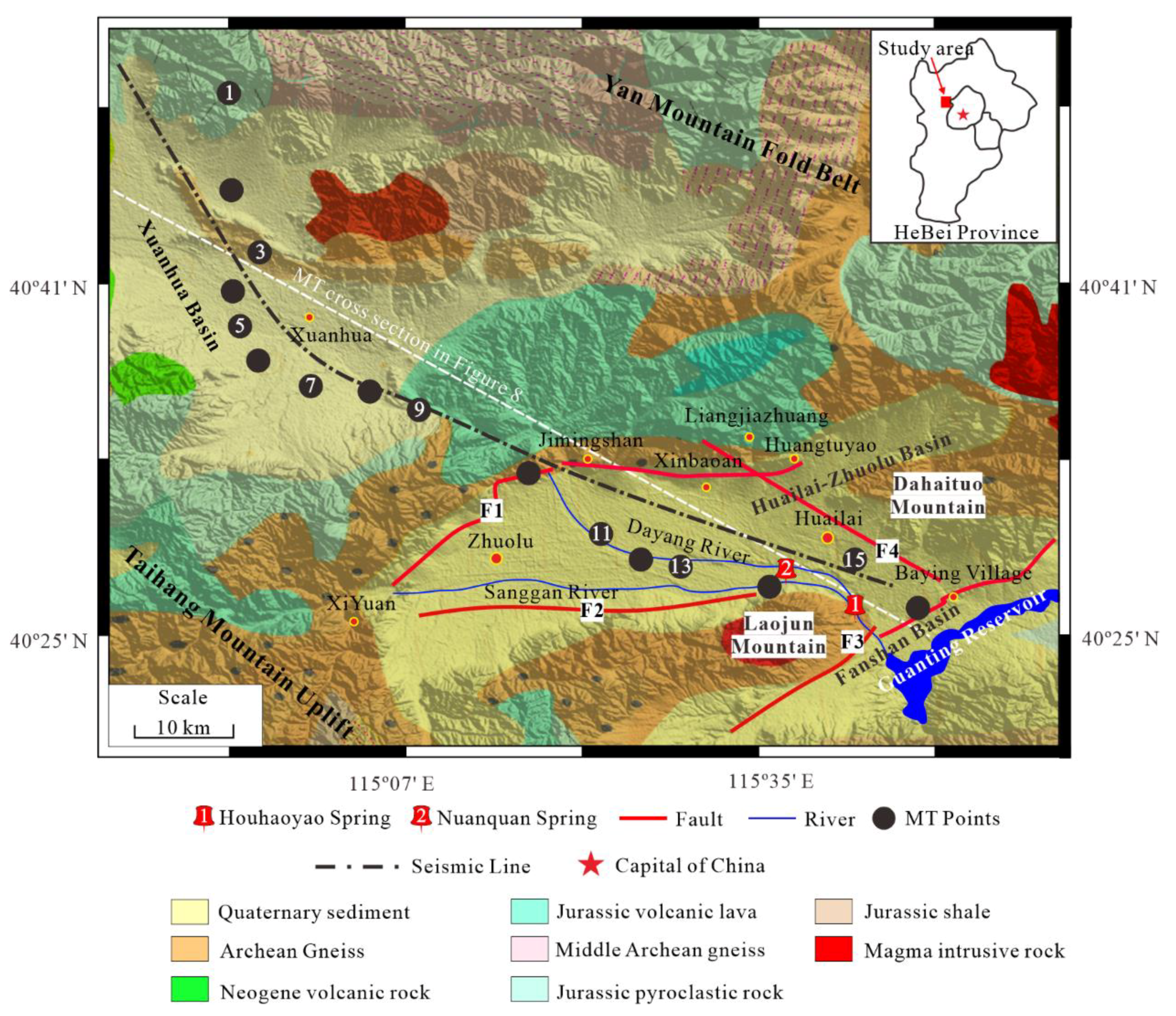
2. Geological Overview in the Huailai Area

2.1. Regional Geology of the Huailai Area

The Huailai Basin is a Cenozoic fault basin, controlled by NW extensional tectonic stress. The basement consists of pre-Sinian schist and Archean gneiss [23]. The thickness of the sedimentary caprock above the basement can reach 2 km [13]. Inside the basin, the main exposed stratum is the Quaternary sedimentary layer; outside the basin, a larger amount of Archean gneiss, Jurassic volcanic lava, and pyroclastic rock is exposed, and a small amount of intrusive rocks is interspersed, which reflects the regional tectonic and magmatic activity. There are four main faults in the basin, which are closely related to the formation of the geothermal system. The fault (F1) on the northern margin of Huaizhuo basin originates from Xiyuan, through Jimingshan and Xinbaoan, and ends near Huangtuyao. It is a normal fault that controls sedimentation activity in the Huailai Basin [24]. The Sanggan River hidden fault (F2) is distributed along the Sanggan River valley in the east–west direction and stops near the Nuanquan hot spring [25], and its activity is not obvious [26]. The northern margin fault of the Fanshan Basin (F3) runs along the southern margin of Laojun Mountain, passes through Guanting Reservoir and Dahaituo Mountain, and ends near Yanhuangbai Temple. It is an active fault with an outcropping on the surface [27]. The Xinbaoan–Shacheng fault (F4) starts near Liangjiazhuang and extends southeast through the Xinbaoan before heading north to Huailai and stops near the Baying Village in the northwest of the Guanting Reservoir, where it intersects with the faults of the northern margin of the Fanshan Basin [28]. Near the faults (particularly at the intersection of different faults), due to rock fragmentation and pinnate fissures, the groundwater has suitable transport conditions and has formed abundant geothermal resources, such as the Houhaoyao hot field and the Nuanquan hot spring (Figure 1).

2.2. Hydrogeological Characteristics

The geothermal system can be divided into three aquifers in bedrock and the overlying strata in the Huailai area. (1) The Tertiary fractured pore-confined aquifer in bedrock, which is composed of Archean gneiss and its upper coarse gravel, giant gravel. This aquifer has a low water content but has formed a good water and thermal storage layer, where structural fissures are strongly developed. The temperature of this aquifer is high. (2) The Quaternary pore confined aquifer is mainly formed by loose sediment such as coarse sand and gravel, which has good water and heat storage capacity. Above the aquifer, fine silt, sticky sand, and clay are found, which all have good water and heat insulation properties. (3) The Quaternary pore phreatic aquifer is mainly composed of river–lake sediments (such as medium-fine sand, silt, and clay) and has a large thickness [8]. The upper part is mainly composed of sand and clay, with calcium bonding and gypsum, forming a sufficient cap layer [2] (Figure 2). In general, the Huailai area has a large water and heat storage capacity. According to the drilling data in this area, the temperature of the hot spring water is generally between 25 and 80 °C, with the potential for temperatures over 80 °C. The temperature of the Quaternary phreatic hot water is 25–55 °C, and the temperature of the pressurized hot water in the Quaternary loose sediment is 60–80 °C. The temperature of the bedrock fissure water can reach about 120 °C, and the ratio of cold water mixing is up to 0.7 [1].

3. Data Acquisition, Processing, and Analysis of Magnetotelluric Sounding

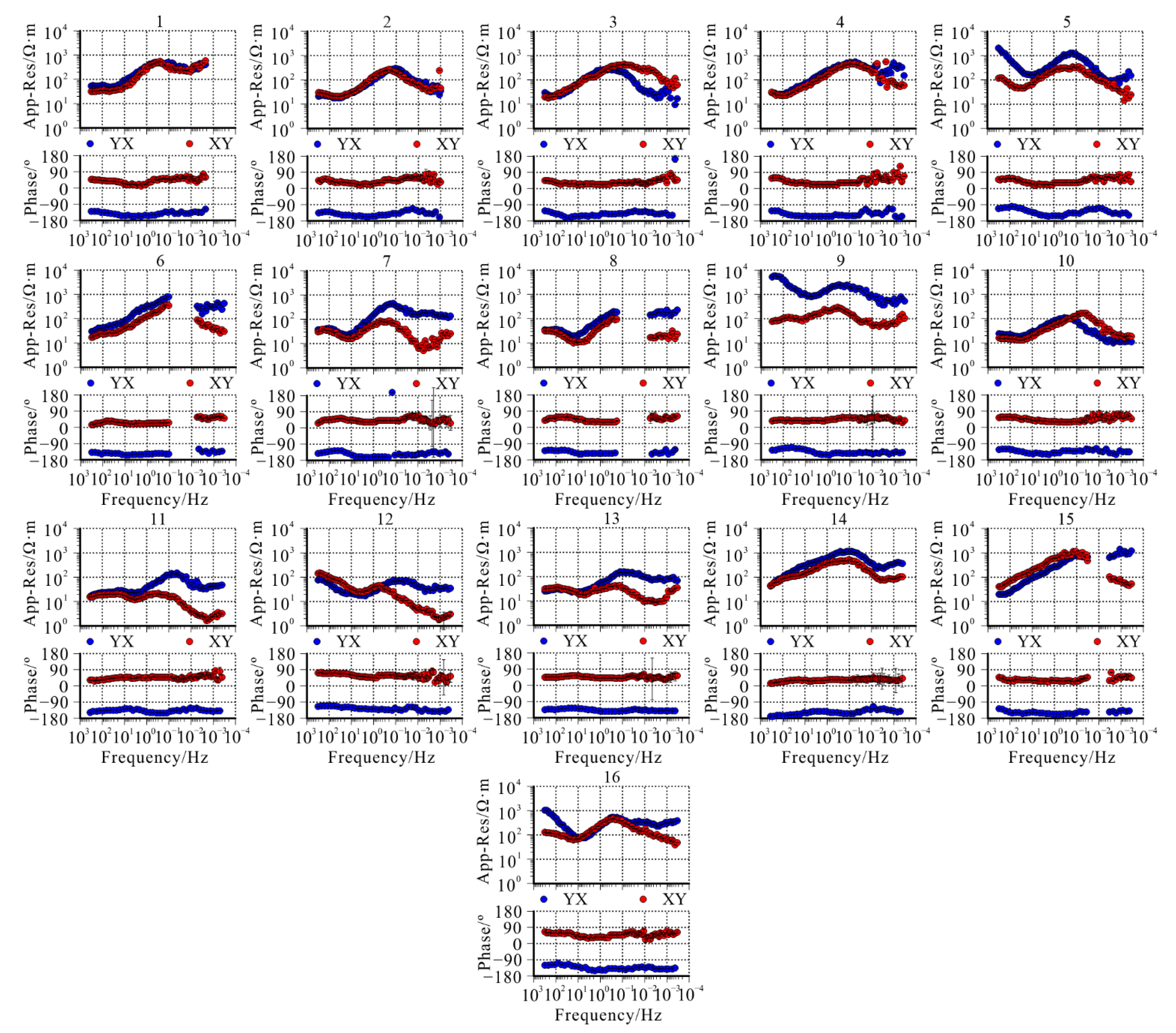
3.1. Data Acquisition

The magnetotelluric sounding profile started from the Guanting Reservoir in the east and reached the northwest of Xuanhua County in the west, with a total length of 80 km. There were 16 magnetotelluric sounding points, with an average distance of 5 km. The measuring instrument was an MTU-5A (Phoenix Company, Toronto, ON, Canada). We measured three mutually orthogonal magnetic field components (Hx, Hy, and Hz) and two mutually orthogonal electric field components (Ex and Ey). The subscripts x, y, and z indicate the north–south direction, the east–west direction, and the vertical direction, respectively. The acquisition frequency band of the instrument was 320–0.0005 Hz. To reduce the influence of random noise on data quality, the observation time was more than 18 h.

3.2. Data Processing

SSMT200 software, provided by Phoenix, was used for data processing. First, the original time series was transformed from the time domain to the frequency domain by Fourier transform. Then, robust estimation was used to obtain apparent resistivity, phase, and impedance [30]. After processing, the apparent resistivity and phase curves of all measuring points were obtained, which showed the underground electrical characteristics. Figure 3 shows the apparent resistivity and phase curves of all measuring points in the study area. Overall, the study area has low resistivity, with typical basin resistivity characteristics. In terms of the shape of the curve, the resistivity is lower in the frequency range higher than 1 Hz, which may be related to the sedimentary caprock of the basin. In the 1–0.01 Hz range, it has relatively high resistivity, showing that the crust of the study area has high resistance, which is related to the crystalline basement of the basin. It has a low resistivity in the frequency range below 0.01 Hz, showing that the deep part of the basin has lower resistivity.

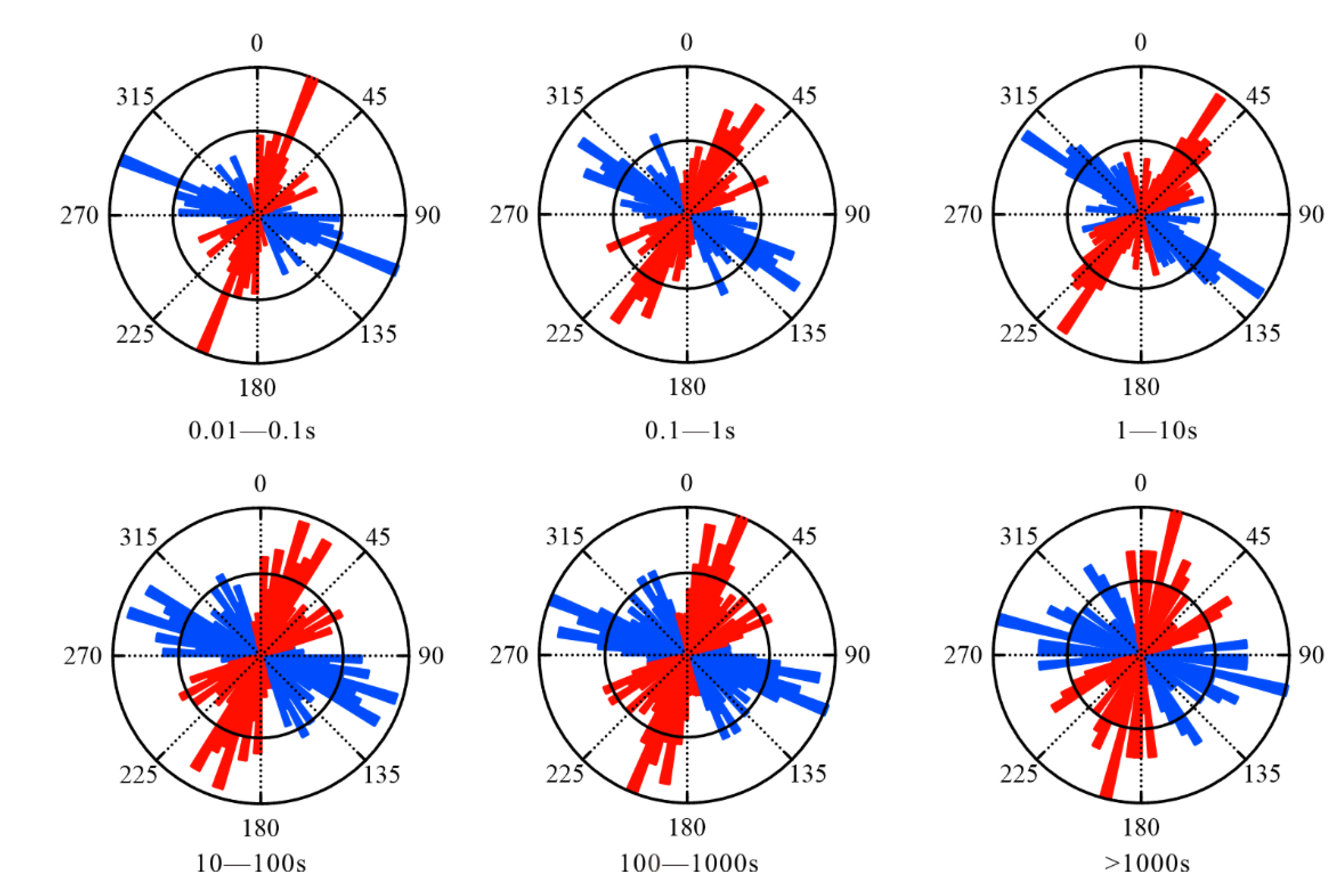
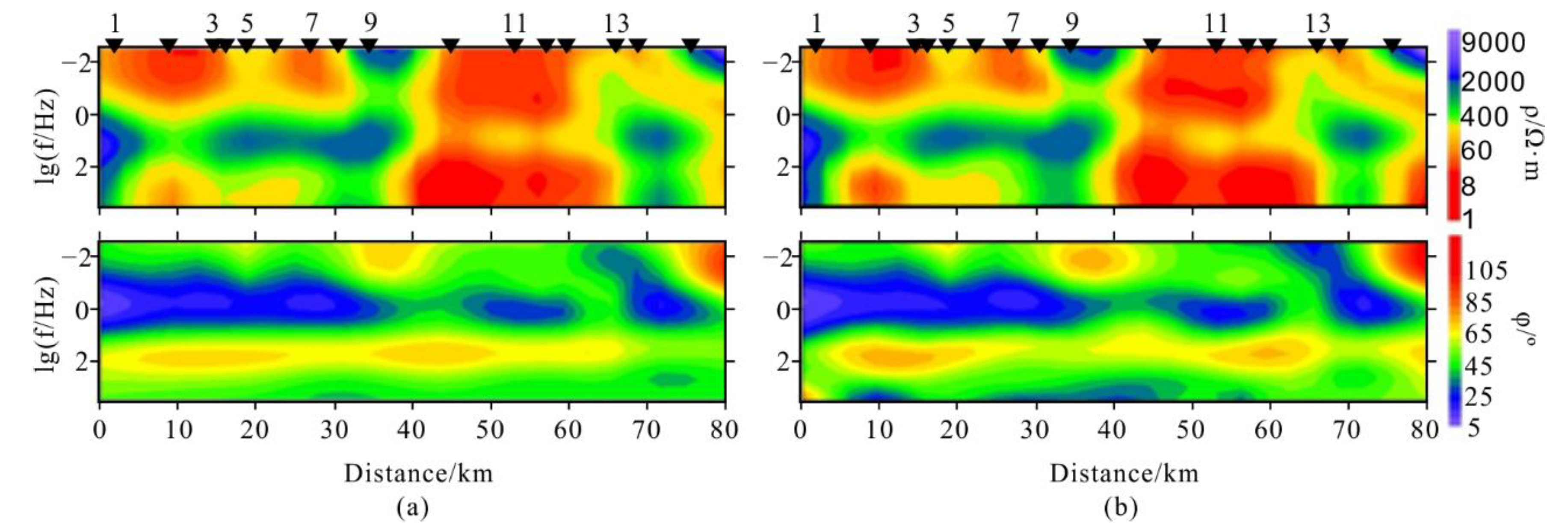
3.3. Dimensionality and Strike Direction Analysis
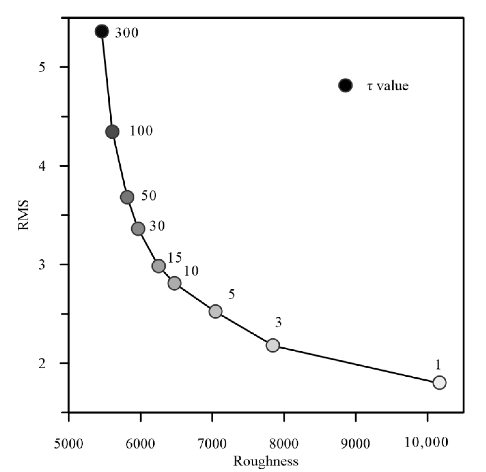
Dimensionality analysis provides an important basis for determining the inversion method (1D/2D/3D). The two-dimensional inversion must ensure that the study area has an obvious two-dimensional structure. The skewness is an important parameter reflecting the dimension of the electrical structure of the underground medium. The phase tensor is not affected by electric field distortion [31] and has a unique advantage in judging the dimensionality of the area. In this study, the phase tensor decomposition was used to analyze the regional dimensionality. Figure 4 shows the skewness of the study area. At present, it is generally accepted that when the skewness is less than 0.3, the underground structure can be approximated as a two-dimensional structure; when the skewness is greater than 0.3, a three-dimensional nature of the underground structure is more likely. The calculation results showed that the overall skewness degree is <0.3; only the local skewness degree is >0.3. As a result, we found that the underground structure of the study area has obvious two-dimensional features. This provided the basis of the 2D inversion work in this study.
Before the 2D inversion of the magnetotelluric data, it was necessary to determine the electrical strike direction of the study area. We used phase tensor decomposition [31] for electrical strike analysis. Figure 5 shows the electrical strike azimuth rose diagram of all measuring points in different periods. The study area has a consistent electrical strike in different period ranges, and the average angle is about 40°. As most of the faults in the study area are in the north–east direction, the direction of electrical strike was determined to be 40°.

4. MT Inversion

The study area as a whole has a two-dimensional characteristic. The polarization mode perpendicular to the strike of the regional structure (TM mode, defined as Transverse Magnetic mode, which means that there is no magnetic field in the propagation direction) is not susceptible to three-dimensional structures and is a preferred inversion mode [32].
After screening the power spectrum, rotating the impedance tensor [31,32], and excluding the frequency points with a large skewness degree, 2D inversion of TM data was conducted using the non-linear conjugate gradient (NLCG) method [33]. The following parameters were used: a 100 Ω·m half-space initial model and a mesh of 40 × 30 cells in the horizontal and vertical directions, respectively. Inversion mode was selected as the TM polarization mode (error floor selected as apparent resistivity = 10%, phase = 5%), and the inversion frequency was set to 320–0.0005 Hz. A horizontal smoothing control parameter (α) of one was set. The exponential factor (β), which controls the vertical smoothness, was set to zero, and a minimum block size in the horizontal and vertical directions of 500 m × 500 m was set. Inversion was performed with a variety of smoothing values (τ = 1, 3, 5, 10, 15, 30, 50, 100, and 300) to obtain an L-curve (Figure 6). The maximum number of iterations allowed for each inversion was 200. The τ = 10 model was chosen as the final model, since it represented the optimal balance between model roughness and date fitting [34]. The number of inversion iterations was 156, with an acceptable RMS (Root Mean Square) misfit of 2.8. Figure 7 shows the apparent resistivity and phase pseudo-sections of the observed data and model responses of the TM model. The measured data and the model response data fit well, which further illustrated the reliability of the two-dimensional inversion results.

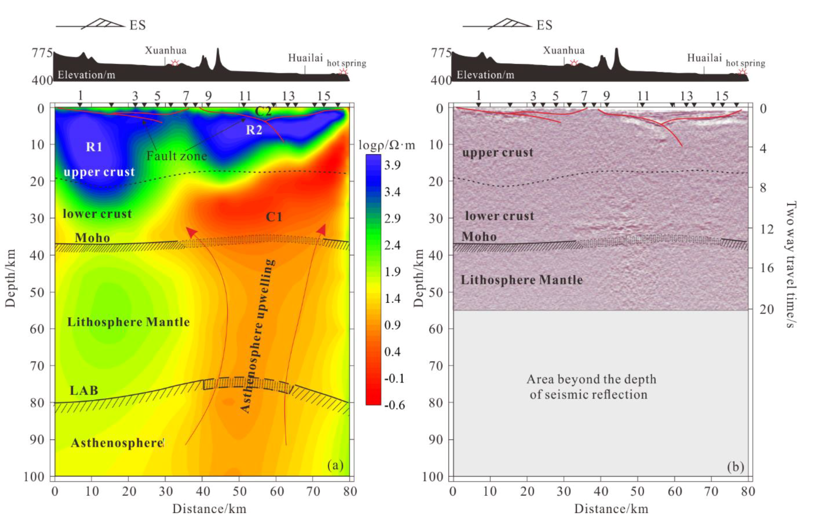
5. Deep Structurural Features and Analysis

5.1. Features of the Deep Structure

Figure 8 shows the deep structural features of the study area: Figure 8a shows the deep electrical structural features, and Figure 8b shows the deep seismic reflection characteristics [29]. Overall, the electrical structure has a strong consistency with that revealed by the reflected seismic result. It can be roughly divided into three layers in the vertical direction. The first layer, above 2 km, is a thin, low-resistance C2 body with a resistivity value of 200–300 Ω·m, showing a horizontal layered reflection in the seismic results, which gradually thickens from both sides of the basin to the middle. The second layer, between 2 and 25 km, is composed of the high-resistive anomalies R1 and R2 with resistivity values ranging from 1000 to 4000 Ω·m; as a whole, there is no obvious reflector characteristics in the seismic profile, and the thickness gradually increases along the Huailai–Xuanhua direction. The third layer, under 25 km, is mainly characterized by high-conductor C1 extending to a depth of 100 km, with a resistivity value of 3–30 Ω m; similarly, the conductor C1 appears as an irregular bright spot reflection anomaly in the seismic reflection.

5.2. Analysis of Structure Characteristics

Combining the regional geological and deep structural analysis (Figure 8) of the Huailai area revealed that in the upper crust, the shallow low-resistance C2 body shown on the electrical profile appears as a horizontal layered reflector in the seismic reflection. This corresponds to the sedimentary cover and strata of the basin, and its thickness gradually increases from the edge to the center of the basin; the average thickness is about 2 km [13]. The high-resistance R1 and R2 bodies under the Huailai Basin and Xuanhua Basin have no obvious reflection interface and appear as strong reflectors in the seismic reflection, showing characteristics of uniformity and stability; this is presumed to be the reflection of the Archean gneiss of the crystalline basement of the basin, with a thickness of about 25 km [12]. On the horizontal scale, along the Huailai–Xuanhua direction, the thickness of the upper crust tends to increase [35], which corresponds with the high resistance R1 and R2 bodies in the electrical structure.
In the lower crust, the electrical profile shows the presence of the high conductor, C1. At the same position in the reflected seismic profile, there is also a strong energy bright spot reflection anomaly, which extends downward through the Moho plane. Due to the depth limitation of the reflected seismic date, the bright spot reflection is cut off to a depth of about 55 km (Figure 8b). The result of the MT profile shows that the C1 anomaly has a deeper root, which penetrates the lithospheric mantle and connects with the asthenosphere. A seismic bright spot reflector in the lower crust is usually interpreted as magma, water, or a combination of both [36]. The MT result showed that the C1 extends to 100 km, which is obviously unsuitable for interpretation as only water. In addition, early studies indicated that there may be an upwelling of mantle-derived material in this area [3,4,12,37]. It can be inferred that the formation of the high-conductivity C1 anomaly is closely related to the magma or upwelling of deep mantle-derived material.

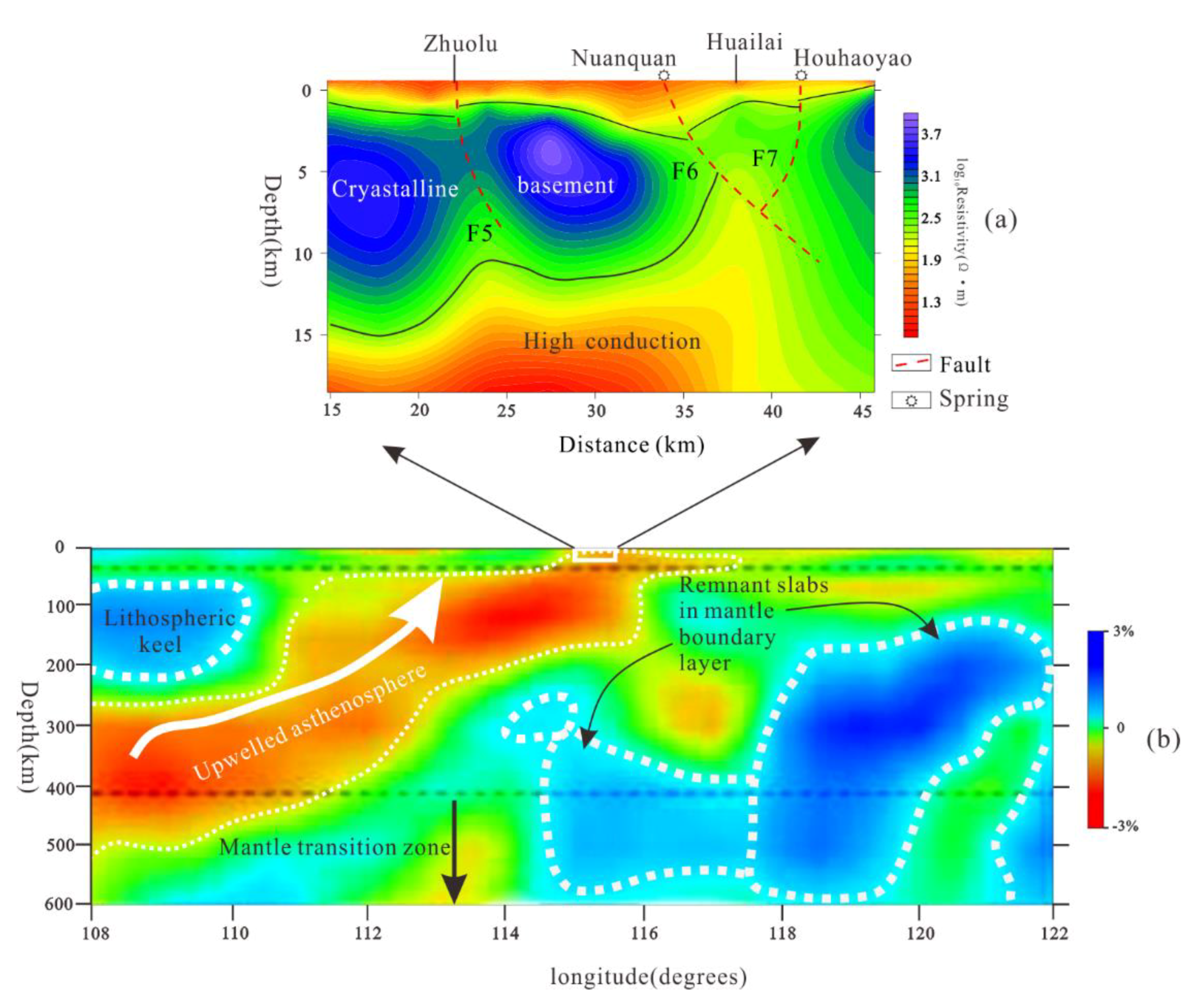
6. Analysis of Deep Geothermal Elements

A complete geothermal system has four elements: a heat source, a thermal reservoir, a thermal channel, and a cap layer [7]. The Huailai area has developed fault systems and good thermal channel conditions (Figure 1). It can be divided into three water storage layers from the bedrock and above [8], with suitable water storage and caprock conditions (Figure 2). However, the origin of the deep heat source and its relationship with the thermal reservoir fracture system are still unclear.

6.1. The Formation of the Heat Source

Heat sources can be divided into magmatic and non-magmatic types [7]. From the structure revealed by the magnetotelluric profile, there is a high-conductivity C1 structure under the basement of the Huailai Basin, which appears as a bright spot reflector in the seismic reflection. In the larger-scale seismic tomography (Figure 9b) [38], C1 is connected to a low-velocity P-wave body that extends southwest to the depth of the Ordos block below 400 km, which is interpreted as an upwelling of asthenospheric mantle [39]. Thus, it has the ability to form a heat source.
Helium isotope, as an inert gas, provides an excellent tracing effect. In geothermal systems, helium isotopes can provide clearer mantle source information. Generally, 3He isotopes exist in the mantle, 4He isotopes are mainly generated in the crust, and the helium isotopes in the atmosphere are mainly derived from the degassing of the earth. In the long evolution, the value of 3He/4He forms the three-terminal component of the atmosphere, the crust, and the mantle. The value of 3He/4He in the atmosphere is basically constant. When the gas in the mantle enters the crust and degasses, the value of 3He/4He is reduced. Therefore, the value of 3He/4He in hot spring gas mainly depends on the flux of mantle-derived helium isotope and can reflect the deep material composition of hot spring water [2]. Table 1 shows the contribution rate of the three different sources in the value of 3He/4He. The larger the value, the greater the proportion of helium isotopes from a certain source. The helium isotope mainly comes from crust sources, which is mixed with considerable mantle source helium isotope content. These mantle-derived helium isotopes were interpreted as the result of the melting and degassing of mantle-derived materials [2].
In addition, there is no significant increase in the content of radioactive elements in the hot spring water (gas). The main cations are Ca2+, Mg2+, Na+, K+; among them, K+ mainly comes from the dissolution of silicate and sulfate [1,2]. There are no increases in the content of other radioactive elements (e.g., Th and U) or their decay elements (e.g., Pb and Rn), which shows that the crust is not radioactive, further proving that the heat source is not radioactive.
Therefore, the formation of abundant geothermal resources requires the contribution of deeper heat sources. The existence of deep mantle-derived materials can reasonably explain the rich geothermal resources in the Huailai area. Mantle material upwelling is generally characterized by high electrical conductivity. The high-conductor C1 we found in the Huailai area supports this inference. Mantle-derived materials upwelled to the Huailai area and accumulated under the crystalline basement. Along with melting, a magma heat source formed, which provided the conditions for the formation of abundant geothermal resources in the Huailai area.

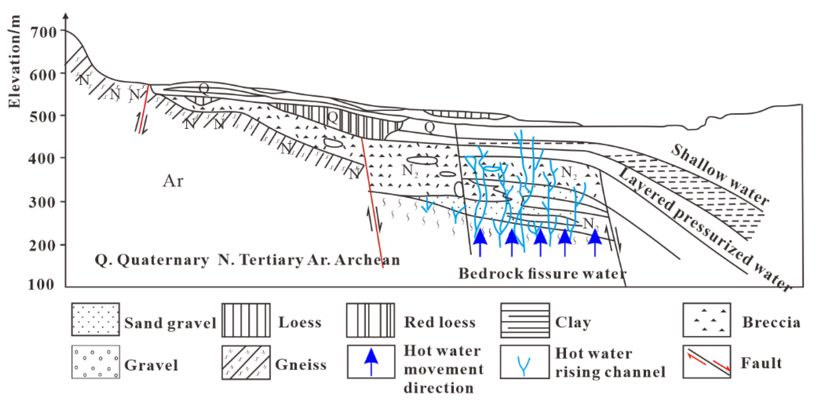
6.2. The Transfer of Heat Energy

The electrical structure obtained by MT shows that the heat carried by the C1 heat source needs to be transferred to the surface through the crystalline basement R2. There are three faults, F5, F6, and F7, in the basement, all of which terminate near the high conductor C1, and the faults F6 and F7 connect to the Nuanquan hot spring and the Houhaoyao hot spring (Figure 9a) [40]. The basement faults connect groundwater with the deep heat source. Related geochemical studies showed that the chemical type of the hot spring water in the Huailai area was mostly SO4–Na type, with high geothermal water temperature, large circulation depth (Table 2), and high Li+ and F concentrations [2]; this was the result of the interaction between geothermal water and gneiss or granite [41]. Gneiss is the main lithology of the crystalline basement in this area, indicating that the groundwater interacts with the crystalline basement during the circulation process. The results of helium isotope tracing showed that crust-sourced helium has a dominant position, and the depth of water circulation exceeds the thickness of sedimentary strata (~2000 m) (Table 2). This shows that the crystalline basement plays a role in heat conduction and storage in the geothermal system. The three aquifers divided by the bedrock and its overlying strata have good water storage performance, and the cover layer ensures good reservoir conditions (Figure 2).

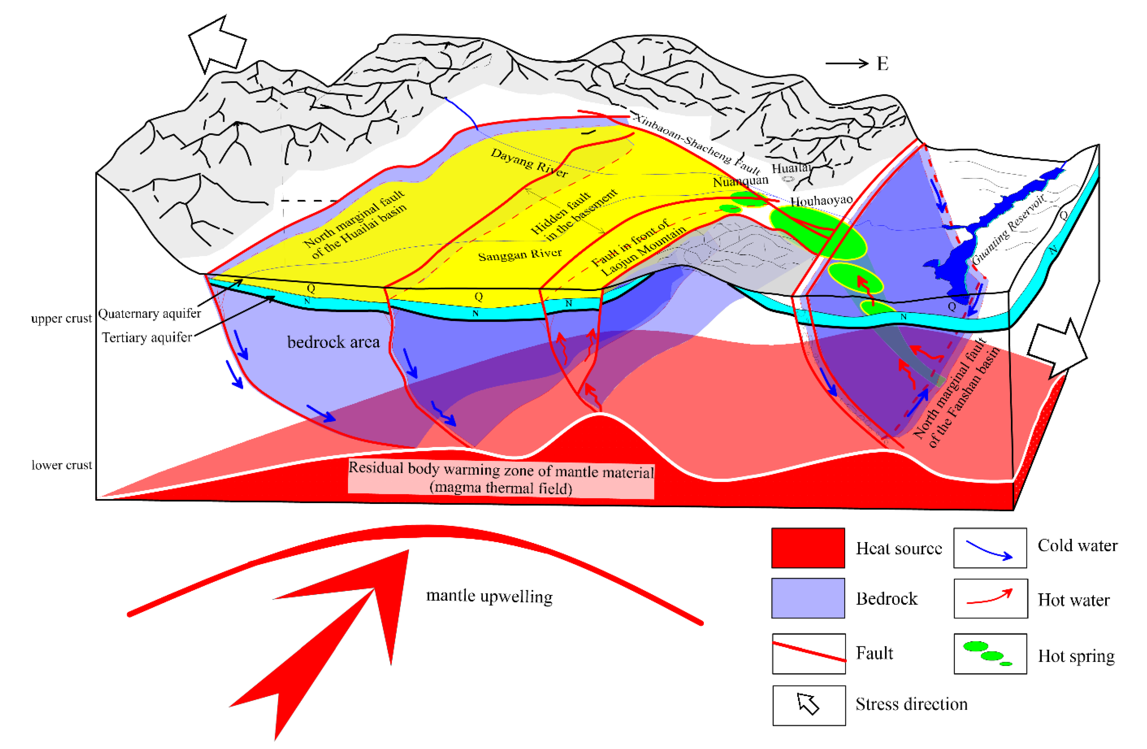
7. Geothermal Genesis Model

Using the structural information obtained from the MT, seismic reflection, and large-scale seismic tomography, combined with the analysis of geology, water chemistry, and helium isotope tracing, we established a complete geothermal system model in the Huailai area.
First, under the crystalline basement of the Huailai Basin, there is a high-conductivity and reflection anomaly, indicating the relatively active structural features below the basement. Combining the results of helium isotope tracing and the lack of an obvious heat source in the Huailai area, it is thought that the high conductivity and reflection anomaly under the basement is caused by the upwelling of mantle-derived material. The upwelling mantle-derived material carries large amounts of heat and is enriched under the basement. Due to melting, a magmatic heat source formed, which is the main reason for the abundant geothermal resources in the Huailai area. In contrast, the Xuanhua Basin, adjacent to the Huailai Basin, is relatively poor in geothermal resources due to its distance from the heat source.
Secondly, the crystalline basement connects the deep heat source and the groundwater circulation system through the faults (F5, F6, and F7 in Figure 9a) in the basement. Then, the heat is transferred to the surface through the groundwater cycle. The crystalline basement plays an important role in heat storage; it ensures that heat will not be lost quickly and can then be continuously transferred to the surface.
Third, under the influence of NW extensional tectonic stress, the regional faults (F1, F2, F3, and F4 in Figure 1) create the permeability of the upper crust, which ensures the recharge and circulation of groundwater that allows for the continuous transference of heat energy to the surface.
Finally, the Tertiary and Quaternary clay and silt layers overlying the bedrock provide the geothermal water with a good aquifer and caprock (Figure 2).
The geothermal system in the Huailai area has the typical characteristics of a magma-type geothermal system. From bottom to top, the geothermal structure of the Huailai area can be divided into a magma-type heat source, a crystalline basement heat storage layer, and caprock. The F1–F7 faults constitute the circulation network of the geothermal system, which connects the deep heat source to the groundwater. A conceptual model of the geothermal system in the Huailai area was established, as shown in Figure 10.

8. Conclusions

The high conductivity and bright spot reflection anomaly of the lower crust in the Huailai area is caused by the upwelling and enrichment of mantle-derived materials. The melting of upwelling mantle-derived materials forms a magma-type heat source, which is the main heat source in the Huailai area.
The crystalline basement is characterized by high electrical resistance, which plays an important role in heat conduction and storage in the geothermal system.
The geothermal system in the Huailai area is divided from bottom to top into a magma-type heat source, a crystalline basement, and caprock, which constitute the basic geothermal structure. They are connected by the F1–F7 faults and form a complete geothermal system in the Huailai area.

Author Contributions

Conceptualization, H.J. and L.W.; writing—original draft preparation, M.F.; writing—review and editing, H.J.; methodology, L.W.; validation, H.J., L.W., and M.F.; formal analysis, M.F.; visualization, M.F. and L.W.; supervision, L.L.; project administration, H.J. All authors have read and agreed to the published version of the manuscript.

Funding

This research was funded by the National Key R&D Program of China (grant No. 2017YFC0601305) and the National Natural Science Foundation of China (grant No. 41504076), SinoProbe-02.

Institutional Review Board Statement

Not applicable.

Informed Consent Statement

Not applicable.

Data Availability Statement

The data are not publicly available due to regulations of the related program.

Acknowledgments

The authors thank the anonymous reviewers for carefully reading the manuscript and providing many helpful comments to improve the quality of this work.

Conflicts of Interest

The authors declare no conflict of interest.

References

  1. Wang, Y. A Study of Characteristics and Models for Spring Discharge and Temperature of Low-to-Moderate Thermal Springs in Beijing and Northern Hebei. Ph.D. Thesis, China University of Geosciences, Beijing, China, 2010. [Google Scholar]
  2. Zhang, W. Fluid Geochemistry of Springs in the Basin and Range Province on the Northwest of Beijing. Master’s Thesis, Institute of Earthquake Science, China Earthquake Administration, Beijing, China, 2013. [Google Scholar]
  3. Che, Y.; Wang, J.; Jin, Y.; Liu, W.; Song, G. Character of thernal fluids in upper crust and relationship with seismicity in YANQING-HUAILAI basin. Seismol. Geol. 2001, 23, 49–54. [Google Scholar]
  4. Song, X.; Zhang, C.; Li, H.; Zhang, X. Analysis of the relationship between the water mercury anomaly in Huailai 4 well and earthquakes and its mechanism. Seismol. Geomagn. Obs. Res. 2006, 1, 17–21. [Google Scholar]
  5. Zhang, Z.; Sun, B.; Sun, D. The features and origins of geothermal water in Baxia region of Zhangjiakou. J. Hebei College 1993, 5, 459–465. [Google Scholar]
  6. Hu, B. Study on the Geogas Field and Exploration Method of the Deep Cycle Infiltration-Type Concealed Hot Springs. Ph.D. Thesis, Chengdu University of Technology, Chengdu, China, 2017. [Google Scholar]
  7. Patro, P. Magnetotelluric studies for hydrocarbon and geothermal resources: Examples from the Asian region. Surv. Geophys. 2017, 38, 1005–1041. [Google Scholar] [CrossRef]
  8. Hao, W. Geological characteristics and cause of the houhaoyao geothermal resources in Huailai. Ground Water. 2015, 5, 29–32. [Google Scholar] [CrossRef]
  9. Muffler, L. Tectonic and hydrologic control of the nature and distribution of geothermal resources. Geo Heat Center Q. Bull. 1993, 15, 2. [Google Scholar]
  10. Wang, G.; Zhang, W.; Lin, W.; Liu, F.; Zhu, X.; Liu, Y.; Li, J. Research on formation mode and development potential of geothermal resources in Beijing-Tianjin-Hebei region. Geol. China 2017, 44, 1074–1085. [Google Scholar] [CrossRef]
  11. Zhang, W.; Du, J.; Zhou, X.; Wang, F. Mantle volatiles in spring gases in the Basin and Range Province on the west of Beijing, China: Constraints from helium and carbon isotopes. J. Volcanol. Geotherm. Res. 2016, 309, 45–52. [Google Scholar] [CrossRef]
  12. Zhang, X.; Wang, C.; Liu, G.; Song, J.; Luo, L.; Wu, T.; Wu, J. Fine crustal structure in Yanqing-Huailai region by deep seismic reflection profiling. Acta Geophys. Sin. 1996, 39, 356–364. [Google Scholar]
  13. Zhu, Z.; Zhang, X.; Zhang, J.; Zhang, C.; Zhao, J.; Gai, J.; Zhao, F. Study on crust-mantle tectonics and its velocity structure along the beijing-huailai-fengzhen profile. Acta Seismol. Sin. 1997, 10, 615. [Google Scholar] [CrossRef]
  14. Li, W.; Gao, R.; Keller, R.; Li, Q.; Hou, H.; Li, Y.; Zhang, S. Crustal structure of the northern margin of north China craton from Huailai to Sonid Youqi profile. Chin. J. Geophys. 2014, 57, 472–483. (In Chinese) [Google Scholar] [CrossRef]
  15. Spichak, V.; Manzella, A. Electromagnetic sounding of geothermal zones. J. Appl. Geophys. 2009, 68, 459–478. [Google Scholar] [CrossRef]
  16. Zhang, L.; Hao, T.; Xiao, Q.; Wang, J.; Zhou, L.; Qi, M.; Cui, X.; Cai, N. Magnetotelluric investigation of the geothermal anomaly in Hailin, Mudanjiang, northeastern China. J. Appl. Geophys. 2015, 118, 47–65. [Google Scholar] [CrossRef] [Green Version]
  17. Bai, D.; Meju, M.; Liao, Z. Magnetotelluric images of deep crustal structure of the Rehai geothermal field near Tengchong, southern China. Geophys. J. Int. 2001, 147, 677–687. [Google Scholar] [CrossRef] [Green Version]
  18. Piña-Varas, P.; Ledo, J.; Queralt, P.; Marcuello, A.; Bellmunt, F.; Hidalgo, R.; Messeiller, M. 3-D magnetotelluric exploration of Tenerife geothermal system (Canary Islands, Spain). Surv. Geophys. 2014, 35, 1045–1064. [Google Scholar] [CrossRef]
  19. Cherkose, B.A.; Mizunaga, H. Resistivity imaging of Aluto-Langano geothermal field using 3-D magnetotelluric inversion. J. Afr. Earth Sci. 2018, 139, 307–318. [Google Scholar] [CrossRef]
  20. Delhaye, R.; Rath, V.; Jones, A.G.; Muller, M.R.; Reay, D. Quantitative geothermal interpretation of electrical resistivity models of the Rathlin Basin, Northern Ireland. Geothermics 2019, 77, 175–187. [Google Scholar] [CrossRef]
  21. Daud, Y.; Nuqramadha, W.A.; Fahmi, F.; Sesesega, R.S.; Pratama, S.A.; Munandar, A. Resistivity characterization of the Arjuno-Welirang volcanic geothermal system (Indonesia) through 3-D Magnetotelluric inverse modeling. J. Asian Earth Sci. 2019, 174, 352–363. [Google Scholar] [CrossRef]
  22. Maithya, J.; Fujimitsu, Y. Analysis and interpretation of magnetotelluric data in characterization of geothermal resource in eburru geothermal field, kenya. Geothermics 2019, 81, 12–31. [Google Scholar] [CrossRef]
  23. Wu, Z.; Yuan, B.; Sun, J.; Liu, Z. Neotectonics and seismicity of Yan-Huai Basin in Hebei Province. Seismol. Geol. 1979, 1, 46–56. [Google Scholar]
  24. Xu, X. New Changing of Crustal Tectonic and Earthquakes in Capital Circle. Beijing Sci. Press 2002, 160–163. (In Chinese) [Google Scholar]
  25. Ran, Y.; Wang, Y.; Fang, Z. Tentative analysis of slip patterns and segment types of active faults. Seismol. Geol. 1992, 14, 227–236. [Google Scholar]
  26. Wang, P.; Tian, Y.; Li, C.; Chen, Y. Seismicity and active faults in Huailai Basin. Acta Seismol. Sin. 1997, 19, 551–554. (In Chinese) [Google Scholar]
  27. Yu, G.; Xu, X.; Zhu, A.; Ma, W.; Diao, G.; Zhang, S.; Zhang, X.; Liu, B.; Sun, Z. Study on relationship between deep and shallow structures along north boundary fault of Yanqing-Fanshan basin. Acta Seismol. Sin. 2004, 26, 68–76. [Google Scholar] [CrossRef]
  28. Sheng, Y.; Zhang, Z.; Zhou, X.; Du, J.; Zhou, Y.; Zhang, G.; Zhang, R.; Liu, Y.; Sun, Y.; Ding, Z. Geochemical characteristics of soil gas in the Xinbaoan-Shacheng fault. Earthquake 2015, 35, 90–98. [Google Scholar]
  29. Zhang, S.; Gao, R.; Li, H.; Hou, H.; Wu, H.; Li, Q.; Yang, T.; Li, C.; Li, W.; Zhang, J.; et al. Crustal structures revealed from a deep seismic reflection profile across the Solonker suture zone of the Central Asian Orogenic Belt, northern China: An integrated interpretation. Tectonophysics 2014, 612, 26–39. [Google Scholar] [CrossRef]
  30. Egbert, G.D.; Booker, J.R. Robust estimation of geomagnetic transfer functions. Geophys. J. Int. 1986, 87, 173–194. [Google Scholar] [CrossRef] [Green Version]
  31. Caldwell, T.G.; Bibby, H.M.; Brown, C. The magnetotelluric phase tensor. Geophys. J. Int. 2004, 158, 457–469. [Google Scholar] [CrossRef] [Green Version]
  32. Cai, J.; Chen, X. Refined techniques for data processing and two-dimensional inversion in magnetotelluric Ⅱ: Which data polarization mode should be used in 2D inversion. Chin. J. Geophys. 2010, 53, 2703–2714. (In Chinese) [Google Scholar] [CrossRef]
  33. Rodi, W.; Mackie, R.L. Nonlinear conjugate gradients algorithm for 2-D magnetotelluric inversion. Geophysics 2001, 66, 174–187. [Google Scholar] [CrossRef]
  34. Patro, P.K.; Harinarayana, T. Deep geoelectric structure of the Sikkim Himalayas (NE India) using magnetotelluric studies. Phys. Earth Planet. Inter. 2009, 173, 171–176. [Google Scholar] [CrossRef]
  35. Gao, W.; Ma, J. Seismo-Geological Background and Earthquake Hazardr in Beijing Area (Atlas); Seismological Press: Beijing, China, 1993. (In Chinese) [Google Scholar]
  36. Lu, Z.; Gao, R.; Wang, H.; Li, W.; Li, H. Bright spots in deep seismic reflection profiles. Prog. Geophys. 2014, 29, 2518–2525. [Google Scholar] [CrossRef]
  37. Liu, M.; Liu, M.; Shen, X.; Zhao, L.; He, W.; Hu, X. A study of relation between mangnetic structure in deep crust of Yanqing, Huailai areas and seismicity. North China Earthq. Sci. 1994, 12, 53–58. [Google Scholar]
  38. Santosh, M.; Zhao, D.; Kusky, T. Mantle dynamics of the paleoproterozoic north china craton: A perspective based on seismic tomography. J. Geodyn. 2010, 49, 53. [Google Scholar] [CrossRef]
  39. Tian, Y.; Zhao, D.; Sun, R.; Teng, J. Seismic imaging of the crust and upper mantle beneath the north china craton. Phys. Earth Planet. Inter. 2009, 172, 169–182. [Google Scholar] [CrossRef]
  40. Liu, W.; Li, T.; Han, J.; Liu, G.; Chen, Y.; Han, F.; Han, S. The deep seismogenic environment beneath the Huailai-Zhuolu area and the mechanism of the Zhuolu M4. 3 earthquake on 6 September 2014. Chin. J. Geophys. 2017, 60, 2693–2706. (In Chinese) [Google Scholar] [CrossRef]
  41. Stober, I.; Bucher, K. Deep groundwater in the crystalline basement of the black forest region. Appl. Geochem. 1999, 14, 237–254. [Google Scholar] [CrossRef]
Figure 1. The geology and magnetotelluric sounding method (MT) site layout of the study area (the seismic line is modified from [29]).
Applsci 11 02086 g001
Figure 2. Geological profile of the aquifer (modified from [8]).
Applsci 11 02086 g002
Figure 3. Typical measured point apparent resistivity (App-Res) phase curve (Off-diagonal impedance component YX and XY).
Applsci 11 02086 g003
Figure 4. Two-dimensional deviation degree pseudo-section diagram (phase tensor decomposition).
Applsci 11 02086 g004
Figure 5. Rose diagrams of structural strike analysis in different periods (the red shows the calculated direction of the electrical strike; the blue shows the ambiguity of 90°).
Applsci 11 02086 g005
Figure 6. Model roughness and RMS curve (L-curve) obtained by inversion of different regularization factors (the different gray shades of each point represent different τ values, and the color becomes darker as the τ value becomes larger).
Applsci 11 02086 g006
Figure 7. Pseudo-section diagram of measured data (a) and response data (b) of Tranverse Magnetic (TM) apparent resistivity and impedance phase.
Applsci 11 02086 g007
Figure 8. Deep geoelectric structure (a) and seismic reflection imaging (b) in the Huailai area (seismic reflection imaging modified according to [29]).
Applsci 11 02086 g008
Figure 9. Underground structure of the Huailai area. (a) MT inversion results (modified from [40]); (b) P-wave seismic tomography (modified from [38]).
Applsci 11 02086 g009
Figure 10. Conceptual model of geothermal formation in the Huailai area.
Applsci 11 02086 g010
Table 1. The contribution rate of three different source in the value of 3He/4He.
Hot SpringAtmosphere SourceCrust SourceMantle Source
Nuanquan0.175.624.3
Houhaoyao0.192.47.5
The contribution rate units are %. The data are from [2]; the cyclic depth data are from [1].
Table 2. The groundwater circulation depth and the thermal storage temperature.
Hot SpringReference [1]Reference [2]
Circulation Depth (m)Thermal Storage Temperature (°C)Circulation Depth (m)Thermal Storage Temperature (°C)
Nuanquan1910.5>66
Houhaoyao4025.31154600106
The “—” indicates that the data are not calculated. Note: the temperature calculation uses the geochemical geothermometer, and the premise is that the reaction between the water–rock system reaches a balance. The Nuanquan hot spring has not reached a balance, and the calculated result is lower than the actual temperature.
Publisher’s Note: MDPI stays neutral with regard to jurisdictional claims in published maps and institutional affiliations.

