Adequacy of Near Real-Time Satellite Precipitation Products in Driving Flood Discharge Simulation in the Fuji River Basin, Japan
Abstract
1. Introduction
2. Study Area and Data
2.1. Study Area
2.2. Data
2.2.1. Precipitation Data
2.2.2. Other Model Input Data
3. Methodology
3.1. Bias Correction Methods
3.1.1. Simple Multiplicative Bias Correction
3.1.2. Ratio Bias Correction
3.2. Evaluation Criteria
3.3. Hydrological Model
4. Results and Discussion
4.1. Evaluation of SPPs
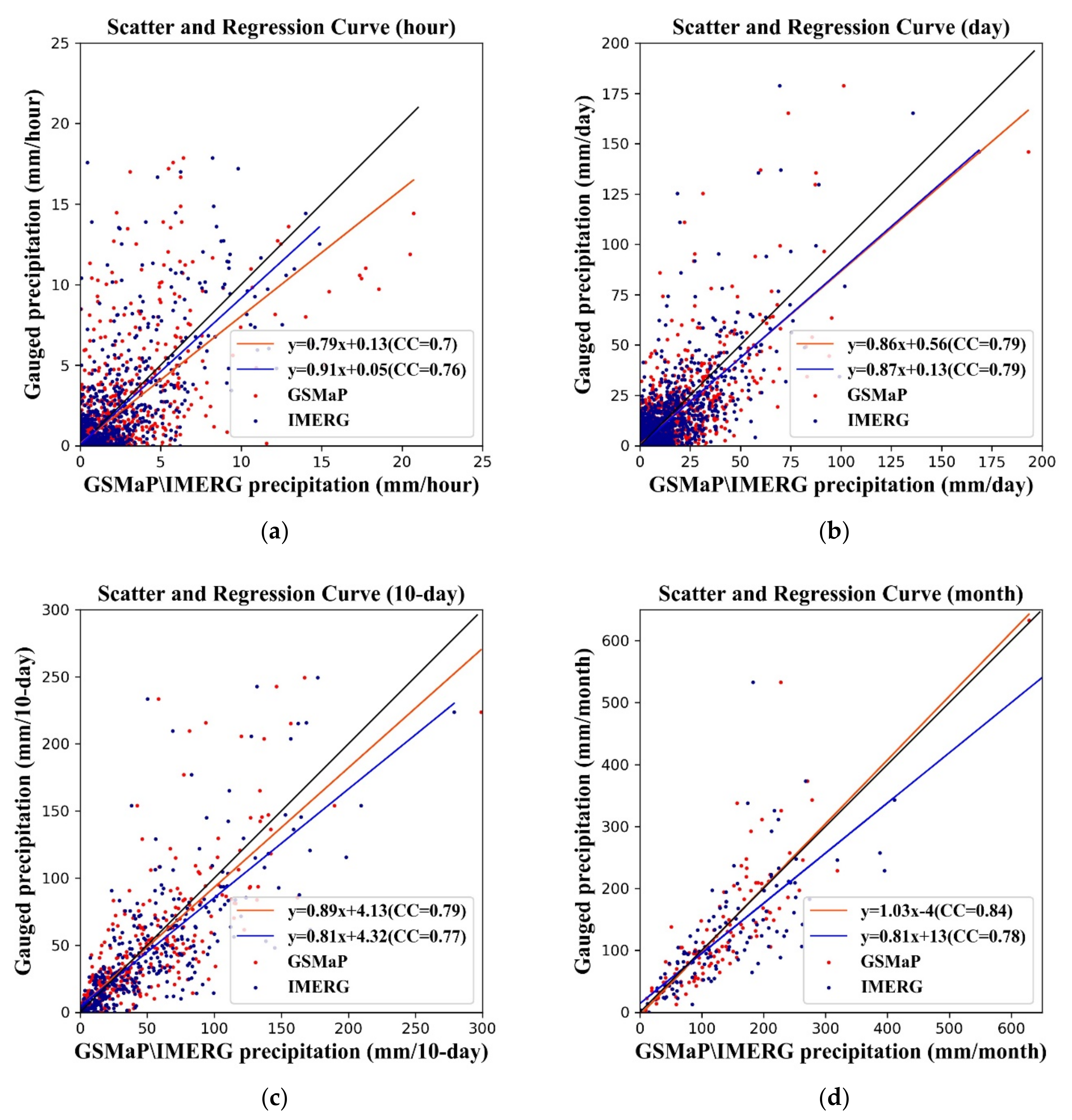
4.1.1. General Evaluation
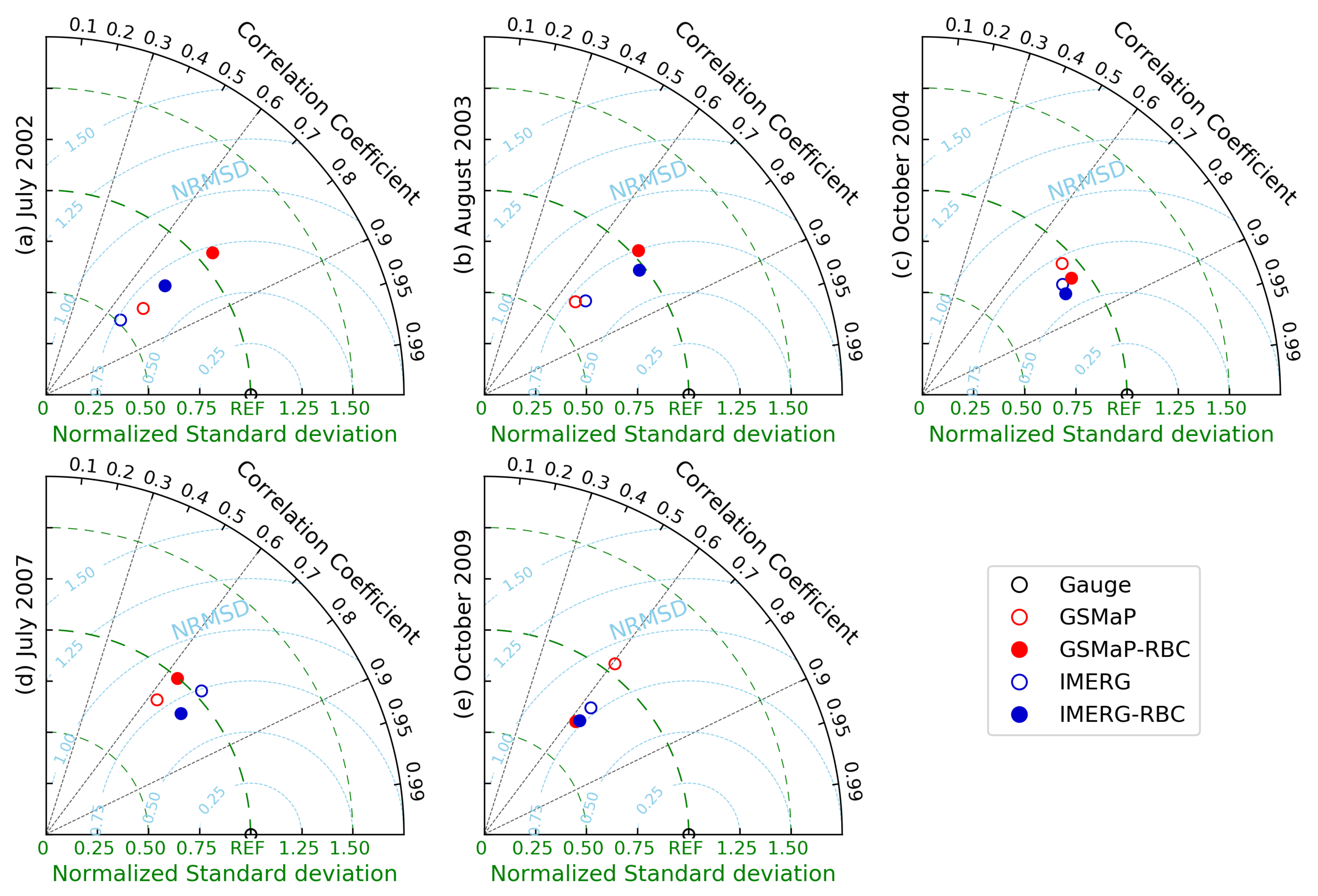
4.1.2. Case Evaluation
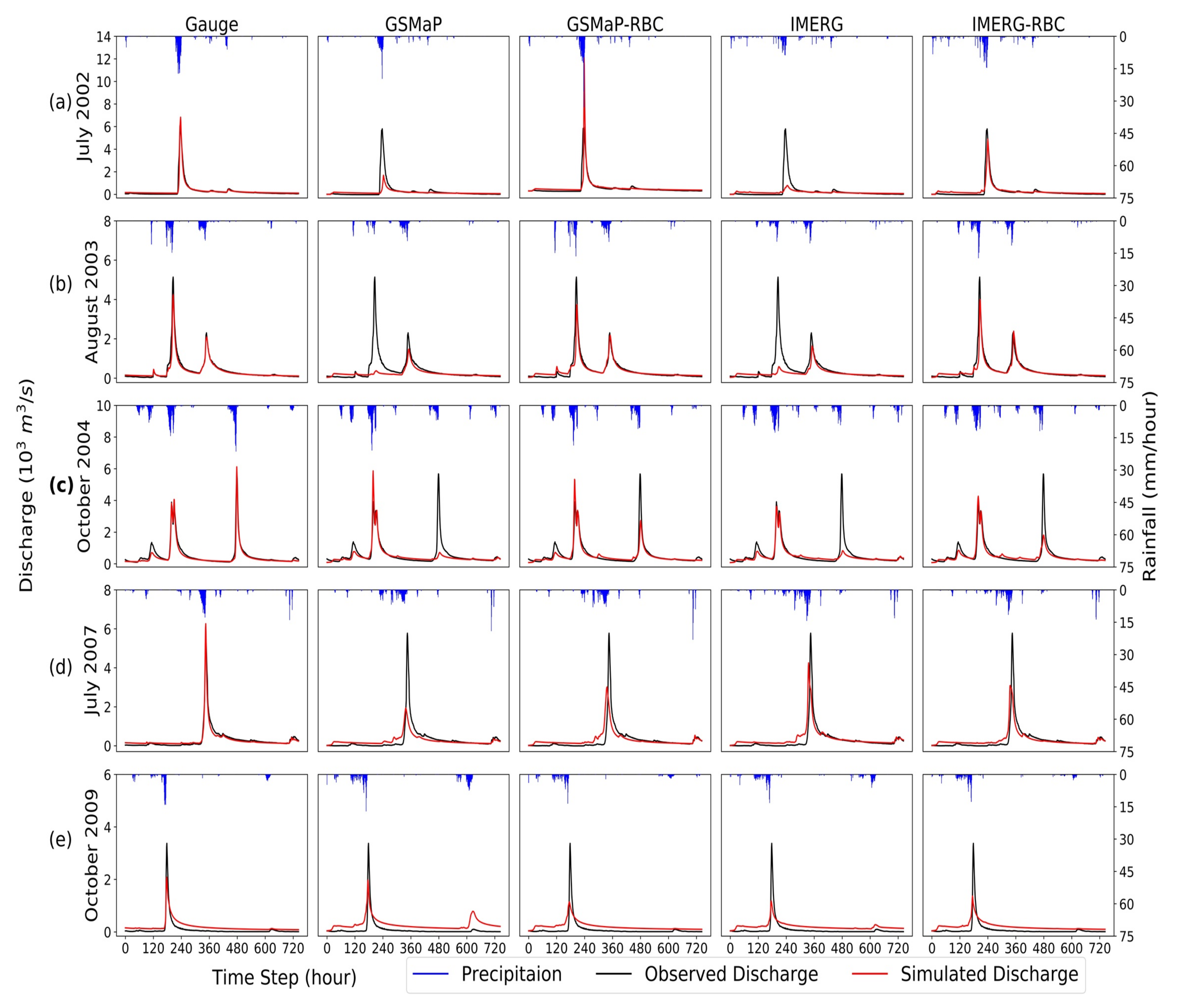
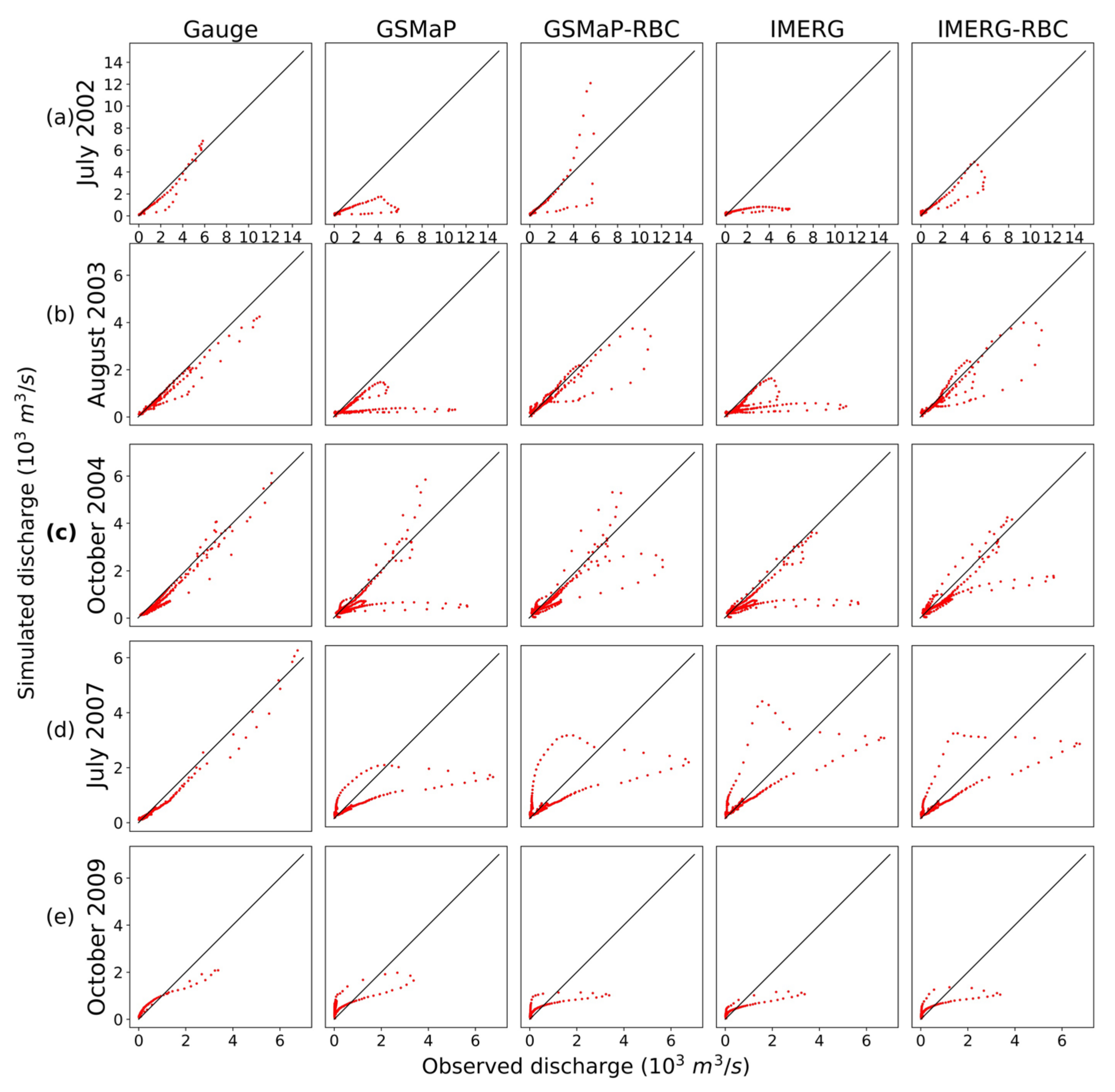
4.2. Flood Discharge Simulation
5. Conclusions
Author Contributions
Funding
Institutional Review Board Statement
Informed Consent Statement
Data Availability Statement
Acknowledgments
Conflicts of Interest
References
- Zhang, K.; Xue, X.; Hong, Y.; Gourley, J.J.; Lu, N.; Wan, Z.; Hong, Z.; Wooten, R. iCRESTRIGRS: A coupled modeling system for cascading flood–landslide disaster forecasting. Hydrol. Earth Syst. Sci. 2016, 20, 5035–5048. [Google Scholar] [CrossRef]
- Alfieri, L.; Pappenberger, F.; Wetterhall, F.; Haiden, T.; Richardson, D.; Salamon, P. Evaluation of ensemble streamflow predictions in Europe. J. Hydrol. 2014, 517, 913–922. [Google Scholar] [CrossRef]
- Gebregiorgis, A.S.; Hossain, F. Understanding the dependence of satellite rainfall uncertainty on topography and climate for hydrologic model simulation. IEEE Trans. Geosci. Remote 2013, 51, 704–718. [Google Scholar] [CrossRef]
- Marani, M. Non-power-law-scale properties of rainfall in space and time. Water Resour. Res. 2005, 41. [Google Scholar] [CrossRef]
- Renard, B.; Kavetski, D.; Kuczera, G.; Thyer, M.; Franks, S.W. Understanding predictive uncertainty in hydrologic modeling: The challenge of identifying input and structural errors. Water Resour Res. 2010, 46. [Google Scholar] [CrossRef]
- Li, D.; Christakos, G.; Ding, X.; Wu, J. Adequacy of TRMM satellite rainfall data in driving the SWAT modeling of Tiaoxi catchment (Taihu lake basin, China). J. Hydrol. 2018, 556, 1139–1152. [Google Scholar] [CrossRef]
- Xue, X.; Hong, Y.; Limaye, A.S.; Gourley, J.J.; Huffman, G.J.; Khan, S.I.; Dorji, C.; Chen, S. Statistical and hydrological evaluation of TRMM-based Multi-satellite Precipitation Analysis over the Wangchu Basin of Bhutan: Are the latest satellite precipitation products 3B42V7 ready for use in ungauged basins? J. Hydrol. 2013, 499, 91–99. [Google Scholar] [CrossRef]
- Huffman, G.J.; Bolvin, D.T.; Nelkin, E.J.; Wolff, D.B.; Adler, R.F.; Gu, G.; Hong, Y.; Bowman, K.P.; Stocker, E.F. The TRMM multisatellite precipitation analysis (TMPA): Quasi-global, multiyear, combined-sensor precipitation estimates at fine scales. J. Hydrometeorol. 2007, 8, 38–55. [Google Scholar] [CrossRef]
- Sorooshian, S.; Hsu, K.; Gao, X.; Gupta, H.V.; Imam, B.; Braithwaite, D. Evaluation of PERSIANN system satellite-based estimates of tropical rainfall. B. Am. Meteorol. Soc. 2000, 81, 2035–2046. [Google Scholar] [CrossRef]
- Joyce, R.J.; Janowiak, J.E.; Arkin, P.A.; Xie, P. CMORPH: A method that produces global precipitation estimates from passive microwave and infrared data at high spatial and temporal resolution. J. Hydrometeorol. 2004, 5, 487–503. [Google Scholar] [CrossRef]
- Ushio, T.; Sasashige, K.; Kubota, T.; Shige, S.; Okamoto, K.; Aonashi, K.; Inoue, T.; Takahashi, N.; Iguchi, T.; Kachi, M.; et al. A kalman filter approach to the global satellite mapping of precipitation (GSMaP) from combined passive microwave and infrared radiometric data. J. Meteorol. Soc. Jpn. 2009, 87, 137–151. [Google Scholar] [CrossRef]
- Kubota, T.; Shige, S.; Hashizume, H.; Aonashi, K.; Takahashi, N.; Seto, S.; Hirose, M.; Takayabu, Y.N.; Ushio, T.; Nakagawa, K.; et al. Global precipitation map using satellite-borne microwave radiometers by the GSMaP project: Production and validation. IEEE Trans. Geosci. Remote 2007, 45, 2259–2275. [Google Scholar] [CrossRef]
- IMERG: Integrated Multi-Satellite Retrievals for GPM|NASA Global Precipitation Measurement Mission. Available online: https://gpm.nasa.gov/data/imerg (accessed on 10 December 2020).
- Tekeli, A.E.; Fouli, H. Evaluation of TRMM satellite-based precipitation indexes for flood forecasting over Riyadh City, Saudi Arabia. J. Hydrol. 2016, 541, 471–479. [Google Scholar] [CrossRef]
- Koriche, S.A.; Rientjes, T.H.M. Application of satellite products and hydrological modelling for flood early warning. Phys. Chem. Earth Parts A/B/C 2016, 93, 12–23. [Google Scholar] [CrossRef]
- Wu, H.; Adler, R.F.; Tian, Y.; Huffman, G.J.; Li, H.; Wang, J. Real-time global flood estimation using satellite-based precipitation and a coupled land surface and routing model. Water Resour. Res. 2014, 50, 2693–2717. [Google Scholar] [CrossRef]
- Lai, C.; Zhong, R.; Wang, Z.; Wu, X.; Chen, X.; Wang, P.; Lian, Y. Monitoring hydrological drought using long-term satellite-based precipitation data. Sci. Total Environ. 2019, 649, 1198–1208. [Google Scholar] [CrossRef]
- Yong, B.; Chen, B.; Gourley, J.J.; Ren, L.; Hong, Y.; Chen, X.; Wang, W.; Chen, S.; Gong, L. Intercomparison of the Version-6 and Version-7 TMPA precipitation products over high and low latitudes basins with independent gauge networks: Is the newer version better in both real-time and post-real-time analysis for water resources and hydrologic extremes? J. Hydrol. 2014, 508, 77–87. [Google Scholar] [CrossRef]
- Chen, S.; Hong, Y.; Gourley, J.J.; Huffman, G.J.; Tian, Y.; Cao, Q.; Yong, B.; Kirstetter, P.; Hu, J.; Hardy, J.; et al. Evaluation of the successive V6 and V7 TRMM multisatellite precipitation analysis over the Continental United States. Water Resour. Res. 2013, 49, 8174–8186. [Google Scholar] [CrossRef]
- Lo Conti, F.; Hsu, K.; Noto, L.V.; Sorooshian, S. Evaluation and comparison of satellite precipitation estimates with reference to a local area in the Mediterranean Sea. Atmos. Res. 2014, 138, 189–204. [Google Scholar] [CrossRef]
- Belabid, N.; Zhao, F.; Brocca, L.; Huang, Y.; Tan, Y. Near-real-time flood forecasting based on satellite precipitation products. Remote Sens. 2019, 11, 252. [Google Scholar] [CrossRef]
- Shi, J.; Yuan, F.; Shi, C.; Zhao, C.; Zhang, L.; Ren, L.; Zhu, Y.; Jiang, S.; Liu, Y. Statistical evaluation of the latest GPM-era IMERG and GSMaP satellite precipitation products in the Yellow river source region. Water 2020, 12, 1006. [Google Scholar] [CrossRef]
- Yuan, F.; Zhang, L.; Soe, K.; Ren, L.; Zhao, C.; Zhu, Y.; Jiang, S.; Liu, Y. Applications of TRMM- and GPM-era multiple-satellite precipitation products for flood simulations at sub-daily scales in a sparsely gauged watershed in myanmar. Remote Sens. 2019, 11, 140. [Google Scholar] [CrossRef]
- Anjum, M.N.; Ding, Y.; Shangguan, D.; Ijaz, M.W.; Zhang, S.; Ushio, T. Evaluation of high-resolution satellite-based real-time and post-real-time precipitation estimates during 2010 extreme flood event in Swat river basin, Hindukush region. Adv. Meteorol. 2016, 2016, 2604980. [Google Scholar] [CrossRef]
- Ren, P.; Li, J.; Feng, P.; Guo, Y.; Ma, Q. Evaluation of multiple satellite precipitation products and their use in hydrological modelling over the Luanhe river basin, China. Water 2018, 10, 677. [Google Scholar] [CrossRef]
- Behrangi, A.; Khakbaz, B.; Jaw, T.C.; Aghakouchak, A.; Hsu, K.; Sorooshian, S. Hydrologic evaluation of satellite precipitation products over a mid-size basin. J. Hydrol. 2011, 397, 225–237. [Google Scholar] [CrossRef]
- Shah, R.D.; Mishra, V. Development of an experimental near-real-time drought monitor for India. J. Hydrometeorol. 2015, 16, 327–345. [Google Scholar] [CrossRef]
- Borga, M.; Tonelli, F.; Moore, R.J.; Andrieu, H. Long-term assessment of bias adjustment in radar rainfall estimation. Water Resour. Res. 2002, 38, 1–8. [Google Scholar] [CrossRef]
- Xie, P.; Xiong, A. A conceptual model for constructing high-resolution gauge-satellite merged precipitation analyses. J. Geophys. Res. Space Phys. 2011, 116. [Google Scholar] [CrossRef]
- Ringard, J.; Seyler, F.; Linguet, L. A Quantile mapping bias correction method based on hydroclimatic classification of the Guiana Shield. Sensors 2017, 17, 1413. [Google Scholar] [CrossRef]
- Tian, Y.; Peters-Lidard, C.D.; Eylander, J.B. Real-time bias reduction for satellite-based precipitation estimates. J. Hydrometeorol. 2010, 11, 1275–1285. [Google Scholar] [CrossRef]
- Bhatti, H.; Rientjes, T.; Haile, A.; Habib, E.; Verhoef, W. Evaluation of bias correction method for satellite-based rainfall data. Sensors 2016, 16, 884. [Google Scholar] [CrossRef] [PubMed]
- Mastrantonas, N.; Bhattacharya, B.; Shibuo, Y.; Rasmy, M.; Espinoza-Dávalos, G.; Solomatine, D. Evaluating the benefits of merging near-real-time satellite precipitation products: A case study in the Kinu basin region, Japan. J. Hydrometeorol. 2019, 20, 1213–1233. [Google Scholar] [CrossRef]
- Kumar, A.; Ramsankaran, R.; Brocca, L.; Munoz-Arriola, F. A machine learning approach for improving near-real-time satellite-based rainfall estimates by integrating soil moisture. Remote Sens 2019, 11, 2221. [Google Scholar] [CrossRef]
- Bharti, V.; Singh, C. Evaluation of error in TRMM 3B42V7 precipitation estimates over the Himalayan region. J. Geophys. Res. Space Phys. 2015, 120, 12458–12473. [Google Scholar] [CrossRef]
- Wanders, N.; Pan, M.; Wood, E.F. Correction of real-time satellite precipitation with multi-sensor satellite observations of land surface variables. Remote Sens. Environ. 2015, 160, 206–221. [Google Scholar] [CrossRef]
- Awaka, J.; Le, M.; Chandrasekar, V.; Yoshida, N.; Higashiuwatoko, T.; Kubota, T.; Iguchi, T. Rain Type Classification Algorithm Module for GPM Dual-Frequency Precipitation Radar. J. Atmos Ocean Tech. 2016, 33, 1887–1898. [Google Scholar] [CrossRef]
- Shrestha, S.; Kazama, F. An export coefficient modeling approach to estimate organic matter and nutrient loadings from point and non point sources into the Fuji river, Japan. Proc. Symp. Glob. Environ. 2006, 14, 21–26. [Google Scholar] [CrossRef]
- JAXA Global Rainfall Watch. Available online: https://sharaku.eorc.jaxa.jp/GSMaP/ (accessed on 10 December 2020).
- NASA Goddard Earth Sciences (GES) Data and Information Services Center (DISC). Available online: https://disc.gsfc.nasa.gov/ (accessed on 10 December 2020).
- LP DAAC-SRTMGL3. Available online: https://lpdaac.usgs.gov/products/srtmgl3v003/ (accessed on 10 December 2020).
- LP DAAC-MCD12Q1. Available online: https://lpdaac.usgs.gov/products/mcd12q1v006/ (accessed on 10 December 2020).
- FAO Digital Soil Map of the World (DSMW). Available online: http://www.fao.org/land-water/land/land-governance/land-resources-planning-toolbox/category/details/en/c/1026564/ (accessed on 10 December 2020).
- NOAA Climate Data Record (CDR) of Normalized Difference Vegetation Index (NDVI), Version 4 (Version Superseded). Available online: https://www.ncei.noaa.gov/access/metadata/landing-page/bin/iso?id=gov.noaa.ncdc:C00813 (accessed on 10 December 2020).
- Harris, I.; Osborn, T.J.; Jones, P.; Lister, D. Version 4 of the CRU TS monthly high-resolution gridded multivariate climate dataset. Sci. Data 2020, 7. [Google Scholar] [CrossRef]
- Goly, A.; Teegavarapu, R.S.V. Optimization and variants of quantile-based methods for bias corrections of statistically downscaled precipitation data. J. Hydrol. Eng. 2020, 25, 4020027. [Google Scholar] [CrossRef]
- Gentile, M.; Courbin, F.; Meylan, G. Interpolating point spread function anisotropy. Astron. Astrophys. 2013, 549, A1. [Google Scholar] [CrossRef]
- Azpurua, M.A.; Ramos, K.D. A comparison of spatial interpolation methods for estimation of average electromagnetic field magnitude. Prog. Electromagn. Res. M 2010, 14, 135–145. [Google Scholar] [CrossRef]
- Takeuchi, K.; Ao, T.; Ishidaira, H. Introduction of block-wise use of TOPMODEL and Muskingum-Cunge method for the hydroenvironmental simulation of a large ungauged basin. Hydrol. Sci. J. 1999, 44, 633–646. [Google Scholar] [CrossRef]
- Takeuchi, K.; Hapuarachchi, P.; Zhou, M.; Ishidaira, H.; Magome, J. A BTOP model to extend TOPMODEL for distributed hydrological simulation of large basins. Hydrol. Process. 2008, 22, 3236–3251. [Google Scholar] [CrossRef]
- Ao, T.; Ishidaira, H.; Takeuchi, K. Study of distributed runoff simulation model based on block type TOPMODEL and muskingum-cunge method. Proc. Hydr. Eng. 1999, 43, 7–12. [Google Scholar] [CrossRef]
- Ao, T.; Ishidaira, H.; Takeuchi, K.; Kiem, A.S.; Yoshitari, J.; Fukami, K.; Magome, J. Relating BTOPMC model parameters to physical features of MOPEX basins. J. Hydrol. 2006, 320, 84–102. [Google Scholar] [CrossRef]
- Beven, K.J.; Kirkby, M.J. A physically based, variable contributing area model of basin hydrology. Hydrol. Sci. Bull. 1979, 1, 43–69. [Google Scholar] [CrossRef]
- Magome, J.; Gusyev, M.A.; Hasegawa, A.; Takeuchi, K. River discharge simulation of a distributed hydrological model on global scale for the hazard quantification. In Proceedings of the 21st International Congress on Modelling and Simulation (MODSIM2015), Broadbeach, QLD, Australia, 29 December 2015; pp. 1593–1599. [Google Scholar]
- Gusyev, M.; Gädeke, A.; Cullmann, J.; Magome, J.; Sugiura, A.; Sawano, H.; Takeuchi, K. Connecting global- and local-scale flood risk assessment: A case study of the Rhine River basin flood hazard. J. Flood Risk Manag. 2016, 9, 343–354. [Google Scholar] [CrossRef]
- Zhang, H.; Ao, T.; Gusyev, M.; Ishidaira, H.; Magome, J.; Takeuchi, K. Distributed source pollutant transport module based on BTOPMC: A case study of the Laixi River basin in the Sichuan province of southwest China. Proc. Int. Assoc. Hydrol. Sci. 2018, 379, 323–333. [Google Scholar] [CrossRef]
- Liu, L.; Zhou, L.; Li, X.; Chen, T.; Ao, T. Screening and optimizing the sensitive parameters of BTOPMC model based on UQ-PyL software: Case study of a flood event in the Fuji river basin, Japan. J. Hydrol. Eng. 2020, 25. [Google Scholar] [CrossRef]
- Zhou, M.C.; Ishidaira, H.; Hapuarachchi, H.P.; Magome, J.; Kiem, A.S.; Takeuchi, K. Estimating potential evapotranspiration using Shuttleworth–Wallace model and NOAA-AVHRR NDVI data to feed a distributed hydrological model over the Mekong River basin. J. Hydrol. 2006, 327, 151–173. [Google Scholar] [CrossRef]
- Taylor, K.E. Summarizing multiple aspects of model performance in a single diagram. J. Geophys. Res. Atmos. 2001, 106, 7183–7192. [Google Scholar] [CrossRef]
- Bastola, S.; Murphy, C.; Sweeney, J. The role of hydrological modelling uncertainties in climate change impact assessments of Irish river catchments. Adv. Water Resour. 2011, 34, 562–576. [Google Scholar] [CrossRef]
- Tong, K.; Su, F.; Yang, D.; Hao, Z. Evaluation of satellite precipitation retrievals and their potential utilities in hydrologic modeling over the Tibetan Plateau. J. Hydrol. 2014, 519, 423–437. [Google Scholar] [CrossRef]


| Metrics | Time Scale | GSMaP-NRT | IMERG Early | ||||||||
|---|---|---|---|---|---|---|---|---|---|---|---|
| Original | SMBC | RBC | Original | SMBC | RBC | ||||||
| Month Factor | 10-Day Factor | Month Factor | 10-Day Factor | Month Factor | 10-Day Factor | Month Factor | 10-Day Factor | ||||
| CC | Hourly | 0.76 | 0.75 | 0.77 | 0.75 | 0.77 | 0.80 | 0.80 | 0.70 | 0.77 | 0.80 |
| Daily | 0.79 | 0.78 | 0.90 | 0.78 | 0.90 | 0.79 | 0.76 | 0.90 | 0.76 | 0.90 | |
| 10 days | 0.79 | 0.77 | 1.00 | 0.77 | 1.00 | 0.77 | 0.71 | 1.00 | 0.72 | 1.00 | |
| Monthly | 0.84 | 0.82 | 0.99 | 0.82 | 0.99 | 0.78 | 0.73 | 0.99 | 0.73 | 0.99 | |
| BIAS | Hourly | −0.03 | −0.08 | 0.03 | −0.08 | 0.03 | −0.02 | 0.17 | 0.10 | −0.11 | 0.04 |
| Daily | 0.04 | −0.05 | −0.01 | −0.04 | 0.00 | 0.46 | 0.04 | 0.00 | 0.04 | 0.00 | |
| 10 days | 0.45 | −0.49 | −0.08 | −0.42 | 0.00 | 4.58 | 0.35 | 0.00 | 0.42 | 0.00 | |
| Monthly | 1.37 | −1.47 | −0.25 | −1.28 | 0.00 | 13.94 | 1.07 | −0.01 | 1.29 | 0.00 | |
| MAE | Hourly | 0.39 | 0.38 | 0.42 | 0.38 | 0.42 | 0.37 | 0.46 | 0.46 | 0.37 | 0.40 |
| Daily | 2.87 | 2.92 | 2.13 | 2.93 | 2.15 | 3.05 | 3.00 | 2.19 | 2.98 | 2.22 | |
| 10 days | 17.51 | 18.01 | 0.08 | 18.08 | 0.00 | 19.48 | 19.06 | 0.00 | 19.00 | 0.00 | |
| Monthly | 36.35 | 34.34 | 6.28 | 34.36 | 6.02 | 44.19 | 42.41 | 5.74 | 42.00 | 5.97 | |
| RMSE | Hourly | 1.23 | 1.21 | 1.23 | 1.22 | 1.23 | 1.08 | 1.31 | 1.51 | 1.16 | 1.14 |
| Daily | 7.51 | 7.65 | 5.29 | 7.67 | 5.33 | 7.44 | 7.78 | 5.19 | 7.76 | 5.23 | |
| 10 days | 27.83 | 28.76 | 0.40 | 28.87 | 0.00 | 30.22 | 32.35 | 0.04 | 32.19 | 0.00 | |
| Monthly | 52.64 | 55.16 | 11.75 | 55.34 | 11.53 | 64.90 | 68.99 | 10.05 | 68.47 | 10.23 | |
| Cases | Metrics | Gauge | GSMaP | GSMaP-RBC | IMERG | IMERG-RBC |
|---|---|---|---|---|---|---|
| July 2002 | NSE | 0.94 | 0.27 | 0.45 | 0.2 | 0.81 |
| CC | 0.97 | 0.71 | 0.79 | 0.78 | 0.93 | |
| BIAS | 22.34 | −83.15 | 53.46 | −81.04 | 25.47 | |
| RMSE | 176.02 | 625.87 | 544.55 | 655.3 | 321.45 | |
| August 2003 | NSE | 0.94 | 0.14 | 0.83 | 0.21 | 0.82 |
| CC | 0.99 | 0.49 | 0.93 | 0.56 | 0.92 | |
| BIAS | −31.03 | −152.59 | −6.32 | −139.42 | −13.06 | |
| RMSE | 151.66 | 576.5 | 259.14 | 554.55 | 260.8 | |
| October 2004 | NSE | 0.95 | 0.46 | 0.76 | 0.53 | 0.71 |
| Calibration | CC | 0.98 | 0.7 | 0.88 | 0.75 | 0.85 |
| BIAS | −72.42 | −88.45 | −43.32 | −98.52 | −57.61 | |
| RMSE | 165.23 | 555.06 | 367.5 | 518.98 | 409.01 | |
| July 2007 | NSE | 0.96 | 0.48 | 0.48 | 0.61 | 0.66 |
| CC | 0.98 | 0.78 | 0.7 | 0.79 | 0.83 | |
| BIAS | −5.98 | −27.22 | 17 | 70.23 | 12.72 | |
| RMSE | 121.71 | 464.15 | 462.39 | 402.04 | 372.09 | |
| October 2009 | NSE | 0.74 | 0.25 | 0.37 | 0.41 | 0.41 |
| CC | 0.95 | 0.77 | 0.75 | 0.87 | 0.78 | |
| BIAS | 100.04 | 190.29 | 115.58 | 114.84 | 113.49 | |
| RMSE | 164.73 | 281.66 | 257.63 | 248.66 | 248.72 |
Publisher’s Note: MDPI stays neutral with regard to jurisdictional claims in published maps and institutional affiliations. |
© 2021 by the authors. Licensee MDPI, Basel, Switzerland. This article is an open access article distributed under the terms and conditions of the Creative Commons Attribution (CC BY) license (http://creativecommons.org/licenses/by/4.0/).
Share and Cite
Zhou, L.; Rasmy, M.; Takeuchi, K.; Koike, T.; Selvarajah, H.; Ao, T. Adequacy of Near Real-Time Satellite Precipitation Products in Driving Flood Discharge Simulation in the Fuji River Basin, Japan. Appl. Sci. 2021, 11, 1087. https://doi.org/10.3390/app11031087
Zhou L, Rasmy M, Takeuchi K, Koike T, Selvarajah H, Ao T. Adequacy of Near Real-Time Satellite Precipitation Products in Driving Flood Discharge Simulation in the Fuji River Basin, Japan. Applied Sciences. 2021; 11(3):1087. https://doi.org/10.3390/app11031087
Chicago/Turabian StyleZhou, Li, Mohamed Rasmy, Kuniyoshi Takeuchi, Toshio Koike, Hemakanth Selvarajah, and Tianqi Ao. 2021. "Adequacy of Near Real-Time Satellite Precipitation Products in Driving Flood Discharge Simulation in the Fuji River Basin, Japan" Applied Sciences 11, no. 3: 1087. https://doi.org/10.3390/app11031087
APA StyleZhou, L., Rasmy, M., Takeuchi, K., Koike, T., Selvarajah, H., & Ao, T. (2021). Adequacy of Near Real-Time Satellite Precipitation Products in Driving Flood Discharge Simulation in the Fuji River Basin, Japan. Applied Sciences, 11(3), 1087. https://doi.org/10.3390/app11031087


