Article

Intersection-Based Routing with Fuzzy Multi-Factor Decision for VANETs

School of Computer Science and Engineering, Kyungpook National University, Daegu 41566, Korea
*
Author to whom correspondence should be addressed.
Appl. Sci. 2021, 11(16), 7304; https://doi.org/10.3390/app11167304
Submission received: 30 June 2021 / Revised: 31 July 2021 / Accepted: 7 August 2021 / Published: 9 August 2021
(This article belongs to the Topic Intelligent Transportation Systems)

Abstract

:
Due to the limitations of the urban environment, the data transferred between vehicles can only change direction at the intersections. Therefore, the routing decision at an intersection will largely affect the overall routing decision. In this article, we propose an Intersection-Based Routing with Fuzzy Multi-Factor Decision (IRFMF), which utilizes several factors to decide the next road segment. In the scheme, each intersection introduces three factors including the direction, the number of lanes, and the traffic. After the fuzzification and defuzzification of these factors, the candidate segment with the highest evaluation will be selected. The simulation shows a significant improvement of VANETs performance on packet delivery ratio and end-to-end delay.

1. Introduction

The Vehicular Ad hoc Network (VANET) is created by applying the principles of the Mobile Ad Hoc Networks (NANETs) to the vehicle, which is an important part of the Intelligent Transportation System (ITS) framework [1,2,3].
VANET can be regarded as a special practical application of wireless ad hoc networks (Ad Hoc Network). However, due to the network characteristics of VANET, such as high dynamic topology, strict delay requirements, high mobility, predictable trajectory, unlimited energy, accurate positioning, etc., its application prospects are bright and broad. The research scope spans three traditional research fields of the intelligent transportation system, computer network, and wireless communication, which makes the research on VANET attract the attention of many academic and industrial circles. VANET is now generally divided into three types of networks, namely Vehicle-to-Vehicle (V2V) ad hoc network, Vehicle-to-Infrastructure (V2I) network, and Hybrid network [4,5,6].
The main task of VANET is to transmit the collected or received data in a timely and efficient manner; however, due to the constraints of the urban environment, data transmission and forwarding between vehicles can only proceed along existing roads, and the direction changes during the data transmission and the forwarding can only appear at intersections. Therefore, vehicle routing decisions largely depend on the data forwarding decisions at the intersection; the data forwarding decision at the intersection determines the forwarding direction and the road section of the data in the next stage, which affects the data delivery rate and delay rate of the overall routing, and it also affects the quality of the routing decision. It can be said to a large extent that the decision of intersection data forwarding determines the overall routing.
The quality of a decision is affected by many factors, and if there are many factors, it is difficult to quantify them specifically in the process of evaluation and implementation. Moreover, it is difficult to give relative weight because it is difficult to judge the importance of the impact factors at the same level. The actual situation of humans evaluating things is that it is very difficult to estimate the real original value of each evaluation object, but it is easy to make a fuzzy evaluation of it with natural language, and it is easy to make a rough estimation of the relative size or the quality of its weight through a fuzzy number [7,8,9]. In this case, it is more appropriate to use the method of Triangular Fuzzy Number (TFN) for evaluation [10,11]. TFN number is a method to transfer fuzzy and uncertain linguistic variables to definite values. Using TFN in the evaluation method can solve the contradiction that the performance of the evaluated object cannot be accurately measured, but it can only be evaluated by language.
At intersections, there are many factors that affect the data forwarding decision, such as vehicle density, signal lights, destination location, road width (number of lanes), etc. Here, we select three factors including vehicle density, direction, and traffic to complete the decision making of the intersection. Firstly, a complete link is established in advance using vehicle speed between every two adjacent intersections, if it exists. Secondly, using a triangular fuzzy number, each intersection node determines the next road segment after fuzzing and defuzzifying the three factors received. Figure 1 shows the architecture of this scheme. We assume that data transmission among vehicles with IEEE 802.11p and the next-hop vehicle selection is based on the contact time. The base station (BS) provides the traffic information to the roadside unit (RSU), and the RSU determines which road segment the packet should be forward to.
The following content of the article is as follows. In Section 2, the related works are described. In Section 3, the details of the scheme proposed are elaborated. In Section 4, the simulation result is shown and analyzed, and in Section 5, the concluding remarks are provided.

2. Related Work

In this section, we briefly review some existing routing protocols in VANETs.
Generally speaking, the routing protocols proposed can be mainly divided into three different types: topology-based routing protocol [12,13,14], geographic-based routing protocol [15,16,17,18,19,20,21], and cluster-based routing protocols [22,23,24]. In this paper, we focus on the geographic-based routing protocol. Geographic routing (GS) requires that not only each vehicle knows its own location, but also the source is aware of the location of the destination. With this information, GS determiners the forwarding route to the destination without knowledge of the network topology. Thus, it is more robust and promising than the topology-based routing protocol in VANETs.
As is well-known, the more famous GS must include GPSR (Greedy Perimeter Stateless Routing) [15] and GPCR (Greedy Perimeter Coordinator Routing) [16]. In GPSR, a strategy called Greedy forwarding is used, where the next-hop is selected, which is geographically closest to the destination among all one-hop neighbors. When the strategy fails because of the local maximum problem that the current node cannot find a neighbor node closer to the destination than itself geographically, a recovery strategy called Perimeter forwarding is used, where the packet is forwarded around the perimeter of a planar graph based on the right-hand rule. The GPCR can be subdivided into intersection-based geographic routing protocol; different from GPSR, GPCR introduces the intersection (junction), and all packets are first forwarded to vehicles that are at the intersection (junction); then, the next hop is determined. However, GPCR does not completely solve the local maximum problem. When it happens, the packet will be backtracked to a junction node, and then another segment is selected based on the right-hand rule.
In GSR (Geographical source routing) [25], according to the availability of a map, a global graph with junction nodes as vertices and streets as edges is drawn, and then a Dijkstra shortest path is computed to the destination. The route cannot be guaranteed to be connected because the connectivity between two junctions is not considered. The EGSR (Efficient Geographical Source Routing) [26] is the improvement of the GSR protocol. It introduces an ant-based algorithm to discover the route with optimum network connectivity. The weight of each street segment is calculated according to its connectivity, and the route with the minimum total weight will be determined by the source vehicle.
The traffic lights play a vital role in VANETs in urban areas. Another intersection-based routing protocol, STAR (Shortest-Path-Based Traffic-Light-Aware Routing) [17], takes the traffic lights into consideration to decide how the packets should be forwarded. The packets are firstly forwarded to the red light segment, which is connected. Otherwise, the packets are forwarded to the green light segment, which is closer to the destination. GTLQR (Greedy Traffic Light and Queue Aware Routing Protocol) [18] not only considers the traffic lights but also the network congestion. The scheme selects the street with the highest connectivity, which is calculated by considering traffic lights and uneven distribution of vehicles, and the next-hop vehicle is selected by considering the queuing delay, channel quality, and relative distance. In iCAR-II (iCAR-II: Infrastructure-Based Connectivity Aware Routing) [19], a dynamic real-time network topology is constructed based on the infrastructure. The shortest path can be determined based on up-to-date connectivity information. In TAROC (traffic-aware routing protocol with cooperative coverage-oriented information collection method) [20], a cooperative information collection method was proposed. First, a hierarchical information collection scheme is established by information aggregators and information collectors. Then, the scoring mechanism is used to evaluate each road according to the collected information. Finally, a routing path is determined by the data route construction mechanism based on the scoring results.
Table 1 shows the characteristics of some routing protocols.

3. Protocol Design

In this section, we describe the routing protocol we proposed in detail. As mentioned earlier, packets can only change direction at intersections due to the limitation of the urban environment. In this article, we focus on the selection of the direction of the packet at the intersection. We exploit three factors for determining the next-hop road segment with the triangular fuzzy number. Moreover, we use a restricted greed forwarding condition to determine the next-hop vehicle on the road segment between two adjacent intersections. So, the proposed routing protocol can be divided into two parts to describe in detail: (1) speed-based restricted greedy forwarding and (2) direction decision at the intersection.

3.1. Speed-Based Limited Greedy Forwarding

In order to prevent the failure of data transmission due to link breaks during data transmission, and to make the link maintain a longer lifetime, we impose a restriction on greedy forwarding. This restriction is determined by the contact time between the current vehicle and its neighbor’s vehicle. According to the distance between the heads of the vehicles and the corresponding speed, the contact time between the vehicles is calculated to select the optimal vehicle.
The relationship between time headway and vehicle speed is shown in the following formula [27]:
D = v t + k v 2 + l 0 + l
where D is the distance between two vehicles; v is the vehicle speed; k is the braking coefficient, k = 1 / 2 g φ   ( g is gravitational acceleration, φ is adhesion coefficient); l 0 is the safety distance;   l is the length of the vehicle; t (takes 0.3 s) is the driver’s response time.
In this paper, we assumed that the minimum space headway distance threshold is D m i n = 6   m, and the maximum space headway distance threshold is   D m a x = 30 m. This means that if the space headway distance measured is greater than 30 m, the current vehicle can be considered to be in a free running state; if the space headway distance is less than 6 m, the traffic is in a severely blocked state (we assume that the length of the vehicle is 5 m).
The contact time between the current vehicle and candidate vehicles can be divided into two categories, and they can be presented as the following formulas.
The first case, when the current vehicle is in the same direction as the candidate vehicle:
v 0 > v i ,   T i = D i v 0 v i ,   i = 1 , 2 n
v 0 > v i ,   T i = R D i v 0 v i ,   i = 1 , 2 n .
The second case, when the current vehicle is in the opposite direction to the candidate vehicle:
T i = D v 0 + v i ,   i = 1 , 2 n
where   T i is the contact time between the current vehicle and the i th candidate vehicle; D i is the distance between the current vehicle and the i th candidate vehicle, R = 250 m is the signal transmission radius, v 0 is the speed of the current vehicles, and v i is the speed of the i th candidate vehicle.
The mean of the contact time of the candidate vehicles is shown as the following formula:
T ˜ = 1 n i = 1 n T i , i = 1 , 2 n .
Here, it is clear that the longer the contact time, the more hops in the final link. However, the longer the contact time, the longer the lifetime of the final link. Considering the high mobility of the vehicles and to reduce the number of hops of the link, the average contact time of the candidate vehicles is calculated, and the candidate vehicle closest to the average is selected as the next hop.
Every vehicle maintains a table of information about itself including road ID, lane ID, and speed; if the vehicle is in a link, this information table also records the link information, such as link lifetime, hop count, and the completed link. The format of the beacon message is shown in Table 2. Based on the information of the beacon message, the current vehicle can select the optimum next vehicle from the candidate vehicles. Moreover, the RSU can also know the status of links between it and its neighbors.

3.2. Road Segment Selection

At intersections, there are many factors affecting the data forwarding decision, such as vehicle density, signal lights, the direction of the target node, road width (number of lanes), etc. Here, traffic flow, direction, and the number of lanes are selected to complete intersection decision making. The three key factors are described in detail as follows.
Number of lanes: Number of lanes in the road segment;
Direction: The angle between a candidate road and the line from the current intersection to the destination;
Traffic flow: The traffic flow of each road section in different time periods.
In this paper, we choose a nine-point fuzzy scale to quantify the factors we selected. The TFN is denoted as follows:
A ˜ = l , m , u
where l and u represent the lower and upper bounds of the TFN Ã, respectively, and m represents the modal value. As mentioned earlier, the purpose of TFN is to convert linguistic variables to definite values that can be used for calculations. Herein, we transfer the linguistic variables to definite values as follows in Table 3.
In the next subsections, we will describe the detail on why and how to evaluate the selected factors.

3.2.1. Number of Lanes

An important factor for each driver to choose the road segment is the road condition of the road segment, and the number of lanes in the road segment is also one of the important indicators for the driver to evaluate the road condition. Therefore, other things being equal, a road segment with more lanes tends to have more vehicles. Moreover, traffic in a one-way lane is likely to be blocked by the traffic light. Then, the fuzzy number score for the number of lanes on each candidate road segment is shown as the following formula:
N u m = { 8 ˜ ,   > 4   lanes 6 ˜ ,     two way four lane 4 ˜ ,     bi directional single lane 2 ˜ ,     o n e w a y   l a n e   .

3.2.2. Direction

In order for the data to be forwarded to the destination faster, the shorter the road passed, the fewer the number of hops in the link, and the less time it takes. The straight line between two points is the shortest; however, the urban environment determines that the data cannot be forwarded to the destination along the straight line. Make a straight line so that it passes through the current intersection and the destination, the smaller the angle between the road segment and the straight line, the closer the next intersection is to the destination, and the shorter the road through which the data passes. Calculate the counterclockwise angle between each road and the straight line. In Figure 2, the red dotted line is the line between the current intersection S and the destination D. α1, α2, α3, and α4 are respectively the counterclockwise angles of roads r1, r2, r3, and r4 with the dotted line. The direction attribute of candidate roads r1, r2, r3, and r4 could be evaluated by the angles α1, α2, α3, and α4 separately. 360° will be divided into eight portions with seven threshold degrees generated including 45°, 90°, 135°, 180°, 225°, 270°, and 315 °. According to the angle between the direction to a candidate and the direction to the destination of messages, certain scores can be assigned to each candidate. The smaller the angle is, the higher score the candidate is assigned, and the Dir to each candidate is calculated following the formula:
D i r = { 8 ˜ ,     i f   0   a n g l e 45 °   | |   315 °   a n g l e 360 ° 6 ˜ ,     i f   45 ° < d i s t a n c e 90 °   | |   270 °   a n g l e < 315 ° 4 ˜ ,     i f   90 ° < d i s t a n c e 135 °   | |   215 °   a n g l e < 270 ° 2 ˜ ,     i f   135 ° < d   a n g l e < 215 °   .

3.2.3. Traffic Flow

RSU can obtain road information under different conditions provided by the base station, such as the traffic of the road segment on a sunny day at 10 am on a Sunday, or the traffic of the road segment on a rainy day at 5 pm on a Friday. As described in the paper [28], when the traffic flow reaches 133veh/km/lane, the road is marked as crowded. In a normal urban scenario, the speed of vehicles is limited to under 70 km/h; in this case, the vehicle density is about 20 veh/km/lane. The traffic condition is divided into four types, including sparse, normal, not crowded, and crowded. The traffic of the road segment is marked as Tra and the formula is as follows:
T r a = { 8 ˜ ,     free running status 6 ˜ ,     normal     4 ˜ ,     crowded 2 ˜ ,     s p a r s e .
After completing the quantification of the factors, the next step is to evaluate the candidate road segments. The set of candidate road segments is marked as S = { S i   |   i = 1 ,   2 n } , the set of factors is F = { F j   |   j = 1 ,   2 ,   3 } , and weights is W = { w ˜ j   |   j = 1 ,   2 ,   3 } . Thus, X = { x ˜ i j   |   i = 1 ,   2 n ; j = 1 ,   2 ,   3 } means the j th fuzzy factor score of the i th candidate road segments; w ˜ j = l w j , m w j ,   u w j stands for the lower, middle, and upper values of the fuzzy weight of the j th factor.
In probability theory and statistics, variance is used to measure the degree of deviation between a random variable and its mathematical expectation. The variance is larger when the data distribution is relatively dispersed (that is, the data fluctuates greatly around the mean), the sum of squares of the difference between each data and the mean is larger. On the contrary, the variance is smaller when the data distribution is more concentrated, the sum of squares of the difference between each data and the mean is smaller. Therefore, the greater the variance, the greater the fluctuation of the data; the smaller the variance, the smaller fluctuation of the data. The arithmetic square root of the variance is called the standard deviation. In this paper, we introduce the standard deviation to measure the difference of the factor between the candidate road segments.
In order to get the standard deviation of each factor, the mean of each factor should be calculated first. The formula for calculating the mean is as follows:
r j ˜ x = 1 n i = 1 n x i j ˜ , i = 1 ,   2 n , j = 1 ,   2 ,   3 .
Then, we can calculate the standard deviation of each as following formula:
D j ˜ = 1 n i = 1 n x i j ˜ r j ˜ x 2 , i = 1 ,   2 n , j = 1 ,   2 ,   3 .
The weight of each factor also reflects the importance of each factor in the candidate road segments. The weight of the j th factor can be calculated as following formula:
w j ˜ = D j ˜ / j = 1 3 D j ˜ ,   j   = 1 ,   2 ,   3 .
Before getting the optimal candidate road segment, the final total fuzzy performance score of each candidate road segment should be calculated. Based on the fuzzy performance score and the fuzzy relative weight of each factor obtained according to the above formulas, the total fuzzy performance score of the i th candidate road segment can be calculated as following formula:
t i ˜ = j = 1 3 x i j ˜ w j ˜ , i = 1 ,   2 n , j = 1 ,   2 ,   3 .
Then, the data will be forwarded to the road segment with the highest score:
C = { t i ˜   |   m a x t i ˜ x ,   i = 1 ,   2 n } .
The t i ˜ x is still a fuzzy number; the next step is to defuzzify to compare the candidate road segments. In general, the common available methods include the mean of maximum, α-cut method, and center-of-area (COA) [29]. Herein, we select the center of area (COA) method to determine the best non-fuzzy performance (BNP) value [30] of the candidates, and the formula is as follows:
BNP i = u r i l r i + m r i l r i / 3 + l r i .
According to the value of the BNP obtained according to the above formula, the best candidate road segment can be selected.
The above content shows the process of the routing protocol we proposed in detail, and its brief flow is as follows:
Step 1: The RSU periodically sends a link discovery beacon to determine and establish a link between it and its neighbors based on the information of the beacon message.
Step 2: When the message arrives at an intersection, the RSU selects the next-hop road segment and forwards the message to the next intersection based on the score obtained by calculating the three factors.
Moreover, the pseudocode is described in Figure 3. It shows how the next-hop road segment is selected. When a packet arrives at an intersection, the RSU determines whether there is a link so that the message can be forwarded to the next intersection; if there is not, the message would return to the last intersection and select the sub-optimal road segment.
If there is only one link and the direction is correct, the message would be forwarded along this link to the next intersection; if the direction is wrong, the message also returns. Finally, if there is more than one link, the RSU calculates the BNP of the candidate road segments; then, it selects the optimum road segment and forwards the message.

4. Simulation Settings and Performance Comparison Results

In this section, we describe the details of the simulation experiments including the simulation setting and the simulation result of IRFMF, GPCR, and GSR. Then, we evaluate and compare the performance of IRFMF, GPCR, and GSR with the same parameters. The results of the comparison in different aspects will be shown in the following figure. The figures could intuitively show the excellent performance of the protocol we proposed.

4.1. Simulation Setting

The protocol we proposed is simulated using NS2 simulator, and we use the Simulation of Urban Mobility (SUMO) engine to establish an urban environment, which covers an area of 3000 m × 4000 m, as shown in Figure 4. The area contains 28 junctions, 5 road segments with one-way lanes, 6 bidirectional road segments with 2 lanes, 23 bidirectional road segments with 4 lanes, and 10 bidirectional road segments with 6 lanes. It is assumed that each point on the road segment has an equal probability of being the initial position or destination of vehicles. Some other simulation parameters are shown in Table 4.

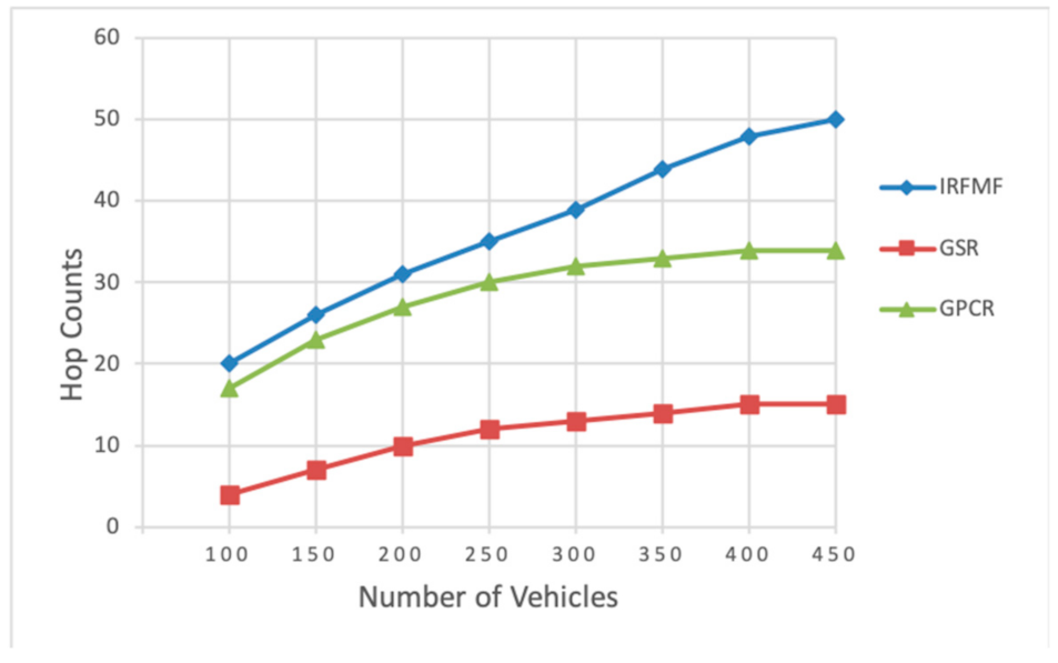
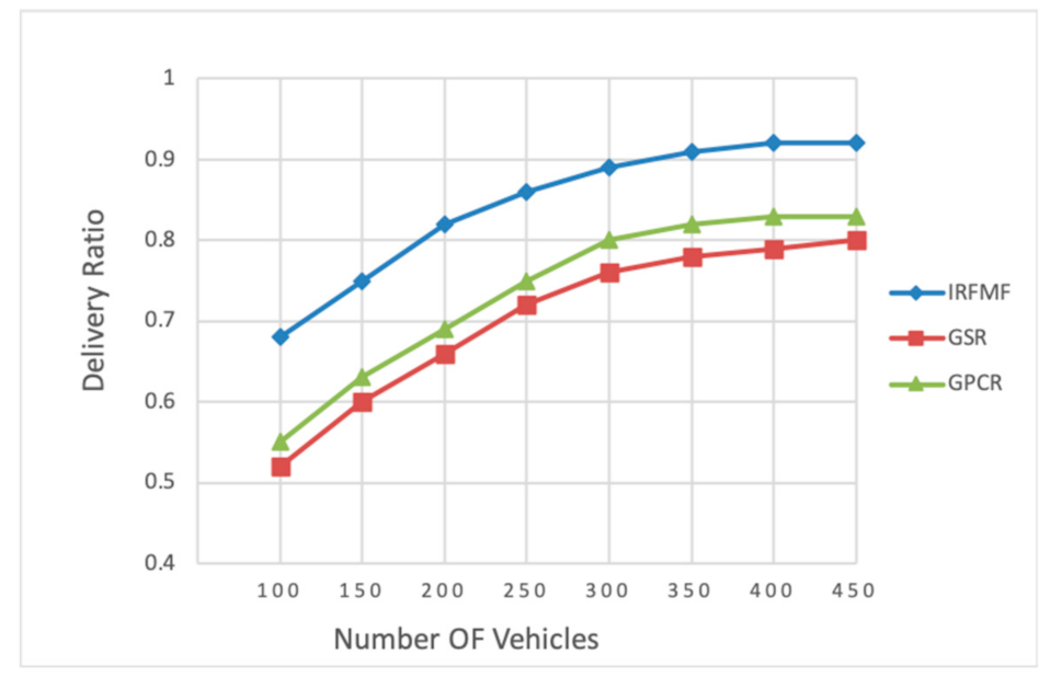
4.2. Simulation Results

Figure 5 shows how the number of the hops in the link varies with the number of the vehicles. The number of the hops increases with the number of vehicles, but IRFMF goes up even more. Similarly, as the vehicles’ density increases, so does the delivery ratio, as shown in Figure 6. Simultaneously, as the number of vehicles increases, the delay becomes lower and lower until it does not change, as shown in Figure 7.

5. Discussion

As shown in Figure 5, with the same number of vehicles, it is clear that the IRFMF has more hop counts than the GSR and the GPCR. That is because to ensure that the link has a longer lifetime, in Scheme IRFMF, the vehicle sacrifices the distance and chooses the neighbor vehicle with a longer contact time. The longer the contact time, the closer the current vehicle is to the neighbor vehicle. In the extreme case where the path is the same (the same road segments), the number of vehicles on the path is the same, and the path is crowded (that is, all vehicles are traveling at almost zero speed), the hops in IRFMF are twice as many as in other routing protocols. The lower number of hops of the GSR leads to the lower delivery ratios, while the higher delivery ratios of the IRFMF and the GPCR come at the cost of many hops. In order to deal with the local optimal solution problem, the GPCR has more hops. The IRFMF also pays a higher price for more robust and stable links than the GSR and the GPCR.
As the density of vehicles increases, so does the delivery ratio as present in Figure 6. That is because as the vehicle density increases, the links become more robust and less likely to break. This provides more opportunities for data to be transmitted to its destination. The IRFMF shows a better performance on delivery ratio than other protocols. First, because of the introduction of multiple factors, the decision on the selection of the next road segment becomes more sensible, and second, the speed-based limited greedy forwarding makes the link more robust and the link lifetime longer. Moreover, the link paths have been established when the packet arrives at the intersection; thus, before the data is forwarded at the intersection, it is known whether the link is connected and whether a lifetime can ensure that the packet can reach the next intersection, to ensure that the data can reach the next intersection smoothly. Therefore, the data delivery rate is significantly improved. Although the GSR considers the characters of the VANETs and the topology of streets when it selects the next hop for forwarding, it does not guarantee that the link between two intersections is connected. The delivery ratio of the GSR is low due to the incomplete links. Compared with the GSR, the GPCR has a higher delivery ratio because the intersections are introduced and specially designed for forwarding.
On the end-to-end delivery, as shown in Figure 7, it is clear that the IRFMF and the GPCR almost perform similarly, but there is a boundary value. When the number of vehicles exceeds this boundary value, the number of hops in the link increases and so does the delay, and the IRFMF would have a higher delay than the GPCR. This is determined by characteristics of speed-based limited greedy forwarding of the IMFMF. Unsurprisingly, the lifetime of the link also becomes longer until the density of vehicles reaches the point where vehicles cannot move. The GSR has the highest delay because when the GSR calculates the Dijkstra shortest path without considering the connectivity between the junctions, this makes it possible for the packet to be carried for a long time, which increases the delay.
In order to improve the data delivery ratio and reduce delivery delay, but also to extend the lifetime and improve the stability of the links, we sacrifice the number of hops in the link. In the future, we will pay attention to improving the speed-based limited greedy forwarding. Our goal is to minimize the number of hop counts in the link while the link lifetime is maintained long enough.

6. Conclusions

In this paper, the IRFMF proposed is an intersection-based routing protocol. The routing decision is determined at intersections by the RSU using the Triangular Fuzzy Number (TFN) combined three factors including the number of lanes, direction, and the traffic flow. The IRFMF selects the next-hop road segment based on the fuzzy score of the candidate road segment, which is calculated by comparing the real-time information of the three factors. According to the fuzzy weighting method, the packet is forwarded to the candidate road segment with the highest fuzzy score at intersections. At the same time, in order to increase the lifetime of the link between two adjacent intersections, we propose a speed-based limited greedy forwarding based on the relationship between time headway and vehicle speed. It can be said that the IRFMF makes full and effective use of the characteristics of the VANETs. The simulation results show that the performance of the IRFMF is better than other compared routing protocols in terms of data delivery ratio and end-to-end delay in the same simulation environment, although more hops are traded for more robust and stable links.

Author Contributions

Conceptualization, Z.C.; methodology, Z.C.; software, Z.C.; validation, J.K.; formal analysis, Z.C. and Z.F.; investigation, Z.C. and Z.F.; resources, J.K.; data curation, Z.C. and Z.F.; writing—original draft preparation, Z.C; writing—review and editing, Z.C. and Z.F.; visualization, Z.C.; supervision, J.K.; project administration, J.K.; funding acquisition, J.K. All authors have read and agreed to the published version of the manuscript.

Funding

This work was supported by the National Research Foundation of Korea (NRF) grant funded by the Korea government (MSIT) (No. 2019R1F1A1042721). This study was also supported by the BK21 Plus project (SW Human Resource Development Program for Supporting Smart Life) funded by the Ministry of Education, School of Computer Science and Engineering, Kyungpook National University, Korea (21A20131600005).

Conflicts of Interest

The authors declare no conflict of interest.

References

  1. Ghori, M.R.; Zamli, K.Z.; Quosthoni, N.; Hisyam, M.; Montaser, M. Vehicular ad-hoc network (VANET): Review. In Proceedings of the 2018 IEEE International Conference on Innovative Research and Development (ICIRD), Bangkok, Thailand, 11–12 May 2018. [Google Scholar] [CrossRef]
  2. Saleh, H.H.; Hasson, S. A Survey of Routing Algorithms in Vehicular Networks. In Proceedings of the 2019 International Conference on Advanced Science and Engineering (ICOASE), Duhok, Kurdistan, 2–4 April 2019. [Google Scholar] [CrossRef]
  3. Hammood, O.A.; Nizam, M.; Nafaa, M.; Hammood, W.A. RESP: Relay Suitability-based Routing Protocol for Video Streaming in Vehicular Ad Hoc Networks. Int. J. Comput. Commun. Control. 2019, 14, 21–38. [Google Scholar] [CrossRef]
  4. Gustafson, C.; Mahler, K.; Bolin, D.; Tufvesson, F. The COST IRACON Geometry-Based Stochastic Channel Model for Vehicle-to-Vehicle Communication in Intersections. IEEE Trans. Veh. Technol. 2020, 69, 2365–2375. [Google Scholar] [CrossRef] [Green Version]
  5. Kanumalli, S.S.; Chinta, A.; Murty, P. Isolation of Wormhole Attackers in IOV Using WPWP Packet. Rev. D’intell. Artif. 2019, 33, 9–13. [Google Scholar] [CrossRef]
  6. Ahmad, S.A.; Shcherbakov, M. A Survey on Routing Protocols in Vehicular Ad hoc Networks. In Proceedings of the 2018 9th International Conference on Information, Intelligence, Systems and Applications (IISA), Zakynthos, Greece, 23–25 July 2018. [Google Scholar] [CrossRef]
  7. Cantarella, G.E.; Fedele, V. Fuzzy utility theory for analysing discrete choice behavior. In Proceedings of the Fourth International Symposium on Uncertainty Modeling and Analysis, College Park, MD, USA, 21–24 September 2003; pp. 148–154. [Google Scholar]
  8. Ramazani, H.; Shafahi, Y.; Seyedabrishami, S. A fuzzy traffic assignment algorithm based on driver perceived travel time of network links. Sci. Iran. 2011, 18, 190–197. [Google Scholar] [CrossRef] [Green Version]
  9. Miralinaghi, M.; Shafahi, Y.; Anbarani, R.S. A fuzzy network assignment model based on user equilibrium condition. Sci. Iran. 2015, 22, 2012–2023. [Google Scholar]
  10. van Laarhoven, P.; Pedrycz, W. A fuzzy extension of Saaty’s priority theory. Fuzzy Sets Syst. 1983, 11, 229–241. [Google Scholar] [CrossRef]
  11. Zhang, L.; Xu, X.; Tao, L. Some Similarity Measures for Triangular Fuzzy Number and Their Applications in Multiple Criteria Group Decision-Making. J. Appl. Math. 2013, 2013, 1–7. [Google Scholar] [CrossRef]
  12. Jin, W.; Gu, R.; Ji, Y. Reward Function Learning for Q-learning-Based Geographic Routing Protocol. IEEE Commun. Lett. 2019, 23, 1236–1239. [Google Scholar] [CrossRef]
  13. Zhang, D.; Zhang, T.; Liu, X. Novel self-adaptive routing service algorithm for application in VANET. Appl. Intell. 2018, 49, 1866–1879. [Google Scholar] [CrossRef]
  14. Li, F.; Song, X.; Chen, H.; Li, X.; Wang, Y. Hierarchical Routing for Vehicular Ad Hoc Networks via Reinforcement Learning. IEEE Trans. Veh. Technol. 2018, 68, 1852–1865. [Google Scholar] [CrossRef]
  15. Karp, B.; Kung, H.T. GPSR: Greedy perimeter stateless routing for wireless networks. In Proceedings of the 6th Annual International Conference on Mobile Computing and Networking, Boston, MA, USA, 21–24 August 2000; pp. 243–254. [Google Scholar]
  16. Lochert, C.; Mauve, M.; Füßler, H.; Hartenstein, H. Geographic routing in city scenarios. ACM SIGMOBILE Mob. Comput. Commun. Rev. 2005, 9, 69–72. [Google Scholar] [CrossRef]
  17. Chang, J.-J.; Li, Y.-H.; Liao, W.; Chang, I.-C. Intersection-based routing for urban vehicular communications with traffic-light considerations. IEEE Wirel. Commun. 2012, 19, 82–88. [Google Scholar] [CrossRef]
  18. Xia, Y.; Qin, X.; Liu, B.; Zhang, P. A greedy traffic light and queue aware routing protocol for urban VANETs. China Commun. 2018, 15, 77–87. [Google Scholar] [CrossRef]
  19. Alsharif, N.; Shen, X. iCAR-II: Infrastructure-based connectivity aware routing in vehicular networks. IEEE Trans. Veh. Technol. 2017, 66, 4231–4244. [Google Scholar] [CrossRef]
  20. Lo, C.; Kuo, Y. Traffic-aware routing protocol with cooperative coverage-oriented information collection method for VANET. IET Commun. 2017, 11, 444–450. [Google Scholar] [CrossRef]
  21. Alzamzami, O.; Mahgoub, I. Fuzzy Logic-Based Geographic Routing for Urban Vehicular Networks Using Link Quality and Achievable Throughput Estimations. IEEE Trans. Intell. Transp. Syst. 2018, 20, 2289–2300. [Google Scholar] [CrossRef]
  22. Ardakani, S.P. ACR: A Cluster Based Routing Protocol for VANET. Int. J. Wirel. Mob. Networks 2018, 10, 39–53. [Google Scholar] [CrossRef]
  23. Bagherlou, H.; Ghaffari, A. A routing protocol for vehicular ad hoc networks using simulated annealing algorithm and neural networks. J. Supercomput. 2018, 74, 2528–2552. [Google Scholar] [CrossRef]
  24. Rivoirard, L.; Wahl, M.; Sondi, P.; Berbineau, M.; Gruyer, D. Chain-Branch-Leaf: A clustering scheme for vehicular networks using only V2V communications. Ad Hoc Networks 2018, 68, 70–84. [Google Scholar] [CrossRef]
  25. Lochert, C.; Hartenstein, H.; Tian, J.; Fussler, H.; Hermann, D.; Mauve, M. A routing strategy for vehicular ad hoc networks in city environments. In Proceedings of the IEEE IV2003 Intelligent Vehicles Symposium, Columbus, OH, USA, 9–11 June 2003; pp. 156–161. [Google Scholar]
  26. Goudarzi, F.; Asgari, H.; Al-Raweshidy, H.S. Al-Raweshidy. Traffic-Aware VANET Routing for City Environments—A Protocol Based on Ant Colony Optimization. IEEE Syst. J. 2019, 13, 571–581. [Google Scholar] [CrossRef]
  27. Salter, R.J. Highway Traffic Analysis and Design; ACMILIAN: Washington, DC, USA, 1989; Volume 216, p. 2243. [Google Scholar]
  28. Artimy, M.M.; Robertson, W.; Phillips, W.J. Connectivity in inter-vehicle ad hoc networks. In Proceedings of the Canadian Conference on Electrical and Computer Engineering 2004 (IEEE Cat. No.04CH37513), Niagara Falls, ON, Canada, 2–5 May 2004. [Google Scholar]
  29. Zeleny, M. Multiple Criteria Decision Making; McGraw-Hill: New York, NY, USA, 1982. [Google Scholar]
  30. Opricovic, S.; Tzeng, G.H. Fuzzy multicriteria model for post-earthquake land use planning. Nat. Hazards Rev. 2003, 4, 59–64. [Google Scholar] [CrossRef]
Figure 1. The architecture of the IRFMF routing protocol.
Applsci 11 07304 g001
Figure 2. An example of the direction evaluation.
Applsci 11 07304 g002
Figure 3. Pseudocode for next-hop road segment selection.
Applsci 11 07304 g003
Figure 4. Simplified diagram of the map used in the simulation.
Applsci 11 07304 g004
Figure 5. Comparison chart of average hop count of the three protocols with different numbers of vehicles.
Applsci 11 07304 g005
Figure 6. Comparison chart of packet delivery ratio of the three protocols with different numbers of vehicles.
Applsci 11 07304 g006
Figure 7. Comparison chart of average end-to-end delay of the three protocols with different numbers of vehicles.
Applsci 11 07304 g007
Table 1. Summary of related routing protocols.
Routing ProtocolIntersection BasedMulti-Factor DecisionMain Forwarding StrategyRecovery StrategyAdvantageDrawback
GPSRNoNoGreedyThe right hand roleEasy and cost leastCan only be
used in city
scenarios
GPCRYesNoRestricted GreedyThe right hand roleEasy and suitable for city scenariosAnchor node
redundancy at
intersections
GSRNoNoGreedyCarry-and-forwardSensitive to dynamic topology changesHigh overhead and easy to lost packets
EGSRNoNoGreedyCarry-and-forwardNo additional hardware requiredHigh routing overhead
STARYesNoTraffic lightsCarry-and-forwardMore applicable for city scenariosHigh cost in
calculation
GTLQRYesYesTraffic lights and queue awareCarry-and-forwardSuitable for urban high-density vehicle environmentHigh computing overhead
iCAR-IIYesYesIntegrate VANET, cellular network, and location centersReschedules the transmissionProvide an efficient and dynamic data routingHighly dependent on infrastructure
TAROCYesYesConstruct a data delivery pathCarry-and-forwardSafety and efficiencySpend time on data collection
Table 2. The Content of the Beacon Message.
Vehicle IDRoad IDLane IDSpeedLink LifetimeHop countLink
Table 3. The linguistic variables convert to the triangular fuzzy number.
Linguistic VariableTriangular Fuzzy Number
Lower 2 ˜ = 1 , 2 , 3
Low 4 ˜ = 3 , 4 , 5
High 6 ˜ = 5 , 6 , 7
Higher 8 ˜ = 7 , 8 , 9
Table 4. Parameters used in the simulation.
ParameterValue
Simulation area3000 m × 4000 m
Number of vehicles100~400
Vehicle speed5~20 m/s
Radio range250 m
Data packet size1k
Packet sending rate4 pkt/s
Traffic typeCBR (Constant Bit Rate)
Packet lifetime1000 ms
Simulation time1000 s
Publisher’s Note: MDPI stays neutral with regard to jurisdictional claims in published maps and institutional affiliations.

