Article

Regulatory Requirements on the Competence of Remote Operator in Maritime Autonomous Surface Ship: Situation Awareness, Ship Sense and Goal-Based Gap Analysis

1
Department of Marine Electronics and Mechanical Engineering, Tokyo University of Marine Science and Technology, 2-1-6, Etchujima, Koto-ku, Tokyo 135-8533, Japan
2
The Maritime Human Resource Institute, Japan, 4-5, Koji-machi, Chiyoda-ku, Tokyo 102-0083, Japan
*
Author to whom correspondence should be addressed.
Appl. Sci. 2020, 10(23), 8751; https://doi.org/10.3390/app10238751
Submission received: 1 November 2020 / Revised: 27 November 2020 / Accepted: 3 December 2020 / Published: 7 December 2020
(This article belongs to the Special Issue Autonomous and Remote-Controlled Ship Operations)

Abstract

:
Maritime Autonomous Surface Ship (MASS) has been developed recently, and demonstration projects have been carried out internationally. Considering the full autonomous level is unlikely to be addressed shortly, remote control centre and Remote Operator (RO) will play a vital role in the MASS system. Although competence of watchkeeping at the ship’s bridge is inevitable for RO to avoid ship accidents caused by human errors, international requirements have not been introduced yet. This paper presents a way to develop the regulatory framework on the competence of RO based on the International Convention on Standards of Training, Certification and Watchkeeping for Seafarers (STCW) by exploring the concept of Situation Awareness (SA). Goal-Based Gap Analysis (GBGA) is constructed based on the human-behaviour model and the required information for SA. A case study through the mini focus group discussion with interviews by a total of three (3) veteran instructors of training ships is conducted utilising the information including the results of previous demonstration projects on the remote control. The results show the relationship between required information and ship sense, shortage of these factors when RO is operating, additional competence and possible regulatory requirements for RO. The findings support the usefulness of GBGA and pave the way to develop a regulatory framework for RO further.

1. Introduction

The recent remarkable development of Information and Communication Technology (ICT) has had a large effect on the maritime domain. Shipping companies have introduced a number of automated and communication systems in their commercial vessels to improve cost-effective operation as well as to reduce the crew’s workload and stress. The movement has already come to an ‘autonomous’ and ‘unmanned’ level, which is defined as Maritime Autonomous Surface Ship (MASS) at International Maritime Organization (IMO). Finferries and Rolls-Royce (currently Kongsberg) conducted a demonstration project on the autonomous ship in 2018 [1]. Yara International plans to operate a totally unmanned commercial ship in Norway, although the plan has been suspended [2]. Nippon Foundation started a new demonstration project to promote unmanned commercial ships in 2020 to operate them in 2025 [3].
Since the autonomous level of MASS is wide, many parties and organisations categorise them in their ways, such as Lloyds Register [4], Maritime UK [5] and IMO [6]. Although they set the fully autonomous situation, which decides a ship’s action independently without supervision by a human, this extreme situation will not happen shortly considering the safety and security. Most MASS system will keep operators as a back-up function onboard ships as well as at another centre on land [7]. The operator takes the final role to maintain safety in case of the failure of the MASS system [8]. In this sense, the Remote Control Centre (RCC) will play a key role in the MASS system.
Remote Operator (RO) is the core of the RCC. Although the role of RO is different according to the autonomous stage of MASS, the main task is to monitor and supervise the MASS operation and make a final decision of her action. In some cases, RO should immediately take over the operation control from the onboard autonomy computer system to correct its failure. The safety of unmanned remote control ships highly depends on the qualification of RO [9]. In fact, RO’s competence and training are one of the most important elements to avoid accidents pertinent to human errors. Acquiring the competence on the appropriate watch for navigation is especially inevitable. It can be probed considering that the main common factors in collisions are bad decision-making and poor lookout during the duty on a watch [10]. ROs face the risk of making human error since they make the wrong recognition of the situation [7].
A regulatory flame is important not only to improve MASS but also to secure safety. A wide range of issues has been raised in previous research and discussion. Since the definitions of ship or vessel’ are different among conventions, Allen [11] suggests that Convention’s and Treaty’s interpretation rules should be thought about whether MASS is qualified as a vessel. All maritime-related international regulations in the IMO, such as the International Regulations for Preventing Collisions at Sea 1972 (COLREG) and the International Convention for the Safety of Life at Sea (SOLAS), have supposed that the master and crew are onboard. Zhou et al. [12] highlight that the ‘proper lookout’ rule of COLREG should be amended to allow only the computer to have a vision alone. IMO also started Regulatory Scoping Exercise (RSE) to assess the potential gap in existing IMO conventions and codes and ‘analyse and select the most appropriate way of addressing MASS operations [6]’. When it comes to RO, seafarers’ requirements on competence for navigation are regulated in the International Convention on Standards of Training, Certification and Watchkeeping for Seafarers (STCW). However, the STCW Convention has regulatory problems to be applied to MASS and RO, just like the other regulatory instruments. Article 3 of the Convention states that it applies to ‘seafarers serving onboard seagoing ships’. There is currently no clear understanding in the STCW Convention about whether RO is regarded as a master or a crew onboard. This situation would make it difficult for each state to implement requirements in Article 94 of the UNCLOS from the point of training the shore-based ‘crew’ [13]. Although IMO has carried out the consultation on the regulatory framework described above, the detailed discussion on RO’s competence has not been internationally commenced.
Given the above background, this paper aims to show the direction to establish the appropriate regulatory requirements on competence for shore-based RO, focusing on watchkeeping based on provisions of the STCW Convention, taking characteristics and conditions of remote operation into account. The following two research questions are analysed to achieve the objectives:
RQ1:
What difficulties does RO have during operation for watchkeeping at RCC?
RQ2:
What competence should be included (or removed) for the requirements of RO taking regulations in the STCW Convention into account?
The remaining parts are organised as follows: Section 2 identifies the human behaviour model on the bridge based on situation awareness and ship sense. Utilising the model, Section 3 proposes a model to identify the competence of RO for watchkeeping on MASS. Then this paper demonstrates the model by a case study in Section 4 and Section 5, which utilises the data of projects on the remote control by Tokyo University of Marine Science and Technology, including a demonstration project. Section 6 discusses the results, and Section 7 concludes the paper.

2. Human Behaviour Model on the Bridge

Cognitive skill is essential for completing the task by operators for safety navigation [8]. Endsley [14] compares the cognitive procedure for a human to take action with other articles to measure the impact of the autonomy interface. Although there are some differences in taxonomy between them, he states that the process is categorised in ‘situation awareness’, ‘decision-making’ and ‘action’. Smidts et al. [15] identify the model on the behaviour for the staff of new clear power plants as ‘IDA (Information diagnosis, Decision and Action)’. IDA model is utilised to express the human-autonomous interaction in an autonomous ship such as Ramos et al. [16]. However, this model is similar to Endsley’s categorisation [14]. This research adopts the categorisation of Endsley [14] and extends the model. The extended model is the loop of environment inside/outside the bridge, information resources, required information for SA and SA, decision-making and action. The information required for SA of OOWs is extracted from the environment inside (e.g., pitching of a ship) and outside a ship (e.g., weather, sea condition, target ship) through two information resources, bridge navigation items (e.g., gyro compass and ECDIS) and ship sense (e.g., visibility and sound) (see Figure 1). OOWs are aware of the situation based on the required information and make decisions (e.g., Steering a ship with manoeuvring order). Action taken by OOWs’ or ROs’ decision-making is feedbacked and reflected in the environment at the next moment. The next sections explain each element of Figure 1.

2.1. Situation Awareness and Required Information

Endsley [17] suggests that situation awareness (SA) plays an essential role in making a decision for safety. He defines SA as ‘the perception of the elements in the environment within a volume of time and space, the comprehension of their meaning and the projection of their status in the near future’. This definition has been often used in past research in many areas, including the maritime domain, with three levels of SA: perception (Level 1), comprehension (Level 2) and projection (Level 3). Chauvin et al. [18] analyse young trainees’ decision-making processes to avoid collisions at sea by using three SA categories and showed the difference from the veteran crew. Chauvin et al. [19] also enumerate information that to be gathered from Automatic Radar Plotting Aid (ARPA) for collision avoidance when ships are crossing according to the three AS levels (e.g., speed, course, distance for Level 1 SA, overtaking situation, ship type of target for Level 2 SA and bow or rear crossing range for Level 2 SA). Sharma et al. [20] list detailed information (around 80 items) required for navigators on each Level SA during pilotage between the pilot port and berth (e.g., ship status, equipment status, route plan for Level 1SA, a deviation between the current position and planned position for Level 2SA, the projected position of own ship and projected visibility for Level 3 SA). Porathe et al. [21] pick up 165 items of information for RO and categorise them into nine groups, such as voyage, sailing and observations.

2.2. Information Resources

The integration of two information resources provides the required information for SA. The first one is the objective knowledge from the items equipped on the navigation bridge. The required items are different depending on ship type, ship size, navigation area, etc. International Chamber of Shipping (ICS) [22] shows the list of bridge equipment for masters and Officers on Watch (OOWs) of commercial ships to be familiar with.
Another vital resource is ship sense. Ship sense is defined by Prison [23] as perceived knowledge of bridge navigator for safe manoeuvring. This knowledge is gained by using the navigator’s sense, such as the feeling of ship movement (e.g., heaving), visibility from the outside environment and hearing other than the information from bridge equipment [21]. Ship sense is essential for considering ‘whether the absence of ship sense in the shore control centre will inhibit the ability to acquire SA to assist the vessel in achieving harmony with the environmental factors acting on the ship [24]’.

3. Competence Identification Model for RO

Information resources (ship sense, and bridge navigation items), required information and SA, which are defined in the last Section, are the key tools to identify the competence for ROs from cognition’s viewpoint. This research constructs the identification model that combines goal-based analysis and gap analysis.

3.1. Goal-Based Analysis

The goal-based approach has played a significant role for long years in the evaluation [25], and can be utilised in various methods, including goal-based analysis. Many terminologies and analysis methods are applied depending on the objectives of projects. Sharma et al. [20] adopt ‘goal-directed task analysis (GDTA)’ methodology, which is introduced by Endsley [26] to decide situation awareness requirement information from the goals.

3.2. Gap Analysis

Gap analysis is a useful tool to analyse the gap in the skill of trainees. People can recognise what skill they should develop to make their careers better [27]. This method also identifies what competence persons have a shortage of depending on their job level, such as first-level manager and higher-ranked one [28]. This means that the gap can be recognised in each different level of the situation. Conversely, the difference in perception of persons in the same performance and environment can also be assessed through the gap analysis [29].

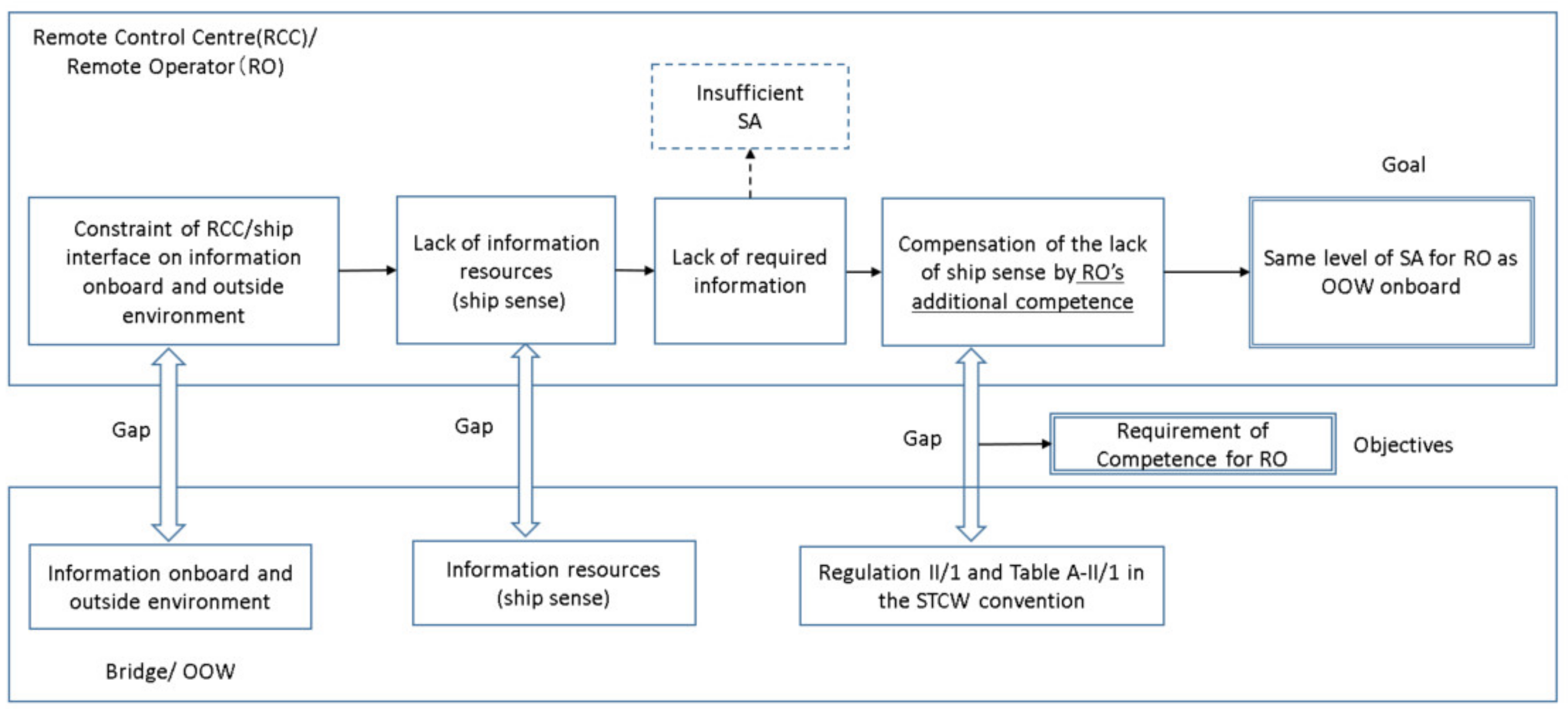
3.3. Goal-Based Gap Analysis (GBGA)

Goal-based gap analysis (GBGA), constructed in the present research, integrates the goal-based method and gap analysis (see Figure 2).
The first step of GBGA is to set a goal that is clear and easy to understand. Theoretically, a high level of autonomous ships might enable to decrease the workload of RO since the autonomous system, such as autopilot, can replace some of the navigation tasks. If the automation system has some decision-making ability on its own with higher and sufficient reliability in the future, RO can trust the system and decide with low SA [14]. Nevertheless, it is expected that RO will be sought to retain the high level of SA for deciding with confidence, e.g., in case of sudden overtakes of the task from the autonomous system. In fact, Sætrevik and Hystad [30] suggest that navigators who retain better quality SA tend to decrease the chance to face accidents because they are aware of and control the critical condition more comfortably. Their study also points out that the poor SA is ‘a sharp end causal factor’ for human error. Ahvenjärvi [31] stresses that SA should be maintained during remote control. DNVGL further suggests that RO should retain the same or better level of SA despite the lack of ‘human sense’ [32]. Taking these into account, it is appropriate to set the goal as to keep the same quality of SA for RO as OOW onboard a ship.
The second step is to identify the goal constraint, which is almost the same as the goal obstacle, which Anton [33] defines as ‘behaviours or other goals that prevent or block the achievement of a given goal’. The beginning of goal constraint in Figure 2 is the restriction on the interface of the information between RCC and the environment inside/outside the bridge of a ship because of, for example, the limit of data communication capacity. This restriction leads to the lack of information resources, especially ship sense, i.e., RO will have limited ship sense [34]. The lack of information resources connects the lack of required information for each SA. High level of lack emerges as the difficulty of ROs for being engaged in the navigational watch (RQ1 in Section 1) arises.
Once the goal constraints are identified, the next step is to set measures to overcome the limitation and keep the provided goal. Since the present research focuses on the competence of RO, it adopts the acquisition of additional competence as a solution to supplement the lack of ship sense.
Finally, regulatory requirements on competence for RO will be identified by utilising the provisions of the STCW Convention. These additional competence and regulatory requirements, especially regulatory requirements, are the answers of RQ2 in Section 1.
Through all stages, gap analysis is used. Maritime UK [5] recommends HAZard and OPerability studies (HAZOP) to develop training materials for MASS operators, including ROs. The gap analysis of workshop-type is used to compare the current training level with further training requirements. Mindykowski [35] utilises related accidents that happened in the past to analyse the relationship between the cause of the accidents and the lack of competence on a power plant in a ship. Sharma et al. [36] use a questionnaire survey to OOW of commercial vessels. The method by Rosenberg et al. [37] is to measure the gaps in paediatric practice training through a focus group discussion. Although there are various methods for gap analysis, one of the key points is to involve experienced experts who have enough knowledge, in this case, on competence-based assessment and training described in the STCW Convention as participants of the discussion.

3.4. Competence-Based Assessment and Training in the STCW Convention

International requirements on qualification and training of seafarers are regulated in the STCW Convention. The STCW Convention was first adopted in 1978 and entered into force in 1984 (STCW78). STCW78 described the minimum knowledge required for certificating officers and ratings but did not include detailed criteria. After some tremendous shipping accidents, IMO started reviewing the Convention [38]. Finally, the amended Convention was adopted in 1995 and entered into force in 1997 (STCW95). The revised one primarily modified the requirements, especially about minimum knowledge. It introduced a competence-based assessment and training scheme, which is also named ‘outcome-based’, ‘performance-based’ and ‘criterion-referenced/validated’ [38]. The minimum required knowledge regulated in STCW78 was detailed and updated under the Knowledge, Understanding and Proficiency (KUP) column. Moreover, two columns, Methods for Demonstrating Competence and Criteria for Evaluating Competence, are newly added in STCW95. Then IMO has further amended and added some parts in the latest STCW Convention (STCW2010).
One of the most important points on the introduction of competence-based training (CBT) in STCW95 is that candidates’ training became ‘outcome-based’. They should ‘demonstrate their ability’ to achieve the tasks that are required for the certification [38]. In other words, seafarers certified according to CBT are proved to take appropriate actions that are sought in their responsibilities onboard ship. Another point is that, in CBT system, training should be designed based on ‘measurable standards of performance’, assessment should be placed as an ‘essential part’ and the training and assessment should be carried out with high level of quality assessment [39]. That means that CBT allows some flexibility on the design of the training course by maritime education institutes under explicit competence, and requires the quality assessment of the training scheme as an indispensable matter.
Although there are some critics in the current competence requirements of STCW2010 that they have many concerns, including unclear and vague assessment criteria in the competence table [40], this system has recognised as a standard competence assessment and training tool in the world. Baldauf et al. [41] suggest that current provision of regulations in the STCW Convention could be the starting point for discussing minimum training standards for autonomous systems. In fact, RSE in the IMO [6] utilises the STCW Convention when considering the competence of RO and crews. Sharma et al. [20] also review the competence for OOW in MASS by utilising Table A-II/1 in the STCW Convention.
CBT in the STCW Convention requires the experience of seagoing service or onboard training for acquiring competence to be OOWs, chief mates and masters. For example, a cadet to be OOW on a seagoing ship of 500 GT or more shall receive an approved onboard training program of not less than 12 months or an approved seagoing service of not less than 36 months.

4. Method of Case Study

A case study was carried out to verify GBGA in Section 3.3 and recognise the trend on competence requirements for RO about a typical scenario. The remaining sections explain each process.

4.1. Goal-Setting

Based on GBGA in Section 3.3, the following six goals were provided for the case study. Goal 3 (G3) and Goal 4 (G4) are related to the answer of RQ1, and Goal 5 (G5) and Goal 6 (G6), especially G6, are related to the answer of RQ2.
  • Goal 1 (G1): Lists the bridge navigation items necessary for acquiring the required information for Level 1 SA.
  • Goal 2 (G2): Lists ship sense that is necessary for acquiring required information for SA
  • Goal 3 (G3): Rates the lack of ship sense by limiting data communication for visibility of the screen and sound at RCC.
  • Goal 4 (G4): Rates the lack of required information for each SA.
  • Goal 5 (G5): Lists the items on possible additional competence to compensate for the lack of ship sense.
  • Goal 6 (G6): Lists the items of competence requirements that should be added or removed from Regulation II-1 and Table A-II/1 in the STCW Convention.

4.2. Assumption-Setting

The following assumptions were provided for the study.

4.2.1. Size of Ship

The level of information required for SA is different depending on the ship size. For example, a small boat does not need long-range visibility than a sizeable oceangoing ship such as a container ship and an oil tanker. This study set the ship size of around 3000 gross tonnages (GT) since this size is the largest in the thresholds that the STCW Convention defines to qualify OOWs, masters and first mates.

4.2.2. Navigation Area, Bridge Manning and Autonomy Level

The STCW Convention requires proper arrangement for watchkeeping personnel following the situation considering the limitation of individuals’ qualifications or fitness (A-VIII/2 Part3). Based on that, the bridge manning level is provided in the Safety Management System (SMS) developed by the shipping company individually in accordance with Chapter IX of the SOLAS Convention and the ISM Code. The level decides the arrangement for watchkeeping, depending on, for instance, the navigational condition and navigation area. The style and contents have not been unified and standardised; some companies use three categorised colours, red, yellow and green. Other companies use four categorised number style [42]. As an international guide, ICS [22] shows an example of a bridge manning matrix. The matrix categorises the manning level by three factors, navigation area (port(entering and leaving), restricted water, coastal water, ocean water and anchorage), visibility (clear and restricted) and daylight (daylight, darkness and night). This study utilised ICS’s manning matrix and excluded the port area (entering and leaving) and restricted water since these areas require complicated navigation, including frequent communication with vessel traffic service (VTS) centre and other vessels and pilots. It finally chose a coastal area with clear visibility and daytime based on the project’s information described in Section 4.2. According to the matrix, the manning of this case study is the team of OOW (i.e., RO) and Lookout. Both of them were assumed to be on duty at RCC to simplify the situation.
Emergencies such as search and rescue (S&R), a fire onboard and a cyberattack were excluded from this study to avoid complex factors of watchkeeping.
It was also assumed that this case study’s autonomy level was the same as the current common ships to minimise the variables to be considered. That means that RO navigates the ship with no autonomy at RCC.

4.2.3. Constraint of Information Transmission between RCC and Bridge

The following two projects were referenced to set assumptions regarding the constraint of information transmission. Regarding visibility, this case study utilised the information on the remote control system that has been installed between the training ship (425 GT) of Tokyo University of Marine Science and Technology and RCC, and on a demonstration project that was carried out using the same ship in 2019. For the condition of audio information, another project carried out in the Japanese coastal area was referred to [43]. The outline of the visual condition on the screen at RCC and sound condition that RO can hear at RCC are shown in Table 1. It was assumed that the data of electronic navigation equipment on the bridge were simultaneously transmitted to the same type of equipment at RCC and indicated the information without any delay and trouble.

4.2.4. Competence Table and Officer’s Level

As described in Section 3.4, the STCW Convention includes mandatory competence tables that OOWs should satisfy. The tables are divided depending on crew’s qualifications; OOWs onboard a ship more than 500 GT (Table A-II/1), chief mates and masters onboard a ship of 500 GT and more and ones onboard a ship of 3000 GT and more (Table A-II/2). This study utilised the table for OOW (Table A-II/1), taking into account that it focused on watchkeeping except for ports and restricted water without emergency conditions. This study also defined the level of OOW and RO as ‘a novice (inexperienced) officer who is qualified as an STCW II/1 officer and can have a duty for watchkeeping of a ship described in Section 4.2 (e.g., officers who have graduated Maritime Education and Training Institute within two years)’.

4.3. Methodology

The present study adopted the qualitative method, in detail, the focus group discussion for securing the validity of listing and rating through the discussion [44]. The ‘Mini focus group’ discussion, which is formed in case of a small potential number of participants [45] between 2 and 5 [46] with outstanding expertise, was made to achieve each goal in Section 4.1 considering a few numbers of experts. The interview by the written Q & A and one-to-one oral interview was also done before the discussion for preparing the material for the group discussion. The mini focus group unanimously agreed on the rating and listed items as results of the case study at the final stage. Different listed items and rating by the experts in the interview were open to the group and ‘resolved through the mutual discussion’ by the experts, which was a process similar to the past study [47]. Comments in the interviews were recorded, and all summarised comments and answer sheets were provided at the group discussion for all experts. Comments during the discussion were also recorded. The comments at the interview and the group discussion were utilised for analysing the background of the results and limitation of the study.

4.4. Participants of Case Study

Taking into account the complexity of the case study that combines the consideration of the possible international regulation changes as well as ship sense and SA in MASS, experts were chosen according to the following five criteria to acquire sufficient results:
  • Experts who have experience of being involved in the consultation on regulations of the STCW Convention, such as the international discussion including IMO’s meeting (e.g., Sub-Committee on Human Element, Training and Watchkeeping (HTW)), since they should have profound knowledge including background and recent development on the IMO’s regulations;
  • Veteran trainers who have profound experience in a management position for onboard training in the training ships to teach cadets since they should objectively know various novice OOWs’ general characteristics and level;
  • Non-retired seafarers on active duty since their experience and knowledge should not be outdated;
  • Experts who have knowledge of autonomous technologies since they should easily recognise the discussion on MASS;
  • Qualified masters over 3000 GT in the STCW Convention (Regulation II/2) since they should have profound knowledge of navigation.
As a result, a total of three (3) experts who meet the above criteria participated in the case study. All of them have taught cadets for 15–22 years onboard various training ships, including more than 6000 GT, in Maritime Education and Training Institution (METI). They also have experience of being involved in the consultation process for developing the STCW Convention, including RSE of MASS at Maritime Safety Committee (MSC).

4.5. Process of Mini Focus Group Discussion and Interview

At first, the experts received the explanation on this case study, including its objective, human behaviour model and GBGA model, goal, methodology, assumption and questions, using online meeting schemes (e.g., Microsoft Teams and Zoom) or face-to-face.
Second, the experts visited the RCC in Tokyo University of Marine Science and Technology, and recognised the level of visibility of the screen for remote control by watching the actual screen that is connected with the bridge of the berthed training ship, and the recorded video of the demonstration project (see Figure 3).
Third, the questionnaires (see Table 2 about questions to experts) based on the goal in Section 4.1 were sent to the experts. After receiving the answer sheets, the interview was conducted face-to-face or using an online meeting scheme to mainly ask the background of the answers.
Fourth, the mini focus group discussion was carried out twice by using an online meeting scheme. As described in Section 4.3, the answer sheets and the summarised comment papers were prepared for the discussion. The results of Q1 to Q5 were agreed upon in general after the discussion in the first round. Q6 to Q7 were also discussed. In the second round, the results of Q1 to Q5 were confirmed and agreed on. Then the group discussed Q6 to Q7 and agreed on the results. All results were confirmed by the corresponding base. All agreements were unanimous and based on consensus by all experts.

5. Results

The results of the case study are shown in the following sections.

5.1. Bridge Navigation Items Related to Required Information for SA (Q1 in Table 2)

Table 3 shows the results of the case study on the bridge navigation items that OOWs use for acquiring SA under the condition described in Section 4.2. This table was simultaneously discussed with the matter in Section 5.2 in the mini focus group. Since there was no additional comment on the provided draft during the interview, the experts confirmed the list two times in the group, before discussing G2 (Section 5.3) and at the final stage of the study, and finally agreed on it.

5.2. Linkage between Bridge Navigation Items and Required Information for Level 1 SA (G1 in Section 4.1 and Q2 in Table 2)

The required information utilised in this case study is partly rearranged from the study by Sharma et al. [20]. Based on the results of the interview, the experts discussed in the mini focus group how the bridge navigation items in Table 3 are utilised for acquiring each required information for Level 1 SA, provided the linkage sheet, and agreed on it. Table 4 sums up the results. The items were limited to the ones that OOWs actively use for acquiring the required information for Level 1 SA (perception) ‘at this moment’ under the assumed condition in Section 4.2 because the results would diverge depending on the time duration for perception and situation. ECDIS supplies a wide range of information resources (e.g., position, speed, target location). AIS information displayed in ECDIS and ARPA is also utilised to acquire many items of required information. On the other hand, there are a few types of bridge navigation items that supply specific information resources. For instance, a magnetic compass gives only magnetic compass course information. Some information resources consist of a combination of information from multiple pieces of items. For example, the information resource to precipitate the location of navigation hazards is gathered from seven items (ECDIS, ARPA, Gyro Compass, AIS/Radar, VHF, NAVTEX and Chart).
Table 5 extracts the required information to which two or more bridge navigation items are related from the agreed linkage sheet. This suggests that OOWs acquire required information in multiple ways utilising various bridge navigation items.

5.3. Linkage between Required Information for Level 1 SA and Ship Sense (G2 in Section 4.1 and Q3 in Table 2)

Table 6 shows the relationship between the required information for Level 1 SA and the ship sense. The experts discussed in the mini focus group whether the ship sense listed by each expert in the interview was reasonable and there was additional ship sense, and agreed on all items. All information required for Level 1 SA is linked to ship sense except VTS-related information; i.e., OOW needs ship sense to some extent to acquire almost required information for Level 1 SA. The necessity of ship sense decreases dramatically in Level 2 and Level 3 SA to nothing. They suggested that the information needed for these levels is made of Level 1 SA.

5.4. Lack of Ship Sense and Required Information for SA of RO (G3 and G4 in Section 4.1 and Q4 and Q5 in Table 2)

As described in Section 3.3, the required information for SA of RO has a shortage due to the constraint of transmission of the information on environment inside/outside the bridge of a ship to RCC. The experts discussed in the mini focus group how they rate each item of ship sense and required information based on the results of G1 and G2 and the interview, and agreed upon them. Table 7 is the matrix of lack of ship sense and lack of required information for Level 1 SA. Each lack was rated on a three-point scale (A-large, B-middle and C-low for ship sense, and 1-critical, 2-middle and 3-low for required information for Level 1 SA). The category of ‘lack of ship sense’ indicates the sensitivity of ship sense against the restriction of the data transfer. For example, if RO can easily feel ship sense even by rough visual screen, the lack is small. The results show that ship sense is failed at least at the middle level (B-middle); i.e., participants feel that the restriction of data transmission affects ship sense at a high level.
The lack of required information indicates the need of ship sense in the total information resources to acquire the required information. VTS-related information is removed from this matrix since these items do not connect ship sense (see Table 6). The need for ship sense is not high if the lack of required information is low even with a high level of the lack of ship sense. For example, RO has a shortage of ship sense on sea temperature (No. 17 in Table 7) since it cannot feel the temperature at RCC. However, information on the temperature required for Level 1 SA decreases very little since most information is gathered from the item on the bridge (thermometer) at RCC. Nevertheless, each item’s level of the required information is generally the same as or almost similar to one on information resources (e.g., Level A-Level 1, Level A-Level 2) and keeps a high level. The items regarding the target are incredibly high (Level A-Level 1).
Table 8 shows the lack of required information for Level 2 SA. Experts suggested that RO would have a high shortage of required information, especially on items related to target ships. Level 3 SA has similar results to Level 2 SA (see Table 9). The items pertaining to target ships and congestion mark a high level of shortage of required information. Planned visibility is also at the highest level.

5.5. Additional Competence and Possible Change and Impact on Competence Requirements for RO (G5 and G6 in Section 4.1 and Q6 and Q7 in Table 2)

Additional competence that RO should have to compensate for the lack of required information described in the last section is listed in Table 10. The experts discussed whether the listed competence extracted during the interview is linked to the results in the last section and agreed on them with adding one more competence (Item 8 in Table 10). Regarding the linkage, they expressed the opinion that the additional competence listed in the table cannot be applied to a specific item of required information but rather to multiple or whole items.
The experts elaborated Table A-II/1 in the SCTW Convention on whether the additional competence for RO affects the current competence requirements from three perspectives:
  • ‘X’: Competence in Column 1 based on KUP in Column 2 in Table A-II/1 for RO cannot be acquired without competence in Table 10. That means that detailed competence requirements in Column 2 marked ‘X’ have the possibility to be increased.
  • ‘V’: Competence in Table 10 cannot be acquired without competence in Column 1 based on KUP in Column 2 in Table A-II/1 for RO. That means that competence requirements in Column 2 marked ‘V’ increases their importance for RO to acquire additional competence.
  • ‘Z’: Competence in Column 1 based on KUP in Column 2 cannot be performed for RO due to the lack of required information for SA at RCC. That means that detailed competence requirements in Column 2 marked ‘Z’ have the possibility to be removed.
The results are shown in Table 11. They made the following suggestion.
  • A few items should possibly strengthen the requirements in KUP of Column 2 by adding detailed competence (items marked as ‘X’). These can be categorised into three parts:
    (1)
    Navigation competence utilising electronic navigation equipment, ‘Electronic systems of position fixing and navigation,’ ‘Radar navigation’ and ‘Navigation using ECDIS’.
    (2)
    Bridge resource management and leadership competence, ‘Bridge resource management’ and ‘Application of leadership and teamworking skills’ and
    (3)
    Other competence, ‘Terrestrial and coastal navigation’ and ‘watchkeeping.’
  • The inclusion of the above requirements should assess the inclusion of all additional competence in Table 10 except the followings:
    Terrestrial and coastal navigation’ and ‘Electronic systems of position fixing and navigation’ should assess the inclusion of the additional competence on Item 1 and 2 in Table 10, and
    Radar navigation’ should assess the inclusion of the additional competence on Item 1 to 7 in Table 10,
  • Many competences in the current requirements are essential for acquiring the additional competence in Table 10 (items marked as ‘V’), including:
    (1)
    Wide range of navigation competence (e.g., Terrestrial and coastal navigation, and Radar navigation) is necessary for acquiring additional competence on recognition of information, assessment of the accuracy of the information;
    (2)
    Competence on theoretical and fundamental knowledge on navigation and ship (e.g., meteorology, ship manoeuvring and handling and ship stability) is necessary for acquiring additional competence on recognition of the effect of sea circumstance on ship movement;
    (3)
    Competence on knowledge of regulatory framework including the COLREG is necessary for acquiring additional competence on risk identification of target ships and objects, and correct prediction of future circumstance;
    (4)
    Competence on the practical ability to use electronic navigation equipment such as ECDIS and ARPA/Radar is necessary for acquiring additional competence of taking back-up action in case of data interruption on the screen at RCC;
    (5)
    Competence on theoretical and fundamental knowledge on electronic navigation system on the bridge (e.g., ECDIS, ARPA/Radar and steering control system) is necessary for acquiring additional competence on identifying the cause of the trouble on electronic navigation system of MASS, and proper recognition of the alarm.
The experts also agreed that additional requirements are necessary for Item 7 and 8 in Table 10 since the current requirements do not cover data communication technology for remote control at RCC.
Regarding the relaxation of the competence requirements (items marked ‘Z’), the experts identified only the item on celestial navigation, especially position fixing skill by using a sextant.
The experts did not make an assessment on whether detailed requirements in KUP of Table A-II/1 should be added or not, although they suggested the possibility. According to them, it is because it depends on the interpretation of each requirement and has difficulty to lead a conclusion in this study.
The results of the discussion in the mini focus group on Regulation II/1 (experience of seagoing service) are shown in the last part in Table 11. The results suggest that all additional competence except competence of taking back-up action in case of data interruption of the screen at RCC needs more experience of watchkeeping onboard a ship for RO to acquire them (Items marked ‘E’). In addition, according to them, competence on data transformation in Item 7 of Table 10 cannot be covered by the experience of seagoing service of a conventional ship, and other training ways are necessary (items marked as ‘R’). In this regard, the experts suggested that the familiarisation at RCC for RO to be smoothly engaged in watchkeeping at RCC might be necessary about Item 1 to 6 and 8 in Table 10 (items marked as ‘r’).

6. Discussion

The present research aims to develop the direction to establish the appropriate regulatory requirements on competence for the shore-based RO, focusing on watchkeeping based on the STCW Convention’s regulations provision, taking characteristics and conditions of remote operation into account. Thus, it focused on RO at RCC and assessed the lack of ship sense and required information, then reviewed the additional competence and possible requirements to compensate for the shortage. The results of the case study in Section 5 through the proposed GBGA in Section 3 make some observations.
Concerning ship sense (G2), although the original element of ship sense is various, visibility outside the bridge is the most important key factor. Examples of the objects to get ship sense are landmarks such as lighthouse and buoy, forming and colour of the sea surface, cloud movement, motion of scenery and wave and encountering ships. As listed in Table 6, visibility relates to almost elements of ship sense. Although other ship sense is also necessary for getting the required information, the most part can be compensated by visibility. For instance, body balance is used for grasping the motion of a ship, such as pitching, yawing and rolling; nevertheless, these movements can also be recognised by visually capturing the change of scenery outside the bridge. It is difficult for ROs to feel body balance at RCC. Nevertheless, they can manage to be aware of the situation by utilising the remaining information resource (i.e., restricted visibility outside the bridge), as shown in Table 7. In this sense, the extent of the constraint of data transmission and consecutive visibility significantly affects SA and safe navigation. The visibility outside the bridge was relatively clear and less intermittent in the case study since the demonstration project adopts 3G or long-term evolution (LTE) (see Table 1). However, it is likely to happen that the visibility would be less clear, and a ship could not send a moving image because of the restricted data communication capacity when the ship uses the satellite communication as a data transmission tool in the ocean. In this case, the lack of visibility would be more extensive, and RO would not be able to satisfactorily be aware of yawing and rolling.
The lack of ship sense widely affects the acquirement of required information for each Level SA, as described in Table 7, Table 8 and Table 9 (G3 and G4, RQ1). The adverse effects of the lack of ship sense on the information of target ships and traffic density are comparably large through all Level SA (e.g., target speed, target location, target distance and target course for Level 1 SA, Impact of traffic condition, type of situation of the target for Level 2 SA, planned movement of the target and planned traffic congestion for Level 3 SA). This can lead to two implications. First, OOW and RO trust the information from ship sense regarding the targets and objects that might directly risk accidents. Experts indicated that they attach an exceptionally high value to ship sense and utilise the information from bridge navigation items such as ECDIS and ARPA only for confirming and supplementing ship sense. Thus, the shortage of ship sense immediately induces the failure of situation awareness. Another implication is the complexity of acquiring the target-related SA, especially in Level 2 and 3 SA. These items of SA are linked with various sources of lower Level SA although the process is not ‘linear’ but ‘dynamic’ [48]. For example, the information on the deviation between current speed and planned speed in Level 2 SA is linked mostly only with ship speed in Level 1 SA. On the other hand, an expert pointed out that OOWs and ROs need various kinds of Level 1 SA including own ship’s position and speed of the target to be aware of the situation on the impact of traffic condition. The intricate connection between different Level SA would induce uncertainty and lead to a high lack of the required information.
Regarding competence (G5 and G6, RQ2), all experts stressed that it is impossible for novice officers qualified as OOW of Regulation II/1 in the STCW Convention to have a duty of RO. The results can classify additional competence in three ways. The first additional point is the accurate recognition of the situation, including spatial awareness, appropriate prediction of future status by utilising the information from bridge navigation items and the remaining ship sense when required information is partly failed. An expert pointed out that this competence is opposite to what he has learned from instructors and taught to cadets. Crews have learned their competence for navigation in which they rely on ship sense even without electronic navigation equipment. Once acquiring this competence, they can handle the equipment well. Conversely, ROs should heavily rely on the MASS system’s navigation items at RCC with limited ship sense in many cases. The expert suggested that ROs could handle this difficult situation only when they have seagoing experience and get the navigational expertise described above. Young professionals lack the skill to ‘grasp relevant information from their environment’ under uncertain situations [18]. Experience of seagoing is essential to appropriately review the condition of the autonomous ship [49]. Considering these, ‘experience’ is the crucial item to supplement the lack of ship sense and failure of the required information. In this regard, more experience of seagoing service after being engaged in watchkeeping should be added.
The second is the competence for fail-safe. Although the case study does not cover emergency situations such as fire, collision and grounding, sudden intermittent delay of visual data is likely to happen even if redundancy has been kept. In this case, visual sense will face unusual failure. Encountering ships might be close to the ship at the same time. According to an expert, even in this situation, RO should have the competence to appropriately specify the cause of the condition and predict the next event on the screen at RCC in bounded time without panic. Although professional crews can control a ship in the ‘strategic’ way even under complicated situations based on the experience of seagoing service [19], they do not have competence for the fail-safe due to the lack of the experience of ‘visual intermittent’. Therefore, the seagoing service’s ample expertise is not sufficient for handling these situations, and another requirement on the fail-safe should be newly added to the regulation. Moreover, the training methods to get this competence are also important. Since it is difficult to make these situations in non-MASS ships, the simulation and virtual reality (VR) training will be one of them.
The next is the fundamental and theoretical knowledge of a ship, including ship motion, bridge equipment, data communication and meteorology. The abilities that RO should hold are built on fundamental knowledge. For instance, the ship’s motion changes depending on various natural elements such as speed and direction of a wind, ship condition such as ballast condition and a ship’s character such as manoeuvring characteristics, including course changing and stopping ability and ship size. Being familiar with the fundamental nature and specification of bridge equipment is also essential since manoeuvre at RCC should highly rely on the human–machine interface with the limited visual sense. Moreover, basic knowledge of wireless data communication is necessary, bearing in mind that ships will seek a ‘more comprehensive communication system’ [50]. Although officers engaged in watchkeeping currently learn most of this fundamental knowledge, RO’s competence level should be more profound.
The last is the bridge resource management (BRM), which is the regulatory requirements introduced in STCW2010 and includes ‘teamwork and leadership’ [51]. The necessity of this competence depends on the formation of bridge manning. An expert mentioned that this competence might be less critical if the RO were engaged in the watchkeeping of an unmanned ship alone at RCC. However, more profound knowledge is necessary for this study since RO and Look-out should navigate the ship as a team under restricted conditions. Moreover, the separation of the navigation crews between the bridge of a ship and RCC will make BRM much more difficult. The overlook of essential information for safety is caused by inappropriate manning [52], and BRM and leadership are indispensable competence to secure the operation of manning. Moreover, according to Kim and Mallam [34], a new leadership style, such as a non-hierarchical type connecting man and machine, might be expected. Considering these, the competence of BRM and leadership will be more critical except for a few special cases.
Although this study looks for the item that can be removed from the current requirements besides the additional requirements, the results are quite limited. This study suggests only celestial navigation, in detail position fixing skill by using sextant, since using this knowledge will not be likely to happen. However, an expert suggested that the basic concept of celestial navigation is necessary to understand.

7. Conclusions

This research improved the method to develop the regulatory frame on the competence of RO, focusing on watchkeeping on the navigation bridge under the recognition that remote control and RO are the critical elements for future MASS. It adopted the extended SA model and constructed GBGA model as a tool for developing the regulatory frame. The goal of GBGA model is set as ‘keep the same quality of SA for RO as OOW’. Then GBGA model was demonstrated by a case study in which experts were made mini focus group discussions with interviews. The results expressed the trend of ship sense on required information for each Level SA for watchkeeping, and the lack of ship sense and the failure of required information for RO, then additional competence and possible change of regulatory requirements compared to current provisions in the STCW Convention.
There are some limitations to this research. At first, this research applies one typical case on a remote control system based on the previously conducted projects. It could recognise the trend of the failure of ship sense and required information and additional requirements. Nevertheless, deferent or more detailed outputs can be found if GBGA could be applied to various MASS situations by changing assumptions, including autonomy level and operation area. Second, the case study was made by three experts. All of them are professional officers and veteran instructors, and sufficient and constructive output could be made based on the interview and active discussions. Notwithstanding, the participation of more experts will bring out additional useful comments and suggestions. Third, the measure to retain safety for MASS should take a comprehensive approach. An expert commented that the addition of competence is not enough, and it is necessary to consider the combination of RO’s competence and other factors such as bridge manning and technological innovation. He stressed, in particular, the style of watchkeeping might change according to future technology. Lastly, the competence for dealing with an emergency situation, including a fire, pirate, and cyber-attack, is also vital for safety and security. Future research should consider this matter.
Despite the above limitation, the output of this paper has useful implications. At first, the case study supports that the proposed GBGA method is a valuable tool to develop regulatory requirements for seafarers’ competence based on ship awareness. Thus, the method can be utilised as a tool not only for establishing international or national rules of RO in MASS but also for assessing whether regulatory requirements for RO are sufficient for newly introduced MASS. Second, the points that were suggested in the discussion show the whole trend of RO as described in the last paragraph. Therefore, future research on the requirements of RO can consider these points. Lastly, the results can be a basement for introducing the combination of competence requirements, the training for officials and innovative technology for MASS.
Future research on detailed consideration of competence requirements for RO under various cases is expected based on this research.

Author Contributions

Conceptualisation, M.Y., E.S. and M.S.; formal analysis, M.Y. and A.U.; investigation, M.Y.; methodology, M.Y. and M.S.; supervision, M.Y. and E.S.; visualisation, M.Y.; writing—original draft, M.Y.; writing—review and editing, M.Y., E.S., A.U. and M.S. All authors have read and agreed to the published version of the manuscript.

Funding

This research received no external funding.

Conflicts of Interest

The authors declare no conflict of interest.

References

  1. Rolls-Royce Rolls-Royce and Finferries Demonstrate World’s First Fully Autonomous Ferry. Available online: https://www.rolls-royce.com/media/press-releases.aspx (accessed on 20 August 2020).
  2. Maritime Executive Construction of Yara Birkeland Paused. Available online: https://www.maritime-executive.com/article/construction-of-yara-birkeland-paused (accessed on 20 August 2020).
  3. NYK. NYK to Participate in Crewless Maritime Autonomous Surface Ship Trial Project. Available online: https://www.nyk.com/english/news/2020/20200615_01.html (accessed on 15 July 2020).
  4. Lloyd’s Register. LR Code for Unmanned Marine Systems; Lloyd’s Register: London, UK, 2017. [Google Scholar]
  5. Maritime UK. Maritime Autonomous Surface Ships (MASS) UK Industry Conduct Principles and Code of Practice; Maritime UK: Southampton, UK, 2019. [Google Scholar]
  6. IMO. Autonomous Shipping. Available online: http://www.imo.org/en/MediaCentre/HotTopics/Pages/Autonomous-shipping.aspx (accessed on 24 July 2020).
  7. Porathe, T.; Hoem, Å.S.; Rødseth, Ø.J.; Fjørtoft, K.E.; Johnsen, S.O. At Least as Safe as Manned Shipping? Autonomous Shipping, Safety and “Human Error”; Taylor & Francis: Abingdon, UK, 2018; ISBN 978-1-351-17465-7. [Google Scholar]
  8. Abilio Ramos, M.; Utne, I.B.; Mosleh, A. Collision avoidance on maritime autonomous surface ships: Operators’ tasks and human failure events. Saf. Sci. 2019, 116, 33–44. [Google Scholar] [CrossRef]
  9. Deling, W.; Dongkui, W.; Changhai, H.; Changyue, W. Marine Autonomous Surface Ship—A Great Challenge to Maritime Education and Training. Am. J. Water Sci. Eng. 2020, 6, 10. [Google Scholar] [CrossRef]
  10. Ziarati, R.; Ziarati, M. Review of Accidents with Special References to Vessels with Automated Systems—A Way Forward; The Institute of Marine Engineering, Science & Technology (IMarEST): London, UK, 2007; p. AES07. [Google Scholar]
  11. Allen, C.H. Determining the Legal Status of Unmanned Maritime Vehicles: Formalism vs. functionalism. J. Marit. Law Commer. Cincinnati 2018, 49, 477–514. [Google Scholar] [CrossRef]
  12. Zhou, X.-Y.; Huang, J.-J.; Wang, F.-W.; Wu, Z.-L.; Liu, Z.-J. A Study of the Application Barriers to the Use of Autonomous Ships Posed by the Good Seamanship Requirement of COLREGs. J. Navig. 2020, 73, 710–725. [Google Scholar] [CrossRef]
  13. Veal, R.; Tsimplis, M.; Serdy, A. The Legal Status and Operation of Unmanned Maritime Vehicles. Ocean Dev. Int. Law 2019, 50, 23–48. [Google Scholar] [CrossRef]
  14. Endsley, M.R. From Here to Autonomy: Lessons Learned From Human–Automation Research. Hum. Factors 2017, 59, 5–27. [Google Scholar] [CrossRef]
  15. Smidts, C.; Shen, S.H.; Mosleh, A. The IDA cognitive model for the analysis of nuclear power plant operator response under accident conditions. Part I: Problem solving and decision making model. Reliab. Eng. Syst. Saf. 1997, 55, 51–71. [Google Scholar] [CrossRef]
  16. Ramos, M.A.; Thieme, C.A.; Utne, I.B.; Mosleh, A. Human-system concurrent task analysis for maritime autonomous surface ship operation and safety. Reliab. Eng. Syst. Saf. 2020, 195, 106697. [Google Scholar] [CrossRef]
  17. Endsley, M.R. Toward a Theory of Situation Awareness in Dynamic Systems. Hum. Factors 1995, 37, 32–64. [Google Scholar] [CrossRef]
  18. Chauvin, C.; Clostermann, J.P.; Hoc, J.-M. Situation Awareness and the Decision-Making Process in a Dynamic Situation: Avoiding Collisions at Sea. J. Cogn. Eng. Decis. Mak. 2008, 2, 1–23. [Google Scholar] [CrossRef]
  19. Chauvin, C.; Clostermann, J.-P.; Hoc, J.-M. Impact of training programs on decision-making and situation awareness of trainee watch officers. Saf. Sci. 2009, 47, 1222–1231. [Google Scholar] [CrossRef]
  20. Sharma, A.; Nazir, S.; Ernstsen, J. Situation awareness information requirements for maritime navigation: A goal directed task analysis. Saf. Sci. 2019, 120, 745–752. [Google Scholar] [CrossRef]
  21. Porathe, T.; Prison, J.; Yemao, M. Situation awareness in remote control centres for unmanned ships. In Proceedings of the Human Factors in Ship Design & Operation, London, UK, 26–27 February 2014; Volume 9. [Google Scholar]
  22. ICS. Bridge Procedure Guide, 5th ed.; ICS: London, UK, 2016. [Google Scholar]
  23. Prison, J.; Dahlman, J.; Lundh, M. Ship sense—Striving for harmony in ship manoeuvring. WMU J. Marit. Aff. 2013, 12, 115–127. [Google Scholar] [CrossRef]
  24. Hogg, T.; Ghosh, S. Autonomous merchant vessels: Examination of factors that impact the effective implementation of unmanned ships. Aust. J. Marit. Ocean Aff. 2016, 8, 206–222. [Google Scholar] [CrossRef]
  25. Youker, B.W. Goal-Free Evaluation: A Potential Model for the Evaluation of Social Work Programs. Soc. Work Res. 2013, 37, 432–438. [Google Scholar] [CrossRef]
  26. Endsley, M.R. A Survey of Situation Awareness Requirements in Air-to-Air Combat Fighters. Int. J. Aviat. Psychol. 1993, 3, 157–168. [Google Scholar] [CrossRef]
  27. Antonucci, L.; D’Ovidio, F.D. An Informative System Based on the Skill Gap Analysis to Planning Training Courses. Appl. Math. 2012, 3, 1619–1626. [Google Scholar] [CrossRef] [Green Version]
  28. Kaur, J.; Kumar, V. Competency mapping: A gap analysis. Int. J. Educ. Res. 2013, 1, 1–9. [Google Scholar]
  29. Brown, S.W.; Swartz, T.A. A Gap Analysis of Professional Service Quality. J. Mark. N. Y. 1989, 53, 92–98. [Google Scholar] [CrossRef]
  30. Sætrevik, B.; Hystad, S.W. Situation awareness as a determinant for unsafe actions and subjective risk assessment on offshore attendant vessels. Saf. Sci. 2017, 93, 214–221. [Google Scholar] [CrossRef] [Green Version]
  31. Ahvenjärvi, S. The Human Element and Autonomous Ships. TransNav Int. J. Mar. Navig. Saf. Sea Transp. 2016, 10, 517–521. [Google Scholar] [CrossRef] [Green Version]
  32. DNVGL. Autonomous and Remotely Operated Ships; DNVGL: Oslo, Norway, 2018. [Google Scholar]
  33. Anton, A. Goal-Based requirements analysis. In Proceedings of the Second International Conference on Requirements Engineering, Colorado Springs, CO, USA, 15–18 April 1996; pp. 136–144. [Google Scholar]
  34. Kim, T.-E.; Mallam, S.C. A Delphi-AHP study on STCW leadership competence in the age of autonomous maritime operations. WMU J. Marit. Aff. 2020, 19, 163–181. [Google Scholar] [CrossRef]
  35. Mindykowski, J. Impact of staff competences on power quality—Related ship accidents. In Proceedings of the 2018 International Conference and Exposition on Electrical and Power Engineering (EPE), Iasi, Romania, 18–19 October 2018; pp. 169–174. [Google Scholar]
  36. Sharma, A.; Kim, T.; Nazir, S.; Chae, C.-J. Catching up with time? Examining the STCW competence framework for autonomous shipping. In Proceedings of the Ergoship Conference, Haugesund, Norway, 24–25 September 2019; pp. 87–93. [Google Scholar]
  37. Rosenberg, A.A.; Kamin, C.; Glicken, A.D.; Jones, M.D. Training Gaps for Pediatric Residents Planning a Career in Primary Care: A Qualitative and Quantitative Study. J. Grad. Med. Educ. 2011, 3, 309–314. [Google Scholar] [CrossRef] [PubMed] [Green Version]
  38. Emad, G.; Roth, W.M. Contradictions in the practices of training for and assessment of competency. Educ. Train. 2008, 50, 260–272. [Google Scholar] [CrossRef]
  39. Cross, S.J. Competence Based Learning and Evaluation: Developments and Non-Developments in MET. In Proceedings of the IFSMA 33rd Annual General Assembly, Antwerp, Belgium, 24–25 May 2007. [Google Scholar]
  40. Ghosh, S.; Bowles, M.; Ranmuthugala, D.; Brooks, B. Reviewing seafarer assessment methods to determine the need for authentic assessment. Aust. J. Marit. Ocean Aff. 2014, 6, 49–63. [Google Scholar] [CrossRef]
  41. Baldauf, M.; Fischer, S.; Kitada, M.; Mehdi, R.; Al-Quhali, M.A.; Fiorini, M. Merging Conventionally Navigating Ships and MASS—Merging VTS, FOC and SCC? TransNav Int. J. Mar. Navig. Saf. Sea Transp. 2019, 13, 495–501. [Google Scholar] [CrossRef]
  42. Japan Transport Safety Board. Marine Accident Investigation Report; MA2015-3 2015; Japan Transport Safety Board: Tokyo, Japan, 2015. [Google Scholar]
  43. Shiotani, S.; Terai, K.; Ryu, X. Study on development of maneuvering support system by ship handling order from land. J. Jpn. Soc. Civ. Eng. Ser. B3 Ocean Eng. 2016, 72. [Google Scholar] [CrossRef] [Green Version]
  44. Colucci, E. “Focus Groups Can Be Fun”: The Use of Activity-Oriented Questions in Focus Group Discussions. Qual. Health Res. 2007, 17, 1422–1433. [Google Scholar] [CrossRef]
  45. O’Nyumba, T.; Wilson, K.; Derrick, C.J.; Mukherjee, N. The use of focus group discussion methodology: Insights from two decades of application in conservation. Methods Ecol. Evol. 2018, 9, 20–32. [Google Scholar] [CrossRef] [Green Version]
  46. Kamberelis, G.; Dimitriadis, G. Focus Groups: Strategic Articulations of Pedagogy, Politics and Inquiry. In Collecting and Interpreting Qualitative Materials; Sage Publications: Thousand Oaks, CA, USA, 2005; pp. 887–907. [Google Scholar]
  47. Schröder-Hinrichs, J.-U.; Hollnagel, E.; Baldauf, M.; Hofmann, S.; Kataria, A. Maritime human factors and IMO policy. Marit. Policy Manag. 2013, 40, 243–260. [Google Scholar] [CrossRef]
  48. Endsley, M.R. Situation Awareness Misconceptions and Misunderstandings. J. Cogn. Eng. Decis. Mak. 2015, 9, 4–32. [Google Scholar] [CrossRef]
  49. Felski, A.; Zwolak, K. The Ocean-Going Autonomous Ship—Challenges and Threats. J. Mar. Sci. Eng. 2020, 8, 41. [Google Scholar] [CrossRef] [Green Version]
  50. Chae, C.-J.; Kim, M.; Kim, H.-J. A Study on Identification of Development Status of MASS Technologies and Directions of Improvement. Appl. Sci. 2020, 10, 4564. [Google Scholar] [CrossRef]
  51. Röttger, S.; Vetter, S.; Kowalski, J.T. Effects of a classroom-based bridge resource management training on knowledge, attitudes, behaviour and performance of junior naval officers. WMU J. Marit. Aff. 2015, 15, 143–162. [Google Scholar] [CrossRef] [Green Version]
  52. Sandhåland, H.; Oltedal, H.; Eid, J. Situation awareness in bridge operations—A study of collisions between attendant vessels and offshore facilities in the North Sea. Saf. Sci. 2015, 79, 277–285. [Google Scholar] [CrossRef] [Green Version]
Figure 1. Flow from environment inside/outside bridge to required information.
Applsci 10 08751 g001
Figure 2. Scheme of goal-based gap analysis.
Applsci 10 08751 g002
Figure 3. (a) Screen at RCC (scenery from berthed training ship); (b) RCC at the demonstration project.
Applsci 10 08751 g003
Table 1. Visual condition on the screen at Remote Control Centre (RCC) and sound condition that Remote Operator (RO) can hear at RCC.
FactorCondition
Viewing angle of screen360°
Screen resolution1500 × 300 (pixel)
Visual Intermittency of screen5~10 s/h (Completely recover in 30 s)
Visibility of screenClear (Clear weather)
Delay of video on the screen
between Bridge and RCC
<0.1 s
Range of identifiable objects on the screen✓ A small boat one (1) nautical mile ahead
✓ A large vessel (length of 150 m) four (4) nautical miles ahead
Data communication system 3G system and LTE system
Audio quality at RCC on sound at BridgeClear
Audio delay between Bridge and RCC<0.8 s
Table 2. Questions to experts.
Question 1
(Q1)
✓ What are bridge navigation items related to ship sense and required information for SA under the assumed condition in Section 4.2?
(*) Participants were shown the draft list that the seafarer, who meets the five criteria in Section 4.4 but did not participate in the interview and discussion due to his voyage, prepared based on ICS’s Bridge Resource Procedure [22], then answered additional items.
Question 2
(Q2)
(related to G1 in Section 4.1)
✓ What bridge navigation items are necessary for acquiring the required information for Level 1 SA? Please answer the items that you actively use for acquiring each required information for perception (Level 1 SA) at that moment under the assumed condition in Section 4.2.
(*) Participants were shown the draft list that the seafarer same as Q1 prepared, then answered additional items with their causes.
Question 3
(Q3)
(related to G2 in Section 4.1)
✓ What kinds of ship sense are necessary for acquiring required information for each SA?
Please answer the ship sense that you actively use for acquiring each required information at that moment under the assumed condition in Section 4.2.
Question 4
(Q4)
(related to G3 in Section 4.1)
✓ To what extent does ship sense of RO have a shortage compared with OOW onboard a ship in case that there are constraints on the transmission of information between the bridge and RCC that are shown in Section 4.2.3 (i.e., visual information on screen and sound inside/outside the bridge (e.g., alarm from other ship) are restricted.)?
If possible, please rate the extent as your preferred way.
Question 5
(Q5)
(related to G4 in Section 4.1)
✓ To what extent does the lack of ship sense affect the required information for each SA of RO?
If possible, please rate the extent as your preferred way.
Question 6
(Q6)
(related to G5 in Section 4.1)
✓ What is the additional competence necessary for RO to compensate the lack of ship sense and keep the quality of SA?
Question 7
(Q7)
(related to G6 in Section 4.1)
✓ How should Regulation II/1 and Table A-II/1 in the STCW Convention be modified based on the additional competence in Q6?
Table 3. Bridge navigation items.
1GPS11Engine Revolution Counter
2ECDIS12Rudder angle Indicator
3ARPA/Radar13Anemometer
4Gyro Compass14Alarm of BNWAS
5EM Log15Clinometer
6AIS16Chart
7Doppler Sonar17Magnetic Compass
8VHF18Meteorological recording device
9Echosounder19Passage Plan
10NAVTEX
Table 4. Linkage between required information for Level 1SA and information resources (bridge navigation items).
No.Required InformationBridge Navigation Items
(No. in Table 3)
No.Required InformationBridge Navigation Items
(No. in Table 3)
1Ship’s position1, 2, 3, 4, 1623Speed of tidal current1, 2, 5, 7
2Speed through the water2, 3, 5, 7, 1124Direction of tidal current1, 2, 4, 7
3Speed over the ground1, 2, 3, 7, 1625Direction of wave (wind, swell)4, 18
4Gyro compass course2, 3, 426Height of wave (wind, swell)18
5Magnetic compass course1727Target location2, 3, 4, 6
6Heel1528Target speed2, 3, 6
7Rudder angle1229Target distance2, 3, 6
8Rate of turn430Target course2, 3, 6
9Pitching-31Target bearing2, 3, 4, 6
10Yawing432Number of targets2, 3, 6
11Rolling-33TSS to be followed2, 4, 8, 16
12Swaying-34VTS communication frequency2, 8, 16,19
13Surging-35VTS standing instructions8
14Under keel clearance2, 9, 1636Location of navigation hazards2, 3, 4, 6, 8, 10, 16
15Visibility-37Anchorage areas2, 3, 4, 8, 16
16Temperature1838Location of wreck, shoals, underwater rocks2, 3, 4, 10, 16
17Sea Temperature1839Density of traffic2, 3, 6
18Moisture1840Planned route2, 16, 19
19Amount of cloud-41Distance to waypoints2, 3, 4, 16
20Sky condition-42Planed speed for each leg2, 16,19
21Speed of wind (relative and absolute)1343Air draft2, 16, 19
22Direction of wind (relative and absolute)4, 13
Table 5. Detailed explanation on the relationship between required information for Level 1 SA and information resources (bridge navigation items) (in case that two or more items are related).
No.Required InformationRelationship with Bridge Navigation Items
1Ship’s positionSee the information obtained from GPS (1) as well as on the screen of ECDIS (2) and ARPA/Radar (3). Confirm the position through the distance between the parallel index and some objects (e.g., cape) by ARPA/Radar (3). Confirm the position obtained by comparing the ship bearing information using Gyro compass (4) with the information of location written in the Chart (16). Confirm the position by Chart (16) and ECDIS (2).
2Speed through the waterSee the information obtained by EMLog (5) and Doppler Sonar (7), respectively. Also see the information on the display of ECDIS (2) and ARPA/Radar (3). Confirm the speed approximately by Engine revolution counter (11) as well.
3Speed over the groundSee the information obtained by GPS (1) as well as on the screen ECDIS (2) and ARPA/Radar (3). See the information obtained by Doppler Sonar (7). Confirm the speed by periodical position fixing by Chart (16).
4Gyro compass courseSee the information obtained by Gyro compass (4), ECDIS (2) and ARPA/Radar (3), respectively.
14Under keel clearanceSee the information obtained by Echosounder (9). Confirm the under keel clearance by comparing the water depth information from ECDIS (2) and Chart (16) with maximum water draft.
22Direction of wind (relative and absolute)See the information obtained by Anemometer (13). Confirm the direction by comparing the ship bearing information obtained by Gyro compass (4) with the relative wind direction by checking wave rippling.
23Speed of tidal currentSee the information obtained by Doppler Sonar (7). Compare the information of the speed through the water obtained by EMLog (5) with one through the ground from GPS (1) with ECDIS (2).
24Direction of tidal currentSee the information obtained by Doppler Sonar (7). Compare the ship bearing information obtained by Gyro compass (4) with geographical ship direction information obtained by GPS (1) with ECDIS (2). Compare the ship bearing information obtained by Gyro compass (4) with the information on the current direction obtained by the flow of form and marine waste.
25Direction of wave (wind, swell)See the information obtained by Meteorological recording device (18). Confirm the direction by comparing the ship bearing information obtained by Gyro compass (4) with the information on the relative wave direction obtained by wave rippling.
27Target locationSee the information obtained by ARPA/Radar (3). Identify the target ships by AIS (6) on the screens of ECDIS (2), and ARPA/Radar (3). Confirm the direction of the target from the ship bearing information obtained by Gyro compass (4).
28Target speedSee the information obtained by ARPA/Radar (3). Identify the target ships by AIS (6) on the screens of ECDIS (2), and ARPA/Radar (3).
29Target distanceSee the information obtained by ARPA/Radar (3). Identify the target ships by AIS (6) on the screens of ECDIS (2), and ARPA/Radar (3).
30Target courseSee the information obtained by ARPA/Radar (3). Identify the target ships by AIS (6) on the screens of ECDIS (2), and ARPA/Radar (3).
31Target bearingSee the information obtained by ARPA/Radar (3). Identify the target ships by AIS (6) on the screens of ECDIS (2), and ARPA/Radar (3). Confirm the target bearing by checking the ship bearing information obtained by Gyro compass (4).
32Number of targetsSee the information obtained by ARPA/Radar (3). Identify the target ships by AIS (6) on the screens of ECDIS (2), and ARPA/Radar (3).
33TSS to be followedConfirm the information obtained by ECDIS (2) and Chart (16), respectively. Confirm the announcement from VTS stations by using VHF (8). Confirm the distance to the point based on the ship’s position obtained by comparing the ship bearing information using Gyro compass (4) with the information of location written in the Chart (16).
34VTS communication frequencyConfirm the information by ECDIS (2) and Chart (16), respectively. Confirm the information by Passage Plan (19) obtained from Sailing Directions. Confirm the announcement from VTS stations by using VHF (8).
36Location of navigation hazardsSee the information obtained by ECDIS (2) and Chart (16), respectively. Confirm the distance from the ship based on the ship’s position obtained by comparing the ship bearing information using by Gyro compass (4) with the information of location written in the Chart (16). Identify the hazards (e.g., virtual buoy) by AIS (6) on the screen of ECDIS (2) and ARPA/Radar (3). Confirm the information by the announcement of VHF (8) and NAVTEX (10).
37Anchorage areas
(Areas shown in the Chart and instructed by a local port authority)
See the area information from ECDIS (2), Chart (16), respectively. Confirm other ships’ information from ARPA/Radar (3). Confirm the distance from the ship based on the ship’s position obtained by comparing the ship bearing information using by Gyro compass (4) with the information of location written in the Chart (16). Confirm the information by the announcement of VHF (8) from the port authority, etc.
38Location of wreck, shoals, underwater rocksSee the area information obtained by ECDIS (2) and ARPA/Radar (3), respectively. Confirm the distance from the ship based on the ship’s position obtained by comparing the ship bearing information using by Gyro compass (4) with the information of location written in the Chart (16). Confirm the current situation (e.g., water depth and wreck) by NAVTEX (10) information.
39Density of trafficSee the information obtained by ECDIS (2) and ARPA/Radar (3), respectively. Identify the ships by AIS (6).
40Planned routeConfirm the current planned route by checking ECDIS (2) and Chart (16), respectively. Compare the current planned route in the Passage plan (19).
41Distance to waypointsConfirm the information obtained by ECDIS (2) and Chart (16), respectively. Confirm the waypoints by using Electronic Bearing Line (EBL) and Variable Range Marker (VRM) of ARPA/Radar (3). Confirm the distance from the ship based on the ship’s position obtained by comparing the ship bearing information using by Gyro compass (4) with the information of location written in the Chart (16).
42Planned speed for each legConfirm the planned speed by checking ECDIS (2) and Chart (16) compared with Passage plan (19).
43Air draftSee the height from the surface by ECDIS (2) and Chart (16), respectively. Confirm the information on the air draft in the Passage Plan (19).
(*) The functions of ARPA/Radar are assumed to the ones required in Resolution MSC.192(79).
Table 6. Linkage between required information for Level 1 SA and ship sense.
Required Information
(Level 1SA)
Ship Sense (Visibility)Ship Sense (Others)
1Ship’s position* Landmark (e.g., lighthouse, chimney, summit of mountain)
* Sight outside the bridge
2Speed through the water* Sight outside the bridge
3Speed over the ground* Motion of scenery
* Movement of form and floating objects on a sea surface
4Gyro compass course* Landmark (e.g., lighthouse, chimney, summit of mountain)
* Position of buoy
* Celestial position
* Direction to land
5Magnetic compass course* Celestial position
* Direction to land
6Heel* Motion of scenery* Body balance (labouring of a ship)
7Rudder angle* Motion of scenery* Body balance (centrifugal force)
8Rate of turn* Motion of scenery* Body balance (centrifugal force)
9Pitching* Motion of scenery* Body balance (Labouring of a ship)
10Yawing* Motion of scenery* Body balance (Labouring of a ship)
11Rolling* Motion of scenery* Body balance (Labouring of a ship)
12Swaying* Motion of scenery* Body balance (Labouring of a ship)
13Surging* Motion of scenery* Body balance (Labouring of a ship)
14Under keel clearance* Colour of sea surface
* Distance from land
* Smell (Salty air)
15Visibility* Scenery outside the bridge
16Temperature * Thermal sense
17Sea Temperature* Water vapor on the sea
18Moisture * Thermal sense (Humidity)
19Amount of cloud* Scenery outside the bridge
20Sky condition* Scenery outside the bridge* Thermal sense
21Speed of wind (relative and absolute)* Wave motion* Body sense (wind)
* Sound
22Direction of wind (relative and absolute)* Wave motion* Body sense (wind)
23Speed of tidal current* Sailing wave and sea wave
* Form on the sea surface and floating object
* Lean of a buoy
24Direction of tidal current* Sailing wave and sea wave
* Form on the sea surface and floating object
* Lean of a buoy
25Direction of Wave (wind, swell)* Wave motion* Body balance (Labouring of a ship)
26Height of Wave (wind, swell)* Wave motion* Body balance (Labouring of a ship)
27Target location* Appearance of target ships* Sound (Whistle, Engine of target ships)
28Target speed* Movement of target ships
* Ship wave
* Change of course of target ships
29Target distance* Appearance of target ships
30Target course* Appearance of target ships (e.g., bow direction)
31Target bearing* Change of course of target ships
* Appearance of target ships
32Number of targets* Appearance of target ships
33TSS to be followed* Location of the object of land or sea
34VTS communication frequency
35VTS standing instructions
36Location of navigation hazards* Location of land object (confirmation of the distance between a ship and navigation hazards)* Smell (Salty air)
37Anchorage areas* Location of land object (confirmation of the distance between a ship and anchorage areas)
38Location of wreck, shoals, underwater rocks* Location of land object (confirmation of the distance between a ship and these areas)
* Colour of sea
* Smell (Salty air)
39Density of traffic* sight outside the bridge
40Planned route* Location of land object (confirmation of the position of a ship)
41Distance to waypoints* Location of land object (confirmation of the position of a ship)
42Planed speed for each leg* Location of land object (confirmation of the position of a ship)
43Air draft* sight outside the bridge
Table 7. Relationship between lack of ship sense and lack of required information for Level 1 SA.
<Level 1>
Lack of Information Required for Level 1 SA Is Critical, and RO Is Difficult to Be Aware of Situation
<Level 2>
Lack of Information Required for Level 1 SA Is High, but RO Can Be Slightly Aware of Situation
<Level 3>
Lack of Information Required for Level 1 SA Is Low
<Level A>
Lack of Ship Sense is Large
1 Ship’s position
3 Speed over the ground
4 Gyro compass course
5 Magnetic compass course
15 Visibility
21 Speed of wind (relative and absolute)
22 Direction of wind (relative and absolute)
23 Speed of tidal current
27 Target location
28 Target speed
29 Target distance
30 Target course
31 Target bearing
32 Number of targets
16 Temperature
18 Moisture
24 Direction of tidal current
25 Direction of wave (wind, swell)
26 Height of wave (wind, swell)
17 Sea Temperature
<Level B>
Lack of Ship Sense is Middle
2 Speed through the water
6 Hee
l7 Rudder angle
8 Rate of turn
9 Pitching
10 Yawing
11 Rolling
12 Swaying
13 Surging
14 Under keel clearance
19 Amount of cloud
20 Sky condition
33 TSS to be followed
36 Location of navigation hazards
37 Anchorage areas
38 Location of wreck, shoals, underwater rocks
39 Density of traffic
40 Planned route
41 Distance to waypoints
42 Planed speed for each leg
43 Air draft
<Level C>
Lack of Ship Sense is Low
Table 8. Lack of required information for Level 2 SA.
<Level A>
Lack of Information Required for Level 2 SA Is Critical, and RO Is Difficult to Be Aware of Situation
<Level B>
Lack of Information Required for Level 2 SA Is High, but RO Can Be Slightly Aware of Situation
<Level C>
Lack of Information Required for Level 2 SA Is Low
1 Deviation between current position and planned positions
2 Deviation between current heading and planned heading
8 Impact of traffic conditions
13 Current separation between own ship and other ship
14 Type of situation (overtaking, heads-on situation, cross situation) of target
15 Type of target (e.g., cargo ship, fishing vessel)
18 Present manoeuvre of target
3 Deviation between minimum Under Keel Clearance (UKC) and current UKC
4 Validity of position, speed, heading and other indicators
5 Risk level of system related emergencies
6 Deviation between current speed and planned speed
7 Deviation between planned course and course made good
9 Impact of ship manoeuvres
10 Impact of alternation of course
11 Impact of alternative speed
12 Impact of weather condition
16 Times to closest point to approach to target
17 Bow or rear crossing range oftarget
Table 9. Lack of required information for Level 3 SA.
<Level A>
Lack of Information Required for Level 3 SA Is Critical, and RO Is Difficult to Be Aware of Situation
<Level B>
Lack of Information Required for Level 3 SA Is High, but RO Can Be Slightly Aware of Situation
<Level C>
Lack of Information Required for Level 3 SA Is Low
1 Planned position of own ship
2 Planned movement of targets
3 Planned relative separation
4 Planned traffic congestion
7 Planned visibility
5 Estimated time of arrival to waypoints
6 Planned weather condition
8 Planned wind speed
9 Planned currents or tidal stream
Table 10. Proposed additional competence for RO.
ItemAdditional Competence for RO
1Ability to recognise necessary information from a display of equipment (e.g., ECDIS, ARPA) and other items at RCC (e.g., passage plan) under the restricted condition at RCC
2Ability to confirm the accuracy of the information obtained from restricted ship sense, radar display and other items at RCC
3Correct understanding of the effect of sea condition on the motion of a ship under the restricted condition at RCC
4Ability to recognise the target ship and other objects that have the most significant risk for safety with traffic congestion under the restricted condition at RCC
5Ability to take immediate actions through the accurate recognition of the alarm under the restricted condition at RCC
6Ability to predict future situation based on restricted condition of perception and understanding at RCC
7Ability to take appropriate back-up actions when the data transfer on moving
image of the screen between bridge and RCC is interrupted
8Ability to identify the source of the problem at RCC when the electronic navigation system of MASS is in trouble
Table 11. Relationship between additional competence for RO in Table 10 and Table A-II/1 and Regulation II/1 in the International Convention on Standards of Training, Certification and Watchkeeping for Seafarers (STCW).
Table A-II/1 in the STCW ConventionAdditional Competence in Table 10 (Item)
Column 1: CompetenceColumn 2: Knowledge, understanding and proficiency12345678
Plan and conduct a passage and determine positionCelestial navigationVV---V--
-Z------
Terrestrial and coastal navigationXX -----
VV---V--
Electronic systems of position fixing and navigationXX------
VV---VVV
Echo soundersVV---V-V
Compass—magnetic and gyroVV--VVVV
Steering control systemsVVV-V-VV
MeteorologyVVVVVV--
Maintain a safe navigational watchWatchkeepingXXXXXXXX
VVVVVV--
Bridge resource managementXXXXXXXX
Use of radar and ARPA to maintain safety of navigationRadar navigationXXXXXXX-
VVVVVVVV
Use of ECDIS to maintain the safety of navigationNavigation using ECDISXXXXXXXX
VV--VVVV
Respond to emergenciesEmergency procedures--------
Respond to a distress signal at seaSearch and rescue--------
Use the IMO Standard Marine Communication Phrases and use English in written and oral formEnglish language--------
Transmit and receive information by visual signallingVisual signalling--------
Manoeuvre the shipShip manoeuvring and handling--------
--VV-V--
Monitor the loading, stowage, securing, care during the voyage and the unloading of cargoesCargo handling, stowage and securing--------
Inspect and report defects and damage to cargo spaces, hatch covers and ballast tanks --------
Ensure compliance with pollution- prevention requirementsPrevention of pollution of the marine environment and anti-pollution procedures--------
Maintain seaworthiness of the shipShip stability--V-----
Ship construction--V-----
Prevent, control and fight fires onboardFire prevention and fire-fighting appliances--------
Operate life-saving appliancesLife-saving--------
Apply medical first aid onboard shipMedical aid--------
--------
Monitor compliance with legislative requirements VV-VVV--
Application of leadership and teamworking skills XXXXXXXX
Contribute to the safety of personnel and ship --------
Regulation II/1 in the STCW ConventionAdditional competence in Table 10 (Item)
12345678
Regulation II/1
Approved OBT for the period of not less than 12 months or approved seagoing service of not less than 36 months (watchkeeping duties for the period of not less than 6 months)
EEEEEE E
rrrrrrRr
X: Competence in column 1 based on KUP in Column 2 for RO cannot be acquired without Competence in Table 10. V: Competence in Table 10 cannot be acquired without Competence in column 1 based on KUP in Column 2 for RO. Z: Competence in column 1 cannot be performed for RO due to lack of required information for SA at RCC. E: More experience of watchkeeping duties onboard ships is necessary. R: Other training ways than ‘E’ are necessary. r: Familiarisation might be necessary.
Table 12. Proposal on possible change on the STCW Convention (Summary).
Additional Requirements
Experience of seagoing service (Regulation II/1)
Fail-safe to the intermittence of data communication (Regulation II/1 and/or Table A-II/1)
Basic knowledge of wireless communication & data transfer (Table A-II/1)
Possible Strengthening of Current Requirements by Adding Detailed Competence
Bridge resource management (Table A-II/1)
Application of leadership and teamwork skills (Table A-II/1)
Terrestrial and coastal navigation (Table A-II/1)
Electronic systems of position fixing and navigation (Table A-II/1)
Watchkeeping (Table A-II/1)
Radar navigation (Table A-II/1)
Navigation using ECDIS (Table A-II/1)
Increase of Importance of Competence Requirements for In Table A-II/1 For Acquiring Competence of RO
Navigation competence (e.g., Terrestrial and coastal navigation, Radar navigation)
Knowledge of regulatory framework (e.g., COLREG)
Theoretical and fundamental knowledge (e.g., Meteorology, Ship manoeuvring and handling, electronic navigation system)
Practical ability related to navigation equipment (e.g., ECDIS, ARPA/Radar, Steering control system)
Decrease of Competence Requirements
Celestial navigation (Position fixing skill by using sextant) (Table A-II/1)
Publisher’s Note: MDPI stays neutral with regard to jurisdictional claims in published maps and institutional affiliations.

