1. Introduction
This paper presents an investigation carried out in the framework of the Ager Mellariensis research project, conducted in the Cerro de Castillo landscape located in the Alto Guadiato Valley of Cordoba, Spain (
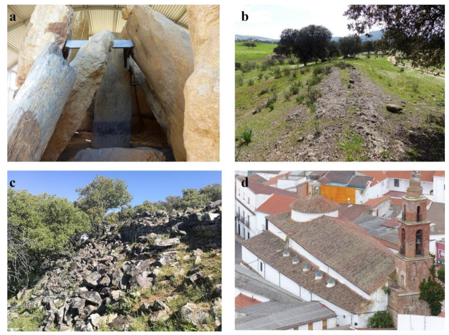
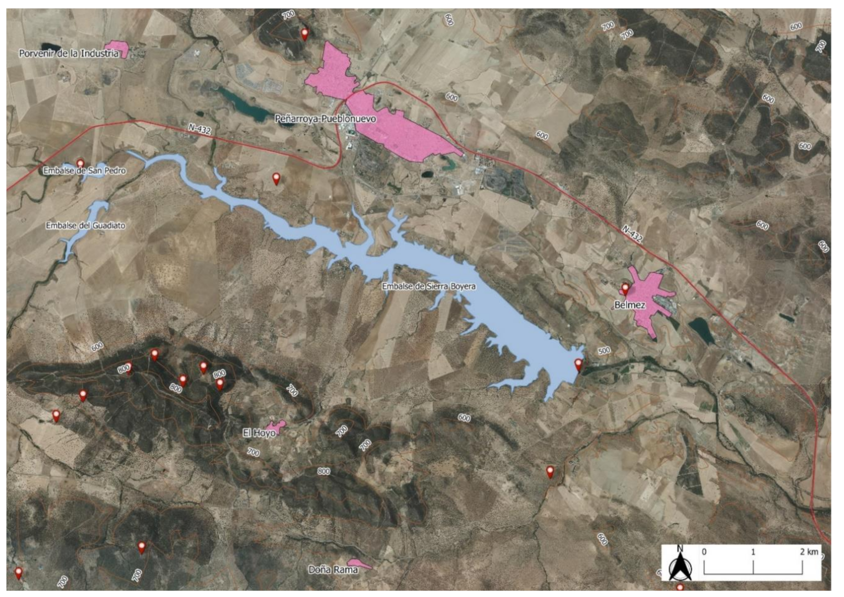
Figure 1). The study site covers an area of around 800 hectares and contains megalithic monuments, protohistoric metallurgical settlements, Roman roads, Late Antique monasteries, Andalusí fortresses, medieval castles and villages, and historical routes, as well as many native and foreign flora and fauna species that have developed over time (
Figure 2). There is documented evidence of the development of the Alto Guadiato Valley dating to the Chalcolithic period (ca. 2500 BC), when copper began to be mined, extensive agriculture was developed, the number of settlements grew, and several megalithic monuments were constructed [
1]. At that time, mining was the main industrial activity in the area, which intensified toward the end of the Iron Age (approximately 1000 BC). However, it was not until Roman times that the Alto Guadiato Valley became an important center of metallurgical activity, with the large-scale exploitation of lead and silver mines [
2,
3]. Later, in the Andalusí period (8th–12th centuries), several fortresses were erected, the population declined, and agriculture ceased to be a prominent activity. Following the Castilian conquest beginning in the thirteenth century, the lands became property of the nobility and the mining activity that had characterized the area until this time disappeared [
4,
5].
In the nineteenth century, the Société Houillère et Métallurgique de Belmez and later the Societé Minerometalurgique de Peñarroya-Pueblonuevo created the largest lead smelting complex in the world and the second most important coal mining basin in Spain. The French Quarter and the industrial complex of Peñarroya Pueblonuevo are magnificent examples of the heritage that remains from that glorious past [
6,
7].
Unlike other sites [
8], this rich cultural heritage has never been fully researched, rehabilitated, or developed as a narrative landscape until now. To recover this site, it must be interpreted as a multitemporal landscape comprised of several superimposed layers and interwoven texts [
9], from which today’s inhabitants can interpret their history and understand their cultural roots [
10].
The process of researching, protecting, and promoting this heritage while preserving its diachronic and narrative value has been a challenge for various reasons. The 800 hectares of land are of very difficult to access for the purpose of carrying out ground archeological investigations due to the existence of a reservoir, restrictions on entering private properties, and the lack of previous research projects. However, these difficulties have not obstructed our previous investigations [
11,
12,
13]. A further challenge stems from the fact that the site is located in one of the most economically disadvantaged areas of Spain, with the highest unemployment rate in the European Union. Moreover, the Alto Guadiato has no major roadways or railroads and very few museums or cultural facilities, and the protection of the area’s cultural heritage is still in a nascent stage.
There are many examples of the rehabilitation of cultural landscapes, where the sum of actions and the progressive recovery of monuments create a heritage landscape without a pre-established discourse. In other cases, there is a preparatory story [
14,
15].
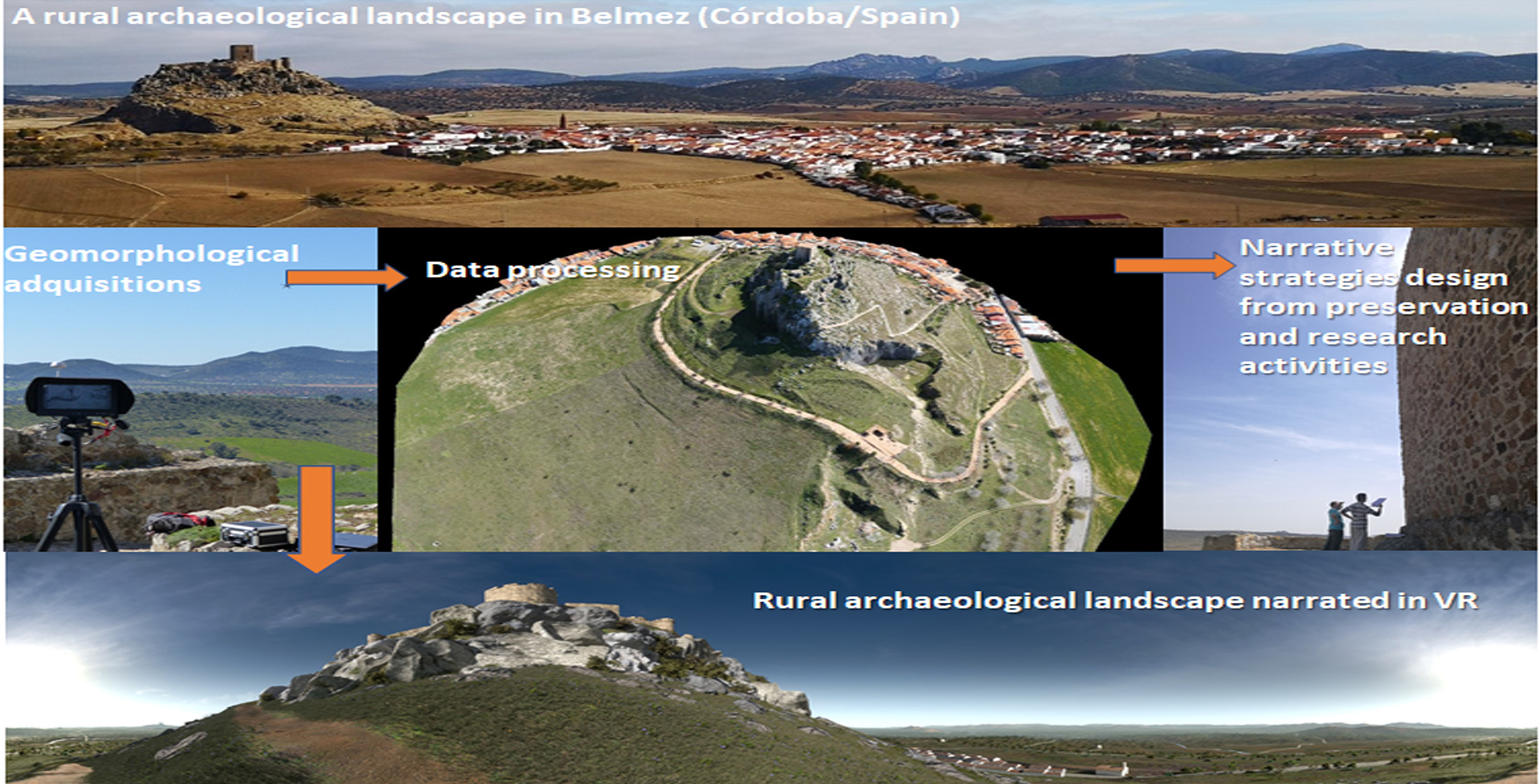
Our objective was to use state-of-the art tools and technologies to digitize heritage resources in 3D format, with a clear research, social, and discursive intention strategy. To this end, photogrammetric flights were conducted and a general inventory was made of the area’s monumental and natural resources, which served as the documentary base for the project. More specifically, the resources were digitized by means of photogrammetric acquisitions using unmanned aerial vehicles (UAVs), airborne thermal and RGB captions, and light detection and ranging (LiDAR) data from the free access IGN files. Subsequently, a monographic study was carried out for the cases that make up this landscape discourse. Regards this second objective, we were particularly interested in the most significant heritage resources located on public land, such as Belmez Castle, which is presented here as an example of the methodology used.
The social function of heritage is an essential aspect of the very notion of a cultural landscape [
16], which requires multidisciplinary and cross-cutting collaboration between various scientific and technological agents. For this reason, our research was not framed within a specific method, theme, or discipline. Rather, we have drawn on the diverse disciplines of heritage science (earth observation, remote sensing, nature conservation, archeology, and computation) as an opportunity for the social improvement of the area and the configuration of this landscape narrative, where digitization plays a fundamental role in the enjoyment, promotion, and visualization of heritage [
17].
A wide range of comprehensive actions have been employed for the recovery of heritage in rural areas of Spain [
18,
19]. Because these areas are typically characterized by a low population density and low wealth, their cultural heritage is usually not as well conserved as that of large cities or historical sites, which are generally more successful in securing funding and attracting leading research teams. As a result, the country’s rural heritage has taken longer to be defined conceptually [
20]. However, under the Research and Innovation Smart Specialisation Strategy (RIS3) of the European Union and its implementation in the region of Andalusia, heritage development has become a key instrument for rural development and a strategy to curb depopulation in these areas [
21].
This paper presents a multidisciplinary research project for the social and cultural recovery of a rural archeological landscape known as the Cerro del Castillo (CCB) located in the town of Belmez, Cordoba (southern Spain); a site that has not undergone any recuperation actions. The general strategy consisted of the digitization of the site’s material and natural heritage resources, after which the research was conducted and the results were disseminated. In the first stage of the project, photogrammetric flights were conducted over the area surrounding the CCB to obtain a geomorphological map covering more than 800 hectares. This information was then used for the volumetric recomposition of the most significant heritage elements and previously identified archeological sites [
22]. A more detailed and specific photogrammetric model of the CCB and the fortress was also obtained. Regarding the area’s natural heritage, the flora and fauna were catalogued, with the aim of protecting the species and integrating them in the general heritage discourse. Given that the castle as it stands today is the result of several construction phases, stratigraphic studies were performed to determine the building’s historical construction, damage, and rehabilitation phases. Finally, based on the research findings, a landscape of more than 60 km wide and 40 km deep was virtualized in 3D in order to protect, extend, and develop the full social potential of this archeological and natural heritage.
2. Materials and Methods
To achieve the above aims, a combination of earth observation, remote sensing, archeology, and natural science materials and methods were employed.
2.1. Earth Observation: Open Resources of the Spanish National Geographic Institute
LiDAR data acquisitions and orthophotogrammetric surveys of the Spanish National Geographic Institute (IGN-Spain) were used. LiDAR data for the entire surface of Spain are freely available and constitute an exceptional resource for aerial archeology prospection, as evidenced by their increasingly frequent use. In recent years, several archeological sites have been identified using LiDAR data from the National Aerial Orthophotography Plan of Spain (PNOA), including prehistoric settlements [
23] and Roman camps [
24], among others. The project researchers also used LiDAR data for the geoarcheological characterization of the site [
25] and to identify large Roman construction sites [
26].
From 2013 to 2014, IGN-Spain carried out a LiDAR acquisition process for the whole region of Andalusia, which completed the general LiDAR-PNOA acquisitions obtained for all of Spain, beginning in 2010. LiDAR-PNOA point clouds with a density of 0.5 points/m
2 and an altimeter accuracy of about ±20 cm of the root mean square error (RMSE) were acquired. The points were classified automatically. The LiDAR data files are presented in Log ASCII Standard (LAS) format or the Log ASCII Zipped (LAZ) format. The data are accompanied by some
Supplementary Files, including a decompression tool and visualization of the LAZ and LAS files, metadata, specifications, and a file of acquisition dates. The LAZ file can be downloaded directly from the IGN-Spain website [
27].
Updated orthoimages of Spain and Andalusia were also acquired by IGN-Spain. This geographic documentation allows several applications for the aerial detection of archeological sites in the landscape of the Alto Guadiato Valley. The digital orthophotos of PNOA flights have a pixel size of 0.25 m or 0.50 m and can be downloaded from the IGN-Spain website in Tagged Image File Format (TIFF), together with the corresponding georeferencing World File Format (TFW) files. The PNOA orthomosaics were generated by sheets at 1/50,000 and are of maximum resolution and maximum topicality in Enhanced Compression Wavelet (ECW) format. All technical parameters are available on the website [
28].
2.2. Remote Sensing: Thermal, RGB, and DTM Acquisitions
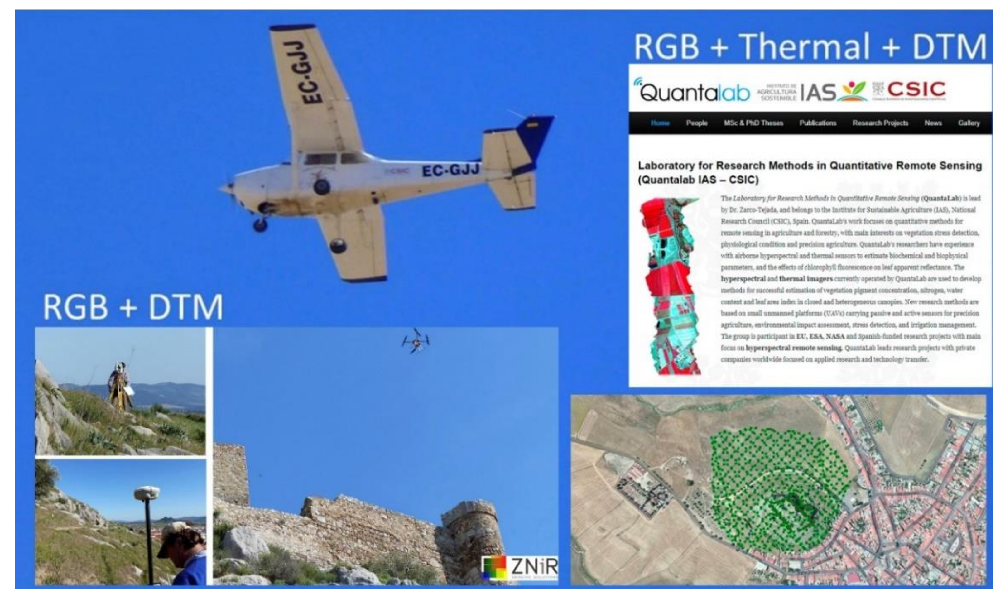
The graphic documentation of archeological heritage in Spain [
29,
30] and Europe [
31,
32] has advanced rapidly in recent years, owing to the development of consumer UAVs and user-friendly, high-performance photogrammetric software. This technology was used to conduct three photogrammetric acquisition campaigns in the surroundings of the CCB and at the top of the castle (
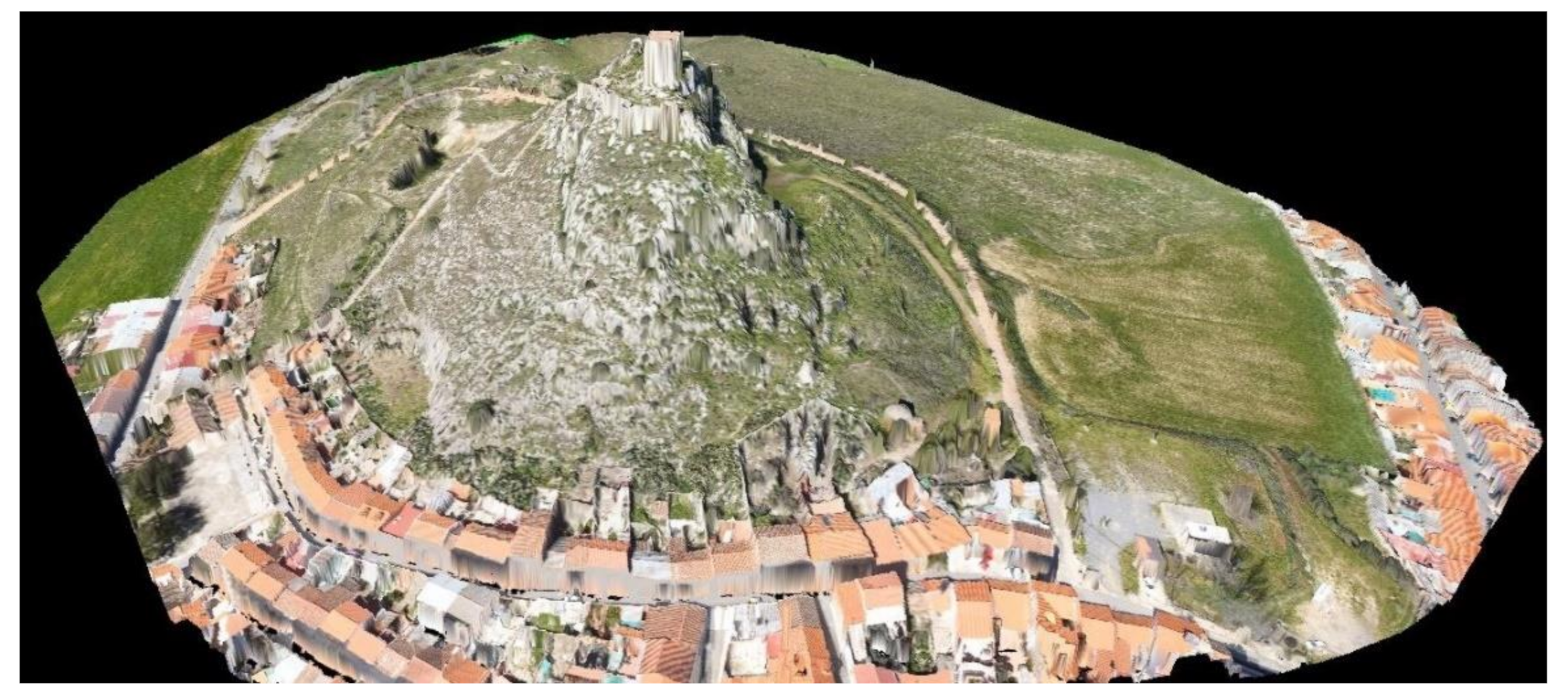
Figure 3).
The first airborne survey (30 June 2014 at 12 p.m. UTC + 01:00) covered an area measuring 1040 hectares. The survey was carried out using two sensors mounted simultaneously on board in a Cessna aircraft flying at 250 m above ground level. The first sensor was a FLIR SC655 thermal camera (FLIR Systems, Inc., Wilsonville, OR, USA) with a resolution of 640 × 480 pixels, which was equipped with a 13.1 mm F1.3 lens connected to a computer via USB2.0 protocol. The spectral response was in the range 8–12 µm. The camera was calibrated in the laboratory (Quantalab; IAS-CSIC, Cordoba, Spain) to obtain radiance values. A total of 5133 images were acquired during this survey. Orthorectification and imagery mosaicking were conducted using the structure from motion method (SfM) to obtain two thermal mosaics in Kelvin degrees with a spatial resolution of 0.37 m/px. The second sensor for this first campaign was an RGB sensor (NIKON D800E). A total of 3473 images were acquired. Orthorectification and imagery mosaicking were conducted as described above for thermal mosaic images, allowing us to obtain a very high-resolution orthophoto and a digital surface model (DSM) with a spatial resolution of 0.036 m/px.
For the second campaign, a UAV survey was performed (1 March 2016 at 12 p.m. UTC + 01:00). The UAV-based photogrammetric data acquisition campaign was conducted with a Sony Alpha 5000 20.1 MP RGB sensor mounted onboard a UAV flying at 80 m above ground level. The UAV platform was a multicopter (rotary-wing UAV). Two flights were made due to differences in the terrain elevation. The flight plans were designed in grid mode to ensure the best overlap. A total of 809 images covering an area of 22.49 hectares were acquired. Seven ground control points were measured with GPS to ensure the accuracy and spatial location of the model. Orthorectification and imagery mosaicking were conducted using SfM, allowing us to obtain a very high-resolution orthophoto and a DSM with a spatial resolution of 0.025 m/px.
The goal of the third campaign was to document the castle walls. A UAV-based photogrammetric data acquisition campaign (2 March 2016 at 12 p.m. UTC + 01:00) was conducted with the same Sony Alpha 5000 20.1 MP RGB sensor and the same rotary-wing UAV. The flight was performed in manual mode due to the complexity of the castle structures. A total of 441 images of the castle walls and tower were acquired. Seventy-five ground control points were measured using a total station to ensure the accuracy and spatial location of the model. Orthorectification and imagery mosaicking were conducted using SfM to obtain a very high-resolution orthophoto of all of the structures (<0.001 m/px).
2.3. From Aerial Acquisitions to Archeological Prospection: Identification Workflow
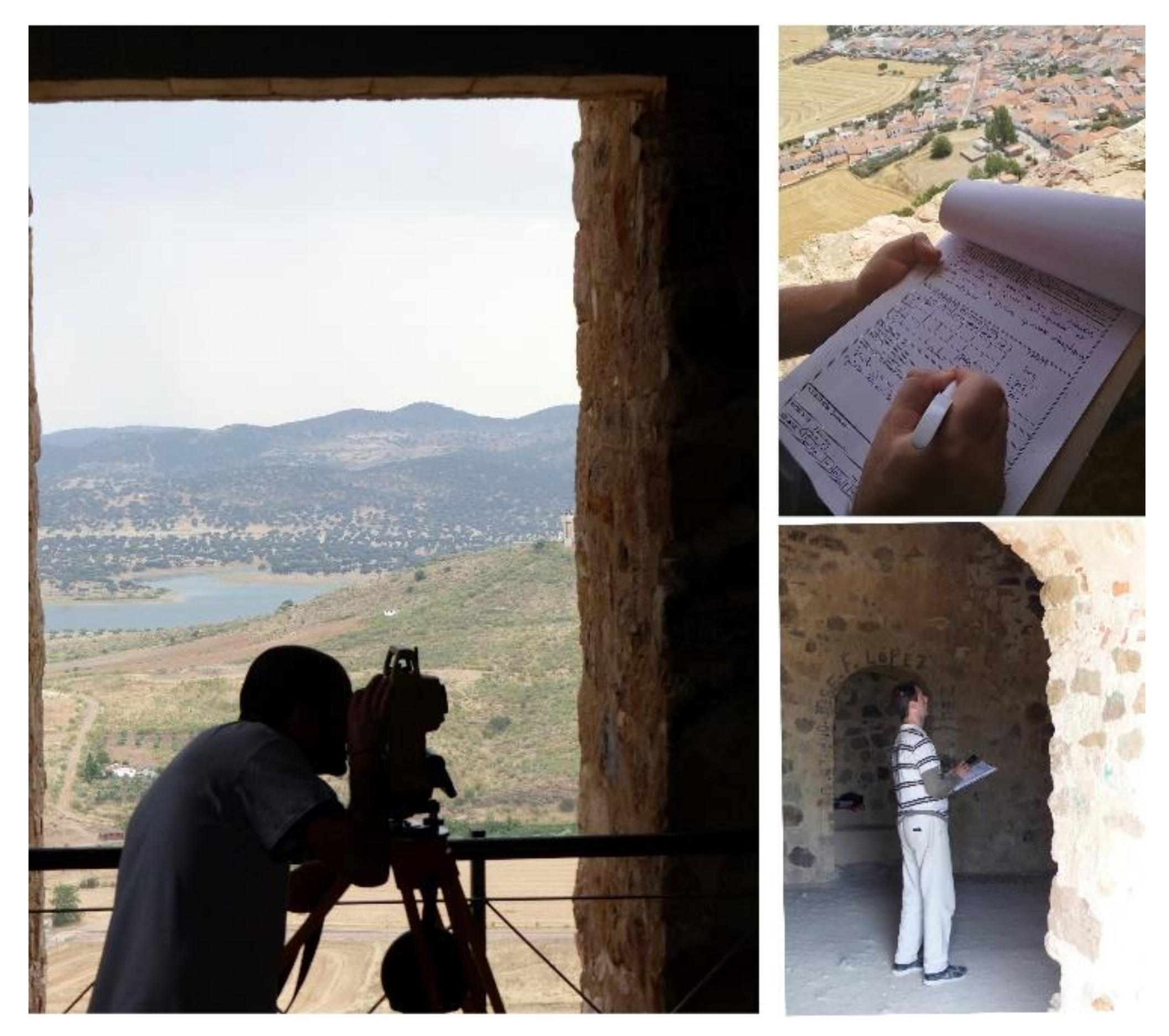
We identified several sites in the area surrounding Belmez based on the available LiDAR-PNOA data, as well as thermal flights, geophysical surveys, and ground recognition surveys. Ground prospection testing is an essential part of the process used to confirm possible new archeological sites discovered from the air.
Regarding the workflow, the first step was to assess the shapes of the newly identified sites. In prehistoric, Roman, and medieval archeology, the shapes of different settlements are well known, which allowed us to assess the veracity of the forms detected in the landscape. The second step entailed photogrammetric documentation or geophysical prospection to assess the formal characteristics of the sites in greater detail. The third step was to determine the chronology of the sites by means of ground recognition, which involved collecting archeological pieces of pottery or other materials. Finally, the fourth step was archeological excavation (
Figure 4).
There is a vast array of literature on aerial acquisition and archeological prospection, with many studies using a methodology similar to ours, which takes into account aerial analysis, photogrammetric acquisitions, geophysical surveys, and surface recognition [
33].
2.4. Archeological Stratigraphic Analysis of the Castle
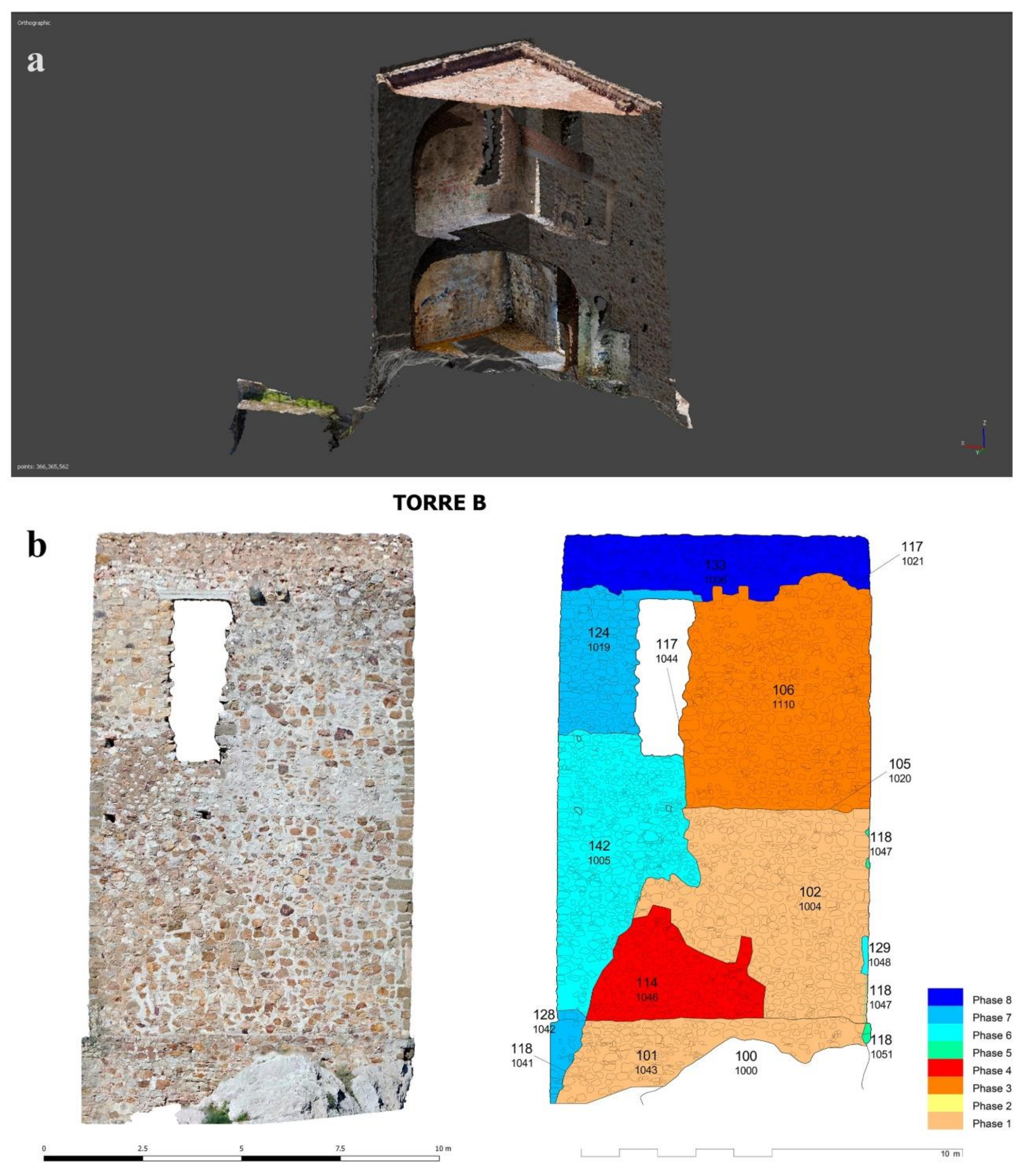
Buildings of historical interest are not the result of a single action, but rather a succession of construction and destruction that takes place throughout the building’s life. In this regard, buildings are the reflection of a sequence of transformations that include a group of construction phases, spaces, and uses that have existed, and in some cases have disappeared (
Figure 5).
The archeology of architecture framework approaches a construction site intends to explain the sequence of historical transformations, understanding the societies that built it, and determining the real structure. This methodology enables identification, differentiation, and interpretation of the temporal relationships of the different parts of a building [
34].
In addition to the stratigraphic analysis, the typology of the castle’s structural and decorative elements was determined by means of physical–chemical analyses of the building materials and analysis of written and graphic documents from the building. Archeological analysis involves individualizing the building within a single context, consisting of minimal structural entities with a three-dimensional volume or damage events represented by cuts or boundaries and characterized by their physical and technical unity, as well as a common structural purpose.
Using recording sheets and field plans, we described each unit synchronically and diachronically (i.e., the earliest and latest units) with respect to the units they have contact with to determine and reconstruct the temporal sequence of the building. At this point, a synthesis and periodization process was carried out using a matrix diagram to document the construction, reconstruction, relations, and sequencing of the stratigraphic units using the four strategies mentioned above.
2.5. Vegetation, Invertebrates, and Birds
The 23 hectares of the CCB mapped in the final photogrammetric flight were chosen for the protection and enhancement of the native fauna and flora.
For the study of the CCB biodiversity, several actions were carried out to provide an inventory of the main taxonomic groups. Specifically, the hill surface was subdivided into three units: (1) pastureland; (2) rupicolous habitats containing different slopes, shrubs, and small trees; (3) the walled area of the castle, which was the most anthropized area. The three units were sampled in 49 sessions from September 2017 to June 2018.
To monitor and quantitatively study the biodiversity of the CCB and the hill on which the castle is located (7.3 ha), various sampling methods were required. For the invertebrates, which is the most diverse group with the largest number of living forms in the area, 18 transect lines of 600 m were used, primarily to sample insects (mainly Lepidoptera, Odonata, and Coleoptera). To capture other edaphic insects that were not detected in the transects, pitfall traps baited with attractant (beer, wine, or vinegar) diluted in water (10%) were used. Twenty pitfall traps were placed in each habitat unit at a linear distance of 10 m. These traps are an excellent tool for detecting the presence or monitoring the activity of edaphic arthropod communities and performing phenological studies over the short or medium term.
To detect other groups of non-arthropod invertebrates (mollusks) or non-insect arthropods (crustaceans, arachnids, etc.), eight search sessions were carried out in situ, involving looking under rocks, sieving through leaf litter, and searching at the bottom of shrubs or in rock crevices.
For the detection of birds, observation sessions were carried out from strategically located lookout points using a telescope to identify all possible species, as well as from listening stations to identify other species by song or call. Reptiles, amphibians, and mammals located during the invertebrate sampling were also identified. For mammals, bones or skulls located during the sampling or in the pellets of birds of prey were also analyzed, as well as tracks or any other trace of their presence or passage (hair, feces, prey invertebrates or vertebrates, burrows, dens, daybeds, etc.).
For the flora inventory, 12 transects were used (four in October 2017 and eight from April to June 2018) to identify as many of the dominant herbaceous species as possible in the pasturelands and rocky habitats of the study area. Species requiring a microscopic structure study for their identification were collected, labeled, and herborized on sheets.
3. Results
3.1. Geomorphology and the Identification of New Archeological Sites
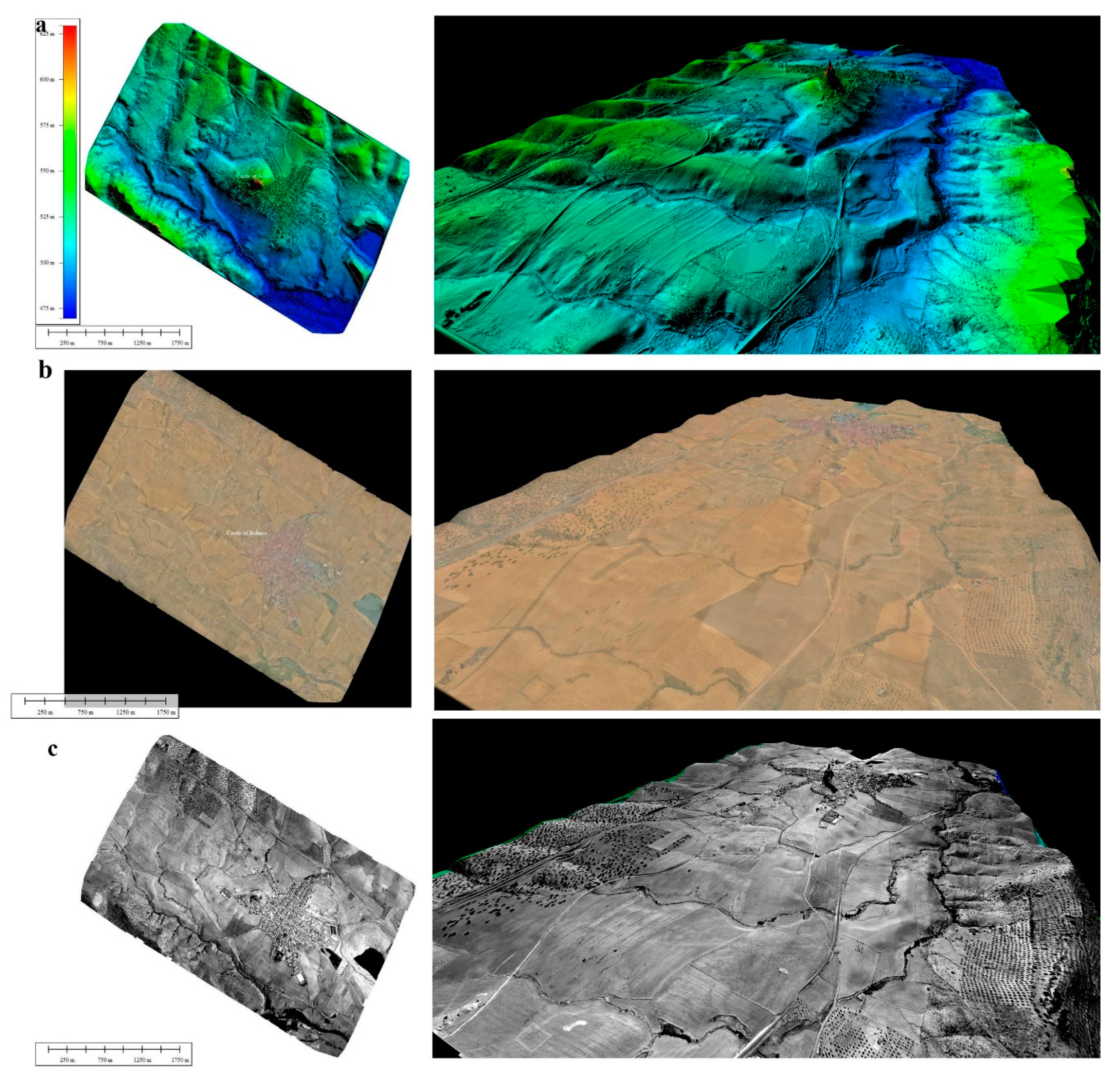
The general and specific photogrammetric flights made over the CCB landscape allowed us to discover new sites, define the geomorphology of this environment, and characterize already known sites more precisely (
Figure 4).
In the landscape near the CCB, thermal sensors revealed the course of the Roman road running from Corduba to Mellaria. From literary sources dating to the Roman period, it is known that the first stretch of this road reached Mellaria, which is only about 8 km from Belmez. However, the exact location was previously unknown and we were able to document a stretch of about 500 m that crosses the entire town of Belmez [
35].
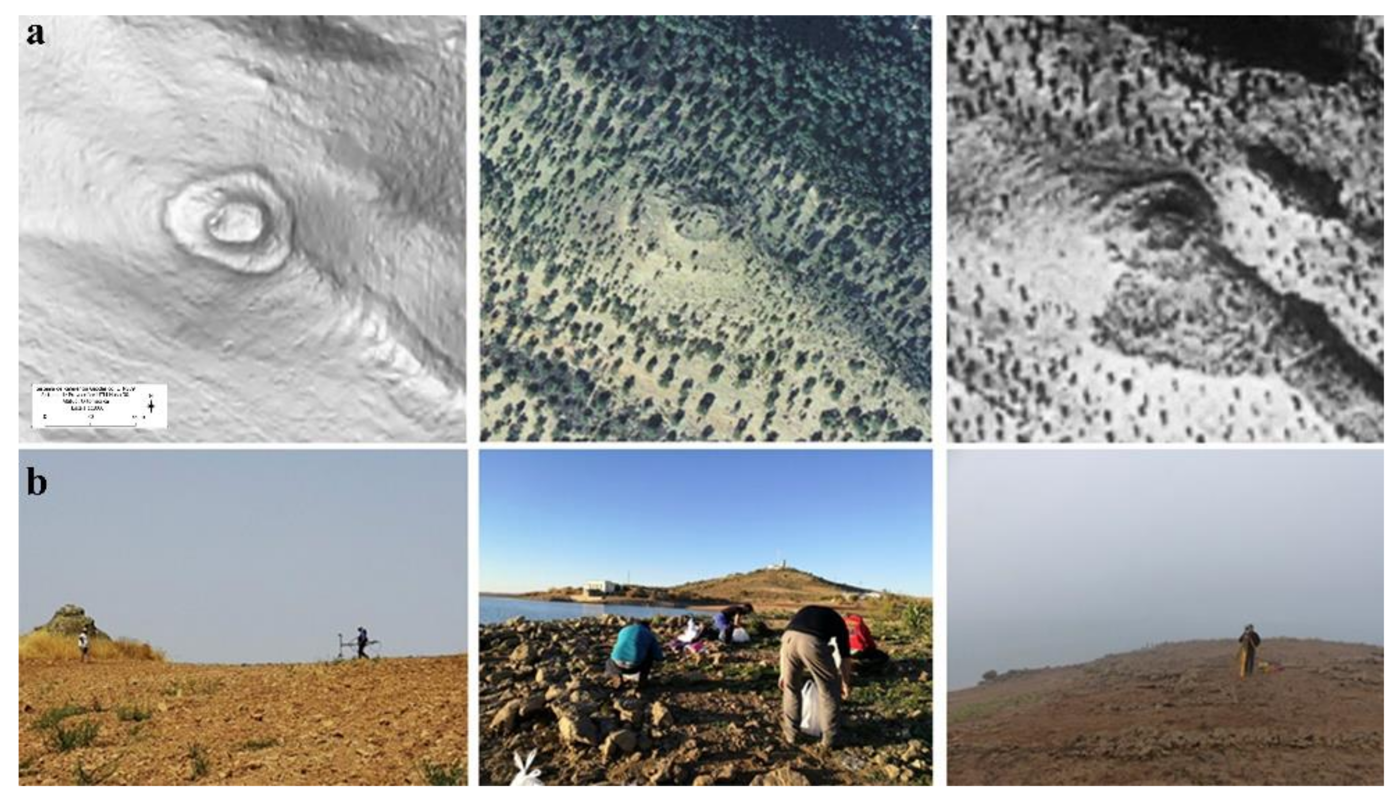
Other significant findings (
Figure 6), such as a series of previously unknown archeological sites located in the Sierra de los Santos just opposite the CBB in the central part of the landscape, were also identified by remote sensing. Although some sites dating to the Chalcolithic period were known, previously unknown settlements of pre-Roman, Roman, and medieval origin were documented by means of photogrammetric and airborne LiDAR-derived data.
Archeological prospections or excavations (
Figure 7) were conducted in some of the sites to determine their exact chrono-cultural adscription. As a result, the entire hilly sector located opposite the CCB was investigated and integrated into the virtual resources presented below. Finally, the photogrammetric and LiDAR flights also permitted the geomorphological characterization of this landscape, where water courses, extinct roads, and alterations due to mining activities in the nineteenth and twentieth centuries were detected (
Figure 8 and
Figure 9).
All of these landmarks, which date from 2500 BCE to the twentieth century, allowed us to construct our narrative discourse.
3.2. The Structural Historical Sequence of the Castle of Belmez
According to previous documentation, the tower of Belmez and its surrounding walls are the product of successive reforms in the thirteenth and fifteenth centuries. The most recent reforms were carried out in the nineteenth century during the French occupation [
36,
37,
38]. To further contribute to the current state of knowledge, we performed a stratigraphic analysis within the framework of the archeology of architecture to identify the historical sequence of the structure’s construction.
The tower is the result of an extensive sequence of construction and demolition phases, the results of which do not correspond to a single unified project (
Figure 10). The main sequence of the tower can be divided into eight phases, of which the last four date to the twentieth century. In this period, different interventions were undertaken to consolidate the tower following damage to structure suffered in the early 1950s.
The lower body of the tower corresponds to the original project (phase 1), which, after adaption of the rock, now stands on a stepped plinth. Its structural characteristics present features typical of Castilian architecture in the region, so we do not believe that it is dated prior to the thirteenth century.
The structural differences observed between the lower and upper bodies of the tower allowed us to identify the effect of early damage (phase 2) that destroyed the roof of the main room and the original upper parts. The characteristics of the upper body contain new material features that allow us to propose that the tower was rebuilt in the late Middle Ages (phase 3).
In modern times (phase 4), during the War of Independence (1810–1812), French troops were stationed in the castle and adapted it to their needs, especially the surrounding wall. At the end of the French occupation, the tower ceased to be inhabited and at the end of the nineteenth century the surroundings were subject to mining activity and a period of abandonment (phase 5), which led to new damage to the tower.
In the early 1960s, the first work to consolidate the tower was carried out by the architect Félix Hernández (phase 6) using traditional techniques. At the beginning of the twenty-first century (phase 7), the reconstruction work on the upper body of the tower was carried out by the architect Antonio Castro Escobar, whose project included closing the southern facade with masonry on an internal structure of concrete beams. The protection given to the edge of the tower terrace corresponds to a very recent renovation phase (phase 8).
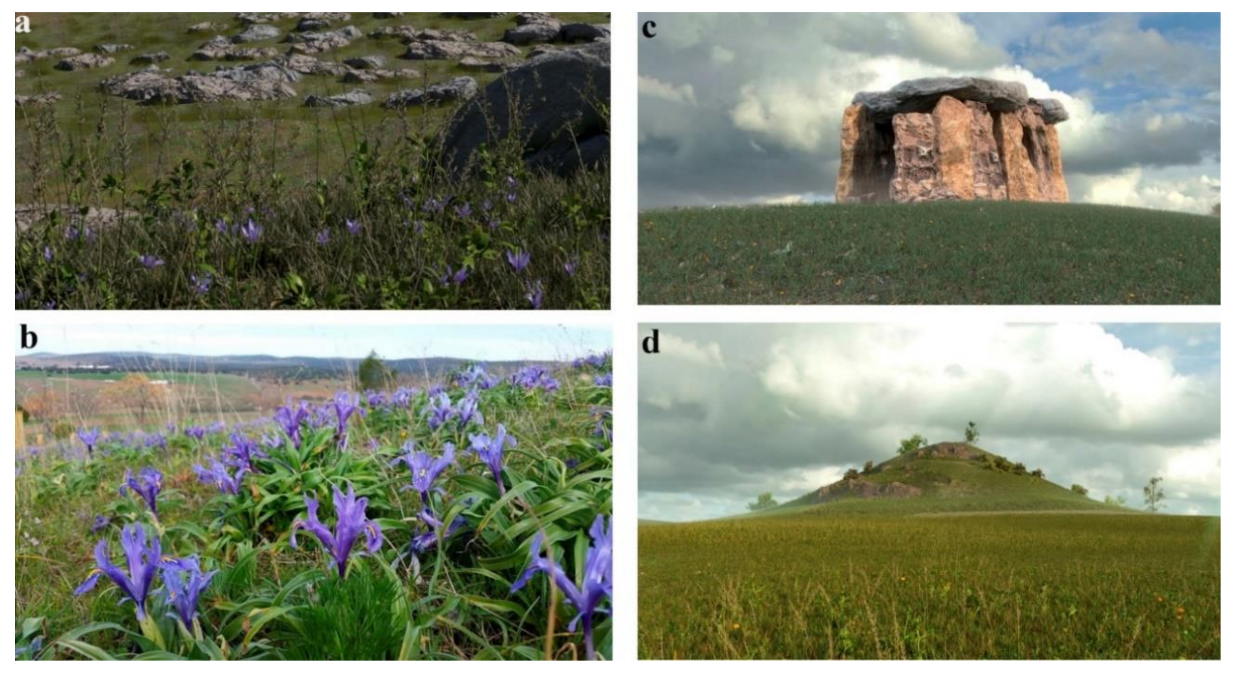
3.3. Catalogue of Flora and Fauna
The natural heritage surrounding the castle of Belmez stands out for its rich biodiversity. The area’s flat landscapes, valleys, and limestone and quartzite mountains are home to a huge variety of habitats, which form the foundation of its enormous biological diversity.
A total of 357 species were catalogued during the sampling. The flora, of which 133 species were identified, is well represented in the study area. The structure and the successional state of the plant communities comprised of these primary producers facilitate the presence of phytophagous species that depend on these plants. Regarding the vertebrate fauna, birds are the group with the largest number of recorded species (67). The CCB stands on a limestone outcrop containing a very interesting community of rupiculous birds, two pairs of Eurasian kestrels (Falco tinnunculus), one pair of blue rock thrushes (Monticola solitarius), and a large colony of Alpine swifts (Tachymarptis melba), the latter of which is one of the largest breeding populations in the province of Cordoba.
In addition, eight species of reptiles, three species of amphibians, and four species of mammals were documented, particularly the Egyptian mongoose (Herpestes ichneumon), red fox (Vulpes vulpes), and European hedgehog (Erinaceus europaeus).
Among the invertebrates, the class Insecta is the most diverse and widely represented group in the study area with 122 species. Coleoptera, Lepidoptera, and Hymenoptera are the most abundant orders of insects with 52, 27, and 18 species, respectively. The lack of water sources is a limiting factor for the presence of many aquatic species that have not been detected in the castle’s surroundings but are present in the nearby rivers, ponds, and springs.
Among the insects, the presence of the endemic Iberian mantid Apteromantis aptera is notable. This insect is included in Appendix II of the Bern Convention and Annexes II and IV of the Habitats Directive, and has been considered a strictly protected species under Spanish legislation since 1988. This new finding increases the few sites (currently ten) where this species is present in the province [
39,
40,
41].
4. Discussion: A New Experience in Immersive Virtual Reality for an Enriched Landscape
Our investigations have identified a large number of very important archeological sites surrounding the Castle of Belmez. The new megalithic monuments we have identified confirm the intense construction activities coinciding with the beginning of intensive agriculture in the area. Prior to our research, the megaliths were perhaps the most well-known monuments.
One of the most important advances in terms of our knowledge of this landscape has been the discovery of a Tartessian site in Sierra Boyera [
11], which was dated to 7 BC. This is a metallurgical settlement that links the Copper Age with the Iron Age in this area. Just opposite this settlement, also in the Sierra Boyera Reservoir and throughout Sierra de los Santos, we have discovered other previously unknown settlements located next to lead and silver mining veins. These deposits (
Figure 4) demonstrate the intensification of industrial activity in Roman times. Another important finding was the discovery of the Corduba–Emerita road [
35], which originally ran in front of the castle of Belmez. The Roman road crossed the entire territory and served as a strategic and logistical nexus for the exchange of goods between the cities of Cordoba and Merida. The prehistoric and Roman sections of this road are some of the most well preserved.
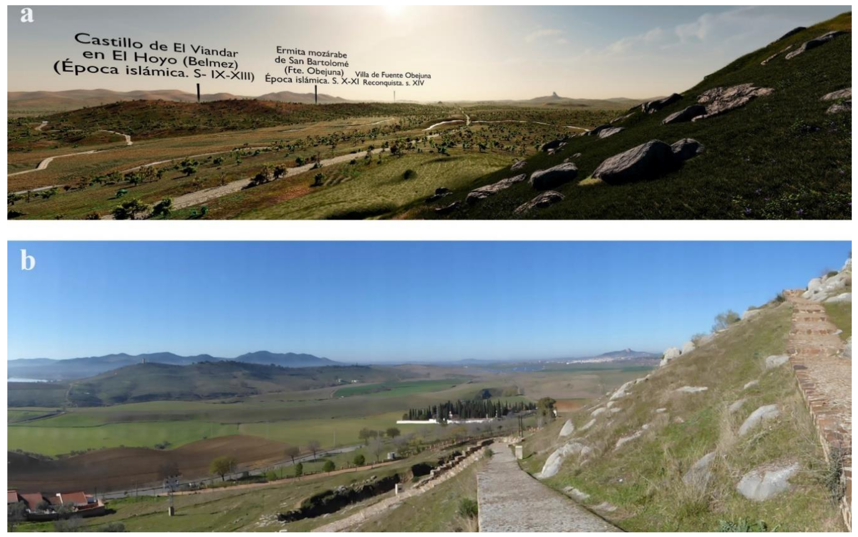
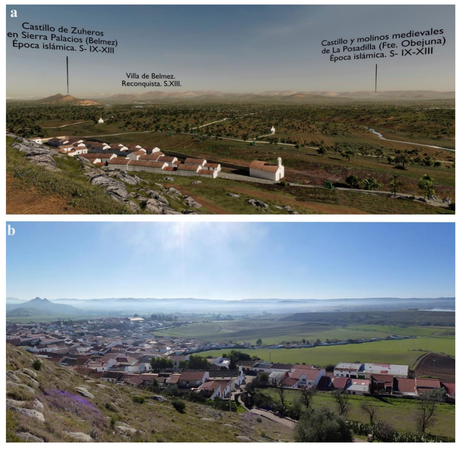
The other important development stage in this landscape corresponds to the medieval period, however for different reasons. During this period of abandonment and conflict, the industrial activity disappeared, land ceased to be cultivated at the same intensity, and defensive fortresses were built. Small towns, such as Belmez and Fuente Obejuna (which remain today), were founded and can still be seen from Belmez castle. This is the landscape that we wanted to narrate.
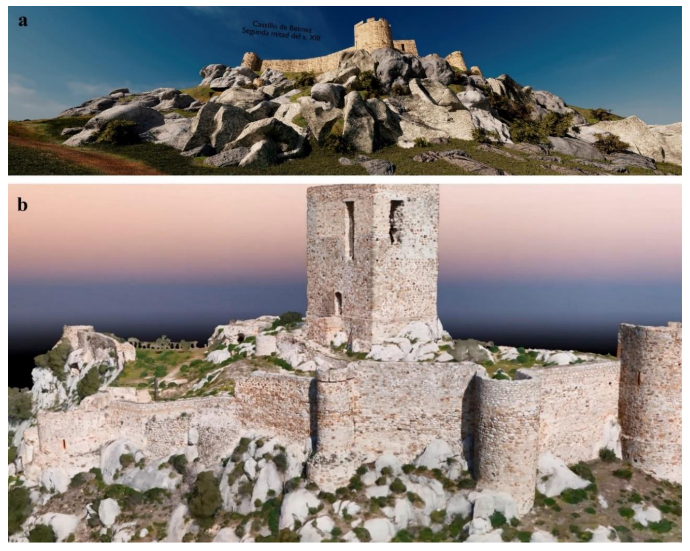
The large amount of data available for the CCB enabled us to develop the usual research, conservation, and dissemination tools. However, given that the information had an enormous visual and narrative potential, we decided to use immersive virtual reality technologies (
Figure 11,
Figure 12,
Figure 13 and
Figure 14).
There are many examples of the immersive virtualization of monuments, sites, and landscapes. Following the development of photogrammetry and 3D spatial capture techniques, immersive technology has become an increasingly common tool for experiencing heritage visually [
42].
Virtualization techniques have been used to investigate archeological sites, although usually only as partial views rather than complete landscapes [
43].
Likewise, 3D vision technologies have been used for the research and management of archeological landscapes [
44], and there are numerous examples of 3D reconstructions of monuments [
45], as well as experiences of inserting certain monuments into existing landscapes [
46].
However, experiences in the direct and full-scale recreation of historical landscapes are less common. To extend the findings of this project, we decided to create a virtual lookout of the historical landscape of the Alto Guadiato. This virtual lookout, which is called GudiatVR (
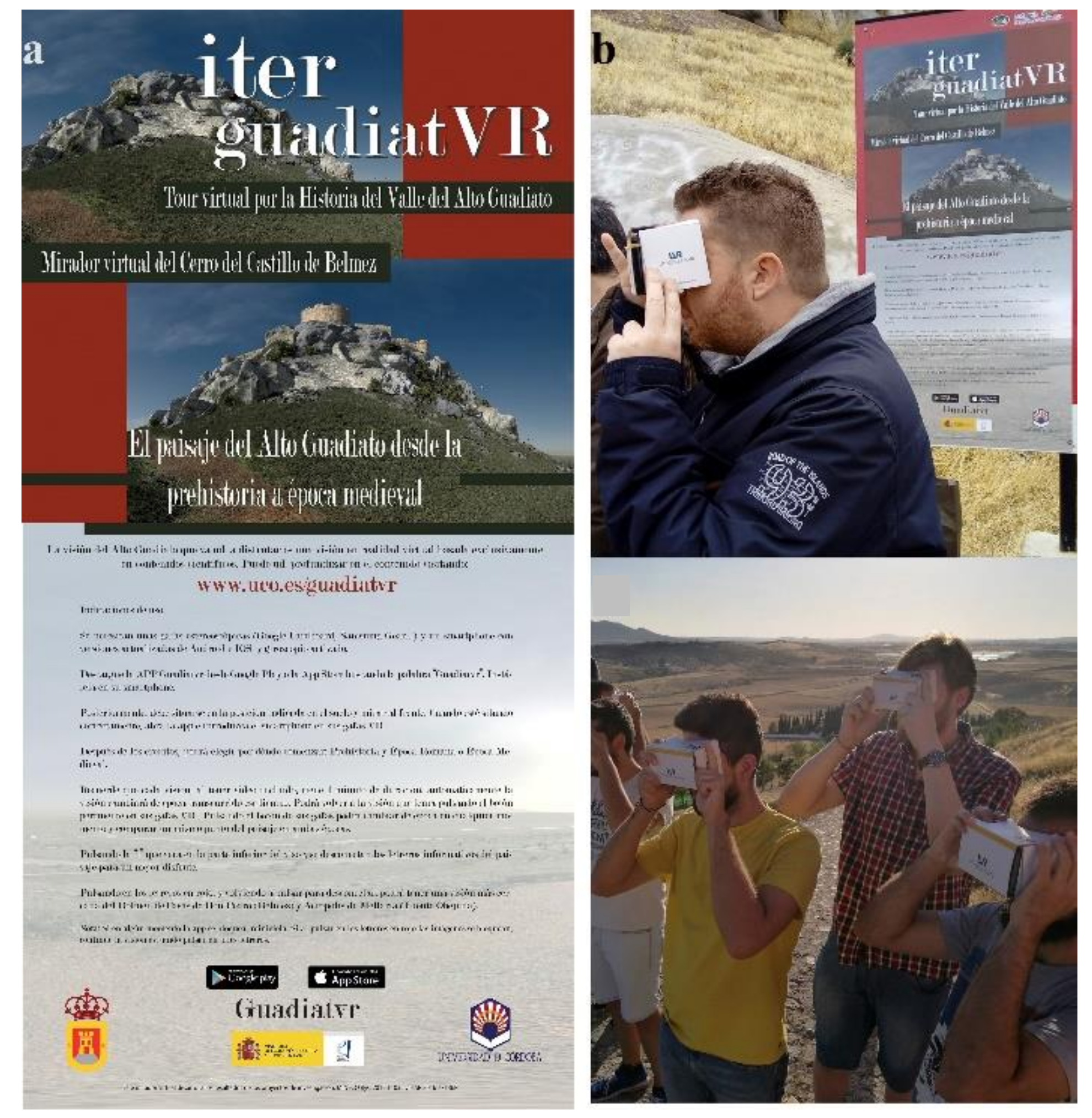
www.uco.es/guadiatvr), is not just another virtual recreation. We virtualized an entire landscape, including the air, sunset, incidence of light on the monuments, and other aspects, involving great technical difficulty.
In 2017, Lithodomos VR was commissioned by the University of Cordoba to recreate an in situ lookout for the Ager Mellariensis project using virtual reality. During the project, a number of research, 3D modeling, and application development methodologies were employed. The project was carried out over three broad phases: a definition phase, development phase, and delivery phase.
During the definition phase, researchers at Lithodomos assessed archeological reports, plans, publications, and 3D scans of the area provided by Dr. Monterroso-Checa. These were summarized into a project scope document, which contained digitized references and provided the necessary references for the 3D development team to create preliminary 3D models of the area. The primary software used to create these scenes was the open source application Blender. In addition, the scope document provided the foundation reference for the entire project, as well as all the elements used to build the 3D model. The scope document also recorded all “paradata” [
47]. This was to ensure that the process carefully documented how the data collected in previous phases of the project was used in the VR model, as well as all the choices that were made in creating the model. This document evolved over the next phase.
During the development phase, the team visited the site at Belmez. During this brief survey, GPS points were taken at the lookout and the surrounding area. The team visited the landmarks that would appear as “pop-up” windows during the experience. The team also took careful note of the surrounding landscape and its flora and fauna. By combing GPS data collected in situ, LiDAR scans of the area, and real-world scaling in Blender, a geolocated 3D model was created in distinct temporal phases and populated with digital assets created from reference drawings, photographs, and on-site observations. Draft 360° panoramic stereoscopic renderings of the phases of the site were then provided to Dr. Monterroso for review, and correction was carried out where necessary. The 2D “pop-up” images were also created as clickable landmarks from the lookout. Once the digital content had been signed off by Dr. Monterroso, the content was built into a Unity application and published in app stores [
48]. Additionally, this background was developed after thought as a web site [
49].
During the final delivery phase, some members of the team visited the site again to calibrate the application and to attend the soft launch of the project. Minor adjustments and corrections were made.
As a result of these methodologies, the digitization of traditional archeological reports, such as site plans, elevations, photographs, and field observations, was achieved. This resulted in a high-resolution 3D model of the area over three distinct phases, and in turn 360° panoramic, stereoscopic moving scenes. This data model represents the synthesis and presentation of previous archeological research in a way that a non-specialist visitor to the site can easily understand and enjoy.
5. Conclusions
To briefly conclude, this project has allowed us to recover and reconstruct a historical landscape in a novel and successful way through a combination of heritage sciences. At the local, regional, and national levels, we have developed a unique state-of-the-art tool for the protection, conservation, and promotion of heritage. The tool has been presented at prestigious research and transfer fairs in Spain, and also at one of the largest international tourism events in the world, the Fitur fair in Madrid. The GudiatVR app can be downloaded from IOS and Google Play (
Figure 15). People can enjoy an immersive experience in the very center of the CCB, where a “mirador virtual” or virtual lookout point was placed. More importantly, this virtual lookout brings the past to life, is accessible to all, is both scientific and attractive, and has served to heighten public interest in these archeological sites. We are currently working on these sites monographically, involving a strong social component.
Prior to this project, the local population of this area of northern Cordoba only looked back to its recent nineteenth century industrial mining past—its most immediate heritage. However, we now know that the origins of this area date to the Chalcolithic period and that it contains numerous Roman archeological remains, such as the road that once passed by the medieval castle that still stands in the town, and that the stone used for the castle had also been used in antiquity, long before medieval times.
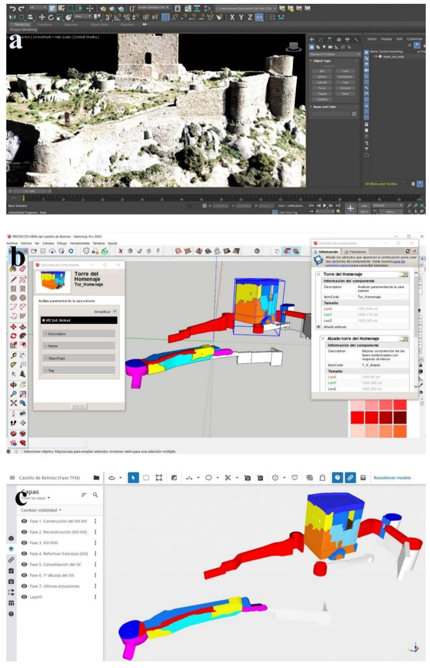
Additional results from this protocol are currently being developed. All the documentation acquired led to a clear conclusion—we must find new ways to protect and preserve the medieval castle of Belmez.
Therefore, all the photogrammetric acquisitions of the castle were modeled in SketchUp in the first step. In the second step, all the data and 3d acquisitions were managed in TrimbleConnect Building Investigation Modelling (BIM) software (
Figure 16).
These steps endowed the castle’s three-dimensional scientific documentation with a horizon of interoperability that did not previously exist, whereby volume calculations or specific measurements can be made automatically. Elements such as towers and stretches of wall were parameterized with the ”components” option, dividing the architectural spaces in order to provide an organized and specialized work experience for each conserved element. For future restoration interventions, the medieval castle of Belmez is at the BIM maturity level in accordance with the awarding of grants from the Spanish Ministry of Development.
We have told the story and preserved the castle and its surrounding environment through virtual and digital data files. Now, we “only” need to obtain the funding for the architectural restoration.

 ,
, 


