Cloud Computing Based on Computational Characteristics for Disaster Monitoring
Abstract
:1. Introduction
2. Related Work
2.1. Computing Technology of Remote-Sensing Scientific Processing
2.2. Cloud Computing for Remote-Sensing Data Analysis
3. Cloud Computing Model for Disaster Monitoring
3.1. Computational Characteristics and Classification of Disaster-Monitoring Models
- (1)
- Numerical Calculation
- (2)
- Iterative Calculation
- (3)
- Statistical Analysis
- (4)
- Neighborhood Operation
- (5)
- Frequency Domain Operation
3.2. Application of MapReduce for Disaster-Monitoring Model
- (1)
- Numerical Calculation
| Algorithm 1: The cloud computing model for Numerical Calculation |
|
- (2)
- Iterative Calculation
| Algorithm 2: The cloud computing model for Iterative Calculation |
|
- (3)
- Statistical Analysis
| Algorithm 3: The cloud computing model for Statistical Analysis |
|
- (4)
- Neighborhood Operation
| Algorithm 4: The cloud computing model for Neighborhood Operation |
|
- (5)
- Frequency Domain Operation
| Algorithm 5: The cloud computing model for Frequency Domain Operation |
|
4. Experiments and Performance Evaluation
4.1. Description of Computing Models for Use Cases in Cloud Environments
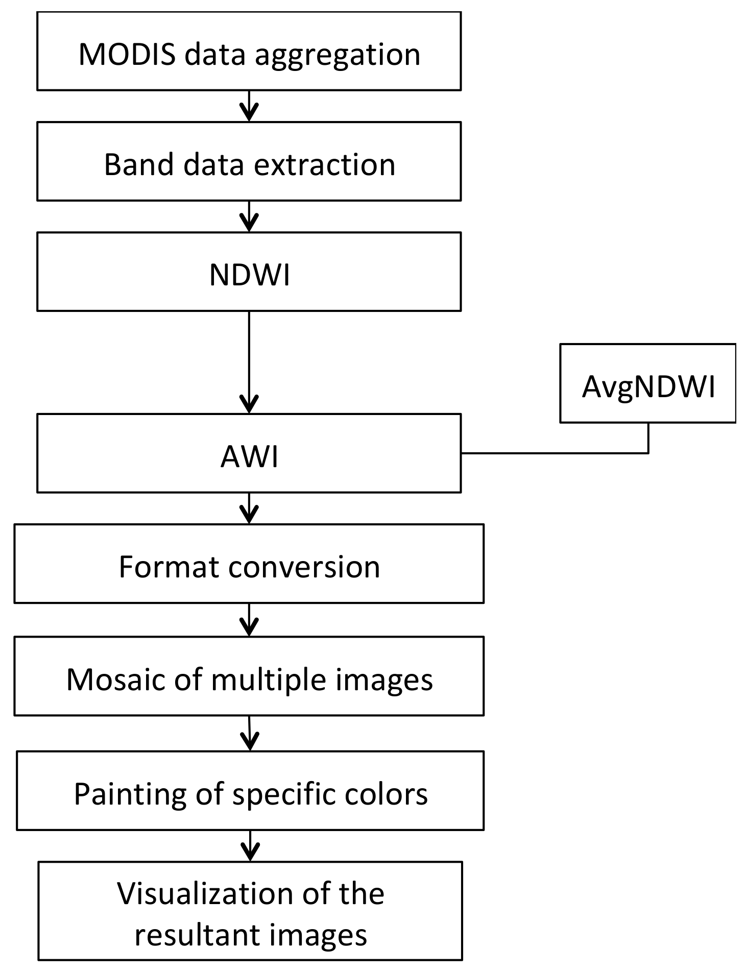
| Algorithm 6: The cloud computing model for anomaly water index (AWI) |
|
4.2. Performance Evaluation
5. Conclusions
Author Contributions
Funding
Conflicts of Interest
References
- Ma, J.; Sun, W.; Yang, G.; Zhang, D. Hydrological Analysis using Satellite Remote Sensing Big Data and CREST Model. IEEE Access 2018, 6, 9006–9016. [Google Scholar] [CrossRef]
- Jeansoulin, R. Review of Forty Years of Technological Changes in Geomatics toward the Big Data Paradigm. Int. J.Geo Inf. 2016, 5, 155. [Google Scholar] [CrossRef]
- Zhan, Q.; Yu, L. Segmentation of LiDAR Point Cloud Based on Similarity Measures in Multi- dimension Euclidean Space. Adv. Intell. Soft Comput. 2012, 141, 349–357. [Google Scholar]
- Zhang, L.; Zhang, L.; Tao, D.; Huang, X. A modified stochastic neighbor embedding for multi-feature dimension reduction of remote sensing images. ISPRS J. Photogramm. Remote Sens. 2013, 83, 30–39. [Google Scholar] [CrossRef]
- Yang, J.; Ma, Z.; Dang, J.; Wei, L.; Wang, Y. Improved fast-ica for change detection of multi temporal remote sensing images. In Proceedings of the 2018 IEEE 16th Intl Conf on Dependable, Autonomic and Secure Computing, 16th Intl Conf on Pervasive Intelligence and Computing, 4th Intl Conf on Big Data Intelligence and Computing and Cyber Science and Technology Congress(DASC/PiCom/DataCom/CyberSciTech), Athens, Greece, 12–15 August 2018; Volume 1, pp. 357–361. [Google Scholar]
- Zhang, W.; Lin, J.; Peng, J.; Lu, Q. Estimating Wenchuan Earthquake induced landslides based on remote sensing. Int. J. Remote Sens. 2010, 31, 3495–3508. [Google Scholar] [CrossRef]
- Tong, X.; Luo, X.; Liu, S.; Xie, H.; Chao, W.; Liu, S.; Jiang, Y. An approach for flood monitoring by the combined use of Landsat 8 optical imagery and COSMO-SkyMed radar imagery. ISPRS J. Photogramm. Remote Sens. 2018, 136, 144–153. [Google Scholar] [CrossRef]
- TralliT, D.M.; Blom, R.G.; Zlotnicki, V.; Donnellan, A.; Evan, D.L. Satellite remote sensing of earthquake, volcano, flood, landslide and coastal inundation hazards. ISPRS J. Photogramm. Remote Sens. 2005, 59, 185–198. [Google Scholar] [CrossRef]
- Ozelkan, E.; Chen, G.; Üstündaǧ, B. Multiscale object-based drought monitoring and comparison in rainfed and irrigated agriculture from Landsat 8 OLI imagery. Int. J. Appl. Earth Obs. Geoinf. 2016, 44, 159–170. [Google Scholar] [CrossRef]
- Ajaj, Q.; Pradhan, B.; Noori, A.; Jebur, M. Spatial monitoring of desertification extent in western Iraq using landsat images and gis. Land Degrad. Dev. 2017, 28, 2418–2431. [Google Scholar] [CrossRef]
- Cheng, T.; Li, D.; Wang, Q. On parallelizing universal Kriging interpolation based on OpenMP, Ninth International Symposium on Distributed Computing and Applications to Business. In Proceedings of the 2010 Ninth International Symposium on Distributed Computing and Applications to Business, Engineering and Science, Hong Kong, China, 10–12 August 2010. [Google Scholar]
- Maulik, U.; Sarkar, A. Efficient parallel algorithm for pixel classification in remote sensing imagery. Geoinformatica 2012, 16, 391–407. [Google Scholar] [CrossRef]
- Van Den Bergh, F.; Wessels, K.J.; Miteff, S.; Van Zyl, T.L.; Gazendam, A.D.; Bachoo, A. HiTempo: A platform for time-series analysis of remote-sensing satellite data in a high-performance computing environment. Int. J. Remote Sens. 2012, 33, 4720–4740. [Google Scholar] [CrossRef]
- Plaza, A.; Du, Q.; Chang, Y.; King, R.L. Foreword to the Special Issue on High Performance Computing in Earth Observation and Remote Sensing. IEEE J. Sel. Top. Appl. Earth Obs. Remote Sens. 2011, 4, 503–507. [Google Scholar] [CrossRef] [Green Version]
- Xue, Y.; Wan, W.; Ai, J. High Performance Geocomputation Developments. World SciTech R D 2008, 30, 314–319. [Google Scholar]
- Wang, P.; Wang, J.; Chen, Y.; Ni, G. Rapid processing of remote sensing images based on cloud computing. Future Gener. Comput. Syst. 2013, 29, 1963–1968. [Google Scholar] [CrossRef]
- Hu, F.; Yang, C.; Schnase, J.L.; Duffy, D.Q.; Xu, M.; Bowen, M.K.; Song, W. ClimateSpark: An in-memory distributed computing framework for big climate data analytics. Comput. Geosci. 2018, 115, 154–166. [Google Scholar] [CrossRef]
- Roy, S.; Gupta, S.; Omkar, S. Case study on: Scalability of preprocessing procedure of remote sensing in Hadoop. Comput. Sci. 2017, 108C, 1672–1681. [Google Scholar] [CrossRef]
- Zhao, Y.; Gao, J. Research on the Technological Architecture for Implementation of the Compute-intensive Spatial Information Services. Geospat. Inf. 2010, 5, 11–14. [Google Scholar]
- Xia, L.; Zhao, L.B.; Zhang, X.P.; Zhou, X.M. Study on the quality control methods of cluster-based remote sensing image processing. Int. Arch. Photogramm. Remote Sens. Spatial Inf. Sci. 2013, XL-2/W1, 31–34. [Google Scholar] [CrossRef] [Green Version]
- Li, G.; Liu, D. Key Technologies Research on Building a Cluster-based Parallel Computing System for Remote Sensing. LNCS 2005, 3516, 484–490. [Google Scholar]
- Kussul, N.N.; Shelestov, A.Y.; Skakun, S.V.; Li, G.; Kussul, O.M. The Wide Area Grid Testbed for Flood Monitoring Using Earth Observation Data. IEEE J. Sel. Top. Appl. Earth Obs. Remote Sens. 2012, 5, 1746–1751. [Google Scholar] [CrossRef]
- Zeng, Y.; Li, G.; Guo, L.; Huang, H. An On-Demand Approach to Build Reusable, Fast-Responding Spatial Data Services. IEEE J. Sel. Top. Appl. Earth Obs. Remote Sens. 2012, 5, 1665–1677. [Google Scholar] [CrossRef]
- Fustes, D.; Cantorna, D.; Dafonte, C.; Arcay, B.; Iglesias, A.; Manteiga, M. A cloud-integrated web platform for marine monitoring using GIS and remote sensing: Application to oil spill detection through SAR images. Future Gener. Comput. Syst. 2014, 34, 155–160. [Google Scholar] [CrossRef]
- Perez, J.F.; Swain, N.R.; Dolder, H.G.; Christensen, S.D.; Snow, A.D.; Nelson, E.J.; Jones, N.L. From global to local: Providing actionable flood forecast information in a cloud-based computing environment. J. Am. Water Resour. Assoc. 2016, 52, 965–978. [Google Scholar] [CrossRef]
- Wang, L.; Ma, Y.; Yan, J.; Chang, V.; Zomaya, A.Y. PipsCloud: High performance cloud computing for remote sensing big data management and processing. Future Gener. Comput. Syst. 2018, 78, 353–368. [Google Scholar] [CrossRef] [Green Version]
- Lu, W.; Wang, Y.; Jiang, J.; Liu, J.; Shen, Y.; Wei, B. Hybrid storage architecture and efficient MapReduce processing for unstructured data. Parallel Comput. 2017, 69, 63–77. [Google Scholar] [CrossRef]
- Luo, C.; He, F.; Ghezzi, C. Inferring software behavioral models with MapReduce. Sci. Comput. Program. 2017, 145, 13–36. [Google Scholar] [CrossRef]
- Zeng, X.; Garg, S.K.; Wen, Z.; Strazdins, P.; Zomaya, A.Y.; Ranjan, R. Cost efficient scheduling of MapReduce applications on public clouds. J. Comput. Sci. 2018, 26, 375–388. [Google Scholar] [CrossRef] [Green Version]
- Wang, W.; Ying, L. Data locality in MapReduce: A network perspective. Perform. Eval. 2016, 96, 1–11. [Google Scholar] [CrossRef] [Green Version]
- Lua, W.; Chen, L.; Wang, L.; Yuan, H.; Xing, W.; Yang, Y. NPIY: A novel partitioner for improving mapreduce performance. J. Vis. Lang. Comput. 2018, 46, 1–11. [Google Scholar] [CrossRef]
- Selvitopi, O.; Demirci, G.V.; Turk, A.; Aykanat, C. Locality-aware and load-balanced static task scheduling for MapReduce. Future Gener. Comput. Syst. 2019, 90, 49–61. [Google Scholar] [CrossRef] [Green Version]
- Gouasmi, T.; Louati, W.; Kacem, A.H. Exact and heuristic MapReduce scheduling algorithms for cloud federation. Comput. Electr. Eng. 2018, 69, 274–286. [Google Scholar] [CrossRef]
- Zou, Q.; Li, Q.; Yu, W. MapReduce functions to remote sensing distributed data processing—Global vegetation drought monitoring as example. Softw. Pract. Exp. 2018, 48, 1352–1367. [Google Scholar] [CrossRef]
- Li, Z.; Huang, Q.; Carbone, G.J.; Hu, F. A high performance query analytical framework for supporting data-intensive climate studies. Comput. Environ. Urban Syst. 2017, 62, 210–221. [Google Scholar] [CrossRef]
- Yao, X.; Mokbel, M.F.; Alarabi, L.; Eldawy, A.; Yang, J.; Yun, W.; Zhu, D. Spatial coding-based approach for partitioning big spatial data in Hadoop. Comput. Geosci. 2017, 106, 60–67. [Google Scholar] [CrossRef] [Green Version]
- Jing, W.; Tian, D. An improved distributed storage and query for remote sensing data. Procedia Comput. Sci. 2018, 129, 238–247. [Google Scholar] [CrossRef]
- Mazhar, M.; Rathore, U.; Ahmad, A.; Paul, A.; Wu, J. Real-time continuous feature extraction in large size satellite images. J. Syst. Archit. 2016, 64, 122–132. [Google Scholar]
- Li, X.; Song, J.; Zhang, F.; Ouyang, X.; Khan, S.U. MapReduce-based fast fuzzy c-means algorithm for large-scale underwater image segmentation. Future Gener. Comput. Syst. 2016, 65, 90–101. [Google Scholar] [CrossRef]
- Sharma, N.; Bagga, S.; Girdhar, A. Novel approach for denoising using hadoop image processing interface. Procedia Comput. Sci. 2018, 132, 1327–1350. [Google Scholar] [CrossRef]
- Xia, H.; Karimi, H.A.; Meng, L. Parallel implementation of Kaufman’s initialization for clustering large remote sensing images on clouds. Comput. Environ. Urban Syst. 2017, 61, 153–162. [Google Scholar] [CrossRef]
- Wiki Site. Available online: https://en.wikipedia.org/wiki/Neighborhood_operation (accessed on 1 January 2020).
- Bai, L.; Yan, Q.; Zhang, L. Sensitivity analysis of response of MODIS derived drought indices to drought in North China. Arid Land Geogr. 2012, 35, 708–716. [Google Scholar]
- Sai, W.; Qiuwen, Z. Method and model of water body extraction based on remote sensing data of MODIS. Comput. Digit. Eng. 2005, 33, 1–4. [Google Scholar]
- Skakun, S. A neural network approach to flood mapping using satellite imagery. Comput. Inform. 2010, 29, 1013–1024. [Google Scholar]
- Tang, J.; Xue, Y.; Yu, T.; Guan, Y. Aerosol optical thickness determination by exploiting the synergy of TERRA and AQUA MODIS. Remote Sens. Environ. 2005, 94, 327–334. [Google Scholar] [CrossRef]


| Typical Disaster-Monitoring Models | Model Description | Algorithm Involved | Computational Complexity |
|---|---|---|---|
| Vegetation drought monitoring model | It was established based on the anomaly water index (AWI model) [43]. | Band data extraction NDWI AWI AvgNDWI Mosaic Colorization Visualization Format conversion | Simple, O(n) |
| MODIS flood-monitoring model | Water information extracted from optical images of MODIS data using NDVI (normalized difference vegetation index) [44]. | Mosaic Image segmentation Geometric correction Calibration correction NDVI Colorization Visualization Format conversion | Simple, O(n) |
| SAR Flood monitoring model | A neural network method for synthetic aperture radar (SAR) image segmentation and classification has been developed [45] to study flood extent extraction. | Mosaic Image segmentation Geometric correction Calibration correction Neural network classification Colorization Visualization Format conversion | Moderately complex, O(n2) |
| Aerosol optical thickness (AOT) inversion model | It implemented the collaborative inversion by using SYNTAM [46] algorithm. | Geometric correction Calibration correction Mosaic Colorization Visualization Image segmentation AOT | Complex, O(rn2), r is the number of iterations |
| Dust storm monitoring model | Extract dust information and the results will be used as mask for dust classify with brightness temperature differences. | Geometric correction Calibration correction Dust extract Bright temperature Dust intensity Dust classify Mosaic Colorization Visualization | Moderately complex, O(n2) |
| Number | Algorithm Type | Algorithm Name |
|---|---|---|
| 1 | Numerical calculation | NDWI, AWI, AvgNDWI, NDVI, Calibration correction, Dust extraction, Brightness temperature, Dust intensity, Colorization, Band data extraction |
| 2 | Iterative calculation | AOT |
| 3 | Statistical analysis | AvgNDWI, Dust classification, Image segmentation |
| 4 | Neighborhood operation | Mosaic, Colorization, Visualization, Format conversion, Geometric correction, Image segmentation, Neural network classification |
| 5 | Frequency domain operation | FFT |
| Models | Programs (with MR) | Programs (without MR) |
|---|---|---|
| Vegetable drought monitoring model | 156 | 782 |
| Dust storm monitoring model | 324 | 2754 |
| AOT inversion model | 219 | 2373 |
© 2020 by the authors. Licensee MDPI, Basel, Switzerland. This article is an open access article distributed under the terms and conditions of the Creative Commons Attribution (CC BY) license (http://creativecommons.org/licenses/by/4.0/).
Share and Cite
Zou, Q.; Li, G.; Yu, W. Cloud Computing Based on Computational Characteristics for Disaster Monitoring. Appl. Sci. 2020, 10, 6676. https://doi.org/10.3390/app10196676
Zou Q, Li G, Yu W. Cloud Computing Based on Computational Characteristics for Disaster Monitoring. Applied Sciences. 2020; 10(19):6676. https://doi.org/10.3390/app10196676
Chicago/Turabian StyleZou, Quan, Guoqing Li, and Wenyang Yu. 2020. "Cloud Computing Based on Computational Characteristics for Disaster Monitoring" Applied Sciences 10, no. 19: 6676. https://doi.org/10.3390/app10196676
APA StyleZou, Q., Li, G., & Yu, W. (2020). Cloud Computing Based on Computational Characteristics for Disaster Monitoring. Applied Sciences, 10(19), 6676. https://doi.org/10.3390/app10196676


