1. Introduction
Smouldering fires can be defined as slow, low-temperature, flameless combustions, involving both endothermic and exothermic reactions, that propagate via porous materials in a three dimensional fashion [
1]. This combustion is the most persistent combustion phenomena known [
2,
3] and generate the longest and largest fire episodes on Earth, usually occurring in peat and coal deposits in tropical and boreal zones [
4]. Smouldering combustion occurs when heat is released and oxygen directly attacks the surface of the solid fuel [
2]. The phenomenon is common in porous fuels that form char on heating, for example on wood, duff and peat [
5]. The ignition and propagation of smouldering fires in the duff layer depend basically on two physicochemical properties: moisture and inorganic mineral contents [
6]. The most important property, however, is the moisture content [
7]. In boreal peatlands, the humidity threshold (defined as the 50% probability of ignition/extinction) for a peat sample lies between 110% and 250% moisture, on a dry weight basis [
7,
8,
9,
10]. The second most important property is mineral content, the extinction/non-ignition threshold in peatlands being 81.5% [
7]. There is a direct and negative relationship between mineral content and moisture determining the ignition threshold of organic matter, since if a sample with a high moisture percentage burns, it means that the mineral content is very low, and vice versa [
7]. Lateral spread is more pronounced on shallower surfaces (<2 m), since the oxygen supply is greater [
4]. This spread forms a smoldering front which presents a structure composed of four subfronts: those of pre-heating, drying, pyrolysis and oxidation [
3]. For most smoldering materials under natural conditions, the two mechanisms that control the rate of spread are the oxygen supply and the heat transfer [
2]. At the micro scale, smoldering takes place on the surface of the pores of a solid fuel, while at the macro scale, it is a bulk phenomenon affecting the fuel bed. With depth inside the fuel bed, the loss of oxygen and heat transfer slows down the spread rate. Depending on the fuel bed characteristics and the wind conditions, there are minimum and maximum depths between which smoldering can spread [
3]. The concept of optimal depth has yet to be sufficiently studied and could vary widely for different systems on a scale of centimeters to meters [
3]. It should be stressed that the spatial heterogeneity in soil moisture content plays a very important role in the variability of smoldering spread [
9].
One of the potential causes of smouldering fires is the progressive abandonment of forest management practices in Mediterranean forests. This tendency has occurred for the last 60 years in several Mediterranean regions [
11]. The consequence is the increase of understory biomass and, consequently, the increase of dead fuel available and its combustibility, both in flammable and smouldering forms. With time, the accumulation of organic matter in partial decay in flat and humid areas, contributes to increase the depth of uppermost layers with organic soils in a range of decomposition stages. In the case of Mediterranean areas due to the thermal regime is hot in summer and cold in winter, with an average temperature of 12–14 °C and a thermal oscillation of 17–21 °C; with an average rainfall is 350–550 mm; and a period of drought that oscillates between June and August and the frost-free period extends between May and September, both included [
12] due to these specific conditions and global change these areas are changing constantly and that it is necessary to understand how these changes affect the soil conditions and combustion characteristics of the forest.
An emergence of different environmental conditions in Mediterranean climates is expected as: an increasing temperature trends and longer periods of drought in the Mediterranean [
13,
14], the consequent increase in water stress [
15,
16] and the accumulation of forest floor fuels [
17]. These changes could affect the fire regimes by increasing the dry, decomposed fuel accumulation leading to a larger number of smouldering fires and re-ignitions. At the local level, the annual temperature trend (1950–2015) in the study area is + 0.24 °C/decade, winter + 0.17 °C/decade, spring + 0.25 °C/decade, summer + 0.35 °C/decade and autumn + 0.19 °C/decade. The indicator of duration of the warm spell (IDWS) and the indicator of duration of the season of growth (IDSG) present a statistically significant positive trend, with an increase of 2.9 days/decade [
18]. These changes in temperature extremes in the two seasons when the risk of fires is highest (spring and summer) may, in the future, result in an increase in the number of fires and changes in the fire regime [
19]. The increase in drought conditions and the water deficit in spring and summer are likely to cause greater risks of forest fires [
19]. According to forecasts made by Barrera–Escoda et al. [
20] and Gonçalves et al. [
21] and described by Calbó et al. [
14] for the Mediterranean-continental climate zone, the mean annual temperature will increase by + 0.7 [+ 0.5 / + 1] °C in 2021. This increase would be greater in summer (+ 0.9 [+ 0.5 / + 1.5] °C) than in the other seasons. Annual precipitation would vary significantly, with a possible increase of + 0.7 [− 14.1 / + 8] %, but it could vary seasonally, with an increase in winter, but with losses in the other seasons of the year. All these projected changes would have a major impact on the already scarce water resources of the zone.
The duff’s bulk density, porosity and organic composition are other important properties that have a direct impact on the ignition and propagation of smouldering fires [
4]. The bulk density directly influences the fire ignition and extinction properties of organic matter, the critical moisture for extinction is higher than the critical moisture for ignition [
22]. In addition, the bulk density influences the depth of combustion and the critical moisture threshold for extinction, since it regulates the oxygen supply, permeability and thermal inertia [
22,
23]. The use of models that analysed combustion characteristics have been used in different ecosystems but in few cases for the Mediterranean ecosystem [
1,
3,
7,
9]. Soil characteristics and its changes and effects in these combustion characteristics have been analysed inn various manuscripts [
6,
8,
22,
23] but in any of them the soil analysed properties are in none of them was the number of soil variables analysed so high, giving this study a very high value and representativeness.
In the Mediterranean region, smouldering combustion has been little studied as in general the region’s soils have low levels of organic matter accumulation. However, in the Mediterranean soils that do accumulate organic layers, the relevant impacts of smouldering include the break-out of new flaming fires, the release of carbon from the soil into the atmosphere and the release of C stored in the soil’s organic matter [
7].
The particular case study of the Rocallaura Fires, also bring to light the need to bridge the gap between science and management. During the fire season in the Mediterranean region, the emergency response system is highly stress attending the several fires that break out continuously. Every fire emergency needs to be dealt efficiently with the minimum resources and time, especially if there is risk of simultaneous fire events that could stress the system even more [
24]. The fact, that the Rocallaura fires had organic soils smouldering, required extra efforts from the Catalan Fire and Rescue Service forest fire units to control the smouldering fire that finally reignited a flammable fire jeopardising the organisation’s efficiency and finally impacting on population at risk. Better understanding the behaviour of smouldering fires in Mediterranean organic soils, contributes towards better informed science-based decisions in fire management. For the reasons described the smouldering combustion of soils in Mediterranean environments require further study.
The aim of this study is to better understand the conditions under which smouldering combustion propagates in organic soils in Mediterranean-type ecosystems. To achieve this goal, first, the properties of the soils that sustain smouldering combustion in the area were analysed, this included the organic content, inorganic content, bulk density, moisture of the duff layer. Second, the fire impact on soil and third its combustion characteristics (ignition, consumption and subsequent propagation) using models designed in various studies and applying them to the specific case of a Mediterranean forest.
2. Material and Methods
2.1. Study Area and Fire History
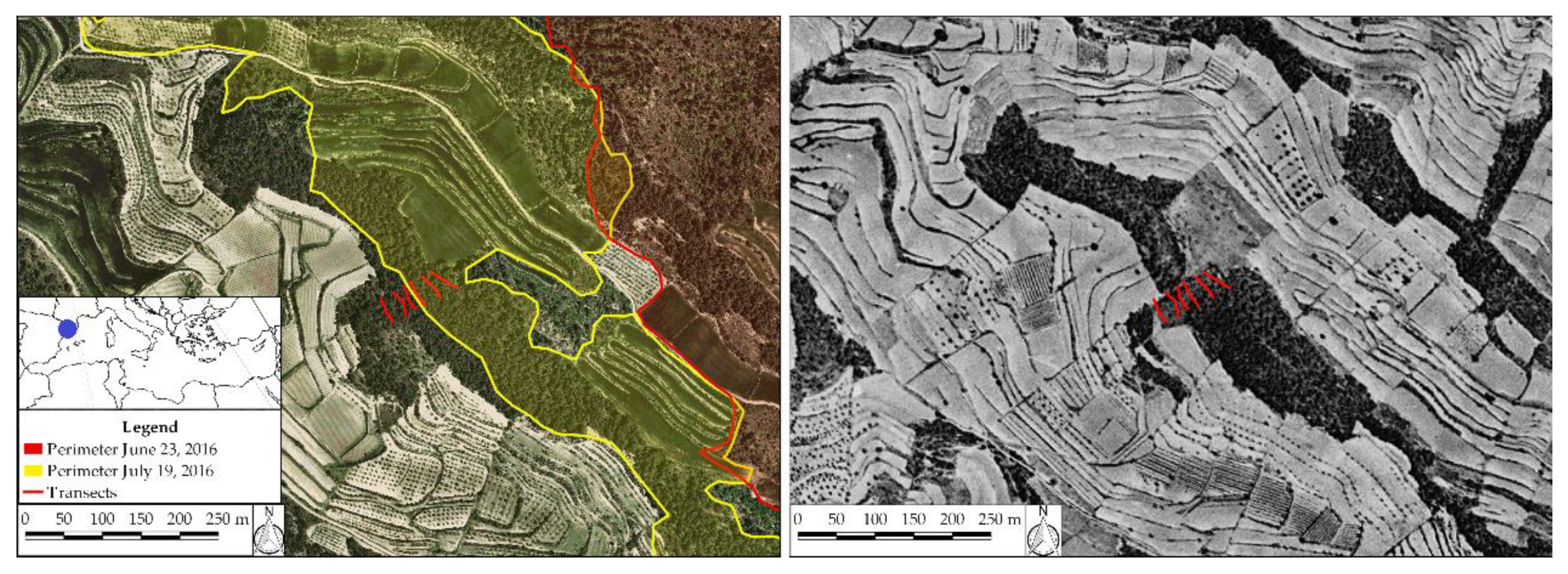
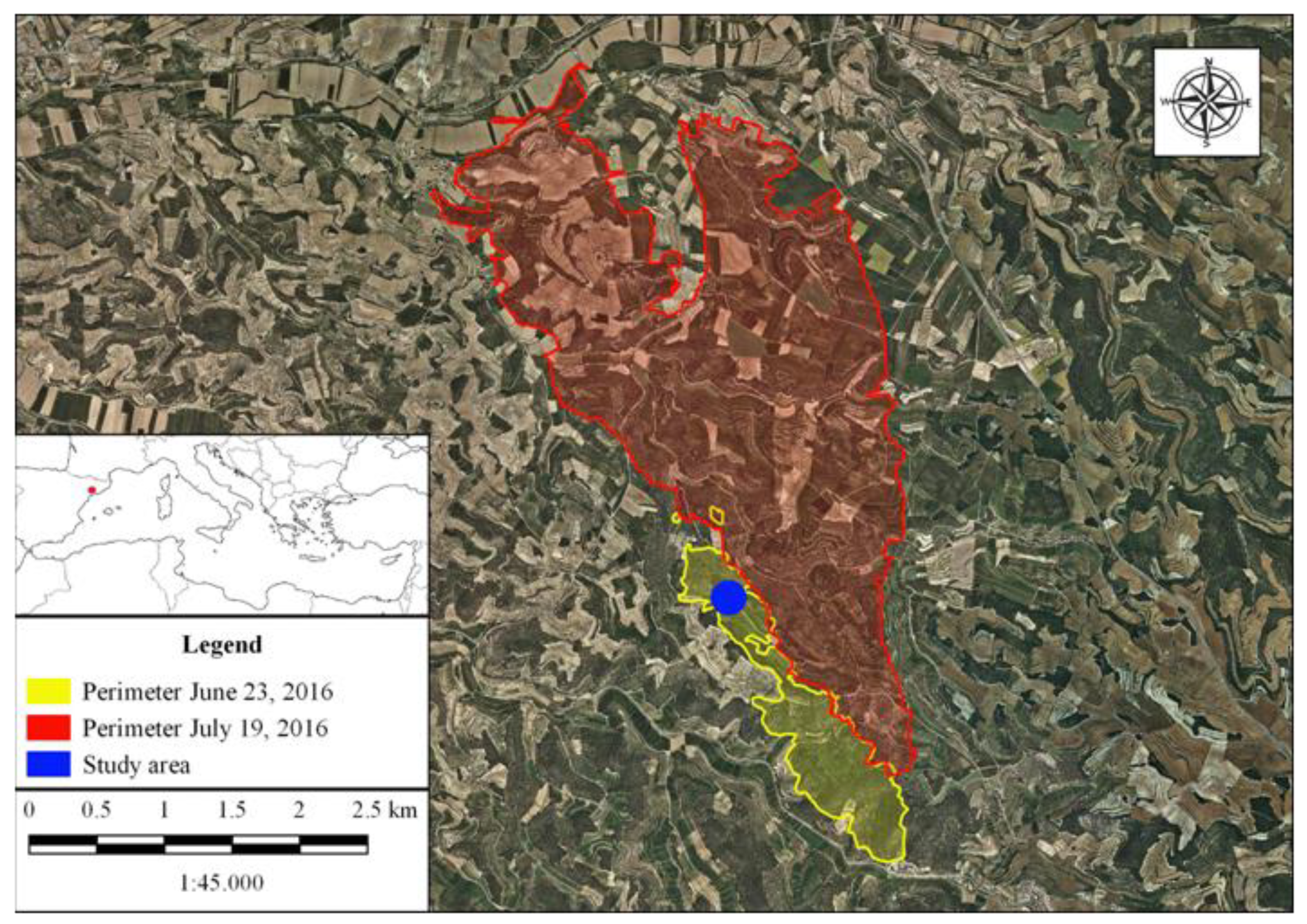
The study area lies in the Serra de Senadelles, between the villages of Rocallaura (municipality of Vallbona de les Monges) and Nàlec, Lleida (41°31′28.0″ N 1°07′12.1″ E, 615 m a.s.l.) in the Northeast of the Iberian Peninsula (
Figure 1).
The study area’s forest is composed of a dominant tree stratum of
Pinus halepensis Mill (42 aa CORINE) [
25]. The shrub stratum consists mainly of
Phillyrea latifolia,
Quercus coccifera,
Pistacia lentiscus,
Quercus ilex,
Erica multiflora and
Rosmarinus officinalis. The herbaceous stratum is dominated by several species of moss,
Brachypodium retusum and some individuals of the
Orchidaceae family (
Figure 2). The area has a normalized difference vegetation index (NDVI) of between 0.2 and 0.4 [
26]. The
Pinus halepensis reaches an average height of 7 m to 11 m with a typical diameter at breast height of between 15 cm and 20 cm and a basal area of 20 m
2/ha to 30 m
2/ha. Leaf biomass oscillates between 3 and 5 t/ha, and total biomass between 60 t/ha and 120 t/ha [
27].
The trees have a maximum age of between 70 and 80 years and have not, in fact, been cut or burned since the Spanish civil war (1936–39). A line of trenches dug in the area during the conflict, and the associated risk of explosion of ancient artefacts, explains why the forests have been exposed to little management activity since the late 1930s. This fact, combined with rural abandonment, has resulted in the growth of moss and an increase in forest floor duff in zones with little slope.
The geological substrate is formed by Cenozoic sedimentary deposits. The lower part of the substrate contains marls with calcareous intercalations (Rupelian-Chattian); the middle contains shales, sandstones and calcareous forms (Rupelian-Chattian); and, the upper part contains clays, silts and fine-grained sandstones with intercalations of conglomerates (Rupelian) [
30]. Soils are classified as
Haploxeroll lithic [
31] and the characteristics have been specified in
Table 1.
On 23 June 2016, the first fire broke out affecting 103 ha of forest and agricultural land near the village of Rocallaura (Vallbona de les Monges, l’Urgell) (
Figure 3). On 25–29 June, various re-ignitions were recorded by the firefighting crews in different areas of the burned zone. On 4, 7 and 10 July, re-ignitions were registered in the forest floor and on tree trunks and stumps that continued to sustain smoldering combustion. No rain occurred during the period. On 18 July another re-ignition was registered burning 500 m
2. On 19 July the second fire broke out affecting a total area of 790 ha of forest and cultivated fields and threaten the Wildland Urban Interface in a day with simultaneous fire events. The re-ignition of the same area was attributable to the smouldering combustion that persisted in the areas where the previous fire was suppressed.
2.2. Experimental Design and Field Work
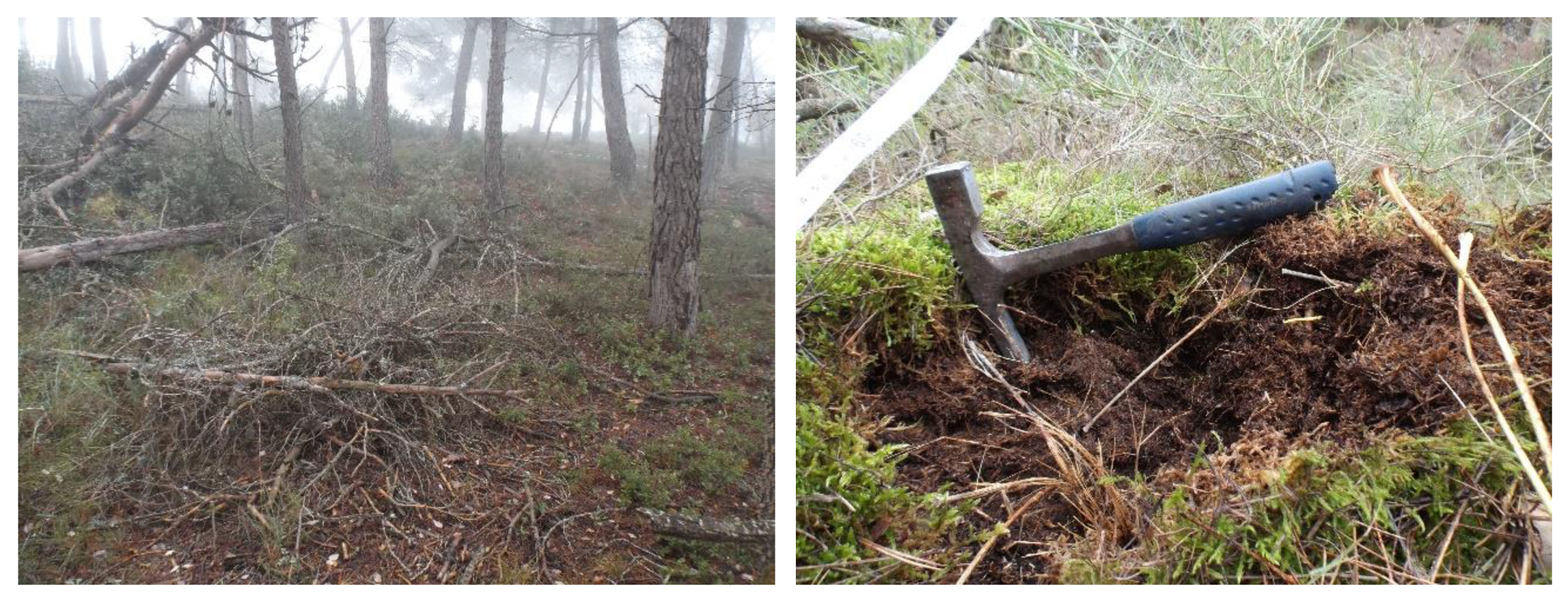
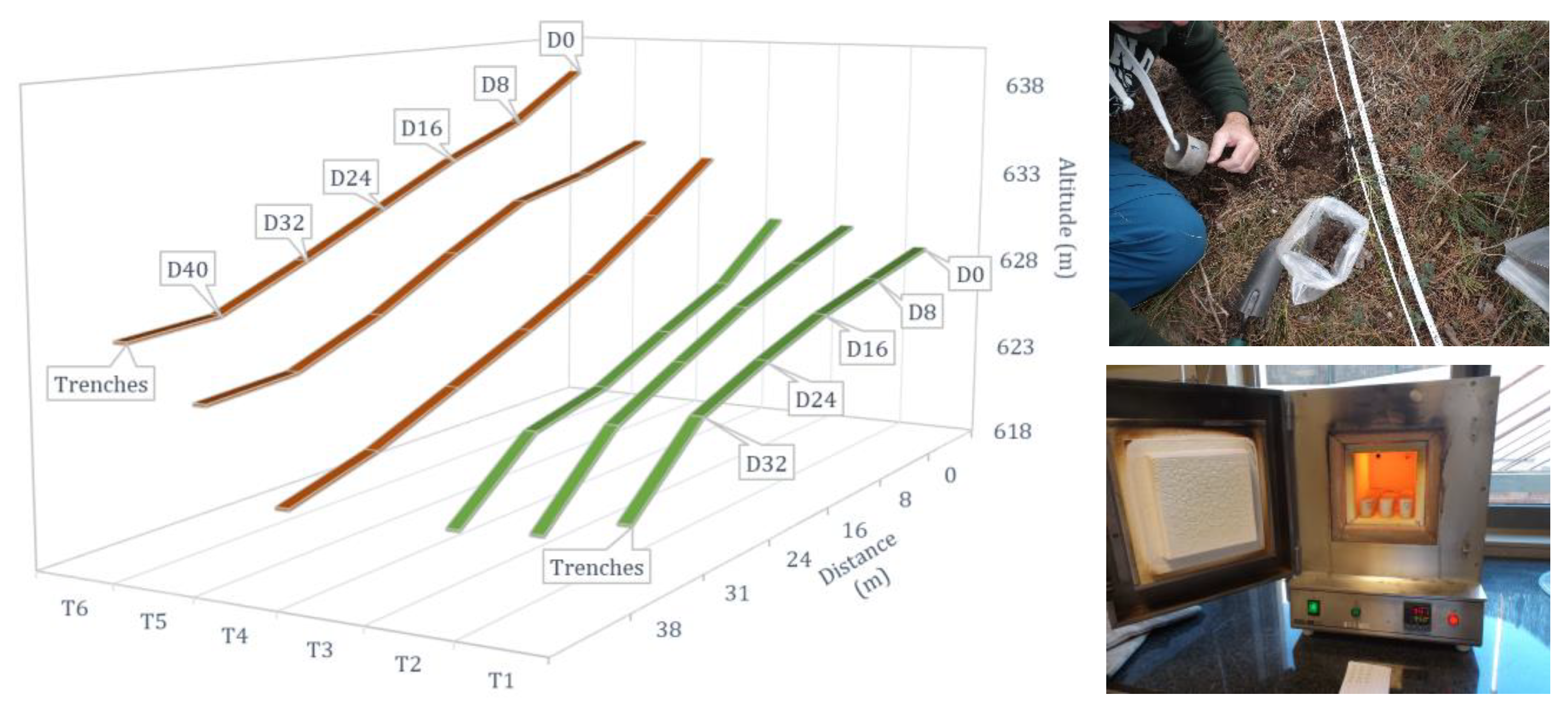
Three months and twelve days after the second fire (4 November 2016), six 40 m long transects were designed following the direction of maximum slope in order to cover a range of variability in the area, from which a total of 66 samples were taken (
Figure 4). Three transects were located in the burned zone, classified as having been subject to a low-intensity fire [
32], and the other three in a control zone contiguous to the burned area and with similar characteristics. The area was selected for showing evidences of being an area prone to smoldering combustion of soils. After indication from the Catalan Fire and Rescue Services in charge of the fire suppression operations, the area designated for sampling was identified as being the source of the second fire, an area where the several smoke plumes originated by the combustion of organic soil layers were detected repeatedly in the time between both flaming fire events.
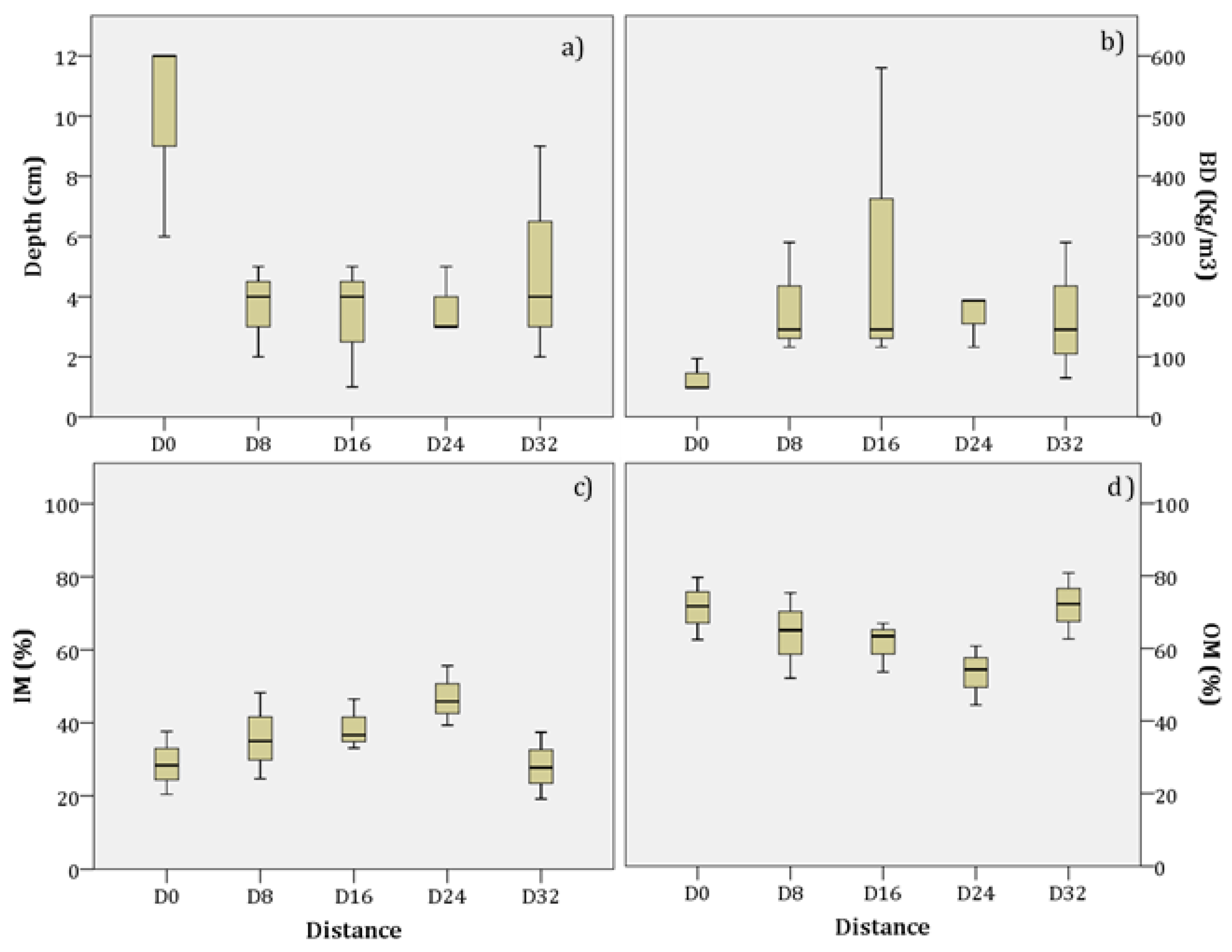
Soil samples were taken every eight meters (five samples per transect in the control zone and six per transect in the burned zone) of approximately 0.4 kg. In the control zone (C), three types of sample were taken according to their depth: organic layer or duff (excluding leaf litter) and soil layers between 0 cm to 5 cm and between 5 cm to 10 cm. In the burned area (F), because the duff had partially burned, samples could not be obtained from all the points and were limited to two specific depths (0–5 cm and 5–10 cm). D0 of the burned area are close to the zones were the smouldering combustion of soils took place. Then the number of total soil samples were 66, 30 from control zone and 36 from fire affected area. Duff samples were only collected in control area being a total of 15 samples.
2.3. Laboratory Analysis
Laboratory analysis were carried to determinate the physical and chemical properties on mineral and duff
(Oe + Oa) (bulk density, inorganic and organic carbon, organic matter and inorganic matter). Soil organic carbon, inorganic carbon, organic matter and inorganic matter were measured using the loss-on-ignition (LOI) method [
33,
34]. Mineral soil bulk density was analysed using the Périé and Ouimet [
35] empirical model and organic bulk density was analysed using Federer et al. [
36] model.
For the analysis of organic matter, the 3 variables C inorganic, C organic, and carbonates, work with a pulverized sample. A total of 1 g of dry sample at 60 °C is placed in a high temperature resistant glass. Subsequently, the samples are placed in the oven for 12 h at 105 °C in order to completely remove the humidity from the samples. The samples are allowed to cool in a hood for about 30 min and weighed again. Once all this is done, heat the muffle oven to 550 °C and place the samples for 4 h. After these four hours the samples are removed from the muffle, and they are again allowed to cool in a hood for approximately 30 min and are weighed. To conclude, the muffle is heated to 950 °C and the samples are placed again for 2 h. Finally, the samples are removed from the muffle and allowed to cool in a hood for 1 h to 2 h and they are weighed for the last time. Bulk density was calculated based on measured soil mass and soil volume exclusive of the >2-mm coarse fragments. The Federer model followed the theoretical relationship Db = DbmDbo/[FoDbm + (1−Fo) Dbo] where Db is the bulk density (Mg/m3), Fo is the organic fraction (kgo/kg), Dbo is the bulk density when Fo = 1, and Dbm is the bulk density when Fo = 0. The relation arises from assuming that (i) Dbo, the bulk density of “pure” organic matter, and Dbm, the bulk density of “pure” mineral matter, are constant and (ii) in a mixture, the volumes occupied by the organic mass and the mineral mass are additive. When these parameters are known, Db can be estimated from Fo, which is more easily measured. When Fo is greater than 0.1 kgo/kg, the organic mass per unit soil volume (FoDb), or organic density, is approximately constant at 0.1 Mgo/m3.
2.4. Statistical Analysis
Data normality and homogeneity of variances were tested using the Shapiro–Wilk and the Levène tests. For those variables in mineral soil samples that satisfied assumptions of normality and heteroscedasticity, statistical comparisons were conducted using the parametric t-Student. For those variables in mineral soil samples that satisfied only normality or homogeneity, the non-parametric U-Mann–Whitney was used.
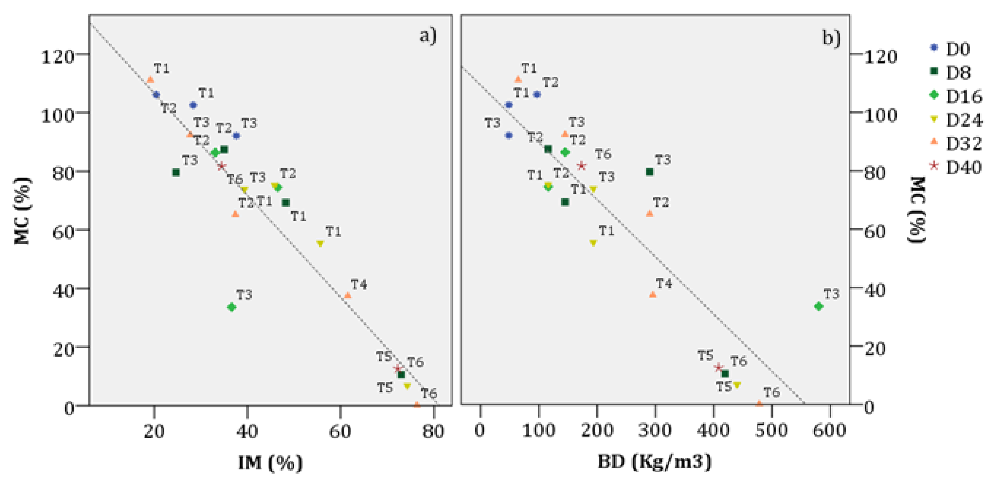
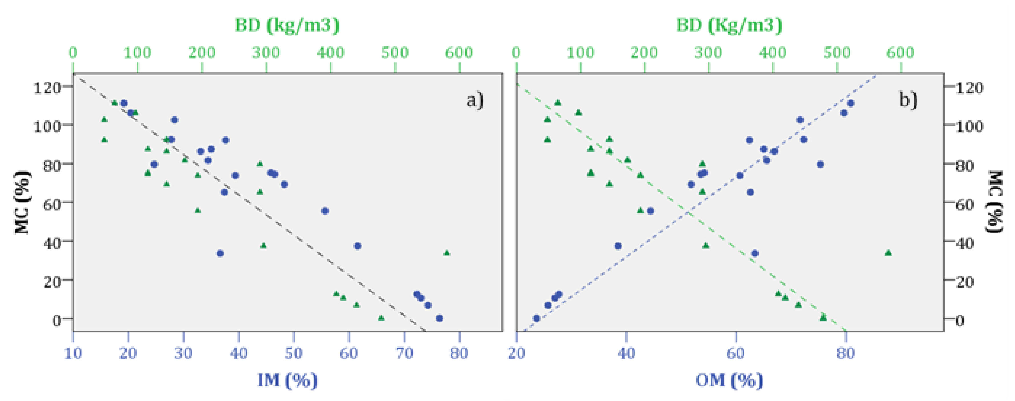
Smoldering combustion properties of control zone duff samples (N = 15) were estimated using three empirical models [
8,
9,
23], based on soil-property similarities (
Table 2). Duff ignition probability was estimated using the empirical model described in Frandsen [
8]; percentage fuel consumption was estimated using the Garlough and Keyes [
23] model and spread rate propagation was estimated using the Prat-Guitart et al. [
9] empirical model. Statistical software IBM SPSS Statistics v. 23 (IBM Corp. Released, 2015) was used for data analysis.
2.5. Probability of Smoldering Fire Ignition in Organic Soils
The probabilistic method was designed by Frandsen [
8]. This method relates the probability of ignition with the content of inorganic matter, the bulk density and the moisture content of the sample Equation (1):
where
B0,
B1,
B2 and
B3 are coefficients that vary according to the probabilistic distribution of each sample group.
H is the moisture content, in %,
IM is the mineral content, in %, and
BD is the bulk density kg/m
−3. The calculation of the moisture content was done at a probability of ignition of 50% (P
50) for each sample. Then, the result is expressed as the maximum moisture content given for ignition to occur. Isolating the percentage of maximum moisture content at a probability of 50% results in Equation (2):
Given the lack of tools to experimentally analyze ignition on the samples collected, the probability coefficients used (
B0,
B1,
B2 and
B3) are Frandsen [
8] for the sample group ‘
Pine duff (Seney)’ (
Table 3). This sample group have similar mean values of inorganic matter (IM, 36.5 ± 16%), organic matter (OM, 63.5 ± 16%) and bulk density (BD, 190 ± 19 kg/m
−3) at a 5 cm depth as the samples collected in Rocallaura (
Table 2).
2.6. Experimental Design to Examine the Effect of Soil Moisture and Bulk Density on the Smoldering Spread Rate
The spread rate of samples that could smolder is estimated using the linear regression model proposed by Prat-Guitart et al. [
9] (Equation (3)). This model estimates the spread rate in relation to the moisture content and bulk density by experimental analysis of commercial peat smoldering ignition at different bulk densities. The samples used in Prat-Guitart et al. [
9] had a depth of 6 cm, an average mineral content of 3% and bulk density ranges that were representative of peat and humus in peat bogs (50 kg/m
3 to 150 kg/m
3) and, therefore, comparable to the bulk densities of the organic stratum (Oe + Oa) of this study (48 kg/m
3 and 190 kg/m
3). The greatest difference with the samples from this study lay in the mineral content (mean 35%).
where
Vp is the velocity of propagation or spread rate (cm/h),
MC the soil moisture, estimated using dry mass basis (%),
BD the bulk density (kg/m
3),
A0,
A1,
A2 and
A3 are the coefficients of the dependent variables and
ɛ is the residual term. Given that we do not have the necessary tools to perform the same experiments and so obtain the model coefficients, we opted to use those that provide the best fit with the linear model proposed by Prat-Guitart et al. [
9] (
R2 = 0.77) and as is detailed in
Table 4.
5. Conclusions
The results of this study contribute to the better understanding of the conditions that can lead to smouldering combustion of organic soil layers in the Mediterranean region, as well as the impacts that such fires can have in the ecosystems. The results obtained contribute to inform managers about which conditions they can expect to have smoldering combustion of organic layers, and to help identifying useful indications for planning operations during emergency response phases when smoldering is present.
The results of the fire effects on soils show that the low-intensity fire in the study area did not have significant short-term negative impacts on the duff layer or on the mineral soil, rather they show just the opposite.
Low-intensity flaming fires can give rise to smouldering combustion, however, because of the low temperatures at which they burn, they consume little of the duff layer. As such, the effects of smouldering combustion need to be considered at moderate- to high- intensities, that is, where high temperatures are reached and where the ignition, and consumption of the duff and the subsequent propagation have a greater effect.
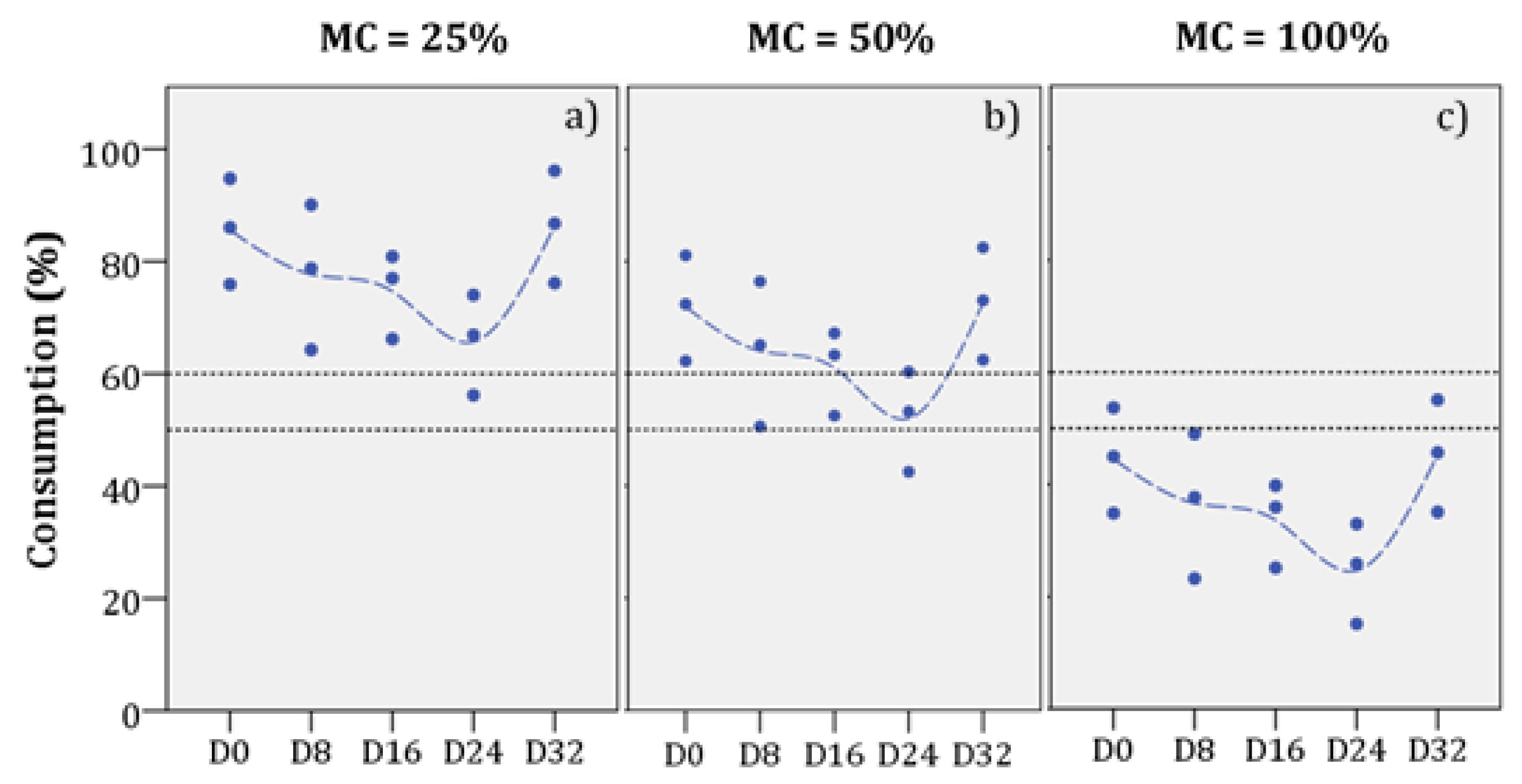
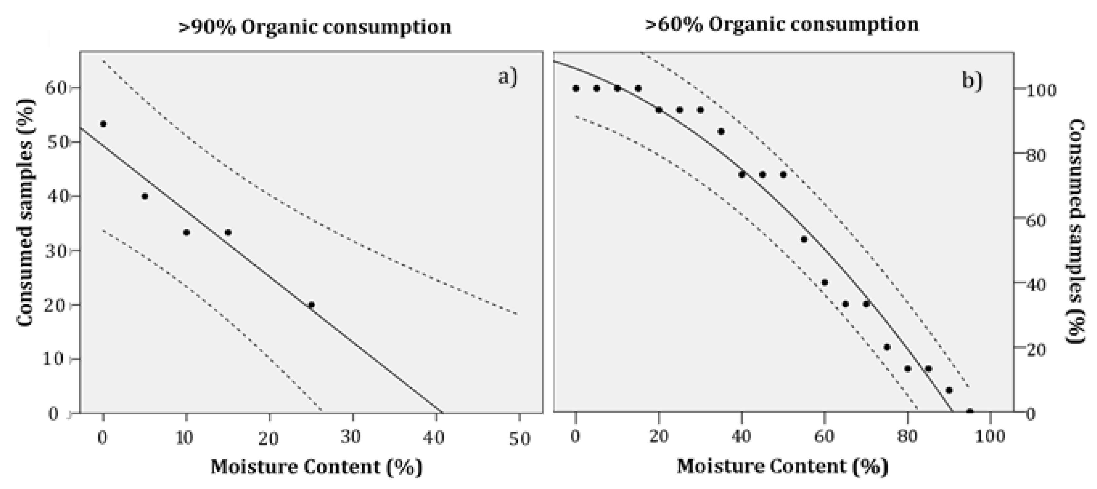
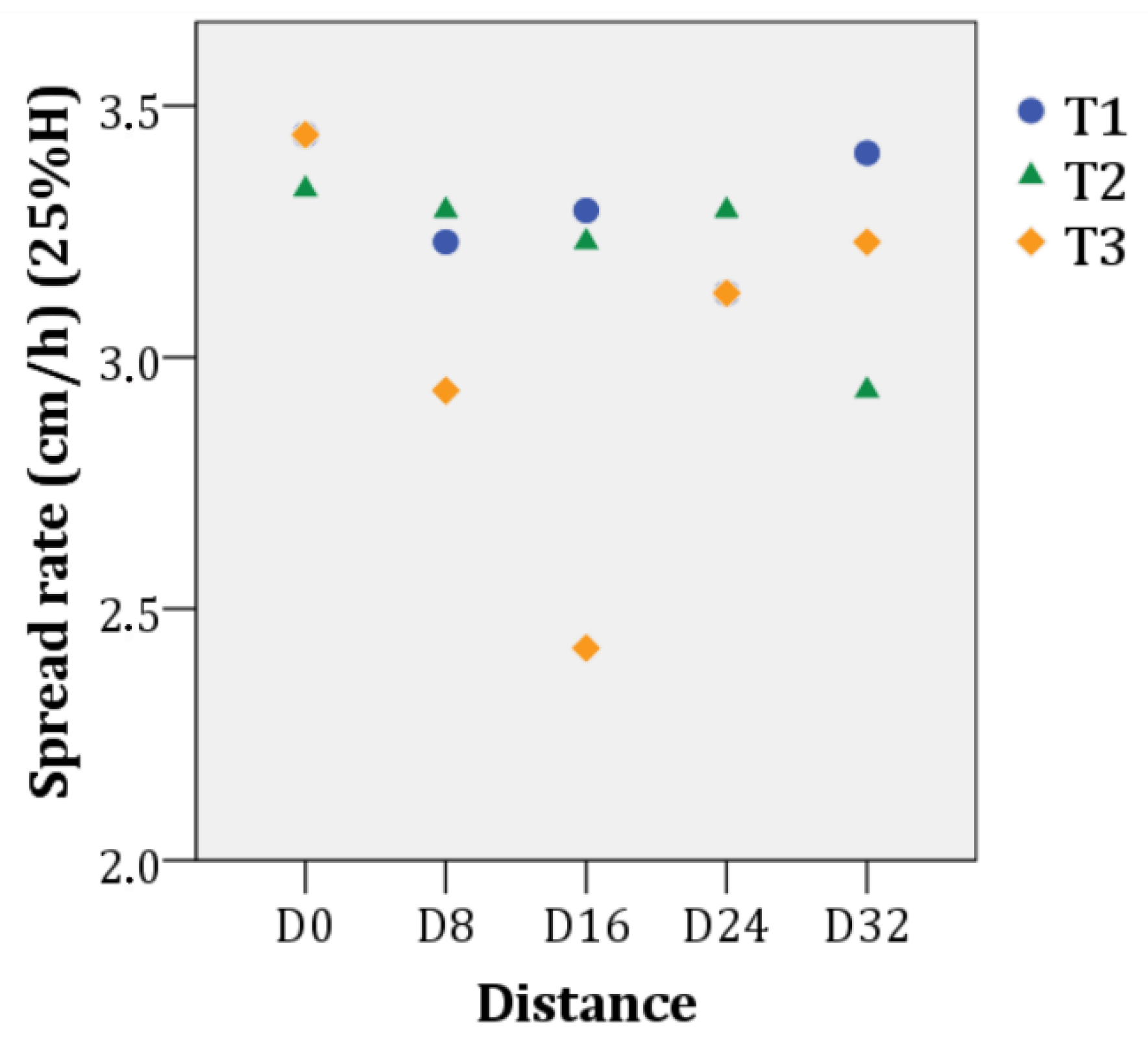
The set of tools provided to evaluate smouldering fire behaviour determined the mean moisture threshold for the occurrence of ignition/extinction of the duff layer and its subsequent propagation is 81.22 ± 20%, with a mean inorganic content of 35.52 ± 11% and a mean bulk density of 156.76 kg/m3. The study identifies the potential total consumption of the duff layer after a fire [that is > 90% of its organic content (Cons90)], which can make up between 20% and 35% of a given surface, with typical moisture content levels for a period of high fire risk (30% and 5%, respectively). The consumption potential at which smouldering combustion can be propagated [>60% (Cons60)] would extend over 93% to 100% of a given surface area. The average propagation velocity at which the combustion would consume falls within a range of 4.08 cm/h to 3.21 cm/h with a moisture content of 5% and 25%, respectively. However, the high heterogeneity in the composition of the fermentation and humus horizons (that is, their mineral content, depth and bulk density) and their moisture content influence the propagation variability of smouldering combustion.
The results of the study, together with the increase in underground biomass and the accumulation of dead fuel in the poorly managed Pinus halepensis forest ecosystems of the western Mediterranean, show that smouldering combustion generates a new parameter in the fire regime that needs to be considered in the future: the “persistence” of fire. The study demonstrates the importance of including smouldering combustion and re-ignitions within the strategic framework for the integration of forest fire risk in forest planning and management. The most important steps to follow are the identification of the re-ignition (or smouldering combustion) potential in the current homogeneous regimes in Catalonia and their integration within the fire risk regime (using soil moisture and edaphological maps), the generation of different models of the propagation of smouldering combustion specific to the forest ecosystems of the northwest Mediterranean, and an analysis of the possible effects of smouldering combustion on current management activities.

 ,
, 


