Article

Smouldering Combustion Dynamics of a Soil from a Pinus halepensis Mill. Forest. A Case Study of the Rocallaura Fires in Northeastern Spain

by
Miquel Àngel Xifré-Salvadó
1,
Núria Prat-Guitart
2,
Marcos Francos
3,*,
Xavier Úbeda
1 and
Marc Castellnou
4
1
Department of Geography, Faculty of Geography and History, Universitat de Barcelona, Montalegre, 6, 08001 Barcelona, Spain
2
Pau Costa Foundation. Mossèn Cinto Verdaguer, 42 baixos A, 08552 Taradell, Spain
3
Departamento de Ciencias Históricas y Geográficas, Universidad de Tarapacá, 18 de Septiembre, 2222, 1010069 Arica, Chile
4
GRAF, Bombers de la Generalitat de Catalunya, Av. de Serragalliners, Cerdanyola del Vallès, 08193 Barcelona, Spain
*
Author to whom correspondence should be addressed.
Appl. Sci. 2020, 10(10), 3449; https://doi.org/10.3390/app10103449
Submission received: 21 April 2020 / Revised: 12 May 2020 / Accepted: 13 May 2020 / Published: 16 May 2020
(This article belongs to the Section Earth Sciences)

Abstract

:
This study analyses the smouldering combustion on soils that took place during the wildfires that occurred in Rocallaura (Northeastern Spain). The smouldering combustion after the first event, 23 June, was the potential source of flaming fire re-ignition of the second event, 19 July 2016. Re-ignitions are an important challenge for the firefighting system. Budget and efforts are spent on controlling these re-ignitions that can ultimately cause the collapse of the response system if the re-ignitions happen during periods of simultaneous fire events. Our objective is to contribute to better understand the dynamics of the smouldering combustion of organic soils associated with these wildfires and the impact on the Pinus halepensis Mill. forest ecosystem. Transects were established in adjacent control and post-fire zones. Laboratory analyses were conducted to determine some physical and chemical properties of both the duff and mineral soil. Using these variables, we estimate thresholds of duff ignition probability, percentage of duff consumption and smouldering combustion spread rates. Overall, we provide a set of tools for evaluating re-ignitions in forest ecosystems. We conclude that the concept of fire persistence should be a new variable for consideration in present and future analysis of fire regimes and demonstrates the significance of introducing smouldering combustion and re-ignition within the strategic framework of the wildfire hazard and integrating these phenomena into forest planning and management.

1. Introduction

Smouldering fires can be defined as slow, low-temperature, flameless combustions, involving both endothermic and exothermic reactions, that propagate via porous materials in a three dimensional fashion [1]. This combustion is the most persistent combustion phenomena known [2,3] and generate the longest and largest fire episodes on Earth, usually occurring in peat and coal deposits in tropical and boreal zones [4]. Smouldering combustion occurs when heat is released and oxygen directly attacks the surface of the solid fuel [2]. The phenomenon is common in porous fuels that form char on heating, for example on wood, duff and peat [5]. The ignition and propagation of smouldering fires in the duff layer depend basically on two physicochemical properties: moisture and inorganic mineral contents [6]. The most important property, however, is the moisture content [7]. In boreal peatlands, the humidity threshold (defined as the 50% probability of ignition/extinction) for a peat sample lies between 110% and 250% moisture, on a dry weight basis [7,8,9,10]. The second most important property is mineral content, the extinction/non-ignition threshold in peatlands being 81.5% [7]. There is a direct and negative relationship between mineral content and moisture determining the ignition threshold of organic matter, since if a sample with a high moisture percentage burns, it means that the mineral content is very low, and vice versa [7]. Lateral spread is more pronounced on shallower surfaces (<2 m), since the oxygen supply is greater [4]. This spread forms a smoldering front which presents a structure composed of four subfronts: those of pre-heating, drying, pyrolysis and oxidation [3]. For most smoldering materials under natural conditions, the two mechanisms that control the rate of spread are the oxygen supply and the heat transfer [2]. At the micro scale, smoldering takes place on the surface of the pores of a solid fuel, while at the macro scale, it is a bulk phenomenon affecting the fuel bed. With depth inside the fuel bed, the loss of oxygen and heat transfer slows down the spread rate. Depending on the fuel bed characteristics and the wind conditions, there are minimum and maximum depths between which smoldering can spread [3]. The concept of optimal depth has yet to be sufficiently studied and could vary widely for different systems on a scale of centimeters to meters [3]. It should be stressed that the spatial heterogeneity in soil moisture content plays a very important role in the variability of smoldering spread [9].
One of the potential causes of smouldering fires is the progressive abandonment of forest management practices in Mediterranean forests. This tendency has occurred for the last 60 years in several Mediterranean regions [11]. The consequence is the increase of understory biomass and, consequently, the increase of dead fuel available and its combustibility, both in flammable and smouldering forms. With time, the accumulation of organic matter in partial decay in flat and humid areas, contributes to increase the depth of uppermost layers with organic soils in a range of decomposition stages. In the case of Mediterranean areas due to the thermal regime is hot in summer and cold in winter, with an average temperature of 12–14 °C and a thermal oscillation of 17–21 °C; with an average rainfall is 350–550 mm; and a period of drought that oscillates between June and August and the frost-free period extends between May and September, both included [12] due to these specific conditions and global change these areas are changing constantly and that it is necessary to understand how these changes affect the soil conditions and combustion characteristics of the forest.
An emergence of different environmental conditions in Mediterranean climates is expected as: an increasing temperature trends and longer periods of drought in the Mediterranean [13,14], the consequent increase in water stress [15,16] and the accumulation of forest floor fuels [17]. These changes could affect the fire regimes by increasing the dry, decomposed fuel accumulation leading to a larger number of smouldering fires and re-ignitions. At the local level, the annual temperature trend (1950–2015) in the study area is + 0.24 °C/decade, winter + 0.17 °C/decade, spring + 0.25 °C/decade, summer + 0.35 °C/decade and autumn + 0.19 °C/decade. The indicator of duration of the warm spell (IDWS) and the indicator of duration of the season of growth (IDSG) present a statistically significant positive trend, with an increase of 2.9 days/decade [18]. These changes in temperature extremes in the two seasons when the risk of fires is highest (spring and summer) may, in the future, result in an increase in the number of fires and changes in the fire regime [19]. The increase in drought conditions and the water deficit in spring and summer are likely to cause greater risks of forest fires [19]. According to forecasts made by Barrera–Escoda et al. [20] and Gonçalves et al. [21] and described by Calbó et al. [14] for the Mediterranean-continental climate zone, the mean annual temperature will increase by + 0.7 [+ 0.5 / + 1] °C in 2021. This increase would be greater in summer (+ 0.9 [+ 0.5 / + 1.5] °C) than in the other seasons. Annual precipitation would vary significantly, with a possible increase of + 0.7 [− 14.1 / + 8] %, but it could vary seasonally, with an increase in winter, but with losses in the other seasons of the year. All these projected changes would have a major impact on the already scarce water resources of the zone.
The duff’s bulk density, porosity and organic composition are other important properties that have a direct impact on the ignition and propagation of smouldering fires [4]. The bulk density directly influences the fire ignition and extinction properties of organic matter, the critical moisture for extinction is higher than the critical moisture for ignition [22]. In addition, the bulk density influences the depth of combustion and the critical moisture threshold for extinction, since it regulates the oxygen supply, permeability and thermal inertia [22,23]. The use of models that analysed combustion characteristics have been used in different ecosystems but in few cases for the Mediterranean ecosystem [1,3,7,9]. Soil characteristics and its changes and effects in these combustion characteristics have been analysed inn various manuscripts [6,8,22,23] but in any of them the soil analysed properties are in none of them was the number of soil variables analysed so high, giving this study a very high value and representativeness.
In the Mediterranean region, smouldering combustion has been little studied as in general the region’s soils have low levels of organic matter accumulation. However, in the Mediterranean soils that do accumulate organic layers, the relevant impacts of smouldering include the break-out of new flaming fires, the release of carbon from the soil into the atmosphere and the release of C stored in the soil’s organic matter [7].
The particular case study of the Rocallaura Fires, also bring to light the need to bridge the gap between science and management. During the fire season in the Mediterranean region, the emergency response system is highly stress attending the several fires that break out continuously. Every fire emergency needs to be dealt efficiently with the minimum resources and time, especially if there is risk of simultaneous fire events that could stress the system even more [24]. The fact, that the Rocallaura fires had organic soils smouldering, required extra efforts from the Catalan Fire and Rescue Service forest fire units to control the smouldering fire that finally reignited a flammable fire jeopardising the organisation’s efficiency and finally impacting on population at risk. Better understanding the behaviour of smouldering fires in Mediterranean organic soils, contributes towards better informed science-based decisions in fire management. For the reasons described the smouldering combustion of soils in Mediterranean environments require further study.
The aim of this study is to better understand the conditions under which smouldering combustion propagates in organic soils in Mediterranean-type ecosystems. To achieve this goal, first, the properties of the soils that sustain smouldering combustion in the area were analysed, this included the organic content, inorganic content, bulk density, moisture of the duff layer. Second, the fire impact on soil and third its combustion characteristics (ignition, consumption and subsequent propagation) using models designed in various studies and applying them to the specific case of a Mediterranean forest.

2. Material and Methods

2.1. Study Area and Fire History

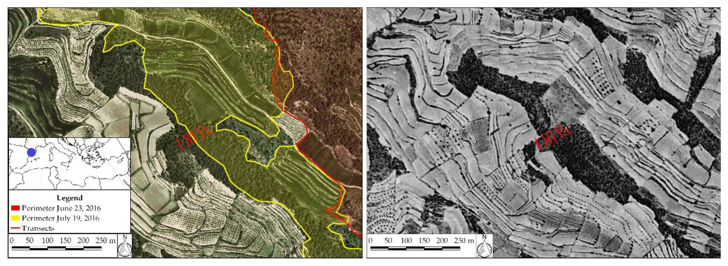
The study area lies in the Serra de Senadelles, between the villages of Rocallaura (municipality of Vallbona de les Monges) and Nàlec, Lleida (41°31′28.0″ N 1°07′12.1″ E, 615 m a.s.l.) in the Northeast of the Iberian Peninsula (Figure 1).
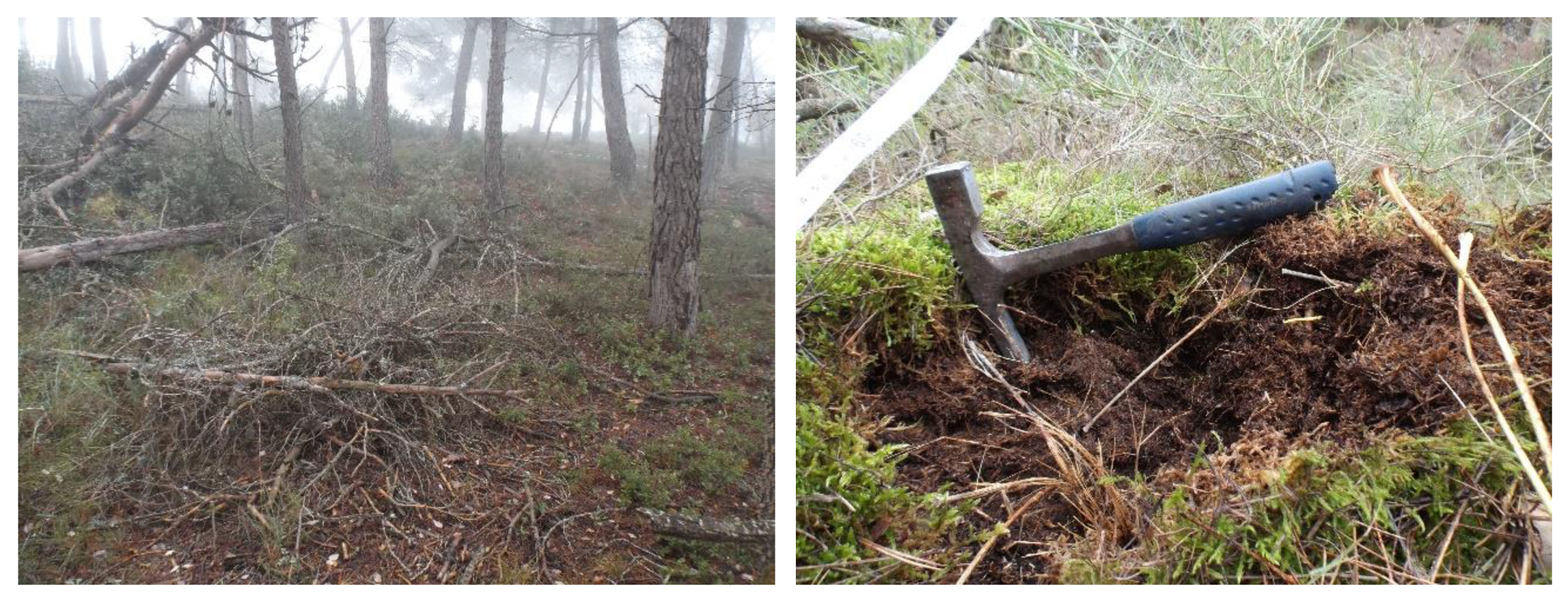
The study area’s forest is composed of a dominant tree stratum of Pinus halepensis Mill (42 aa CORINE) [25]. The shrub stratum consists mainly of Phillyrea latifolia, Quercus coccifera, Pistacia lentiscus, Quercus ilex, Erica multiflora and Rosmarinus officinalis. The herbaceous stratum is dominated by several species of moss, Brachypodium retusum and some individuals of the Orchidaceae family (Figure 2). The area has a normalized difference vegetation index (NDVI) of between 0.2 and 0.4 [26]. The Pinus halepensis reaches an average height of 7 m to 11 m with a typical diameter at breast height of between 15 cm and 20 cm and a basal area of 20 m2/ha to 30 m2/ha. Leaf biomass oscillates between 3 and 5 t/ha, and total biomass between 60 t/ha and 120 t/ha [27].
The trees have a maximum age of between 70 and 80 years and have not, in fact, been cut or burned since the Spanish civil war (1936–39). A line of trenches dug in the area during the conflict, and the associated risk of explosion of ancient artefacts, explains why the forests have been exposed to little management activity since the late 1930s. This fact, combined with rural abandonment, has resulted in the growth of moss and an increase in forest floor duff in zones with little slope.
The geological substrate is formed by Cenozoic sedimentary deposits. The lower part of the substrate contains marls with calcareous intercalations (Rupelian-Chattian); the middle contains shales, sandstones and calcareous forms (Rupelian-Chattian); and, the upper part contains clays, silts and fine-grained sandstones with intercalations of conglomerates (Rupelian) [30]. Soils are classified as Haploxeroll lithic [31] and the characteristics have been specified in Table 1.
On 23 June 2016, the first fire broke out affecting 103 ha of forest and agricultural land near the village of Rocallaura (Vallbona de les Monges, l’Urgell) (Figure 3). On 25–29 June, various re-ignitions were recorded by the firefighting crews in different areas of the burned zone. On 4, 7 and 10 July, re-ignitions were registered in the forest floor and on tree trunks and stumps that continued to sustain smoldering combustion. No rain occurred during the period. On 18 July another re-ignition was registered burning 500 m2. On 19 July the second fire broke out affecting a total area of 790 ha of forest and cultivated fields and threaten the Wildland Urban Interface in a day with simultaneous fire events. The re-ignition of the same area was attributable to the smouldering combustion that persisted in the areas where the previous fire was suppressed.

2.2. Experimental Design and Field Work

Three months and twelve days after the second fire (4 November 2016), six 40 m long transects were designed following the direction of maximum slope in order to cover a range of variability in the area, from which a total of 66 samples were taken (Figure 4). Three transects were located in the burned zone, classified as having been subject to a low-intensity fire [32], and the other three in a control zone contiguous to the burned area and with similar characteristics. The area was selected for showing evidences of being an area prone to smoldering combustion of soils. After indication from the Catalan Fire and Rescue Services in charge of the fire suppression operations, the area designated for sampling was identified as being the source of the second fire, an area where the several smoke plumes originated by the combustion of organic soil layers were detected repeatedly in the time between both flaming fire events.
Soil samples were taken every eight meters (five samples per transect in the control zone and six per transect in the burned zone) of approximately 0.4 kg. In the control zone (C), three types of sample were taken according to their depth: organic layer or duff (excluding leaf litter) and soil layers between 0 cm to 5 cm and between 5 cm to 10 cm. In the burned area (F), because the duff had partially burned, samples could not be obtained from all the points and were limited to two specific depths (0–5 cm and 5–10 cm). D0 of the burned area are close to the zones were the smouldering combustion of soils took place. Then the number of total soil samples were 66, 30 from control zone and 36 from fire affected area. Duff samples were only collected in control area being a total of 15 samples.

2.3. Laboratory Analysis

Laboratory analysis were carried to determinate the physical and chemical properties on mineral and duff (Oe + Oa) (bulk density, inorganic and organic carbon, organic matter and inorganic matter). Soil organic carbon, inorganic carbon, organic matter and inorganic matter were measured using the loss-on-ignition (LOI) method [33,34]. Mineral soil bulk density was analysed using the Périé and Ouimet [35] empirical model and organic bulk density was analysed using Federer et al. [36] model.
For the analysis of organic matter, the 3 variables C inorganic, C organic, and carbonates, work with a pulverized sample. A total of 1 g of dry sample at 60 °C is placed in a high temperature resistant glass. Subsequently, the samples are placed in the oven for 12 h at 105 °C in order to completely remove the humidity from the samples. The samples are allowed to cool in a hood for about 30 min and weighed again. Once all this is done, heat the muffle oven to 550 °C and place the samples for 4 h. After these four hours the samples are removed from the muffle, and they are again allowed to cool in a hood for approximately 30 min and are weighed. To conclude, the muffle is heated to 950 °C and the samples are placed again for 2 h. Finally, the samples are removed from the muffle and allowed to cool in a hood for 1 h to 2 h and they are weighed for the last time. Bulk density was calculated based on measured soil mass and soil volume exclusive of the >2-mm coarse fragments. The Federer model followed the theoretical relationship Db = DbmDbo/[FoDbm + (1−Fo) Dbo] where Db is the bulk density (Mg/m3), Fo is the organic fraction (kgo/kg), Dbo is the bulk density when Fo = 1, and Dbm is the bulk density when Fo = 0. The relation arises from assuming that (i) Dbo, the bulk density of “pure” organic matter, and Dbm, the bulk density of “pure” mineral matter, are constant and (ii) in a mixture, the volumes occupied by the organic mass and the mineral mass are additive. When these parameters are known, Db can be estimated from Fo, which is more easily measured. When Fo is greater than 0.1 kgo/kg, the organic mass per unit soil volume (FoDb), or organic density, is approximately constant at 0.1 Mgo/m3.

2.4. Statistical Analysis

Data normality and homogeneity of variances were tested using the Shapiro–Wilk and the Levène tests. For those variables in mineral soil samples that satisfied assumptions of normality and heteroscedasticity, statistical comparisons were conducted using the parametric t-Student. For those variables in mineral soil samples that satisfied only normality or homogeneity, the non-parametric U-Mann–Whitney was used.
Smoldering combustion properties of control zone duff samples (N = 15) were estimated using three empirical models [8,9,23], based on soil-property similarities (Table 2). Duff ignition probability was estimated using the empirical model described in Frandsen [8]; percentage fuel consumption was estimated using the Garlough and Keyes [23] model and spread rate propagation was estimated using the Prat-Guitart et al. [9] empirical model. Statistical software IBM SPSS Statistics v. 23 (IBM Corp. Released, 2015) was used for data analysis.

2.5. Probability of Smoldering Fire Ignition in Organic Soils

The probabilistic method was designed by Frandsen [8]. This method relates the probability of ignition with the content of inorganic matter, the bulk density and the moisture content of the sample Equation (1):
P = 1/(1 + exp−(B0+B1xH+B2xIM+B3xBD))
where B0, B1, B2 and B3 are coefficients that vary according to the probabilistic distribution of each sample group. H is the moisture content, in %, IM is the mineral content, in %, and BD is the bulk density kg/m−3. The calculation of the moisture content was done at a probability of ignition of 50% (P50) for each sample. Then, the result is expressed as the maximum moisture content given for ignition to occur. Isolating the percentage of maximum moisture content at a probability of 50% results in Equation (2):
H (%) = (B0 + B2xIM + B3xBD)/B1
Given the lack of tools to experimentally analyze ignition on the samples collected, the probability coefficients used (B0, B1, B2 and B3) are Frandsen [8] for the sample group ‘Pine duff (Seney)’ (Table 3). This sample group have similar mean values of inorganic matter (IM, 36.5 ± 16%), organic matter (OM, 63.5 ± 16%) and bulk density (BD, 190 ± 19 kg/m−3) at a 5 cm depth as the samples collected in Rocallaura (Table 2).

2.6. Experimental Design to Examine the Effect of Soil Moisture and Bulk Density on the Smoldering Spread Rate

The spread rate of samples that could smolder is estimated using the linear regression model proposed by Prat-Guitart et al. [9] (Equation (3)). This model estimates the spread rate in relation to the moisture content and bulk density by experimental analysis of commercial peat smoldering ignition at different bulk densities. The samples used in Prat-Guitart et al. [9] had a depth of 6 cm, an average mineral content of 3% and bulk density ranges that were representative of peat and humus in peat bogs (50 kg/m3 to 150 kg/m3) and, therefore, comparable to the bulk densities of the organic stratum (Oe + Oa) of this study (48 kg/m3 and 190 kg/m3). The greatest difference with the samples from this study lay in the mineral content (mean 35%).
Log (Vp) = A0 + A1 × MC + A2 × BD + A3 × MC × BD + ɛ
where Vp is the velocity of propagation or spread rate (cm/h), MC the soil moisture, estimated using dry mass basis (%), BD the bulk density (kg/m3), A0, A1, A2 and A3 are the coefficients of the dependent variables and ɛ is the residual term. Given that we do not have the necessary tools to perform the same experiments and so obtain the model coefficients, we opted to use those that provide the best fit with the linear model proposed by Prat-Guitart et al. [9] (R2 = 0.77) and as is detailed in Table 4.

3. Results

3.1. Comparative Findings: Control Zone vs. Post-fire Zone in Mineral Soil

Descriptive statistics about bulk density, organic and mineral matter are reported in Table 5. Soil bulk density (BD) increases significantly with depth, both in the control zone (U (26) = 29, p< 0.001) and in the post-fire zone (t (28) = − 6.25, p < 0.001, r = 0.76). BD presents significantly lower levels in the post-fire zone at depths of both 0–5 cm (t (28) = 2.92, p < 0.01, r = 0.48) and 5–10 cm (U (27) = 44, p < 0.01). Soil organic matter (OM) content falls with depth both in the control zone (t (27) = 4.27, p < 0.001, r = 0.64) and in the post-fire zone (U (28) = 9, p < 0.001). Levels are slightly higher in the burned area, at depths of both 0–5 cm (U (28) = 56.5, p < 0.05) and 5–10 cm (t (27) = − 2.62, p < 0.05, r = 0.45). Soil inorganic matter (IM) content is inversely proportional to the SOM content.

3.2. Descriptive Analysis of the Duff Layer in the Control Zone

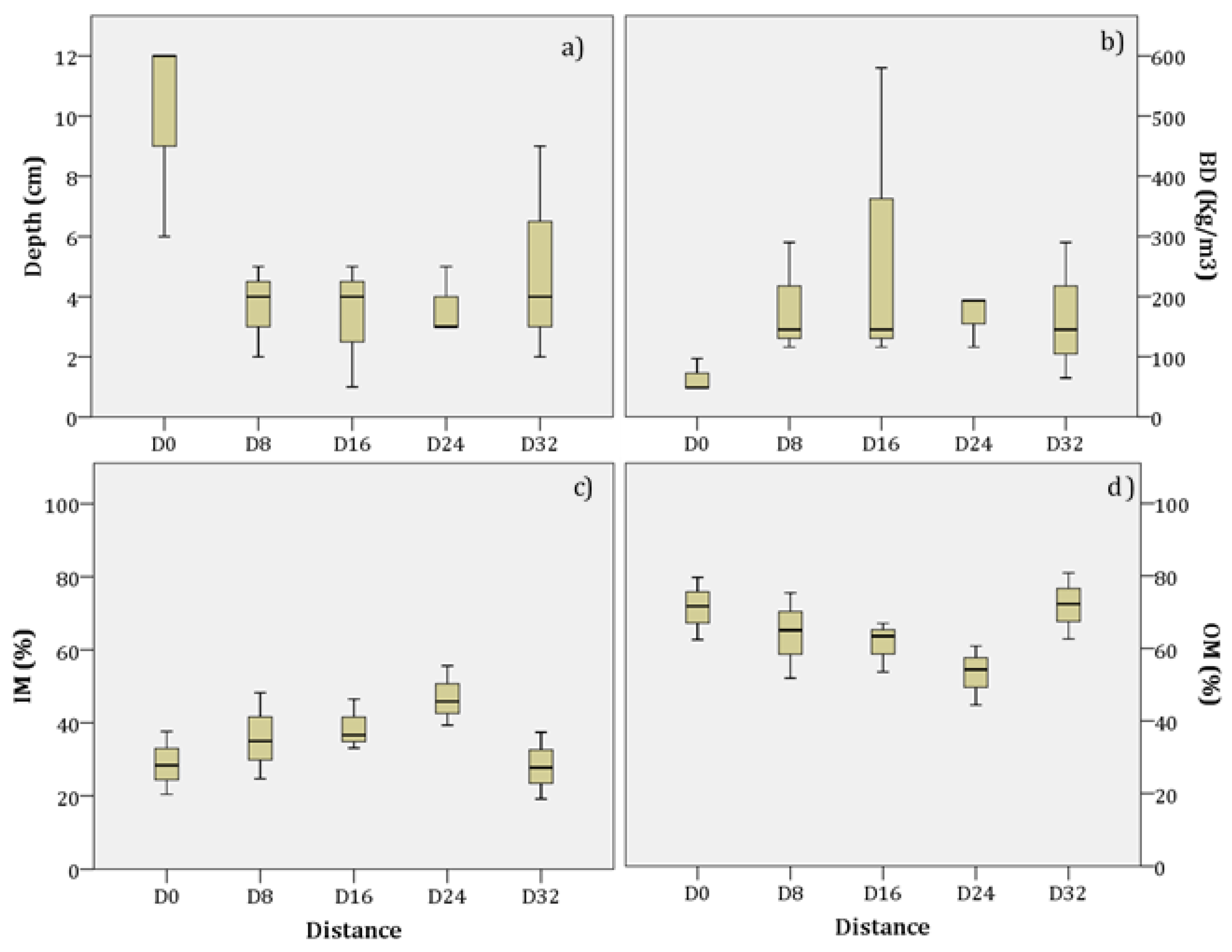
The mean depth (Figure 5a) of the duff layer (Oe + Oa) is 4.98 ± 3.4 cm, with a maximum of 12 cm and a minimum of 1 cm. In the highest part of the transects (D0) (Figure 4), the mean depth is 10 ± 3.5 cm, which is much deeper than at other parts of the transects. Between sample points D8 and D24, the means range between 3.67 and 3.33 cm. In the lowest part of the transect (D32), the mean depth is 5 ± 3.6 cm, with depths ranging from 2 to 9 cm. Bulk density values are the inverse of those of depth (Figure 5b). The mean density is 157 ± 134 kg/m3 but values fluctuate greatly, especially in D16. The highest part of the transects presents a mean density of 64.44 ± 27.9 kg/m3, which is much lower than at other parts of the transect. The mean inorganic content is 35.52 ± 10.5%. It can be seen (Figure 5c) that the inorganic matter content rises (D0 = 28.80%) along the transect to a distance of 24 m (D24 = 46.93%). Thereafter, the mineral content decreases until the end of the transect (D32 = 28.10%) (Figure 5c). The organic content is, logically, inversely proportional to that of the inorganic content, with a mean value of 64.48 ± 10.5% and a maximum of 80.84% and a minimum of 44.39% (Figure 5d).

3.3. Duff Ignition Probability

We estimated the 50% ignition probability (P50) in all the duff samples (N = 15) and in six soil samples taken close to the surface (F 0–5 cm, N = 15) from the area exposed to low-intensity burning. All the surface soil samples (C 0–5 cm, N = 15) taken from the control zone, in contrast, do not present a P50 of ignition.
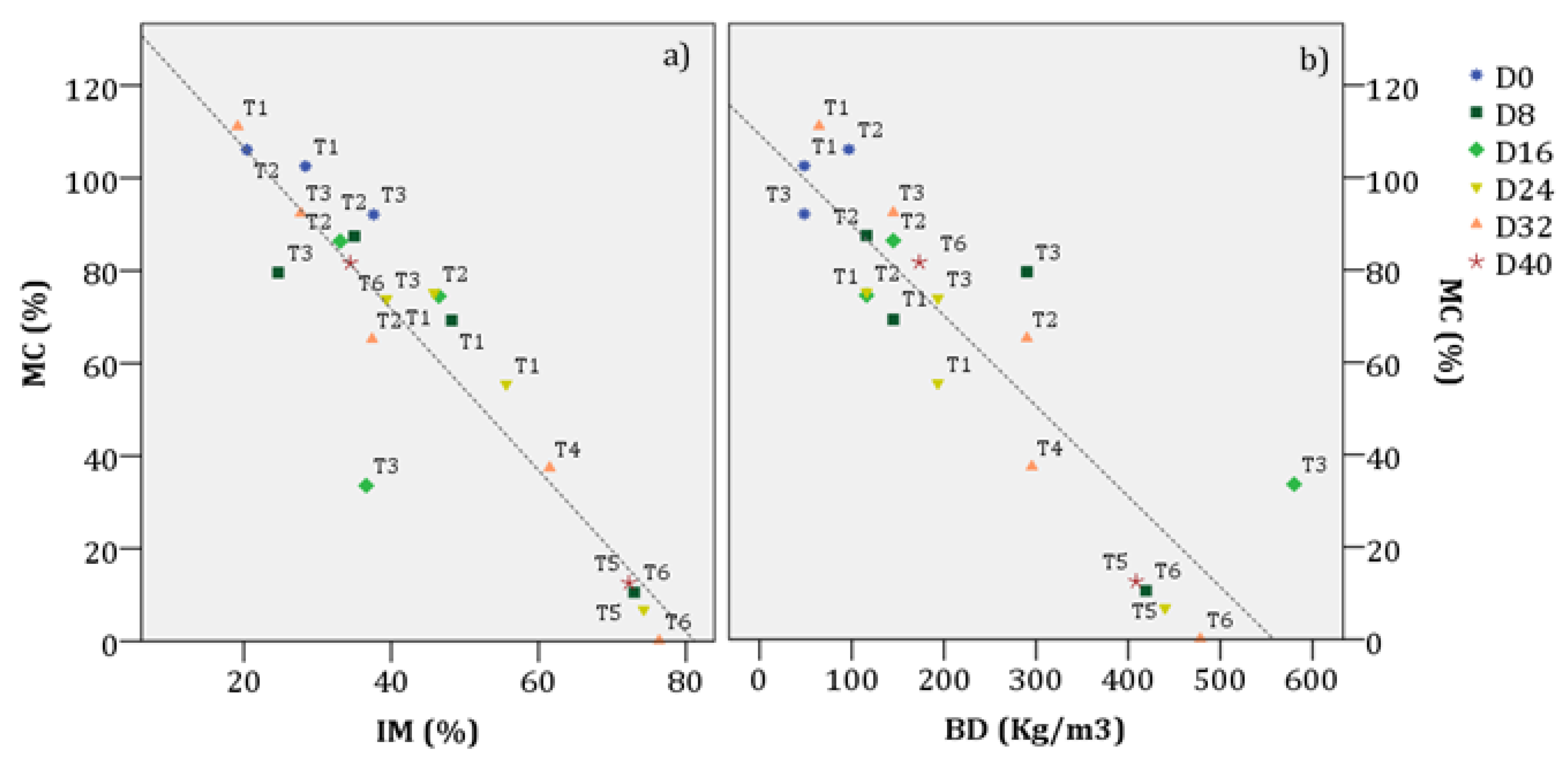
The separate linear regression model between percentage of soil moisture content (% MC) at P50 and percentage inorganic matter (% IM) has a very high magnitude (F = 104.5, p < 0.001) and a coefficient of determination (R2 = 0.846) (Table 6a). In the separate linear regression model between % MC at an ignition of P50 and BD expressed in kg/m3, the magnitude (F = 70.9, p < 0.001) and the coefficient of determination are also high (R2 = 0.789) (Table 6b).
The mean moisture threshold for P50 is 81.22 ± 20% and 23.08 ± 31% for the control and burned zone respectively. The inorganic matter content means are 35.52 ± 11% in the duff and 66.40 ± 16% in the F−0–5 cm (Figure 6a). The organic matter content means are 64.48 ± 11% in the duff and 33.6 ± 16% in the F−0–5 cm. The mean bulk density is 156.76 ± 135 kg/m3 in the duff and 373.90 ± 114 kg/m3 in the F−0–5 cm (Figure 6b).
In the burned zone, the minimum moisture estimated is 0.12% corresponding to sample D32 from T6. The next lowest value is 6.80%, corresponding to sample D24 from T5. These two results mark the maximum limit of inorganic content and density for P50 (76.36% and 74.26% of IM, 478.31 kg/m3 and 439.87 kg/m3 of BD, respectively).
In the duff layer of the control zone, soils can reach P50 when moisture content is as lower as 33.60%, IM is 19.16% and bulk density is 580 kg/m3 (sample D16 from T3), although the sample is not an extreme that can be considered representative of the whole layer. The next lowest moisture content 55.62% recorded in sample D24 from T1 associated with an IM of 55.61% and a BD of 193.33 kg/m3. This value can be considered as being more representative of the duff layer. The highest bulk densities are recorded in samples D32 from T2 and D8 from T3 with 290 kg/m3 each.
The linear regression model, between the percentage moisture, the inorganic matter (IM) and the bulk density (BD), predicts that for the soils analysed, each 1% increase of MC, the IM will have to decrease 0.01% while the bulk density decreases 0.01 kg/m3 in order to reach a 50% probability of ignition (Table 7). In the case of duff, the regression line obtained was inversely proportional to the inorganic content and the density of the samples. Table 6 shows the results of linear regression model in order for a soil of the same physicochemical characteristics to have a 50% probability of combustion. In the model, the interaction between the two variables (IM × BD) was not included because the magnitude of the equation did not vary significantly. Figure 7a shows that if soil moisture increases then both the inorganic content and the density have to fall for there to be a 50% probability of ignition. In the case of duff, the higher its organic content, the lower the level of moisture needed for combustion at P50 (Figure 7b).

3.4. Percentage Fuel Consumption in the Duff Layer

Less than 50% by volume of all the duff layer samples from the control zone (C 0–5) were consumed. At moisture levels between 0% and 5%, in two samples from F 0–5 more than 60% by volume were consumed. The samples corresponded to D24 from T5 with 63.4% and 60.67% consumption for 0% and 5% MC, respectively; and sample D40 from T6 with 93.06% and 90.32% for 0% and 5% MC, respectively. At a moisture level between 10% and 25%, only in sample D40 from T6 was more than 60% of the material consumed.
At a moisture content between 5% and 10%, samples from the duff layer combust in 100% of the cases, with a mean consumption of each sample of 90.76 ± 10%, 88.51 ± 10% and 86.10 ± 11%, respectively (Figure 8).
At 25% MC, the mean rate of consumption is 78.20 ± 12%. At 50% MC, 73.33% of the samples continue to combust more than 60% of their organic content. For samples that can maintain combustion (<60%), the mean consumption is 76.05 ± 12% of the sample. At 100% MC, all the samples do not exceed 60% consumption and they are unable to sustain smouldering combustion. The mean at this humidity results in a consumption of 37.16 ± 12% of each sample (Figure 9).
As for the percentage consumption of the duff horizon in relation to the mean transect slope, it can be seen that it is directly proportional over the first 24 m (D24). From D0 (0 m) to D24 (24 m), the percentage of consumption decreases as the altitude gradient falls. Between D24 and D32, percentage consumption rises again.
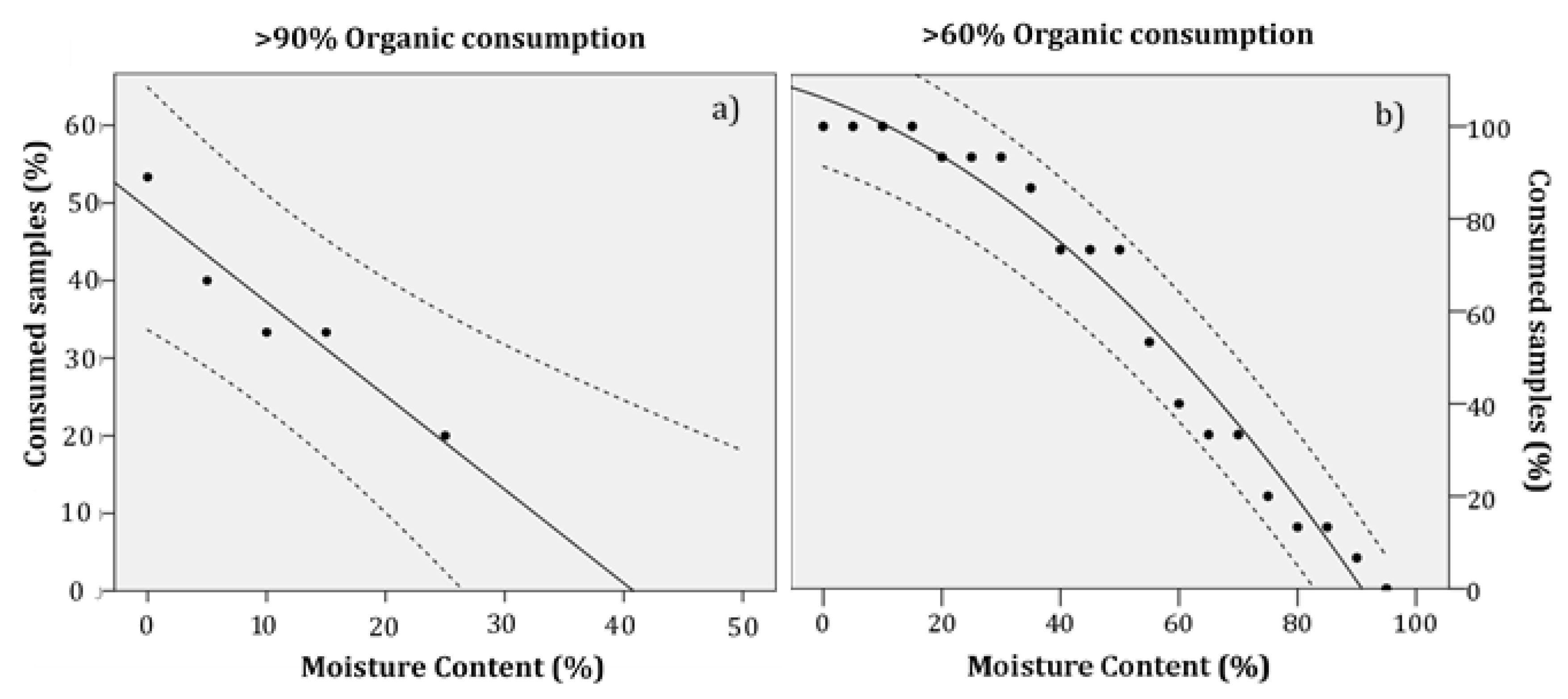
Figure 10a and Table 8a show the regression line that expresses the percentage of samples consumed at 90–100% according to their percentage humidity. The regression has a very high coefficient of determination (R2 = 0.919) and a high magnitude (F = 34.09, p < 0.01). The regression line can be expressed as:
Cons90 = 49.28 − 1.21 × MC (%)
where Cons90 is the percentage of samples of which more than 90% is consumed and MC (%) is the respective soil moisture content. This line seeks to provide an estimate of the maximum humidity limit so between 90% and 100% of each sample is consumed, which means that smouldering combustion can propagate easily. At rates of soil moisture between 5% and 15%, it is estimated that between 35% and 40% of the samples will be consumed more than 90% of their organic content. At 25% MC, the number of samples falls to 20%.
Figure 10b and Table 8b show the linear regression models of the percentage of samples consumed > 60% according to humidity. It can be seen that the quadratic regression that expresses the percentage of samples consumed is higher than 60% according to the percentage of soil moisture content. The regression has a very high coefficient of determination (R2 = 0.969) and a very high magnitude (F = 295.26, p < 0.001). The quadratic regression can be expressed as:
Cons60 = 106.087 − 0.475 × MC − 0.08 × MC2
where Cons60 is the percentage of samples of which more than 60% is consumed and MC (%) is the respective moisture. This line seeks to provide an estimate of the maximum moisture limit so that more than 60% of each sample is consumed and, therefore, of the point at which smouldering combustion is sustained.

3.5. Smoldering Combustion Spread Rate

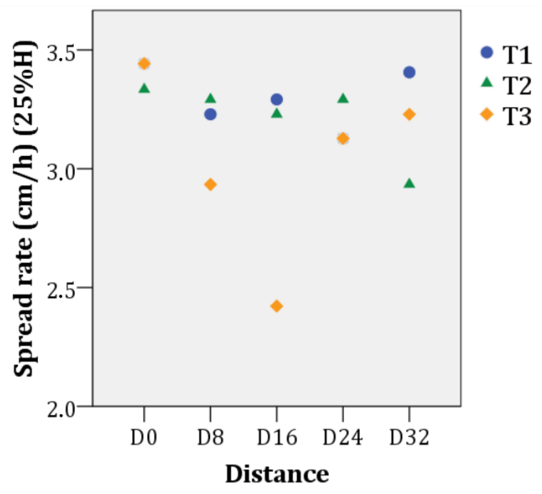
Table 9 and Figure 11 show the means, maxima and minima spread rates (Vp) for the samples that can maintain smoldering fires at different moisture contents. With a 5% moisture content, the spread rate at which the organic stratum (Oe + Oa) would be consumed is 4.08 ± 0.4 cm/h; with a 10% moisture content, it falls to 3.84 ± 0.3 cm/h; with a 25% content, it falls to 3.21 ± 0.3 cm/h; with a 50% content, it falls to 2.38 ± 0.03 cm/h; and, finally, with a 100% moisture content no samples would be capable of maintain smoldering fires and, therefore, the fires would not spread.

4. Discussion

4.1. Smouldering Fires in the Duff Layer

The duff layer or organic stratum plays a critical role in the magnitude of possible ecological changes in the wake of a fire [37]. In the Mediterranean, it contributes significantly to soil fertility, regulating the availability of N-p-K [38]. After a fire, the duff layer may remain intact, or undergo partial or total combustion (depending on the fire intensity). The structure of the duff layer tends to become more heterogeneous after a fire [39], although this is largely dependent on its mineral composition [40].
Duff layers of 4 cm to 12 cm in depth can easily maintain smouldering combustion [41] and, here, at the top of the burned transects a greater reduction in duff was observed compared to figures recorded for the control zone. The bulk density in that areas is very low (e.g., D0), which means it is more porous and can burn more easily [3]. The low moisture content (<15% MC) of the duff layer, resulting from the meteorological conditions that occurred during the fire season, is another factor explaining why part of the duff layer burned.

4.2. Impacts of Smouldering for the Mediterranean Ecosystem

The elimination of the duff layer has a considerable physiological impact on plants, since it alters their nutrient and microorganism dynamics [39,42]. Contradictory reports have been made about the survival of seeds post-fire in ecosystems dominated by Pinus pinaster Ait. Some studies claim that the germination and initial survival of this species is more likely when the entire duff layer is eliminated by combustion and the soil is altered [43]. Others argue that the smouldering combustion of duff hinders the post-fire regeneration of this species, although it can be beneficial if the needles and/or combustion materials cover the soil after the fire [44].
Reports from the field show that a complete combustion of the entire duff layer in the soil does not occur and, that, together with the significant contribution of needles from the aerial part of the forest, this can avoid major problems of erosion and nutrient availability in the mineral layer [39].
The high emission of carbon into the atmosphere produced by smouldering fires in peatland systems in tropical and boreal zones [4] is not comparable with carbon emissions in the Mediterranean, since the amount consumed by smouldering combustion of duff is very low compared to these places.

4.3. Probability of Ignition and Fuel Consumption in the Duff Layer

The most important factors for the ignition and consumption of the soil duff layer are the maximum temperatures reached and the duration of these temperatures during a forest fire [41]. The longer the time during which the duff is subject to high temperatures, the lower the heat energy needed for ignition [45]. Thus, the minimum heat flux estimated for the ignition of a peat bog, with a moisture content of 10%, is 10.5 kW/m2 during 3 min of high temperatures and 5.8 kW/m2 during 30 min [45]. The composition of the duff (mineral content, moisture, bulk density and depth) also appear to determine the probability of its ignition and consumption [7]. The mineral content is one of the most important properties determining the smouldering combustion of fine organic layers [46], as it was in this case study.
The moisture content of duff layer in Mediterranean summer months can vary between 5% and 30% [44,47], but this depends greatly on their state of decomposition and on their composition [23,48]. At these relatively low rates of moisture content, oxidation at the combustion fronts can produce enough energy to dry the duff and ensure propagation spread [10,22]. Moreover, increasing temperature trends and longer periods of drought in the Mediterranean [13,14], together with the consequent increase in water stress [15,16], are likely to increase this risk of ignition and consumption and propagation within the duff layer.
Moisture content with a 50% ignition probability (P50) is defined as the threshold at which ignition occurs [7] (Figure 6 and Figure 7). The ignition results show that, due to extremely low levels of moisture content in the period of fire risk in the Mediterranean, the soil duff layer can easily combust. For ignition to occur in this study, approximately 75% mineral content (25% organic content) at 5% moisture content was estimated to be sufficient. The results also show that an increase in bulk density reduces ignition and propagation probability [8,9].
Most studies of combustion in the duff layer agree that an increase in mineral content decreases ignition probability [8,23]. However, the addition of soluble salts, such as calcium and magnesium, can act as catalysts in the oxidation of carbon, favouring the propagation of combustion [46]. This study has not undertaken a characterization of soluble salts in the duff layer, but in light of the high concentration of Ca2+ cations in the mineral soil it can be considered that the mineral composition of the duff layer is playing a role on the estimated combustion parameters.
The results of the study show that to obtain a consumption of above 90% and 60% of the duff sample (Cons90 and Cons60 respectively) and to achieve subsequent propagation [46], the mineral content values need to be lower than 55% and 40%, for moisture contents of 5% and 25%, respectively. Here, it is worth mentioning that Garlough and Keyes [23] did not include bulk density in their model because they did not observe a significant influence in the percentage variation of the consumption of their samples.
The spatial variability in consumption can be determined by the percentage (>60% and >90%) of samples consumed. In this study, we have estimated that at a moisture content of 60%, half the samples would consume more than 60% of their organic content. If the moisture content (5% and 15% MC) is fixed at the levels prevailing during the re-ignitions, between 35% and 40% of the samples would consume more than 90% and all the samples would consume more than 60% of their organic content. These results highlight the heterogeneity of the O in terms of inorganic content and how this can influence spatial propagation after a fire.
We should stress the importance of other factors that may favour ignition and increase consumption over a prolonged period. These include ignition vectors, such as pine cones, that are capable of initiating and prolonging smouldering combustion in the duff layer [49]. Pine cones, for example, can initiate duff smouldering, while the properties of the O (% MC, % IM, BD) condition propagation [49].
The heterogeneous composition of the fuel, including such properties as mineral content, bulk density, depth and the presence of pine cones, together with the spatial heterogeneity of the moisture content, are important mechanisms influencing the spatial variation of the smouldering combustion of duff [47].

4.4. Determination of Smoldering Combustion Spread Rate

The smoldering combustion spread rate is a multidimensional phenomenon made up of two components: in-depth vertical and surface lateral spread. Here, only the lateral spread rate could be estimated. In-depth spread could not be estimated as we did not have the resources required to quantify the calorific energy of the organic matter [50].
The spread rate falls as the moisture content rises and increases at greater wind speeds [50]. For a given moisture content, if the bulk density increases, more energy input is needed to continue smoldering combustion [9]. In contrast, high bulk density peat produces more energy due to the oxidation of more mass [2], but it tends to retain more moisture content. This water has to be evaporated by the drying subfront before the arrival of the pyrolysis and oxidation subfronts [3].
An estimated range for the smoldering combustion spread rate in peat has been described by Huang et al. [50]: it varies between 25 cm/h (with wind speeds of 4.3 cm/h and a moisture content of 5%) and 2 cm/h (without any wind and 100% moisture). This study shows that, on the days that the re-ignitions took place, the mean smoldering combustion spread rate was approx. 3.84 ± 0.34 cm/h. This rate was estimated for an organic horizon (Oe + Oa) with a 10% moisture content, without wind and with a mean bulk density of 160 kg/m3. If the surface in the study area were homogeneous, smoldering combustion could begin at 92.16 ± 8.16 cm/day.
Starting from the fire on 23 June 2016, the spread distance could be estimated, on the condition that all the re-ignitions were a consequence of smoldering combustion and the spread was linear, homogeneous and without wind. For example, on the 25–30 of June 2016, the estimated radial distance affected by smoldering would be 1.84 m, 2.77 m, 3.69 m, 4.61 m, 5.53 m and 6.45 m, respectively. On the 4, 7 and 10 of July 2016, the burnt radial distance would reach 10.76, 12.90 and 15.67 m, respectively. And on 19 July, the radial distance would be 23.96 m. With a mean daily wind speed of 7 km/h, this rate would increase [50].
We should stress that, unlike in the model described in Prat-Guitart et al. [9], the bulk density of the samples in the present study did not vary in terms of their moisture content. This indicates that the spread rates obtained may be underestimated and that the actual rate could be higher, especially at high moisture contents. In contrast, the high mineral content of the study samples (35% IM in this study compared to 2.6% in Prat-Guitart et al. [9]) would probably reduce the spread rate [7], although the high presence of Ca2+ and Mg2+ cations could well increase heat transfer and, therefore, the spread rate [46]. Thus, we only estimated rates that might differ from those in reality, but, nevertheless, they should serve as a reference for further studies in Mediterranean areas.
It can be assumed that the main factors responsible for the heterogeneity in the spread of smoldering combustion, during the drought months in Mediterranean ecosystems, are the mineral content and the bulk density (due to the low levels of soil moisture registered in the area). However, moisture has been shown to be the main limiting factor in the spread of fires in other ecosystems with a high concentration of organic matter [50,51], which is why it should be considered an important factor, above all, in fires that take place at times of the year when soil water availability increases. It could also be considered an important factor in periods of drought, since small changes in the moisture of the organic horizon can result in a significant change in the consumption of organic matter during smoldering combustion [52]. The presence of roots, branches and stones can also play an important role in fuel heterogeneity and, as a result, affect smoldering combustion [47]. Given the little information that is available about the dynamics of smoldering in Mediterranean ecosystems, more exhaustive studies are needed to better understand their processes in these ecosystems.

4.5. Future Fire-regime Changes and the Integration of the Risk of Smouldering Fires in Forest Planning and Management

Increasing temperature trends and longer periods of drought in the Mediterranean [13,14] may well lead to a water deficit [15,16] in spring and summer that would induce an increased fire risk [19,53] and an increased risk of re-ignitions due to smoldering combustion. However, by the end of the century, Batllori et al. [54] estimate that the impact of climate change on the fire regime and its impact on ecosystems will be less pronounced in dry areas than it will in more humid areas because of desertification process and biomass reduction.
During dry episodes and periods of water stress more death fuel tends to accumulate in the Mediterranean soils [55], while the mineralization of duff is accelerated owing to its dehydration [42] yet not likely to accede the accumulation rates and, consequently, there is a long-term reduction in soil fuel [54]. Duff accumulation will also influence the soil’s water reserves [56]. Another important factor are forest fire extinction policies, in which the increase/reduction of the amount of fuel also plays a key role, since, the greater the implementation of fire suppression policies, the more fuel there is likely to be available [57]. This concept is known as the firefighting paradox [58]. Thus, there is a debate as to whether the quantity of soil fuel will increase or decrease, an outcome that will also depend on the properties and state of decomposition of this fuel [23,48] and which will condition the likelihood of smoldering combustion and the subsequent appearance of re-ignitions after a fire, both in humid and in more arid areas.
However, drier conditions will limit aerial plant growth after a fire [17]. This is the case of Pinus halepensis ecosystems, in which the main limiting factor of aerial growth is water availability [59,60]. Yet, underground biomass would increase, both superficially, with the increase of fine roots, and at depth [59]. This increase, together with the drier and warmer environmental conditions, would raise the probability of smoldering combustion during and after a fire, consequently increasing the frequency of re-ignitions. The Rocallaura fires are a good documented example of this tendency for the frequency of re-ignitions to increase due to the accumulation of underground biomass.

5. Conclusions

The results of this study contribute to the better understanding of the conditions that can lead to smouldering combustion of organic soil layers in the Mediterranean region, as well as the impacts that such fires can have in the ecosystems. The results obtained contribute to inform managers about which conditions they can expect to have smoldering combustion of organic layers, and to help identifying useful indications for planning operations during emergency response phases when smoldering is present.
The results of the fire effects on soils show that the low-intensity fire in the study area did not have significant short-term negative impacts on the duff layer or on the mineral soil, rather they show just the opposite.
Low-intensity flaming fires can give rise to smouldering combustion, however, because of the low temperatures at which they burn, they consume little of the duff layer. As such, the effects of smouldering combustion need to be considered at moderate- to high- intensities, that is, where high temperatures are reached and where the ignition, and consumption of the duff and the subsequent propagation have a greater effect.
The set of tools provided to evaluate smouldering fire behaviour determined the mean moisture threshold for the occurrence of ignition/extinction of the duff layer and its subsequent propagation is 81.22 ± 20%, with a mean inorganic content of 35.52 ± 11% and a mean bulk density of 156.76 kg/m3. The study identifies the potential total consumption of the duff layer after a fire [that is > 90% of its organic content (Cons90)], which can make up between 20% and 35% of a given surface, with typical moisture content levels for a period of high fire risk (30% and 5%, respectively). The consumption potential at which smouldering combustion can be propagated [>60% (Cons60)] would extend over 93% to 100% of a given surface area. The average propagation velocity at which the combustion would consume falls within a range of 4.08 cm/h to 3.21 cm/h with a moisture content of 5% and 25%, respectively. However, the high heterogeneity in the composition of the fermentation and humus horizons (that is, their mineral content, depth and bulk density) and their moisture content influence the propagation variability of smouldering combustion.
The results of the study, together with the increase in underground biomass and the accumulation of dead fuel in the poorly managed Pinus halepensis forest ecosystems of the western Mediterranean, show that smouldering combustion generates a new parameter in the fire regime that needs to be considered in the future: the “persistence” of fire. The study demonstrates the importance of including smouldering combustion and re-ignitions within the strategic framework for the integration of forest fire risk in forest planning and management. The most important steps to follow are the identification of the re-ignition (or smouldering combustion) potential in the current homogeneous regimes in Catalonia and their integration within the fire risk regime (using soil moisture and edaphological maps), the generation of different models of the propagation of smouldering combustion specific to the forest ecosystems of the northwest Mediterranean, and an analysis of the possible effects of smouldering combustion on current management activities.
Author Contributions

Conceptualization, M.C.; Data curation, M.C. and M.À.X.-S.; Formal analysis, M.F.; Funding acquisition, X.Ú.; Investigation, M.À.X.-S. and N.P.-G.; Methodology, M.À.X.-S. and N.P.-G.; Project administration, X.Ú.; Supervision, M.F.; Visualization, M.F. and M.C.; Writing—original draft, M.À.X.-S. and N.P.-G.; Writing—review & editing, M.F. and X.Ú. All authors have read and agreed to the published version of the manuscript.

Funding

This research was funded by AEI/FEDER, UE by the Projects POSTFIRE (CGL2013-47862-C2-1-R) and POSTFIRE_CARE (CGL2016-75178-C2-2-R), sponsored by the Spanish Ministry of Economy and Competitiveness and the European Union via European Funding for Regional Development (FEDER). We also enjoyed the benefits of grant 2017SGR1344 awarded by the Agència de Gestió d’Ajuts Universitaris i de Recerca de la Generalitat de Catalunya, which served to support the activities of the research groups (SGR2017-2019).

Acknowledgments

We thank the members of the GRAF team from the Catalan Fire and Rescue Service and Agents Rurals for providing support in the field and helping in completing the research. We are grateful to the support in the field of Meritxell Alcañiz. Finally, we would like to thank the Scientific and Technological Centers at the University of Barcelona (CCiTUB) for undertaking analyses of soil chemical parameters. The APC was funded by POSTFIRE_CARE project (CGL2016-75178-C2-2-R).

Conflicts of Interest

The authors declare no conflict of interest.

References

  1. Rein, G. Smouldering Combustion Phenomena in Science and Technology. Int. Rev. Chem. Eng. 2009, 1, 3–18. Available online: http://www.era.lib.ed.ac.uk/handle/1842/1152 (accessed on 25 November 2016).
  2. Ohlemiller, T. Modeling of smoldering combustion propagation. Prog. Energy Combust. Sci. 1985, 11, 277–310. [Google Scholar] [CrossRef]
  3. Rein, G. Smoldering Combustion. In SFPE Handbook of Fire Protection Engineering; Hurley, E.M.J., Gottuk, D.T., Harada, K., Kuligowski, E.D., Puchovsky, M., Wieczorek, C.J., Eds.; Springer: New York, NY, USA, 2016; pp. 581–603. [Google Scholar] [CrossRef] [Green Version]
  4. Rein, G. Smouldering Fires and Natural Fuels. In Fire Phenomena and the Earth System; Wiley: Hoboken, NJ, USA, 2013; pp. 15–33. [Google Scholar]
  5. Drysdale, D. An Introduction to Fire Dynamics; Wiley: Hoboken, NJ, USA, 2011. [Google Scholar]
  6. Frandsen, W.H. The influence of moisture and mineral soil on the combustion limits of smoldering forest duff. Can. J. For. Res. 1987, 17, 1540–1544. [Google Scholar] [CrossRef]
  7. Rein, G.; Cleaver, N.; Ashton, C.; Pironi, P.; Torero, J. The severity of smouldering peat fires and damage to the forest soil. Catena 2008, 74, 304–309. [Google Scholar] [CrossRef] [Green Version]
  8. Frandsen, W.H. Ignition probability of organic soils. Can. J. For. Res. 1997, 27, 1471–1477. [Google Scholar] [CrossRef]
  9. Prat-Guitart, N.; Rein, G.; Hadden, R.M.; Belcher, C.M.; Yearsley, J. And Propagation probability and spread rates of self-sustained smouldering fires under controlled moisture content and bulk density conditions. Int. J. Wildland Fire 2016, 25, 456. [Google Scholar] [CrossRef] [Green Version]
  10. Benscoter, B.; Thompson, D.K.; Waddington, J.M.; Flannigan, M.; Wotton, B.M.; De Groot, W.J.; Turetsky, M.R. Interactive effects of vegetation, soil moisture and bulk density on depth of burning of thick organic soils. Int. J. Wildland Fire 2011, 20, 418–429. [Google Scholar] [CrossRef] [Green Version]
  11. Rodríguez-Carreras, R.; Úbeda, X.; Outeiro, L.; Áspero, F. Perceptions of social and environmental changes in a Mediterranean Forest during the last 100 yera: The Gavarres massif. J. Environ. Manag. 2014, 138, 75–86. [Google Scholar] [CrossRef]
  12. SMC. Base de Datos Climáticos de Las Estaciones de Rocallaura y Tárrega. (1950–2015). Generalitat de Catalunya. Servei Meteorològic de Catalunya. Àrea de climatologia. Serveis Climàtics. Available online: http://www.meteo.cat/wpweb/climatologia/serveis-i-dades-climatiques/series-climatiques-historiques/ (accessed on 6 February 2017).
  13. Martinez, M.D.; Serra, C.; Burgueño, A.; Lana, X. Response to the comments on ‘time trends of daily maximum and minimum temperatures in Catalonia (NE Spain) for the period 1975–2004’. Int. J. Clim. 2010, 31, 153–157. [Google Scholar] [CrossRef] [Green Version]
  14. Calbó, J.; Doblas-Reyes, F.; Gonçalves, M.; Guemas, V.; Barrera, J.; Cunillera, J.; Altava, V. Projeccions Climàtiques i Escenaris de Futur. En Tercer Informe Sobre El Canvi Climàtic a Catalunya (TICCC); Institut d’Estudis Catalans y Generalitat de Catalunya: Barcelona, Spain, 2016; pp. 113–133. [Google Scholar]
  15. Mouillot, F.; Rambal, S.; Joffre, R. Simulating climate change impacts on fire frequency and vegetation dynamics in a Mediterranean-type ecosystem. Glob. Chang. Biol. 2002, 8, 423–437. [Google Scholar] [CrossRef]
  16. Viola, F.; Daly, E.; Vico, G.; Cannarozzo, M.; Porporato, A. Transient soil-moisture dynamics and climate change in Mediterranean ecosystems. Water Resour. Res. 2008, 44, 1–12. [Google Scholar] [CrossRef]
  17. Pausas, J.G.; Fernández-Muñoz, S. Fire regime changes in the Western Mediterranean Basin: From fuel-limited to drought-driven fire regime. Clim. Chang. 2011, 110, 215–226. [Google Scholar] [CrossRef] [Green Version]
  18. BAIC. Butlletí Anual d’Indicadors Climàtics Any 2015; Generalitat de Catalunya, Departament de Territori i Sostenibilitat, Servei Meteorològic de Catalunya, Àrea de Climatologia, Equip de Canvi Climàtic: Barcelona, Spain, 2016. [Google Scholar]
  19. Cunillera, J.; Barrera, A.; Baldasano, J.M.; Gonçalves, M.; Guerreiro, D. Generació d’escenaris climàtics amb alta resolució a Catalunya. Projecte ESCAT; BSC, Servei Meteorològic de Catalunya: Barcelona, Spain, 2012. [Google Scholar]
  20. Barrera-Escoda, A.; Gonçalves-Ageitos, M.; Guerreiro, D.; Cunillera, J.; Baldasano, J.M. Projections of temperature and precipitation extremes in the North Western Mediterranean Basin by dynamical downscaling of climate scenarios at high resolution (1971–2050). Clim. Chang. 2013, 122, 567–582. [Google Scholar] [CrossRef]
  21. Gonçalves-Ageitos, M.; Barrera-Escoda, A.; Guerreiro, D.; Baldasano, J.M.; Cunillera, J. Seasonal to yearly assessment of temperature and precipitation trends in the North Western Mediterranean Basin by dynamical downscaling of climate scenarios at high resolution (1971–2050). Clim. Chang. 2013, 122, 243–256. [Google Scholar] [CrossRef] [Green Version]
  22. Huang, X.; Rein, G. Computational study of critical moisture and depth of burn in peat fires. Int. J. Wildland Fire 2015, 24, 798. [Google Scholar] [CrossRef] [Green Version]
  23. Garlough, E.C.; Keyes, C.R. Influences of moisture content, mineral content and bulk density on smouldering combustion of ponderosa pine duff mounds. Int. J. Wildland Fire 2011, 20, 589–596. [Google Scholar] [CrossRef]
  24. Castellnou, M.; Prat-Guitart, N.; Arilla, E.; Larrañaga, A.; Nebot, E.; Castellarnau, X.; Vendrell, J.; Pallàs, J.; Herrera, J.; Monturiol, M.; et al. Empowering strategic decision-making for wildfire management: Avoiding the fear trap and creating a resilient landscape. Fire Ecol. 2019, 15, 1–17. [Google Scholar] [CrossRef]
  25. Cambra, J.; Carreras, J.; Carrillo, E.; Curcó, A.; Farré, A.; Font, X.; Vilar, L. Cartografia dels hàbitats a Catalunya; Manual d’interpretació. Generalitat de Catalunya, Departament d’Agricultura Ramaderia, Pesca i Alimentació. Recuperado a Partir de, 2006. Available online: http://www.gencat.cat/docs/dmah/Home/Ambits dactuacio/Medi natural/Sistemes dinformacio/Habitats/Documents complementaris/Documents/mill_introduccio.pdf (accessed on 2 February 2017).
  26. ICGC. NDVI (Normalized Difference Vegetation Index [WMS]. 2 × 2. Generalitat de Catalunya. Institut Cartogràfic i Geològic de Catalunya. 2012. Available online: http://www.icc.cat/NDVI/NDVIServletWMS? (accessed on 12 November 2016).
  27. ICGC. Variables biofísiques de l’arbrat de Catalunya. [Mapa WMS]. 20 × 20 m. Institut Cartogràfic i Geològic de Catalunya. Generalitat de Catalunya. Institut Cartogràfic i Geològic de Catalunya. Recuperado a Partir de. 2016. Available online: https://www.instamaps.cat/geocatweb/visor.html?businessid=23c3cce6559920283d3f4954158c1381&title=Variables biofísiques de l%27arbrat de Catalunya#11/41.4139/0.9709 (accessed on 12 November 2016).
  28. ICGC. Ortofoto de Catalunya. Vuelo americano serie A (1945–1946) [WMS]. 1:10000. Generalitat de Catalunya. Institut Cartogràfic i Geològic de Catalunya. Available online: http://www.icgc.cat/en/Public-Administration-and-Enterprises/Services/Online-services-Geoservices/WMS-i-WMTS/WMS-of-raster-cartography/WMS-of-old-orthophotos (accessed on 4 February 2017).
  29. ICGC. Ortofoto de Catalunya [WMS]. 1:2500. Generalitat de Catalunya. Institut Cartogràfic i Geològic de Catalunya. Recuperado a Partir de. 2015. Available online: http://www.icgc.cat/en/Public-Administration-and-Enterprises/Services/Online-services-Geoservices/WMS-i-WMTS/WMS-of-raster-cartography/WMS-of-current-maps-and-orthophotos (accessed on 4 February 2017).
  30. Moreira, L.M. Recueil des Plans du Roussilon, de Catalogne: Des Chasteaux, Villages, Eglises, Chapelles & Maisons qui peuvent servir de Postes en temps de guerre; et de Quelques Endroits de France & dʼEspagne. Par le Sr. Pennier Ingenieur et Geographe du Roy. by the Institut Cartogràfic i Geològic de Catalunya. Imago Mundi 2019, 71, 212–213. [Google Scholar] [CrossRef]
  31. Soil Survey Staff. Claves para la Taxonomía de Suelos. Mdp.Edu.Ar (Décimo seg). Departamento de Agricultura de los Estados Unidos. Servicio de Conservación de Recursos Naturales. Recuperado a Partir de. 2014. Available online: http://www.mdp.edu.ar/agrarias/grado/723_Genesis/archivos/Taxonomia_Suelos_2010.pdf (accessed on 12 November 2016).
  32. Úbeda, X.; Outeiro, L.; Sala, M. Vegetation regrowth after a differential intensity forest fire in a Mediterranean environment, northeast Spain. Land Degrad. Dev. 2006, 17, 429–440. [Google Scholar] [CrossRef]
  33. Heiri, O.; Lotter, A.F.; Lemcke, G. Loss on ignition as a method for estimating organic and carbonate content in sediments: Reproducibility and comparability of results. J. Paleolimnol. 2001, 25, 101–110. [Google Scholar] [CrossRef]
  34. Santisteban, J.I.; Mediavilla, R.; López-Pamo, E.; Dabrio, C.J.; Zapata, M.B.R.; Gil García, M.J.; Castaño, S.C.; Martínez-Alfaro, P.E. Loss on ignition: A qualitative or quantitative method for organic matter and carbonate mineral content in sediments? J. Paleolimnol. 2004, 32, 287–299. [Google Scholar] [CrossRef] [Green Version]
  35. Perie, C.; Ouimet, R. Organic carbon, organic matter and bulk density relationships in boreal forest soils. Can. J. Soil Sci. 2008, 88, 315–325. [Google Scholar] [CrossRef]
  36. Federer, C.A.; Turcotte, D.E.; Smith, C.T. The organic fraction–bulk density relationship and the expression of nutrient content in forest soils. Can. J. For. Res. 1993, 23, 1026–1032. [Google Scholar] [CrossRef]
  37. Keeley, J. Ecology and evolution of pine life histories. Ann. For. Sci. 2012, 69, 445–453. [Google Scholar] [CrossRef] [Green Version]
  38. Gillon, D.; Houssard, C.; Valette, J.; Rigolot, E. Nitrogen and phosphorus cycling following prescribed burning in natural and managed Aleppo pine forests. Can. J. For. Res. 1999, 29, 1237–1247. [Google Scholar] [CrossRef]
  39. Certini, G.; Nocentini, C.; Knicker, H.; Arfaioli, P.; Rumpel, C. Wildfire effects on soil organic matter quantity and quality in two fire-prone Mediterranean pine forests. Geoderma 2011, 167, 148–155. [Google Scholar] [CrossRef]
  40. Mastrolonardo, G.; Francioso, O.; Di Foggia, M.; Bonora, S.; Rumpel, C.; Certini, G. Application of thermal and spectroscopic techniques to assess fire-induced changes to soil organic matter in a Mediterranean forest. J. Geochem. Explor. 2014, 143, 174–182. [Google Scholar] [CrossRef]
  41. Hartford, R.; Frandsen, W. When It’s Hot, It’s Hot. Or Maybe It’s Not! (Surface Flaming May Not Portend Extensive Soil Heating). Int. J. Wildland Fire 1992, 2, 139–144. [Google Scholar] [CrossRef]
  42. Almendros, G.; González-Vila, F.J. Wildfires, soil carbon balance and resilient organic matter in Mediterranean ecosystems: A review. Span. J. Soil Sci. 2012, 2, 8–33. [Google Scholar] [CrossRef]
  43. Pérez-Gorostiaga, P.; Vega, J.A.; Fonturbel, T.; Fernández, C.; Jimenez, E. Efectos de la Severidad del Fuego Forestal en el Suelo Sobre la Germinación y Supervivencia Inicial de Plántulas de Pinus Pinaster Ait. en Galicia; Junta de Castilla y León, E.S.E.C.F., Ed.; 5o Congreso Forestal Español Sociedad Española de Ciencias Forestales: Ávila, Spain, 2009; pp. 1–10. [Google Scholar]
  44. Madrigal, J.; Hernando, C.; Guijarro, M.; Vega, J.A.; Fonturbel, T.; Pérez-Gorostiaga, P. Smouldering fire-induced changes in a Mediterranean soil (SE Spain): Effects on germination, survival and morphological traits of 3-year-old Pinus pinaster Ait. Ecology 2009, 208, 279–292. [Google Scholar] [CrossRef]
  45. Huang, X.; Rein, G.; Chen, H. Computational smoldering combustion: Predicting the roles of moisture and inert contents in peat wildfires. Proc. Combust. Inst. 2015, 35, 2673–2681. [Google Scholar] [CrossRef] [Green Version]
  46. Reardon, J.; Hungerford, R.; Ryan, K. Factors affecting sustained smouldering in organic soils from pocosin and pond pine woodland wetlands. Int. J. Wildland Fire 2007, 16, 107–118. [Google Scholar] [CrossRef]
  47. Miyanishi, K.; A Johnson, E. Process and patterns of duff consumption in the mixedwood boreal forest. Can. J. For. Res. 2002, 32, 1285–1295. [Google Scholar] [CrossRef]
  48. Finér, L.; Jurgensen, M.; Palviainen, M.; Piirainen, S.; Page-Dumroese, D.S. Does clear-cut harvesting accelerate initial wood decomposition? A five-year study with standard wood material. For. Ecol. Manag. 2016, 372, 10–18. [Google Scholar] [CrossRef] [Green Version]
  49. Kreye, J.K.; Varner, J.M.; Dugaw, C.; Cao, J.; Szecsei, J.; Engber, E.A. Pine cones facilitate ignition of forest floor duff. Can. J. For. Res. 2013, 43, 512–516. [Google Scholar] [CrossRef] [Green Version]
  50. Huang, X.; Restuccia, F.; Gramola, M.; Rein, G. Experimental study of the formation and collapse of an overhang in the lateral spread of smouldering peat fires. Combust. Flame 2016, 168, 393–402. [Google Scholar] [CrossRef] [Green Version]
  51. Prat-Guitart, N.; Rein, G.; Hadden, R.M.; Belcher, C.M.; Yearsley, J. Effects of spatial heterogeneity in moisture content on the horizontal spread of peat fires. Sci. Total Environ. 2016, 572, 1422–1430. [Google Scholar] [CrossRef]
  52. Hille, M.; Ouden, J.D. Fuel load, humus consumption and humus moisture dynamics in Central European Scots pine stands. Int. J. Wildland Fire 2005, 14, 153. [Google Scholar] [CrossRef]
  53. Moriondo, M.; Good, P.; Durão, R.; Bindi, M.; Giannakopoulos, C.; Corte-Real, J.A.M. Potential impact of climate change on fire risk in the Mediterranean area. Clim. Res. 2006, 31, 85–95. [Google Scholar] [CrossRef]
  54. Batllori, E.; Parisien, M.-A.; Krawchuk, M.A.; Moritz, M.A. Climate change-induced shifts in fire for Mediterranean ecosystems. Glob. Ecol. Biogeogr. 2013, 22, 1118–1129. [Google Scholar] [CrossRef]
  55. Lloret, F. Canvi Global i Règim d’Incendis a Catalunya. En «Què Hem Après Dels Grans Incendis Del 1994» XI Jornada CREAF SCB ICHN. CREAF; Societat Catalana de Biologia. Institució Catalana d’Història Natural: Barcelona, Spain, 2014. [Google Scholar]
  56. De Marco, A.; Gentile, A.E.; Arena, C.; De Santo, A.V. Organic matter, nutrient content and biological activity in burned and unburned soils of a Mediterranean maquis area of southern Italy. Int. J. Wildland Fire 2005, 14, 365–377. [Google Scholar] [CrossRef]
  57. Pinol, J.; Castellnou, M.; Beven, K.J. Conditioning uncertainty in ecological models: Assessing the impact of fire management strategies. Ecol. Model. 2007, 207, 34–44. [Google Scholar] [CrossRef]
  58. Miralles, M.; Kraus, D.; Molina, D.M.; Loureiro, C.; Delogu, G.; Ribet, N.; Vilalta, O. Improving Suppression Fire Capacity. Towards Integrated Fire Management—Outcomes of the European Project Fire Paradox; Research Report, 23; Silva, J.S., Rego, F., Fernandes, P., Rigolot, E., Eds.; European Forest Institute: Joensuu, Finland, 2010; pp. 189–201. [Google Scholar]
  59. Calbo-Aicart, C. Estrategias De Resistencia a Sequía En Pinus Halepensis: Hacia Una Caracterización Fenotípica Integradora De La Variabilidad Intraespecífica Adaptativa; Forestales, E.S.E.d.C., Ed.; 6o Congreso Forestal Español: Vitoria-Gasteiz, Spain, 2013; pp. 1–12. [Google Scholar]
  60. Vericat, P.; Piqué, M.; Trasobares, A. Factores Ambientales Que Afectan Al Crecimiento De Las Cuatro Principales Especies De Coníferas En Cataluña; Forestales, E.S.E.d.C., Ed.; 6o Congreso Forestal Español: Vitoria-Gasteiz, Spain, 2013; pp. 1–13. Available online: https://doi.org/6CFE01-025 (accessed on 10 February 2017).
Figure 1. Land use change in the area affected by the 2016 Rocallaura Fires. Sampling area located with a point. Left: orthophoto of the study area as it is in 2015. Right: historical orthophoto of 1945–1946 (American flight series 45–46). Adapted from: Institut Cartogràfic i Geològic de Catalunya (ICGC) [28,29].
Applsci 10 03449 g001
Figure 2. Images of the study area close to re-ignition spots. Left: tree distribution and understory overview. Right: organic horizon and moss cover.
Applsci 10 03449 g002
Figure 3. Map indicating the perimeters of the area affected by the 2016 fires. Source: Catalan Fire Service.
Applsci 10 03449 g003
Figure 4. Left: diagram showing the transects designed following the Rocallaura fire and the distances of each sampling point (D0, D8, D16, D24, D32, D40) and their slope. In green (T1, T2, T3), the transects located in the unburned zone and in orange (T4, T5, T6) those in the burnt zone. Right: soil and duff sampling on the field (top) and samples burned with loss-on-ignition (LOI) method (bottom).
Applsci 10 03449 g004
Figure 5. Box plots showing the variability in the physicochemical properties of the duff layer (Oe + Oa) with distance along the transects (D0, D8, D16, D24 y D32): (a) depth (cm); (b) bulk density (BD (kg/m3)); (c) inorganic matter content (IM (%)); (d) organic matter content (OM (%)). Error bars represent the variability of data and indicate the error or uncertainty in each case.
Applsci 10 03449 g005
Figure 6. (a) Relationship between the moisture content (MC) at an ignition probability of 50% (P50) and inorganic matter content (IM) R2 = 0.846, SE = 8.11, N = 20. 6. (b) Relationship between moisture content at an ignition probability of 50% and bulk density (BD): R2 = 0.789, SE = 6.39, N = 20. Values expressed by distance (D0 = 0 m, D8 = 8 m, D16 = 16 m, D24 = 24 m, D32 = 32 m, D40 = 40 m) along the transect (T1, T2 and T3 located in the control zone, T4, T5 and T6 in the burned zone). All symbols and colours represent distances (Dx) along the transect.
Applsci 10 03449 g006
Figure 7. (a) Linear regression (Table 6) between the moisture content (MC) at a 50% probability of ignition (P50), the bulk density (BD) and inorganic matter (IM). R2 = 0.763, et = 0.24, N = 20. (b) Relationship between moisture content at P50, bulk density and organic matter (OM). The triangles represent density and the points represent IM or OM, N = 20.
Applsci 10 03449 g007
Figure 8. Relationship between the % of the sample consumed with distance along the transect to different percentages of humidity, N = 48. (a) MC = 0%; (b) MC = 5%. Blue: duff or organic stratum (Oe + Oa); green: control area 0–5 cm; and grey: post-fire zone at 0–5 cm.
Applsci 10 03449 g008
Figure 9. Relationship between the % of the sample consumed with distance along the transect to different moisture levels, N = 15. (a) MC = 25%; (b) MC = 50% and (c) MC = 100%.
Applsci 10 03449 g009
Figure 10. (a) Linear regression between the % of organic layer samples consumed (Cons90) according to % MC. R2 = 0.919, SE = 2.89, N = 5. (b) Quadratic regression curve between the % of organic layer samples consumed (Cons60) according to the % MC. R2 = 0.969, SE = 6.44, N = 20.
Applsci 10 03449 g010
Figure 11. Spatial variability of the spread rate with a fixed 25% moisture content and according to the bulk density (BD) of each simple. N = 15. T1, T2 and T3 are the transects.
Applsci 10 03449 g011
Table 1. Soil characteristics of the study area.
HorizonDepth (cm)pHCalcium Carbonate (%)Fine Soil (%)Organic Matter (%)Inorganic Matter (%)Total Carbon (%)C/N RatioDensity (kg/m3)
O *1–12-2.0–6.7-44.4–80.819.2–55.625.0–41.3-48–191
A5–407.6–8.511.3–36.353–987.1–20.779.3–92.98.0–13.123–45550–1570
R (Calcareous)>40 --------
* Organic stratum or duff layer, composed by Oe + Oa. Horizon parallel and immediately below to O horizon (A) and bedrock (R).
Table 2. Comparison of mean values of soil properties with past studies of modelling organic soil combustion.
Study SitePinus resinosa [8]Pinus ponderosa [12]Commercial Peat [9]
Depth (cm)4.9854–86
IM (%)35.536.5253
BD (kg/m3)16019050–27550–150
Table 3. Coefficients used for the probabilistic model [8].
B0B1B2B3
Pine duff (Seney)45.1778−0.3227−0.3644−0.362
Table 4. Linear regression model coefficients described by Prat-Guitart et al. [9].
A0A1A2A3ɛ
0.514−0.545−0.3250.1510.173
Table 5. Descriptive statistics of the mineral soils analyzed. Bulk density (BD), organic matter content (OM) and inorganic matter content (IM). For C (control zone) and F (post-fire zone) at 0–5 cm or 5–10 cm. Mean at 95%; N = 66.
Soil PropertiesSamplesMeanSDMedianVarianceMinMax
BD (kg/m3)C (0–5)737.76143.55702.89 20.61546.29949.77
C (5–10)1043.30257.33972.7066.22649.281567.90
F (0–5)593.45138.01597.3219.05295.34797.79
F (5–10)851.1987.66869.187.68689.501044.47
OM (%)C (0–5)15.733.0016.029.0111.8220.68
C (5–10)11.162.6611.557.087.1417.36
F (0–5)19.836.2818.8839.4414.1038.50
F (5–10)13.291.3912.921.9310.7416.34
IM (%)C (0–5)84.283.0083.989.0179.3288.18
C (5–10)88.842.6688.457.0882.6492.86
F (0–5)80.176.2881.1239.4461.585.90
F (5–10)86.721.3987.081.9383.6689.26
Table 6. Results of the analysis of the two linear regressions. (a) Moisture (%) at P50 of ignition and mineral content (IM (%)): R2 = 0.846, N = 20; (b) humidity (%) at P50 and bulk density (BD (kg/m3): R2 = 0.789, N = 20.
BSEtp-Value
(a)(Constant)141.4328.11017.4400.000
IM (%)−1.7430.170−10.2220.000
(b)(Constant)109.2716.38717.1080.000
BD (kg/m3)−0.1960.023−8.420.000
Table 7. Results of the linear regression analysis between the maximum P50 moisture limit, with the bulk density (BD) and the inorganic content (IM): R2 = 0.763, N = 20.
BSEtp-Value
(Constant)1.4990.12212.3120.000
IM (%)–0.0100.003−3.2640.002
BD (kg/m3)–0.0010.000−2.8990.006
Table 8. Linear regression models of the percentage of samples consumed: (a) Cons90, R2 = 0.919, N = 5 and; (b) Cons60 according to soil moisture content (%), R2 = 0.969, N = 20.
BSEtp-Value
(a)Constant49.2792.88717.0690
Moisture Content (%) −1.2070.207−5.8390.01
BSEtp-Value
(b)Constant106.0873.92527.0270.000
Moisture Content (%)−0.4750.192−2.4780.024
Moisture Content (%)2−0.0080.002−3.9180.001
Table 9. Descriptive statistics of the estimated spread rate (Vp) according to the moisture content (MC) in the duff layer or organic stratum of the control area. N = 15.
Vp (cm/h)VarianceStd. DevMin.Max.
5% MC4.080.130.362.994.41
10% MC3.840.110.342.844.14
25% MC3.210.070.262.423.44
50% HMC2.380.030.171.862.53
100% MC *1.300.000.071.101.36
* At a moisture content of 100% no samples were estimated to be consumed more than 60% of its organic content.