Article

Exploring the Influence of Industrial and Climatic Variables on Communities of Benthic Macroinvertebrates Collected in Streams and Lakes in Canada’s Oil Sands Region

by
Tim J. Arciszewski
Alberta Environment and Parks, Calgary, AB T2L 1Y1, Canada
Environments 2021, 8(11), 123; https://doi.org/10.3390/environments8110123
Submission received: 14 October 2021 / Revised: 10 November 2021 / Accepted: 12 November 2021 / Published: 16 November 2021
(This article belongs to the Special Issue Feature Papers in Environments in 2021)

Abstract

:
Identifying and tracking the influence of industrial activities on streams and lakes is a priority for monitoring in Canada’s oil sands region (OSR). While differences in indicators are often found in waterbodies adjacent to mining facilities, the confounding influence of natural exposures to bitumen and other stressors can affect the identification of industrial effects. However, recent work suggests metrics of industrial activity at individual facilities, including production and fuel consumption, may be used in site-specific analyses to identify influence of the industry as a whole as well as individual operations. This study further examined the potential relationships between industrial and climatic variables on benthic communities from 13 streams and 4 lakes using publicly available data from the minable region and the Elastic Net (EN) variable selection technique. From the full set of possible industrial and climate variables, the EN commonly identified the negative influence of plant and fuel use of petroleum coke at the Suncor Basemine on benthic communities in streams and lakes. The fuel/plant use of petroleum coke at Suncor likely reflects the emission and regional deposition of delayed coke fly ash. Among the other industrial variables, crude bitumen production at Syncrude Mildred Lake and other facilities, steam injection rates, and petroleum coke stockpiling were also selected for some benthic invertebrate indices at some sites. Land disturbance metrics were also occasionally selected, but the analyses largely support the predominant influence of industrial facilities via (inferred) atmospheric pathways. While climate variables were also commonly selected by EN and follow-up work is needed, this study suggests that integrating industrial performance data into analyses of biota using a site-specific approach may have broad applicability in environmental monitoring in the OSR. More specifically, the approach used here may both resolve the long-standing challenge of natural confounding influences on monitoring the status of streams in the OSR and track the influence of industrial activities in biota below critical effect sizes.

Graphical Abstract

1. Introduction

Identifying, tracking, and understanding the individual and combined influence of multiple stressors on the chemical and physical status of the environment is a common focus of ecological monitoring [1,2], including programs in Canada’s oil sands region (OSR). Throughout the OSR, multiple contaminants of concern (CoCs) have been identified and attributed to industrial sources [3,4], including the historical loading of some elements, such as Ni, V, and Ti associated with emissions of petroleum coke fly ash from the Suncor Basemine (SBM) prior to the installation of electrostatic precipitators [5,6,7]. Particulates were also emitted after installation of the precipitator at SBM and following the opening of the Syncrude Mildred Lake (SML) mine [5]. Since the opening of the SBM and SML facilities, they have been expanded and new operations have also opened [8]. As the industrial development intensified, studies also expanded and identified the influence of a broader set of sources affecting the environment, including haul road, petroleum coke, and other fugitive dust emissions associated with SBM and SML, but also with the opening of the new mines, technological differences among the facilities, including the opening of in situ operations, and changes at facilities over time [8,9,10,11,12,13,14,15,16,17,18,19,20,21,22,23,24,25,26,27]. The work also shows the greatest loading of CoCs to the environment typically occurs in the minable region within ~25 km of the original bitumen upgrading facilities at SML and SBM, e.g., [10,25,28], but the influence of industrial activity on CoCs is not always apparent [8].
In multi-stressor environments, detecting impacts in biological organisms and identifying the causes are also primary goals of monitoring [29,30]. However, identifying causes may not always be straightforward in areas such as the OSR which are (1) rich in geological resources where exposures to CoCs from natural and industrial sources may co-occur, (2) where industrial activities can affect ecosystems through multiple effect pathways, (3) other anthropogenic stressors are present, and (4) predevelopment exposure scenarios may not be well-characterized [3,31,32,33,34,35,36,37,38]. For example, in the OSR differences at sites adjacent to mines compared to upstream reference areas are often observed, but natural confounding effects can obscure the identification and tracking of any potential impacts of industrial development on biological indicators [8,34,39,40,41,42,43,44,45,46,47,48,49,50,51,52,53]. Although studies also suggest the ecological conditions are generally good [42,48], separating natural and industrial influences remains both a priority and a substantial challenge in many monitoring studies in the OSR [8,34].
In contrast to the current methods, combining multiple study approaches may be used to overcome the typical monitoring challenges in the OSR. First, examining sites over time may overcome the interpretative challenges of comparing reference and exposure locations in the OSR [30,54]. The approach has been used successfully to document changes in both chemical and biological status in lakes and bogs [7,9,22] and in some studies of streams [8,55,56,57]. Second, while changes may be documented at a site over time, data on natural covariates, including temperature and precipitation [58,59], and descriptors of potential industrial influence, including mining intensity [8] and land disturbance [55] can also be included to identify potential drivers. The utility of combining climatic and industrial predictors in a site-specific and temporal analysis of monitoring data has recently been demonstrated in both the deposition of CoCs in snow and in the health of fish (slimy sculpin; Cottus cognatus) in the Steepbank River [8] further supporting the broad usefulness of this approach in the OSR.
A third approach, variable selection, can also be used to attribute variability of biological indicators to either climate or industrial features and prompt follow-up studies within an adaptive and iterative monitoring framework [30,60,61]. While many variable selection techniques are available, some can have substantial challenges [62]. In contrast, the Elastic Net (EN; [63]) variable selection and regularization technique was recently introduced and is well-suited for many purposes, including exploring environmental data sets. Importantly, the EN can be used where there are more predictors than samples (p >> n), where some predictors are collinear, and where predictors may be grouped [63]. The EN can also out-perform other common techniques, such as stepwise regression [64] and in some scenarios, other regularization approaches such as the lasso [63]. Using the EN combined with a site-specific analysis to identify relevant predictors may be a powerful addition to focus regional monitoring in the OSR and beyond.
The purpose of this work was to build on previous analysis, i.e., [8], and further examine the potential influence of industrial operations on aquatic ecosystems in the OSR in a retrospective and integrated analysis of existing data [65]. The exploratory, data-driven approach, e.g., [66], was performed using benthic invertebrates collected during the Regional Aquatics Monitoring Program (RAMP; 1997–2015; [42]). The original analyses of these data focused on documenting ecological status and any changes exceeding critical effect sizes (CESs) [42]. In contrast, this re-analysis focused on identifying any potential trackable signals of industrial influence on benthic invertebrate communities potentially smaller than CESs using the EN and a compiled data set including industrial and climate variables [30,63]. While exploratory, I hypothesized that industrial factors would influence stream benthic communities and that facilities closer to benthic sampling locations would typically be identified more often than descriptors of facilities further away. Based on previous work [8], I also hypothesized that fuel and plant use of petroleum coke at Suncor would be more commonly selected as an influential predictor among sites within the ~25 km zone of greatest atmospheric deposition in the region, e.g., [10], and especially at the three sites closest to this emission point: the lower Steepbank River, upper Jackpine Creek, and Shipyard Lake. The work described here suggested the fuel use of petroleum coke at the Suncor Basemine was commonly associated with the influence of benthic macroinvertebrate communities along with other industrial stressors. The current analyses also highlighted natural influences and suggested atmospheric deposition may be a predominant, but trackable driver of industrial influence in the region.

2. Materials and Methods

2.1. Site Selection

Sites sampled during the RAMP benthic invertebrate program were the focus of this work. These data were selected because they are publicly available, have been published, have been processed, and include up to 15 years of data per site covering a period of increasingly intense development of oil sands facilities [8]. Additionally, surveys of benthic macroinvertebrates are a standard tool used in assessing the status of streams [67].
Among the many possible sites sampled during RAMP, 13 stream locations and 4 lakes were selected. The sites were separated into primary, secondary, and tertiary locations. Primary stream sites include locations likely to be exposed to the highest loading of industrial CoCs via the atmosphere: lower Steepbank River (STR-L), upper Jackpine Creek (JP-U), and Shipyard Lake (SHL; Figure 1). The STR-L and SHL locations are both within the ‘near-field’ areas defined elsewhere [10]. The JP-U site is not within the near-field/high deposition zone, but 97% of its upslope area is within 25 km of Suncor’s main stack and 100% is within 30 km.
Secondary sites were also examined to augment the interpretation of patterns observed at the primary locations. The secondary sites included the upper Steepbank (STR-U), and the lower Jackpine (JP-L; Figure 1). The STR-U location is ~40 km southeast of Suncor’s main stack. The JP-L site is adjacent to the Muskeg River and Jackpine Mines. Eighty-nine percent of its basin is within 25 km of Suncor’s main stack; 100% of the Jackpine basin is within 32 km of Suncor’s main stack.
Tertiary sites were also defined. These include locations from additional tributaries with a greater diversity of activity in the upslope or adjacent areas and distances from Suncor’s main stack. The tertiary sites include locations in the Firebag (FB-L and FB-U), Muskeg (MUR-L, MUR-M, and MUR-U), MacKay (MAC-L and MAC-M), and Ells (ELR-L and ELR-U) Rivers (Figure 1). Three additional lakes, Isadore’s (ISL), Kearl (KEL), and McClelland (MCL; Figure 1), were also examined here to augment the interpretation of patterns at the Shipyard Lake. Combined with the four benthic macroinvertebrate indices (BMIIs) described next, 68 site-BMII models were examined.

2.2. Data

Multiple sets of data were statistically compared in this study. First, the published arithmetic means for four BMIIs routinely used in previous regional monitoring programs [42] were obtained. The four BMIIs were total abundance (TA; Supplementary Figure S1), taxon richness (TR; Supplementary Figure S2), percent (%) Emphemeroptera-Plecoptera-Trichoptera (EPT; Supplementary Figure S3), and Simpson’s Evenness Index (also known as equitability; EQ; Supplementary Figure S4). While detailed rationale for these indices is provided elsewhere [68], these measurement endpoints were selected as fundamental characteristics of benthic communities and for relevance to predictions made in the Environmental Impact Assessments of oil sands operations. Depending on sites, these data spanned a maximum of 2000–2015 (Supplementary Figures S1–S4); as explained below, benthic data are also available from 1998, but because of missing covariates, these data were excluded from further analysis. The RAMP benthic program on which this analysis is based was discontinued as of 2016; additional monitoring techniques were introduced in ~2012 under the Joint Oil Sands Monitoring program which follow the Canadian Biomonitoring Network (CABIN) protocols [48].
Industrial data were obtained from reports from the Alberta Energy Regulator. Statistical Report 39 (ST39) and Statistical Report 53 (ST53) data were obtained from the Alberta Energy Regulator (Supplementary Figure S5; [69,70]). The ST39s from 2008 were not available at the time this work was performed and the benthic data from 2008 were omitted. The industrial variables were obtained for Suncor Basemine (SBM), Syncrude Mildred Lake (SML), Horizon Mine (HM), Syncrude Aurora North (SAN), Muskeg River Mine (MRM), Jackpine Mine (JPM), Kearl Mine (KM), Suncor Firebag in situ (SFB), and Suncor MacKay River in situ (SMR). The SBM identified here is comprised of the Steepbank and Millennium mines and Baseplant, but is referred to here as SBM for convenience. Husky Sunrise (HS) only reported bitumen production in 2015 and was excluded from this analysis. The industrial variables for mines (where applicable) were: fuel/plant use of petroleum coke (FPU), petroleum coke production (PCP), closing inventory of petcoke stockpile (PCS), crude bitumen production (CBP), synthetic crude production (SCP). For the two in situ facilities included in this analysis, bitumen production (B) and steam injection (ST) were also obtained. For all mine metrics except PCS, the sum for June–September was calculated. The PCS metrics used at SBM, SML, and HM were the closing petroleum coke inventory end of each September. The daily average B and ST provided in the ST53s were used for in situ facilities. While earlier work suggested a relationship between process gas as fuel (PGF) at Syncrude Mildred Lake and PAC deposition in snow [8], SML-PGF was not available for all study years. The correlation coefficient (r) between the SML-PGF and SML-PCP from 2010–2020 is 0.78 and SML-PCP was used as a surrogate for SML-PGF; PCP at HM and SBM were added for consistency and to account for potential signals among facilities related to PCP. While other industrial data are available after 2008, such as natural gas as fuel, these values are not available in ST39s in all years and were not included here despite their potential influence on the environment [8]. Given the exploratory nature of this work, no a priori spatial weighting of industrial covariates was applied.
Additional covariates describing industrial (and other influences) were also obtained. Landscape disturbance per year for areas upslope of the stream locations was also extracted from the 2018 Human Footprint data available from the Alberta Biodiversity Monitoring Institute [71]. Land disturbance data were also calculated for lake watersheds (Figure 1). The land disturbance data for Isadore’s and Shipyard Lakes did not include information related to flooding by the Athabasca River. Although Isadore’s Lake was not sampled in recent work [12], data from Shipyard Lake (called Up 10 Lake in that study) suggests stable flooding regimes between 2000 and 2015 at this location. Land disturbance information was included as variables as proportional cumulative land disturbance (CLD) per year and the proportional annual watershed area disturbed each year (ALD) (Supplementary Tables S1 and S2). Land disturbance values were calculated using QGIS.
Climatic covariates were also included (Supplementary Figure S5). Summer air temperature and precipitation data were obtained from the Mildred Lake climatology and meteorology station (Meteorological Service of Canada; Climate ID: 3064528) to account for climatic variation per year in the benthic invertebrate indices. The mean summer temperature (MST) and mean summer precipitation (MSP) for each year was calculated from the daily means from 1 June–15 September. To account for the potential influence of meteorological events on industrial influence, mean summer horizontal wind speed (at 45 m; MSWS) was obtained from the Lower Camp air monitoring station (AMS-3) administered by the Wood Buffalo Environmental Association [72]; wind speed data were not available for 1998 and benthic invertebrate data from this year were dropped from further analysis.

2.3. Statistical Analyses
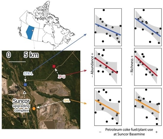
The statistical analyses were performed using the Elastic Net (EN) regularization technique and were performed using the ‘glmnet’ package in R [73]. All data were log10(x + 1) transformed and normalized (N(0,1)) to ease comparisons of coefficient magnitudes. Given the emphasis of regional monitoring in the OSR on detecting negative effects of industrial activity (e.g., [42]), the analysis focused on negative coefficients for the industrial variables (using the ‘upper.limits = 0’ argument in the glmnet() function in the glmnet package [73]), but placed no constraints on the MSP, MST, or MSWS predictors. Focus on negative (industrial) coefficients forced the EN algorithm to avoid positive coefficients even if these would improve the model fit. Although the ‘negative’ models were emphasized in this work, positively constrained and unconstrained ENs were also performed; the descriptive statistics of these additional ENs are provided in the Supplementary Information (Supplementary Tables S3 and S4). For all ENs, the α hyper-parameter was set to 0.5 and the minimum λ was selected using the cv.glmnet() function in the glmnet package [73]. Leave-one-out cross-validation was also used to examine the relationships between industrial and climate variables and BMIIs. The magnitude of the normalized coefficients and deviance ratios (DR) were used to evaluate the model fits. Additionally, Inverse Distance Weighting (IDW) was performed in QGIS with a distance coefficient of 2 to explore spatial patterns in the effect sizes (based on the magnitude of the EN regression coefficients) for the two most commonly selected industrial variables: SBM-FPU and SML-CBP. The purpose of the IDW analysis was to determine the spatial coherence of potential patterns of influence and the location of the SBM and SML facilities, respectively, on the BMIIs. This analysis included the information for all 68 site-BMII models.

3. Results

3.1. What Were the Most Commonly Selected Variables?

Among the analyses here, some of the initial hypotheses are supported, but the results also provide additional nuance on the health of benthic communities in the OSR. While null models were selected in 17 of the 68 site-index combinations (e.g., total abundance (TA) at STR-L), the most commonly identified variable among all of those examined, including both industrial and climatic variables was the fuel/plant use of petroleum coke at the Suncor Basemine (Table 1). Fuel/plant use of petroleum coke at Suncor (SBM-FPU) was identified in 25 of 68 (~37%) site-index combinations, such as TA and TR at the STR-L, JP-U, and SHL sites (Table 1 and Table 2). Among only industrial variables, the second most commonly selected factor was SML-CBP (~21%). The third most commonly identified industrial variable was KM-CBP (~13%), while the fourth most commonly selected variable was a tie between SML-FPU and MRM-CBP (~12%). The most commonly selected variable from in situ facilities, SMR-ST, was selected in three models (Table 1) and ALD was selected in seven models (~10%). Petroleum coke stockpiling at the three facilities where this occurs (SBM, SML, HM) was not commonly selected. The stockpiling of petroleum coke (PCS) at SML was identified in four site-index combinations while PCS at SBM and HM were each selected in two.
Among the four benthic macroinvertebrate indices (BMIIs), the influence of SBM-FPU was identified at 13 of 17 locations and SML-CBP was selected at 10 of 17 sites (Table 1). Among individual BMIIs, SBM-FPU was most commonly associated with TR. Among model results, EQ was associated with 21 different industrial variables, while TA was associated with 17, and TR and EPT were each associated with 16.
As expected, climatic variables were also commonly selected by the EN. Among the top five of all variables, MSP, MSWS, and MST were ranked second, third, and fourth, respectively (Table 1), suggesting the widespread influence of these variables throughout the OSR. Unlike the industrial variables, the selection of MSP, MST, and MSWS was not restricted to negative coefficients only and this likely contributed to their selection rates.

3.2. Industrial and Climatic Variables Selected at Primary Sites

Three primary locations closest to the SBM were selected in this study to examine the potential influence of industrial variables from this facility on benthic communities (Table 2). Among these three primary locations, STR-L, JP-U, and SHL, a null model (intercept only; DR = 0), was selected only once; the percent EPT at STR-L was not statistically associated with either natural or industrial variables examined in this study (Table 2). In contrast, all other BMII models from these sites selected by EN had at least one industrial or natural variable and the DRs ranged from 0.07 for EPT at SHL to 0.81 for TR at STR-L. Overall, the results suggest a low to moderate fit of models for some site/indices (e.g., TR at SHL (DR = 0.13) and TR at JP-U (DR = 0.31)), but better fits at STR-L for both TA (DR = 0.69) and EQ (DR = 0.65).
Among the industrial variables, SBM-FPU was selected in 7 of 12 site-BMII combinations tested at the three primary sites (Table 2) reflecting a similar pattern among all site-index models (Table 1). At the STR-L site the influence of SBM-FPU was apparent in TA, TR, and EQ. While the DRs for the full models were smaller than at STR-L, SBM-FPU was also associated with declines in TA and TR and JP-U and SHL. Among TA and TR at JP-U, SBM-FPU was the only industrial variable selected and had a low to moderate influence on the DR. More commonly, multiple industrial predictors were selected. Where more than one industrial variable was selected, the SBM-FPU had the largest effect on TA and TR at STR-L, and TR at SHL. In contrast, SBM-FPU had the smallest effect on EQ at STR-L and TA at SHL (although in the latter case, SBM-FPU was one of only two industrial variables selected by the EN).
Other industrial variables were also selected at the three primary sites. Crude bitumen production (CBP) at SBM, SML, and KM were associated with declines in TA at STR-L while CBP at SAN was associated with declines of TR at STR-L and, although weakly, with EPT at SHL (Table 2). CBP at SML was also associated with declines in EQ at STR-L, and TA and TR at SHL. While CBP at other mines were also associated with BMIIs, such as an influence of JPM-CBP on EQ at STR-L, JP-U, and SHL (and had the largest industrial effects at each site) and KM-CBP was also associated with declines of EQ at JP-U and SHL, there was also potential influence of HM-PCS on EQ at STR-L and SML-PCS on EQ at JP-U and SHL. However, the influences of SML-PCS on EQ at the JP-U and SHL sites and HM-PCS on EQ of benthos at STR-L were the second smallest effects and the effect sizes ranged from 3.7 to 43 times smaller than the industrial variable with the largest influence. Steam injection at the Suncor Firebag in situ facility (SFB-ST) was also identified by EN in the model for EQ at JP-U, but the effect was ~10× smaller than the influence of the industrial predictor with the largest effect, JPM-CBP.
While climatic variables were also commonly selected at these sites (e.g., MST was the only variable selected in EPT at JP-U) and some of these variables had large effects (MSP on TA at STR-L; Table 2), in sum, these data suggest diverse sources may potentially influence locations, including facilities both adjacent to study sites, but also more remote facilities. The data show associations of benthos with facilities which are either not in an upstream area or within ~10 km of sites, and no influence of ALD was identified at these locations. The results also suggest the influence from potential sources may degrade rapidly with space as demonstrated by declines in the DRs in TR from STR-L, SHL, and JP-U.

3.3. Industrial and Climatic Variables Selected at Secondary Sites

Among the secondary stream locations selected for examination, STR-U and JP-L, the exposure scenarios compared to the corresponding primary sites are opposite. In Jackpine Creek, proximity to industrial facilities increases at JP-L compared to JP-U, whereas in the Steepbank, STR-U is farther from industrial facilities than STR-L and there were potential associations with industrial variables at the JP-L and STR-U sites which may reflect these changes in use of the surrounding land (Table 3). In contrast to the STR-L location, potential influences were only identified in TR at STR-U location; the remaining BMII models at STR-U were fit as intercept only, null models. In contrast, no null models were fit at the JP-L location (Table 3). Among the non-null models at both secondary sites, the DR ranged from 0.15 for TR at JP-L to 0.85 for TR at STR-U.
In four of five non-null models from the secondary sites, SBM-FPU was selected by the EN. At three of these locations, SBM-FPU had the largest effect among the selected industrial variables, but had the smallest effect at the fourth (Table 3). For the fifth non-null BMII model, EQ at JP-L, PCP, SCP, and CBP at SBM were identified by EN. Among these SBM variables selected for EQ at JP-L, PCP had the largest effect. Influence of other oil sands facilities were also identified by EN at the secondary sites. These include an influence of MRM-CBP on TR at STR-U and TA at JP-L, JPM-CBP on TR at STR-U, SML-CBP on EPT at JP-L, and KM-CBP on EQ at JP-L, suggesting, similar to the primary sites, that the zones of influence from some facilities may be spatially broad. However, in contrast to the primary locations, ALD was identified by the EN at STR-U (TR) suggesting the potential influence of local activity. Similarly, potential influences of ALD were apparent in BMIIs at JP-L (EQ), but MRM-CBP may have also affected TA of BMIs at this site. The MRM project boundary is partially within the JP-L watershed area suggesting the potential influence of one facility through multiple physical pathways. The potential influences of MST, MSP, or MSWS were also apparent in at least one BMII at STR-U and JP-L.
Other patterns were also apparent when comparing the primary and secondary sites within the Jackpine Creek and Steepbank River. Mean summer precipitation (MSP) and SBM-FPU were both selected for TR at STR-U and STR-L (Table 2 and Table 3). There were also relationships of BMIIs at the STR-U and STR-L location with CBP at facilities in the Muskeg drainage (KM, MRM, JPM), although the specific facilities differed (Table 2 and Table 3). Similarly, SBM-FPU and MSP were also both selected by EN for TA at JP-U and JP-L. An influence of KM-CBP on EQ was also selected at both of the Jackpine Creek sites. Although these spatial patterns suggest some consistency among some industrial variables within watersheds, differences in drivers between sites within a watershed were also identified.

3.4. Spatial Patterns of Industrial Influences

In addition to some of the spatial pattens described already, such as the common occurrence of SBM-FPU at the primary and secondary sites, these and other patterns were also apparent at the remaining sites examined in this study. While influences of MST, MSP, and MSWS were commonly associated with BMIIs at all sites (Supplementary Tables S5 and S6), the data suggest both evidence of expected exposure relationships between facilities and sampling locations, including potential long-range transport of CoCs. Among the two most commonly selected industrial variables, spatial patterns were examined using Inverse Distance Weighting (IDW; Figure 2). The spatial patterns of SBM-FPU and SML-CBP identified by IDW correspond spatially with the SBM and SML mines, respectively. However, the broader influence of SBM-FPU is apparent, along with some local elevation in areas close to and extending from the SBM. While the influence of SML-CBP is typically more localized around SML, there is also potential influence of this industrial variable to the north and east margins of the study area. The degree of influence of SBM-FPU is also roughly 2× greater than the maximum influence of SML-CBP.
Regional influences of both SML and SBM, for example, were also apparent throughout the region coupled with influences which both suggested proximate and remote influences of facilities. For example, at the Ells River locations (ELR-L and ELR-U), three BMIIs were associated with SBM, two with MRM, and one with KM, also suggesting the potential influence of local and regional factors via the atmosphere (none of these mines are within the watersheds of either Ells locations) but also the potential complexity of industrial descriptors and a lack of influence of the selected variables; three of the eight BMIIs examined in the Ells River were fit with null models (Supplementary Table S6). Additionally, at MCL, KEL, and FB-U sites, only two industrial variables selected across all BMIIs (ALD on TA and TR at FB-U and CBP at JPM on EQ at FB-U) were not associated with either SBM or SML (Supplementary Table S5). However, at the FB-L location, the EN suggested relationships between fewer variables from SBM and SML, but identified a potential influence of KM-CBP which is partially sited in the FB-L drainage. These observations are consistent with the potential interaction of both local and regional sources and expected sources over space likely transported from the emission point through the atmosphere, but also indicate that influences of industrial and climatic variables are not always apparent in benthic invertebrates.
Other indications of industrial influence far from locations was also apparent in the additional stream and lake sites. Along with the potential influence of PCS at the HM on declines in EQ at the STR-L location (although the coefficient was the second smallest among industrial variables at this location, but was higher than SBM-FPU (Table 2)), there was a potential association of steam injection (ST) at Suncor MacKay River (SMR) with EQ at ISL and no other industrial variable (Supplementary Table S5). In contrast, EPT at ISL was associated with SBM-FPU and SML-FPU and SML-PCP (Supplementary Table S5). Fuel/plant use of petcoke (FPU) and petcoke production (PCP) at SML were also associated with TR at ISL, but so were CBP, PCP, and SCP at the HM (Supplementary Table S5). Despite the occurrence of influence, in many cases, the coefficients at ISL were small, such as the influence of HM-CBP on TR, although collectively the DRs could also be variable.
Similar to some evidence from the JP-L location described above, other data from sites in the Muskeg Basin also suggest variable selection by EN may identify multiple mechanisms of influence from a given facility. While ALD was selected by EN for TR at the MUR-M location, the influence of MRM-CBP and SAN-CBP (both within the upslope area of the MUR-M location) were also both selected (Supplementary Table S5). Similarly, both ALD and KM-CBP were each selected by EN for EQ at MUR-U, although the influence of ALD was 60 times smaller than the influence of KM-CBP. In contrast, the influence of CBP at MRM and CBP at SAN were also selected by EN for the TA model at MUR-M, but ALD was not (Supplementary Table S5). Annual land disturbance (ALD) was also identified by EN in TA at MUR-L without an accompanying influence of facilities operating in the Muskeg Basin. This result potentially suggests the ALD metric in the Muskeg Basin may capture industrial influence; ALD at MUR-L had the largest effect size among industrial variables, but was accompanied by influence of SBM-FPU (Supplementary Table S5). However, an effect of activity at industrial facilities in the Muskeg Basin was not absent at MUR-L; lower EQ with KM-CBP was observed, suggesting the potential for both local and regional influence, although both the coefficient and the model DR were small. Collectively, these data suggest that while effects of local facilities may also emerge when those facilities occur in the upslope area of a given location, such as the JPM and JP-L and MRM and MUR-M, proximity may not always be the best predictor of industrial influence.
Responses of benthos collected at the two sites in the MacKay Basin, MAC-M and MAC-L, also did not unambiguously demonstrate the potential utility of proximity to an industrial facility. While there were small potential influences of steam injection and bitumen production at the SMR in situ facility on TA at the MAC-M location, the largest potential influences on BMIIs at this site were roughly equal effects of SBM-FPU and SML-CBP (Supplementary Table S6). The potential influence of these industrial variables on TA of benthos at the MAC-M location were also accompanied by FPU and PCP at SML and small influences of CBP and SCP at Horizon, MRM-CBP, and SMR-B (Supplementary Table S6). While varying in size, there were also indications of influence from mines in the Muskeg River Basin, KM, JPM, and MRM, on BMIs at MAC-M. In contrast to MAC-M, few industrial variables were selected for the BMII models at the MAC-L site. Consistent with relationships between industrial facilities and benthos locations based on spatial proximity, SML-FPU was associated with declines of TA at the MAC-L site, but inconsistently, an influence of SFB-B on TA was also identified by EN at this location. Although SBM-FPU was also selected for EQ at MAC-L, the effect was small (DR < 0.01), but other DRs in the MacKay River were large (0.93 for TA at MAC-M).

3.5. Potential Influence of Climatic and Land Disturbance Variables

Although some were described above, the selection of CLD, ALD, MSP, MST, and MSWS also deserve some specific highlighting, including co-occurrence among themselves and with other industrial variables. Among these variables, MSWS and MST were identified as the sole variables in three and two models, respectively (Table 2 and Table 3, and Supplementary Tables S3 and S4). Mean summer wind speed (MSWS) was selected by EN in 20 models and co-occurred with SML-FPU 7 times, SBM-FPU 10 times, MSP 11 times, and MST 8 times. Among models incorporating MST, 11 of 19 also identified SBM-FPU and 7 of 19 identified SML-CBP. Mean summer precipitation was not selected in any models as a sole predictor, but was associated with SBM-FPU in 16 of 23 instances. Similarly, ALD was not selected in any model as a singular variable, but in the seven instances it was identified, MSP occurred in five models and SBM-FPU was identified in six. These data suggest interactions may be occurring among climatic variables and among climatic variables and descriptors of industrial activity.

4. Discussion

Among studies performed in the OSR, many have identified chemical influences within ~25 km of the Suncor Basemine and Syncrude Mildred Lake upgrading facilities [7,22,23,28]. While accompanied by the influence from other sources, stack emissions and dusts are often highlighted as the major sources of CoCs in the environment in analyses of both contemporary [10,11,20,23] and historical data sets [7,22]. While also suggesting mines have a greater influence on CoCs compared to in situ facilities [8], recent work suggests a greater role of specific activities at some facilities compared to others on the deposition of PACs and V in snow, such as petroleum coke combustion compared to its stockpiling [8]. While no other variables were evaluated, that earlier work also suggested a potential influence of the combustion of petroleum coke at the Suncor Basemine on the health of slimy sculpin residing in the Steepbank River [8]. The results here also suggest detectable influences of industrial activities on benthic macroinvertebrates at sites within and adjacent to the minable region, but also support the use of variable selection tools, such as the EN.
In alignment with, but more specific than much of the previous work [7,8,10,11,21,22,23,74,75], the analyses presented here suggests a common influence of FPU at the Suncor Basemine on benthic invertebrates in the OSR. Mechanistically, the common regional associations between BMIIs and SBM-FPU may be associated with the emission and deposition of metal-laden petcoke fly ash originating from Suncor’s coke-fired power plant [6,13,14,15]. Combustion of petroleum coke is often associated with emissions of metals [76] and likely drove the particulate loading apparent in the OSR in the 1970s until an electrostatic precipitator (ESP) began operating in November 1979 [5,77]. While the drop in particulate emissions after the installation of the ESP at SBM has been documented in lake sediments and in snow [7,10], a discernible influence of the combustion of petroleum coke likely remains in snow samples collected between 2011 and 2016 [8]. Although larger particles are present in the summer suggesting contributions from dust [17,18,19,78], the size distributions of particles in snow [79,80], the particle sizes and chemical composition of petcoke fly ashes [13,14,15,81], the efficiency of generic ESPs [82], and size distributions of particles emitted from stacks [27] suggest the influence of petroleum coke combustion on the deposition of some CoCs in the OSR. Based on the results here, many studies detecting changes in the deposition of CoCs may be identifying petroleum coke fly ash from Suncor’s coke-fired power plant [7,10,11,20,22,23,33,75,83,84] which, via the component CoCs [85,86], may also be influencing benthic communities in the OSR.
Although SBM-FPU was commonly identified, the analyses are exploratory (and retrospective) and the result remains hypothetical and not conclusive [30,87]. However, Suncor is in the process of replacing its coke-fueled boilers with natural gas co-generation equipment [88]. Similar to the expected reductions in emissions of CoCs such as SOx and reduced water use [88], the results here further suggest this upgrade may lead to improved environmental conditions in the OSR. In contrast, other researchers suggest the replacement of the coke-fueled boilers at the Suncor Basemine scheduled for 2024 will exacerbate the contamination of the local environment if the delayed petcoke is no longer used as a fuel, accumulates on the Suncor site a greater rate, and is dispersed throughout the region by the wind [20]. The results of this analysis suggest the mass of stored petcoke at HM, SML, and SBM are not widely influential although petcoke dust dislodged by wind is likely present in areas beyond the stockpiles [8,9]. However, the patterns of deposition and likely sources can vary by study medium and potentially season [11,18,19,21,22,78,89] and the mass of stored petcoke is one of many potentially relevant factors determining the wind erosion of stockpiled material [90,91,92,93]. Additionally, an effect of wind-blown dusts on benthic invertebrates may be better associated with MSWS than with industrial variables, such as the mass of stored petroleum coke. Although there is likely further nuance related to phase, season, and compounds affecting dispersal of CoCs [75], including potential emissions of petcoke particles from stacks [15], the competing hypotheses can be evaluated using data collected before and after Suncor Basemine undergoes the planned upgrade [8].
This work identified influences on benthic communities which are consistent with some published findings, but inconsistent with others. Lake sediment studies have shown chemical evidence likely associated with regional and local sources [7,8,22], but found little evidence of an effect of industry in planktonic communities [22,94]. Other work suggests there may be industrial influence on benthic communities in some lakes, but the results were not conclusive [45]. Additionally, while some studies in streams suggest changes have occurred over time [55,56], other research did not find clear associations between industrial activity and the chemical and biological status of streams [8,34,39,40,41,50,95,96,97,98]. Despite the plausibility of multiple exposure pathways and potential risk in aquatic environments [99,100], the contrast between the work presented here and the results of previous research requires explanation. One possible explanation is that industrial influences in some environments may be small, requiring large sample sizes to detect, e.g., [101]. For example, signals associated with emissions and deposition of sub-micron microcrystals of petcoke fly ash, despite their proportional enrichment of contaminants, such as V, Ni, and Ti [13,14,15], may be masked in water quality surveys by larger, naturally occurring particles with greater proportional mass contributions to the concentrations of these elements in water samples [39,40,41]. While other natural phenomena may also impede the detection of industrial signals, e.g., [98], intensity of industrial activities associated with the release of CoCs may overcome this potential masking and may be used to identify both regional and local impacts of facilities in other studies [16,17,18,19,74,102,103,104], assuming transport mechanics are consistent over time.
Industrial activities in the OSR likely affect the ambient environment via multiple effect pathways [3] and this was likely reflected in this analysis. The results of the current analysis strongly support the importance of atmospheric deposition of CoCs as a primary exposure pathway in the OSR [3] and beyond, e.g., [24,105]. While stack emissions estimated by SBM-FPU and SML-FPU may influence benthic communities, contributions from other atmospheric pathways may also be captured by the industrial metrics, such as CBP and SCP, including particulate or gaseous emissions from mine fleets, mine faces, and tailings ponds [106,107,108], suggesting the industrial metrics used here are complex surrogates of industrial activity. The inferred influence of industrial activity via atmospheric deposition was, however, also likely accompanied by local effects associated with land disturbance. While common in the terrestrial literature [35], few studies examine the influence of this stressor on surface waters, e.g., [46,56,109], and at some locations, such as JP-L, land disturbance may also reflect occasional release of discharge waters [42]. While this work focused on identifying negative effects of industrial coefficients, unconstrained ENs suggest other possible effects of industry. For example, CLD was selected in 13 models in an EN restricted to positive coefficients (Supplementary Table S3) compared to only once in the negative-only ENs (Table 1). While the focus of this work was on identifying negative relationships, there may be some utility in broader searches for explanatory factors using unbounded ENs (Supplementary Table S4). Future analyses may also benefit from a more thorough understanding of the relationships between the industrial surrogates and chemical and biological effects and of the differences in activities among facilities.
The results of this research may have implications for the design of regional monitoring in the OSR and analyses of the data. First, the work here suggests facility-level performance may be a potent source of information on environmental influence from the industry and that future work may need to incorporate these data, e.g., [110]. Second, monitoring stations in the OSR are often selected based on their proximity and/or location downstream of oil sands facilities [42], but the analyses here and elsewhere [18,19,75] suggest a combination of both local and regional stressors may affect benthic invertebrates residing in streams and lakes [6,13,14,15,106,107,108,111,112]. Consequently, analyses based on activity at adjacent facilities may not encapsulate the factors driving local variability and additional work may need to account for differing exposure pathways among habitats [7,8,10,11,21,75,94,113,114,115]. The need to undertake detailed studies to attribute variability may not be necessary where comparisons to CESs currently suggest good ecological conditions or little evidence of impairment [42,45,48], but are likely important where the risk remains. If identifying and tracking industrial influence is required, the analyses also suggest potential opportunities to examine existing data sets, such as fish and water quality, e.g., [64]. Parallel studies, or the modification and augmentation of sampling designs, can also be conducted to further probe the hypotheses generated by this work and may be beneficial for developing regional (and integrated) monitoring protocols in the OSR [65].
If additional analyses are conducted, care may also be needed to characterize climatic and natural stresses. While MST and MSP were included here to account for background variation, other factors such as stream discharge may further explain some of the differences over time [58,59,64,101]. While better characterizing natural exposures would be beneficial, some, such as discharge in OSR tributaries, may be influenced by industrial activity, e.g., [46,56]. Consequently, defining factors such as stream discharge as representing ‘natural conditions’ may, in some instances, not be accurate [59]. This may also be true of the influence of precipitation and subsequent runoff to waterbodies in the OSR [46,59]. However, future work may also benefit from including other descriptors, such as wind gusts [116] or, depending on the goals and the need for interpretability, incorporate many other possible predictors.
While effects of industrial activity are apparent from these analyses, some null models were selected by the EN. The selection of null models may be affected by limiting the results of most variables to negative coefficients and potential under-powering of analyses at some sites, such as FB-U. The selection of null models also generally suggests there were no correlations between predictors and BMIIs, but specifically suggests no substantive or assignable changes were occurring at these locations, none of the industrial factors were influencing the benthic indices, other climatic covariates were interfering with industrial effects, or more complex multiplicative effects of many variables were occurring. While many factors were included, an exhaustive search to include all potential factors and their interactions in the statistical analysis was not carried out here and may be pursued in future work. Including more variables may resolve potential challenges with petroleum coke dust emissions where mass is one of many potentially relevant factors determining the suspension and dispersal of stockpiled material by wind [90,91,92,93]. If more variables are included, the EN is well-equipped to address the challenges of variable selection, collinearity and variable grouping, and p >> n [63]. While including more terms, such as interactions may also contribute to the challenges of identifying change in the OSR and is likely beneficial for prediction, it can also increase model complexity and reduce interpretability.
Some industrial or climatic variables may also have been mis-fit to the BMIIs or be otherwise affected by an Omitted Variable Bias (OVB) [62]. For example, some benthic endpoints at sites far from potential sources were identified by the EN, such as the influence of PCS at Horizon on EQ of BMI at STR-L or potential effects of operations at SML and SBM on benthos collected at the FB-U site. However, long-range transport is also a plausible mechanism explaining the influence of industrial variables on benthos at some locations. Similarly, mis-fitting may also explain the common selection of CBP at JPM and MRM. The MRM and JPM facilities began mining and processing bitumen in December 2002 and August 2010, respectively [69,70] and began rapidly increasing production rates (Supplementary Figure S5). In contrast, SAN also began mining at roughly the same time (March 2001), it was only identified in 4 of 68 models and its rate of production increases were more gradual than at JPM and MRM (Supplementary Figure S5). The production patterns at MRM and JPM may be proxies for other activities in the region, including the more general increases in production at all mines or all in situ facilities (Supplementary Figure S6), or population growth [57]. Although there are some challenges in the interpretation of some of these data, follow-up work can be done using existing datasets to examine the veracity of the industrial and climatic influences suggested in this study.
Other patterns were also apparent from these data. For example, TR and TA at the STR-L site increased over time (Supplementary Figures S1 and S2). These data suggest ecological conditions in the most exposed areas may have improved. Similar observations are also consistent with ecological improvements, including greater numbers and size of spawning white sucker (Catostomus commersonii) and walleye (Sander vitreus) between 2006 and 2014 [57], record numbers of spawning white sucker in 2009 [56], increased primary productivity [22,94] and no indications of toxic effects in zooplankton [22]. Some of these improvements may be driven by climate [94], but there may also be nutrifying effects of emissions from stacks [117], although neither the evidence from the current work using ENs constrained to negative coefficients nor other research [94] fully supports this mechanism. However, parallel ENs limited to positive coefficients (Supplementary Table S3) suggest SML-FPU may be associated with increases in the BMIIs at some regional locations. Contrasting with previous work [94], an effect of SML-FPU may be associated with greater emissions of nitrogenous compounds from Syncrude compared to Suncor estimated from samples collected in August 2008 [27]. However, unconstrained ENs (Supplementary Table S4) also suggest a mixture of positive and negative effects and generally represent the best model fits. Further examining these additional results is likely necessary in future work. Importantly, however, the EN may be a useful and powerful tool for identifying and tracking industrial influences in both future analyses of benthic invertebrates and other indicators of industrial influence in the OSR and potentially in other monitoring programs.

5. Conclusions

While the patterns of chemical influence of OSIA have largely been generally established and physical alterations are easily observed, identifying associations between industrial activity and the status of biological indicators in aquatic ecosystems in the OSR has been historically challenging [34,39,40,41,51,52,95,97]. Despite this challenge, some data based on site-specific analyses suggest the potential influence of site preparation and construction on indicators of water quality [55] and unknown influences on spawning populations [56]. The analyses conducted here and elsewhere, e.g., [8], further suggest site-specific analyses coupled with facility-level data may identify discernible influences of industrial activity not identified in previous work. Using the EN, the analyses most notably identified the potential influence of the emissions and deposition of delayed coke fly ash on benthic communities at multiple sites throughout in the OSR, including locations close to the main stack of Suncor’s coke-fired power plant. Additionally, the stockpiling of petroleum coke, land disturbance, production at multiple facilities, and effects of climatic factors were also apparent to varying degrees. These analyses suggest facility data may be used as covariates to identify and track environmental change [30], but that the influence of climate can also be incorporated, e.g., [34]. Future analyses of this type, including more recent data from the regional monitoring or integrating data from additional facilities, may improve regional monitoring and may be useful for tracking future conditions below any stipulated critical effect sizes. Specifically, the potential influence of SBM-FPU can be tested using data collected before and after decommissioning the coke-fueled boilers at the Suncor Basemine. Finally, these analyses, along with other work [64], suggest the EN may be a powerful addition to examining results of regional monitoring data in Canada’s OSR and beyond.

Supplementary Materials

The following are available online at https://www.mdpi.com/article/10.3390/environments8110123/s1, Table S1: Cumulative land disturbances (%) for stream sites; calculated from ABMI 2018; STR = Steepbank River; JP = Jackpine Creek; MUR = Muskeg River; FB = Firebag River; ELR = Ells River; MAC = MacKay River; SHP = Shipyard Lake; ISL = Isadore’s Lake; MCL = McClelland Lake; L = Lower; U = Upper; M = Middle; locations and watersheds shown in Figure S1; proportion of land disturbance (ALD) calculated as difference per year. Table S2: Cumulative land disturbance (%) for the four study lakes per study year; proportion of land disturbance (ALD) calculated as difference per year; locations and watersheds shown in Figure S1. Table S3: Selection rates, ranks, counts per BMI index, and number of sites with a selected variable of industrial and climatic variables returned by EN using a lower limit of zero (0) for industrial variables and no constraints for MSP, MST, and MSWS; TA = total abundance; TR = taxon richness; EPT = percent EPT; EQ = equitability; NA = not applicable; 19 models were intercept only; variable codes defined in main article body (see Section 2.2). Table S4: Selection rates, ranks, counts per BMI index, and number of sites with a selected variable of industrial and climatic variables returned by EN with no constraints for any variables MSP, MST, and MSWS; TA = total abundance; TR = taxon richness; EPT = percent EPT; EQ = equitability; NA = not applicable; 15 models were intercept only; variable codes defined in main article body (see Section 2.2). Table S5: Results of Elastic Net variable selection for additional sites east of the Athabasca River; variable codes defined in main article body (see Section 2.2); locations shown in Figure S1; TA = total abundance; TR = taxon richness; EPT = percent EPT; EQ = equitability. Table S6: Results of Elastic Net variable selection for additional sites east of the Athabasca River; variable codes defined in main article body (see Section 2.2); locations shown in Figure S1; TA = total abundance; TR = taxon richness; EPT = percent EPT; EQ = equitability). Figure S1: Total abundance of benthic macroinvertebrates from RAMP. Figure S2: Taxon richness of benthic macroinvertebrates from RAMP. Figure S3: Percent EPT of benthic macroinvertebrates data from RAMP. Figure S4: Equitability of benthic macroinvertebrates from RAMP. Figure S5: Selectable industry (and ‘climatic’ (MSP, MST, MSWS)) variables obtained for EN; values standardized to minimum and maximum values per variable (minimum = 0; maximum = 1); MST = mean summer temperature; MSP = mean summer precipitation; MSWS = mean summer wind speed; Suncor Basemine = SBM, Syncrude Mildred Lake = SML, Horizon Mine = HM, Syncrude Aurora North = SAN, Muskeg River Mine = MRM, Jackpine Mine = JPM, Kearl Mine = KM, Suncor Firebag in situ = SFB, and Suncor MacKay River in situ = SMR; fuel/plant use of petroleum coke = FPU, petroleum coke production = PCP, closing inventory of petcoke stockpiles = PCS, crude bitumen production = CBP, synthetic crude production = SCP; bitumen production = B; steam injection = ST. Figure S6: Mining and in situ production (thousands of barrels per day) over time; data obtained from www.oilsandsmagazine.com (accessed on 5 October 2021).

Funding

Funding for this work was provided by the Oil Sands Monitoring Program.

Institutional Review Board Statement

No collection permits were required in the Province of Alberta for aquatic benthic macroinvertebrates when the samples used in this study were collected and ethical review and approval were waived for this study.

Data Availability Statement

This study used only publicly available data. Data sources were the Alberta Energy Regulator (https://www.aer.ca/providing-information/data-and-reports/statistical-reports/st39 and https://www.aer.ca/providing-information/data-and-reports/statistical-reports/st53), the Regional Aquatics Monitoring Program (http://www.ramp-alberta.org/ramp/data.aspx), Environment and Climate Change Canada Weather Office (https://weather.gc.ca/), the Wood Buffalo Environmental Association (https://wbea.org/), and the Alberta Biodiversity Monitoring Institute (https://www.abmi.ca/home/data-analytics/da-top/da-product-overview/Human-Footprint-Products/HF-inventory.html). All the data sources were accessed on 5 October 2021.

Acknowledgments

The author thanks Bruce Kilgour for providing the processed RAMP benthos data and the Alberta Energy Regulator for providing historical ST39 and ST53 reports. This work was supported by the Oil Sands Monitoring program but the article does not necessarily reflect an official position of The Program or Alberta Environment and Parks. The author also appreciates the comments and time of internal and external reviewers.

Conflicts of Interest

The author declares no conflict of interest. The funders had no role in the design of the study, in the collection, analyses, or interpretation of data, in the writing of the manuscript, or in the decision to publish the results.

References

  1. Carpenter, S.R.; Stanley, E.H.; Vander Zanden, M.J. State of the world’s freshwater ecosystems: Physical, chemical, and biological changes. Annu. Rev. Environ. Resour. 2011, 36, 75–99. [Google Scholar] [CrossRef] [Green Version]
  2. Ormerod, S.J.; Dobson, M.; Hildrew, A.G.; Townsend, C.R. Multiple stressors in freshwater ecosystems. Freshw. Biol. 2010, 55, 1–4. [Google Scholar] [CrossRef]
  3. Roberts, D.R.; Hazewinkel, R.O.; Arciszewski, T.J.; Beausoleil, D.; Davidson, C.J.; Horb, E.C.; Sayanda, D.; Wentworth, G.R.; Wyatt, F.; Dubé, M.G. An integrated knowledge synthesis of regional ambient monitoring in Canada’s oil sands. Integr. Environ. Assess. Manag. 2021, in press. [Google Scholar] [CrossRef]
  4. Horb, E.C.; Wentworth, G.R.; Makar, P.A.; Liggio, J.; Hayden, K.; Boutzis, E.I.; Beausoleil, D.L.; Hazewinkel, R.O.; Mahaffey, A.C.; Sayanda, D. A decadal synthesis of atmospheric emissions, ambient air quality, and deposition in the oil sands region. Integr. Environ. Assess. Manag. 2021, in press. [Google Scholar] [CrossRef] [PubMed]
  5. Murray, W.A. The 1981 Snowpack Survey in the AOSERP Study Area; Alberta Oil Sands Environmental Research Program: Edmonton, AB, Canada, 1981. [Google Scholar] [CrossRef]
  6. Shelfentook, W. An Inventory System for Atmospheric Emissions in the AOSERP Study Area; Alberta Oil Sands Environmental Research Program: Edmonton, AB, Canada, 1978. [Google Scholar] [CrossRef]
  7. Cooke, C.A.; Kirk, J.L.; Muir, D.C.G.; Wiklund, J.A.; Wang, X.; Gleason, A.; Evans, M.S. Spatial and temporal patterns in trace element deposition to lakes in the Athabasca oil sands region (Alberta, Canada). Environ. Res. Lett. 2017, 12, 124001. [Google Scholar] [CrossRef]
  8. Arciszewski, T.J.; Hazewinkel, R.R.O.; Dubé, M.G. A critical review of the ecological status of lakes and rivers from Canada’s Oil Sands Region. Integr. Environ. Assess. Manag. 2021, in press. [Google Scholar] [CrossRef] [PubMed]
  9. Zhang, Y.; Shotyk, W.; Zaccone, C.; Noernberg, T.; Pelletier, R.; Bicalho, B.; Froese, D.G.; Davies, L.; Martin, J.W. Airborne Petcoke Dust is a Major Source of Polycyclic Aromatic Hydrocarbons in the Athabasca Oil Sands Region. Environ. Sci. Technol. 2016, 50, 1711–1720. [Google Scholar] [CrossRef]
  10. Gopalapillai, Y.; Kirk, J.L.; Landis, M.S.; Muir, D.C.G.; Cooke, C.A.; Gleason, A.; Ho, A.; Kelly, E.; Schindler, D.; Wang, X.; et al. Source Analysis of Pollutant Elements in Winter Air Deposition in the Athabasca Oil Sands Region: A Temporal and Spatial Study. ACS Earth Space Chem. 2019, 3, 1656–1668. [Google Scholar] [CrossRef]
  11. Chibwe, L.; Muir, D.C.G.; Gopalapillai, Y.; Shang, D.; Kirk, J.L.; Manzano, C.A.; Atkinson, B.; Wang, X.; Teixeira, C. Long-term spatial and temporal trends, and source apportionment of polycyclic aromatic compounds in the Athabasca Oil Sands Region. Environ. Pollut. 2021, 268, 115351. [Google Scholar] [CrossRef]
  12. Klemt, W.H.; Kay, M.L.; Wiklund, J.A.; Wolfe, B.B.; Hall, R.I. Assessment of vanadium and nickel enrichment in Lower Athabasca River floodplain lake sediment within the Athabasca Oil Sands Region (Canada). Environ. Pollut. 2020, 265, 114920. [Google Scholar] [CrossRef] [PubMed]
  13. Jang, H. Characterization of Oil Sands Fly Ash. Master’s Thesis, University of Alberta, Edmonton, AB, Canada, 2004. [Google Scholar]
  14. Holloway, P.C. Vanadium Recovery from Oil Sands Fly Ash. Master’s Thesis, University of Alberta, Edmonton, AB, Canada, 2003. [Google Scholar]
  15. Gomez Bueno, C.O.; Rempel, G.L.; Spink, D.R. Physical and Chemical Characterization of Athabasca Tar Sands Fly Ash. CIM Bull. 1980, 73, 147–151. [Google Scholar]
  16. Stachiw, S.; Bicalho, B.; Grant-Weaver, I.; Noernberg, T.; Shotyk, W. Trace elements in berries collected near upgraders and open pit mines in the Athabasca Bituminous Sands Region (ABSR): Distinguishing atmospheric dust deposition from plant uptake. Sci. Total Environ. 2019, 670, 849–864. [Google Scholar] [CrossRef]
  17. Shotyk, W.; Bicalho, B.; Cuss, C.W.; Duke, M.J.M.; Noernberg, T.; Pelletier, R.; Steinnes, E.; Zaccone, C. Dust is the dominant source of “heavy metals” to peat moss (Sphagnum fuscum) in the bogs of the Athabasca Bituminous Sands region of northern Alberta. Environ. Int. 2016, 92, 494–506. [Google Scholar] [CrossRef]
  18. Phillips-Smith, C.; Jeong, C.H.; Healy, R.M.; Dabek-Zlotorzynska, E.; Celo, V.; Brook, J.R.; Evans, G. Sources of particulate matter components in the Athabasca oil sands region: Investigation through a comparison of trace element measurement methodologies. Atmos. Chem. Phys. 2017, 17, 9435–9449. [Google Scholar] [CrossRef] [Green Version]
  19. Mamun, A.A.; Celo, V.; Dabek-Zlotorzynska, E.; Charland, J.P.; Cheng, I.; Zhang, L. Characterization and source apportionment of airborne particulate elements in the Athabasca oil sands region. Sci. Total Environ. 2021, 788, 147748. [Google Scholar] [CrossRef] [PubMed]
  20. Ahad, J.M.E.; Pakdel, H.; Labarre, T.; Cooke, C.A.; Gammon, P.R.; Savard, M.M. Isotopic Analyses Fingerprint Sources of Polycyclic Aromatic Compound-Bearing Dust in Athabasca Oil Sands Region Snowpack. Environ. Sci. Technol. 2021, 55, 5887–5897. [Google Scholar] [CrossRef]
  21. Manzano, C.A.; Muir, D.; Kirk, J.; Teixeira, C.; Siu, M.; Wang, X.; Charland, J.P.; Schindler, D.; Kelly, E.; Zhang, Y.F. Temporal variation in the deposition of polycyclic aromatic compounds in snow in the Athabasca Oil Sands area of Alberta. Environ. Monit. Assess. 2016, 188, 542. [Google Scholar] [CrossRef]
  22. Kurek, J.; Kirk, J.L.; Muir, D.C.G.G.; Wang, X.; Evans, M.S.; Smol, J.P. Legacy of a half century of Athabasca oil sands development recorded by lake ecosystems. Proc. Natl. Acad. Sci. USA 2013, 110, 1761–1766. [Google Scholar] [CrossRef] [PubMed] [Green Version]
  23. Landis, M.S.; Studabaker, W.B.; Patrick Pancras, J.; Graney, J.R.; Puckett, K.; White, E.M.; Edgerton, E.S. Source apportionment of an epiphytic lichen biomonitor to elucidate the sources and spatial distribution of polycyclic aromatic hydrocarbons in the Athabasca Oil Sands Region, Alberta, Canada. Sci. Total Environ. 2019, 654, 1241–1257. [Google Scholar] [CrossRef] [PubMed]
  24. Liggio, J.; Li, S.M.; Hayden, K.; Taha, Y.M.; Stroud, C.; Darlington, A.; Drollette, B.D.; Gordon, M.; Lee, P.; Liu, P.; et al. Oil sands operations as a large source of secondary organic aerosols. Nature 2016, 534, 91–94. [Google Scholar] [CrossRef]
  25. Landis, M.S.; Studabaker, W.B.; Pancras, J.P.; Graney, J.R.; White, E.M.; Edgerton, E.S. Source apportionment of ambient fine and coarse particulate matter polycyclic aromatic hydrocarbons at the Bertha Ganter-Fort McKay community site in the Oil Sands Region of Alberta, Canada. Sci. Total Environ. 2019, 666, 540–558. [Google Scholar] [CrossRef]
  26. Landis, M.S.; Pancras, J.P.; Graney, J.R.; Stevens, R.K.; Percy, K.E.; Krupa, S. Receptor Modeling of Epiphytic Lichens to Elucidate the Sources and Spatial Distribution of Inorganic Air Pollution in the Athabasca Oil Sands Region. Dev. Environ. Sci. 2012, 11, 427–467. [Google Scholar] [CrossRef]
  27. Wang, X.L.; Watson, J.G.; Chow, J.C.; Kohl, S.D.; Chen, L.W.A.; Sodeman, D.A.; Legge, A.H.; Percy, K.E. Measurement of Real-World Stack Emissions with a Dilution Sampling System. In Alberta Oil Sands: Energy, Industry and the Environment; Percy, K., Ed.; Elsevier: Amsterdam, The Netherlands, 2012; pp. 171–192. [Google Scholar]
  28. Shotyk, W.; Bicalho, B.; Cuss, C.; Donner, M.; Grant-Weaver, I.; Javed, M.B.; Noernberg, T. Trace elements in the Athabasca Bituminous Sands: A geochemical explanation for the paucity of environmental contamination by chalcophile elements. Chem. Geol. 2021, 581, 120392. [Google Scholar] [CrossRef]
  29. Birk, S.; Chapman, D.; Carvalho, L.; Spears, B.M.; Andersen, H.E.; Argillier, C.; Auer, S.; Baattrup-Pedersen, A.; Banin, L.; Beklioğlu, M. Impacts of multiple stressors on freshwater biota across spatial scales and ecosystems. Nat. Ecol. Evol. 2020, 4, 1060–1068. [Google Scholar] [CrossRef]
  30. Arciszewski, T.J.; Munkittrick, K.R.; Scrimgeour, G.J.; Dubé, M.G.; Wrona, F.J.; Hazewinkel, R.R. Using adaptive processes and adverse outcome pathways to develop meaningful, robust, and actionable environmental monitoring programs. Integr. Environ. Assess. Manag. 2017, 13, 877–891. [Google Scholar] [CrossRef] [PubMed] [Green Version]
  31. Suter, G.W.; Norton, S.B.; Cormier, S.M. A methodology for inferring the causes of observed impairments in aquatic ecosystems. Environ. Toxicol. Chem. Int. J. 2002, 21, 1101–1111. [Google Scholar] [CrossRef]
  32. Posthuma, L.; Dyer, S.D.; de Zwart, D.; Kapo, K.; Holmes, C.M.; Burton, G.A., Jr. Eco-epidemiology of aquatic ecosystems: Separating chemicals from multiple stressors. Sci. Total Environ. 2016, 573, 1303–1319. [Google Scholar] [CrossRef] [PubMed] [Green Version]
  33. Kelly, E.N.; Schindler, D.W.; Hodson, P.V.; Short, J.W.; Radmanovich, R.; Nielsen, C.C. Oil sands development contributes elements toxic at low concentrations to the Athabasca River and its tributaries. Proc. Natl. Acad. Sci. USA 2010, 107, 16178–16183. [Google Scholar] [CrossRef] [Green Version]
  34. Culp, J.M.; Droppo, I.G.; di Cenzo, P.; Alexander, A.C.; Baird, D.J.; Beltaos, S.; Bickerton, G.; Bonsal, B.; Brua, R.B.; Chambers, P.A.; et al. Ecological effects and causal synthesis of oil sands activity impacts on river ecosystems: Water synthesis review. Environ. Rev. 2021, 29, 315–327. [Google Scholar] [CrossRef]
  35. Roberts, D.R.; Bayne, E.; Beausoleil, D.; Dennett, J.; Fisher, J.T.; Hazewinkel, R.O.; Sayanda, D.; Wyatt, F.; Dubé, M.G. A synthetic review of terrestrial biological research from the Alberta oil sands region: Ten years of published literature. Integr. Environ. Assess. Manag. 2021, in press. [Google Scholar] [CrossRef]
  36. Fennell, J.; Arciszewski, T.J. Current knowledge of seepage from oil sands tailings ponds and its environmental influence in northeastern Alberta. Sci. Total Environ. 2019, 686, 968–985. [Google Scholar] [CrossRef]
  37. Plumlee, G.S.; Logsdon, M.J.; Filipek, L.F. The environmental geology of mineral deposits. In The Environmental Geochemistry of Mineral Deposits: Part A: Processes, Techniques, and Health Issues Part B: Case Studies and Research Topics; Society of Economic Geologists: Littleton, CO, USA, 1997; pp. 71–116. [Google Scholar] [CrossRef]
  38. Dowdeswell, L.; Dillon, P.; Ghoshal, S.; Miall, A.; Rasmussen, J.; Smol, J.P. A Foundation for the Future: Building an Environmental Monitoring System for the Oil Sands; Environment Canada: Ottawa, ON, Canada, 2010. [Google Scholar]
  39. Evans, M.S.; McMaster, M.; Muir, D.C.G.; Parrott, J.; Tetreault, G.R.; Keating, J. Forage fish and polycyclic aromatic compounds in the Fort McMurray oil sands area: Body burden comparisons with environmental distributions and consumption guidelines. Environ. Pollut. 2019, 255, 113135. [Google Scholar] [CrossRef]
  40. Birks, S.J.; Cho, S.; Taylor, E.; Yi, Y.; Gibson, J.J. Characterizing the PAHs in surface waters and snow in the Athabasca region: Implications for identifying hydrological pathways of atmospheric deposition. Sci. Total Environ. 2017, 603–604, 570–583. [Google Scholar] [CrossRef]
  41. Yi, Y.; Birks, S.J.; Cho, S.; Gibson, J.J. Characterization of organic composition in snow and surface waters in the Athabasca Oil Sands Region, using ultrahigh resolution Fourier transform mass spectrometry. Sci. Total Environ. 2015, 518, 148–158. [Google Scholar] [CrossRef]
  42. RAMP. Regional Aquatics Monitoring in Support of the Joint Oil Sands Monitoring Plan Final 2015 Program Report. 2016. Available online: http://www.ramp-alberta.org/ramp/results/report.aspx (accessed on 8 November 2021).
  43. Gerner, N.V.; Koné, M.; Ross, M.S.; Pereira, A.; Ulrich, A.C.; Martin, J.W.; Liess, M. Stream invertebrate community structure at Canadian oil sands development is linked to concentration of bitumen-derived contaminants. Sci. Total Environ. 2017, 575, 1005–1013. [Google Scholar] [CrossRef]
  44. Roy, J.W.; Bickerton, G.; Frank, R.A.; Grapentine, L.; Hewitt, L.M. Assessing risks of shallow riparian groundwater quality near an oil sands tailings pond. Groundwater 2016, 54, 545–558. [Google Scholar] [CrossRef]
  45. Parsons, B.G.; Watmough, S.A.; Dillon, P.J.; Somers, K.M. A bioassessment of lakes in the Athabasca Oil Sands Region, Alberta, using benthic macroinvertebrates. J. Limnol. 2010, 69, 105–117. [Google Scholar] [CrossRef] [Green Version]
  46. Alexander, A.C.; Levenstein, B.; Sanderson, L.A.; Blukacz-Richards, E.A.; Chambers, P.A. How does climate variability affect water quality dynamics in Canada’s oil sands region? Sci. Total Environ. 2020, 732, 139062. [Google Scholar] [CrossRef] [PubMed]
  47. Blanar, C.A.; Hewitt, M.; McMaster, M.; Kirk, J.; Wang, Z.; Norwood, W.; Marcogliese, D.J. Parasite community similarity in Athabasca River trout-perch (Percopsis omiscomaycus) varies with local-scale land use and sediment hydrocarbons, but not distance or linear gradients. Parasitol. Res. 2016, 115, 3853–3866. [Google Scholar] [CrossRef] [PubMed]
  48. Culp, J.M.; Glozier, N.E.; Baird, D.J.; Wrona, F.J.; Brua, R.B.; Ritcey, A.L.; Peters, D.L.; Casey, R.; Choung, C.B.; Curry, C.J.; et al. Assessing Ecosystem Health in Benthic Macroinvertebrate Assemblages of the Athabasca River Main Stem, Tributaries and Peace-Athabasca Delta; Oil Sands Monitoring, Technical Report Series No. 1.7; Environment and Parks: Edmonton, AB, Canada, 2018; 82p, Available online: https://open.alberta.ca/publications/9781460140314 (accessed on 8 November 2021).
  49. McMaster, M.E.; Tetreault, G.R.; Clark, T.; Bennett, J.; Cunningham, J.; Evans, M. Aquatic ecosystem health assessment of the athabasca river mainstem oil sands area using white sucker health. WIT Trans. Ecol. Environ. 2018, 215, 411–420. [Google Scholar] [CrossRef] [Green Version]
  50. Pilote, M.; André, C.; Turcotte, P.; Gagné, F.; Gagnon, C. Metal bioaccumulation and biomarkers of effects in caged mussels exposed in the Athabasca oil sands area. Sci. Total Environ. 2018, 610–611, 377–390. [Google Scholar] [CrossRef] [PubMed]
  51. Tetreault, G.R.; Bennett, C.J.; Clark, T.W.; Keith, H.; Parrott, J.L.; McMaster, M.E. Fish Performance Indicators Adjacent to Oil Sands Activity: Response in Performance Indicators of Slimy Sculpin in the Steepbank River, Alberta, Adjacent to Oil Sands Mining Activity. Environ. Toxicol. Chem. 2020, 39, 396–409. [Google Scholar] [CrossRef]
  52. Suzanne, C.L. Effects of Natural and Anthropogenic Non-Point Source Disturbances on the Structure and Function of Tributary Ecosystems in the Athabasca oil Sands Region. Master’s Thesis, University of Victoria, Victoria, BC, Canada, 2015. [Google Scholar]
  53. Droppo, I.G.; di Cenzo, P.; Power, J.; Jaskot, C.; Chambers, P.A.; Alexander, A.C.; Kirk, J.; Muir, D. Temporal and spatial trends in riverine suspended sediment and associated polycyclic aromatic compounds (PAC) within the Athabasca oil sands region. Sci. Total Environ. 2018, 626, 1382–1393. [Google Scholar] [CrossRef]
  54. Arciszewski, T.J.; Munkittrick, K.R. Development of an adaptive monitoring framework for long-term programs: An example using indicators of fish health. Integr. Environ. Assess. Manag. 2015, 11, 701–718. [Google Scholar] [CrossRef] [PubMed]
  55. Alexander, A.C.; Chambers, P.A. Assessment of seven Canadian rivers in relation to stages in oil sands industrial development, 1972–2010. Environ. Rev. 2016, 24, 484–494. [Google Scholar] [CrossRef] [Green Version]
  56. Schwalb, A.N.; Alexander, A.C.; Paul, A.J.; Cottenie, K.; Rasmussen, J.B. Changes in migratory fish communities and their health, hydrology, and water chemistry in rivers of the Athabasca oil sands region: A review of historical and current data. Environ. Rev. 2015, 23, 133–150. [Google Scholar] [CrossRef] [Green Version]
  57. Arciszewski, T.J.; Munkittrick, K.R.; Kilgour, B.W.; Keith, H.M.; Linehan, J.E.; McMaster, M.E. Increased size and relative abundance of migratory fishes observed near the Athabasca oil sands. Facets 2017, 2, 833–858. [Google Scholar] [CrossRef] [Green Version]
  58. Kilgour, B.W.; Munkittrick, K.R.; Hamilton, L.; Proulx, C.L.; Somers, K.M.; Arciszewski, T.; McMaster, M. Developing Triggers for Environmental Effects Monitoring Programs for Trout-Perch in the Lower Athabasca River (Canada). Environ. Toxicol. Chem. 2019, 38, 1890–1901. [Google Scholar] [CrossRef]
  59. Arciszewski, T.J.; McMaster, M.E. Potential influence of sewage phosphorus and wet and dry deposition detected in fish collected in the athabasca river north of fort mcmurray. Environments 2021, 8, 14. [Google Scholar] [CrossRef]
  60. Downes, B.J. Back to the future: Little-used tools and principles of scientific inference can help disentangle effects of multiple stressors on freshwater ecosystems. Freshw. Biol. 2010, 55, 60–79. [Google Scholar] [CrossRef]
  61. Somers, K.M.; Kilgour, B.W.; Munkittrick, K.R.; Arciszewski, T.J. An Adaptive Environmental Effects Monitoring Framework for Assessing the Influences of Liquid Effluents on Benthos, Water, and Sediments in Aquatic Receiving Environments. Integr. Environ. Assess. Manag. 2018, 14, 552–566. [Google Scholar] [CrossRef]
  62. Harrell, F.E. Regression Modeling Strategies: With Applications to Linear Models, Logistic and Ordinal Regression, and Survival Analysis; Springer: New York, NY, USA, 2015; ISBN 3319194259. [Google Scholar]
  63. Zou, H.; Hastie, T. Regularization and variable selection via the elastic net. J. R. Stat. Soc. Ser. B (Stat. Methodol.) 2005, 67, 301–320. [Google Scholar] [CrossRef] [Green Version]
  64. McMillan, P. Regularized Regression Methods and Neural Networks for Modeling Fish Population Health with Water Quality Variables in the Athabasca Oil Sands Region. Master’s Thesis, University of Guelph, Guelph, ON, USA, 2021. [Google Scholar]
  65. Arciszewski, T.J.; Roberts, D.R.; Munkittrick, K.R.; Scrimgeour, G.J. Challenges and Benefits of Approaches Used to Integrate Regional Monitoring Programs. Front. Environ. Sci. 2021, 9, 256. [Google Scholar] [CrossRef]
  66. Hey, A.J.G.; Tansley, S.; Tolle, K.M. The Fourth Paradigm: Data-Intensive Scientific Discovery; Microsoft Research: Redmond, WA, USA, 2009; Volume 1. [Google Scholar]
  67. Suter, G.W., II. Ecological Risk Assessment; CRC Press: Boca Ration, FL, USA, 2016; ISBN 1420012568. [Google Scholar]
  68. RAMP. Technical Design and Rationale. Available online: http://www.ramp-alberta.org/UserFiles/File/RAMP_Design_&_Rationale.pdf (accessed on 8 November 2021).
  69. AER. ST53: Alberta Energy Regulator Statistical Report 53. Available online: https://www.aer.ca/providing-information/data-and-reports/statistical-reports/st53 (accessed on 8 July 2021).
  70. AER. ST39: Alberta Energy Regulator. Statistical Report 39. Available online: https://www.aer.ca/providing-information/data-and-reports/statistical-reports/st39 (accessed on 30 May 2021).
  71. ABMI. ABMI—Wall-to-Wall Human Footprint Inventory. Available online: https://abmi.ca/home/data-analytics/da-top/da-product-overview/Human-Footprint-Products/HF-inventory.html (accessed on 5 May 2021).
  72. WBEA. Historical Environmental Monitoring Data|Wood Buffalo Environmental Association. Available online: https://wbea.org/historical-monitoring-data/ (accessed on 5 May 2021).
  73. Friedman, J.; Hastie, T.; Tibshirani, R.; Narasimhan, B.; Tay, K.; Simon, N.; Qian, J. Package ‘glmnet.’ CRAN R Repositary. 2021. Available online: https://CRAN.R-project.org/package=glmnet (accessed on 8 November 2021).
  74. McNaughton, C.S.; Vandenberg, J.; Thiede, P. Reanalysis of aerial deposition of metals and polycyclic aromatic compounds to snow in the Athabasca Oil Sands Region of Alberta Canada. Sci. Total Environ. 2019, 682, 692–708. [Google Scholar] [CrossRef] [PubMed]
  75. Cheng, I.; Wen, D.; Zhang, L.; Wu, Z.; Qiu, X.; Yang, F.; Harner, T. Deposition Mapping of Polycyclic Aromatic Compounds in the Oil Sands Region of Alberta, Canada and Linkages to Ecosystem Impacts. Environ. Sci. Technol. 2018, 52, 12456–12464. [Google Scholar] [CrossRef] [PubMed]
  76. Hill, J.M.; Karimi, A.; Malekshahian, M. Characterization, gasification, activation, and potential uses for the millions of tonnes of petroleum coke produced in Canada each year. Can. J. Chem. Eng. 2014, 92, 1618–1626. [Google Scholar] [CrossRef]
  77. Barrie, L.A.; Kovalick, J. A Wintertime Investigation of the Deposition of Pollutants around an Isolated Power Plant in Northern Alberta. Alberta Oil Sands Environmental Research Program: Edmonton, AB, Canada, 1980. [Google Scholar] [CrossRef]
  78. Landis, M.S.; Pancras, J.P.; Graney, J.R.; White, E.M.; Edgerton, E.S.; Legge, A.; Percy, K.E. Source apportionment of ambient fine and coarse particulate matter at the Fort McKay community site, in the Athabasca Oil Sands Region, Alberta, Canada. Sci. Total Environ. 2017, 584, 105–117. [Google Scholar] [CrossRef]
  79. Willis, C.E.; Kirk, J.L.; St Louis, V.L.; Lehnherr, I.; Ariya, P.A.; Rangel-Alvarado, R.B. Sources of Methylmercury to Snowpacks of the Alberta Oil Sands Region: A Study of in Situ Methylation and Particulates. Environ. Sci. Technol. 2018, 52, 531–540. [Google Scholar] [CrossRef]
  80. Rangel-Alvarado, R.B.; Willis, C.E.; Kirk, J.L.; St Louis, V.L.; Amyot, M.; Bélanger, D.; Ariya, P.A. Athabasca oil sands region snow contains efficient micron and nano-sized ice nucleating particles. Environ. Pollut. 2019, 252, 289–295. [Google Scholar] [CrossRef] [PubMed]
  81. Furimsky, E. Gasification of oil sand coke: Review. Fuel Process. Technol. 1998, 56, 263–290. [Google Scholar] [CrossRef]
  82. Parker, K. Electrostatic precipitators. In Particle Technology and Applications; Sunggyu, L., Henthorn, K.H., Eds.; CRC Press (Taylor & Francis Group): London, UK, 2012; pp. 281–300. [Google Scholar]
  83. Kirk, J.L.; Muir, D.C.G.G.; Gleason, A.; Wang, X.; Lawson, G.; Frank, R.A.; Lehnherr, I.; Wrona, F. Atmospheric deposition of mercury and methylmercury to landscapes and waterbodies of the athabasca oil sands region. Environ. Sci. Technol. 2014, 48, 7374–7383. [Google Scholar] [CrossRef] [PubMed]
  84. Kelly, E.N.; Short, J.W.; Schindler, D.W.; Hodson, P.V.; Ma, M.; Kwan, A.K.; Fortin, B.L. Oil sands development contributes polycyclic aromatic compounds to the Athabasca River and its tributaries. Proc. Natl. Acad. Sci. USA 2009, 106, 22346–22351. [Google Scholar] [CrossRef] [Green Version]
  85. Rainbow, P.S. Trace metal concentrations in aquatic invertebrates: Why and so what? Environ. Pollut. 2002, 120, 497–507. [Google Scholar] [CrossRef]
  86. Wren, C.D.; Stephenson, G.L. The effect of acidification on the accumulation and toxicity of metals to freshwater invertebrates. Environ. Pollut. 1991, 71, 205–241. [Google Scholar] [CrossRef]
  87. Lindenmayer, D.B.; Likens, G.E. Improving ecological monitoring. Trends Ecol. Evol. 2010, 25, 200–201. [Google Scholar] [CrossRef]
  88. Suncor Coke Boiler Replacement Project—Oil Sands|Suncor. Available online: https://www.suncor.com/en-CA/about-us/oil-sands/process/coke-boiler-replacement-project (accessed on 9 November 2021).
  89. Cho, S.; Sharma, K.; Brassard, B.W.; Hazewinkel, R. Polycyclic aromatic hydrocarbon deposition in the snowpack of the Athabasca oil sands region of Alberta, Canada. Water Air Soil Pollut. 2014, 225, 1910. [Google Scholar] [CrossRef]
  90. Smit, P.P.A. Dust concentrations around coal stockpiles. Sci. Total Environ. 1980, 15, 207–216. [Google Scholar] [CrossRef]
  91. Smitham, J.B.; Nicol, S.K. Physico-chemical principles controlling the emission of dust from coal stockpiles. Powder Technol. 1991, 64, 259–270. [Google Scholar] [CrossRef]
  92. Cong, X.C.; Yang, S.L.; Cao, S.Q.; Chen, Z.L.; Dai, M.X.; Peng, S.T. Effect of aggregate stockpile configuration and layout on dust emissions in an open yard. Appl. Math. Model. 2012, 36, 5482–5491. [Google Scholar] [CrossRef]
  93. US EPA. Chapter 13: Miscellaneous Sources, AP 42, Fifth Edition, Volume I|Clearinghouse for Emission Inventories and Emissions Factors|Technology Transfer Network. Available online: https://www3.epa.gov/ttn/chief/ap42/ch13/index.html (accessed on 23 August 2021).
  94. Summers, J.C.; Kurek, J.; Kirk, J.L.; Muir, D.C.G.; Wang, X.; Wiklund, J.A.; Cooke, C.A.; Evans, M.S.; Smol, J.P. Recent Warming, Rather than Industrial Emissions of Bioavailable Nutrients, Is the Dominant Driver of Lake Primary Production Shifts across the Athabasca Oil Sands Region. PLoS ONE 2016, 11, e0153987. [Google Scholar] [CrossRef]
  95. Barton, D.R.; Wallace, R.R. Ecological Studies of the Aquatic Invertebrates of the Alberta Oil Sands Environmental Research Program Study Area, Northeastern Alberta; Alberta Oil Sands Environmental Research Program: Edmonton, AB, Canada, 1980. [Google Scholar] [CrossRef]
  96. Hartland-Rowe, R.C.; Davies, R.W.; McElhone, H.; Crowther, R. The Ecology of Macro Benthic Invertebrate Communities in Hartley Creek, Northeastern Alberta; Alberta Oil Sands Environmental Research Program: Edmonton, AB, Canada, 1979. [Google Scholar] [CrossRef]
  97. McMaster, M.E.; Tetreault, G.R.; Clark, T.; Bennett, J.; Cunningham, J.; Ussery, E.J.; Evans, M. Baseline white sucker health and reproductive endpoints for use in assessment of further development in the alberta oil sands. Int. J. Environ. Impacts Manag. Mitig. Recover. 2020, 3, 219–237. [Google Scholar] [CrossRef]
  98. Wasiuta, V.; Kirk, J.L.; Chambers, P.A.; Alexander, A.C.; Wyatt, F.R.; Rooney, R.C.; Cooke, C.A. Accumulating Mercury and Methylmercury Burdens in Watersheds Impacted by Oil Sands Pollution. Environ. Sci. Technol. 2019, 53, 12856–12864. [Google Scholar] [CrossRef]
  99. Parrott, J.L.; Marentette, J.R.; Hewitt, L.M.; McMaster, M.E.; Gillis, P.L.; Norwood, W.P.; Kirk, J.L.; Peru, K.M.; Headley, J.V.; Wang, Z.; et al. Meltwater from snow contaminated by oil sands emissions is toxic to larval fish, but not spring river water. Sci. Total Environ. 2018, 625, 264–274. [Google Scholar] [CrossRef] [PubMed]
  100. Alexander, A.C.; Chambers, P.A.; Jeffries, D.S. Episodic acidification of 5 rivers in Canada’s oil sands during snowmelt: A 25-year record. Sci. Total Environ. 2017, 599–600, 739–749. [Google Scholar] [CrossRef]
  101. Arciszewski, T.J.; Hazewinkel, R.R.; Munkittrick, K.R.; Kilgour, B.W. Developing and applying control charts to detect changes in water chemistry parameters measured in the Athabasca River near the oil sands: A tool for surveillance monitoring. Environ. Toxicol. Chem. 2018, 37, 2296–2311. [Google Scholar] [CrossRef] [PubMed]
  102. Xing, Z.; Xiong, Y.; Du, K. Source apportionment of airborne particulate matters over the Athabasca oil sands region: Inter-comparison between PMF modeling and ground-based remote sensing. Atmos. Environ. 2020, 221, 117103. [Google Scholar] [CrossRef]
  103. Simpson, I.J.; Blake, N.J.; Barletta, B.; Diskin, G.S.; Fuelberg, H.E.; Gorham, K.; Huey, L.G.; Meinardi, S.; Rowland, F.S.; Vay, S.A.; et al. Characterization of trace gases measured over alberta oil sands mining operations: 76 speciated C2-C10 volatile organic compounds (VOCs), CO2, CH4, CO, NO, NO2, NOy, O3 and SO2. Atmos. Chem. Phys. 2010, 10, 11931–11954. [Google Scholar] [CrossRef] [Green Version]
  104. Howell, S.G.; Clarke, A.D.; Freitag, S.; McNaughton, C.S.; Kapustin, V.; Brekovskikh, V.; Jimenez, J.L.; Cubison, M.J. An airborne assessment of atmospheric particulate emissions from the processing of Athabasca oil sands. Atmos. Chem. Phys. 2014, 14, 5073–5087. [Google Scholar] [CrossRef] [Green Version]
  105. Makar, P.A.; Akingunola, A.; Aherne, J.; Cole, A.S.; Aklilu, Y.A.; Zhang, J.; Wong, I.; Hayden, K.; Li, S.M.; Kirk, J.; et al. Estimates of exceedances of critical loads for acidifying deposition in Alberta and Saskatchewan. Atmos. Chem. Phys. 2018, 18, 9897–9927. [Google Scholar] [CrossRef] [Green Version]
  106. Studabaker, W.B.; Krupa, S.; Jayanty, R.K.M.; Raymer, J.H. Measurement of Polynuclear Aromatic Hydrocarbons (PAHs) in Epiphytic lichens for Receptor Modeling in the Alberta Oil Sands Region. In Alberta Oil Sands: Energy, Industry, and the Environment; Percy, K.E.O., Ed.; Elsevier: Amsterdam, The Netherlands, 2012; pp. 391–425. ISBN 9781622768226. [Google Scholar]
  107. Tokarek, T.W.; Odame-Ankrah, C.A.; Huo, J.A.; McLaren, R.; Lee, A.K.Y.; Adam, M.G.; Willis, M.D.; Abbatt, J.P.D.; Mihele, C.; Darlington, A.; et al. Principal component analysis of summertime ground site measurements in the Athabasca oil sands with a focus on analytically unresolved intermediate-volatility organic compounds. Atmos. Chem. Phys. 2018, 18, 17819–17841. [Google Scholar] [CrossRef] [Green Version]
  108. Moradi, M.; You, Y.; Hung, H.; Li, J.; Park, R.; Alexandrou, N.; Moussa, S.G.; Jantunen, L.; Robitaille, R.; Staebler, R.M. Fugitive emissions of polycyclic aromatic compounds from an oil sands tailings pond based on fugacity and inverse dispersion flux calculations. Environ. Pollut. 2021, 269, 116115. [Google Scholar] [CrossRef]
  109. Volik, O.; Elmes, M.; Petrone, R.; Kessel, E.; Green, A.; Cobbaert, D.; Price, J. Wetlands in the athabasca oil sands region: The nexus between wetland hydrological function and resource extraction. Environ. Rev. 2020, 28, 246–261. [Google Scholar] [CrossRef]
  110. Vasiljevic, T.; Jariyasopit, N.; Schuster, J.K.; Harner, T. Insights into sources and occurrence of oxy- and nitro-PAHs in the alberta oil sands region using a network of passive air samplers. Environ. Pollut. 2021, 286, 117513. [Google Scholar] [CrossRef]
  111. Speight, J.G. Handbook of Petroleum Refining; CRC Press: Boca Raton, FL, USA, 2017; ISBN 9781466591608. [Google Scholar]
  112. Bryers, R.W. Utilization of petroleum coke and petroleum coke/coal blends as a means of steam raising. Fuel Process. Technol. 1995, 44, 121–141. [Google Scholar] [CrossRef]
  113. Zhang, L.; Cheng, I.; Muir, D.; Charland, J.P. Scavenging ratios of polycyclic aromatic compounds in rain and snow in the Athabasca oil sands region. Atmos. Chem. Phys. 2015, 15, 1421–1434. [Google Scholar] [CrossRef] [Green Version]
  114. Sullivan, D.A.; Ajwa, H.A. Evaluation of Wind Erosion Emissions Factors for Air Quality Modeling. Soil Sci. Soc. Am. J. 2011, 75, 1285–1294. [Google Scholar] [CrossRef]
  115. Barrie, L.A. The Fate of Particulate Emissions from an Isolated Power Plant in the Oil Sands Area of Western Canada. Ann. N. Y. Acad. Sci. 1980, 338, 434–452. [Google Scholar] [CrossRef]
  116. Wang, X.; Chow, J.C.; Kohl, S.D.; Yatavelli, L.N.R.; Percy, K.E.; Legge, A.H.; Watson, J.G. Wind erosion potential for fugitive dust sources in the Athabasca Oil Sands Region. Aeolian Res. 2015, 18, 121–134. [Google Scholar] [CrossRef]
  117. Wieder, R.K.; Vile, M.A.; Albright, C.M.; Scott, K.D.; Vitt, D.H.; Quinn, J.C.; Burke-Scoll, M. Effects of altered atmospheric nutrient deposition from Alberta oil sands development on Sphagnum fuscum growth and C, N and S accumulation in peat. Biogeochemistry 2016, 129, 1–19. [Google Scholar] [CrossRef]
Figure 1. Map of study area showing stream sites (yellow squares), lake sites (yellow circles), boundaries of projects active in 2015 (dashed polygons; facility acronyms in red text) and areas upslope of each study location (colored areas) in the minable region (solid white line); also shown is location of Suncor’s main upgrading complex (purple circle) and concentric rings 10, 25, and 50 km from this location (in red); waterbodies: STR = Steepbank River; JP = Jackpine Creek; MUR = Muskeg River; FB = Firebag River; ELR = Ells River; MAC = MacKay River; SHP = Shipyard Lake; ISL = Isadore’s Lake; MCL = McClelland Lake; site location designation: L = Lower; U = Upper; M = Middle; Industrial project boundaries: HM = Horizon Mine; SAN = Syncrude Aurora North; MRM = Muskeg River Mine; JPM = Jackpine Mine; KM = Kearl Mine; HS = Husky Sunrise; SFB = Suncor Firebag; SBM = Suncor Basemine; SML = Syncrude Mildred Lake; SMR = Suncor MacKay River.
Environments 08 00123 g001
Figure 2. Spatially interpolated (IDW; distance coefficient = 2) surface of β coefficient magnitudes for the two most commonly selected industrial variables: SBM-FPU (left pane; SBM highlighted with grey cross-hatching) and SML-CBP (right pane; SML highlighted with grey cross-hatching) with negative effects on benthic macroinvertebrate indices (BMIIs) TA, TR, EPT, and EQ; “0” values were included for site-index combinations when SBM-FPU or SML-CBP were not selected; circles show locations of benthic invertebrate sampling sites.
Environments 08 00123 g002
Table 1. Selection rates of industrial and climatic (*) variables, counts per BMII, and number of sites with a selected industrial and climatic variable returned by EN using an upper limit of zero (0) for industrial variables and unconstrained for MSP, MST, and MSWS; TA = total abundance; TR = taxon richness; EPT = percent EPT; EQ = equitability; 17 models fit as intercept only; SBM-FPU = fuel/plant use of petroleum coke at Suncor Basemine; MSP = mean summer precipitation; MSWS = mean summer wind speed; SML-CBP = Syncrude Mildred Lake crude bitumen production; KM-CBP = Kearl mine crude bitumen production; MRM-CBP = Muskeg River Mine crude bitumen production; SML-FPU = fuel/plant use of petroleum coke at Syncrude Mildred Lake; ALD = annual land disturbance; JPM-CBP = Jackpine Mine crude bitumen production; SBM-CBP = Suncor Basemine crude bitumen production; SML-PCP = Syncrude Mildred Lake petroleum coke production; SAN-CBP = Syncrude Aurora North crude bitumen production; SBM-PCP = Suncor Basemine petroleum coke production; SML-PCS = Syncrude Mildred Lake petroleum coke stockpile; HM-CBP = HorizonmMine crude bitumen production; HM-SCP = Horizon mine synthetic crude production; SMR-ST = Suncor MacKay River steam injection; HM-PCP = Horizon mine petroleum coke production; HM-PCS = Horizon mine petroleum coke stockpile; SBM-PCS = Suncor Basemine petroleum coke stockpile; SBM-SCP = Suncor Basemine synthetic crude production; CLD = cumulative land disturbance; SFB-B = Suncor Firebag bitumen production.
VariableVariable Selection Counts
Number of Models
with Selected Variable
BMIIsNumber of
Sites with Variable
TATREPTEQ
SBM-FPU258106113
MSP *23775414
MSWS *2012711715
MST *19734512
SML-CBP14524310
KM-CBP911079
MRM-CBP844005
SML-FPU822317
ALD723116
JPM-CBP701157
SBM-CBP712137
SML-PCP511304
SAN-CBP412103
SBM-PCP400134
SML-PCS400133
HM-CBP311013
HM-SCP311013
SMR-ST320013
HM-PCP201012
HM-PCS200022
SBM-PCS200111
SBM-SCP200112
CLD100011
SFB-B110001
Table 2. Variables selected for the primary stream (STR-L, JP-U) and lake (SHL) sites for benthic macroinvertebrate indices (BMII; TA = total abundance; TR = taxon richness; EPT = percent EPT; EQ = equitability), including deviance ratio (DR) and coefficient magnitude; climatic variables selected shown in italics; variable codes defined in caption of Table 1.
BMIISTR-LJP-USHL
DRVariableβDRVariableβDRVariableβ
TA0.69Intercept3.1 × 10−160.21Intercept5.5 × 10−170.12Intercept8.1 × 10−16
MST−0.218MSP−0.064MST0.001
MSP−0.696SBM-FPU−0.209SML-CBP−0.133
SBM-FPU−0.420 SBM-FPU−0.033
SBM-CBP−0.123
SML-CBP−0.026
KM-CBP−0.049
TR0.81Intercept1.4 × 10−160.31Intercept4.5 × 10−160.13Intercept2.7 × 10−16
MSP−0.549SBM-FPU−0.267SBM-FPU−0.154
SBM-FPU−0.396 SML-CBP−0.020
SAN-CBP−0.019
EPT0.00Intercept−2.8 × 10−160.08Intercept7.1 × 10−160.07Intercept−6.3 × 10⁻¹⁶
MST0.019SAN-CBP−0.067
EQ0.65Intercept1.8 × 10−150.38Intercept−1.9 × 10−160.41Intercept−2.1 × 10⁻¹⁷
MSWS0.112JPM-CBP−0.249JPM-CBP−0.390
MST−0.034KM-CBP−0.046SML-PCS−0.009
MSP0.176SML-PCS−0.042KM-CBP−0.007
JPM-CBP−0.415SFB-ST−0.024
SML-FPU−0.211
SML-CBP−0.128
HM-PCS−0.113
SBM-FPU−0.027
Table 3. Variables selected for the secondary stream sites (STR-U, JP-L) for benthic macroinvertebrate indices (BMII; TA = total abundance; TR = taxon richness; EPT = percent EPT; EQ = equitability), including deviance ratio (DR) and coefficient magnitude; climatic variables selected shown in italics; variable codes defined caption of Table 1.
BMIISTR-UJP-L
DRVariableβDRVariableβ
TA0Intercept1.8 × 10−160.65Intercept1.9 × 10−15
MSWS0.280
MST0.139
MSP−0.353
SBM-FPU−0.379
MRM-CBP−0.372
TR0.85Intercept1.7 × 10−160.15Intercept4.4 × 10−16
MST−0.016MSP−0.158
MSP−0.376SBM-FPU−0.023
MRM-CBP−0.556
ALD−0.432
JPM-CBP−0.367
SBM-FPU−0.141
EPT0Intercept6.7 × 10−160.28Intercept2.3 × 10−16
MSP−0.051
SBM-FPU−0.274
ALD−0.075
SML-CBP−0.003
EQ0Intercept9.7 × 10−160.59Intercept−3.8 × 10⁻¹⁷
SBM-PCP−0.206
KM-CBP−0.183
SBM-SCP−0.159
SBM-CBP−0.085
Publisher’s Note: MDPI stays neutral with regard to jurisdictional claims in published maps and institutional affiliations.

