Framework for Assessment of Eco-Safe Rural Roads in Panchase Geographic Region in Central–Western Nepal Hills


Abstract
1. Introduction
1.1. Background
1.2. Eco-Safe Rural Roads—Concept and Definition
1.3. Review of Existing NbS Assessment Frameworks
- (i)
- Identifying the problem to be addressed or opportunity to be taken;
- (ii)
- Selecting and assessing NbS and related actions;
- (iii)
- Designing NbS implementation processes;
- (iv)
- Implementing NbS;
- (v)
- Frequently engaging stakeholders and communicating co-benefits;
- (vi)
- Transferring and upscaling NbS;
- (vii)
- Monitoring and evaluating the benefits.
2. Materials and Methods
2.1. Research Strategy
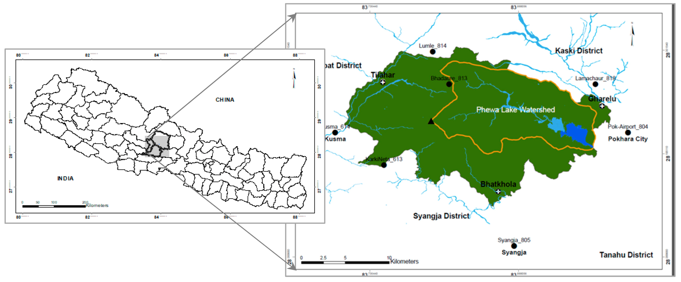
2.2. Case Study
2.2.1. Baseline
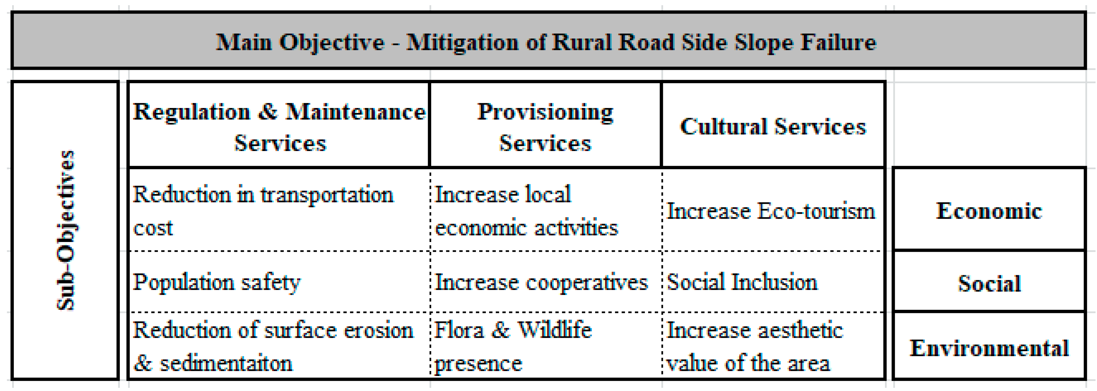
2.2.2. Objectives
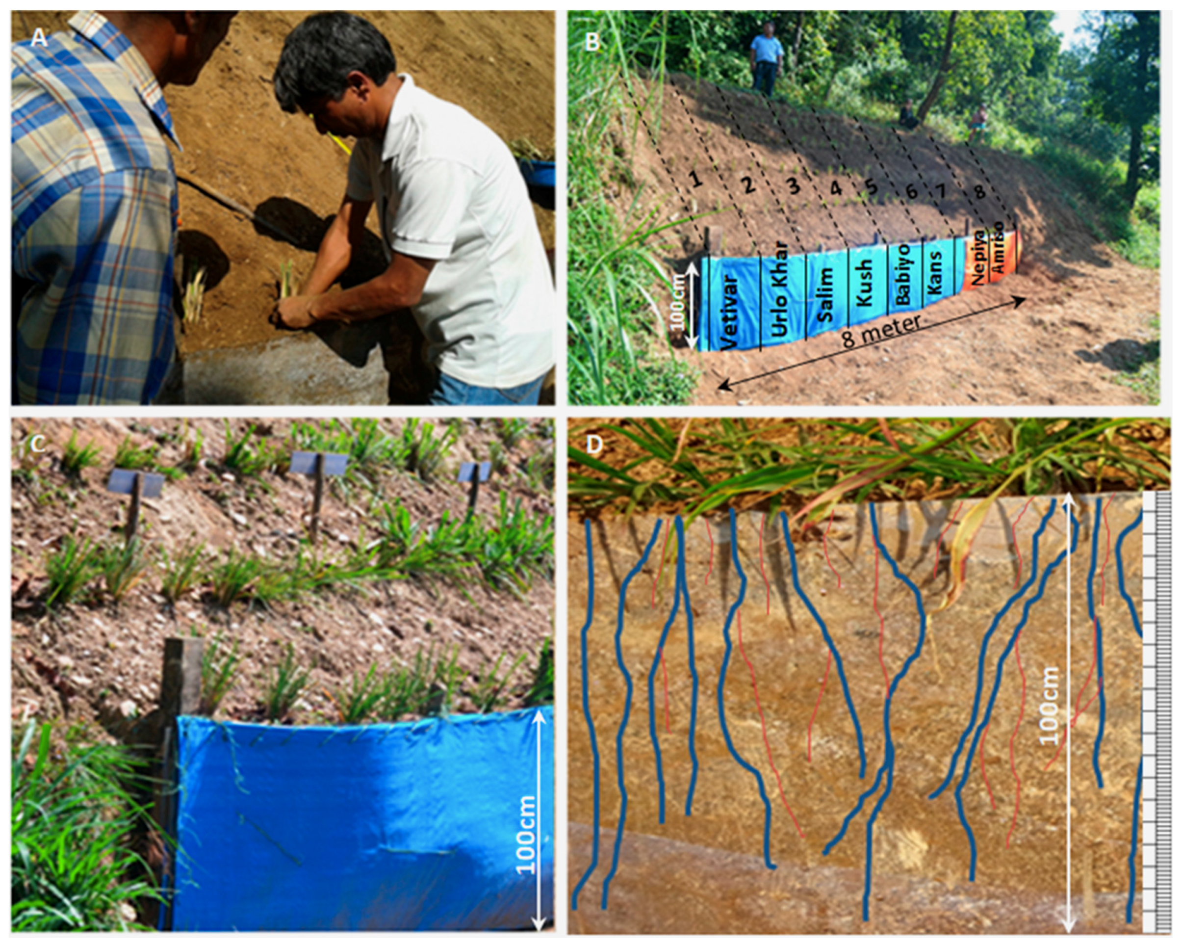
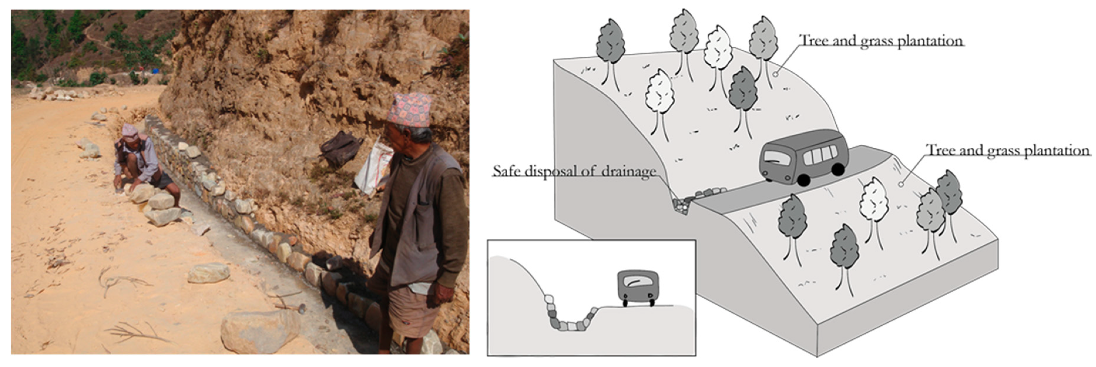
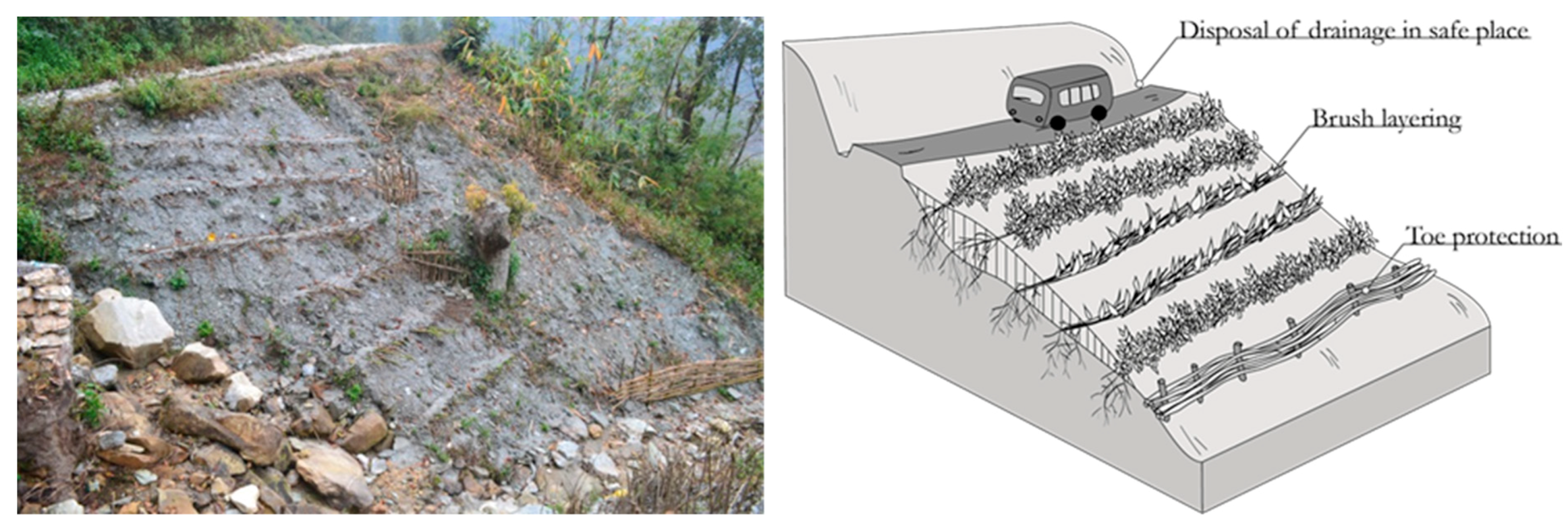
2.2.3. Selection, Design, and Implementation of NbS Techniques
2.2.4. Monitoring and Evaluation
3. Results and Discussion
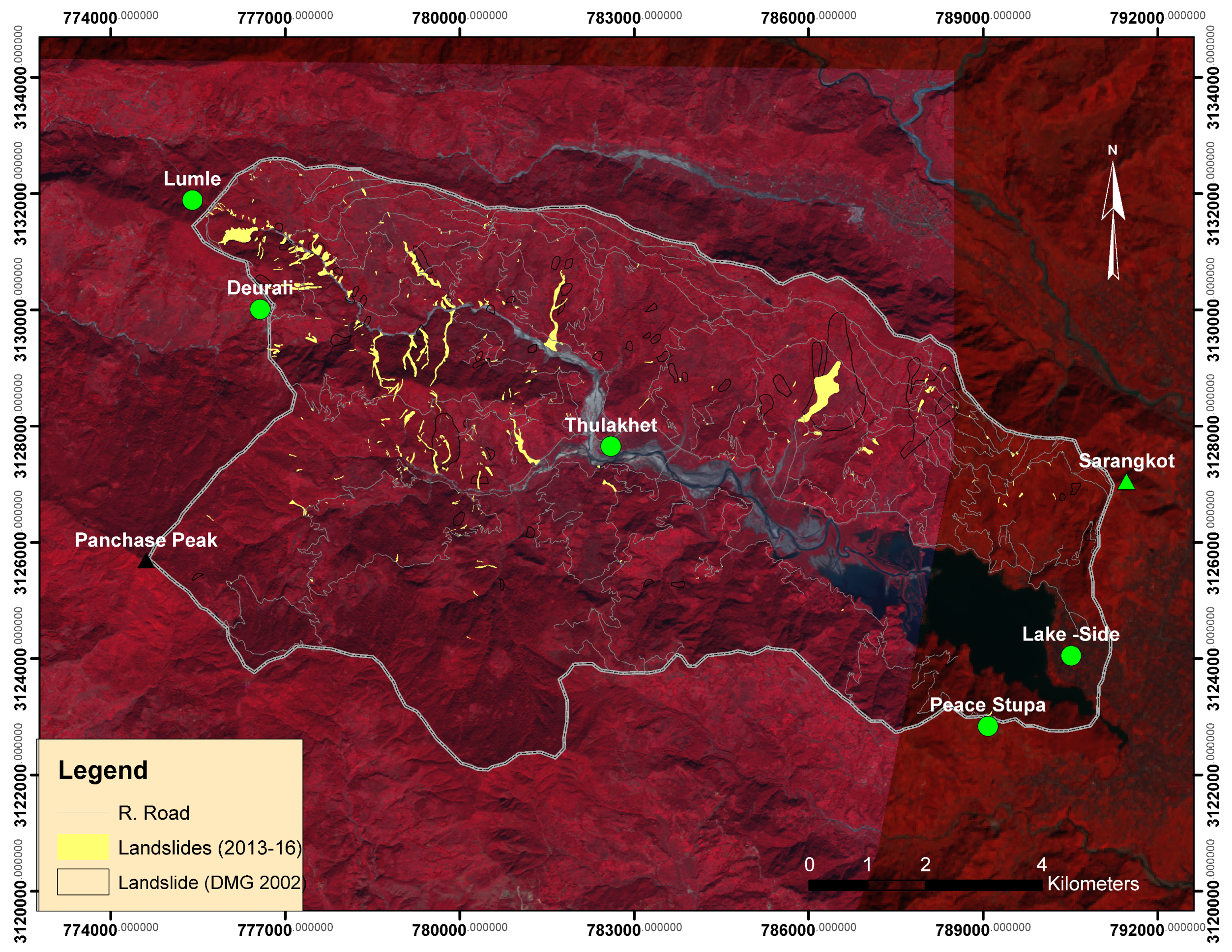
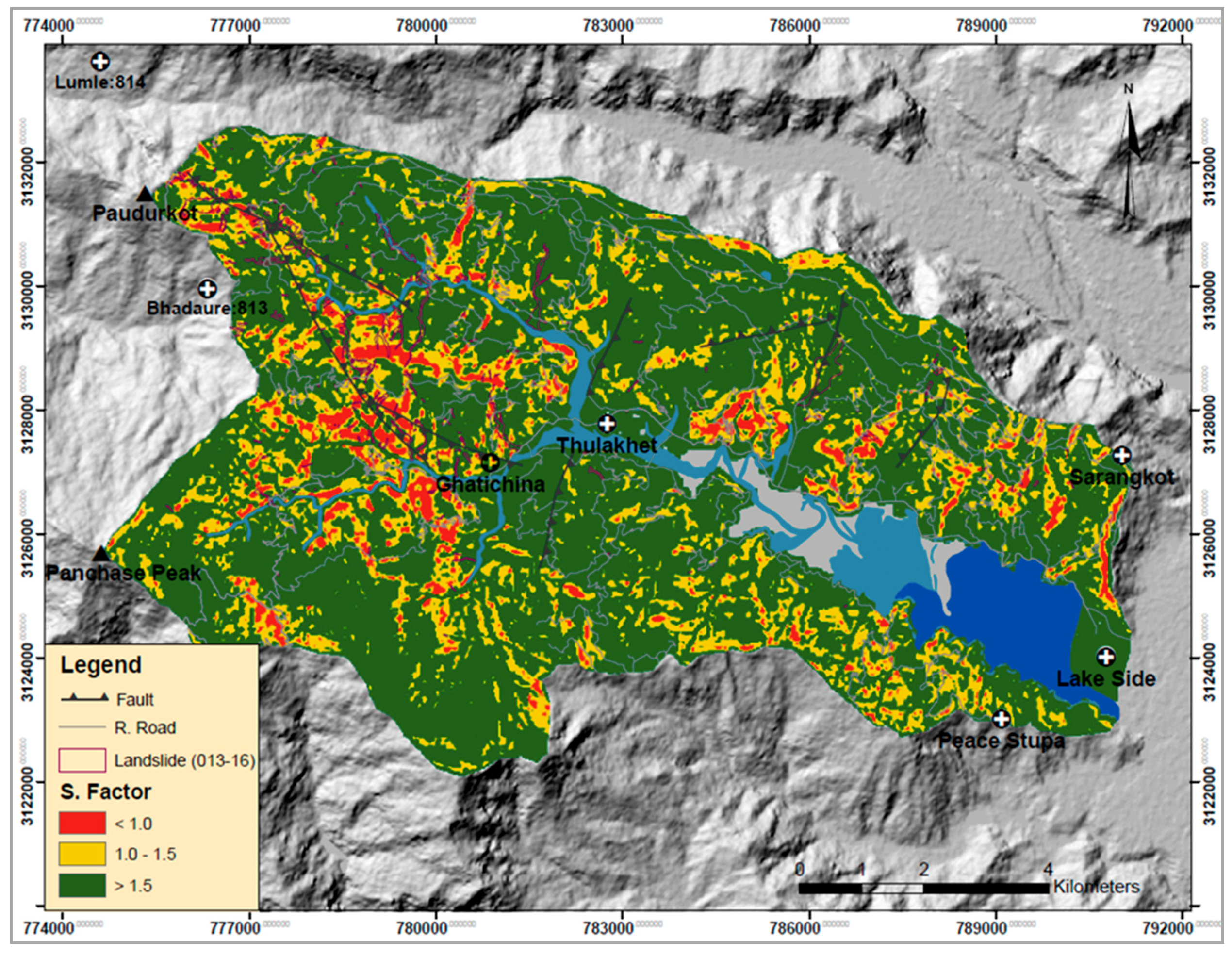
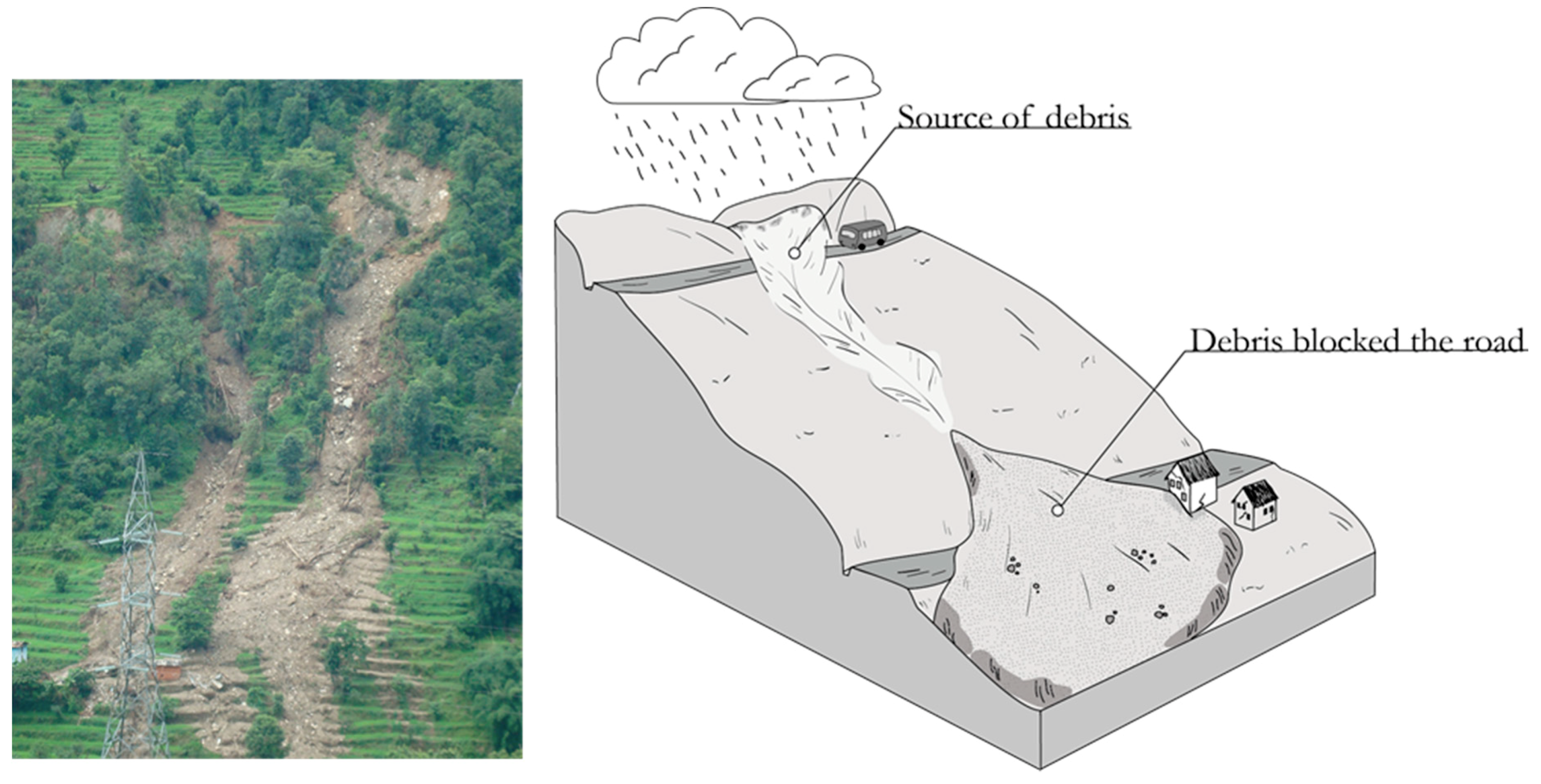
3.1. Rural Road and Landslides in Phewa Watershed of Panchase Region
3.2. KPI of the Plant Species
3.3. Proposed Eco-Safe Rural Road Assessment Framework
- Define the problems to be addressed (baseline);
- Establish the eco-safe road objectives;
- Identify suitable NbS measures and alternatives for eco-safe rural roads;
- Implement the eco-safe rural road plan;
- Establish an awareness and communication plan;
- Mobilize the community for implementation and upscaling;
- Establish monitoring and evaluation plan and follow-up.
- Identify and evaluate available (digital) data (e.g., DEM, RS images);
- Assess rural road alignment:
- ○
- Map the unstable and shallow landslides failure;
- ○
- Assess the drainage patterns;
- Identify and evaluate the soil physical properties and soil depth to bed rock;
- Evaluate the rainfall intensity through the regional IDF model and assess the soil moisture considering the antecedent rainfall and rainy days;
- Implement the infinite-slope stability model considering the rainfall-induced saturation depth to better understand the most unstable locations and the road alignment passing through.
4. Conclusions
Author Contributions
Funding
Acknowledgments
Conflicts of Interest
References
- UNDP. Proceedings of Nepal Country Workshop on Environments of the Poor in the Context of Climate Change and the Green Economy July 2011; Government of Nepal, National Planning Comission, UNDP and UNEP: Kathmandu, Nepal, 2011.
- UNDP. Economic Analysis of Local Government Investment in Rural Roads in Nepal; LGCDP, UNDP, UNEP: Kathmandu, Nepal, 2011. [Google Scholar]
- McAdoo, B.G.; Quak, M.; Gnyawali, K.R.; Adhikari, B.R.; Devkota, S.; Rajbhandari, P.L.; Sudmeier-Rieux, K. Roads and landslides in Nepal: How development affects environmental risk. Nat. Hazards Earth Syst. Sci. 2018, 18, 3203–3210. [Google Scholar] [CrossRef]
- Sudmeier-Rieux, K.; McAdoo, B.G.; Devkota, S.; Rajbhandari, P.C.L.; Howell, J.; Sharma, S. Invited perspectives: Mountain roads in Nepal at a new crossroads. Nat. Hazards Earth Syst. Sci. 2019, 19, 655–660. [Google Scholar] [CrossRef]
- Koirala, G.P. Economic Analysis of Local Government Investments in Rural Roads: Reducing Poverty through Managing Climate and Environment Risks. In Environments of the Poor in the Context of Climate Change and the Green Economy; Government of Nepal: Kathmandu, Nepla, 2011. [Google Scholar]
- Jaboyedoff, M.; Michoud, C.; Derron, M.-H.; Voumard, J.; Leibundgut, G.; Sudmeier-Rieux, K.; Nadim, F.; Nadim, F.; Leroi, E. Human-induced landslides: Toward the analysis of anthropogenic changes of the slope environment. In Landslides and Engineered Slopes. Experience, Theory and Practice; CRC Press: Boca Raton, FL, USA, 2016. [Google Scholar]
- Petley, D.N. On the impact of climate change and population growth on the occurrence of landslides in Asia. Q. J. Eng. Geol. Hydrogeol. 2010, 43, 487–496. [Google Scholar] [CrossRef]
- Dahal, R.K.; Hasegawa, S.; Masuda, T.; Yamanaka, M. Roadside slope failures in Nepal during torrential rainfall and their mitigation. In Disaster Mitigation of Debris Flows, Slope Failures and Landslides; Universal Academy Press, Inc.: Tokyo, Japan, 2006; pp. 503–514. [Google Scholar]
- Laban, P. Landslide Occurrence in Nepal; Working Papar No. 13; Integrated Watershed Management Project: Kathmandu, Nepal, 1979. [Google Scholar]
- DOR. National Transportation Policy Ministry of Physical Planning and Works, 2058 (2001/2002); Government of Nepal: Kathmandu, Nepal, 2002; p. 15.
- DOR. Road Network Data; Roads, D.o., Ed.; Government of Nepal: Kathmandu, Nepal, 2017; p. 17. [Google Scholar]
- Petley, D.N.; Hearn, G.J.; Hart, A.; Rosser, N.; Dunning, S.; Oven, K.; Mitchell, W.A. Trends in Landslide occurrence in Nepal. Nat. Hazards 2007, 43, 23–44. [Google Scholar] [CrossRef]
- BBC. Nepal: Landslides Triggers by Rain Kill at Least 29 People. Available online: https://www.bbc.com/news/world-asia-33714147 (accessed on 15 August 2015).
- IUCN. Geological Assessment of Dunde Landslide/Debris Flows and Identifying Ecosystem Based Mitigation Measures; IUCN: Lalitpur, Nepal, 2016; p. 105. [Google Scholar]
- DesInventar. Nepal Disaster Profile. Available online: http://www.desinventar.net/DesInventar/profiletab.jsp?countrycode=npl (accessed on 29 April 2019).
- Reliefweb. NEPAL: Road-Building Leads to Deadlier Landslides. Available online: https://reliefweb.int/report/nepal/nepal-road-building-leads-deadlier-landslides (accessed on 29 April 2019).
- Guragai, J., Sr.; Divisional Engineer, Department of Local Infrastructures (DoLI), Government of Nepal, Kathmandu, Nepal. Personal Communication, 2019.
- Devkota, S.; Sudmeier-Rieux, K.; Adhikari, A.; Khanal, R.; Penna, I.; Jaboyedoff, M. Investing in Ecosystem Aproach for more resilient Disaster Risks Reduction: The case eco-safe roads in Nepal. In FIG-ISPRS Workshop 2015: International Workshop on Role of Land Professionals and SDI in Disaster Risk Reduction in the Context of Post 2015 Nepal Earthquake, Kathmandu, Nepal, 25–27 November 2015; Department of Survey: Kathmandu, Nepal, 2015; p. 13. [Google Scholar]
- Sudmeier-Rieux, K.; Jaquet, S.; Derron, M.-H.; Jaboyedoff, M.; Devkota, S. A Case Study of Landslides and Coping Strategies in Two Villages of Central-Eastern Nepal. J. Appl. Geogr. 2011, 32, 680–690. [Google Scholar] [CrossRef]
- World Bank. Nepal Road Sector Assessment Study; Government of Nepal, World Bank, Asian Development Bank, DFID, SDC: Kathmandu, Nepal, 2012; p. 55.
- Gray, D.H.; Sotir, R.B. Biotechnical and Soil Bioengineering Slope Stabilization: A Practical Guide for Erosion Control; John Wiley & Sons: Hoboken, NJ, USA, 1996. [Google Scholar]
- Dhital, Y.P.; Kayastha, R.B.; Shi, J. Soil bioengineering application and practices in Nepal. Environ. Manag. 2013, 51, 354–364. [Google Scholar] [CrossRef] [PubMed]
- Howell, J. Application of bio-engineering in slope stabilization: Experience from Nepal. In Landslide Hazard Mitigation in the Hindu Kush-Himalayas; Tianchi, L., Chalise, S., Upreti, B.N., Eds.; International Centre for Integrated Mountain Development (ICIMOD): Kathmandu, Nepal, 2001; p. 15. [Google Scholar]
- Rizvi, A.R.; Baig, S.; Verdone, M. Ecosystems Based Adaptation: Knowledge Gaps in Making an Economic Case for Investing in Nature Based Solutions for Climate Change; IUCN: Gland, Switzerland, 2015; p. 48. [Google Scholar]
- Stokes, A.; Sotir, R.; Chen, W.; Ghestem, M. Soil bio-and eco-engineering in China: Past experience and future priorities. Ecol. Eng. 2010, 36, 247–257. [Google Scholar] [CrossRef]
- Norris, J.E.; Stokes, A.; Mickovski, S.B.; Cammeraat, E.; van Beek, R.; Nicoll, B.C.; Achim, A. Slope Stability and Erosion Control: Ecotechnological Solutions; Springer: Dordrecht, The Netherlands, 2008. [Google Scholar]
- Faivre, N.; Fritz, M.; Freitas, T.; de Boissezon, B.; Vandewoestijne, S. Nature-Based Solutions in the EU: Innovating with nature to address social, economic and environmental challenges. Environ. Res. 2017, 159, 509–518. [Google Scholar] [CrossRef] [PubMed]
- EEA. Exploring Nature-Based Solutions: The Role of Green Infrastructure in Mitigating the Impacts of Weather- and Climate Change-Related Natural Hazards; European Environment Agency, Publications Office of the European Union: Luxembourg, 2015; p. 66. [Google Scholar]
- Lafortezza, R.; Chen, J.; van den Bosch, C.K.; Randrup, T.B. Nature-based solutions for resilient landscapes and cities. Environ. Res. 2018, 165, 431–441. [Google Scholar] [CrossRef]
- Maes, J.; Jacobs, S. Nature-based solutions for Europe’s sustainable development. Conserv. Lett. 2017, 10, 121–124. [Google Scholar] [CrossRef]
- Mickovski, S.; Thomson, C. Developing a framework for the sustainability assessment of eco-engineering measures. Ecol. Eng. 2017, 109, 145–160. [Google Scholar] [CrossRef]
- Mickovski, S.B. Why is the future ready for Environmental Geotechnics. Environ. Geotech. 2016, 3, 63–64. [Google Scholar] [CrossRef]
- Young, R.; Zanders, J.; Lieberknecht, K.; Fassman-Beck, E. A comprehensive typology for mainstreaming urban green infrastructure. J. Hydrol. 2014, 519, 2571–2583. [Google Scholar] [CrossRef]
- Bennett, E.M.; Cramer, W.; Begossi, A.; Cundill, G.; Díaz, S.; Egoh, B.N.; Geijzendorffer, I.R.; Krug, C.B.; Lavorel, S.; Lazos, E.; et al. Linking biodiversity, ecosystem services, and human well-being: Three challenges for designing research for sustainability. Curr. Opin. Environ. Sustain. 2015, 14, 76–85. [Google Scholar] [CrossRef]
- Calliari, E.; Staccione, A.; Mysiak, J. An assessment framework for climate-proof nature-based solutions. Sci. Total Environ. 2019, 656, 691–700. [Google Scholar] [CrossRef]
- Santoro, S.; Pluchinotta, I.; Pagano, A.; Pengal, P.; Cokan, B.; Giordano, R. Assessing stakeholders’ risk perception to promote Nature Based Solutions as flood protection strategies: The case of the Glinščica river (Slovenia). Sci. Total Environ. 2019, 655, 188–201. [Google Scholar] [CrossRef]
- van Wesenbeeck, B.; IJff, S.; Jongman, B.; Balog, S.; Kaupa, S.; Bosche, L.; Lange, G.M.; Holm-Nielsen, N.; Nieboer, H.; Taishi, Y.; et al. Implementing Nature Based Flood Protection: Principles and Implementation Guidance; World Bank Group: Washington, DC, USA, 2017. [Google Scholar]
- European Commission. Nature-Based Solutions. Available online: https://ec.europa.eu/research/environment/index.cfm?pg=nbs (accessed on 10 May 2014).
- Nesshöver, C.; Assmuth, T.; Irvine, K.N.; Rusch, G.M.; Waylen, K.A.; Delbaere, B.; Haase, D.; Jones-Walters, L.; Keune, H.; Kovacs, E.; et al. The science, policy and practice of nature-based solutions: An interdisciplinary perspective. Sci. Total Environ. 2017, 579, 1215–1227. [Google Scholar] [CrossRef]
- Cariñanos, P.; Calaza-Martínez, P.; O’Brien, L.; Calfapietra, C. The cost of greening: Disservices of urban trees. In The Urban Forest-Cultivating Green Infrastructure for People and the Environment; David, P., Carlo, C., Roeland, S., Liz, O.B., Silvija, K.O., Giovanni, S., Rocío, A.d.A., Eds.; Springer International Publishing AG: Berlin/Heidelberg, Germany, 2017; Volume 7, p. 9. [Google Scholar]
- Bauduceau, N.; Berry, P.; Cecchi, C.; Elmqvist, T.; Fernandez, M.; Hartig, T.; Krull, W.; Mayerhofer, E.; Sandra, N.; Noring, L.; et al. Towards an EU Research and Innovation Policy Agenda for Nature-Based Solutions & Re-Naturing Cities: Final Report of the Horizon 2020 Expert Group on ‘Nature-Based Solutions and Re-naturing Cities’; Publications Office of the European Union: Brussels, Belgium, 2015. [Google Scholar]
- Raymond, C.M.; Frantzeskaki, N.; Kabisch, N.; Berry, P.; Breil, M.; Nita, M.R.; Geneletti, D.; Calfapietra, C.; et al. A framework for assessing and implementing the co-benefits of nature-based solutions in urban areas. Environ. Sci. Policy 2017, 77, 15–24. [Google Scholar] [CrossRef]
- Mao, Z.; Bourrier, F.; Stokes, A.; Fourcaud, T. Three-dimensional modelling of slope stability in heterogeneous montane forest ecosystems. Ecol. Model. 2014, 273, 11–22. [Google Scholar] [CrossRef]
- MacNeil, D.J.; Steele, D.P.; McMahon, W.; Carder, D.R. Vegetation for Slope Stability; Prepared for Quality Services, Civil Engineering, Highways Agency; TRL: Wokingham, UK, 2001. [Google Scholar]
- Truong, P. Vetiver System for Infrastructure Protection; Veticon Consulting: Brisbane, Australia, 2000; Volume 108, p. 11. [Google Scholar]
- Petrone, A.; Preti, F. Soil bioengineering for risk mitigation and environmental restoration in a humid tropical area. Hydrol. Earth Syst. Sci. 2010, 14, 239–250. [Google Scholar] [CrossRef]
- Wu, T.H.; McKinnell, W.P., III; Swanston, D.N. Strength of tree roots and landslides on Prince of Wales Island, Alaska. Can. Geotech. J. 1979, 16, 19–33. [Google Scholar] [CrossRef]
- Bohm, W. Methods of Studying Root Systems; Springer: Berlin/Heidelberg, Germany; New York, NY, USA, 1979. [Google Scholar]
- Pohl, M.; Stroude, R.; Buttler, A.; Rixen, C. Functional traits and root morphology of alpine plants. Ann. Bot. 2011, 108, 537–545. [Google Scholar] [CrossRef] [PubMed]
- Bro, R.; Smilde, A.K. Principal component analysis. Anal. Methods 2014, 6, 2812–2831. [Google Scholar] [CrossRef]
- Chae, B.-G.; Lee, J.-H.; Park, H.-J.; Choi, J. A method for predicting the factor of safety of an infinite slope based on the depth ratio of the wetting front induced by rainfall infiltration. Nat. Hazards Earth Syst. Sci. 2015, 15, 1835–1849. [Google Scholar] [CrossRef]
- Remondo, J.; González, A.; De Terán, J.R.D.; Cendrero, A.; Fabbri, A.; Chung, C.-J.F. Validation of Landslide Susceptibility Maps; Examples and Applications from a Case Study in Northern Spain. Nat. Hazards 2003, 30, 437–449. [Google Scholar] [CrossRef]
- Deng, X.; Li, L.; Tan, Y. Validation of Spatial Prediction Models for Landslide Susceptibility Mapping by Considering Structural Similarity. Int. J. Geo-Inf. 2017, 6, 10. [Google Scholar] [CrossRef]
- Devkota, S.; Shakya, N.; Sudmeier-Rieux, K.; Jaboyedoff, M.; Van Westen, C.; Mcadoo, B.; Adhikari, A. Development of Monsoonal Rainfall Intensity-Duration-Frequency (IDF) Relationship and Empirical Model for Data-Scarce Situations: The Case of the Central-Western Hills (Panchase Region) of Nepal. Hydrology 2018, 5, 27. [Google Scholar] [CrossRef]
- Devkota, S.; Shakya, N.M.; Sudmeier-Rieux, K.; McAdoo, B.G.; Jaboyedoff, M. (Eds.) Predicting soil depth to bedrock in an anthropogenic landscape: A case study of Phewa Watershed in Panchase region of Central-Western Hills, Nepal. In Proceedings of the 11th IAEG Asian Regional Conference (ARC-11)—Engineering geology for Geodisaster Management, Kathmandu, Nepal, 28–30 November 2017; Nepal geological Society: Kathmandu, Nepal, 2018. [Google Scholar]
- Dingman, S.L. Physical Hydrology; Prentice Hall: Upper Saddle River, NJ, USA, 2002; p. 646. [Google Scholar]
- Devkota, S.; Sudmeier-Rieux, K.; Penna, I.; Eberle, S.; Jaboyedoff, M.; Adhikari, A.; et al. Community-Based Bio-Engineering for Eco-Safe Roads in Nepal; University of Lausanne: Lausanne, Switzerland; International Union for Conservation of Nature: Gland, Switzerland; Nepal and Department of Soil Conservation and Watershed Management: Kathmandu, Nepal; Government of Nepal: Kathmandu, Nepal, 2014; p. 95.
- Howell, J. Roadside Bio-Engineering: Reference Manual; Omar, S., Ed.; Department of Roads, Government of Nepal: Kathmandu, Nepal, 1999; p. 216.
- Howell, J. Roadside Bio-Engineering: Site Handbook; Omar, S., Ed.; Department of Roads, Government of Nepal: Kathmandu, Nepal, 1999; p. 160.
- ORCDC. Vetiver Grass Installation Guide: Pacific Islands Area; Oahu Resource Conservation and Development Council in cooperation with USDA Natural Resource Conservation Service (NRCS): Kunia Camp, HI, USA, 2012. [Google Scholar]
- Larsen, M.C. Rainfall-triggered landslides, anthropogenic hazards and mitigation strategies. Adv. Geosci. 2008, 14, 147–153. [Google Scholar] [CrossRef]
- Vuillez, C.; Tonini, M.; Sudmeier-Rieux, K.; Devkota, S.; Derron, M.-H.; Jaboyedoff, M. Land use changes, landslides and roads in the Phewa Watershed, Western Nepal from 1979 to 2016. Appl. Geogr. 2018, 94, 30–40. [Google Scholar] [CrossRef]
- DMG. Cartographer Engineering and Environmental Geologicla Map of Pôkhara Valley; Government of Nepal: Kathmandu, Nepal, 2002.
- Devkota, B.; Paudel, P.; Omura, H.; Kubota, T.; Morita, K. Uses of vegetative measures for erosion mitigation in Mid Hill areas of Nepal. Kyushu J. For. Res. 2006, 59, 265–268. [Google Scholar]
- Karki, R.; Schickhoff, U.; Scholten, T.; Böhner, J. Rising precipitation extremes across Nepal. Climate 2017, 5, 4. [Google Scholar] [CrossRef]
- Fernandes, J.P.; Guiomar, N. Nature-based solutions: The need to increase the knowledge on their potentialities and limits. Land Degrad. Dev. 2018, 29, 1925–1939. [Google Scholar] [CrossRef]
- Stokes, A.; Douglas, B.G.; ourcaud, F.T.; Giadrossich, F.; Gillies, C.; Hubble, T.; Kim, J.H.; Loades, K.W.; Mao, Z.; McIvor, I.R.; et al. Ecological mitigation of hillslope instability: Ten key issues facing researchers and practitioners. Plant Soil 2014, 377, 1–23. [Google Scholar] [CrossRef]
- Kabisch, N.; Frantzeskaki, N.; Pauleit, S.; Naumann, S.; Davis, M.; Artmann, M.; Haase, D.; Knapp, S.; Korn, H.; Stadler, J.; et al. Nature-based solutions to climate change mitigation and adaptation in urban areas: Perspectives on indicators, knowledge gaps, barriers, and opportunities for action. Ecol. Soc. 2016, 21, 39. [Google Scholar] [CrossRef]
- Connop, S.; Vandergert, P.; Eisenberg, B.; Collier, M.J.; Nash, C.; Clough, J.; Newport, D. Renaturing cities using a regionally-focused biodiversity-led multifunctional benefits approach to urban green infrastructure. Environ. Sci. Policy 2016, 62, 99–111. [Google Scholar] [CrossRef]
- Kathmandupost. Eco-Safe Roads. Available online: https://kathmandupost.ekantipur.com/news/2016-10-02/eco-safe-roads.html (accessed on 9 May 2019).
- Miththapala, S. EPIC External Review; International Union for Conservaiton of Nature (IUCN): Gland, Switzerland, 2017; p. 259. [Google Scholar]
- Cohen-Shacham, E.; Walters, G.; Janzen, C.; Maginnis, S. Nature-Based Solutions to Address Global Societal Challenges; IUCN: Gland, Switzerland, 2016; p. 97. [Google Scholar]
- Frantzeskaki, N.; Borgström, S.; Gorissen, L.; Egermann, M.; Ehnert, F. Nature-Based Solutions Accelerating Urban Sustainability Transitions in Cities: Lessons from Dresden, Genk and Stockholm Cities. In Nature-Based Solutions to Climate Change Adaptation in Urban Areas; Springer: Berlin/Heidelberg, Germany, 2017; pp. 65–88. [Google Scholar]


| Author(s) | Challenges | Scale | Type of NbS | Aim | Approach and Method |
|---|---|---|---|---|---|
| EEA [28] | DRR (CC-related hazards, landslides) | L, R | Intervention of green infrastructures to mitigate extreme weather and climate-related events such as landslides | To assess the hazard potential due to extreme weather and identify GI elements, pursued at landscape scale with a focus on rural environments | To assess conditions of ecosystem services, evaluate hazard level (high, medium, and low) and prepare hazard map, and design and implement GI to mitigate/reduce the impact of disaster risks |
| Raymond et al. [42] | CCM and CCA, WRM, GI, PPG, UR | U | No specific measures assessed, reference to wider categories of ecosystem-based approaches, and green–blue infrastructures such as ES, ecological engineering, ecosystem-based management | To assess the NbS through economic, environmental, and social co-benefits and cost analysis | For each challenge, potential NbS are identified together with expected impacts, indicators of impacts, related metrics, and assessment methods |
| Van Wesenbeek et al. [37] | DRR (flood) | L, R | Interventions implying managing the present ecosystem or activity intervening on/creating new ecosystem | To provide guidance for planning, assessing, designing, implementing, monitoring, managing, and evaluating the NbS | Flood risk management project cycle |
| Mickovski and Thomson [31] | Sustainability assessment of eco-engineering | L, R | To assess the sustainability of eco-engineering measures | To develop a framework for the sustainability assessment of eco-engineering measures | Bench marking of key performances indicators (KPIs) through sustainable assessment method (SAM) |
| Calliari et al. [35] | DRR (CC-related hazards) | L, R | No specific measures assessed, regulation and maintenance, provisioning and cultural services | To assess direct benefits/costs and co-benefits/costs | To assess baseline, backcasting, and setting the criteria to evaluate alternatives |
| Demonstration Site/Local Species Name | Species Name | Plantation Area (m2) | Number of Saplings | Spacing, Horizontal:Vertical (cm) |
|---|---|---|---|---|
| Gharelu | ~1210 | |||
| Urlo-Khar | Cymbopogon microtheca | 450 | 4500 | 10:100 |
| Nepiyar | Penniseluim purpurreum | 300 | 3000 | 10:100 |
| Salim-Khar | Chirysopogon gryllus | 200 | 2000 | 10:100 |
| Amriso | Thysanalana maxima | 260 | 1050 | 30:100 |
| Tilahar | ~620 | |||
| Urlo-Khar | C. microtheca | 120 | 1200 | 10:100 |
| Nepiyar | P. purpurreum | 50 | 500 | 10:100 |
| Salim-Khar | C. gryllus | 75 | 750 | 10:100 |
| Amriso | T. maxima | 375 | 1500 | 30:100 |
| Bhatkhola/Saunepani | ~156 | |||
| Urlo-Khar | C. microtheca | 25 | 250 | 10:100 |
| Nepiyar | P. purpurreum | 18 | 180 | 10:100 |
| Salim-Khar | C. gryllus | 15 | 150 | 10:100 |
| Amriso | T. maxima | 98 | 390 | 30:100 |
| Species Local Name | Species Name | Survival (%) | Canopy Cover (%) | Biom-s-Dry (kg) | Biom-r-Dry (kg) | RAR-Deep | RAR-Shallow | Rooting Depth (cm) | Tr (MPa) | cr (kPa) |
|---|---|---|---|---|---|---|---|---|---|---|
| Vetiver | C. zizanioides | 80.00 | 70.57 | 0.83 | 0.32 | 0.0018 | 0.0241 | 0–100 | 45.4 | 14.08 |
| Urlo-Khar | C. microtheca | 78.67 | 48.33 | 0.63 | 0.33 | 0.0018 | 0.0092 | 0–50 | 24.11 | 7.48 |
| Babiyo | P. purpurreum | 81.33 | 86.67 | 0.78 | 0.54 | 0.0001 | 0.0128 | 0–30 | 18.25 | 5.66 |
| Nepiyar | C. gryllus | 76.00 | 60.27 | 0.39 | 0.28 | 0.0004 | 0.0082 | 0–30 | 25.28 | 7.84 |
| Salim-Khar | E. binata | 66.67 | 51.43 | 0.18 | 0.19 | 0.0003 | 0.0104 | 0–50 | 23.1 | 7.17 |
| Kans | D. bipinnata | 65.33 | 29.70 | 0.26 | 0.19 | 0.0006 | 0.0119 | 0–30 | 20.24 | 6.28 |
| Kush | S. spontaneum | 72.00 | 41.10 | 0.33 | 0.15 | 0.0010 | 0.0084 | 0–30 | 21.53 | 6.68 |
| Amriso | T. maxima | 70.67 | 78.63 | 0.62 | 0.30 | 0.0099 | 0.0657 | 0–80 | 26.65 | 8.27 |
© 2019 by the authors. Licensee MDPI, Basel, Switzerland. This article is an open access article distributed under the terms and conditions of the Creative Commons Attribution (CC BY) license (http://creativecommons.org/licenses/by/4.0/).
Share and Cite
Devkota, S.; Shakya, N.M.; Sudmeier-Rieux, K. Framework for Assessment of Eco-Safe Rural Roads in Panchase Geographic Region in Central–Western Nepal Hills. Environments 2019, 6, 59. https://doi.org/10.3390/environments6060059
Devkota S, Shakya NM, Sudmeier-Rieux K. Framework for Assessment of Eco-Safe Rural Roads in Panchase Geographic Region in Central–Western Nepal Hills. Environments. 2019; 6(6):59. https://doi.org/10.3390/environments6060059
Chicago/Turabian StyleDevkota, Sanjaya, Narendra Man Shakya, and Karen Sudmeier-Rieux. 2019. "Framework for Assessment of Eco-Safe Rural Roads in Panchase Geographic Region in Central–Western Nepal Hills" Environments 6, no. 6: 59. https://doi.org/10.3390/environments6060059
APA StyleDevkota, S., Shakya, N. M., & Sudmeier-Rieux, K. (2019). Framework for Assessment of Eco-Safe Rural Roads in Panchase Geographic Region in Central–Western Nepal Hills. Environments, 6(6), 59. https://doi.org/10.3390/environments6060059