

Assessment of Trail Erosion Under the Impact of Tourist Traffic in the Bucegi Mountains, Romanian Carpathians

Abstract
1. Introduction
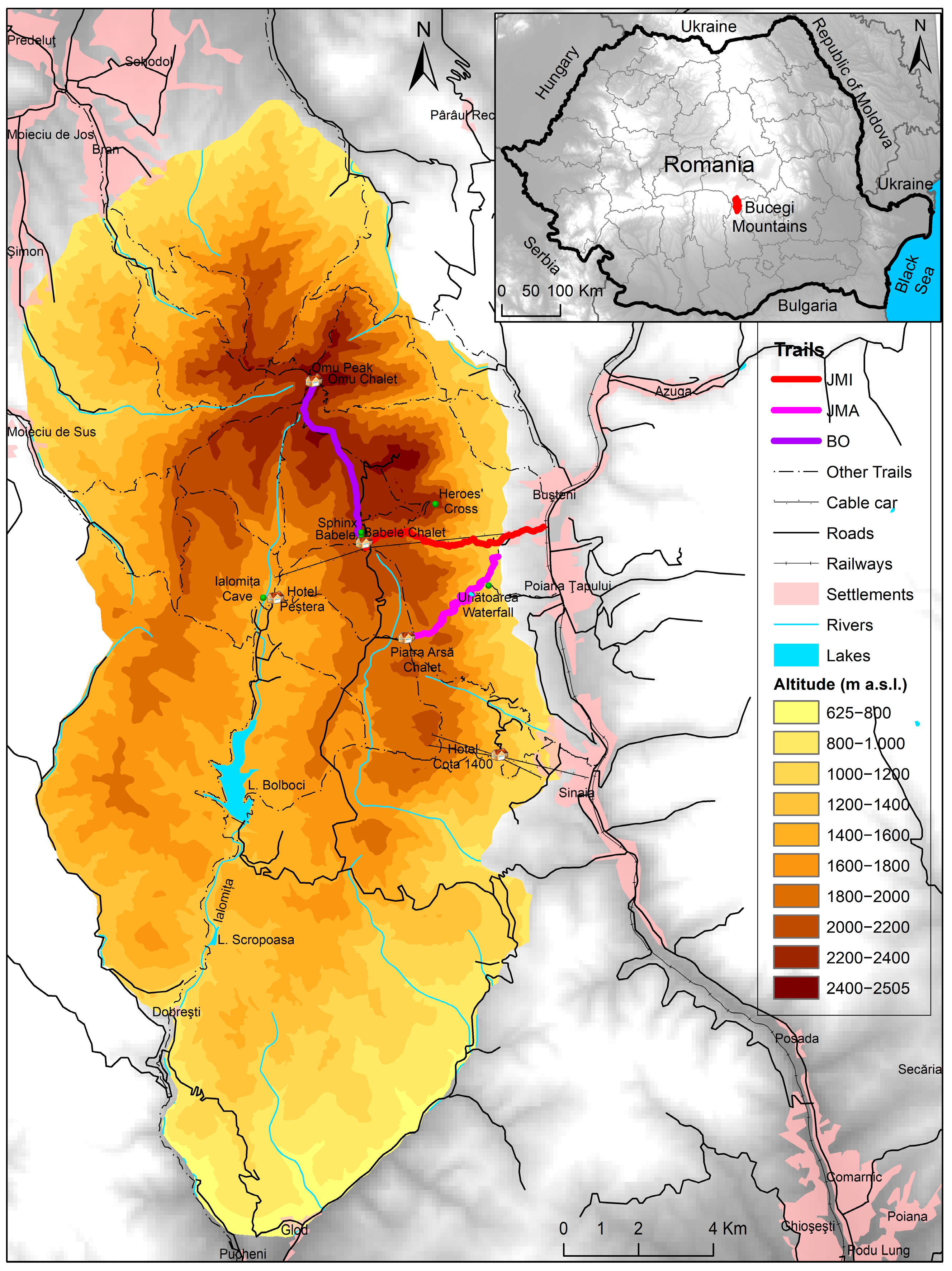
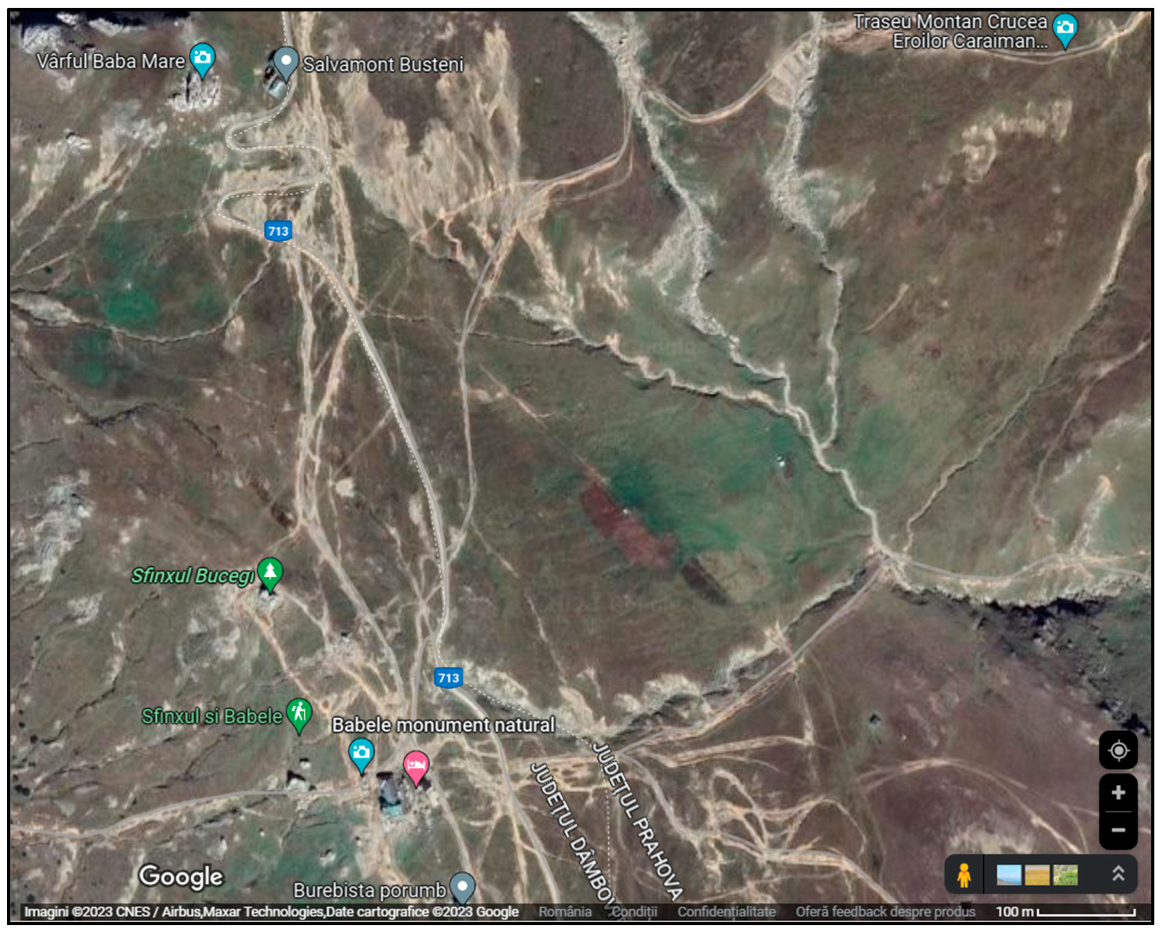
2. Study Area
2.1. Geographic and Environmental Setting
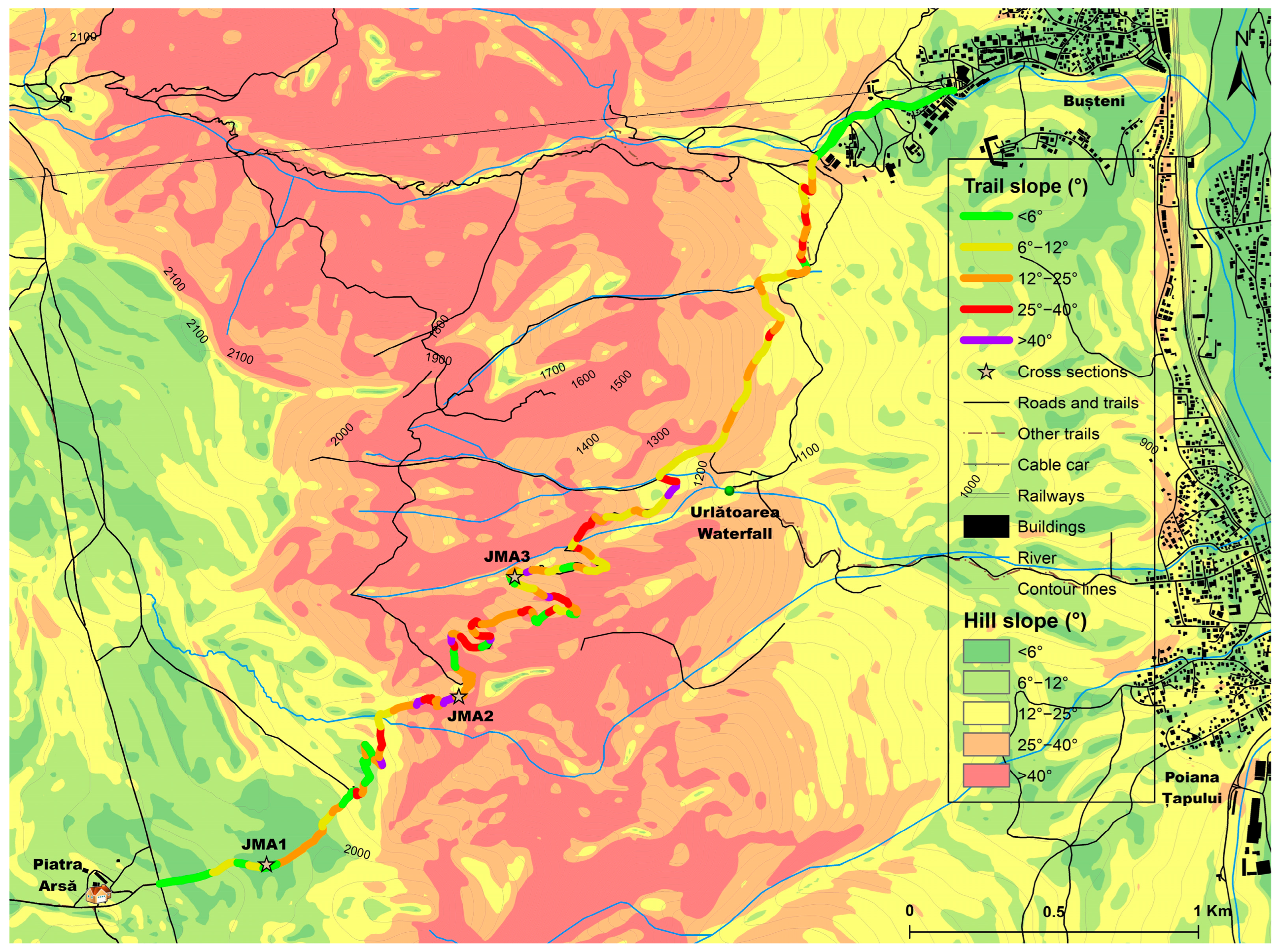
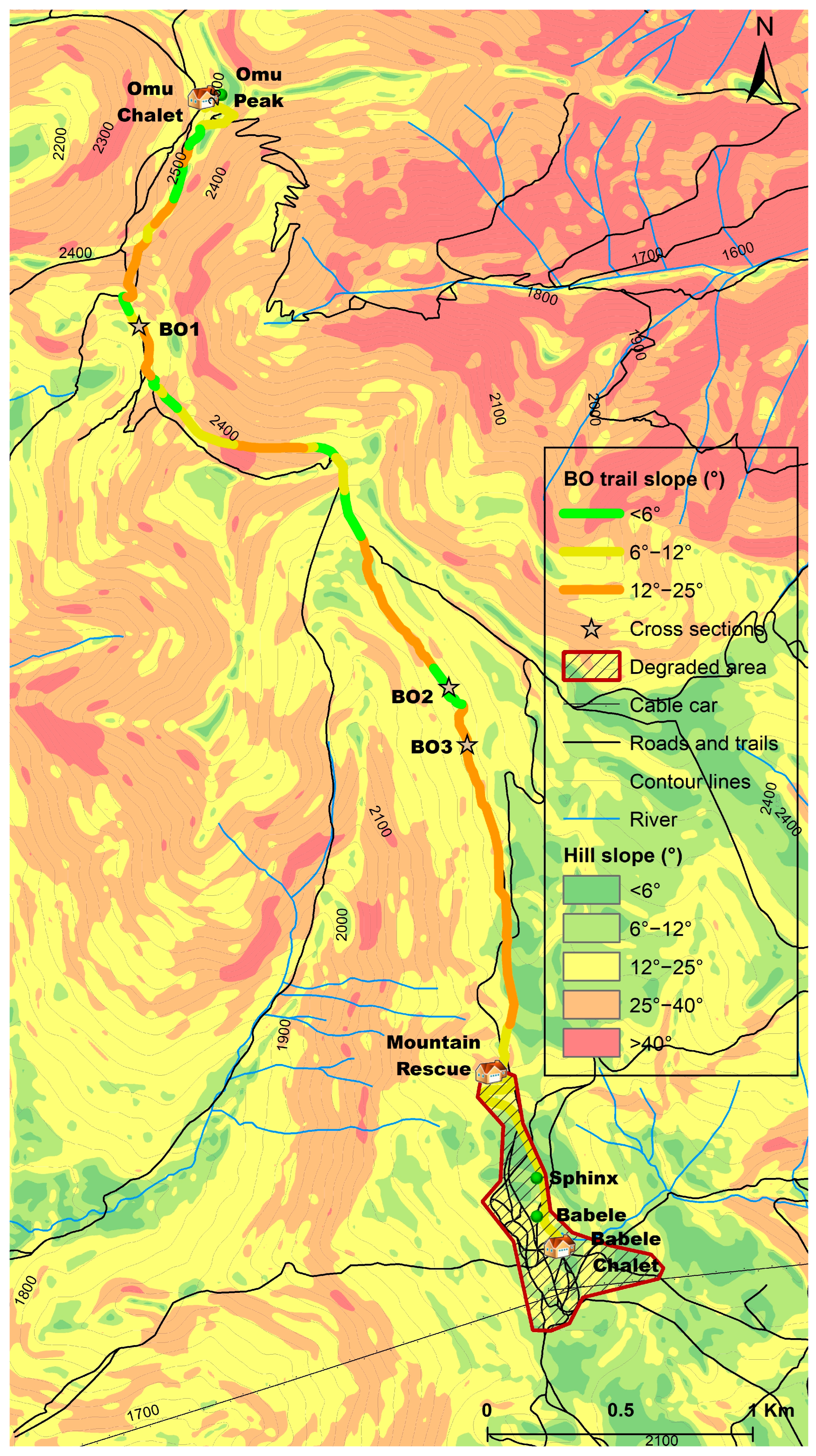
2.2. Tourist Trails
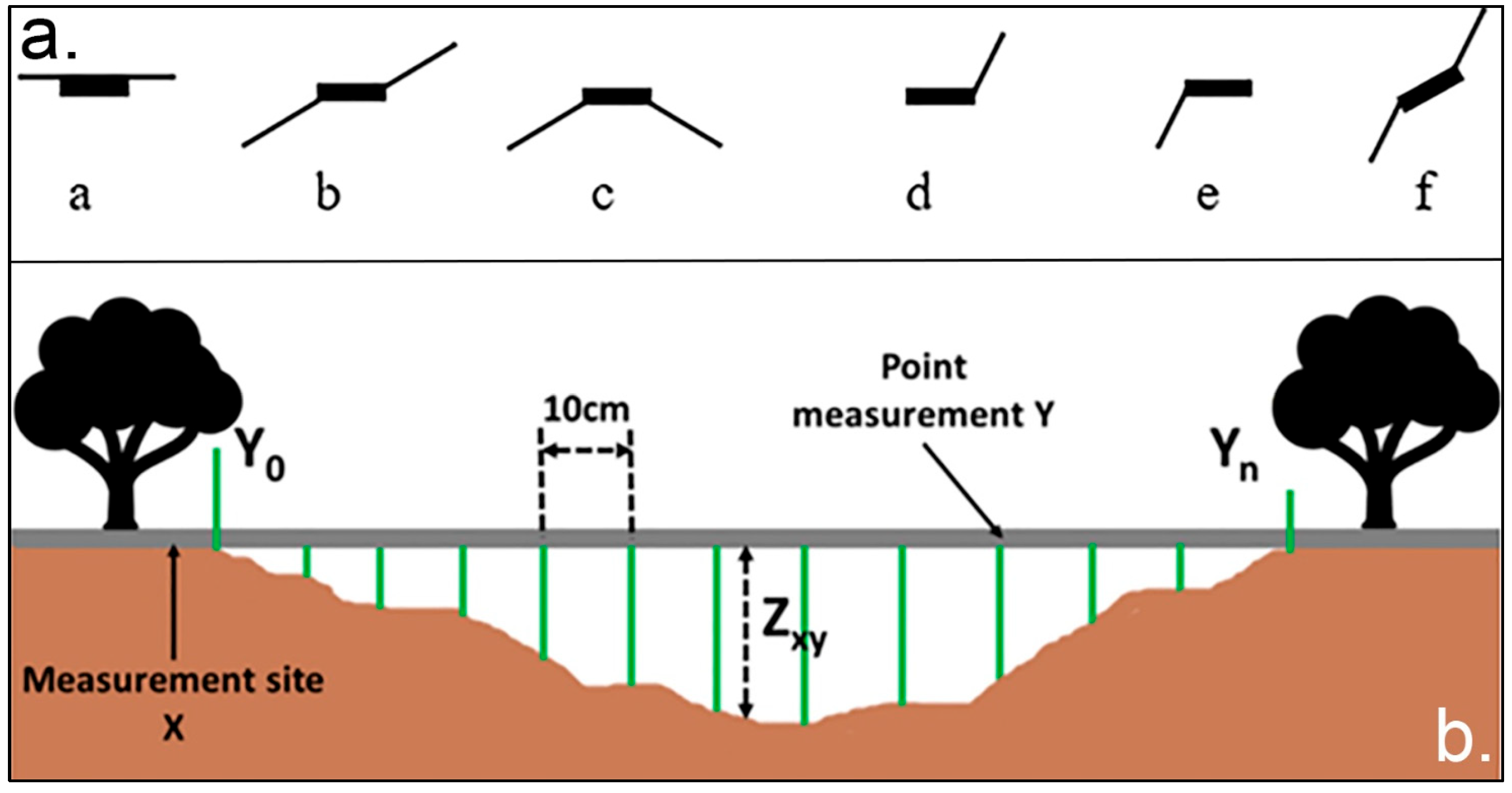
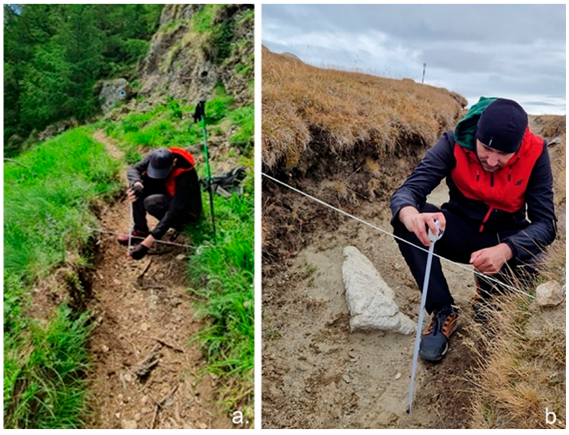
3. Materials and Methods
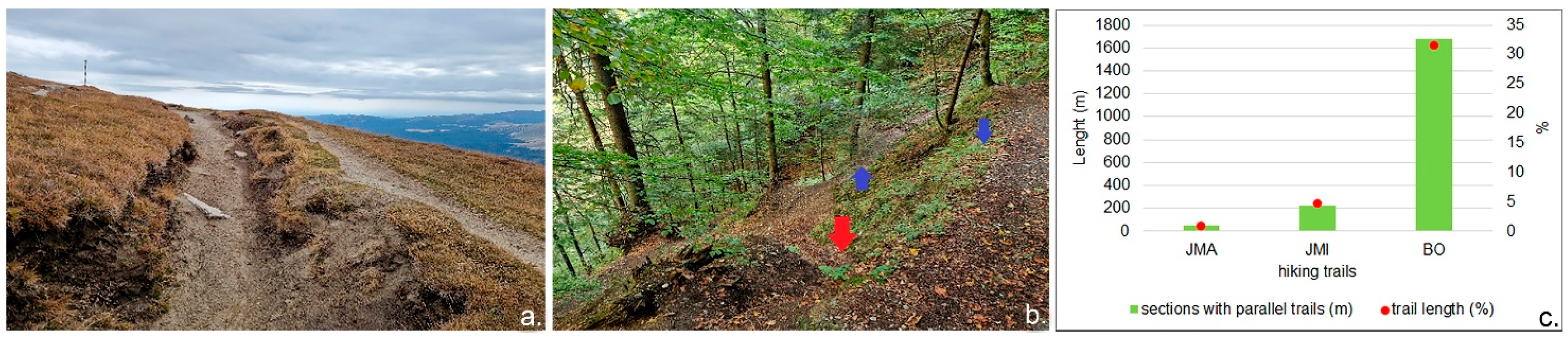
4. Results
4.1. Morphometric Analysis
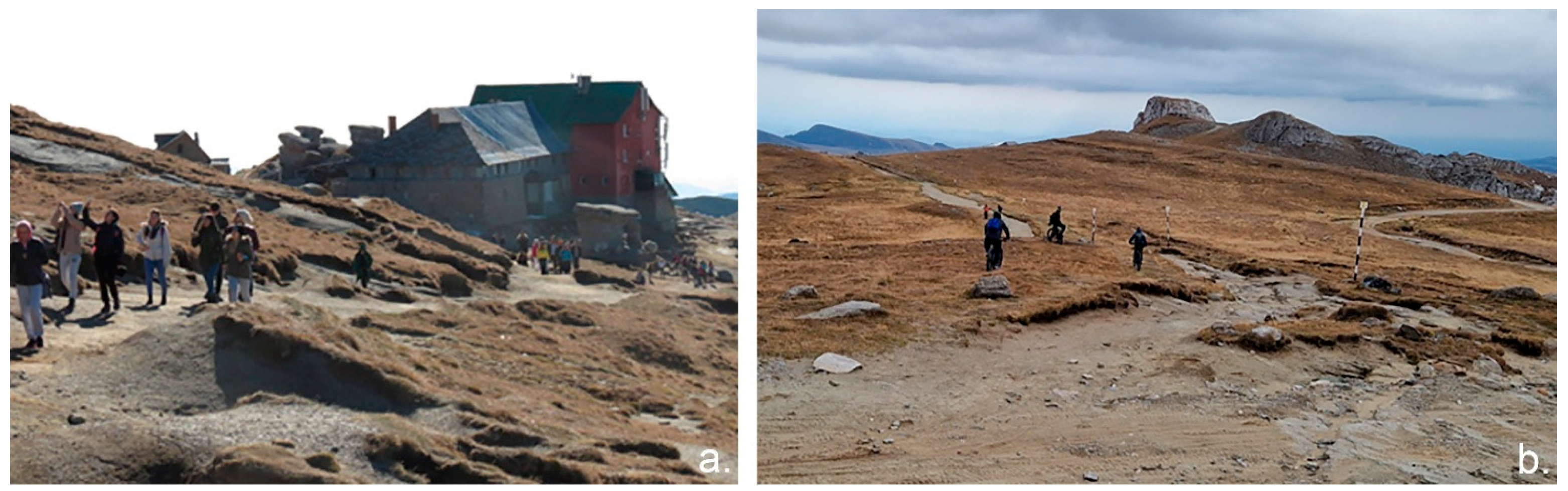
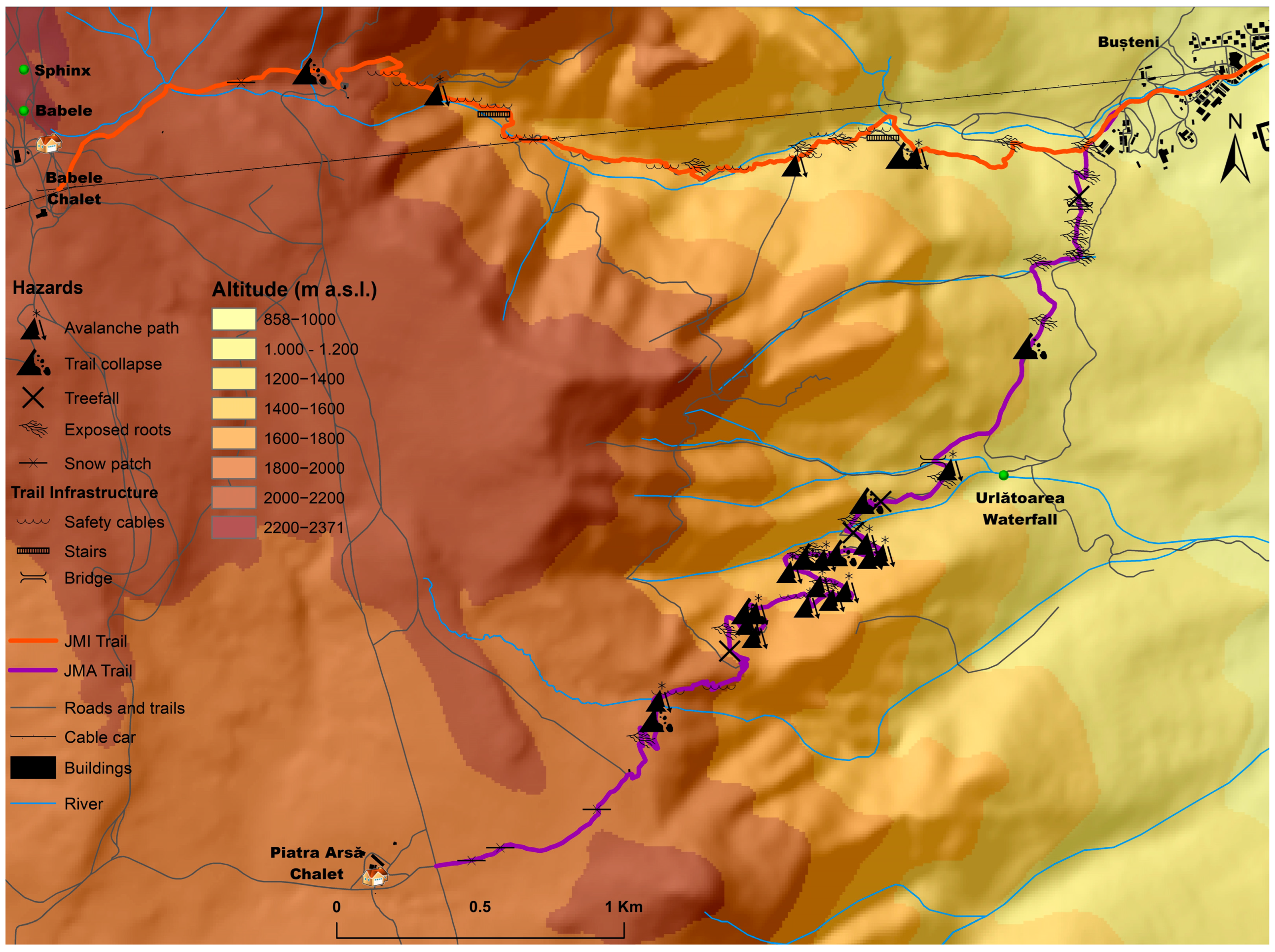
4.2. Hazards Associated with Hiking Trails
5. Discussion
6. Conclusions
Author Contributions
Funding
Data Availability Statement
Acknowledgments
Conflicts of Interest
Abbreviations
| JMI | Jepii Mici Trail |
| JMA | Jepii Mari Trail |
| BO | Babele Chalet–Omu Peak Trail |
References
- Boller, F.; Hunziker, M.; Conedera, M.; Elsasser, H.; Krebs, P. Fascinating remoteness: The dilemma of hiking tourism development in peripheral mountain areas. Mt. Res. Dev. 2010, 30, 320–331. [Google Scholar] [CrossRef]
- Janočkova, J.; Koščova, M.; Jablonska, J. The ability of tourist natural trails to resist tourism load and possibilities for reducing the environmental impacts: Case study of the Slovak Paradise National Park (Slovakia). Ekologia 2015, 34, 281–292. [Google Scholar] [CrossRef]
- Marion, J.L.; Leung, Y.F. Trail resource impacts and an examination of alternative assessment techniques. J. Park Recreat. Adm. 2001, 19, 17–37. [Google Scholar]
- Marion, J.L.; Leung, Y.F. Assessing and Understanding Trail Degradation: Results from Big South Fork National River and Recreational Area; National Park Service, Final Research Report; U.S. Department of the Interior, U.S. Geological Survey: Tallahassee, FL, USA, 2006; p. 84. [Google Scholar] [CrossRef]
- Tomczyk, A.M.; Ewertowski, M. Planning of recreational trails in protected areas: Application of regression tree analysis and geographic information systems. Appl. Geogr. 2013, 40, 129–139. [Google Scholar] [CrossRef]
- Tomczyk, A.M.; Ewertowski, M. Quantifying short-term surface changes on recreational trails: The use of topographic surveys and ‘digital elevation models of differences’ (DODs). Geomorphology 2013, 183, 58–72. [Google Scholar] [CrossRef]
- Fidelus-Orzechowska, J.; Gorczyca, E.; Bukowski, M.; Krzemień, K. Degradation of a protected mountain area by tourist traffic: Case study of the Tatra National Park, Poland. J. Mt. Sci. 2021, 18, 2503–2519. [Google Scholar] [CrossRef]
- Salesa, D.; Terol, E.; Cerdà, A. Soil erosion on the “El Portalet” mountain trails in the Eastern Iberian Peninsula. Sci. Total Environ. 2019, 661, 504–513. [Google Scholar] [CrossRef]
- Tomczyk, A.M. A GIS assessment and modelling of environmental sensitivity of recreational trails: The case of Gorce National Park, Poland. Appl. Geogr. 2011, 31, 339–351. [Google Scholar] [CrossRef]
- Salesa, D.; Cerdà, A. Soil erosion on mountain trails as a consequence of recreational activities. A comprehensive review of the scientific literature. J. Environ. Manag. 2020, 271, 110990. [Google Scholar] [CrossRef]
- Goeft, U.; Alder, J. Sustainable mountain biking: A case study from the Southwest of Western Australia. J. Sustain. Tour. 2001, 9, 193–211. [Google Scholar] [CrossRef]
- Leung, Y.-F.; Marion, J.L. Assessing trail conditions in protected areas: Application of a problem-assessment method in Great Smoky Mountains National Park, USA. Environ. Conserv. 1999, 26, 270–279. [Google Scholar] [CrossRef]
- Li, W.; Ge, X.; Liu, C. Hiking Trails and Tourism Impact Assessment In Protected Area: Jiuzhaigou Biosphere Reserve, China. Environ. Monit. Assess. 2005, 108, 279–293. [Google Scholar] [CrossRef] [PubMed]
- Meadema, F.; Marion, J.L.; Arredondo, J.; Wimpey, J. The influence of layout on Appalachian Trail soil loss, widening, and muddiness: Implications for sustainable trail design and management. J. Environ. Manag. 2020, 257, 109986. [Google Scholar] [CrossRef]
- Barros, A.; Gonnet, J.; Pickering, C. Impacts of informal trails on vegetation and soils in the highest protected area in the Southern Hemisphere. J. Environ. Manag. 2013, 127, 50–60. [Google Scholar] [CrossRef]
- Hill, W.; Pickering, C.M. Vegetation associated with different walking track types in the Kosciuszko alpine area, Australia. J. Environ. Manag. 2006, 78, 24–34. [Google Scholar] [CrossRef]
- Roovers, P.; Verheyen, K.; Hermy, M.; Gulinck, H. Experimental trampling and vegetation recovery in some forest and heathland communities. Appl. Veg. Sci. 2004, 7, 111–118. [Google Scholar] [CrossRef]
- Hill, W.; Pickering, C. Evaluation of Impacts and Methods for The Assessment of Walking Tracks in Protected Areas, 1st ed.; Cooperative Research Centre for Sustainable Tourism Pty Ltd.: Gold Coast, QLD, Australia, 2009; ISBN 9781921521775/9781921521782. [Google Scholar]
- Pelfini, M.; Santilli, M. Dendrogeomorphological analyses on exposed roots along two mountain hiking trails in the Central Italian Alps. Geogr. Ann. Ser. A Phys. Geogr. 2006, 88, 223–236. [Google Scholar] [CrossRef]
- Tomczyk, A.M.; Ewertowski, M.W. Recreational trails in the Poprad Landscape Park, Poland: The spatial pattern of trail impacts and use-related, environmental, and managerial factors. J. Maps 2016, 12, 1227–1235. [Google Scholar] [CrossRef]
- Bodoque, J.M.; Díez-Herrero, A.; Martín-Duque, J.F.; Rubiales, J.M.; Godfrey, A.; Pedraza, J.; Carrasco, R.M.; Sanz, M.A. Sheet erosion rates determined by using dendrogeomorphological analysis of exposed tree roots: Two examples from Central Spain. Catena 2005, 64, 81–102. [Google Scholar] [CrossRef]
- Bodoque, J.M.; Ballesteros-Cánovas, J.A.; Rubiales, J.M.; Perucha, M.Á.; Nadal-Romero, E.; Stoffel, M. Quantifying Soil Erosion from Hiking Trail in a Protected Natural Area in the Spanish Pyrenees. Land Degrad. Dev. 2017, 28, 2255–2267. [Google Scholar] [CrossRef]
- Ciapała, S.; Adamski, P.; Zielonka, T. Tree ring analysis as an indicator of environmental changes caused by tourist trampling —A potential method for the assessment of the impact of tourists. Geochronometria 2014, 41, 392–399. [Google Scholar] [CrossRef]
- Jula, M.; Voiculescu, M. Assessment of the mean erosion rate using dendrogeomorphological approaches on exposed roots along hiking and biking trails in the Bucegi Mountains, Romanian Carpathians. Catena 2022, 217, 106435. [Google Scholar] [CrossRef]
- Jula, M.; Voiculescu, M. Assessment of the Annual Erosion Rate along Three Hiking Trails in the Făgăraș Mountains, Romanian Carpathians, Using Dendrogeomorphological Approaches of Exposed Roots. Forests 2022, 13, 1993. [Google Scholar] [CrossRef]
- Matulewski, P.; Buchwal, A.; Zielonka, A.; Wrońska-Wałach, D.; Čufar, K.; Gärtner, H. Trampling as a major ecological factor affecting the radial growth and wood anatomy of Scots pine (Pinus sylvestris L.) roots on a hiking trail. Ecol. Indic. 2021, 121, 107095. [Google Scholar] [CrossRef]
- Mihai, B.; Reynard, E.; Werren, G.; Savulescu, I.; Sandric, I.; Chitu, Z. Impacts of tourism on geomorphological processes in the Bucegi Mountains in Romania. Geogr. Helv. 2009, 64, 134–147. [Google Scholar] [CrossRef]
- Clius, M.; Teleucă, A.; David, O.; Moroşanu, A. Trail Accessibility as a Tool for Sustainable Management of Protected Areas: Case Study Ceahlău National Park, Romania. Procedia Environ. Sci. 2012, 14, 267–278. [Google Scholar] [CrossRef]
- Ovreiu, A.B.; Bărsoianu, I.A.; Comănescu, L.; Nedelea, A. Assessing the accesibility of relief for tourism activities. Case study—Cozia Massif (Southern Carpathians, Romania). Geoj. Tour. Geosites 2018, 22, 509–523. [Google Scholar]
- Tîrlă, L.; Matei, E.; Cuculici, R.; Vijulie, I.; Manea, G. Digital Elevation Profile: A Complex Tool for the Spatial Analysis of Hiking Trails. J. Environ. Tour. Anal. 2014, 2, 48–66. [Google Scholar]
- Gratton, M.; Morin, S.; Germain, D.; Voiculescu, M.; Ianăş, A. Tourism and Natural Hazards in Bâlea Glacial Area Valley, Făgăraş Massif, Romanian Carpathians. Carpathian J. Earth Environ. Sci. 2015, 10, 19–32. [Google Scholar]
- Lucaciu, G.; Marinău, M.A.; Ștef, M.; Cristea, D.I.; Olszewski-Strzyzowski, D.J. Tourism in Apuseni Mountains (Romania)—A technical proposal. Balt. J. Health Phys. Act. 2021, 13, 169–177. [Google Scholar] [CrossRef]
- Desculțu Grigore, M.I.; Niță, A.; Drăguleasa, I.A.; Mazilu, M. Geotourism, a New Perspective of Post-COVID-19-Pandemic Relaunch through Travel Agencies—Case Study: Bucegi Natural Park, Romania. Sustainability 2024, 16, 985. [Google Scholar] [CrossRef]
- Olariu, B. Metode de Analiză a Calității Mediilor Montane în Ariile Protejate. Studiu de Caz: Parcul Natural Bucegi. Ph.D. Thesis, University of Bucharest, Bucharest, Romania, 2019. [Google Scholar]
- Jula, M.R.; Voiculescu, M. Ten-Year History of Hiking Accidents/Incidents in the Bucegi Mountains–Southern Carpathians, Romanian Carpathians. Rev. Hist. Geogr. Toponomast. 2024, XIX, 9–28. [Google Scholar]
- Velcea, V. Masivul Bucegi—Studiu Geomorfologic; Academiei R.P.R.: Bucharest, Romania, 1961. [Google Scholar]
- Brandolini, P.; Pelfini, M. Mapping geomorphological hazards in relation to geotourism and hiking trails. In Mapping Geoheritage; Regolini-Bissig, G., Reynard, E., Eds.; Institut Degéographie: Lausanne, The Switzerland, 2010; pp. 31–45. [Google Scholar]
- Marion, J.L.; Wimpey, J. Assessing the influence of sustainable trail design and maintenance on soil loss. J. Environ. Manag. 2017, 189, 46–57. [Google Scholar] [CrossRef]
- Pickering, C.M.; Hill, W.; Newsome, D.; Leung, Y.F. Comparing hiking, mountain biking and horse riding impacts on vegetation and soils in Australia and the United States of America. J. Environ. Manag. 2010, 91, 551–562. [Google Scholar] [CrossRef]
- Forest Service Trail Accesibility Guidelines (FSTAG); USDA Forest Service, National Technology and Development Program: Missoula, MT, USA, 2013.
- National Design Parameters; USDA Forest Service: Missoula, MT, USA, 2016.
- Hasselbarth, W.; Vachowski, B.; Davies, M.A. Trail Construction and Maintenance Notebook; USDA Forest Service, Missoula Technology and Development Center: Missoula, MT, USA, 2007. [Google Scholar]
- Vias Martinez, J.; Ocaña Ocaña, C. Multicriteria evaluation by GIS to determine trail hiking suitability in a natural park. Bol. Asoc. Geogr. Esp. 2014, 66, 323–339. [Google Scholar]
- Yoda, A.; Watanabe, T. Erosion of mountain hiking trail over a seven-year period in Daisetsuzan National Park, central Hokkaido, Japan. In Wilderness Ecosystems, Threats, and Management; Cole, D.N., McCool, S.F., Borrie, W.T., O’Loghlin, J., Eds.; U.S. Department of Agriculture, Forest Service, Rocky Mountain Research Station: Missoula, MT, USA, 2000; pp. 172–178. [Google Scholar]
- Smith, I.; Pickering, C.M. Assessing the Environmental Impacts, Condition and Sustainability of Mountain Biking Trails in an Urban National Park. Environ. Manag. 2025, 75, 793–805. [Google Scholar] [CrossRef]
- Bodoque, J.M.; Lucía, A.; Ballesteros, J.A.; Martín-Duque, J.F.; Rubiales, J.M.; Genova, M. Measuring medium-term sheet erosion in gullies from trees: A case study using dendrogeomorphological analysis of exposed pine roots in central Iberia. Geomorphology 2011, 134, 417–425. [Google Scholar] [CrossRef]
- Corona, C.; Lopez Saez, J.; Rovéra, G.; Stoffel, M.; Astrade, L.; Berger, F. High resolution, quantitative reconstruction of erosion rates based on anatomical changes in exposed roots at Draix, Alpes de Haute-Provence—Critical review of existing approaches and independent quality control of results. Geomorphology 2011, 125, 433–444. [Google Scholar] [CrossRef]
- Matulewski, P.; Buchwal, A.; Wronska-Walach, D.; Gartner, H. Radial growth changes in Scots pine (Pinus sylvestris L.) roots subjected to trampling erosion on a hiking trail in Brodnica Lakeland, NE Poland. In Proceedings of the Tree Rings in Archaeology, Climatology and Ecology, Bialowieza, Poland, 11–15 May 2016. [Google Scholar]
- Leung, Y.F.; Marion, J.L. Trail degradation as influenced by environmental factors: A state-of-the-knowledge review. J. Soil. Water Conserv. 1996, 51, 130–136. [Google Scholar] [CrossRef]


| Name/Code | Starting Point (Lat/Long) | Starting Altitude (m a.s.l.) | Arrival Altitude (m a.s.l.) | Vertical Drop (m) | Length (km) | Difficulty Level (According to HG 77/2003) * |
|---|---|---|---|---|---|---|
| Jepii Mici/JMI | 45°25°24′/31′31′31″ | 980 | 2206 | 1226 | 5.4 | difficult |
| Jepii Mari/JMA | 45°25°24′/31′31″31″ | 980 | 1950 | 970 | 6.8 | difficult |
| Babele–Omu Peak/BO | 45°25°24′/28′22″19″ | 2206 | 2507 | 301 | 6.1 | medium |
| Attribute | Classification | Implications |
|---|---|---|
| Trail Width [18,37,39,40,41,42] | A: ≤50 cm | Does not allow walking side-by-side, complicating surpassing or intersecting other tourists. In sectors adjacent to steep slopes, this can lead to accidents. |
| B: 50–100 cm | Barely accommodates side-by-side walking, and the risk of accidents is still increased near steep slopes. | |
| C: 100–150 cm | Moderate width. | |
| D: 150–300 cm | Significant tourist flows, reduced vegetation cover, the potential emergence of quasi-parallel secondary trails, visual landscape degradation, and accelerated erosion. | |
| E: >300 cm | ||
| Trail Slope [40,41,42,43] | A: ≤6° | Generally accessible. |
| B: 6–12° | Accessible when the substrate is solid. | |
| C: 12–25° | Medium difficulty; infrastructure and safety features are recommended. Slopes greater than 30% (≈17°) may be perceived as obstacles by tourists. | |
| D: 25–40° | Steep gradients and escarpments typical of semi-wild and wild areas, located on long and difficult trails, meant for well-trained and equipped tourists, as is the case of JMI and JMA trails. To safely approach such gradients, additional structures such as cables, ladders, and bridges are necessary, but their extent is limited in favor of nature conservation. | |
| E: 40° | ||
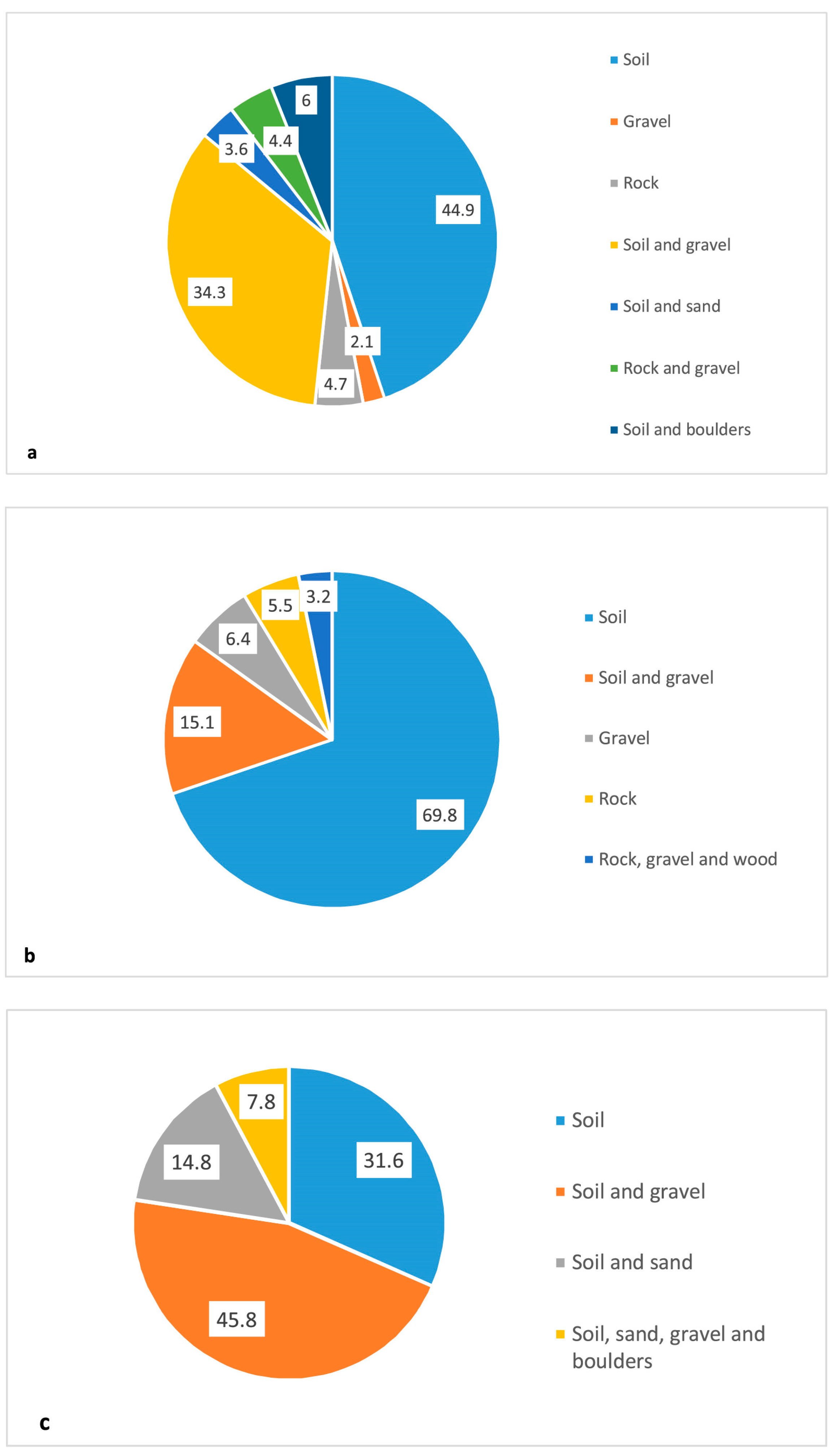
| Substrate Type [7] | Soil, gravel, rock, wood, etc. | Relevant for estimating trail difficulty and choosing appropriate equipment to prevent slip-related accidents, especially during or after rain showers. Additionally, the substrate can accelerate or limit erosion triggered by tourists. |
| Trail Form in Relation to Terrain [37] | See Figure 3a | Helps tourists in making informed trail choices suited to personal interests and physical preparedness, ultimately reducing the number of mountain rescue calls. This analysis can also aid authorities responsible for trail management when planning new routes or assessing existing ones, to avoid monotonous or excessively challenging trails where possible. |
| Trail configuration relative to the landforms [7] | Ridge, slope, or valley floor | Can accelerate erosion caused by tourist traffic and expand degraded areas near trails or limit it in the case of narrow ridges. |
| Trail and Geoecological Area | Number of Morphologically Homogeneous Sections | Average Length of Sections (m) | Average Width of Sections (cm) | Average Slope of Sections (°) | Maximum Trail Width (cm) |
|---|---|---|---|---|---|
| JMI—alpine | 20 | 93 | 111 | 21 | 230 |
| JMI—forested | 53 | 52.6 * | 87 * | 26.2 * | 200 * |
| JMA—alpine | 30 | 57.9 | 93 | 17.7 | 325 |
| JMA—forested | 60 | 57.9 | 51 | 19.4 | 130 |
| BO—alpine | 32 | 165.8 | 195 | 11.7 | 450 |
| Total/average/maximum in the alpine area | 82 | 105.6 | 133 | 16.8 | 450 |
| Total/average/maximum in the forested area | 113 | 55.3 | 69 | 22.8 | 200 |
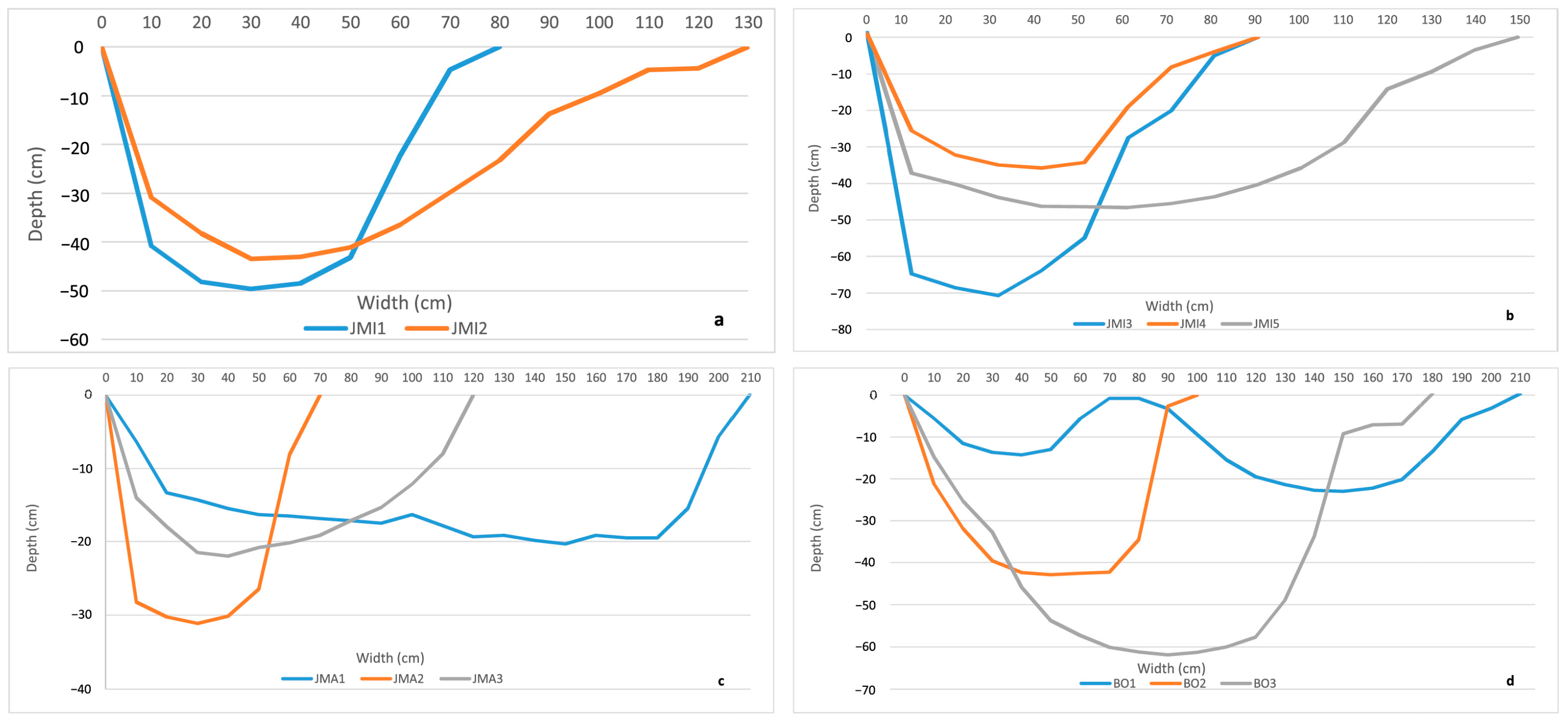
| Cross-Section Code | Vegetation Zone | Measured Distance (m) | Average Trail Area (cm2) | Average Volume of Displaced Soil (m3/m) | Average Slope (°) |
|---|---|---|---|---|---|
| JMI Trail | |||||
| JMI1 | Forested | 5 | 2572.5 | 0.26 | 16.5 |
| JMI2 | Forested | 7 | 3187.1 | 0.31 | 16 |
| JMI3 | Tree line | 5 | 3755 | 0.38 | 32.5 |
| JMI4 | Alpine | 5 | 1941 | 0.2 | 9 |
| JMI5 | Alpine | 5 | 4817.5 | 0.48 | 7 |
| JMA Trail | |||||
| JMA1 | Alpine | 5 | 3260 | 0.34 | 2 |
| JMA2 | Tree line | 5 | 1543.7 | 0.16 | 19 |
| JMA3 | Forested | 5 | 1883.3 | 0.18 | 16 |
| BO Trail | |||||
| BO1 | Alpine | 5 | 2455 | 0.24 | 7 |
| BO2 | Alpine | 5 | 3000 | 0.29 | 3 |
| BO3 | Alpine | 5 | 6980 | 0.69 | 12.5 |
Disclaimer/Publisher’s Note: The statements, opinions and data contained in all publications are solely those of the individual author(s) and contributor(s) and not of MDPI and/or the editor(s). MDPI and/or the editor(s) disclaim responsibility for any injury to people or property resulting from any ideas, methods, instructions or products referred to in the content. |
© 2025 by the authors. Licensee MDPI, Basel, Switzerland. This article is an open access article distributed under the terms and conditions of the Creative Commons Attribution (CC BY) license (https://creativecommons.org/licenses/by/4.0/).
Share and Cite
Jula, M.R.; Voiculescu, M. Assessment of Trail Erosion Under the Impact of Tourist Traffic in the Bucegi Mountains, Romanian Carpathians. Environments 2025, 12, 223. https://doi.org/10.3390/environments12070223
Jula MR, Voiculescu M. Assessment of Trail Erosion Under the Impact of Tourist Traffic in the Bucegi Mountains, Romanian Carpathians. Environments. 2025; 12(7):223. https://doi.org/10.3390/environments12070223
Chicago/Turabian StyleJula, Mihai Radu, and Mircea Voiculescu. 2025. "Assessment of Trail Erosion Under the Impact of Tourist Traffic in the Bucegi Mountains, Romanian Carpathians" Environments 12, no. 7: 223. https://doi.org/10.3390/environments12070223
APA StyleJula, M. R., & Voiculescu, M. (2025). Assessment of Trail Erosion Under the Impact of Tourist Traffic in the Bucegi Mountains, Romanian Carpathians. Environments, 12(7), 223. https://doi.org/10.3390/environments12070223