Article

Ecological Analysis and Opportunities for Enhancement of the Archaeological Landscape: The Vascular Flora of Seven Archaeological Sites in Greece

1
Laboratory of Floriculture and Landscape Architecture, Department of Crop Science, Agricultural University of Athens, Iera Odos 75, 11855 Athens, Greece
2
Laboratory of Ecology and Environmental Sciences, Department of Crop Science, Agricultural University of Athens, Iera Odos 75, 11855 Athens, Greece
3
Laboratory of Agronomy, Department of Crop Science, Agricultural University of Athens, Iera Odos 75, 11855 Athens, Greece
*
Author to whom correspondence should be addressed.
Environments 2024, 11(1), 16; https://doi.org/10.3390/environments11010016
Submission received: 28 October 2023 / Revised: 16 December 2023 / Accepted: 14 January 2024 / Published: 16 January 2024

Abstract

:
Spontaneous plants are an integral part of the archaeological landscape. The indigenous vegetation of the archaeological landscape can play a significant role in preserving the atmosphere of a place, as well as an additional element for education and recreation. Spontaneous vegetation was recorded in seven archaeological sites around Greece. Field surveys were conducted over two vegetative seasons, spanning spring and autumn, and data were gathered from both the surfaces of the monuments and the open field areas adjacent to these monuments. Therophytes were dominant on and around monuments across all sites throughout both the spring and autumn recording seasons. The three most abundant botanical families, in terms of species, found within the archaeological sites were Fabaceae, Poaceae, and Asteraceae. Based on the calculation of species diversity and evenness indices, it appeared that the sites exhibited high values during the spring period. The cluster and principal component analyses revealed that plant species tend to form clusters associated with the hosting archaeological sites, while the archaeological sites create variations that concern the species growing within them. The above is particularly significant as it implies that each archaeological site possesses a distinct and unique floristic identity, which can be utilized as an additional layer for education and enjoyment, enhancing the economic sustainability of these sites.

1. Introduction

Archaeological sites are commonly colonized by spontaneous vegetation. The colonization by vascular plants, in the case of monuments and archaeological sites, begins after their abandonment or, more commonly, after their excavation and the establishment of the final ground levels. The Mediterranean climate is characterized by annual rainfall ranging between 400–1500 mm, mild winters with temperatures rarely dropping below 0 °C, and particularly dry summers. The period of lowest rainfall is during the summer when temperatures are at their highest. This creates intense dry and hot periods of varying durations [1].
Due to these conditions, in Mediterranean archaeological sites, drought-resistant species with an annual biological cycle (therophytes) tend to predominate during the initial stages of colonization of the monuments and archaeological sites [2]. Therophytes exhibit significant seasonal variations, growing rapidly and abundantly in the spring or autumn and then disappearing. As the colonization process progresses, therophytes are later replaced by perennial, drought-resistant species [1,3].
The succession of biocommunities continues until they are replaced by biocommunities, which are mature, more stable, and well-adapted to the climate and substrate in which they develop, known as climax communities. Nevertheless, in the presence of stress factors, such as steep substratum slopes that do not allow soil accumulation, as seen in the case of vertical surfaces on monuments, the formation of such stable biocommunities becomes unfeasible [2]. Only populations of a few species, which are less stable and have less developed composition and structure, can be established [4].
Furthermore, various interventions to control weeds, such as cutting and herbicides applied at archaeological sites, hinder the succession of colonization into more mature biocommunities with perennial species, leading to an increase in annual species [2,3,5].
The plant species that colonize the ancient remains originate from the broader surroundings of the monuments [2] and possess morphological and physiological characteristics that enable them to survive in hostile environments. These adaptations include seed production capable of reaching small gaps between structures, primarily aided by wind and birds. These plants are also characterized by seeds capable of germinating with minimal moisture, short biological cycles, the presence of agametic reproduction organs such as runners and rhizomes, exceptional drought resistance, deep-root systems, and the ability to grow in crevices [6,7].
The vascular flora is an integral part of the archaeological landscape [5,8,9,10], where “In spring, fresh grass and colorful wildflowers bestow beauty upon the ancient stones” [11]. Indeed, as early as the 19th century, the aesthetic value of ruins was highly regarded, and the growth of plants on them was considered to enhance the picturesque quality of the landscape, emphasizing the passage of time [12]. The collective perception of the landscape of archaeological sites, which includes architectural ruins and spontaneously growing flora, is likely linked to the descriptions of explorers and naturalists from the 17th to 19th centuries, who discovered and studied the remains of ancient civilizations, around the Mediterranean basin, as well as the richness of nature. These travelers were captivated by the monuments and their surrounding environment, and they imbued them with an aesthetic dimension [13]. These landscapes bear the imprint of cultural influences, possibly preserved over time, and are shaped by the interplay of nature and human actions, while maintenance and management may aim to retain the historical value of the site.
Today, managing cultural heritage is impossible without considering the natural landscape in which it is situated as an opportunity to unify the natural and built environment [5,8], as the harmonious integration of monuments into their natural surroundings improves their aesthetic integration [14]. The distinctive flora of the Mediterranean basin is intertwined with the ancient monuments, as these structures draw inspiration from the intricacies of nature. The most well-known and characteristic example is the representation of the acanthus leaf (Acanthus spinosus L.) in Corinthian capitals. Furthermore, there are numerous examples of the use of plants during ancient times in everyday life, worship, mythology, and medicine, and such plants are still found today growing naturally in archaeological sites [15].
The above can be utilized within the framework of enhancing an archaeological site [5]. Contemporary theory on the comprehensive protection and management of monuments, as articulated through International Charters, describes the inseparable connection between a monument and the landscape in which it resides [8]. The Venice Charter [16] defines that the concept of a monument not only encompasses the architectural work but also the location that bears witness to a unique culture. It goes on to state that monument preservation entails conserving its immediate environment, from which it cannot be separated. The Charter for the Interpretation and Presentation of Cultural Heritage [17] proclaims the interconnectedness with society, the enhancement of educational influence, and the respect for the authenticity of the place. In the same year (2008), the Quebec Declaration for the Preservation of the Spirit of Place (genius loci) [18] defined that the spirit of a place includes both tangible and intangible cultural assets, as well as the natural and spiritual elements that give meaning, value, emotion, and mystery to a place.
In this enhanced context, the indigenous vegetation of the archaeological landscape can play a significant role in preserving the atmosphere of a place (genius loci), as well as an additional element for education and recreation [5]. Especially in the case of archaeological parks, a term used in recent years to describe a designed landscape that narrates elements related to cultural and natural heritage [19], the value of species protection (biodiversity studies) is also considered [8] as well as their educational value as museological context, connected to the history of the site [5,10].
Furthermore, it has been proposed that archaeological sites could function as green spaces, as they are usually located in areas of exceptional natural beauty, occupy large areas, and are protected and preserved for the benefit of conserving the rich native flora [5,10,20]. This unintended conservation effect highlights the interconnectedness between human history and natural ecosystems, emphasizing the broader impact of archaeological sites on biodiversity conservation [21]. Thus, in the modern world, where heightened vigilance for environmental protection issues is necessary, archaeological sites could also serve as biodiversity protection zones [8,22].
With an enhanced focus on the role of vegetation in the archaeological landscape, the aim of this study was to perform an ecological analysis of the vascular flora of archaeological sites around Greece, to understand the biodiversity of archaeological sites and assess the potential opportunities for the development of museological content, by the inclusion of native plants.

2. Materials and Methods

2.1. Sites Description

To document the spontaneous vegetation in archaeological sites, seven locations scattered across the country were carefully selected based on their geographical positions. The objective was to record the plant species surrounding the monuments and archaeological areas, considering the diverse climatic conditions of Greece. During the site selection process, a thorough evaluation of numerous potential sites took place. Factors such as ease of access, the granting of access from relevant authorities, and the size of the site were critical in shaping the final choice. Larger area sites were prioritized to ensure a more comprehensive and representative ecological analysis. The selected sites were the Ancient Agora of Athens (urban area, central Greece), Amfiareion at Oropos (peri-urban area, central Greece), Kolona on Aegina Island (coastal, rural area, central Greece), Ancient Messene (rural area, southern Greece), Nekromanteion of Acheron (rural area, western Greece), the Ancient Forum of Thessaloniki (urban area, northern Greece) and Early Christian Amfipolis (rural area, northern Greece) (Figure 1 and Figure 2). Climatic data concerning the selected sites are presented in Table 1.
Within the archaeological sites surveyed for this study, an annual weed management protocol is being carried out by the Archaeological Authority of each site on and around monuments in order to control the overgrowing vegetation. This involves the use of mechanical tools (such as string trimmers) to control weeds around monuments in the open surfaces and hand weeding to remove weeds growing directly on the ruins (direct communication with supervisory personnel from relevant Archaeological Authorities).

2.2. Data Collection

Field surveys were conducted over two vegetative seasons, spanning the spring and autumn of 2012. Data were collected prior to the implementation of annual weed management protocols by the relevant authorities. In spring, the surveys were carried out at the Ancient Agora of Athens from March 26 to April 2, Kolona in Aegina from April 9 to 12, the Ancient Forum of Thessaloniki on April 23 and 24, the Early Christian Amfipolis from May 2 to 4, Ancient Messene from May 8 to 10, the Amfiareion at Oropos from May 15 to 25, and the Nekromanteion of Acheron from May 30 to June 1. In autumn, the surveys started at Kolona in Aegina on June 28 and 29, followed by the Ancient Forum of Thessaloniki on September 18 and 19, the Early Christian Amfipolis from September 20 to 22, the Ancient Messene from September 26 to 28, the Amfiareion at Oropos from November 2 to 7, the Nekromanteion of Acheron from November 13 to 16, and ended at the Ancient Agora of Athens from November 27 to December 4. Differences in field survey dates were based on the seasonal differences between sites.
Data were collected from both the surfaces of monuments and the open areas adjacent to these monuments. For data collection around the monuments, a systematic approach was adopted utilizing randomly positioned 50 by 50 cm sampling plots. The determination of the optimal number of these sampling plots was achieved through the utilization of a species accumulation curve. This curve plotted the accumulated number of species on the Y-axis against the number of sampling plots on the X-axis. Adequate sampling was indicated when the addition of new species diminished significantly after successive sampling plots, generally observable as the curve’s progression began to level off. The specific inflection point was estimated following the “10% rule”, where a point is reached at which a 10% increase in sampling area yields less than a 10% increase in the number of new species recorded [23]. Within each individual sampling plot, the coverage of each plant species was assessed using the Braun Blanquet scale [24].
Data from surfaces on the monuments were collected from randomly selected microsites, considering the variability described in the pertinent literature [6]: cavities at ground level, cavities on inclined surfaces, cavities between two types of building material, cavities in a vertical face of homogenous material, cavities on horizontal surfaces, cavities at the junction of vertical and horizontal surfaces, cavities where two vertical surfaces meet, a substrate formed on a horizontal porous surface, a substrate formed on ruined stonework, spaces between a wall and its stone façade and wall invaded by a rhizome of a plant in adjacent soil. Since the sampling sites on monuments varied significantly, quantitative data collection was not feasible, and instead, data collection was recorded as the presence or absence of plant species.
Overall, 50 vegetation samples were carried out in Athens Agora, 30 in Kolona, 40 in Thessaloniki Forum, 39 in Amfipolis, 29 in Messene, 34 in Amfiareio, and 35 in Nekromanteion during each vegetative season.
Samples were collected from each sampling plot or microsite plant, and the plant specimens were identified based on Flora Europaea [25].

2.3. Data Processing

For each plant sample, botanical families were organized based on APG IV for angiosperms, and plant life forms were classified according to Raunkiaer [26]. The participation percentages of botanical families and the participation percentages of biological forms were calculated. These forms included therophytes, hemicryptophytes, geophytes, chamaephytes and phanerophytes. Additionally, the relative abundance:
Pi = Ni/N
was calculated for each species within each individual location. In this context, Ni represents the total occurrences of the i species within each archaeological site, and N represents the total occurrences of all species throughout the entire archaeological site.
Several key metrics were employed to assess biodiversity at each site comprehensively. Based on the number of observed species (Sobs), the expected number of species (Se) was calculated through the application of the Jack Knife method [27]:
Se = Sobs + k(n − 1)/n.
Here, n denotes the count of releves, and k signifies the total count of distinct species within a pool of n releves. This species richness analysis was conducted utilizing data gathered from both the surfaces of monuments and the surrounding areas across all sites.
Furthermore, the relative abundance of species identified within sampling plots around monuments was used to calculate two biodiversity indices. The Simpson and the Shannon–Wiener species diversity indices were calculated [28]. An evenness index was also calculated [29]:
Ε = H′/lnSobs
where H′ is the Shannon–Wiener biodiversity index and Sobs is the number of observed species.
Cluster analysis was performed on data collected from surfaces on monuments, following the agglomerative hierarchical clustering method; principal component analysis was also conducted. To eliminate the effects of rare species, only very abundant species were used in both the cluster and principal component analyses. The abundant species were indicated by Hill’s index [25]:
N2 = 1/∑Pi2
where Pi is the relative abundance.
For the cluster analysis, different classification algorithms were employed: single linkage, complete linkage, average linkage, and Ward’s method, using the Euclidean distance, squared Euclidean distance, Bray Curtis, Kendall, and Chi-squared. For the cluster analysis of monuments, the squared Euclidean distance with complete linkage was finally employed, while for the cluster analysis of plant species the Bray Curtis coefficient was used with complete linkage.
For the principal component analysis, correlation coefficients including Pearson (n − 1), Pearson (n), Spearman, and Kendall were employed in conjunction with various principal component rotation methods: varimax, equamax, orthomax, quartimax, parsimax, and quartimin. The aim was to select the principal component plot that could best explain the highest percentage of data variability. Ultimately, for data interpretation, the Spearman method was chosen without axis rotation.
For the cumulative hierarchical clustering and the principal component analysis, the XLSTAT 2014 package (Addinsoft, New York, NY, USA) was used.

3. Results

3.1. Species Distribution to Biological Forms

Therophytes were dominant on and around monuments across all sites throughout both the spring and autumn recording seasons, according to the data analysis of species classification into biological forms. More particularly, therophytes made up 66.1% of the recorded species around monuments during spring across all sites and 41.2% during autumn (Table 2). Similarly, therophytes were dominant on architectural remains of the monuments, accounting for 55.4% of species during spring and 31.6% during autumn.
The percentage of hemicryptophytes, geophytes, and chamaephytes was notably lower. During the spring season, around monuments, the respective percentages were as follows: 23.0% hemicryptophytes, 5.7% geophytes, and 4.6% chamaephytes (Table 2). Similar results were obtained from the recordings around moments during autumn and on monuments across both recording periods. Phanerophytes were exceptionally scarce around monuments, 0.6%, and 1.3% during spring and autumn, respectively (Table 2). Contrarily, on ancient remains, phanerophytes were recorded at a higher rate of 12.0% and 23.2% during the spring and autumn periods, respectively.

3.2. Species Distribution to Botanical Families

Through the identification of taxa across the seven archaeological sites, a total of 67 botanical families were found. The three most abundant botanical families, in terms of the number of species, found within the archaeological sites were Fabaceae, Poaceae, and Asteraceae. The dominance of these families was evident on and around monuments during both spring and autumn. More specifically, during spring around monuments, the Fabaceae species predominated (21.0%), followed by Poaceae (20.6%) and Asteraceae (17.7%, Table 3). Contrarily, during the autumn period, the Asteraceae family was dominant (19.7%), followed by Poaceae (13.9%) and Fabaceae (5.8%). On monuments, during spring, the Poaceae family was dominant (16.9%), followed by Asteraceae (16.3%) and Fabaceae (14.4%, Table 3). During the autumn period, on monuments, species of the Asteraceae family were most abundant (17.6%), followed by Poaceae (10.8%) and Fabaceae (7.4%). Other botanical families comprised less than 5% of the plant species (Table 3).

3.3. Species Richness and Diversity Indices

Based on the data analysis of the species recorded on and around monuments and the calculation of observed species and species richness, it was found that the Amfiareion at Oropos, the Nekromanteion of Acheron, and Ancient Messene were the three richest areas in plant species, and the species richness of these sites was 152, 123, and 122 species respectively (Table 4). Contrarily, at the Ancient Forum of Thessaloniki, the Kolona Aegina, and the Early Christian Amfipolis, the species richness was lower, with 53, 64, and 90 species, respectively, while at the Ancient Agora of Athens, it was 95.
The diversity indices were calculated based on observations only around monuments, as obtaining homogenous samples was only feasible there. From the calculation of diversity and evenness indices, the sites exhibited high values during the spring period. More specifically, the Shannon–Wiener diversity index (H′), which typically ranges between values of 1.5 to 3.5 and rarely exceeds 4.5 [25], had a value of 2.36 in Kolona Aegina, 2.73 in the Ancient Agora of Athens, and 2.68 in the Nekromanteion of Acheron (Table 5). Similar values were observed in early Christian Amfipolis and Ancient Messene. Amfiareion presented the highest value of 3.42, while the Ancient Forum of Thessaloniki exhibited the lowest value of 1.61.
The Simpson diversity index (D), which ranges from 0 to 1 [26], also exhibited high values. In Amfiareion at Oropos, during spring, it had a value of 0.96, and in Amfipolis, it was 0.93 (Table 5). In the Ancient Agora of Athens, it was calculated at 0.90, while similar values were observed in the Nekromanteion, Messene, and Kolona. The lowest value of the Simpson index was found in the Ancient Forum of Thessaloniki at 0.68. The evenness index (E) also demonstrated high values in most areas, ranging from 0.79 in Amfipolis to 0.67 in Kolona, with the lowest value appearing in the Ancient Forum of Thessaloniki (0.53, Table 5).
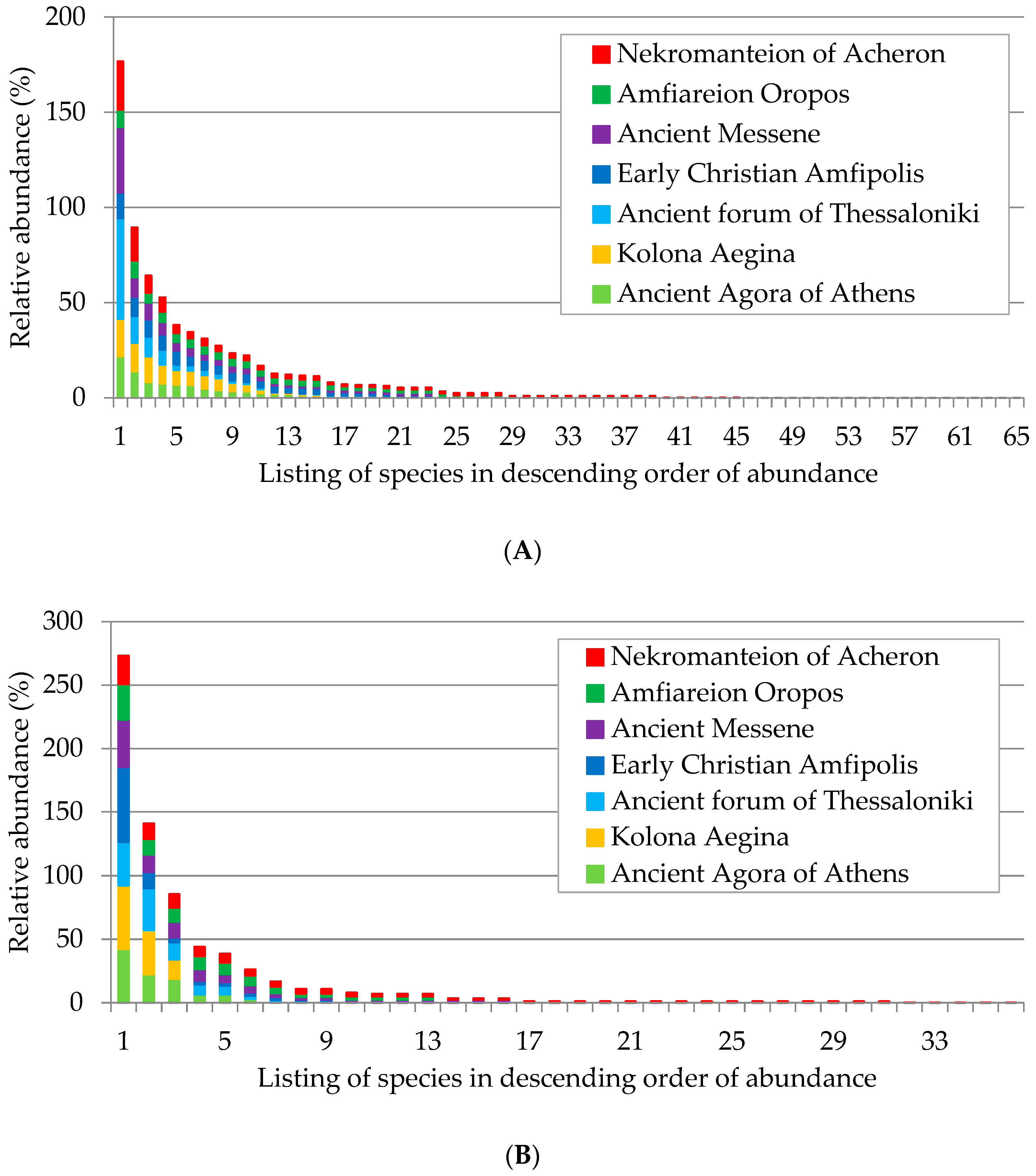
The Shannon–Wiener diversity index (H′) is sensitive to rare species, while the Simpson diversity index (D) depends on abundant species. As shown in the species abundance distribution diagram, higher values of the Shannon–Wiener index are observed in areas with many species of low abundance, such as Amfiareion at Oropos during the spring and Nekromanteion during the autumn, respectively. Similarly, areas with more abundant species exhibit high values of the Simpson index, such as Amfipolis and Amfiareion during the spring and Amfiareion during the autumn (Figure 3).

3.4. Cluster and Principal Component Analyses

Table 6 below presents the most abundant species growing on monument surfaces based on their relative abundance as calculated by the N2 index [25]. These species were included in the cluster and principal component analyses, the results of which are presented below.
The dendrogram resulting from the cluster analysis of monuments based on the abundant plant species growing on their surfaces is presented in Figure 4. Four clusters were identified based on the analysis: the first cluster includes Kolona and Amfiareion, the second cluster comprises only of Ancient Agora of Athens, the third cluster consists of Ancient Messene, Amfipolis, and Nekromanteion, and the fourth cluster represents the Ancient Forum of Thessaloniki.
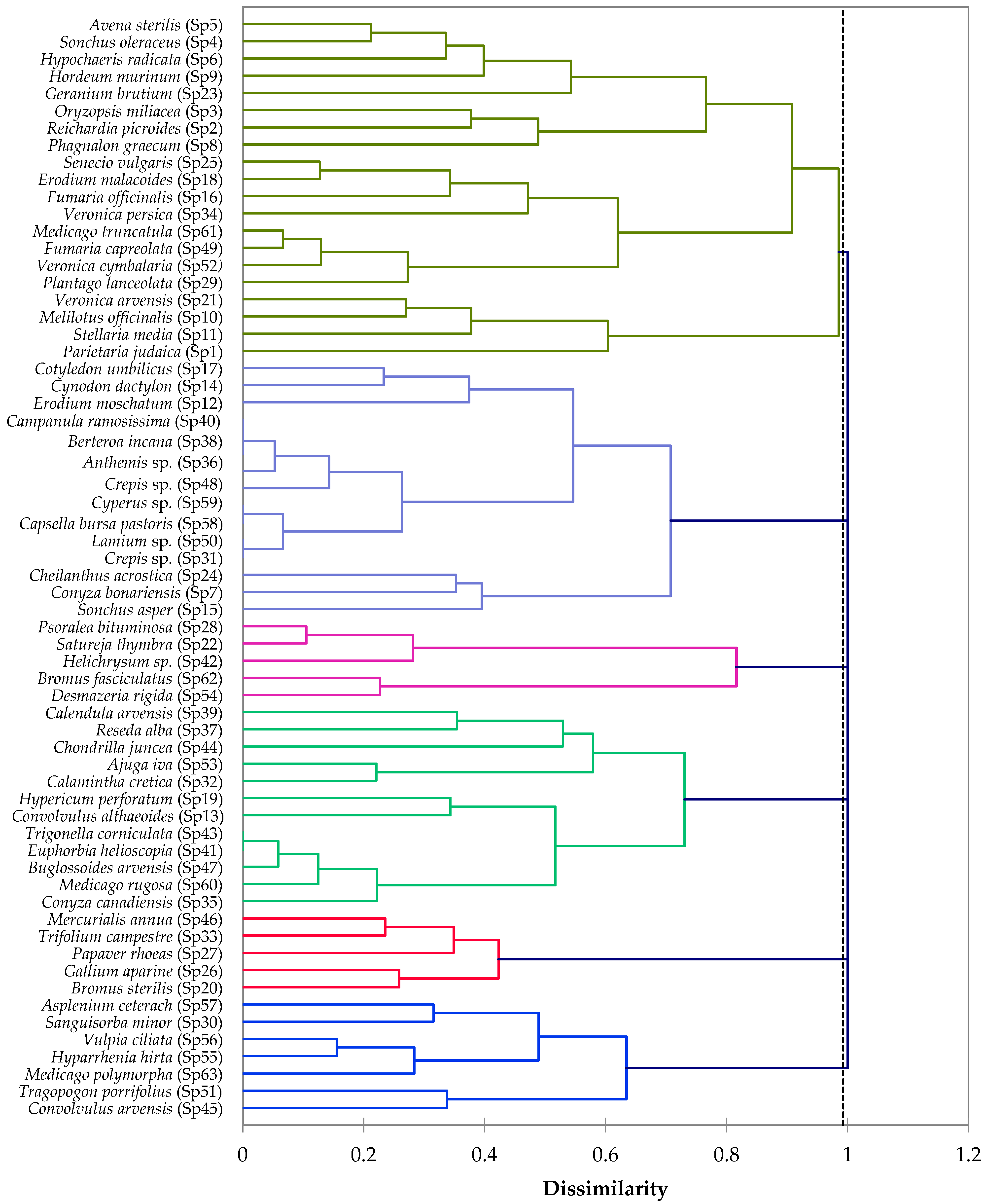
Based on the dendrogram resulting from the cluster analysis of plant species abundant on monuments, six groups emerged (Figure 5). The first group included species that were most common across the sites and were abundant in multiple locations. Among others, these included Parietaria judaica, abundant in six sites; Avena sterilis, abundant in seven sites; Sonchus oleraceus, abundant in six sites; and Oryzopsis miliaceae, abundant in five sites (Figure 5). The second group comprised species that were more abundant, primarily in Nekromanteion, with some being common in Messene, Amfiareion, and Amfipolis, such as Erodium moschatum, Cynodon dactylon, and Campanula ramassissima. The third group included species that were most dominant in Kolona, such as Convolvulus althaeoides, Hypericum perforatum, and Calendula arvensis. The fourth group encompassed species that were more abundant in Amfipolis and were common with the Ancient Agora of Athens, such as Bromus sterilis, Galium aparine, and Papaver rhoeas. The fifth group consisted of species dominant in Amfiareion, such as Satureja thymbra, Psoralea bituminosa, and Helichrysum sp. The last group included species dominant in Messene and Amfiareion, such as Sanguisorba minor, Hyparrhenia hirta, and Vulpia ciliata (Figure 5).
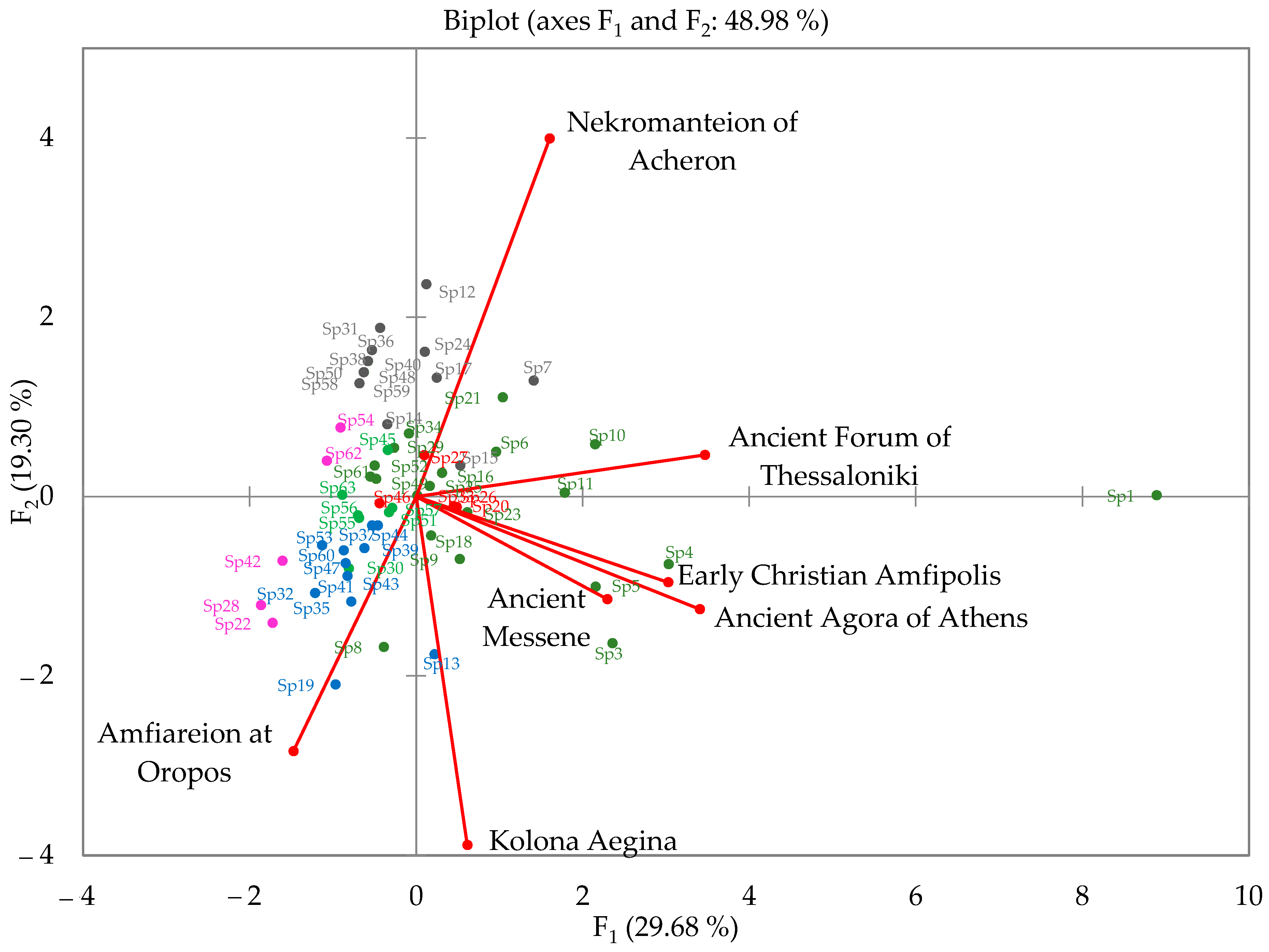
Figure 6 shows the biplot of the recorded species and the studied monuments on the palin of the two major principal components, F1 and F2, which explain 29.68% and 19.30%, respectively (and 48.98% in total) of the observed variability. The figure shows that the Ancient Agora of Athens, Amfipolis, and Messene sites exhibit a strong correlation among themselves and form a cluster, and, along with the Ancient Forum of Thessaloniki, contribute to the formation of the first axis, F1. Nekromanteion is strongly associated with axis F2. Kolona has a negative association with Nekromanteion and primarily contributes to the formation of axis F2, while Amfiareion, which also negatively relates to Nekromanteion, contributes to the formation of both axes F1 and F2.
Regarding the plant species, neighboring data points predispose to potential clustering and are indicative of the areas that create the nearby axes of variation. An analogy can be observed with the groups derived from the cluster analysis. Species from the second group, which were abundant in Nekromanteion, cluster together and characterize Nekromanteion, forming the nearby axis of variation, such as Anthemis sp., Campanula ramasissima, and Cotyledon umbilicus (shown in grey in Figure 6). Species from the third and fifth groups, identified from the cluster analysis as dominant in Kolona and Amfiareion, align along the axis of variation created by Kolona and Amfiareion. These include Convolvulus althaeoides, Hypericum perforatum, and Calamintha cretica (shown in blue and pink in Figure 6). Species from the first group, which contained the most common species among the areas and included those abundant in multiple places, exhibit different component values (shown in dark green in Figure 6). Species with the highest component values are associated with the variation axis F1, formed by the Ancient Agora of Athens, Amfipolis, Messene, and the Ancient Forum of Thessaloniki. These species include Oryzopsis miliaceae, Sonchus oleraceus, and Avena sterilis. Species from the first group with lower component values are associated with the axis created by Nekromanteion, such as Veronica cymbalaria, Plantago lanceolata, and Fumaria officinalis. The species from the fourth group, abundant in the Ancient Agora of Athens and Amfipolis, also exhibit smaller component values along the variation axis created by these areas, including Bromus sterilis, Galium aparine, and Papaver rhoeas (shown in red in Figure 6). Lastly, species from the sixth group, which were abundant in Messene and Amfiareion, relate to the axis created by Amfiareion, including Hyparrhenia hirta, Asplenium ceterach, and Sanguisorba minor (shown in bright green in Figure 6).

4. Discussion

The prevalence of therophytes in the studied archaeological sites suggests an early phase of colonization, aligning with previous findings that indicate therophytes’ dominance during the initial stages of colonization in Mediterranean warm and dry climates [5]. This trend might be linked to the application of weed control methods within archaeological sites, potentially obstructing the transition of colonization into more advanced biocommunities characterized by perennial species [2,3,20].
Within the archaeological sites surveyed for this study, an annual weed management protocol is being carried out on and around monuments. This involves hand weeding and mechanical tools. This practice appears to impede the natural evolution of the colonization process.
The occurrence of phanerophytes on monuments appears to primarily stem from the dispersion of seeds of decorative species planted within the sites or cultivated species from the surrounding regions, as indicated previously in the pertinent literature [2,21]. For example, in the Ancient Agora of Athens, the recorded phanerophytes on the monuments included Lantana camara L., Laurus nobilis L., and Nerium oleander L.—all introduced to the site as decorative species during the 1950s [30]. In Ancient Messene, the observed phanerophytes on the monuments predominantly included fig trees (Ficus carica L.), which are cultivated around the site. In Amfipolis, lentisk (Pistacia lentiscus L.), which grows spontaneously in the surrounding area, was noted on the monuments. Additionally, Ailanthus altissima (Mill.) Swingle, a robustly invasive weed frequently documented in archaeological sites [2,8,10], was documented in both the Athens Agora and Amfipolis. Weed growth on monuments is managed through hand weeding (personal communication with supervisors from the relevant Archaeological Authorities). However, this approach appears to demonstrate limited efficacy against phanerophytes.
The distribution of species growing in archaeological sites into biological forms could provide insights into vegetation management strategies [5]. Different types of biological forms cause different types of problems on and around monuments. The explosive growth of therophytes on the open surfaces of archaeological sites around the monuments poses various problems, such as difficulties in maintenance and restoration work, visual obstruction of remains, challenges in visitor access, and the risk of fire, whereas the growth of plant species on monument surfaces mainly causes mechanical damage, and the severity is linked to the biological form, in the order Therophytes < Hemicryptophytes < Geophytes < Chamaephytes < Phanerophytes [31]. A thorough comprehensive of plant ecology is crucial for developing an effective weed control program. In contrast, weed suppression treatments, within archaeological sites, should be periodically repeated, aligning with the growth cycle of spontaneous species [32]. Intensive interventions can be applied in the immediate vicinity of monuments, while much milder interventions can be implemented in the remaining areas to protect biodiversity. For the interventions on monument remains, the removal of species in the order Therophytes < Hemicryptophytes < Geophytes < Chamaephytes < Phanerophytes is recommended to reduce application costs and protect the biodiversity of plant communities. The prevalence of therophytes in the archaeological sites guides the selection of vegetation control strategies that could include the application of flaming or soil solarization, both effective methods against annual weeds [33,34], or the establishment of meadows of species selected among those growing spontaneously as a more sustainable and visually enhancing alternative for landscape management [35].
The prevalence of Poaceae, Asteraceae, and Fabaceae families has been previously reported in archaeological sites around the Mediterranean basin [5,8,21] and may be attributed to the fact that species of these families are well-adapted for dispersal and resilience in disturbed environments, especially in dry and warm conditions.
The abundance of grasses (Poaceae) in disturbed environments has been associated with their durability and seed dispersal by ants, as many grass species rely on mesofauna for seed dispersal in nature [36]. Moreover, species such as wild oats (Avena sterilis L.), sterile brome (Bromus sterilis L.), and wild barley (Hordeum murinum L.) can sustain their populations in regions with limited rainfall through intrinsic reproduction, thanks to the mechanisms their seeds possess for “self-burial” in the soil. The seeds of these species can enter the soil and remain there until it rains [36]. Furthermore, the dominance of Asteraceae species is attributed to the dispersal mechanisms of their seeds (wind dispersal), which allows them to spread over long distances [36]. Lastly, the legumes (Fabaceae) have been observed to exhibit resistance to mowing and even benefit from it. Dupre and Diekman [37] found a positive correlation between the presence of legumes and grazing in grassland areas, which aligns with earlier studies [38,39]. In the surveyed archaeological sites, annual weed mowing is practiced (personal communication with supervisors from relevant Archaeological Authorities).
It has been supported that precipitation was the primary factor determining plant species richness [40]. Water availability is the key factor for species richness, especially in warm regions. The three areas with the highest plant species richness, Amfipolis, the Nekromanteion, and Messene, also have the highest annual precipitation and ombrothermic indices and the shortest dry thermic period during the summer. However, a simple linear regression analysis between the number of recorded species and the annual precipitation in each area did not show a significant relationship between the factors (R2 = 0.44, p = 0.1). Furthermore, the simple linear regression analysis between the number of species and the logarithm of the site area did not reveal a significant relationship (R2 = 0.003, p = 0.9), contrary to the expected relationship between species number and area.
The results clearly show that these sites have high diversity indices during the spring period. The high diversity of a biotic community is likely attributed to disturbance-related phenomena, aligning with the intermediate disturbance hypothesis proposed by Washington [29]. Intermediate disturbance is the key factor in maintaining high diversity, as high diversity represents an unstable intermediate phase in community evolution following a disturbance [41].
The high diversity of archaeological sites is likely attributed to the intermediate disturbance caused by annual interventions to control weeds involving hand weeding and mechanical tools. A positive correlation between grazing and species richness in meadows has been found [36,42,43,44,45]. Grazing appears to reduce the resilience of competitive species, favoring less competitive ones. Additionally, the creation of gaps allows species regeneration from seeds in the soil [37]. These findings align with the hypothesis of intermediate disturbance, where maximum species richness occurs at intermediate disturbance levels [41].
The cluster and principal component analyses reveal that plant species tend to cluster and characterize the archaeological sites they grow in, with the archaeological sites themselves contributing to the species found within them. This could be due to various factors such as soil composition, climate, or human activities associated with each site. The above is particularly significant as it implies that each archaeological site possesses a distinct and unique floristic identity. In other words, the combination of plant species found at a particular site is different from other sites, contributing to a specific botanical profile for each location. Overall, the findings imply that the plant life in archaeological sites is not random but shows a discernible pattern, and this pattern is influenced by the characteristics of the archaeological site itself. This information could be valuable for understanding the historical and ecological context of these sites based on their plant life.
Further, this element could be used in studies aimed at enhancing the historical landscape, as outlined by contemporary International Charters for the protection of cultural heritage. The International Charters protect the landscape surrounding monuments as part of the cultural heritage [16,17,18]. Furthermore, in archaeological parks, the central narrative incorporates all available elements of the area [8,10]. The establishment of an archaeological park can catalyze the development of both local and remote social centers while emphasizing the unique identity of the cultural heritage of a region and supporting economic sustainability [19].
Such an element could be the botanical identity of an archaeological site. More specific site management objectives could include the detailed assessment and botanical inventories of the existing vegetation, its historical context, and strategies for conservation. These botanical data can serve as a baseline for monitoring changes over time and guiding conservation efforts. Additional measures could involve the implementation of vegetation conservation zones to protect unique or endangered species. Additionally, educational programs should be established within archaeological parks that highlight the botanical significance of the site. These programs could include guided floral heritage trails focusing on the diverse flora of the sites, their historical uses, cultural significance, and conservation status.
Emphasizing the integration of botanical elements into the broader landscape design of archaeological sites ensures that vegetation is not viewed in isolation but as an integral part of the overall cultural and natural landscape. Incorporating such proposals can lead to the evolution of archaeological site management into a more holistic and multidimensional endeavor, where the botanical identity becomes a dynamic and integral part of the cultural and natural heritage narrative.
Greece boasts an astonishing variety of plant species, with one of the richest flora in Europe. Over 6000 species thrive in Greece, with 700 being endemic [9,43]. This diversity of vegetation has played a significant role in the emergence and evolution of civilizations, both ancient and modern, within our country. The ancient Greeks and Romans recognized more than 1000 plant species, and various botanical species participated in many aspects of life as sacred symbols, medicinal compounds, and sources of inspiration for art and mythology [15,46].

5. Conclusions

A notable prevalence of therophytes was evident, both on and around monuments. This can likely be attributed to the sites being in early colonization stages following excavation and/or the application of weed suppression methods (mechanical cutting with a string trimmer), which hinders the progression to more mature stages of colonization characterized by higher percentages of perennial species. The presence of therophytes in the archaeological sites guides the formulation of vegetation control strategies.
As revealed by the survey results, the dominant botanical families within the archaeological sites were Fabaceae, Poaceae, and Asteraceae. Their dominance is linked to their capacity for dispersion and persistence in challenging environments characterized by xerothermic conditions.
The analysis of diversity indices within the study sites revealed noteworthy levels of diversity, particularly during the spring season, characterized by an abundance of winter and early spring species. This phenomenon is plausibly linked to the intermediate disturbance caused by annual weed control interventions using string trimmers in the archaeological sites, which, in turn, contributes to increased biodiversity. These diversity indices are valuable tools for monitoring the biocommunities thriving within the archaeological sites.
The plant species recorded in these areas tend to cluster and distinguish the sites where they flourish. Simultaneously, archaeological sites introduce a distinct variation in the species inhabiting them. This distinctive botanical identity can play a crucial role in enhancing the significance of archaeological sites. Modern international conventions for monument preservation encompass not only the monuments themselves but also their immediate surroundings, while archaeological parks endeavor to showcase both their cultural and natural wealth. The unique floral character of archaeological sites can be harnessed as an additional layer for education and enjoyment, contributing to the economic sustainability of these sites.

Author Contributions

Conceptualization, E.K., M.P., C.S. and G.E.; methodology, E.K., M.P., C.S. and G.E.; software, C.S.; validation E.K., M.P., C.S. and G.E.; formal analysis, C.S.; investigation, E.K., M.P. and G.E.; resources, M.P.; data curation, E.K. and C.S.; writing—original draft preparation, E.K.; writing—review and editing, M.P. and C.S.; visualization, E.K.; supervision, M.P.; project administration, M.P.; funding acquisition, M.P. All authors have read and agreed to the published version of the manuscript.

Funding

The research program was co-financed by Greece and the European Union under the aegis of the Education and Lifelong Learning Operational Program, NSRF 2007-2013 MIS: 380237.

Data Availability Statement

The data presented in this study are available on request from the corresponding author.

Acknowledgments

This research was part of a larger-scale research program of the Agricultural University of Athens entitled Thalis-ARCHEOSCAPE-Integrated management of vegetation at archaeological sites to protect the monument and enhance the historical landscape. We would like to thank the Ephorates of Prehistorical and Classical Antiquities for their excellent cooperation during this program.

Conflicts of Interest

The authors declare no conflict of interest. The funders had no role in the design of the study, in the collection, analyses, or interpretation of data, in the writing of the manuscript, or in the decision to publish the results.

References

  1. Caneva, G.; Pacini, A. Problems of biodeterioration. In Plant Biology for Cultural Heritage. Biodeterioration and Conservation; The Getty Conservation Institute: Los Angeles, CA, USA, 2008; pp. 222–237. [Google Scholar]
  2. Motti, R.; Bonanomi, G. Vascular plant colonization of four castles in southern Italy: Effects of substrate bioreceptivity, local environment factors and current management. Int. Biodeterior. Biodegrad. 2018, 133, 26–33. [Google Scholar] [CrossRef]
  3. Cicinelli, E.; Benelli, F.; Bartoli, F.; Traversetti, L.; Caneva, G. Trends of plant communities growing on the Etruscan tombs (Cerveteri, Italy) related to different management practices. Plant Biosyst.—Int. J. Deal. All Asp. Plant Biol. 2020, 154, 158–164. [Google Scholar] [CrossRef]
  4. Caneva, G.; Ceschin, S. Ecology of biodeterioration. In Plant Biology for Cultural Heritage; The Getty Conservation Institute: Los Angeles, CA, USA, 2008; pp. 35–58. [Google Scholar]
  5. Caneva, G.; Benelli, F.; Bartoli, F.; Cicinelli, E. Safeguarding natural and cultural heritage on Etruscan tombs (La Banditaccia, Cerveteri, Italy). Rend. Fis. Acc. Lincei 2018, 29, 891–907. [Google Scholar] [CrossRef]
  6. Lisci, M.; Monte, M.; Pacini, E. Lichens and higher plants on stone: A review. Int. Biodeterior. Biodegrad. 2003, 51, 1–17. [Google Scholar] [CrossRef]
  7. Pacini, E.; Signorini, M. Vascular plants. In Plant Biology for Cultural Heritage; The Getty Conservation Institute: Los Angeles, CA, USA, 2008; pp. 87–96. [Google Scholar]
  8. Cicinelli, E.; Salerno, G.; Caneva, G. An assessment methodology to combine the preservation of biodiversity and cultural heritage: The San Vincenzo al Volturno historical site (Molise, Italy). Biodivers. Conserv. 2018, 27, 1073–1093. [Google Scholar] [CrossRef]
  9. Ceschin, S.; Bartoli, F.; Salerno, G.; Zuccarello, V.; Caneva, G. Natural habitats of typical plants growing on ruins of Roman archaeological sites (Rome, Italy). Plant Biosyst. Int. J. Deal. All Asp. Plant Biol. 2016, 150, 866–875. [Google Scholar] [CrossRef]
  10. Minissale, P.; Trigilia, A.; Brogna, F.; Sciandrello, S. Plants and Vegetation in the Archaeological Park of Neapolis of Syracuse (Sicily, Italy): A Management Effort and also an Opportunity for Better Enjoyment of the Site. Conserv. Manag. Archaeol. Sites 2015, 17, 340–369. [Google Scholar] [CrossRef]
  11. Touloupa, E. Introductory note. In Proceedings of the Symposium on Spontaneous Vegetation in Archaeological Sites, Athens, Greece, 22–23 May 1998; Acropolis Friends Association: Athens, Greece, 1998; pp. 3–4. [Google Scholar]
  12. Pinna, D.; Salvadori, O. Processes of biodeterioration: General mechanisms. In Plant Biology for Cultural Heritage; The Getty Conservation Institute: Los Angeles, CA, USA, 2008; pp. 15–34. [Google Scholar]
  13. Zahos, K. The Spontaneous Flora in Archaeological Sites: The Greek Experience. In Proceedings of the Symposium on Spontaneous Vegetation in Archaeological Sites, Athens, Greece, 22–23 May 1998; Acropolis Friends Association: Athens, Greece, 1998; pp. 9–17. [Google Scholar]
  14. Stratou, F. Introductory note. In Proceedings of the Symposium on Spontaneous Vegetation in Archaeological Sites, Athens, Greece, 22–23 May 1998; Acropolis Friends Association: Athens, Greece, 1998; p. 5. [Google Scholar]
  15. Baumann, H. Greek Wild Flowers and Plant Lore in Ancient Greece; The Greek Foundation for the Protection of Nature: Athens, Greece, 1999; pp. 14–22; 169–192. [Google Scholar]
  16. Venice Charter for the Conservation and Restoration of Monuments and Sites; International Council on Monuments and Sites (ICOMOS): Venice, Italy, 1964.
  17. The ICOMOS Charter for the Interpretation and Presentation of Cultural Heritage Sites; International Council on Monuments and Sites (ICOMOS): Quebec, QC, Canada, 2008.
  18. Quebec Declaration on the Preservation of the Spirit of Place; International Council on Monuments and Sites (ICOMOS): Quebec, QC, Canada, 2008.
  19. Tsaravopoulos, A.; Fragou, G. Archaeological sites as self-sustained resources for economic regeneration: Towards the creation of living archaeological parks on the islands of kythera and antikythera. Conserv. Manag. Archaeol. Sites 2013, 15, 94–108. [Google Scholar] [CrossRef]
  20. Hosseini, Z.; Bartoli, F.; Cicinelli, E.; Lucchese, F. First floristic investigation in archaeological sites of Iran: Features and plant richness of the Pasargadae World Heritage Site. Plant Biosyst.—Int. J. Deal. All Asp. Plant Biol. 2023, 157, 605–621. [Google Scholar] [CrossRef]
  21. Croce, A.; Biagioli, A.; Bella, V.D.; Topi, C. Archaeological sites as refugia and conservation areas of native orchids a case study from Northern Campania. GIROS Orch. Spont. Eur. 2019, 62, 70–89. [Google Scholar]
  22. Heneidy, S.Z.; Al-Sodany, Y.A.; Bidak, L.M.; Fakhry, A.M.; Hamouda, S.K.; Halmy, M.W.A.; Alrumman, S.A.; Al-Bakre, D.A.; Eid, E.M.; Toto, S.M. Archeological Sites and Relict Landscapes as Refuge for Biodiversity: Case Study of Alexandria City, Egypt. Sustainability 2022, 14, 2416. [Google Scholar] [CrossRef]
  23. DeBerry, D.A. Vegetation Sampling Concepts for Compensatory Mitigation Sites. Wetl. Sci. Pract. 2020, 37, 174–182. [Google Scholar] [CrossRef]
  24. Braun-Blanquet, J. Plant Sociology. In The Study of Plant Communities, 1st ed.; McGraw-Hill: New York, NY, USA, 1932; p. 539. [Google Scholar]
  25. Tutin, T.G.; Heywood, V.H.; Burges, N.A.; Valentine, D.H.; Walters, S.M.; Webb, D.A. Flora Europea; Cambridge University Press: Cambridge, UK, 1993. [Google Scholar]
  26. Raunkiaer, C. The Life Forms of Plants and Statistical Plant Geography; Clarendon Press: Oxford, UK, 1934. [Google Scholar]
  27. Heltshe, J.; Forrester, N. Estimating species richness using the Jackknife procedure. Biometrics 1983, 39, 1–11. [Google Scholar] [CrossRef] [PubMed]
  28. Xu, S.; Bottcher, L.; Chou, T. Diversity in biology: Definitions, quantification and models. Phys. Biol. 2020, 17, 031001. [Google Scholar] [CrossRef] [PubMed]
  29. Washington, H. Diversity, biotic and similarity indices. A review with special relevance to aquatic ecosystems. Water Res. 1984, 18, 653–694. [Google Scholar] [CrossRef]
  30. Mauzy, G. Agora Excavations, 1931–2006: A Pictorial History; American School of Classical Studies at Athens: Athens, Greece, 2006. [Google Scholar]
  31. Motti, R.; Stinca, A. Analysis of the Biodeteriogenic Vascular Flora at the Royal Palace of Portici in Southern Italy. Int. Biodeterior. Biodegrad. 2011, 65, 1256–1265. [Google Scholar] [CrossRef]
  32. Caneva, G.; Nugari, M.; Salvadori, O. Methodological aspects of the treatments. In Plant Biology for Cultural Heritage; The Getty Conservation Institute: Los Angeles, CA, USA, 2008; pp. 309–311. [Google Scholar]
  33. Kanellou, E.; Economou, G.; Papafotiou, M.; Ntoulas, N.; Lyra, D.; Knezevic, S. Flame weeding at archaeological sites of the Mediterranean region. Weed Technol. 2017, 31, 396–403. [Google Scholar] [CrossRef]
  34. Kanellou, E.; Papafotiou, M.; Economou, G.; Ntoulas, N. Testing soil solarization as an alternative weed control method for archaeological sites of the Mediterranean region. Sustainability 2023, 15, 11324. [Google Scholar] [CrossRef]
  35. Kanellou, E.; Papafotiou, M.; Economou, G.; Paraskevopoulou, A.; Kartsonas, E.; Ntoulas, N. Response of sowed herbaceous forb mixtures suitable for aesthetic improvement and vegetation management at archaeological sites of the Mediterranean region. Ecol. Eng. 2021, 167, 106256. [Google Scholar] [CrossRef]
  36. Benvenuti, S. Weed dynamics in the Mediterranean urban ecosystem: Ecology, biodiversity and management. Weed Res. 2004, 44, 341–354. [Google Scholar] [CrossRef]
  37. Dupre, C.; Diekman, M. Differences in species richness and life history traits between grazed and abandoned grasslands in southern Sweden. Ecography 2001, 24, 275–286. [Google Scholar] [CrossRef]
  38. Noy-Meir, I.; Gutman, M.; Kaplan, Y. Responses of Mediterranean grassland plants to grazing and protection. J. Ecol. 1989, 77, 290–310. [Google Scholar] [CrossRef]
  39. Hadar, L.; Noy-Meir, I.P.A. The effect of shrub clearing and grazing on the composition of a Mediterranean plant community: Functional groups versus species. J. Veg. Sci. 1999, 10, 673–682. [Google Scholar] [CrossRef]
  40. Hawkins, B.; Field, R.; Cornell, H.V.; Currie, D.J.; Guegan, J.; Kaufman, D.M.; Kerr, J.T.; Mittelbach, G.G.; Oberdorff, T.; O’Brien, E.M.; et al. Energy, water and broad-scale geographic patterns of species richness. Ecology 2003, 84, 3105–3117. [Google Scholar] [CrossRef]
  41. Osman, R.W. The Intermediate Disturbance Hypothesis. In Encyclopedia of Ecology, 2nd ed.; Fath, B., Ed.; Elsevier: Amsterdam, The Netherlands, 2015; pp. 441–450. [Google Scholar] [CrossRef]
  42. Bakker, J.P.; de Leeuw, J.; Dijkema, K.S.; Leendertse, P.C.; Prins, H.H.T.; Rozema, J. Salt marshes along the coast of the Netherlands. Hydrobiologia 1993, 265, 73–79. [Google Scholar] [CrossRef]
  43. Tremont, R. Life history attributes of plants in grazed and ungrazed grasslands on the Northern Table grasslands of New South Wales. Aust. J. Bot. 1994, 42, 511–530. [Google Scholar] [CrossRef]
  44. Smith, R.; Rushton, S. The effects of grazing management on the vegetation of mesotrophic (meadow) grassland in Northern England. J. Appl. Ecol. 1994, 31, 13–24. [Google Scholar] [CrossRef]
  45. Petit, N.; Froend, R.; Ladd, P. Grazing in remnant woodland vegetation: Changes in species composition and life form groups. J. Veg. Sci. 1995, 6, 121–130. [Google Scholar] [CrossRef]
  46. Baumann, H. Plants on Ancient Greek Coins; Ilivaton: Athens, Greece, 2004. [Google Scholar]
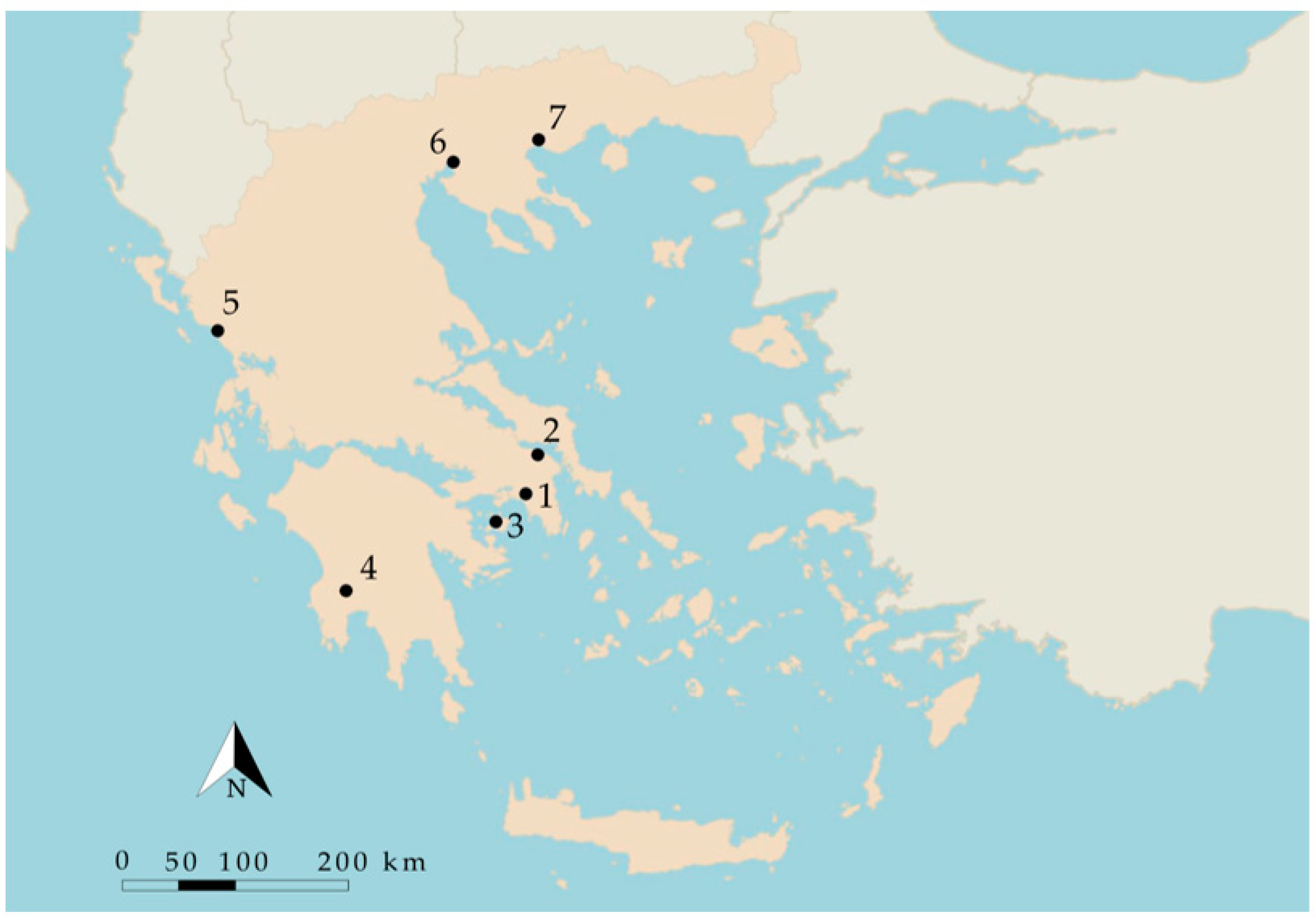
Figure 1. Location of the seven archaeological sites across Greece, where 1: Ancient Agora of Athens, 2: Amfiareion at Oropos, 3: Kolona on Aegina island, 4: Ancient Messene, 5: Nekromanteion of Acheron, 6: Ancient Forum of Thessaloniki and 7: Early Christian Amfipolis.
Environments 11 00016 g001
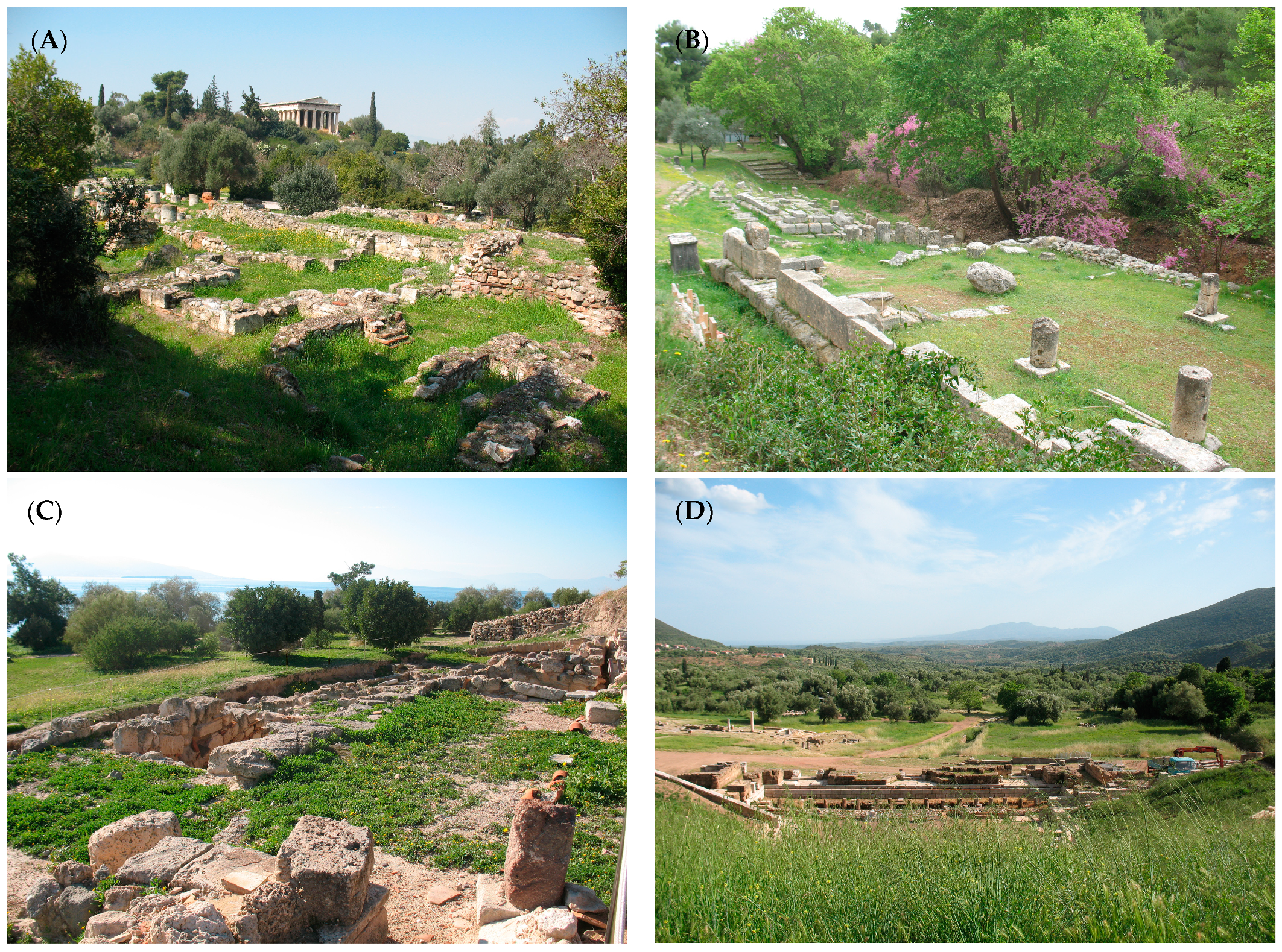
Figure 2. Partial view of each of the seven archaeological sites investigated in the study (A) Ancient Agora of Athens, (B) Amfiareion at Oropos, (C) Kolona on Aegina island, (D) Ancient Messene, (E) Nekromanteion of Acheron, (F) Ancient Forum of Thessaloniki and (G) Early Christian Amfipolis.
Environments 11 00016 g002aEnvironments 11 00016 g002b
Figure 3. Distribution of the abundance of species recorded around monuments: (A) During spring season recordings; (B) During autumn season recordings.
Environments 11 00016 g003
Figure 4. Dendrogram resulting from the cluster analysis of monuments, based on the abundant plant species growing on their surfaces.
Environments 11 00016 g004
Figure 5. Dendrogram resulting from the cluster analysis of the abundant plant species growing on monument surfaces. The numbered abbreviations SpN correspond to data points in Figure 5, which shows the principal components of the analysis of the abundant species recorded at the archaeological sites.
Environments 11 00016 g005
Figure 6. Scatterplot of the two principal components based on the factor loadings of the variables and the values of the samples as obtained from the principal component analysis. The numbered abbreviations SpN correspond to list of species in Figure 4.
Environments 11 00016 g006
Table 1. A comparison of mean monthly air temperature and precipitation between the selected archaeological sites (Hellenic National Meteorological Service, meteorological data for the period 1975–2004).
Archaeological Site *JanuaryFebruaryMarchAprilMayJuneJulyAugustSeptemberOctoberNovemberDecember
Air temperature (°C)
AAA9.369.5111.4715.6521.3126.0228.5527.8723.7919.0714.0010.58
AO8.148.710.914.0719.1824.4326.526.6822.5217.7112.69.93
KA10.299.8312.1515.7720.7825.4728.1227.4924.2719.4714.9711.35
AM9.279.0211.4214.6619.4824.2626.9726.0123.0418.2313.8610.48
NA8.438.6911.0213.7619.1223.0624.724.5321.617.4312.889.42
AFT5.186.629.3913.9919.9124.5926.7626.1521.7816.4510.776.16
ECA5.606.839.1714.0119.3123.8726.0725.2421.7416.4310.636.40
Precipitation (mm)
AAA37.2947.3855.7931.9217.877.067.307.219.1635.2351.0566.17
AO68.5149.5062.6733.6222.349.418.418.0415.0353.5390.34112.29
KA45.6837.8346.1531.1912.275.447.556.768.2437.1471.4074.37
AM129.4496.2980.7967.4629.128.028.5914.9335.7583.88159.16170.88
NA102.41113.9682.3569.2438.8817.6712.5519.0755.59113.98192.06173.51
AFT25.0038.8136.9943.7139.9129.0026.3524.0619.9226.4335.8540.00
ECA34.9037.2247.2737.1142.0434.6029.1119.6720.0341.9759.7663.47
* where AAA: Ancient Agora of Athens, KA: Kolona Aegina, AM: Ancient Messene, NA: Nekromanteion of Acheron, AFT: Ancient Forum of Thessaloniki, ECA: Early Christian Amfipolis.
Table 2. Distribution of species (%) into biological forms on and around monuments during spring and autumn recording seasons.
Around
Monuments Spring
Around
Monuments
Autumn
On
Monuments
Spring
On
Monuments
Autumn
Therophytes66.141.255.431.6
Hemicryptophytes23.036.222.327.4
Geophytes5.715.04.38.4
Chamaephytes4.66.36.09.4
Phanerophytes0.61.312.023.2
Table 3. Distribution of species (%) into botanical families, on and around monuments during spring and autumn recording seasons.
Botanical
Family
Around
Monuments Spring
Around
Monuments
Autumn
On
Monuments
Spring
On
Monuments
Autumn
Fabaceae21.05.814.47.4
Poaceae20.613.916.910.8
Asteraceae17.719.716.317.6
Plantaginaceae4.50.04.10.0
Geraniaceae3.90.04.10.0
Brassicaceae3.90.00.00.0
Malvaceae0.05.10.00.0
Lamiaceae0.04.44.14.1
Euphorbiaceae0.04.40.00.0
Moraceae0.00.00.04.1
Urticaceae0.00.00.04.1
Other28.446.740.151.9
Table 4. Species richness as the observed (Sobs) and the expected (Se) number of the species, as calculated through the application of the Jack Knife method [27], recorded on and around monuments during spring and autumn recording seasons.
Archaeological SiteSobsSe
Amfiareion Oropos124152
Nekromanteion of Acheron98123
Ancient Messene92122
Ancient Agora of Athens7795
Early Christian Amfipolis7290
Kolona Aegina5964
Ancient Forum of Thessaloniki5341
Table 5. Diversity indices based on recordings around monuments, during spring and autumn.
Index
SpringAutumn
Archaeological Site S * H′ D Ε S H′ D Ε
Ancient Forum of Thessaloniki 21 1.61 0.68 0.53 10 1.56 0.74 0.68
Kolona Aegina 33 2.36 0.89 0.67 3 1.00 0.61 0.91
Ancient Messene 48 2.50 0.85 0.65 29 2.08 0.81 0.62
Nekromanteion of Archeron 54 2.68 0.88 0.67 39 2.84 0.91 0.78
Ancient Agora of Athens 43 2.73 0.90 0.72 7 1.48 0.73 0.76
Early Christian Amfipolis 38 2.89 0.93 0.79 28 1.65 0.63 0.50
Amfiareion Oropos 82 3.42 0.96 0.78 26 2.27 0.86 0.70
* where S: number of observed species, H′: Shannon–Wienner diversity index, D: Simpson index, E: Evenness index.
Table 6. The relative abundance of the most abundant species recorded on monuments.
Archaeological Site AAA *AFTAM AOECAKA NASum of Sites
SpeciesRelative Abundance
Parietaria judaica L.8.3917.717.010.0013.563.527.077.28
Reichardia picroides (L.) Roth9.010.002.557.690.009.050.004.63
Oryzopsis miliacea (L.) Asch. & Schweinf.12.420.003.181.360.002.010.673.68
Sonchus oleraceus L.4.043.135.100.004.524.523.373.47
Avena sterilis L.3.731.043.821.365.652.512.022.93
Hypochaeris radicata L.4.041.040.000.451.692.513.702.31
Conyza bonariensis (L.) Cronquist0.933.135.100.000.560.004.041.84
Phagnalon graecum Boiss. & Heldr.4.350.000.003.170.003.020.001.84
Hordeum murinum L.2.480.001.270.001.694.021.351.70
Melilotus officinalis (L.) Lam.2.1718.750.000.000.000.000.001.70
Stellaria media (L.) Vill.2.179.381.270.003.390.000.001.63
Erodium moschatum (L.) L’Hér.0.310.000.640.450.560.006.061.50
Convolvulus althaeoides L.0.000.000.000.004.526.530.001.43
Cynodon dactylon (L.) Pers.0.000.001.272.261.130.003.371.29
Sonchus asper (L.) Hill0.000.006.370.900.000.002.361.29
Fumaria officinalis L.4.971.040.000.000.000.000.671.29
Cotyledon umbilicus Britten1.240.001.270.001.130.003.371.23
Erodium malacoides (L.) L’Hér.3.732.080.000.000.002.010.001.23
Hypericum perforatum L.0.000.000.001.810.007.040.001.23
Bromus sterilis L.3.110.000.000.003.950.000.001.16
Veronica arvensis L.0.3112.500.000.000.000.001.351.16
Satureja thymbra L.0.930.000.006.330.000.000.001.16
Geranium brutium Gasp.2.171.042.550.002.260.000.001.09
Cheilanthes acrostica (Balb.) Tod.0.000.002.550.000.000.004.041.09
Senecio vulgaris L.3.732.080.000.000.000.500.341.09
Gallium aparine L.1.240.000.640.005.080.000.000.95
Papaver rhoeas L.0.310.000.000.003.950.501.350.88
Psoralea bituminosa L.0.000.000.005.880.000.000.000.88
Plantago lanceolata L.2.800.000.000.000.000.001.010.82
Sanguisorba minor Scop.0.000.003.183.170.000.000.000.82
Crepis sp. 0.000.000.000.000.000.004.040.82
Calamintha cretica (L.) Lam.0.000.000.002.260.003.020.000.75
Trifolium campestre Schreb.0.310.001.270.453.390.000.340.75
Veronica persica Poir.1.553.130.000.000.000.001.010.75
Conyza canadiensis (L.) Cronquist0.000.000.000.000.005.530.000.75
Anthemis sp. 0.000.000.000.000.000.003.370.68
Reseda alba L.1.860.000.000.000.002.010.000.68
Berteroa incana (L.) DC.0.000.000.000.000.000.003.030.61
Calendula arvensis L0.620.000.640.000.003.020.000.61
Campanula ramosissima Sm.0.000.000.000.000.000.003.030.61
Euphorbia helioscopia L.0.000.000.000.000.004.520.000.61
Helichrysum sp. 0.000.000.004.070.000.000.000.61
Trigonella corniculata (L.) L.0.000.000.000.000.004.520.000.61
Chondrilla juncea L.0.000.000.000.002.262.010.000.54
Convolvulus arvensis L.0.620.001.910.000.000.001.010.54
Mercurialis annua L.0.000.000.000.903.390.000.000.54
Buglossoides arvensis (L.) I. M. Johnst.0.000.000.000.000.004.020.000.54
Crepis sp. 0.000.000.000.000.000.002.690.54
Fumaria capreolata L.2.480.000.000.000.000.000.000.54
Lamium sp.0.000.000.000.000.000.002.690.54
Tragopogon porrifolius L.0.620.001.910.000.561.010.000.54
Veronica cymbalaria Bodard2.170.000.000.000.000.000.340.54
Ajuga iva (L.) Schreb.0.000.000.001.360.002.010.000.48
DDesmazeria rigida (L.) Tutin0.000.000.000.900.000.001.680.48
Hyparrhenia hirta (L.) Stapf.0.000.002.551.360.000.000.000.48
Vulpia ciliata Dumort.0.000.001.911.360.560.000.000.48
Asplenium ceterach L.0.000.003.820.450.000.000.000.48
Capsella bursa subsp. pastoris (L.) Medik.0.000.000.000.000.000.002.360.48
Cyperus sp. 0.000.000.000.000.000.002.360.48
Medicago rugosa Desr.0.000.000.000.000.003.520.000.48
Medicago truncatula Gaerth.2.170.000.000.000.000.000.000.48
Bromus fasciculatus C. Presl0.000.000.001.360.000.001.010.41
Medicago polymorpha L.0.000.001.270.900.000.000.000.27
* where AAA: Ancient Agora of Athens, KA: Kolona Aegina, AM: Ancient Messene, NA: Nekromanteion of Acheron, AFT: Ancient Forum of Thessaloniki, ECA: Early Christan Amfipolis.
Disclaimer/Publisher’s Note: The statements, opinions and data contained in all publications are solely those of the individual author(s) and contributor(s) and not of MDPI and/or the editor(s). MDPI and/or the editor(s) disclaim responsibility for any injury to people or property resulting from any ideas, methods, instructions or products referred to in the content.