Thermal Effects of Magmatism on Surrounding Sediments and Petroleum Systems in the Northern Offshore Taranaki Basin, New Zealand


Abstract
1. Introduction
- How does the magmatic intrusion affect the thermal maturation of the surrounding source rock?
- What is the sensitivity of the results to the shape and distribution of volcanic intrusion?
- What are the effects of a deep seated magmatic intrusion (e.g., magma chamber) in comparison to dikes and sills intruding the sedimentary sequence?
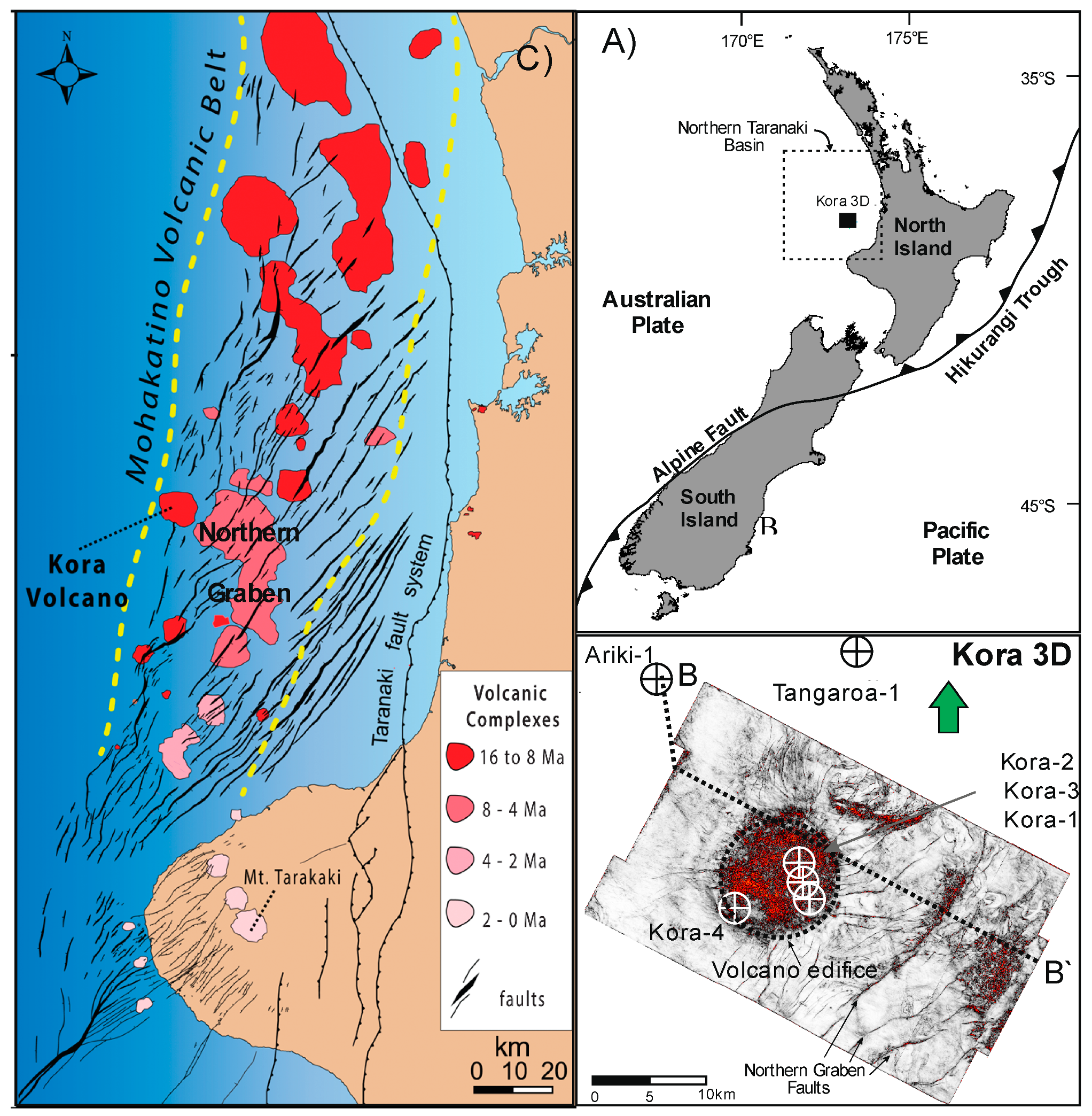
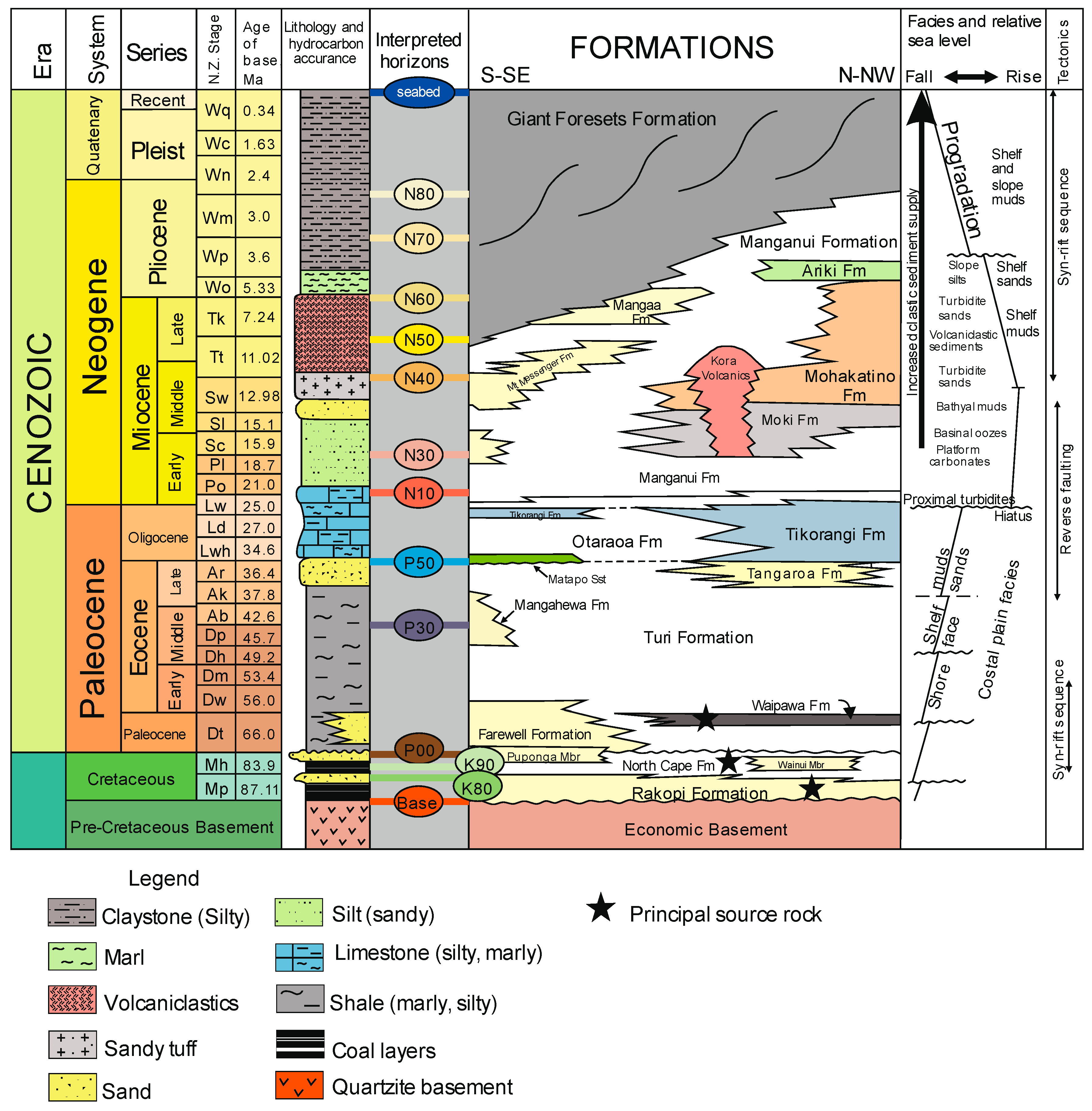
2. Geological Setting
3. Methods
3.1. Input Data
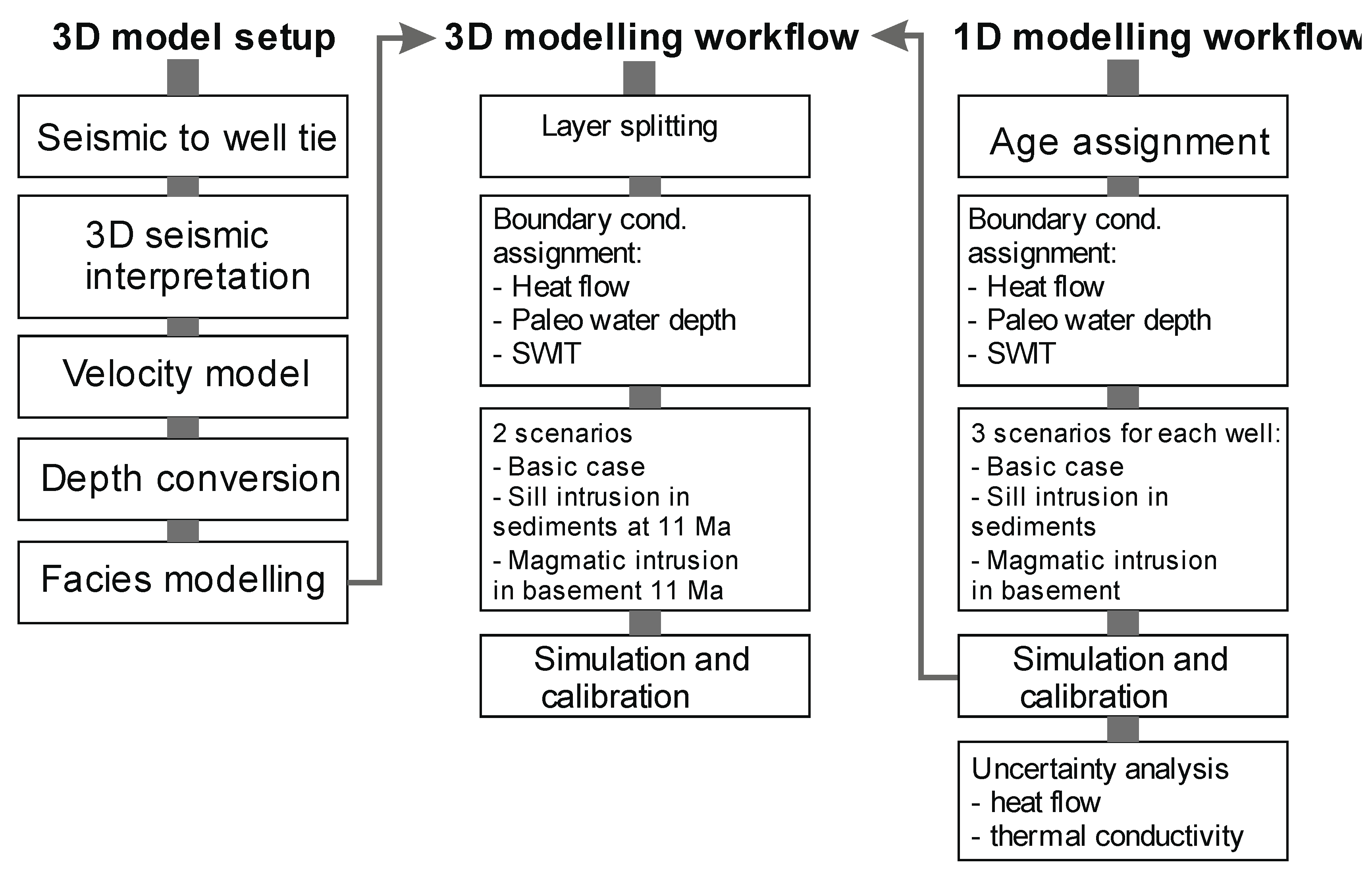
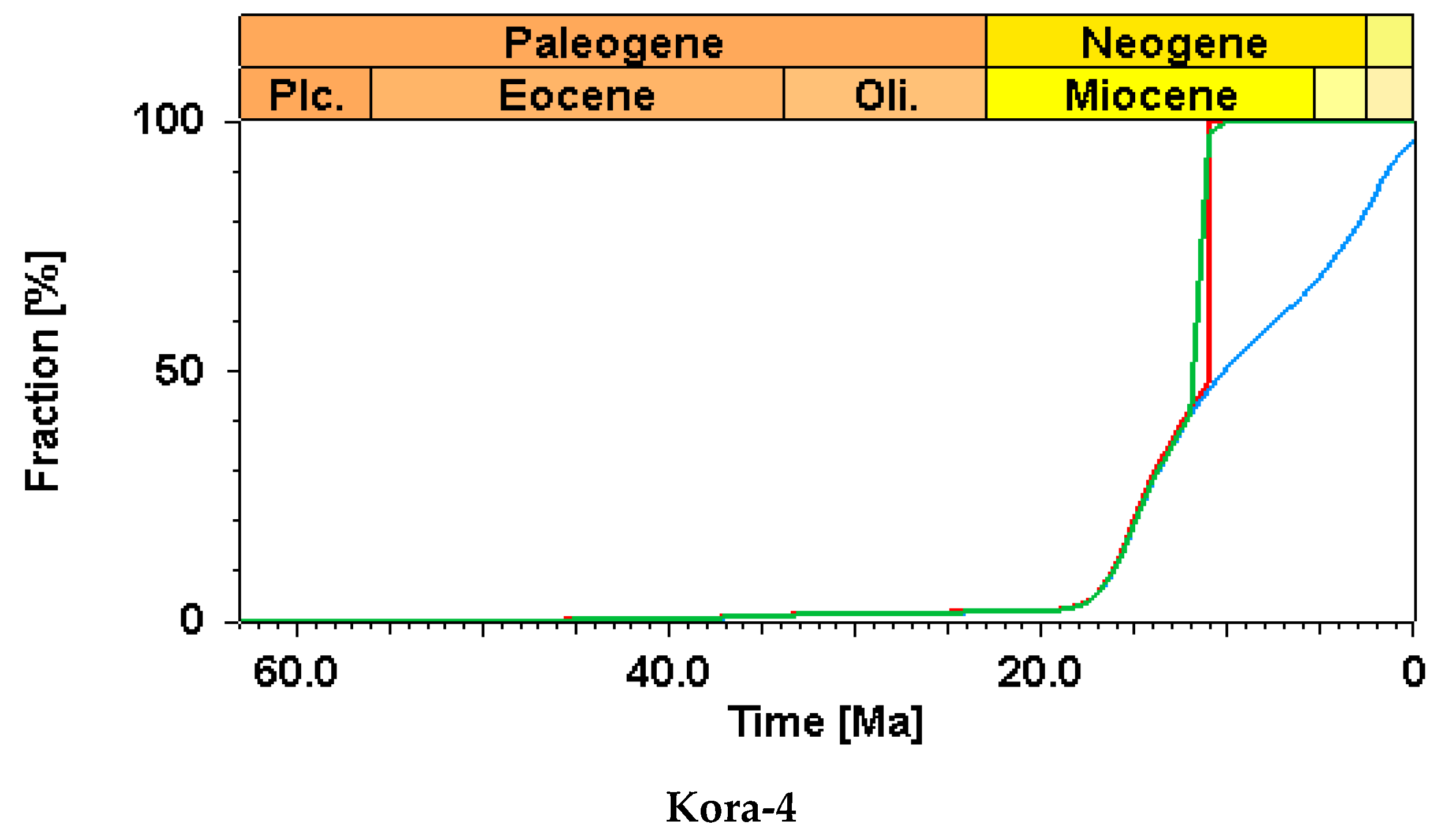
3.2. 1D and 3D Modeling
3.3. Thermal Calibration and Heat Flow
3.4. Intrusion Modeling
4. Model Setup
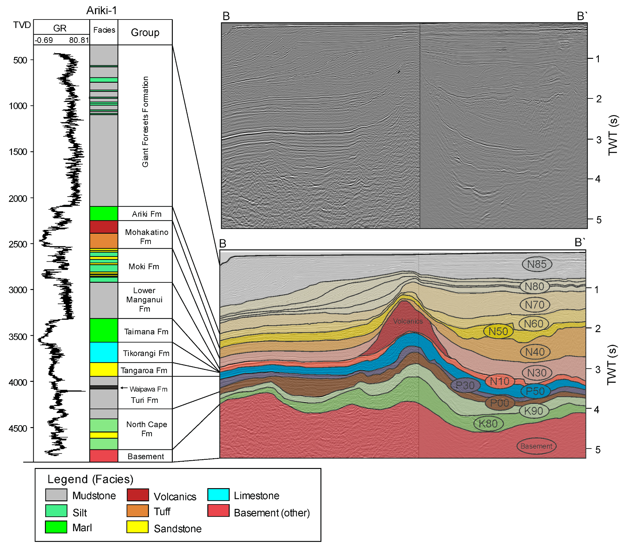
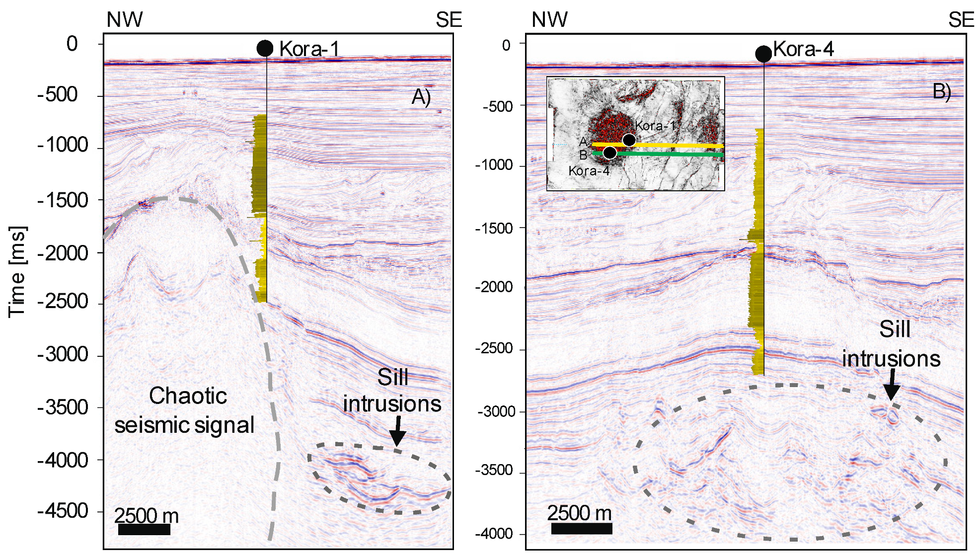
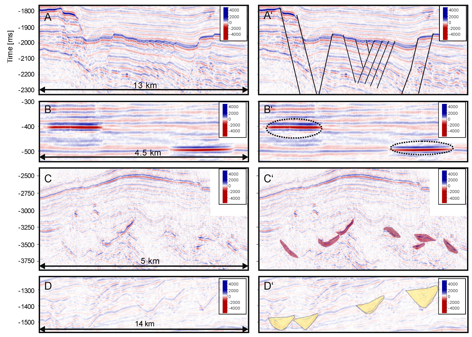
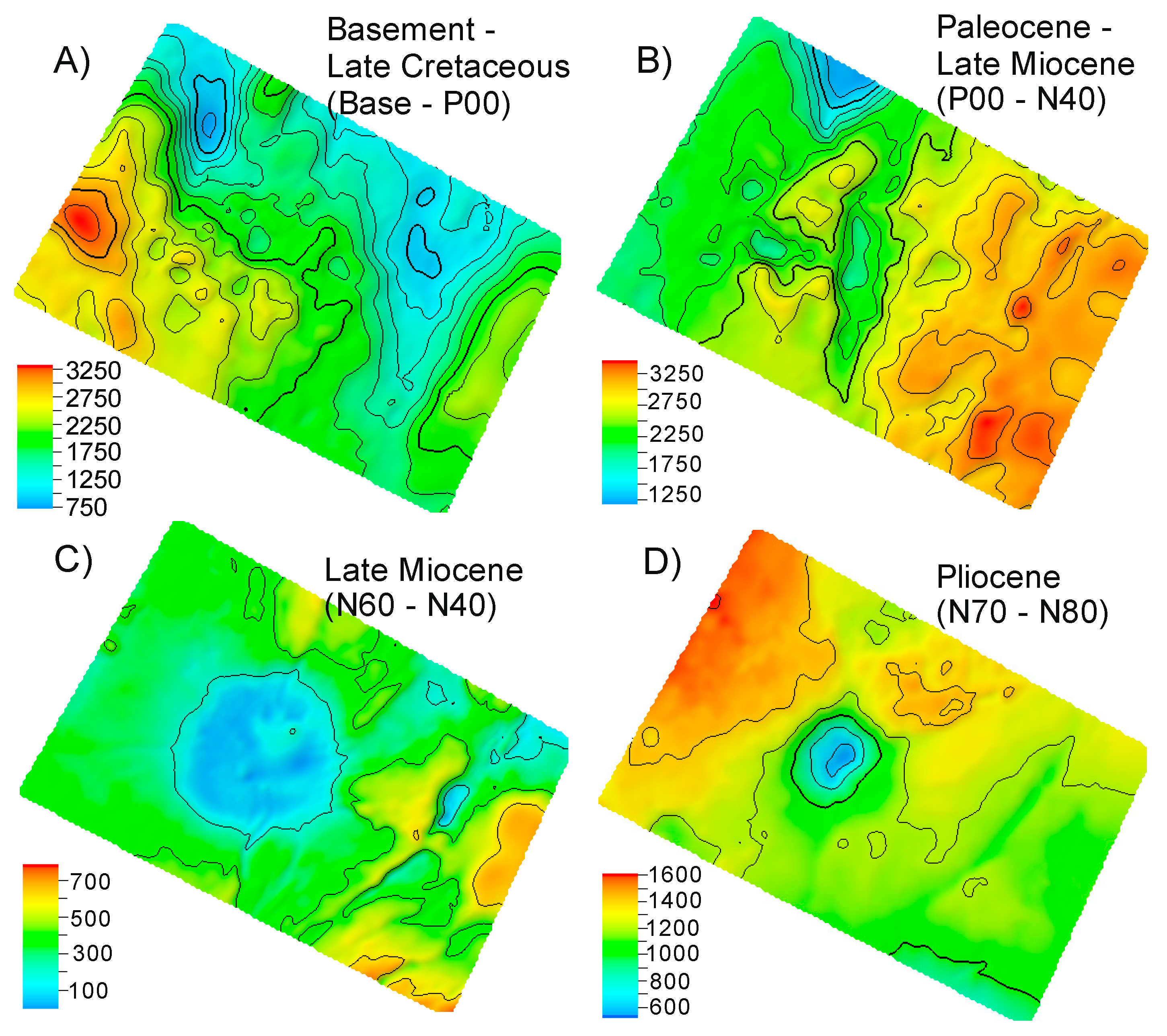
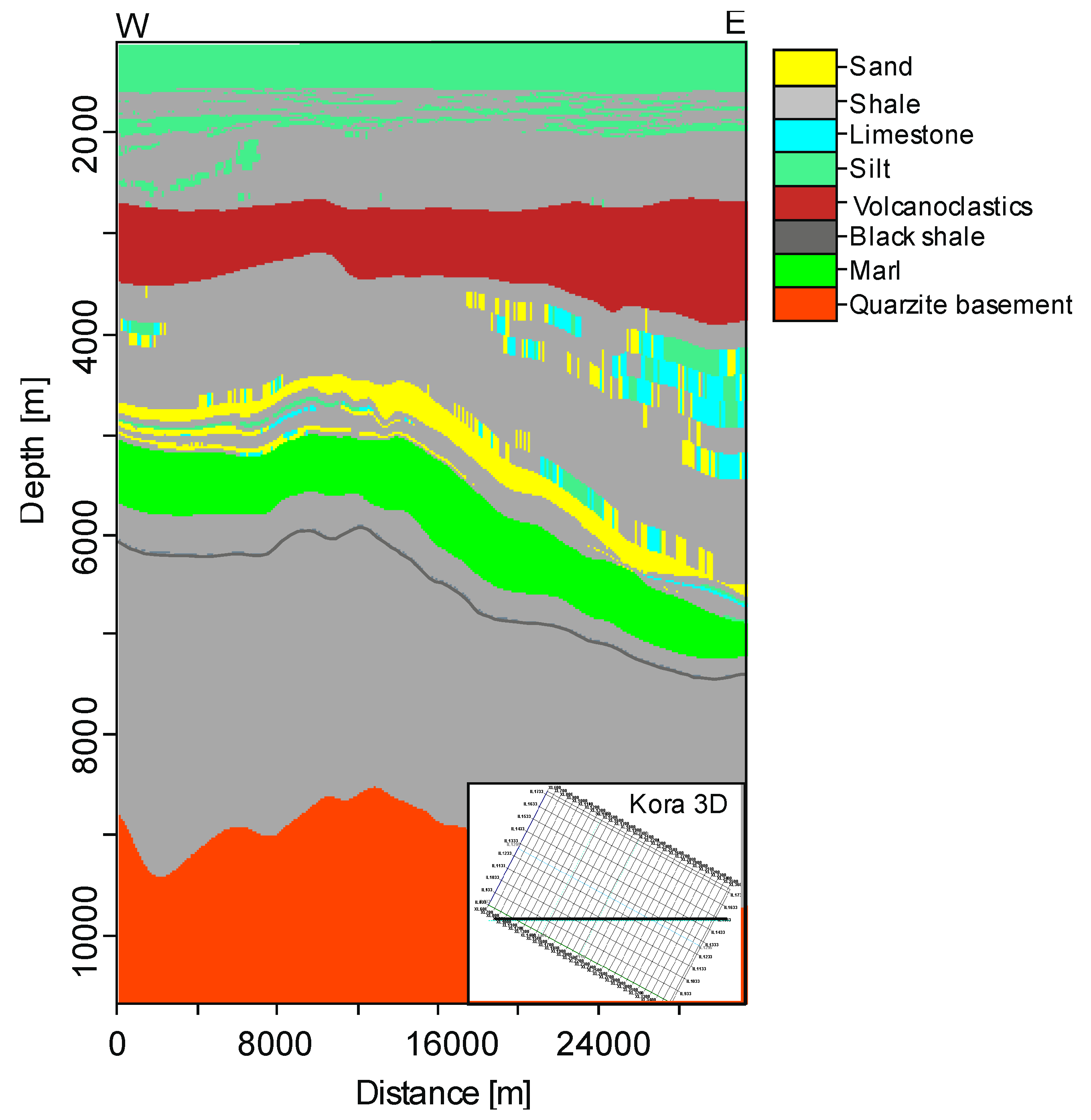
4.1. Seismic Interpretation in Kora 3D
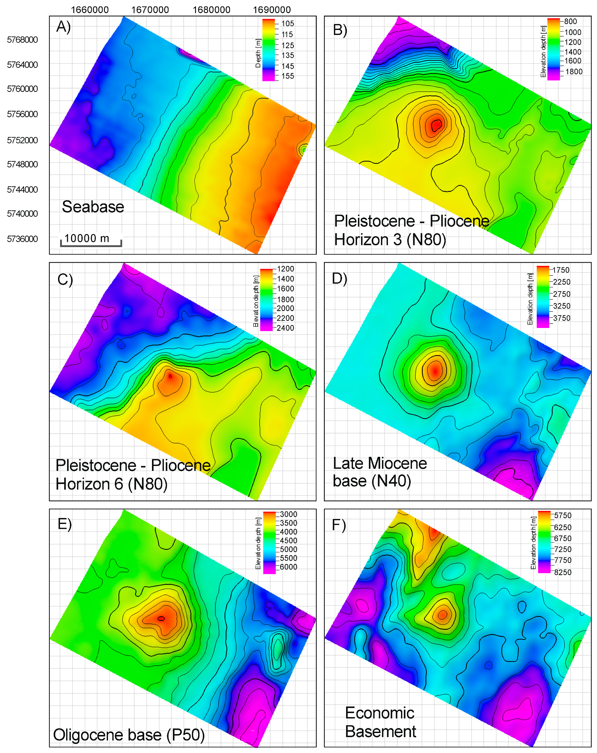
4.2. Seismic Horizons
4.3. Thickness Variations
5. Results and Discussion
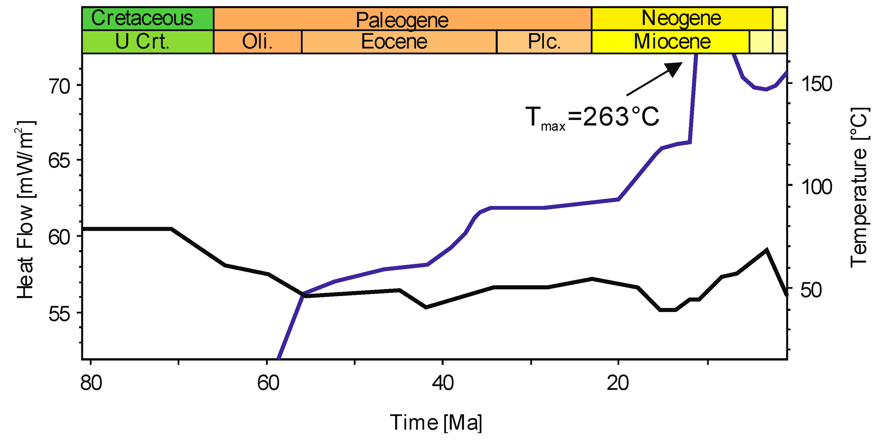
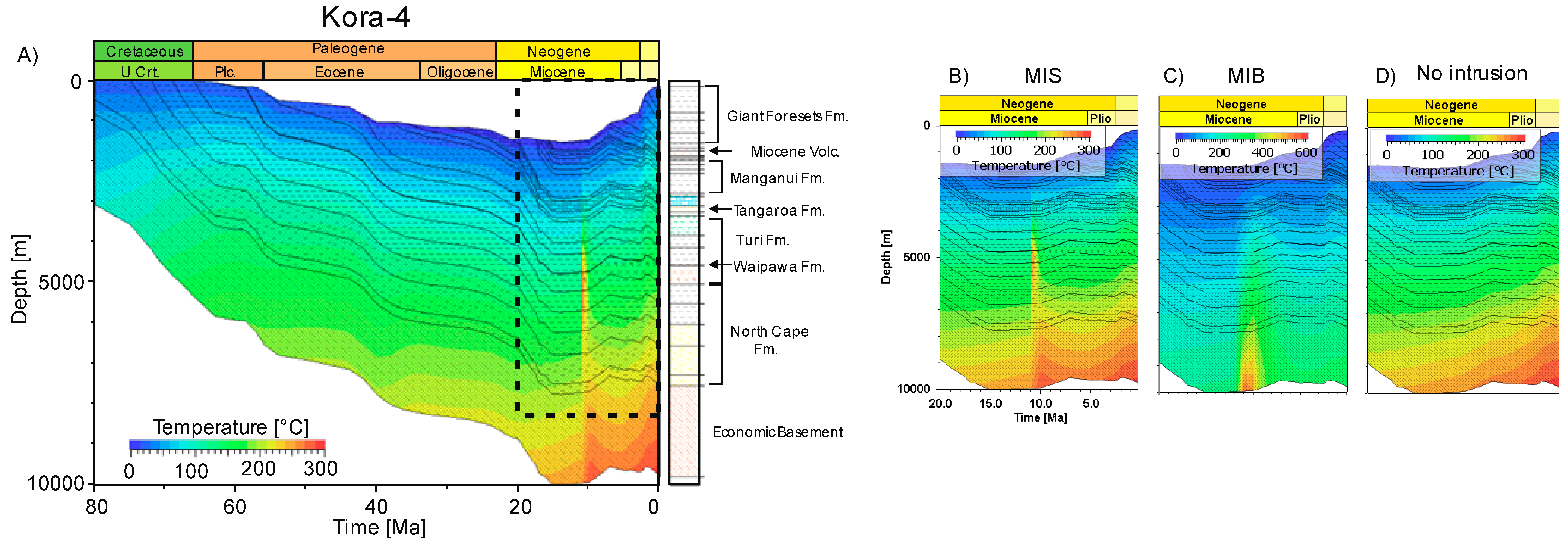
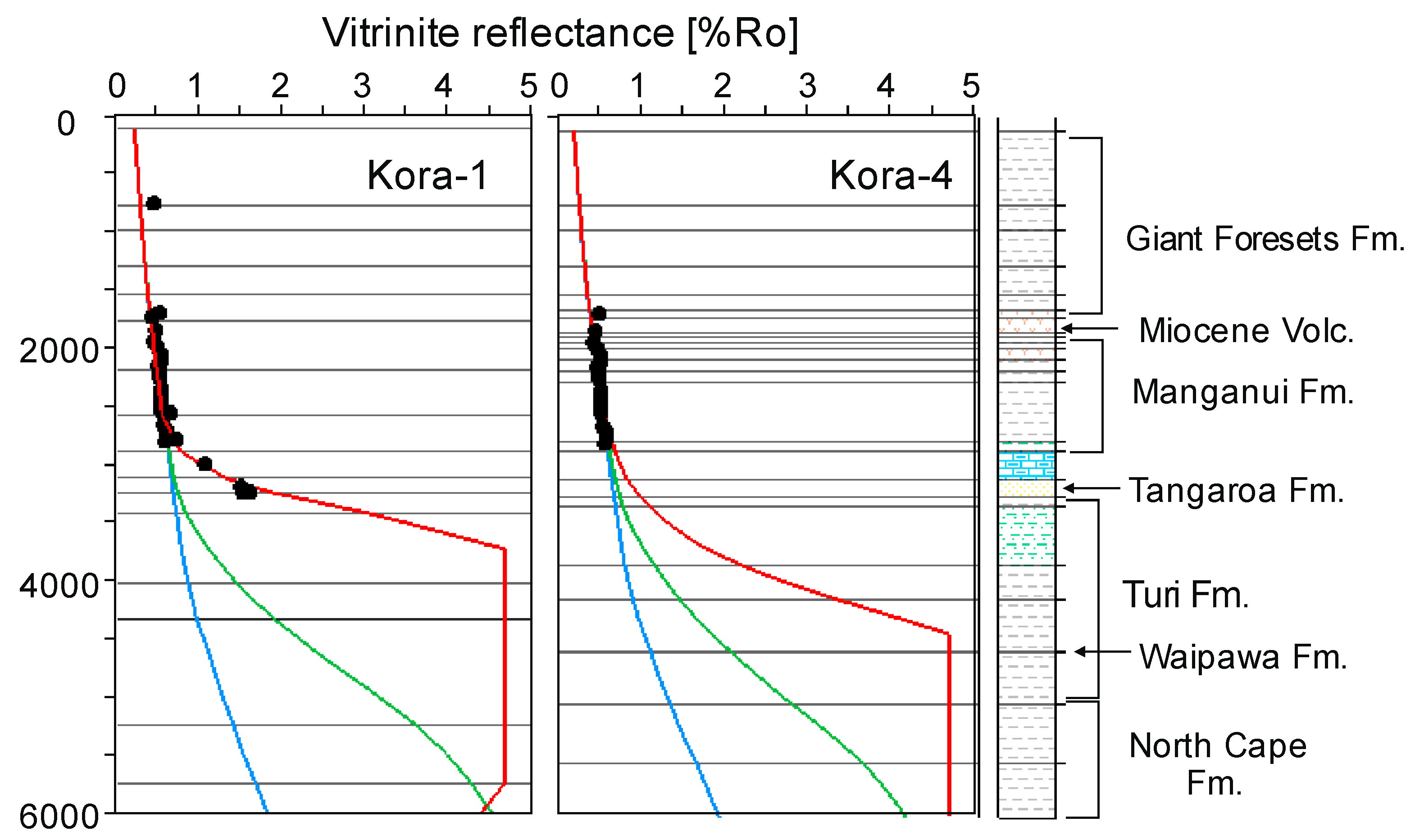
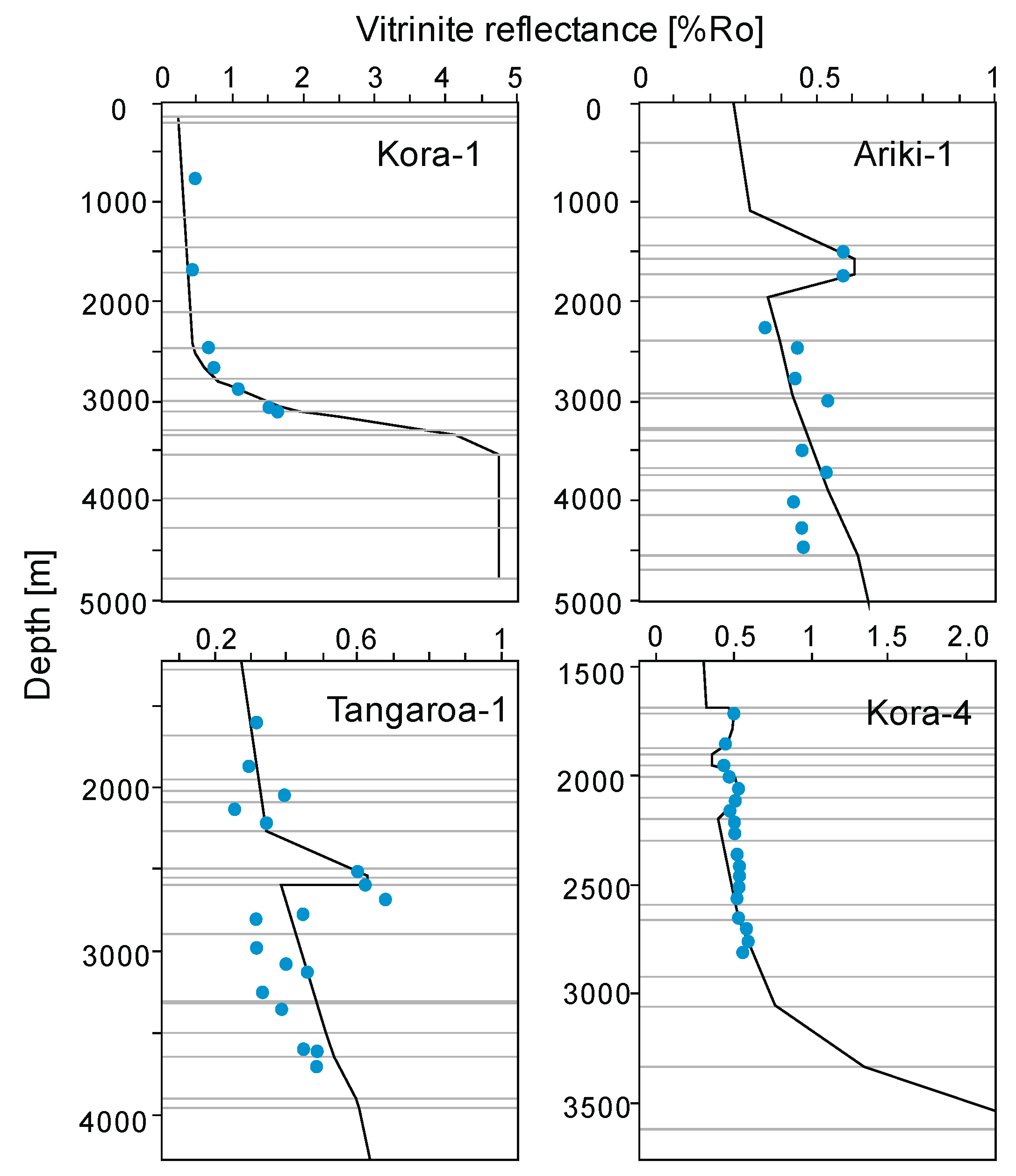
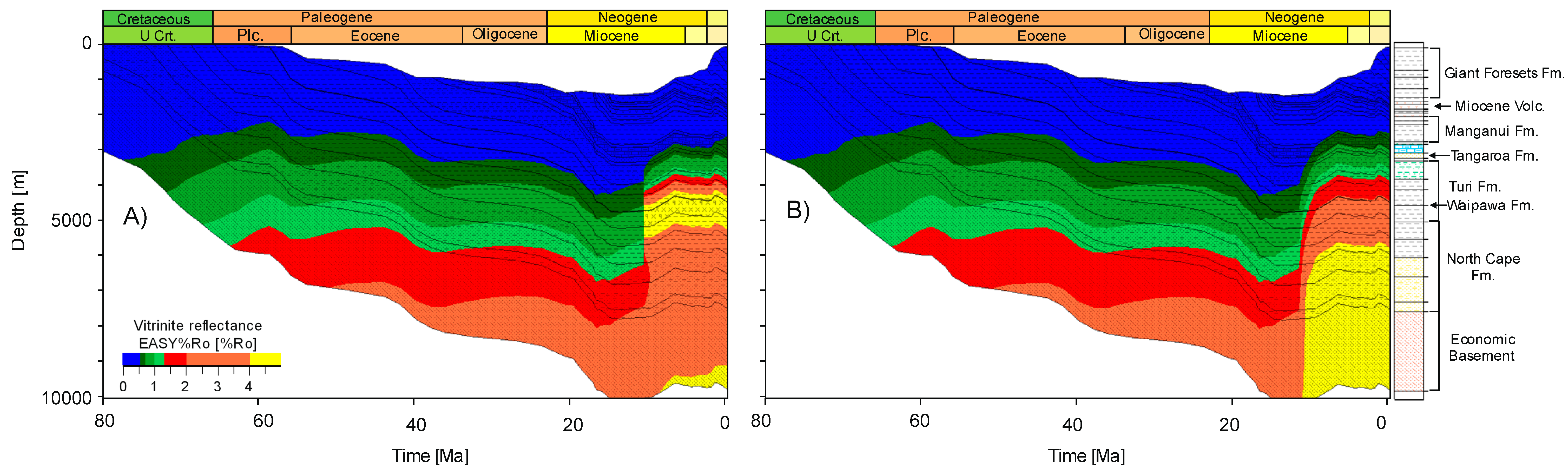
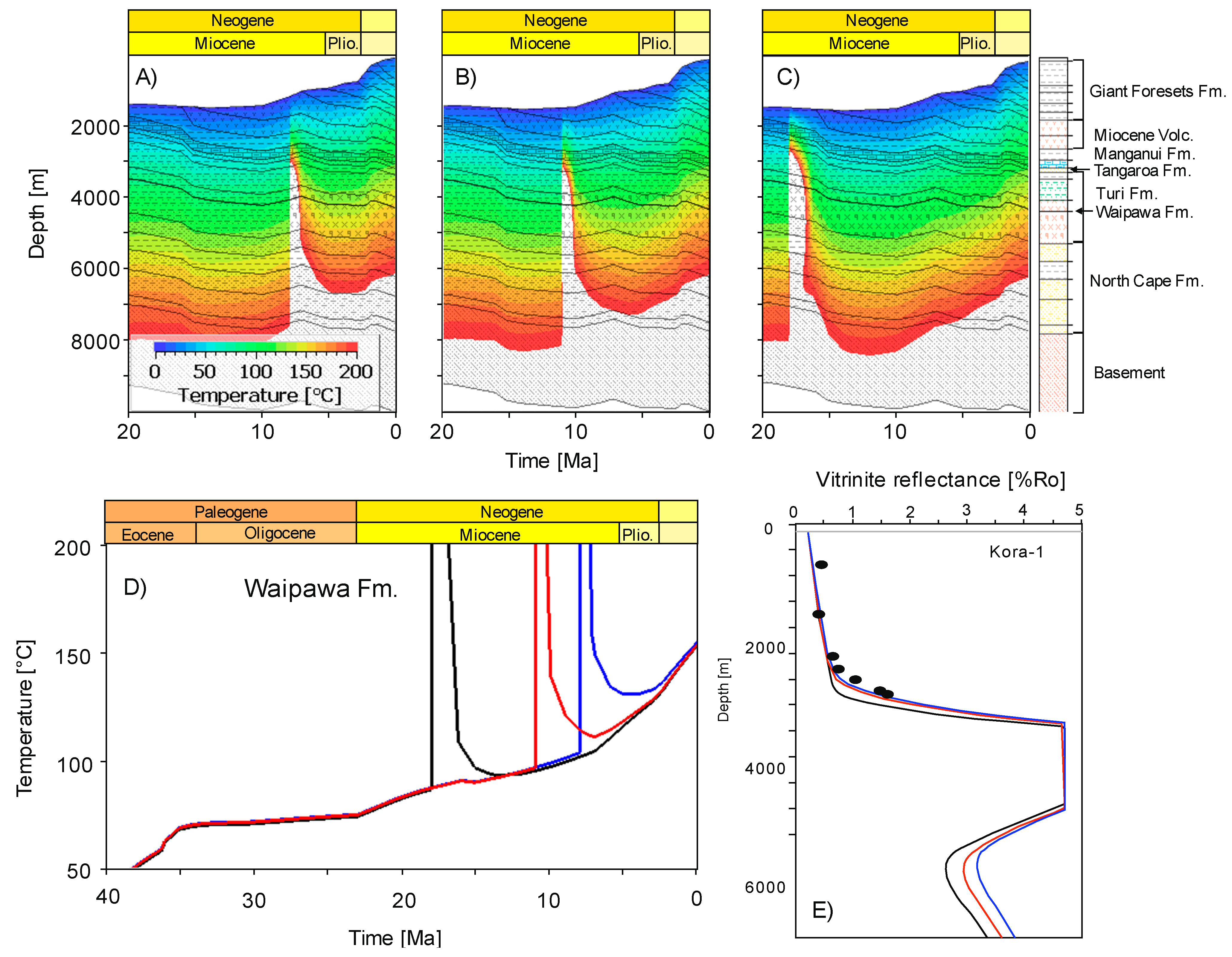
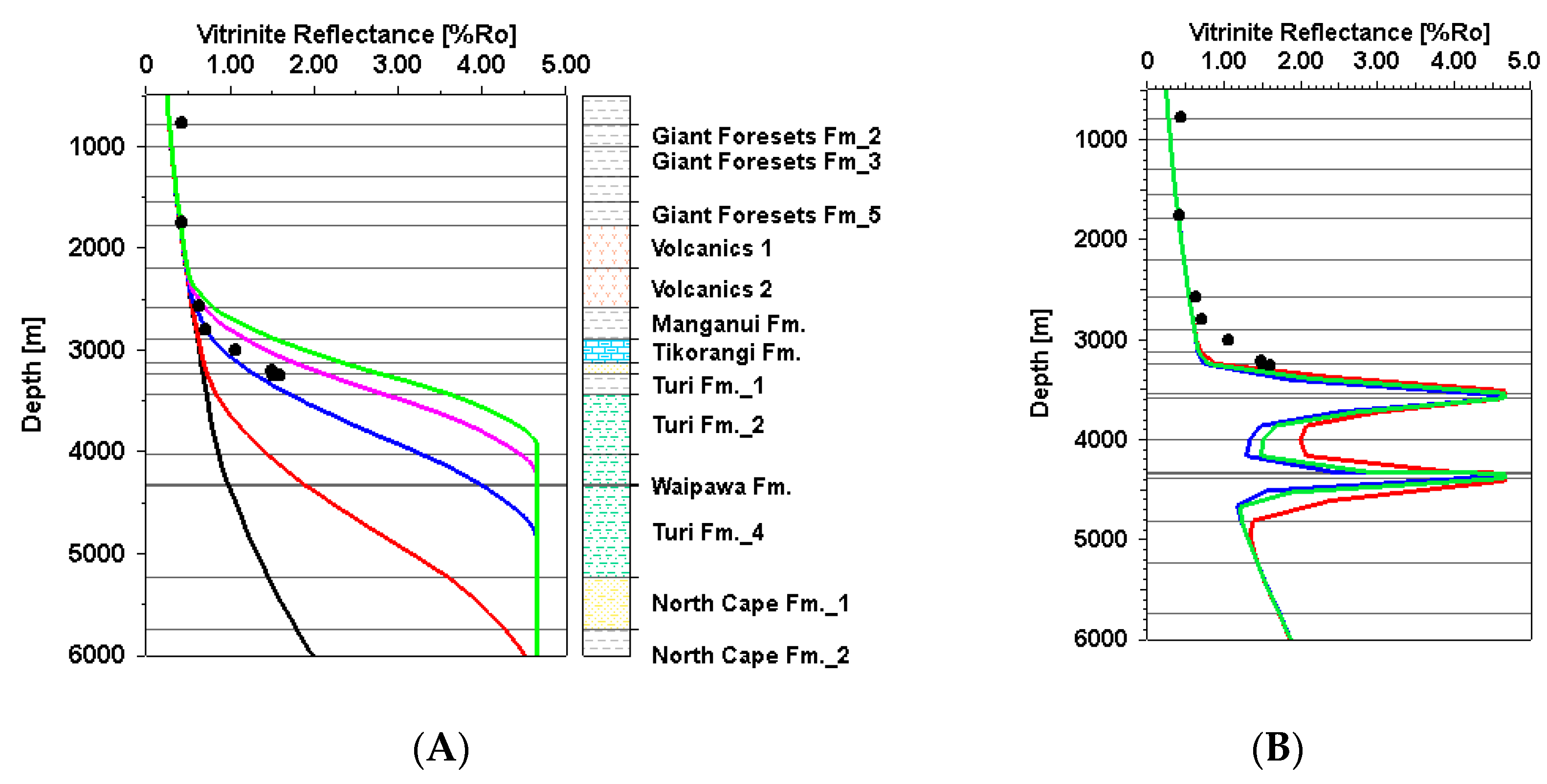
5.1. 1D Modeling Results
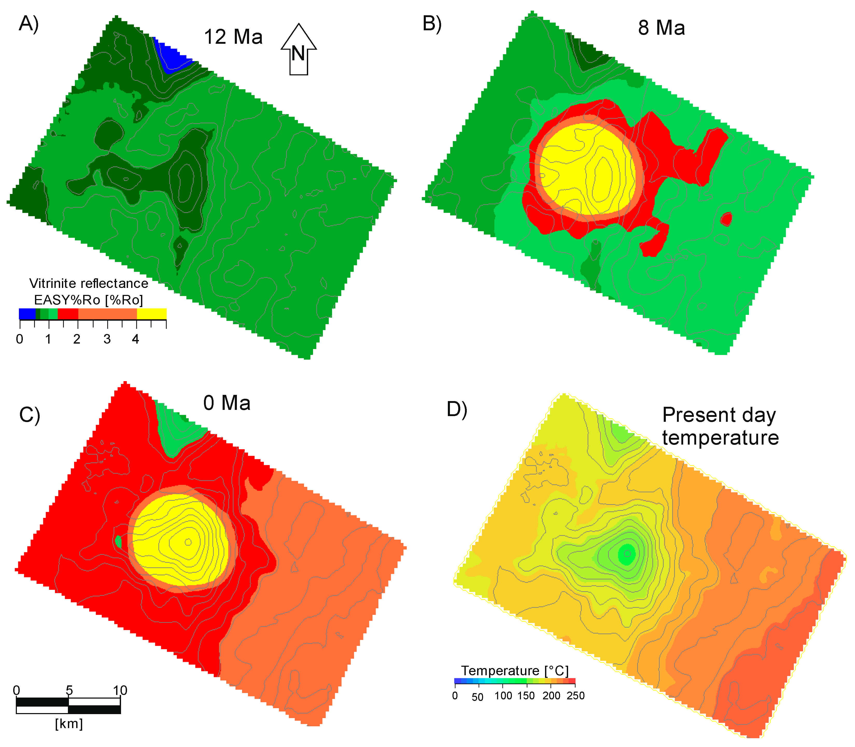
5.2. 3D Modeling Results
5.3. Sensitivity Analysis
6. Conclusions
Author Contributions
Funding
Acknowledgments
Conflicts of Interest
References
- Hantschel, T.; Kauerauf, A.I. Fundamentals of Basin and Petroleum Systems Modeling; Springer: Dordrecht, The Netherlands; New York, NY, USA, 2009; 476p, ISBN 978-3-540-72317-2. [Google Scholar]
- Senger, K.; Millet, J.; Planke, S.; Ogata, K.; Eide, C.H.; Festøy, M.; Galland, O.; Jerram, D.A. Effects of igneous intrusions on the petroleum system: A review. First Break 2017, 35, 47–56. [Google Scholar]
- Feng, Z. Volcanic rocks as prolific gas reservoir: A case study from the Qingshen gas field in the Songliao Basin, NE China. Mar. Pet. Geol. 2008, 25, 416–432. [Google Scholar] [CrossRef]
- Liu, J.; Wang, P.; Zhang, Y.; Bian, W.; Huang, Y.; Tang, H.; Che, X. Volcanic Rock-Hosted Natural Hydrocarbon Resources: A Review. In Updates in Volcanology—New Advances in Understanding Volcanic Systems; Nemeth, K., Ed.; InTech: London, UK, 2012; pp. 151–179. ISBN 978-953-51-0915-0. [Google Scholar]
- Mørk, A.; Bjorøy, M. Mesozoic Source Rocks on Svalbard. In Petroleum Geology of the North European Margin; Spencer, A.M., Ed.; Springer: Dordrecht, The Netherlands, 1984; pp. 371–382. ISBN 978-94-010-8982-1. [Google Scholar]
- Rohrman, M. Prospectivity of volcanic basins: Trap delineation and acreage de-risking. AAPG Bull. 2007, 91, 915–939. [Google Scholar] [CrossRef]
- Aarnes, I.; Svensen, H.; Connolly, J.A.D.; Podladchikov, Y.Y. How contact metamorphism can trigger global climate changes: Modeling gas generation around igneous sills in sedimentary basins. Geochim. Cosmochim. Acta 2010, 74, 7179–7195. [Google Scholar] [CrossRef]
- Galushkin, Y.I. Thermal effects of igneous intrusions on maturity of organic matter: A possible mechanism of intrusion. Org. Geochem. 1997, 26, 645–658. [Google Scholar] [CrossRef]
- Lampe, C.; Kornpihl, K.; Sciamanna, S.; Zapata, T.; Zamora, G.; Varadé, R. Petroleum systems modeling in tectonically complex areas—A 2D migration study from the Neuquen Basin, Argentina. J. Geochem. Explor. 2006, 89, 201–204. [Google Scholar] [CrossRef]
- Lee, G.H.; Kwon, Y.I.; Yoon, C.S.; Kim, H.J.; Yoo, H.S. Igneous complexes in the eastern Northern South Yellow Sea Basin and their implications for hydrocarbon systems. Mar. Pet. Geol. 2006, 23, 631–645. [Google Scholar] [CrossRef]
- Jones, S.F.; Wielens, H.; Williamson, M.C.; Zentilli, M. Impact of magmatism on petroleum systems in the Sverdrup Basin, Canadian Arctic Islands, Nunavut: A numerical modeling study. J. Pet. Geol. 2007, 30, 237–256. [Google Scholar] [CrossRef]
- Bischoff, A.P.; Nicol, A.; Beggs, M. Stratigraphy of architectural elements in a buried volcanic system and implications for hydrocarbon exploration. Interpretation 2017, 5, 141–159. [Google Scholar] [CrossRef]
- Infante-Paez, L.; Marfurt, K.J. Seismic expression and geomorphology of igneous bodies: A Taranaki Basin, New Zealand, case study. Interpretation 2017, 5, 121–140. [Google Scholar] [CrossRef]
- Morley, C.K. 3-D seismic imaging of the plumbing system of the Kora Volcano, Taranaki Basin, New Zealand: The influence of syn-rift structure on shallow igneous intrusion architecture. Geosphere 2018, 14, 2533–2584. [Google Scholar] [CrossRef]
- Stagpoole, V.; Funnell, R. Arc magmatism and hydrocarbon generation in the northern Taranaki Basin, New Zealand. Pet. Geosci. 2001, 7, 255–267. [Google Scholar] [CrossRef]
- Aarnes, I.; Svensen, H.; Polteau, S.; Planke, S. Contact metamorphic devolatilization of shales in the Karoo Basin, South Africa, and the effects of multiple sill intrusions. Chem. Geol. 2011, 281, 181–194. [Google Scholar] [CrossRef]
- Fjeldskaar, W.; Helset, H.M.; Johansen, H.; Grunnaleite, I.; Horstad, I. Thermal modeling of magmatic intrusions in the Gjallar Ridge, Norwegian Sea: Implications for vitrinite reflectance and hydrocarbon maturation. Basin Res. 2008, 20, 143–159. [Google Scholar] [CrossRef]
- Sydnes, M.; Fjeldskaar, W.; Løtveit, I.F.; Grunnaleite, I.; Cardozo, N. The importance of sill thickness and timing of sill emplacement on hydrocarbon maturation. Mar. Pet. Geol. 2018, 89, 500–514. [Google Scholar] [CrossRef]
- Escalona, A.; Fjeldskaar, W.; Grunnaleite, I. Basin modeling across the emergent Lesser Antilles island arc, SE Caribbean and impact on petroleum systems. First Break 2011, 29, 41–51. [Google Scholar] [CrossRef]
- King, P.R.; Thrasher, G.P. Cretaceous-Cenozoic Geology and Petroleum Systems of the Taranaki Basin: Institute of Geological and Nuclear Sciences Limited, Monograph 13; GNS Science: Lower Hutt, New Zealand, 1996; ISBN 978-0-478-19754-9. [Google Scholar]
- Giba, M.; Nicol, A.; Walsh, J.J. Evolution of faulting and volcanism in a back-arc basin and its implications for subduction processes: Taranaki Basin Evolution. Tectonics 2010, 29, 1–8. [Google Scholar] [CrossRef]
- Giba, M.; Walsh, J.J.; Nicol, A.; Mouslopoulou, V.; Seebeck, H. Investigation of the spatio-temporal relationship between normal faulting and arc volcanism on million-year time scales. J. Geol. Soc. 2013, 170, 951–962. [Google Scholar] [CrossRef]
- Strogen, D.P.; Seebeck, H.; Nicol, A.; King, P.R. Two-phase Cretaceous–Paleocene rifting in the Taranaki Basin region, New Zealand; implications for Gondwana break-up. J. Geol. Soc. 2017, 174, 929–946. [Google Scholar] [CrossRef]
- Reilly, C.; Nicol, A.; Walsh, J.J.; Seebeck, H. Evolution of faulting and plate boundary deformation in the Southern Taranaki Basin, New Zealand. Tectonophysics 2015, 651–652, 1–18. [Google Scholar] [CrossRef]
- King, P.R.; Thrasher, G.P. Post-Eocene Development of the Taranaki Basin, New Zealand: Convergent Overprint of a Passive Margin. In Geology and Geophysics of Continental Margins; Watkins, J.S., Zhiqiang, F., McMillen, K.J., Eds.; American Association of Petroleum Geologists: Tulsa, OK, USA, 1992; Volume 53, pp. 93–118. ISBN 978-1-62981-107-9. [Google Scholar]
- Stagpoole, V.; Nicol, A. Regional structure and kinematic history of a large subduction back thrust: Taranaki Fault, New Zealand. J. Geophys. Res. 2008, 113, 1–19. [Google Scholar] [CrossRef]
- Holt, W.E.; Stern, T.A. Subduction, platform subsidence, and foreland thrust loading: The late Tertiary development of Taranaki Basin, New Zealand. Tectonics 1994, 13, 1068–1092. [Google Scholar] [CrossRef]
- Bergamn, S.C.; Talbot, J.P.; Thompson, P.R. The Kora Miocene submarine Andesite stratovolcano hydrocarbon reservoir, Northern Taranaki Basin, New Zealand. In Proceedings of the New Zealand Oil Exploration Conference, Wellington, New Zealand, 15–18 September 1991; pp. 178–206. [Google Scholar]
- Seebeck, H.; Nicol, A.; Villamor, P.; Ristau, J.; Pettinga, J. Structure and kinematics of the Taupo Rift, New Zealand: Taupo Rift. Tectonics 2014, 33, 1178–1199. [Google Scholar] [CrossRef]
- Bull, S.; Nicol, A.; Strogen, D.; Kroeger, K.F.; Seebeck, H.S. Tectonic controls on Miocene sedimentation in the Southern Taranaki Basin and implications for New Zealand plate boundary deformation. Basin Res. 2019, 31, 253–273. [Google Scholar] [CrossRef]
- Reed, J.D. Exploration geochemistry of the Taranaki Basin with emphasis on Kora. In Proceedings of the Oil Exploration Conference, Wellington, New Zealand, 15–18 September 1991; Ministry of Commerce: Wellington, New Zealand, 1992; pp. 364–372. [Google Scholar]
- Gresko, M.D.; Jordan, D.W.; Thompson, P.R. A Sequence Stratigraphic Study of the Tangaroa Sandstone, Taranaki Basin, New Zealand. AAPG Bull. 1990, 74. [Google Scholar] [CrossRef]
- Arco Petroleum NZ Inc. Kora-4 Final Well Report; Petroleum Report Series PR 1443; Ministry of Economic Development New Zealand: Wellington, New Zealand, 1985; Unpublished Petroleum Report. [Google Scholar]
- Arco Petroleum NZ Inc. Kora-1 Kora-1A. Final Well Report; Petroleum Report Series PR 1374; Ministry of Economic Development New Zealand: Wellington, New Zealand, 1988; Unpublished Petroleum Report. [Google Scholar]
- Arco Petroleum NZ Inc. Kora-2 Final Well Report; Petroleum Report Series PR 1441; Ministry of Economic Development New Zealand: Wellington, New Zealand, 1988; Unpublished Petroleum Report. [Google Scholar]
- Arco Petroleum NZ Inc. Kora-3 Final Well Report; Petroleum Report Series PR 1441; Ministry of Economic Development New Zealand: Wellington, New Zealand, 1988; Unpublished Petroleum Report. [Google Scholar]
- Killops, S.D.; Woolhouse, A.D. A Geochemical Appraisal of Oil Generation in the Taranaki Basin, New Zealand. AAPG Bull. 1994, 78, 1560–1585. [Google Scholar]
- Murray, A.P.; Summons, R.E.; Boreham, C.J.; Dowling, L.M. Biomarker and n-alkane isotope profiles for Tertiary oils: relationship to source rock depositional setting. Org. Geochem. 1994, 22, 521–542. [Google Scholar] [CrossRef]
- Naeher, S.; Hollis, C.J.; Clowes, C.D.; Ventura, G.T.; Shepherd, C.L.; Crouch, E.M.; Morgans, H.E.G.; Bland, K.J.; Strogen, D.P.; Sykes, R. Depositional and organofacies influences on the petroleum potential of an unusual marine source rock: Waipawa Formation (Paleocene) in southern East Coast Basin, New Zealand. Mar. Pet. Geol. 2019, 104, 468–488. [Google Scholar] [CrossRef]
- Hollis, C.J.; Tayler, M.J.S.; Andrew, B.; Taylor, K.W.; Lurcock, P.; Bijl, P.K.; Kulhanek, D.K.; Crouch, E.M.; Nelson, C.S.; Pancost, R.D.; et al. Organic-rich sedimentation in the South Pacific Ocean associated with Late Paleocene climatic cooling. Earth Sci. Rev. 2014, 134, 81–97. [Google Scholar] [CrossRef]
- Johasen, P.E. Phase Kinetics for Two Source Rock Samples from Outcrop Black’s Quarry and Well Ariki-1, Kjeller, Norway, 2005; 27, Unpublished Petroleum Report.
- Schiøler, P.; Rogers, K.; Sykes, R.; Hollis, C.J.; Ilg, B.; Meadows, D.; Roncaglia, L.; Uruski, C. Palynofacies, organic geochemistry and depositional environment of the Tartan Formation (Late Paleocene), a potential source rock in the Great South Basin, New Zealand. Mar. Pet. Geol. 2010, 27, 351–369. [Google Scholar] [CrossRef]
- Sell BP Todd Oil Service Ltd. Completion Report Ariki-1 Well; PPL 38048; Ministry of Economic Development New Zealand: Wellington, New Zealand, 1984. [Google Scholar]
- Funnell, R.; Chapman, D.; Allis, R.; Armstrong, P. Thermal state of the Taranaki Basin, New Zealand. J. Geophys. Res. Solid Earth 1996, 101, 25197–25215. [Google Scholar] [CrossRef]
- OMV New Zealand Ltd. Final Seismic Interpretation Report for PEP 38485 (Kora); Ministry of Economic Development New Zealand: Wellington, New Zealand, 2011; Unpublished Petroleum Report. [Google Scholar]
- Kroeger, K.F.; Funnell, R.H.; Nicol, A.; Fohrmann, M.; Bland, K.J.; King, P.R. 3D crustal-scale heat-flow regimes at a developing active margin (Taranaki Basin, New Zealand). Tectonophysics 2013, 591, 175–193. [Google Scholar] [CrossRef]
- Kroeger, K.F.; Funnell, R.H. Warm Eocene climate enhanced petroleum generation from Cretaceous source rocks: A potential climate feedback mechanism? Petroleum generation climate feedback. Geophys. Res. Lett. 2012, 39, 1–6. [Google Scholar] [CrossRef]
- Strogen, D.P. Updated Paleogeographic Maps for the Taranaki Basin and Surrounds; GNS Science: Lower Hutt, New Zealand, 2011; p. 83. [Google Scholar]
- Wygrala, B.P. Integrated Study of an Oil Field in the Southern Po Basin, Northern Italy; University of Cologne: Cologne, Germany, 1989. [Google Scholar]
- Bull, S.; Hill, M.; Strogen, D.P.; Arnot, M.J.; Seebeck, H.; Kroeger, K.F.; Zhu, H. Seismic Reflection Interpretation, Static Modeling and Velocity Modeling of the Southern Taranaki Basin (4D Taranaki Project); GNS Science: Lower Hutt, New Zealand, 2016. [Google Scholar]
- Koide, H.; Bhattacharji, S. Formation of fractures around magmatic intrusions and their role in ore localization. Econ. Geol. 1975, 70, 781–799. [Google Scholar] [CrossRef]
- Strogen, D.; King, P.R. A New Zealandia-Wide Seismic Horizon Naming Scheme; GNS Science: Lower Hutt, New Zealand, 2014; p. 20. [Google Scholar]
- Lewis, S.D.; Behrmann, J.H.; Musgrave, R.J.; Cande, S.C. (Eds.) Proceedings of the Ocean Drilling Program, Scientific Results; D.W. Friesen & Sons Ltd.: Altona, MB, Canada, 1995; Volume 141, pp. 279–286. [Google Scholar]
- Littke, R.; Disko, U.; Rullkotter, J. Characterization of Organic Matter in Deep-Sea Sediments on the Chile Continental Margin with Special Emphasis on Maturation in an Area of High Geothermal Heat Flow. In Proceedings of the Ocean Drilling Program, Scientific Results; Lewis, S.D., Behrmann, J.H., Musgrave, R.J., Cande, S.C., Eds.; D.W. Friesen & Sons Ltd.: Altona, MB, Canada, 1995; Volume 141, pp. 119–132. [Google Scholar]
- Baumgartner, R.; Fontbote, L.; Spikings, R.; Ovtcharova, M.; Schaltegger, U.; Schneider, J.; Page, L.; Gutjahr, M. Bracketing the Age of Magmatic-Hydrothermal Activity at the Cerro de Pasco Epithermal Polymetallic Deposit, Central Peru: A U-Pb and 40Ar/39Ar Study. Econ. Geol. 2009, 104, 479–504. [Google Scholar] [CrossRef]
- Tanaka, A.; Yamano, M.; Yano, Y.; Sasada, M. Geothermal gradient and heat flow data in and around Japan (I): Appraisal of heat flow from geothermal gradient data. Earth Planets Space 2004, 56, 1191–1194. [Google Scholar] [CrossRef]
- Monreal, F.R.; Villar, H.J.; Baudino, R.; Delpino, D.; Zencich, S. Modeling an atypical petroleum system: A case study of hydrocarbon generation, migration and accumulation related to igneous intrusions in the Neuquen Basin, Argentina. Mar. Pet. Geol. 2009, 26, 590–605. [Google Scholar] [CrossRef]


| Stratigraphic Unit | V Min/Max (m/s) |
|---|---|
| Seabed | 1500 |
| N80 | 1786 |
| Prograd 1 | 2250 |
| Prograd 2 | 2300 |
| Prograd 3 | 2592 |
| Prograd 4 | 2600 |
| Prograd 5 | 2700 |
| N70 | 2900 |
| N60 | 3050 |
| N40 | 3500 |
| Volcanic base | 4800 |
| P50 | 3100 |
| P30 | 3300 |
| P10 | 3600 |
| P00 | 3800 |
| K90 | 4100 |
| K80 | 4200 |
| Economic basement | 4800 |
| Formation Name | Age [Ma] | Depth [m] | Thickness [m] | Dominant Lithology | Thermal Conductivity | |
|---|---|---|---|---|---|---|
| [W/(mK)] at 20 °C | [W/(mK)] at 100 °C | |||||
| Giant Foresets | 0 | 150 | 297 | Shale 60%; Siltst 35%; Limest(shaly)5% | 2.1 | 2.03 |
| 1.6 | 447 | 503 | Shale 60%; Siltst 35%; Limest(shaly) 5% | 2.1 | 2.03 | |
| 2.5 | 950 | 385 | Shale 50%; Siltst (org lean) 50% | 3 | 2.7 | |
| 3 | 1335 | 815 | Shale 70%; Siltst (org lean) 30% | 3.2 | 2.84 | |
| Ariki | 5 | 2150 | 106 | Marl 40%; Shale50%; Silt (org. lean) 10% | 2.9 | 2.62 |
| Mohakatino / Upper Manganui | 8 | 2256 | 134 | Shale 30%; Tuff 50%; Σ(Pyrite, Chlorite, Quartz, Olivine)=20% | 2.6 | 2.4 |
| Mohakatino | 10 | 2390 | 175 | Sandst 10%; Tuff 70%; Σ(Pyrite, Chlorite, Quartz, Olivine)=20% | 2.6 | 2.4 |
| Moki Equivalent | 13 | 2565 | 351 | Silt 70%; Sandst30 % | 2.8 | 2.54 |
| Lower Manganui | 17 | 2916 | 431 | Shale (organic rich) | 2.8 | 2.54 |
| Taimana Fm. | 22 | 3347 | 38 | Marl | 2.7 | 2.47 |
| Tikorangi | 23 | 3385 | 226 | Lst 50%; Marl 50% | 2.7 | 2.47 |
| Tangaroa | 31 | 3611 | 11 | Sandst (arkose) | 2.4 | 2.47 |
| 31.5 | 3622 | 8 | Sandst 70%; Lst 30% | 2.4 | 2.25 | |
| 32 | 3630 | 94 | Sandst (arkose) | 2.4 | 2.25 | |
| Turi upper | 36 | 3724 | 214 | Shale 60%; Marl 30%; Sandst 10% | 2.3 | 2.18 |
| 42 | 3938 | 58 | Shale 70%; Lst 30% | 2.7 | 2.47 | |
| 56 | 3996 | 111 | Silt (organic lean) | 2.6 | 2.4 | |
| Waipawa | 58.7 | 4107 | 12 | Shale (black) | 0.9 | 1.15 |
| Turi lower | 61.2 | 4119 | 200 | Silt (organic lean) | 2.6 | 2.4 |
| North Cape | 66 | 4319 | 319 | Silt 50%; Sandst 50% | 3.1 | 2.76 |
| 80 | 4638 | 124 | Shale (sandy) | 3.2 | 2.84 | |
| Base | 110 | 4762 | 2238 | Quartzite | 3.6 | 3.13 |
| Age | Source Rock Unit | TOC (wt.%) | HI (mgHC/g TOC) | Depositional Environment | Type |
|---|---|---|---|---|---|
| Paleocene | Waipawa Black Shale | 9.8 | 445 | Deep marine | II/III |
| Lithology | Age [Ma] | Intrusion Temperature [t°C] | Magma Dencity [kg/m3] | Magma Heat Capacity [kcal/kg/K] | Crystallization Heat [MJ/m3] |
|---|---|---|---|---|---|
| Andesite (igneous) | 11 | 950 | 2750 | 0.7 | 700 |
© 2019 by the authors. Licensee MDPI, Basel, Switzerland. This article is an open access article distributed under the terms and conditions of the Creative Commons Attribution (CC BY) license (http://creativecommons.org/licenses/by/4.0/).
Share and Cite
Kutovaya, A.; Kroeger, K.F.; Seebeck, H.; Back, S.; Littke, R. Thermal Effects of Magmatism on Surrounding Sediments and Petroleum Systems in the Northern Offshore Taranaki Basin, New Zealand. Geosciences 2019, 9, 288. https://doi.org/10.3390/geosciences9070288
Kutovaya A, Kroeger KF, Seebeck H, Back S, Littke R. Thermal Effects of Magmatism on Surrounding Sediments and Petroleum Systems in the Northern Offshore Taranaki Basin, New Zealand. Geosciences. 2019; 9(7):288. https://doi.org/10.3390/geosciences9070288
Chicago/Turabian StyleKutovaya, Anna, Karsten F. Kroeger, Hannu Seebeck, Stefan Back, and Ralf Littke. 2019. "Thermal Effects of Magmatism on Surrounding Sediments and Petroleum Systems in the Northern Offshore Taranaki Basin, New Zealand" Geosciences 9, no. 7: 288. https://doi.org/10.3390/geosciences9070288
APA StyleKutovaya, A., Kroeger, K. F., Seebeck, H., Back, S., & Littke, R. (2019). Thermal Effects of Magmatism on Surrounding Sediments and Petroleum Systems in the Northern Offshore Taranaki Basin, New Zealand. Geosciences, 9(7), 288. https://doi.org/10.3390/geosciences9070288