Classification of Red-Bed Rock Mass Structures and Slope Failure Modes in South China


Abstract
1. Introduction
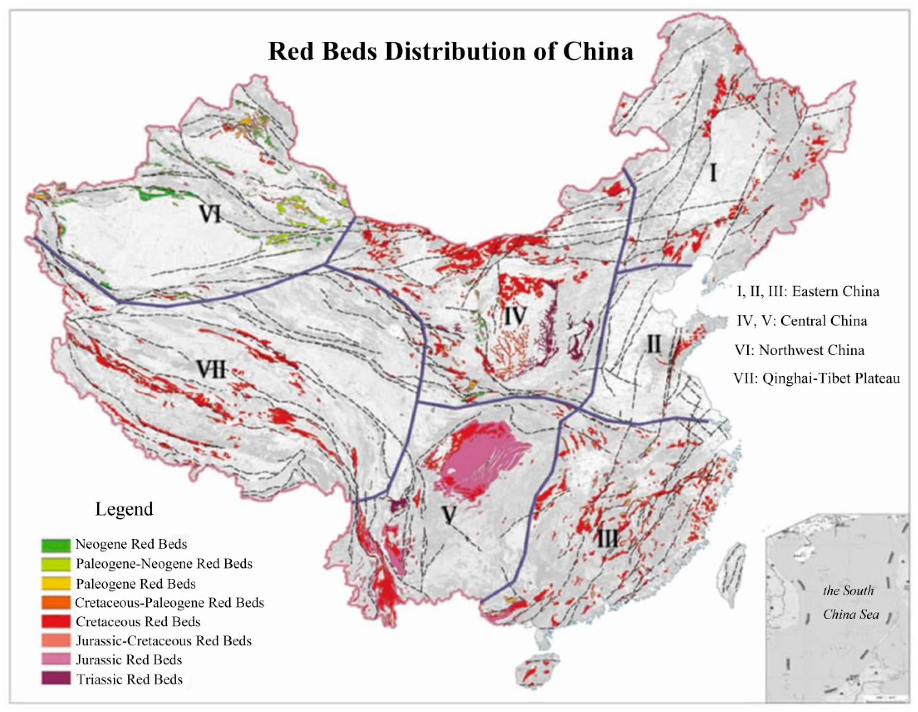
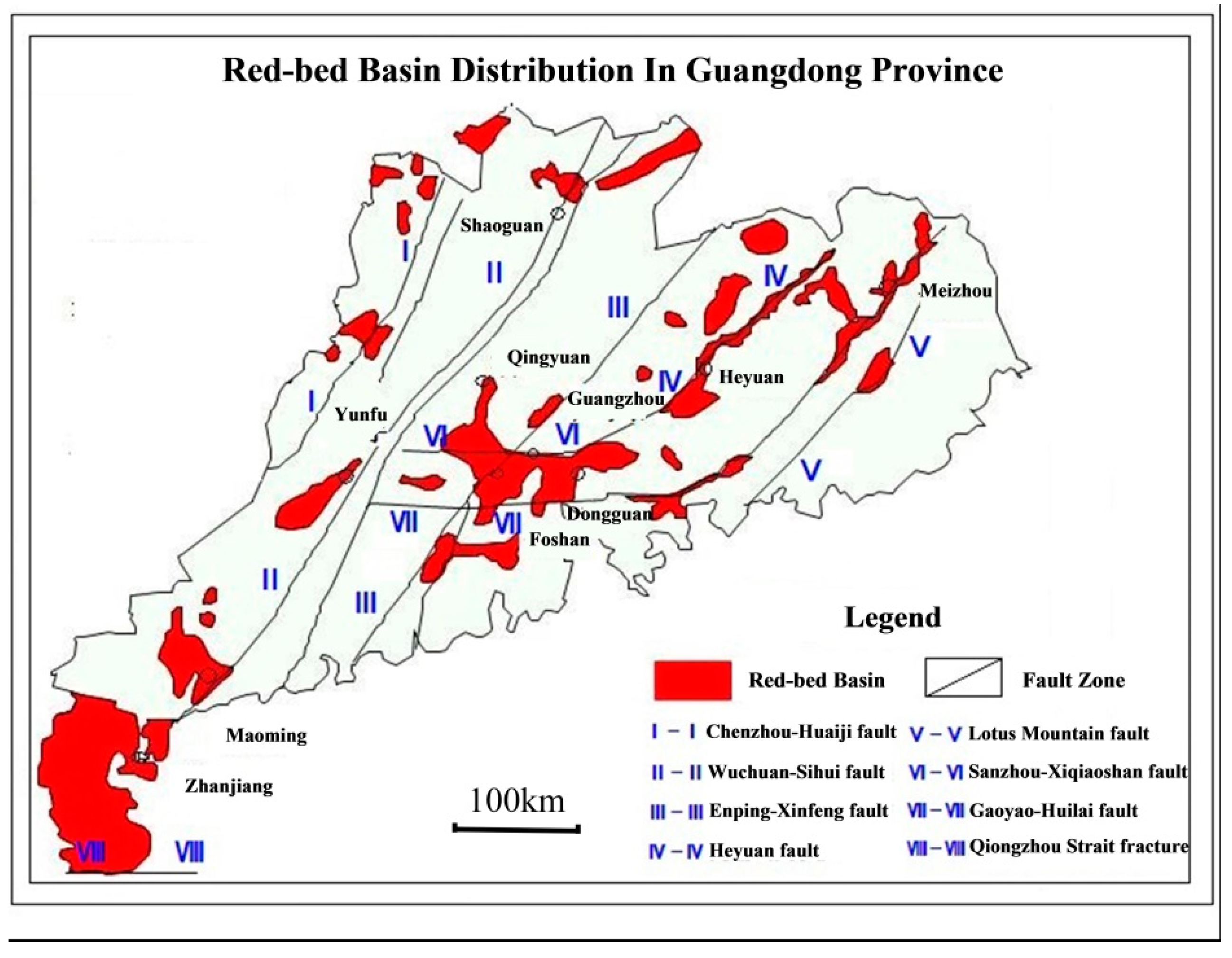
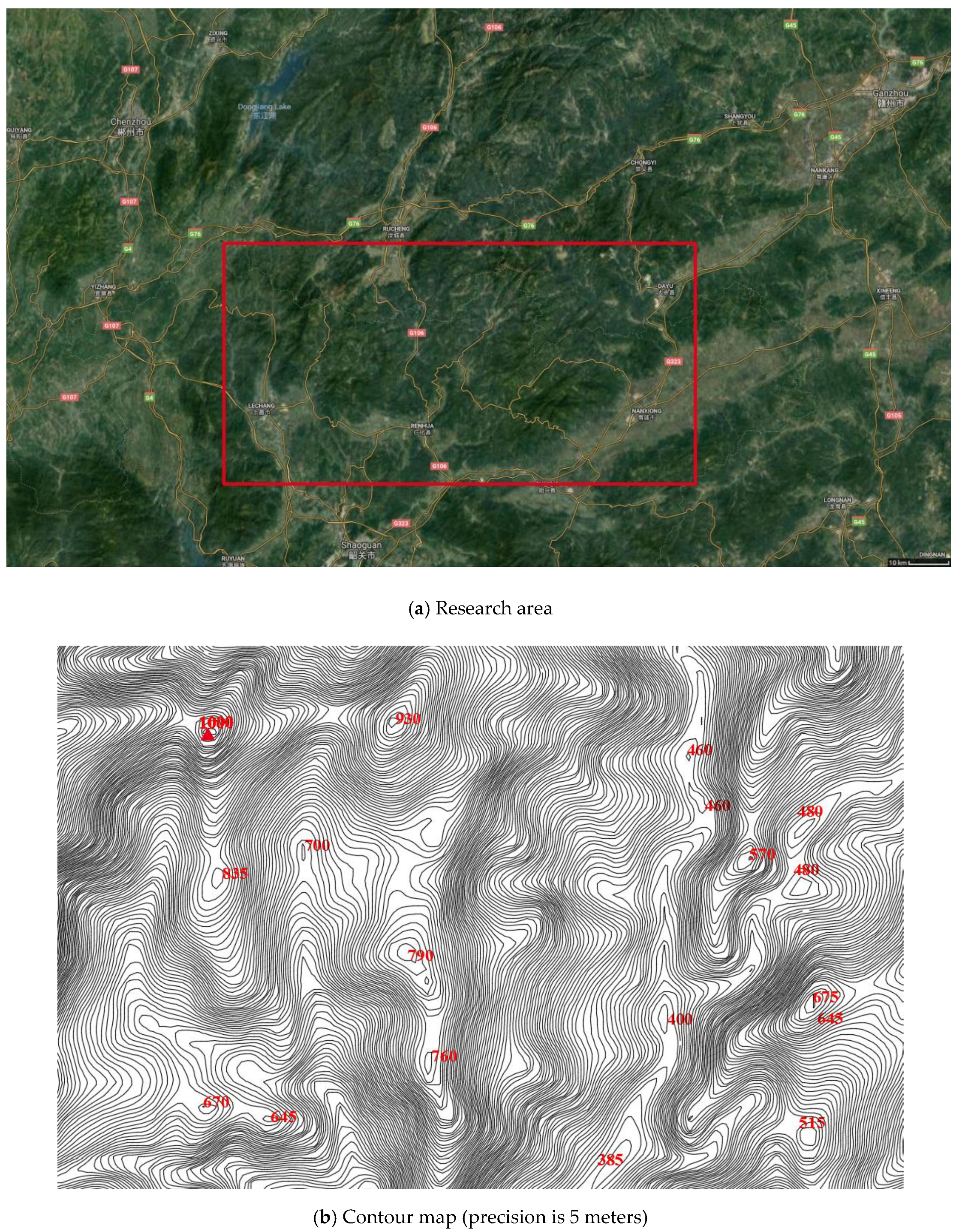
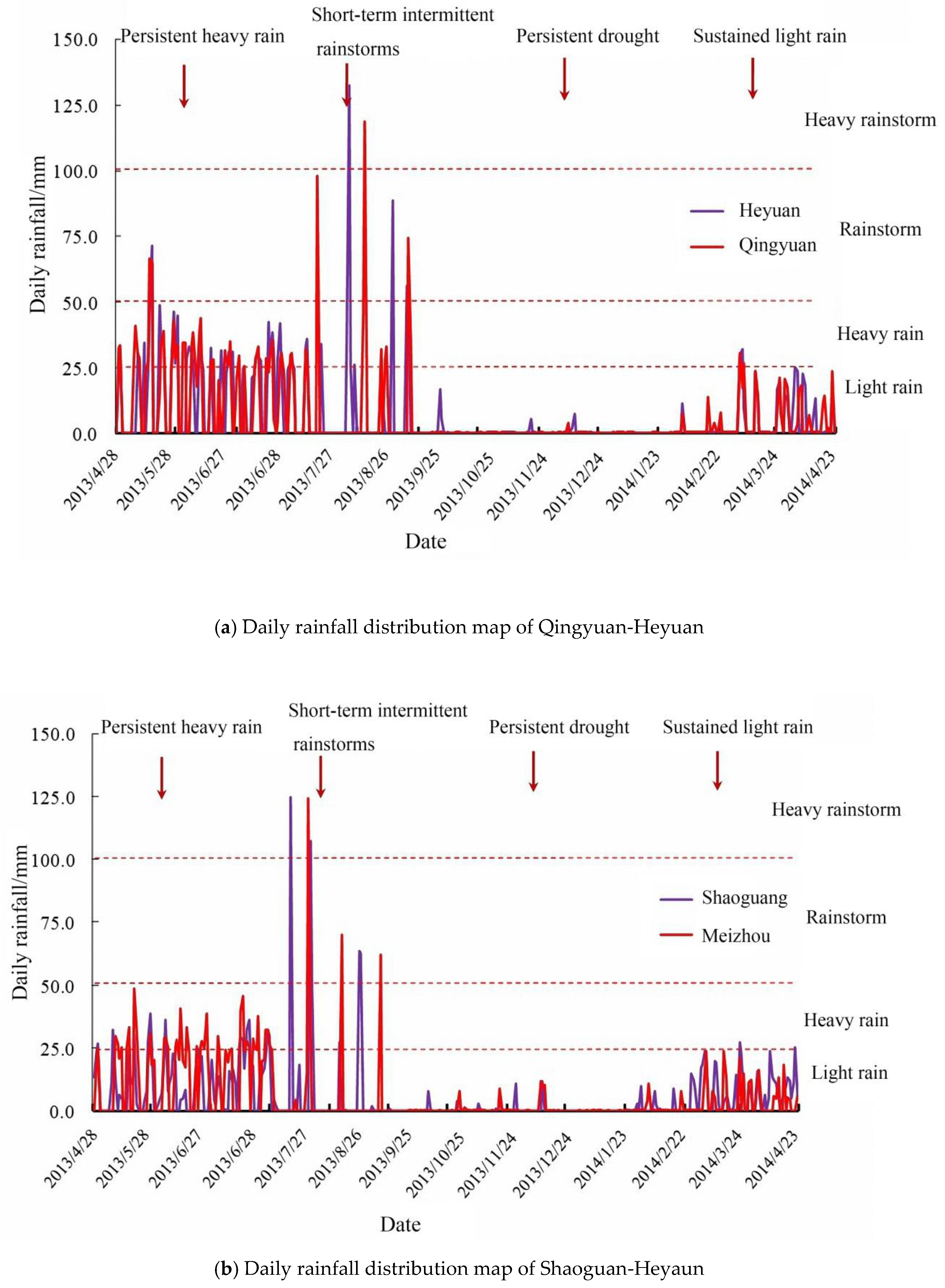
2. Geological Background of Red-Bed Formation in South China
- A basin surrounded by mountains, which specifically refers to a red-bed basin surrounded by mountainous areas and faults that bound the basin.
- Danxia landform, in which several vertical structural planes are well developed, cutting the rock bed into columnar or platelike structures.
- Red-bed hill zone, which refers to hills with moderate slopes that are made of rock beds consisting of sandstone or shale.
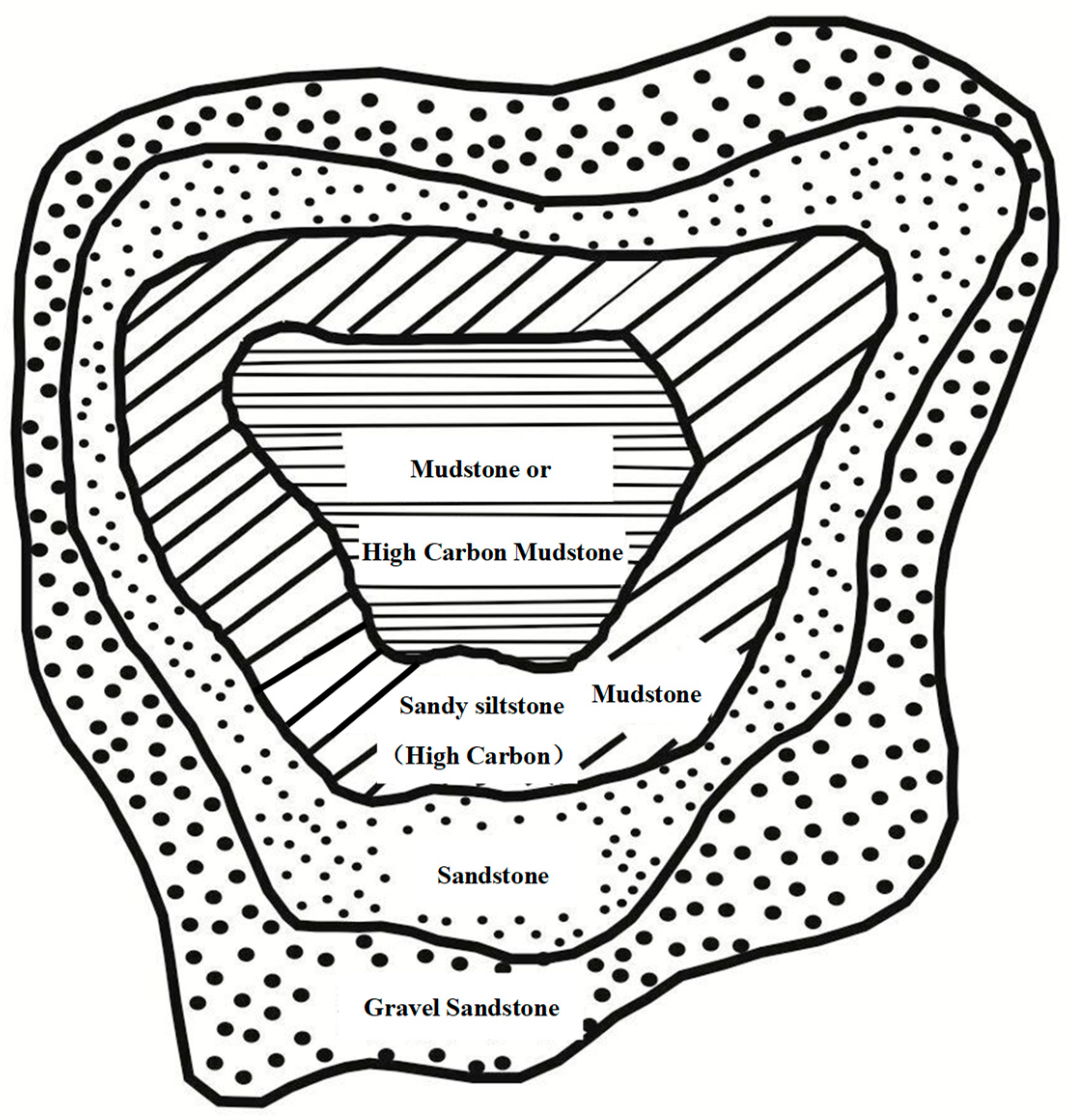
- Center plain zone [1], which refers to the central part of a red-bed basin. This zone is generally formed by the sedimentation of fine-grained clastic lacustrine facies and alluvial flat facies. The lamellar-structured red beds were formed with small dip angles and were slightly influenced by tectonic movement.
3. Inner Structures of Red Beds in South China
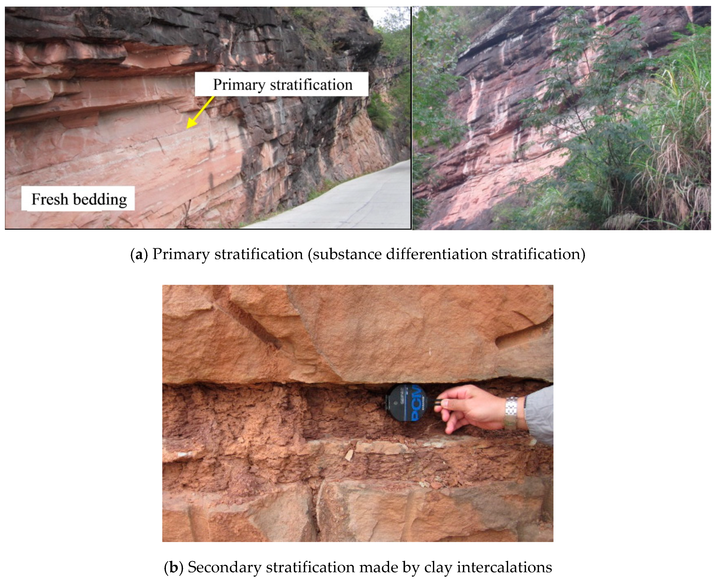
3.1. Red-Bed Litho-Structural Facies in South China
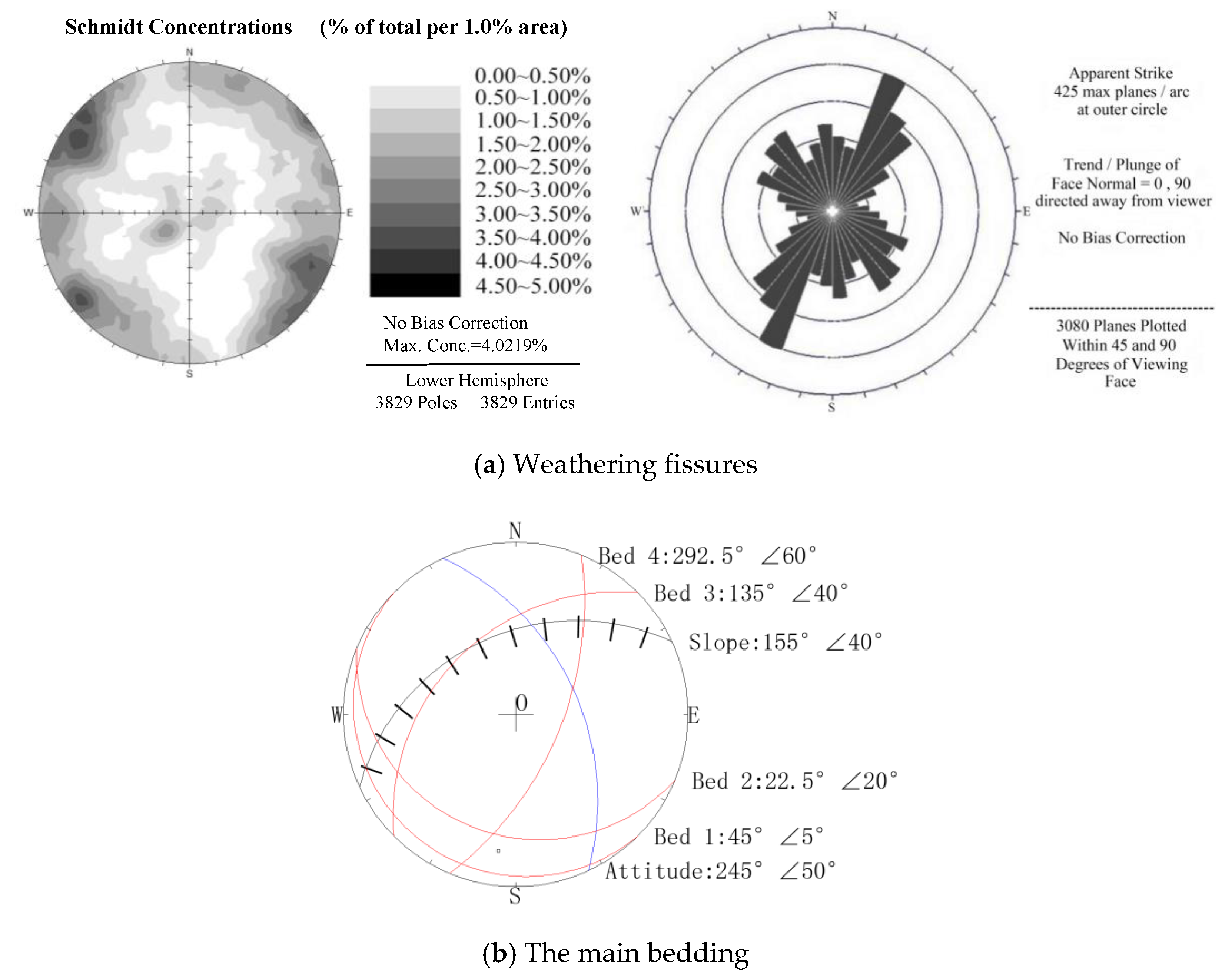
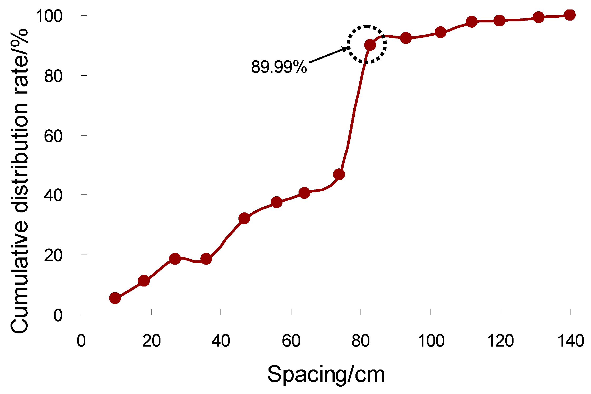
3.2. Structural Types of Rock Mass in Red Beds in South China
4. Results and Discussion
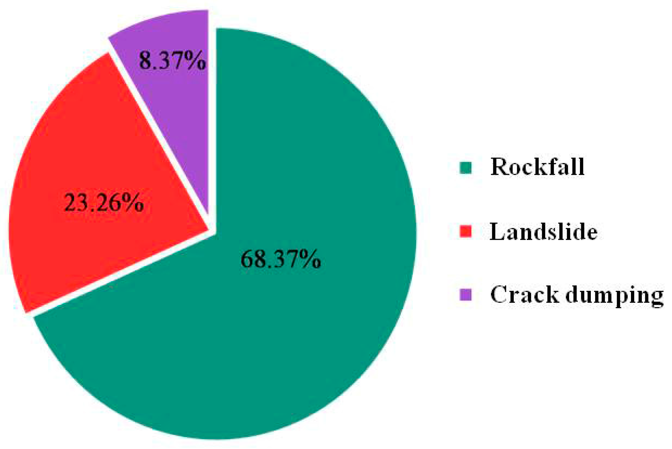
4.1. Disastrous Characteristics and Failure Mode of Red-Bed Slopes in South China
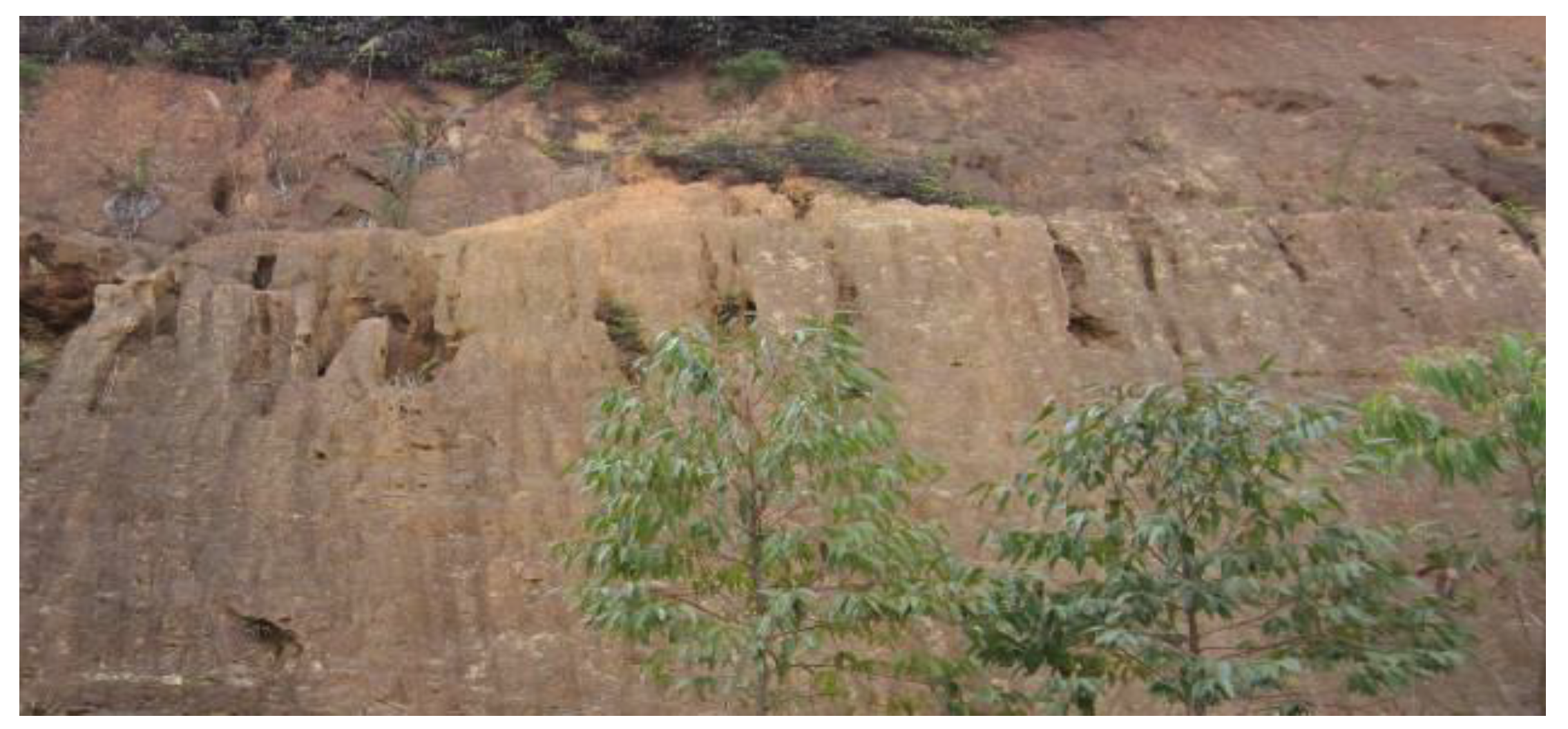
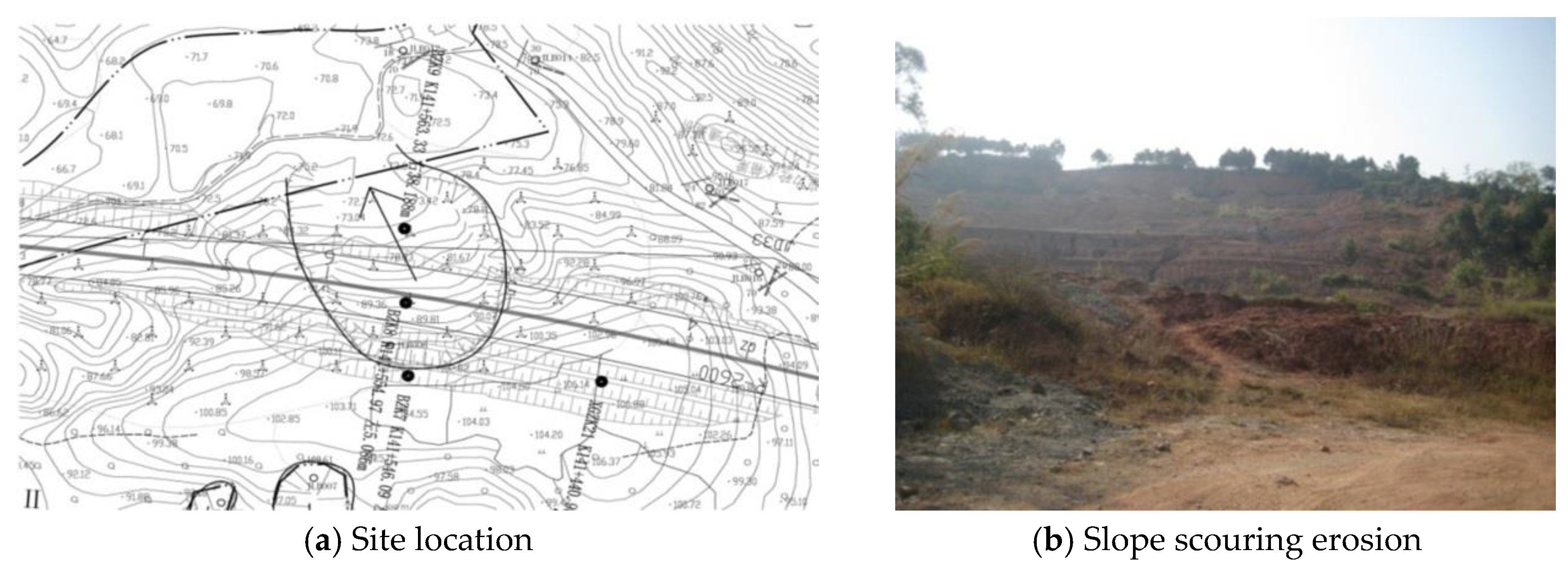
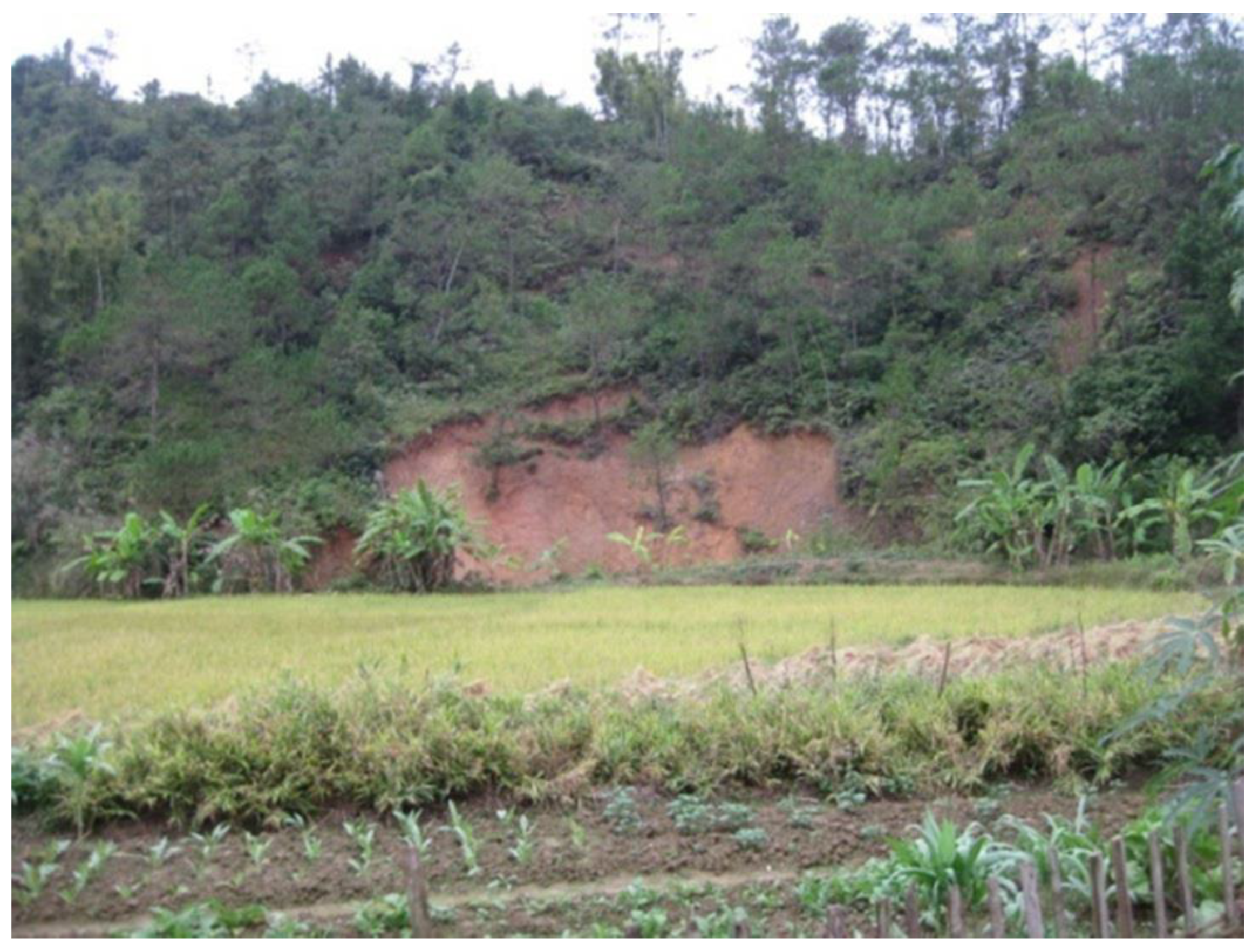
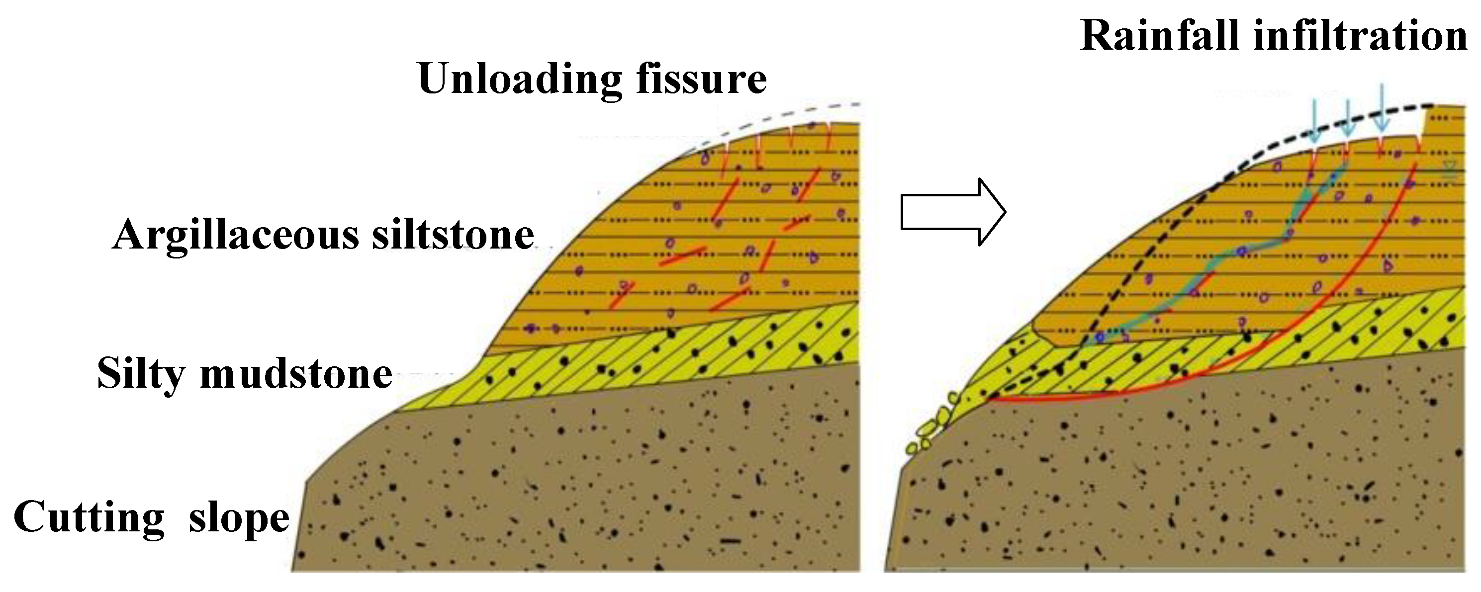
4.1.1. Weathering and Slope Scouring
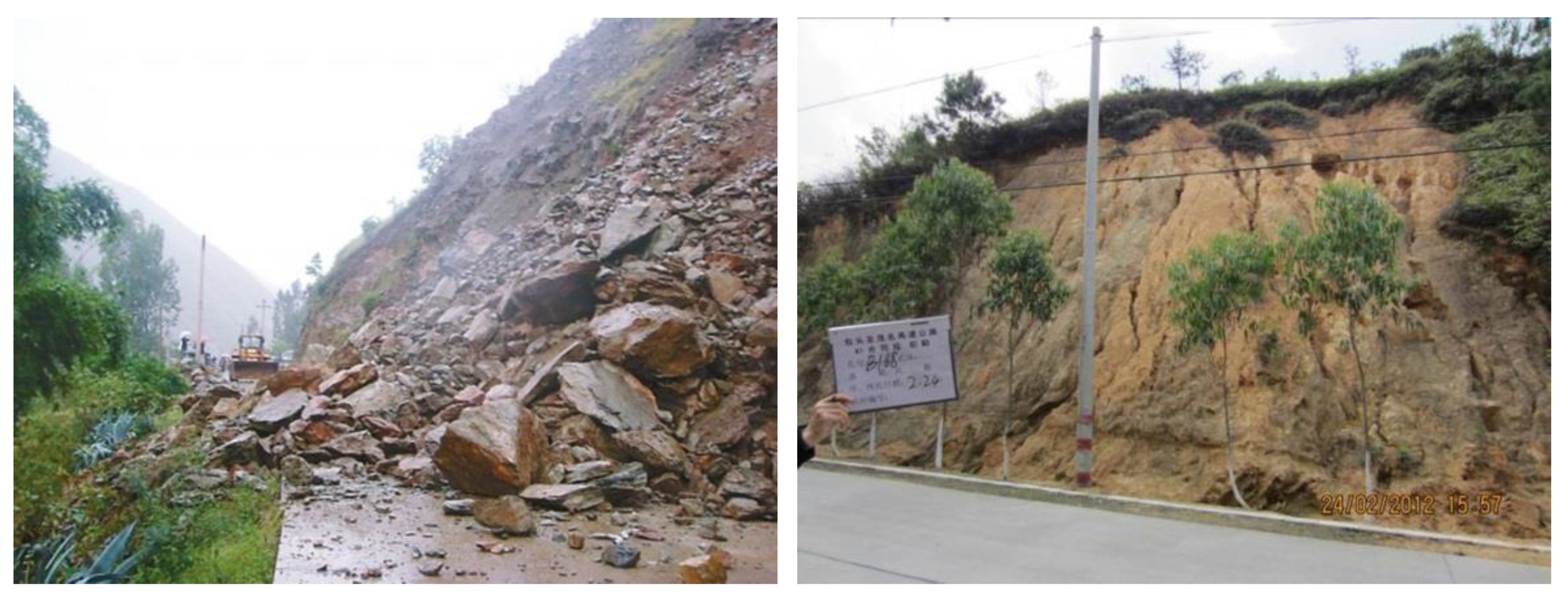
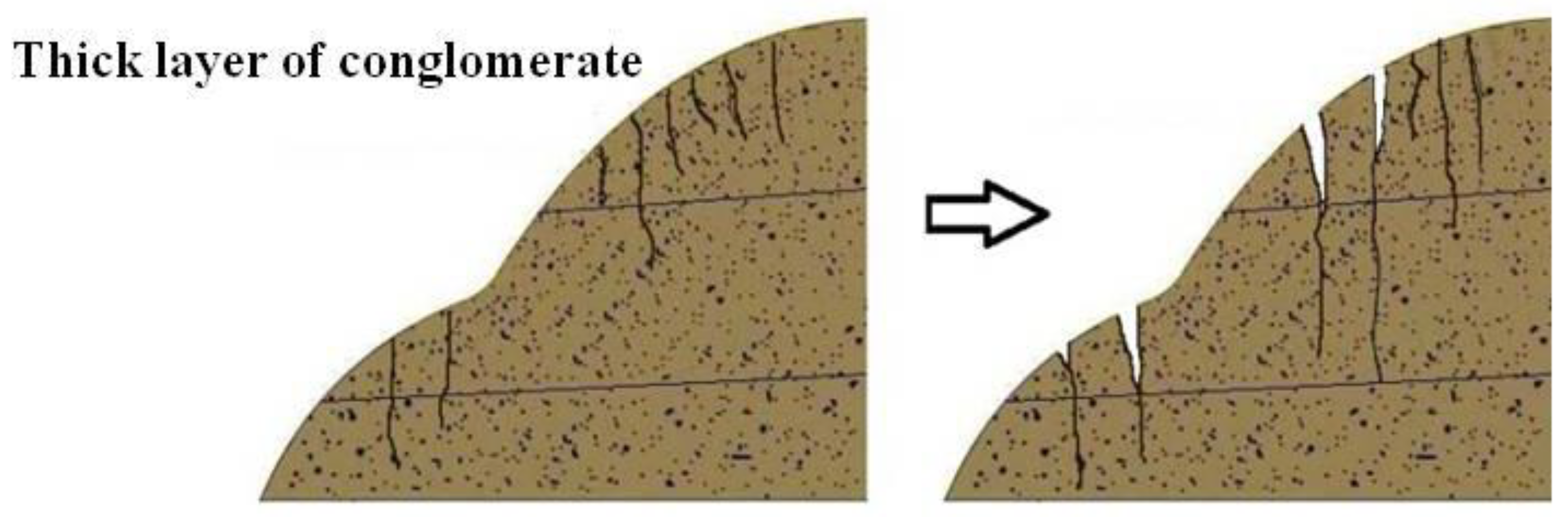
4.1.2. Rock Falls
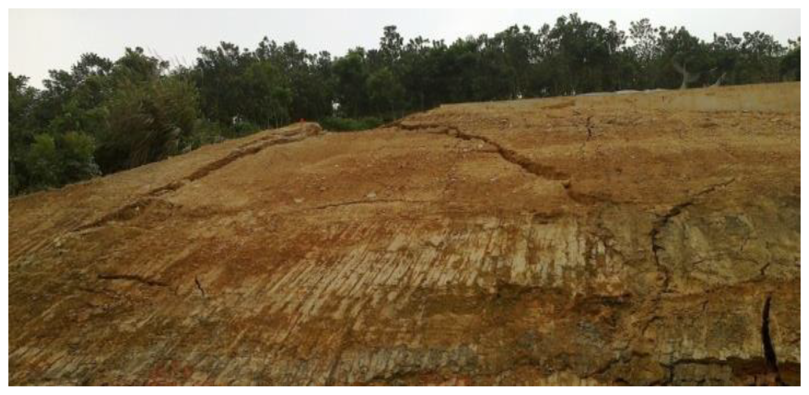
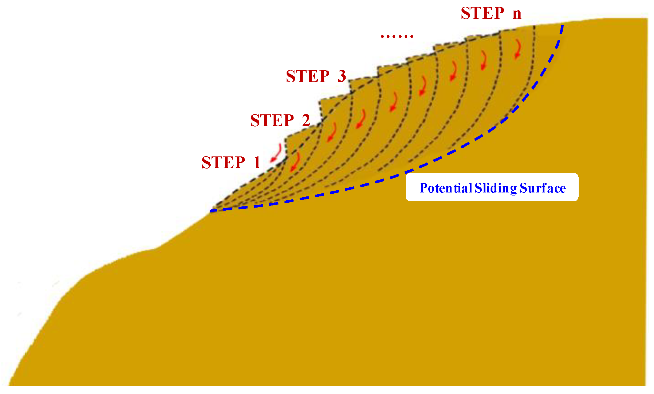
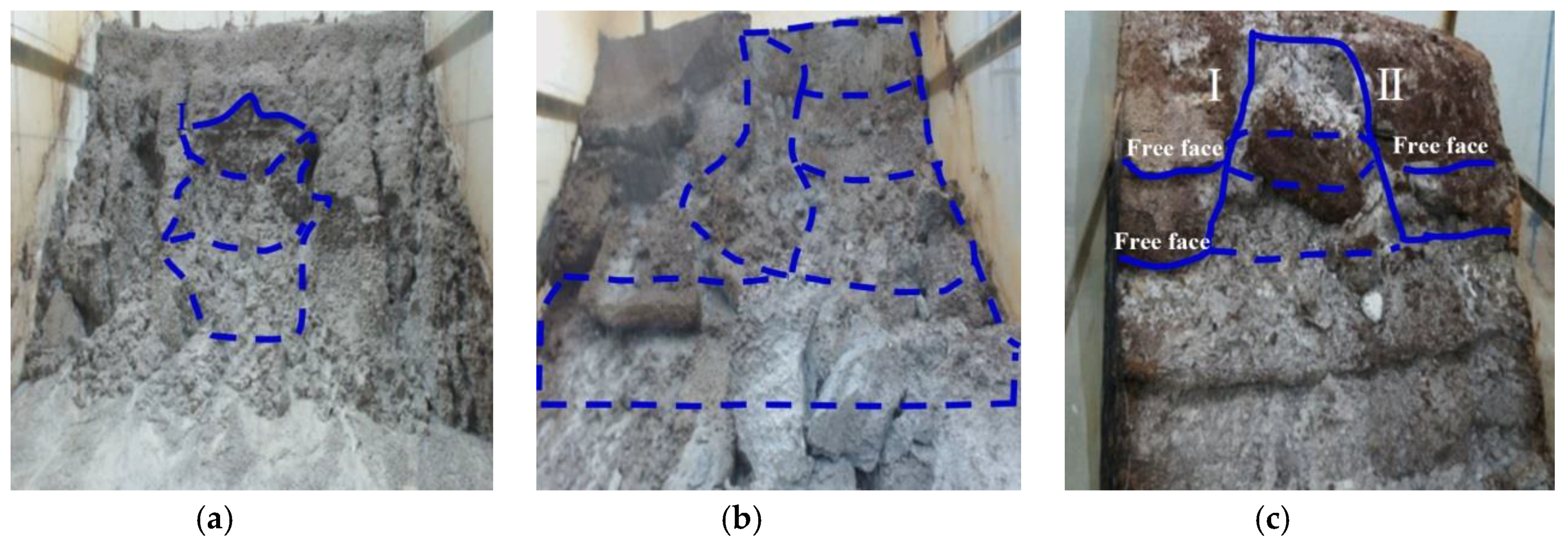
4.1.3. Landslide
4.1.4. Toppling
5. Conclusions
Author Contributions
Funding
Conflicts of Interest
References
- Peng, H.; Wu, Z.C. A Preliminary Study on the characteristics and the distribution of red beds. Acta Sci. Nat. Univ. Sun Yat-Sen 2003, 42, 109–113. [Google Scholar]
- Liu, X.M. Research on Slaking Properties of Red Beds Soft Rock and Dynamic Deformation Properties of Embankment. Ph.D. Thesis, Hunan University, Changsha, China, 2006. [Google Scholar]
- Yin, Y.P. Recent catastrophic landslides and mitigation in China. J. Rock Mech. Geotech. Eng. 2011, 3, 10–18. [Google Scholar] [CrossRef]
- Cheng, Q.; Kou, X.B.; Huang, S.B.; Zhou, Y.J. The distributes and geologic environment characteristics of red beds in China. J. Eng. Geol. 2014, 12, 34–40. [Google Scholar]
- Yin, Y.P.; Huang, B.L.; Wang, W.P.; Wei, Y.J.; Ma, X.H.; Ma, F.; Zhao, C.J. Reservoir-induced landslides and risk control in Three Gorges Project on Yangtze River, China. J. Rock Mech. Geotech. Eng. 2016, 8, 577–595. [Google Scholar] [CrossRef]
- Wang, J.; Cao, Y.; Liu, K.; Costanzo, A.; Feely, M. Diagenesis and evolution of the lower Eocene red-bed sandstone reservoirs in the Dongying Depression, China. Mar. Pet. Geol. 2018, 94, 230–245. [Google Scholar] [CrossRef]
- Hu, Q.J.; Huang, C.; Cai, Q.J. Multiple-factor analysis of fluid structure interaction about the stability of red bed mudstone slope. Electron.-J. Geotech. Eng. 2014, 19G, 1421–1432. [Google Scholar]
- Zhou, Y.H.; Zhou, C.Y.; Liu, Z.; Yang, X.; Su, D.L.; Du, Z.C.; Liu, W. Model test for red-bed rock slope with weak intercalation affected by rainfall and its instability catastrophe model. Electron.-J. Geotech. Eng. 2016, 21, 3887–3903. [Google Scholar]
- Allan, P. The weathering rates of some sand stone cliffs central weald. Earth Surf. Process Landf. 1991, 16, 83–91. [Google Scholar]
- Robert, Y.; Ann, Y. Sandstone Landform; Springer: Berlin/Heidelberg, Germany, 1992; pp. 1–122. [Google Scholar]
- Turkingtong, A.V.; Paradise, T.R. Sandstone weathering: A century of research and innovation. Geomorphology 2005, 67, 229–253. [Google Scholar]
- Warke, P.A.; Mckinley, J.; Smith, B.J. Variable weathering response in sandstone: Factors controlling decay sequences. Earth Surf. Process Landf. 2006, 31, 715–735. [Google Scholar] [CrossRef]
- Handrij, H.; Václav, C.; Andrew, J. Sandstone Landscapes; Nakladatelství Academic: Praha, Czech Republic, 2007; pp. 12–125. [Google Scholar]
- Gu, D.Z. Rock Engineering Geological Mechanics Foundation; Science Press: Beijing, China, 1979. [Google Scholar]
- Ju, H.Y.; Gu, R.J. Geologic feature and engineering geological problems of red beds in South China. Shanghai Geol. 1983, 3, 1–16. [Google Scholar]
- Sun, G.Z. On the theory of structure-controlled rockmass. J. Eng. 1993, 1, 14–18. [Google Scholar]
- Troalen, J.P. Ultrastructural approach to the behaviour of geomaterials: Clayey geomaterials. Bull. Int. Assoc. Eng. Geol. 1994, 4, 73–83. [Google Scholar] [CrossRef]
- Hillier, R.D.; Williams, B.P.J. Sedimentation and tectonies: The marine Siluria-basal lower Old Red Sandstone transition in southwest Wales. Geol. J. 2004, 39, 237–256. [Google Scholar] [CrossRef]
- Hu, H.T.; Zhao, X.Y. Studies on rockmass structure in slope of red bed in China. Geotech. Eng. 2006, 28, 689–694. [Google Scholar]
- Zhou, C.Y.; Zhu, F.X.; Zheng, L. Research on saturation test and softening critical phenomena of soft rocks. Rock Soil Mech. 2010, 31, 1709–1715. [Google Scholar]
- Zhou, C.Y.; Zhu, F.X. An elasto-plastic damage constitutive model with double yield surfaces for saturated soft rock. Int. J. Rock Mech. Min. Sci. 2010, 47, 385–395. [Google Scholar] [CrossRef]
- Yamashita, I.; Surinkum, A.; Wada, Y.; Fujihara, M.; Yokoyama, M.; Zaman, H.; Otofuji, Y. Paleomagnetism of the Middle-Late Jurassic to Cretaceous red beds from the Peninsular Thailand: Implications for collision tectonic. J. Asian Earth Sci. 2011, 40, 784–796. [Google Scholar] [CrossRef]
- Yang, Z.F.; Yue, Z.Q.; Li, L.H. Design, construction and mechanical behavior of relics of complete large Longyou rock caverns carved in argillaceous siltstone ground. J. Rock Mech. Geotech. Eng. 2011, 3, 131–152. [Google Scholar] [CrossRef]
- Li, X.; Tan, R. Superficial Deformation and Failure Modes of Small and Medium Scale Slopes in Red Bed Sichuan Basin. In Proceedings of the 3rd International Conference on Transportation Engineering, Chengdu, China, 23–25 July 2011; pp. 2050–2055. [Google Scholar]
- Lu, H.F.; Liu, Q.S.; Chen, C.X.; Wu, Y.X.; Li, J.L. Experimental study on mechanical characteristic of weak interlayer in red-bed soft rock slope. Energy Educ. Sci. Technol. Part A Energy Sci. Res. 2012, 30, 467–474. [Google Scholar]
- Chen, J.; Dai, F.C.; Xu, L.; Chen, S.; Wang, P.F.; Long, W.; Shen, N.Q. Properties and microstructure of a natural slip zone in loose deposits of red beds, southwestern China. Eng. Geol. 2014, 183, 53–64. [Google Scholar] [CrossRef]
- Akintunde, O.M.; Knapp, C.C.; Knapp, J.H. Tectonic significance of porosity and permeability regimes in the red beds formations of the South Georgia Rift Basin. Tectonophysics 2014, 632, 1–7. [Google Scholar] [CrossRef]
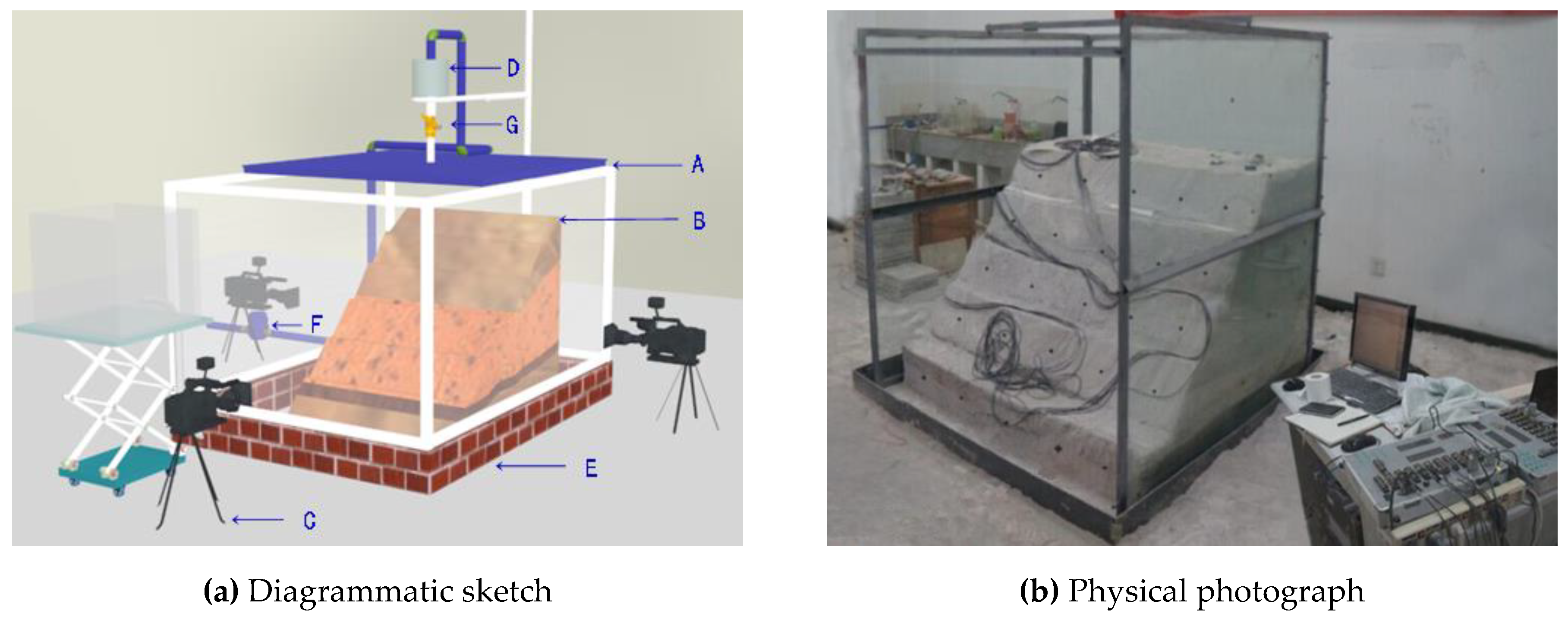
- Gao, Q.; Zhang, Q.Y.; Zhang, X.T.; Zhang, L.Y. Geomechanical Model Test and Energy Mechanism Analysis of Zonal Disintegration in Deep Surrounding Rock. Geosciences 2018, 8, 237. [Google Scholar] [CrossRef]
- Zhang, Z.Y.; Wang, S.T.; Wang, L.S. Engineering Geological Analysis Principle; Geological Publishing House: Beijing, China, 1994. [Google Scholar]
- GB50021. Code for Geotechnical Engineering Investigation; China Building Industry Press: Beijing, China, 2001. [Google Scholar]
- Li, Z.Y.; Zou, J.R.; Xie, Q. Studies on engineering geologic and systematic clustering on roadcuts and slopes in red beds. Geotech. Investig. Surv. 2002, 2, 5–7. [Google Scholar]
- Chi, E.A.; Tao, T.J.; Zhao, M.S.; Kang, Q. Failure Mode Analysis of Bedding Rock Slope Affected by Rock Mass Structural Plane. Appl. Mech. Mater. 2014, 602–605, 594–597. [Google Scholar] [CrossRef]
- Sun, S.R.; Sun, H.Y.; Wang, Y.J.; Wei, J.H.; Liu, J.; Kanungo, D.P. Effect of the combination characteristics of rock structural plane on the stability of a rock-mass slope. Bull. Eng. Geol. Environ. 2014, 73, 987–995. [Google Scholar] [CrossRef]
- Zhong, W.; Tan, Z.Y.; Qiao, L. Stability Analysis of Rock Slope Based on Preferred Structural Plane. Adv. Mater. Res. 2011, 243–249, 2254–2258. [Google Scholar] [CrossRef]
- Guo, Y.C.; Xie, Q.; Wen, J.Q. Engineering criterion of structure-stability of soft rocks of redbeds. Hydrogeol. Eng. Geol. 2010, 6, 86–90. [Google Scholar]
- Cheng, C.; Zhou, A.G.; Zhou, J.W. Landscape characteristics and causes process of Danxia landforms in Baishishan of Guiping city, Guangxi Province. Earth Sci. J. China Univ. Geosci. 2013, 38, 641–648. [Google Scholar]
- Li, X.; He, Q.C.; Dong, Y.; Cao, X.J.; Wang, Z.Y.; Duan, X.M. An analysis of characteristics and evolution of Danxia Landform in the south of Chishui County, Guizhou. Acta Geosci. Sin. 2013, 34, 501–508. [Google Scholar]
- Su, T.M.; Zhang, Y.G.; Zhang, T.Z.; Liu, Y.L. Rock falls in horizontal strata due to differential weathering. Eng. Geol. Soc. Territ. 2015, 2, 1745–1751. [Google Scholar]
- Dong, J.Y.; Yang, J.H.; Wu, F.Q.; Wang, D.; Yang, G.X. Research on collapse of high cutting slope with horizontal soft-hard alternant strata in Three Gorges reservoir area. Rock Soil Mech. 2010, 31, 151–157. [Google Scholar]
- Lin, Z.Y. Geotechnical Engineering Reconnaissance and Design Manual; Liaoning Science and Technology Press: Shenyang, China, 1996. [Google Scholar]
- Yang, X. Study on the environment effect model of the red-bed soft rock slope. Ph.D. Thesis, Sun Yat-sen University, Guangzhou, China, 2015. [Google Scholar]
- Andrew, S.G.; Heather, A.V. The nature and pattern of debris liberation by salt weathering: A laboratory study. Earth Surf. Process Landf. 1995, 20, 437–449. [Google Scholar]
- Kevin, H.; Alida, H. Weathering by wetting and drying: Some experimental results. Earth Surf. Process Landf. 1996, 21, 365–376. [Google Scholar]
- Phillips, J.D.; Luckow, K.; Marion, D.A.; Adams, K.R. Rock fragment distributions and regolith evolution in the Ouachita mountains, Arkansas, USA. Earth Surf. Process Landf. 2005, 30, 429–442. [Google Scholar] [CrossRef]
- Niemann, W.L. Lessons learned from rates of mudrock undercutting measured over two time periods. Environ. Eng. Geosci. 2009, 15, 117–131. [Google Scholar] [CrossRef]
- Chengdu Railway Bureau. Plastering Prevent of Clay Rock Slope Weathering Flaking; 1963 Railway Science and technology papers report anthology the 11 series (Engineering Geology and Roadbed Engineering); China Railway Press: Beijing, China, 1965.
- Yang, Z.C.; Zhang, J.Y.; Zhou, D.P. Study on fast weathering characteristics of red bed mudstone slope. J. Rock Mech. Eng. 2006, 25, 275–283. [Google Scholar]
- Pritchard, M.A.; Savigny, K.W. Heather Hill landslide: An example of a large scale toppling failure. Can. Geotech. J. 1989, 26, 737–742. [Google Scholar]
- Phien-Wej, N.; Nutalaya, P.; Aung, Z.; Tang, Z.B. Catastrophic landslides and debris flows in Thailand. Bull. Int. Assoc. Eng. Geol. 1993, 48, 93–100. [Google Scholar] [CrossRef]
- Zheng, Y.R.; Chen, Z.Y.; Wang, G.X.; Ling, T.Q. Slope and Landslide Management; People’s Communication Press: Beijing, China, 2010. [Google Scholar]
- Xu, W.Y.; Zhang, Q.; Zhang, J.C.; Wang, R.B.; Wang, R.K. Deformation and control engineering related to huge landslide on left bank of Xiluodu reservoir, South-West China. Eur. J. Environ. Civ. Eng. 2013, 17 (Suppl. 1), 249–268. [Google Scholar] [CrossRef]
- Zhang, M.; Yin, Y.P.; Huang, B.L. Mechanisms of rainfall-induced landslides in gently inclined red beds in the eastern Sichuan Basin, SW China. Landslides 2015, 12, 973–983. [Google Scholar] [CrossRef]
- Gong, Q.H. DEM and GIS based analysis of topographic and geomorphologic factors of shallow landslide in red soil hilly region of South China. Int. J. Earth Sci. Eng. 2014, 7, 393–399. [Google Scholar]
- Cruden, D.M.; Varnes, D.J. Landslide types and processes. InLandslides: Investigation and Mitigation; Turner, A.K., Shuster, R.L., Eds.; Transp Res Board, Spec Rep 247; National Academy Press: Washington, DC, USA, 1996; pp. 36–75. [Google Scholar]
- Tang, M.G.; Xu, Q.; Huang, X.B.; Xu, K.X.; Cheng, W.M.; Wang, K. Recognition and Genetic Mechanism of Sanmashan Deep-Seated Landslide, Three Gorges Reservoir Area, China. Eng. Geol. Soc. Territ. 2015, 2, 587–591. [Google Scholar]
- Zhang, S.; Xu, Q.; Hu, Z. Effects of rainwater softening on red mudstone of deep-seated landslide, Southwest China. Eng. Geol. 2016, 204, 1–13. [Google Scholar] [CrossRef]


| The Type and Class of Rock Mass Structure | Structural Feature | Engineering Geological Evaluation | Rock Mass Structure Diagram | |
|---|---|---|---|---|
| Thick-layered hard rock mass structure | Global-layered | Complete rock mass consisting of mega-thick glutenite with a layer spacing of more than 150 cm; no more than one set of orthogonal steep dip joints developed in the inner zone | Hard and locally uniform structure with primary closure joints in majority; mega-block is the structural morphology with good stability but prone to local collapse and slide |  |
| Block-layered | Relatively complete rock mass consisting of thick-layered glutenite with a layer spacing of between 100 and 150 cm; structural plane developed with a spacing of between 80 and 100 cm | Relatively hard structure with a block or cylinder as the main structural morphology; relatively stable with cracks developed along the structural plane; prone to collapse and slide |  | |
| Thick-layered soft–weak rock mass structure | Composed of thick-layered soft–weak rock mass deposits or consists of thick layers of intensively weathered conglomerates (more than 20 m in thickness) | Relatively weak slope; developed structural plane; rock thickness of 0.5 to 15 m; prone to collapse and slide |  | |
| Thick-layered hard rock mass structure with soft–weak rock mass | With soft–weak interlayer (including clayey layer) | Hard rock mass, such as thick-layered glutenite, with a thin-layered weak clayey rock mass, which includes a clayey layer of soft–weak rock mass formed by the wet–dry cycling and weathering | The upper hard rock mass can easily slide horizontally along the plane of the soft–weak rock mass or collapse to a free face |  |
| With soft–hard interbedded rock mass | Mega-thick-layered or thick-layered hard rock mass with a soft–hard interbedded rock mass below, such as sand mud and sand shale | The upper hard rock mass can easily slide horizontally along the plane of the soft–weak rock mass or collapse to a free face |  | |
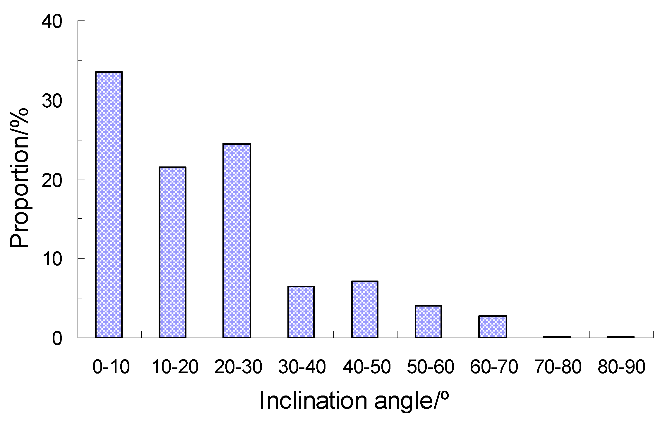
| Soft–hard interbedded rock mass structure | Soft–hard interbedded rock mass with different thicknesses with a layer spacing ranging from 10 to 50 cm; developed structural planes with thicknesses ranging from 2 to 9 cm and a density of 2–7 per meter (15–20 per meter in some local parts) | The density of the structural planes near the fault fracture zone is the highest; easily prone to a cutting landslide |  | |
© 2019 by the authors. Licensee MDPI, Basel, Switzerland. This article is an open access article distributed under the terms and conditions of the Creative Commons Attribution (CC BY) license (http://creativecommons.org/licenses/by/4.0/).
Share and Cite
Zhou, C.; Yang, X.; Liang, Y.; Du, Z.; Liu, Z.; Huang, W.; Ming, W. Classification of Red-Bed Rock Mass Structures and Slope Failure Modes in South China. Geosciences 2019, 9, 273. https://doi.org/10.3390/geosciences9060273
Zhou C, Yang X, Liang Y, Du Z, Liu Z, Huang W, Ming W. Classification of Red-Bed Rock Mass Structures and Slope Failure Modes in South China. Geosciences. 2019; 9(6):273. https://doi.org/10.3390/geosciences9060273
Chicago/Turabian StyleZhou, Cuiying, Xu Yang, Yanhao Liang, Zichun Du, Zhen Liu, Wei Huang, and Weihua Ming. 2019. "Classification of Red-Bed Rock Mass Structures and Slope Failure Modes in South China" Geosciences 9, no. 6: 273. https://doi.org/10.3390/geosciences9060273
APA StyleZhou, C., Yang, X., Liang, Y., Du, Z., Liu, Z., Huang, W., & Ming, W. (2019). Classification of Red-Bed Rock Mass Structures and Slope Failure Modes in South China. Geosciences, 9(6), 273. https://doi.org/10.3390/geosciences9060273