1. Introduction
Variations in the atmospheric composition and climatic changes throughout geologic time were crucial not only for the birth of life on Earth but also for acting as the trigger of several episodes of mass extinction and the development of new species after biological readjustments faced new environmental conditions. More recently over the historic human time-scale, the eruption of large carbon dioxide (CO2) and dust emissions generated by recurrent volcanic eruptions affected the climate of the entire Earth.
At the present time, carbon dioxide is released not only from natural sources like biological and volcanic activities but also by a strong anthropogenic action including fossil fuel combustion for transport, industry, and energy generation.
Geology shows that the CO2 natural emissions are commonly associated with Earth endogenic activity since the beginning of geological times. This endogenic sourced CO2 could reach the Earth surface by natural sequestration in buried rock formations also occur in some specific regions depending on the geological framework. In some areas of the world, large accumulations of CO2 have been found in geologic traps associated both with or without hydrocarbons.
In Brazil, significant CO
2 accumulations were not identified before the first decade of this century. Since 2006, large volumes of carbon dioxide and fluids with high CO
2 content have been discovered in some of the oil fields located in the pre-salt section of Santos Basin. In one of the drilled prospects, carbon dioxide was found to be up to 80% in the gas cap. This is an unusual fluid association for this petroleum province, as a CO
2-rich gas cap with condensate is on top of a heavy-oil (18° API) filled reservoir, whereas in nearby fields with apparently similar geological settings the CO
2 content is much lower, and oils are commonly lighter at 29° to 30° API [
1].
High concentrations of CO
2 represent a major challenge to field developments not only because of technical difficulties related with the CO
2 separation from the hydrocarbons in case of large production rates but also because of the integrity risk of facilities as fast corrosion processes can reduce the lifetime or cause collapse of production pipes and other equipment [
2]. Another important issue is related with the CO
2 disposal as international protocols towards the reduction of the emissions of gases linked to the greenhouse gas effect (GHG), especially after COP XXI, do not allow any CO
2 atmospheric release.
Disposal of CO2 in the oil reservoirs during the production as an enhanced oil recovery (EOR) technique or after its depletion for CO2 sequestration are solutions to minimize emissions. However, in both cases, dedicated handling facilities will be required, adding to the expense (capital and operating costs) of the project.
In addition to health, safety, and environment (HSE) implications, the CO2 prediction in petroleum reservoirs is very important to enhance our knowledge of the petroleum system in exploration and de-risk new ventures. The interaction of CO2 with other fluids and with host rocks can create important changes in the physical-chemical properties of the petroleum. Evaporative fractionation after a latter CO2 arrival could explain the fluid stratification found in some petroleum reservoirs. Diagenetic processes due to this CO2 arrival could also affect reservoir perm-porosity properties.
Although CO
2 occurrences in petroleum reservoirs are common worldwide, usually they are of low concentrations of less than 5%. Occurrences in the order of 20% correspond to less than 1% of all cases [
3].
In the hydrocarbon prolific Santos Basin, the amount of CO2 proved in several drilled prospects is very heterogeneous even in adjacent areas with very similar geologic contexts.
That is the case of the almost twin prospects of Tupi (Lula field) which has low CO
2 content and Jupiter where a concentration of 80% of CO
2 within the total gases is reported [
1]. The origin of this gas from Earth’s mantle has already been proven by the isotopic analyses of noble gases [
4].
Several hypotheses have been proposed to explain this mantle sourced carbon dioxide in hydrocarbon reservoirs, namely regional crustal thinning, deep-seated faults, high fault density, igneous intrusions, among others [
3,
4,
5,
6,
7].
The combined geological, geophysical setting, and gaseous geochemistry allow us to infer that the geodynamic evolution of São Paulo Plateau/Santos Basin area had several episodes of intense upwelling of magmatic material sourced from the mantle throughout late Cretaceous and Lower Eocene times as generally recognized in the regional geology.
In this paper, we present a hypothesis to explain the processes that control the geographic distribution of large volumes of CO2 in the São Paulo Plateau region. This hypothesis can also provide a good explanation for the differences in CO2 contents found in Jupiter structure and the neighbor discoveries.
3. Results
3.1. Regional Setting
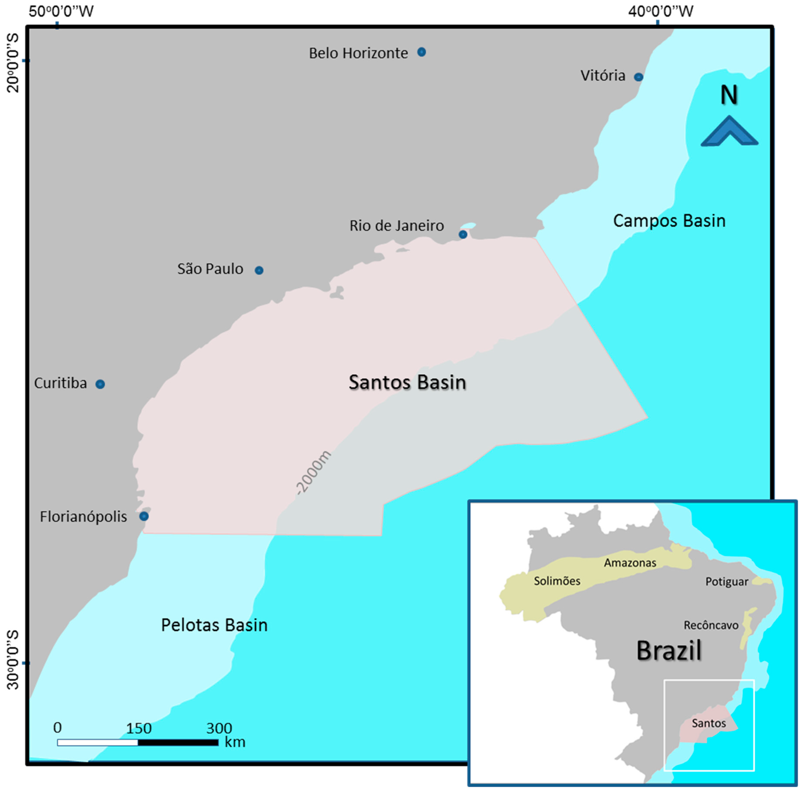
The Santos Basin situated offshore southern Brazil between Campos and Pelotas Basins, offshore the states of Rio de Janeiro, São Paulo and Parana (
Figure 1), is one of a series of basins located at the continental margin, the origin of which is connected to the early Cretaceous rifting of the South Atlantic.
All these basins have identical sedimentary fills with similar depositional sequences triggered by the same main tectonic events. Moreira et al. [
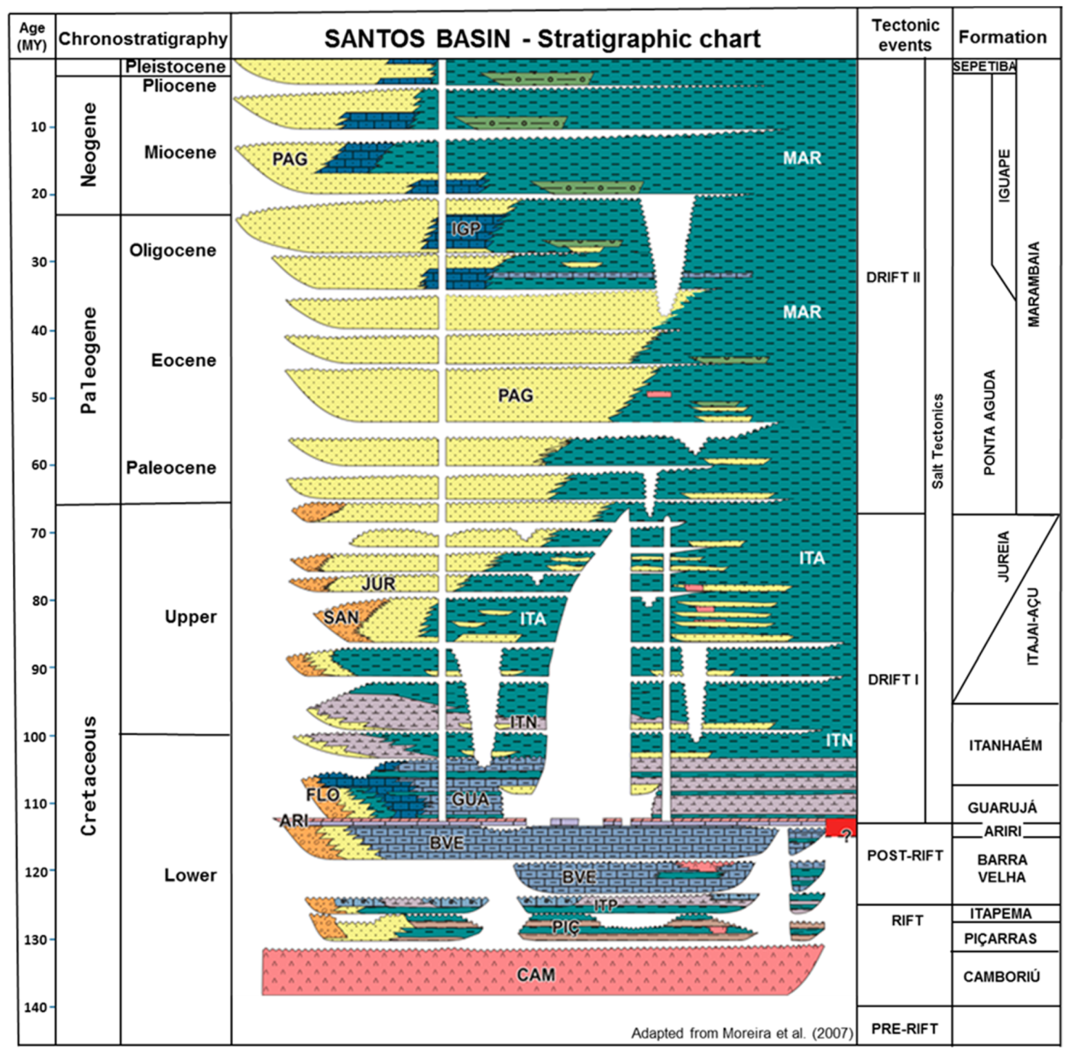
13] proposed the latest stratigraphic chart for Santos Basin (
Figure 2).
During the process of separation of the African and South American plates, at the beginning of the rift phase, basaltic flows of the Camboriú Formation (Hauterivian) occurred, which is associated with the early stretching of the crust. Above the basalts, conglomerates and polimythic sandstones of the Piçarras Formation were deposited in proximal areas and organic-rich black shales in deeper parts of the basin, during a period of intense tectonic activity. Above the Piçarras Formation, still in the rift phase but in a less intense tectonic period, bounded by two prominent unconformities, the Itapema Formation was deposited with a great variety of limestones in proximal domains and layers of black shales in distal areas. In some areas, coquina reservoirs of great permo-porosity quality occur in this formation. Covering the Itapema Formation, the Barra Velha Formation occurs as a sequence of limestones, stromatolites, microbiolites, and shales deposited in a hypersaline shallow marine environment. Immediately above these reservoirs a 2000 m thick evaporitic sequence—the Ariri Formation—is a perfect seal. Above this evaporitic section several depositional sequences, mainly composed of open marine siliciclastics, mostly sandstones near shore and shales in greater depths, fill the basin since Albian to Quaternary.
The basin spans some 300 km along the continent and 700 km width in its dip direction. These dimensions indicate the unusual stretching suffered by the continental crust during the early stages of this basin formation [
14]. The equivalent section at the conjugated margin, at the African side, is significantly narrower highlighting the asymmetry of the two continental passive margins.
This basin started to be explored for hydrocarbons in the early seventies and its first discovery, the Merluza field, was announced in 1979. More recently, after 2006, giant oil fields were discovered in its deep-water region, and Santos Basin became the most prolific basin of Brazil. However, in some of these significant hydrocarbon discoveries. abnormal amounts of CO2 were identified. Due to the production problems created by these high CO2 contents avoidance of such areas is desirable, and this can only be achieved by an understanding of the origin, migration paths, and trapping of this CO2.
3.2. Structural Elements of Santos Basin-São Paulo Plateau
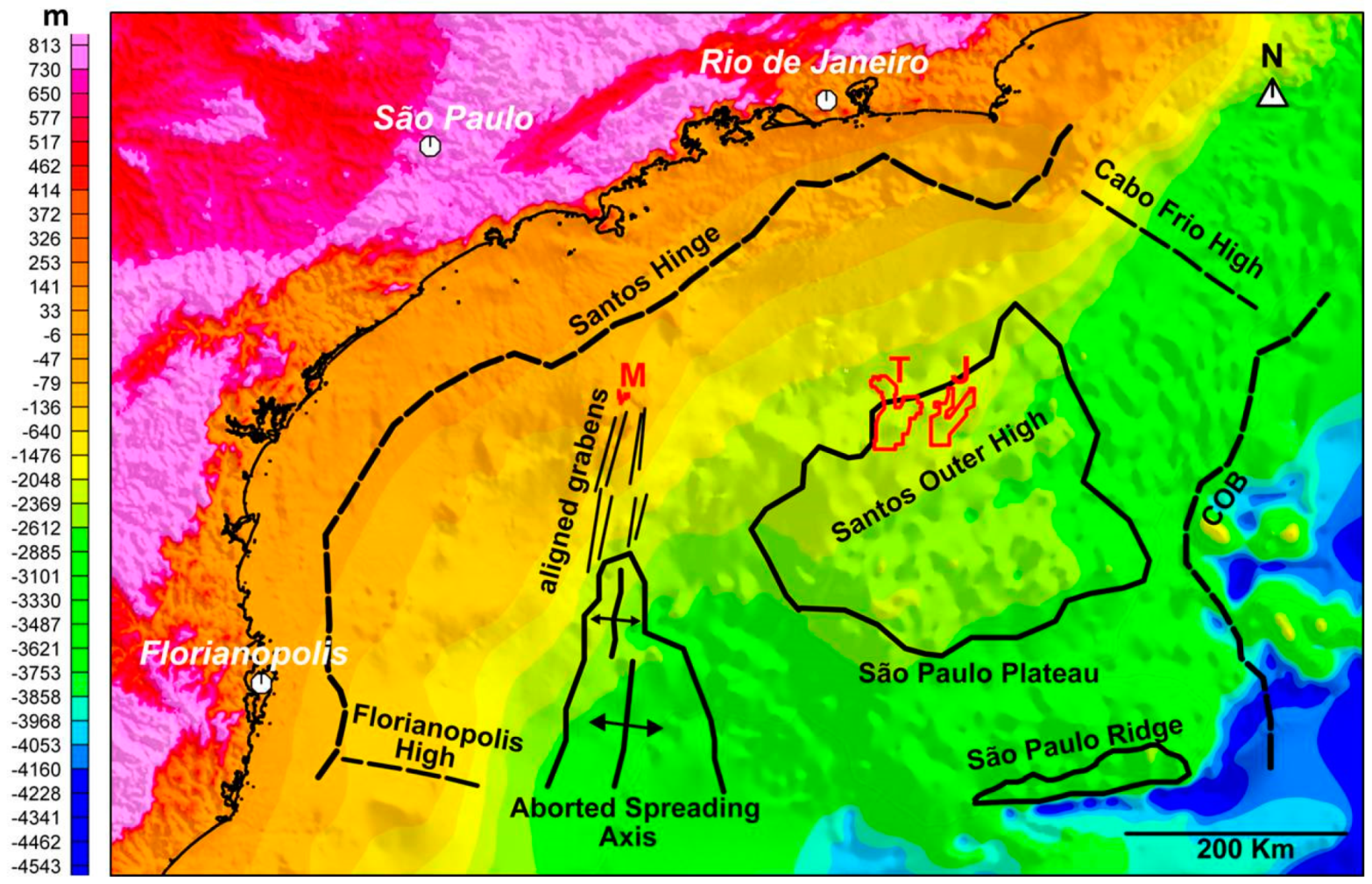
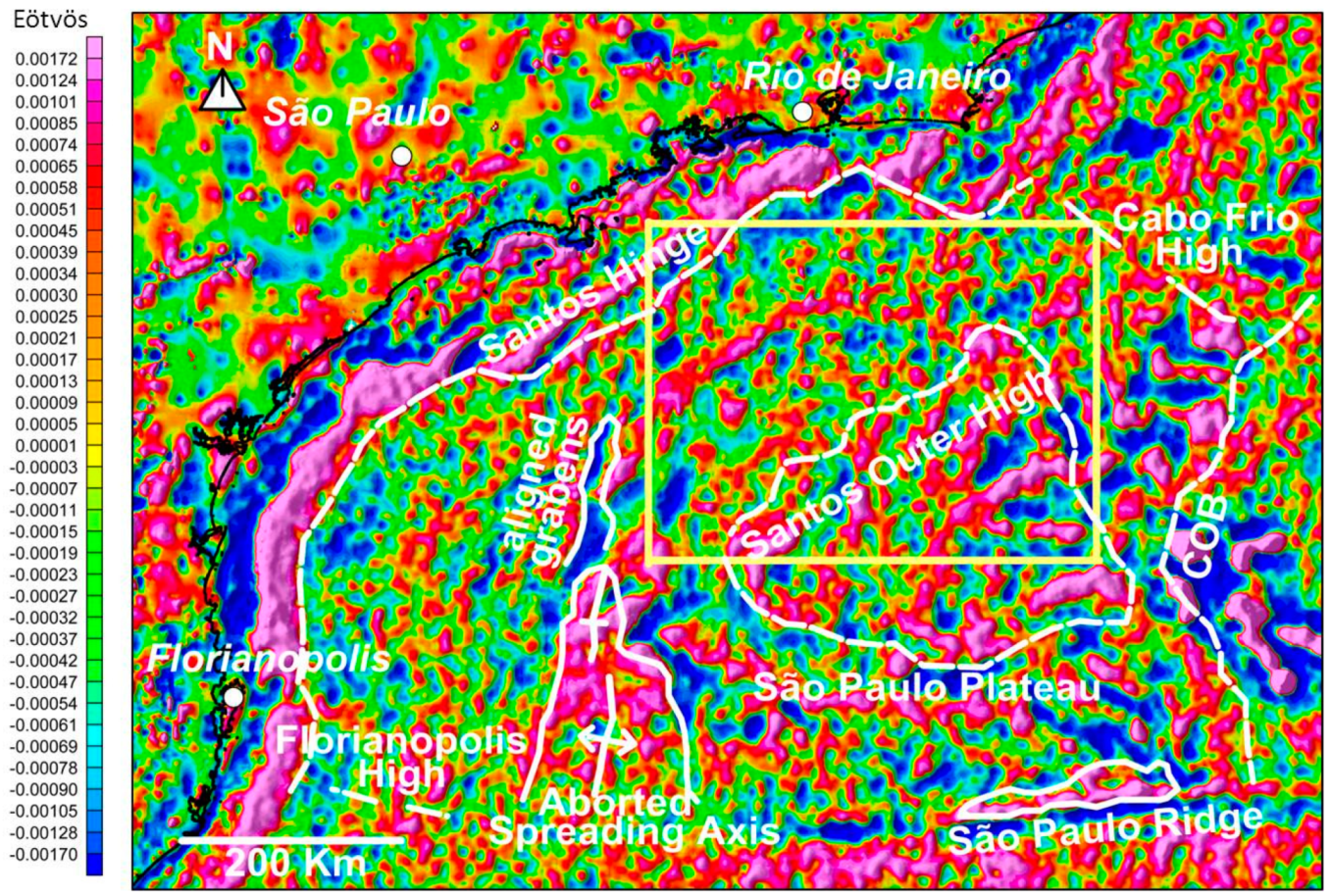
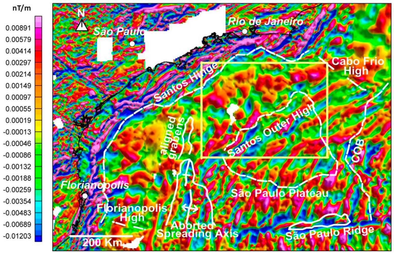
The main structural elements defined by the seismic data in this area can be highlighted and better defined using gravimetric and magnetic methods (
Figure 3 and
Figure 4). A residual Bouguer anomaly map obtained by the removal of the regional trend, typically ascending towards the oceanic crust from its first vertical derivative or vertical gradient, reflects the basement structure of the basin and the intra crustal structures normally associated with mantle elevations (
Figure 4). The western boundary of Santos Basin is defined by a hinge line highlighted by a prominent gravity positive anomaly.
Another conspicuous positive anomaly of great magnitude is observed at the southwestern limit of the basin. This anomaly is associated with a mantle elevation and formation of oceanic crust in this region.
In map view, it has an arrow shape that narrows to the north (
Figure 3 and
Figure 4). It extends northwards up to the region of the Merluza Field as a negative aligned anomaly. This arrow-shaped feature is interpreted as an early aborted spreading center related to an initial rifting process. A graben affecting the basement rocks is visible there on seismic data. No oceanic crust is interpreted within this northern graben. The oceanic crust was formed at its wider southern part whereas just a continental graben occurs further to the north (
Figure 3 and
Figure 4).
A conspicuous large amplitude residual anomaly pattern delineates the Santos Outer High and further east the continent–ocean boundary (COB) is interpreted (
Figure 4). The southern boundary of the São Paulo Plateau is clearly defined by a positive anomaly and by a prominent topographic feature named São Paulo Ridge, which is part of a major fracture zone—the Florianópolis Fracture Zone (
Figure 4). The yellow rectangle in this figure defines the area where CO
2 anomalies were found in hydrocarbon reservoirs.
A good correlation is observed between the residual Bouguer map and the vertical gradient map of the total magnetic field (
Figure 4 and
Figure 5). The hinge line of the basin is marked by a clear contrast between a high-frequency anomaly pattern, indicative of shallow basement and a smooth pattern of the deeper basement to the east.
The Santos Basin Outer High identified on the gravimetric records (
Figure 4) cannot be defined on the magnetic map (
Figure 5). This is due to the predominance of intracrustal magnetic bodies as the source for such anomalies. Such source obliterates any contribution from the basement surface as a source of anomalies. Whereas in the gravimetric record is the opposite, the highs and lows related to the structure of the basement are responsible for the majority of the gravimetric contributions.
The abundant presence of such intracrustal sources generates a typical magnetic pattern that characterizes the crust under the São Paulo Plateau. The boundaries of this crustal domain are defined by a relative increase in the frequency content generated by linear anomalies controlled by the NE-SW structural trend of the basement rocks (
Figure 5).
The distribution of these anomalies is similar to the one observed on a typical oceanic crust. The crust under the São Paulo Plateau can be interpreted as a highly stretched and magmatic injected continental crust or a transitional crust [
15,
16]. The western limit of this province is defined by the aborted spreading center axis, followed to the north by aligned grabens and by the NW boundary of Santos Outer High. On the other side, the eastern limit is the boundary between the continental and the oceanic crust (
Figure 4 and
Figure 5).
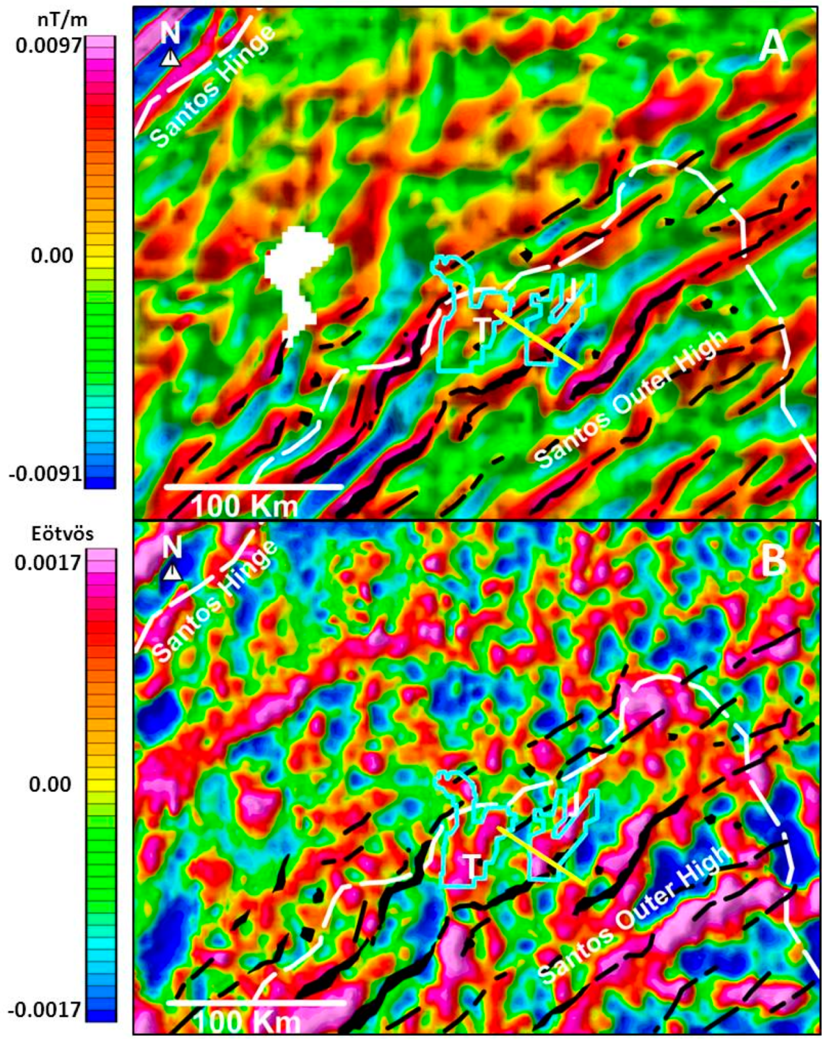
Figure 6 shows the detailed studied area (yellow rectangle in
Figure 4 and
Figure 5) where magmatic bodies injected into the crust were interpreted from the horizontal derivative in the direction of the magnetization induced by the current magnetic field. Additionally, a vertical derivative calculated from the horizontal one produced a view with more details and a better positioning of the interpreted magmatic bodies associated to the axes of maximum values of the derivative (
Figure 6A).
The methodology for mapping the magmatic bodies was developed in this research based on the analysis of the derivative maps with the orientation of the modeled section of
Figure 7. This kind of approach seems to be more effective than the most commonly used methodology in which the vertical derivative of the field reduced to the pole is determined. This is due to the characteristic positioning of the magmatic bodies, strongly aligned in the NE-SW direction of the rift structural trend (normal to the magnetic field) which greatly intensifies the induced magnetization component, thus favoring the horizontal derivative in the direction of the current magnetic field.
Figure 6B shows the residual Bouguer anomaly in relation to the underlying magmatic bodies. Positive residual anomalies (areas in red and pink) reflect the basement structural highs, bordered by normal faults that were active during the rifting stages of the basin.
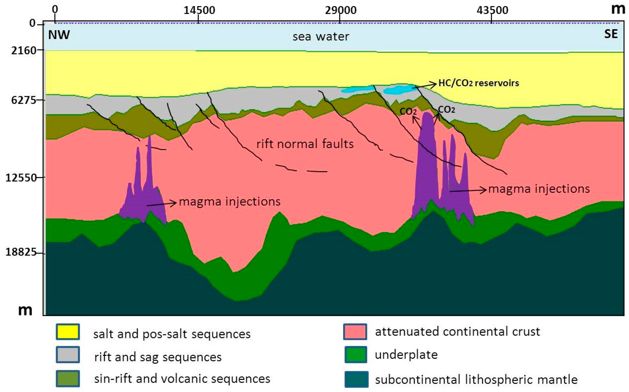
The modeled section (
Figure 7), perpendicular to the main trend of the faults in the area was obtained by the direct method using a 2.5 D model in which, to avoid ambiguities, restrictions were imposed using the 3D seismic data information, such as the base of the evaporitic section and the volcanic basement. The deeper levels of the crust were not defined by seismic data but from the gravity and magnetic data instead.
The attenuated continental crust under the volcanic sequence considered as the basement for this basin was also defined. The thickness of this crust is highly variable due to the great amounts of stretching experienced by this region.
These areas of crustal thinning are more susceptive to suffer magmatic injections with mantle-derived materials. Vertical magmatic intrusions could reach the higher crustal levels where they could be intercepted by rifting faults propagating at the higher levels of the basement or later on in younger formed grabens as well.
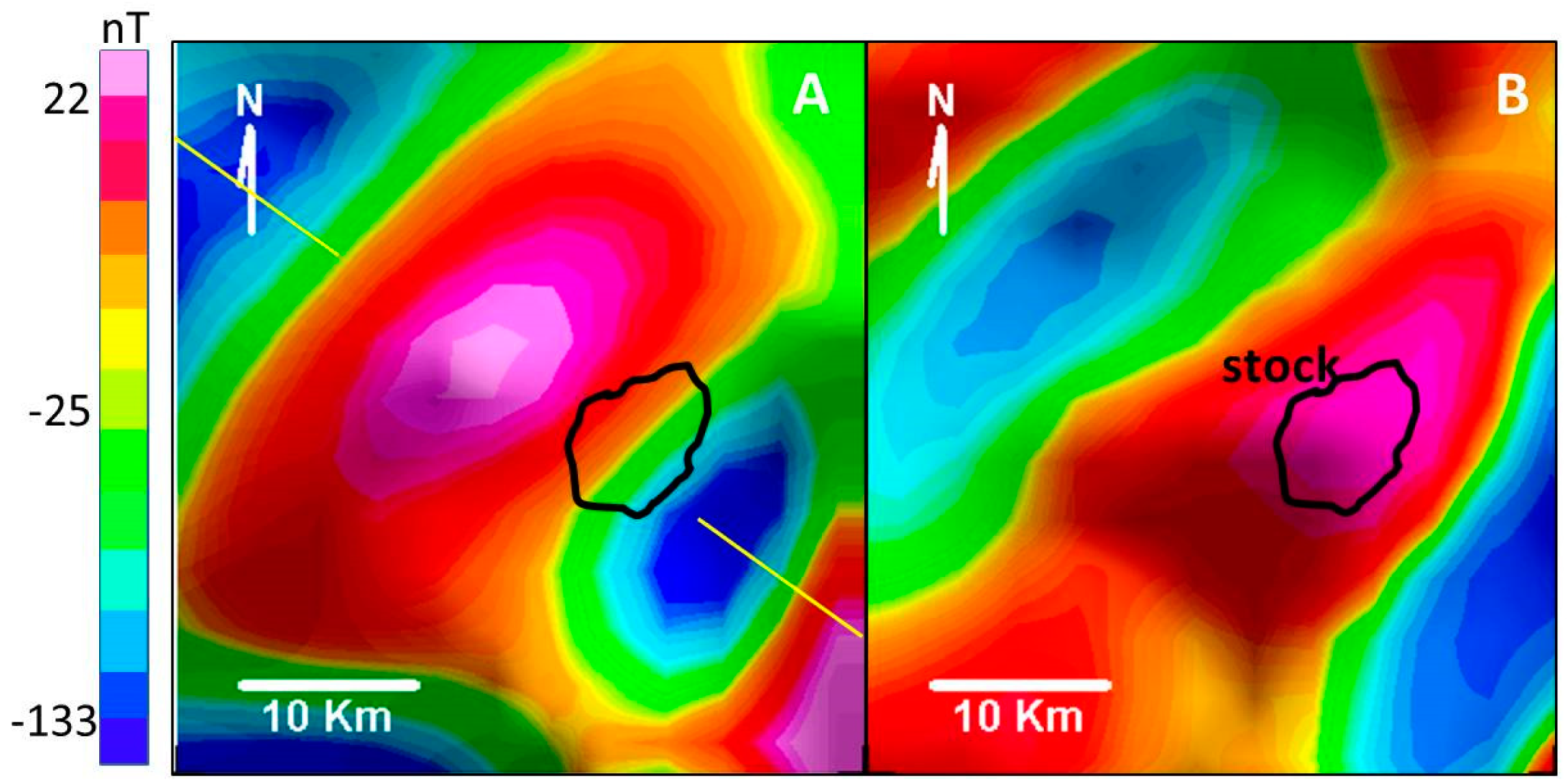
In the studied area, over the Jupiter structure, a strong total field magnetic anomaly is noticeable (
Figure 8A). This anomaly is interpreted as produced by a robust intrusive body that reaches the upper crust close to the base of the sedimentary layers of the syn-rift section (
Figure 7). This intrusive body is well evidenced by the transformation of the total magnetic field anomaly map by the methodology of the derivatives, developed in this research, described above (
Figure 8B). The estimated position of the top of the intrusive body is, thus, mapped with improved accuracy.
This is a typical anomaly of a localized body, associated to a probable large stock (
Figure 8B). In the studied region, there are other similar anomalies, but these are much less prominent than the Jupiter anomaly that reaches more than 150 nT of amplitude (
Figure 8A). The smaller anomalies verified in the area are probably associated with deeper or smaller intrusions and are therefore masked by regional total field anomalies and highlighted only by the gradients of the field (
Figure 5 and
Figure 6A).
Numerous magmatic bodies intruded in the crust were defined extrapolating this model for the detailed anomaly in conjunction with the regional magnetic gradient map (
Figure 6A). Plugs and stocks are shown on the map as black polygons and large dikes as black traces (
Figure 6). These magmatic intrusions seem to be more abundant towards the distal parts of the basin in areas of the Outer High region controlled by the NE-SW structural trend of the rift.
4. Discussion
The large concentrations CO
2 in Santos Basin were unexpected during the early exploratory process of its deep-water areas. However, drilled pre-salt prospects have shown a wide range of CO
2 contents bringing together environmental and production complications. The mantellic origin of these CO
2 occurrences was established via noble gases isotopic analyses [
4]. Nevertheless, processes and mechanisms responsible for the fate (introduction, migration, and preservation) of CO
2 in petroleum systems still remain unclear.
Many authors have suggested that the “CO
2-risk” in sedimentary basins could be related to the proximity of igneous intrusions and deep-seated faults, or to geothermal gradient higher than 30° C/km [
3,
5]. Other geoscientists suggested empirically that in some areas as, for example, in the Southeast Asia, CO
2 accumulations must be controlled by type and age of crustal basement, fault density, temperature, and pressure of reservoirs [
6].
More recently, strong evidence has been gathered indicating that mantle helium and occurrences with higher percentages of CO
2 were related to areas of crustal thinning in depths of about 26–28 km, with thermal flux higher than 61 mW/m
2 [
7].
Such conditions suggest rock melting due to the asthenosphere rising towards the crust. However, the occurrence of just one or more factors described above is not an unequivocal proxy for large accumulations of CO2 in petroleum reservoirs. Such uncertainties are the main reason to investigate more thoroughly processes and mechanisms that generate, introduce, and accumulate CO2 in petroleum systems. Independently of such myriad of details to be studied, a tool with the power to recognize deep related magmatic processes would be an excellent proxy to infer “CO2-risk” in petroleum reservoirs.
In this way, our work focused on crustal studies is based mainly on potential method data associated with the geologic interpretation of the Jupiter Prospect data, where the highest CO2 concentrations are reported up to date. The obtained results allow us to propose an association of the CO2 and intracrustal intrusions of mantle-derived material.
Both gravity and magnetic data indicate the existence of a highly stretched continental crust under the São Paulo Plateau and a rather unique and conspicuous anomaly under the Jupiter Prospect. Modeling indicates that this anomaly corresponds to an intracrustal intrusion that reached almost to the top of the basement rocks in this area. We interpret this intrusion as the main responsible agent to transport CO2 from the mantle into the reservoir levels in the pre-salt section of this area. Other occurrences of CO2 in Santos Basin are all located in the stretched crust of the basin and are also interpreted as provenient from mantle material ascending along major fault segments.
The São Paulo Plateau, the distal portion of Santos Basin went to a complex rifting from its African counterparts and suffered extreme crustal stretching. That created a unique type of crust, which can almost be considered as a transition between continental to oceanic crust. Characteristics of both can be seen on the potential methods data. Thinning of the continental crust on the São Paulo Plateau facilitated mantle-derived material to rise to the upper crustal levels, bringing together CO
2 that eventually could migrate to upper levels and become trapped in reservoirs, with or without hydrocarbons or other gases like H
2S. The conspicuous magnetic anomaly found under the Jupiter Prospect indicates a shallow intrusion reaching almost the base of the sedimentary sections. The heavy oil found in the Prospect Jupiter can be explained by the selective extraction of light molecular weight of petroleum fraction due to the natural chromatographic effect produced by the CO
2 migration in a process similar to the one proposed by [
17].
Very low CO2 content is found in the petroleum fields located at the proximal areas of Santos Basin, neither on the fields of Recôncavo or Potiguar aborted rifts. In basins with expressive volcanism, like the Solimões Basin, where a thick continental crust exists, or even in Campos Basin, located to the north of Santos and with a much lesser amount of crustal stretching, almost no CO2 is found. The lack of CO2 in areas of lesser amounts of continental crustal stretching seems to be a rule.
Analyses of satellite potential data seem to work very well to characterize basins located on stretched continental where potentially mantle-derived material could rise to the upper crustal levels and bring large amounts of CO2 with them. In this work, we have demonstrated the immense potential contained in these data. Potential data from regional satellite grid should thus be considered as an exploratory tool of great value to estimate “CO2-risk”.
5. Conclusions
Gravimetric and magnetic methods are reliable proxies for the identification of major intrusive bodies, crustal thinning, and other geotectonic elements that are related to the significant occurrences of CO2 in the Southern offshore Brazilian basins, e.g., Santos and Campos.
Considering the unequivocal relationship between the abundance of CO
2 and the intensity of mantle signature of CO
2-associated helium [
4], the approach used in this work can be an efficient tool to predict the “CO
2-risk” in those basins.
Despite the significant progress that has already been reached on the understanding of CO2 fate, the role of other variables that could control the abundances of CO2 in reservoirs is still unclear, sometimes twin prospects have significant differences in the percentages of such gas.
