UAV and Airborne LiDAR Data for Interpreting Kinematic Evolution of Landslide Movements: The Case Study of the Montescaglioso Landslide (Southern Italy)
Abstract
1. Introduction
2. The Montescaglioso Landslide
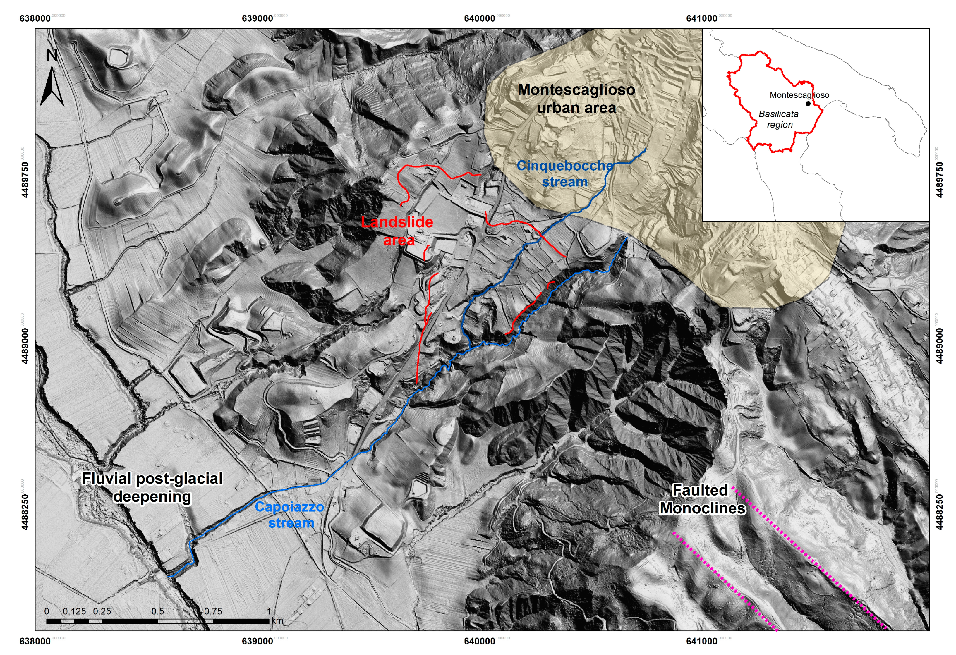
2.1. Landslide Setting
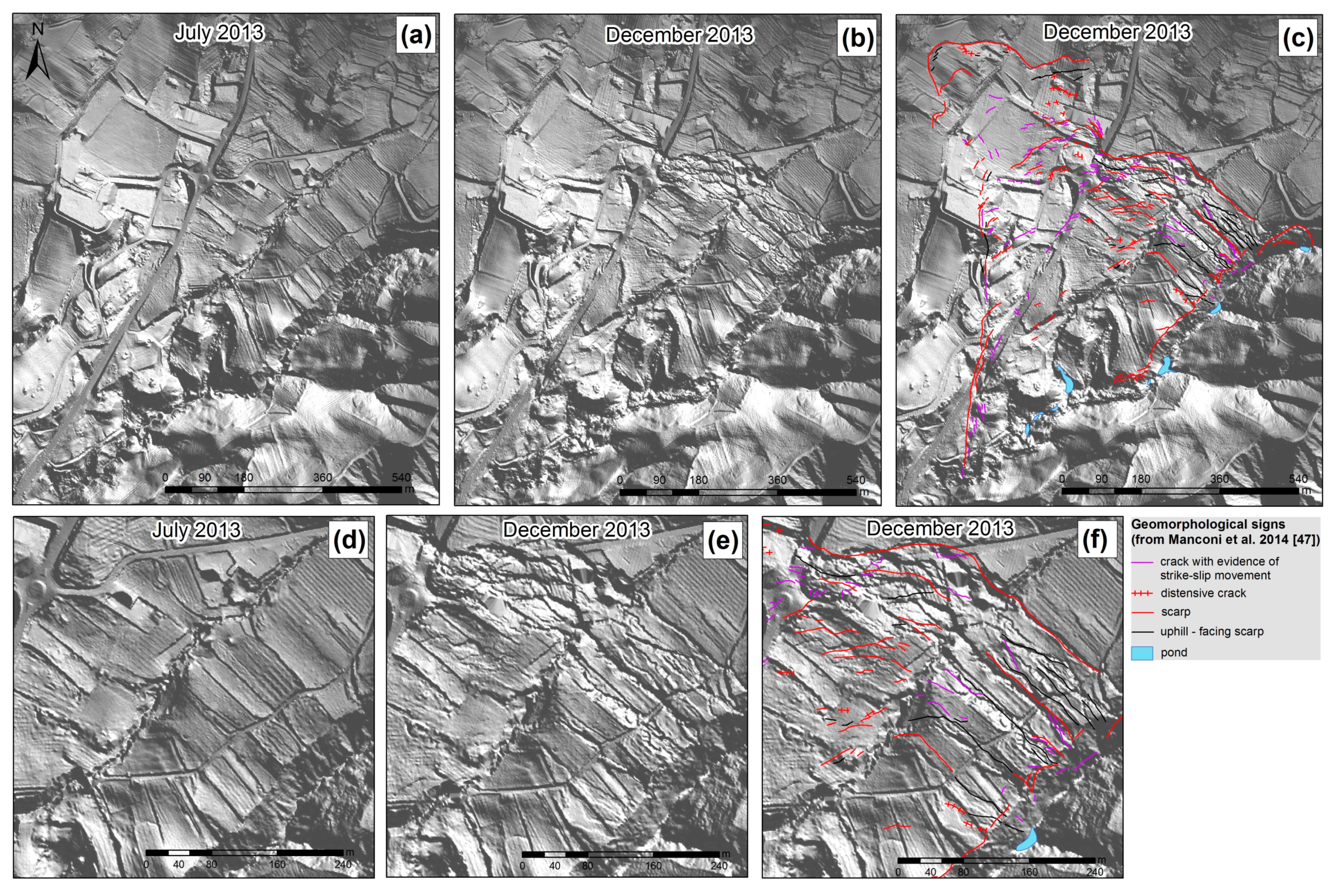
2.2. Landslide Field Surveys and Monitoring
3. Data Collection and Methodology
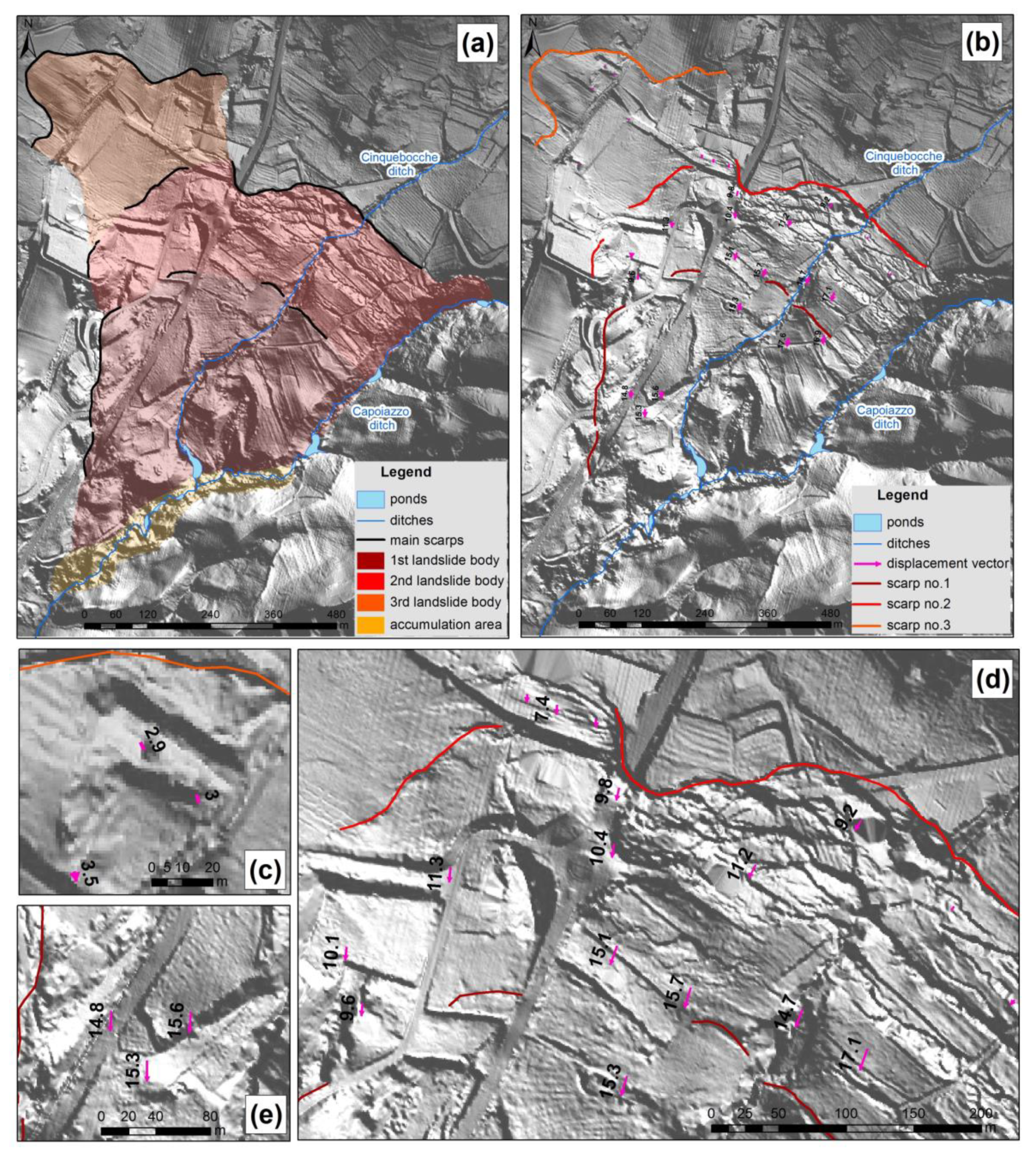
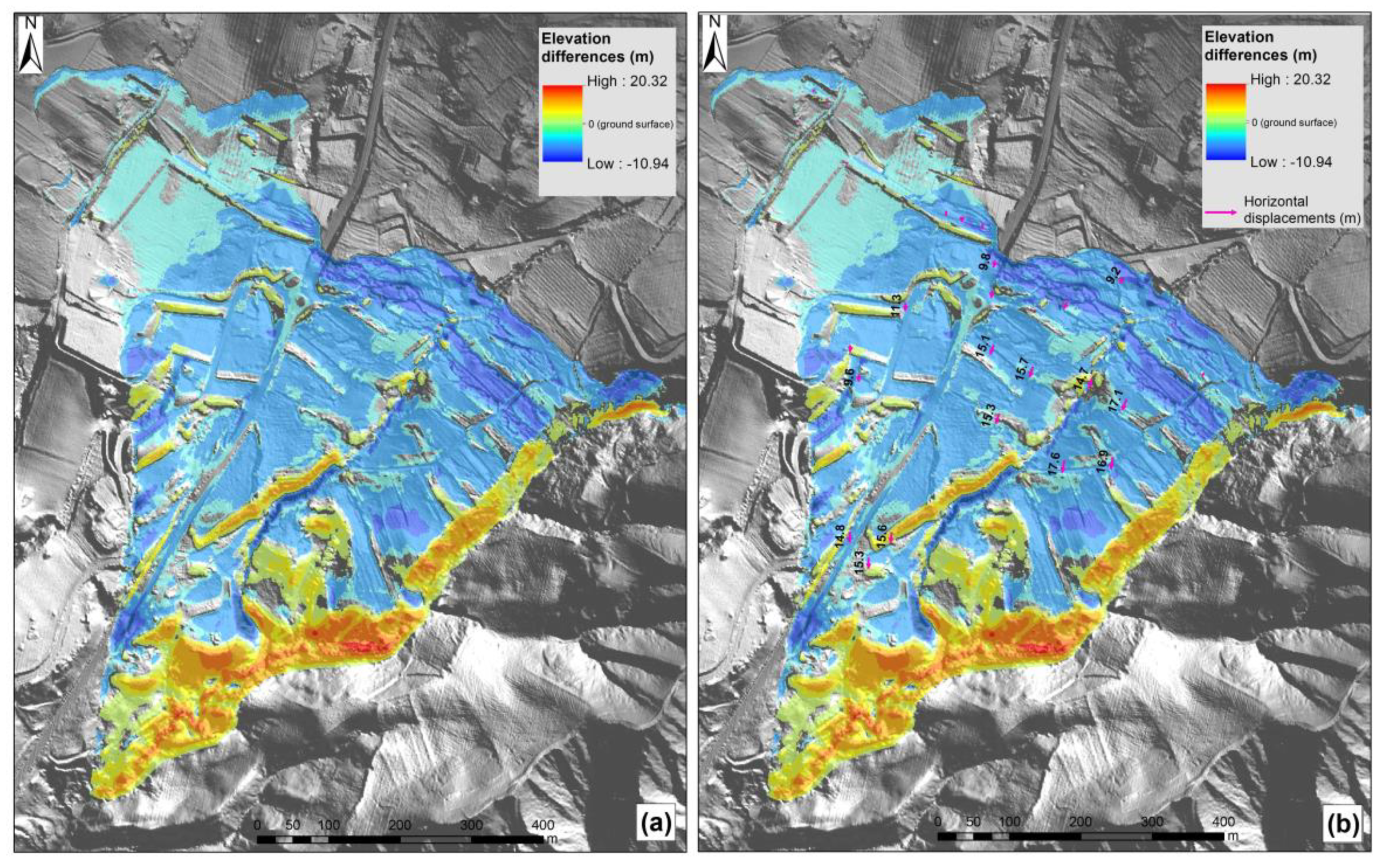
4. Landslide Kinematic Interpretation: Results and Discussion
5. Conclusions
Author Contributions
Acknowledgments
Conflicts of Interest
References
- Corsini, A.; Borgatti, L.; Coren, F.; Vellico, M. Use of multitemporal airborne LiDAR surveys to analyse post-failure behaviour of earth slides. Can. J. Remote Sens. 2007, 33, 116–120. [Google Scholar] [CrossRef]
- Lollino, G.; Manconi, A.; Giordan, D.; Allasia, P.; Baldo, M. Infrastructure in geohazard contexts: The importance of automatic and near-real-time monitoring. In Environmental Security of the European Cross-Border Energy Supply Infrastructure; Springer: Dordrecht, The Netherlands, 2015; pp. 73–89. ISBN 9789401795388. [Google Scholar]
- Casagli, N.; Frodella, W.; Morelli, S.; Tofani, V.; Ciampalini, A.; Intrieri, E.; Raspini, F.; Rossi, G.; Tanteri, L.; Lu, P. Spaceborne, UAV and ground-based remote sensing techniques for landslide mapping, monitoring and early warning. Geoenviron. Disasters 2017, 4, 9. [Google Scholar] [CrossRef]
- Spilotro, G.; Pellicani, R.; Canora, F.; Allasia, P.; Giordan, D.; Lollino, G. Evolution of techniques for monitoring unstable slopes. Ital. J. Eng. Geol. Environ. 2017, 17, 5–17. [Google Scholar] [CrossRef]
- Manfreda, S.; McCabe, M.; Miller, P.; Lucas, R.; Pajuelo Madrigal, V.; Mallinis, G.; Ben Dor, E.; Helman, D.; Estes, L.; Ciraolo, G.; et al. On the use of unmanned aerial systems for environmental monitoring. Remote Sens. 2018, 10, 641. [Google Scholar] [CrossRef]
- Toschi, I.; Allocca, M.; Remondino, F. Geomatics mapping of natural hazards: Overview and experiences. Int. Arch. Photogramm. Remote Sens. Spat. Inf. Sci. 2018, XLII-3/W4, 505–512. [Google Scholar] [CrossRef]
- Kakooei, M.; Baleghi, Y. Fusion of satellite, aircraft, and UAV data for automatic disaster damage assessment. Int. J. Remote Sens. 2017, 38, 2511–2534. [Google Scholar] [CrossRef]
- He, Y.; Song, Z.; Liu, Z. Updating highway asset inventory using airborne LiDAR. Meas. J. Int. Meas. Confed. 2017, 104, 132–141. [Google Scholar] [CrossRef]
- Neugirg, F.; Stark, M.; Kaiser, A.; Vlacilova, M.; Della Seta, M.; Vergari, F.; Schmidt, J.; Becht, M.; Haas, F. Erosion processes in calanchi in the Upper Orcia Valley, Southern Tuscany, Italy based on multitemporal high-resolution terrestrial LiDAR and UAV surveys. Geomorphology 2016, 269, 8–22. [Google Scholar] [CrossRef]
- Cawood, A.J.; Bond, C.E.; Howell, J.A.; Butler, R.W.H.; Totake, Y. LiDAR, UAV or compass-clinometer? Accuracy, coverage and the effects on structural models. J. Struct. Geol. 2017, 98, 67–82. [Google Scholar] [CrossRef]
- Cook, K.L. An evaluation of the effectiveness of low-cost UAVs and structure from motion for geomorphic change detection. Geomorphology 2017, 278, 195–208. [Google Scholar] [CrossRef]
- Silva, O.L.; Bezerra, F.H.R.; Maia, R.P.; Cazarin, C.L. Karst landforms revealed at various scales using LiDAR and UAV in semi-arid Brazil: Consideration on karstification processes and methodological constraints. Geomorphology 2017, 295, 611–630. [Google Scholar] [CrossRef]
- Elsner, P.; Dornbusch, U.; Thomas, I.; Amos, D.; Bovington, J.; Horn, D. Coincident beach surveys using UAS, vehicle mounted and airborne laser scanner: Point cloud inter-comparison and effects of surface type heterogeneity on elevation accuracies. Remote Sens. Environ. 2018, 208, 15–26. [Google Scholar] [CrossRef]
- Khan, S.; Aragão, L.; Iriarte, J. A UAV–LiDAR system to map Amazonian rainforest and its ancient landscape transformations. Int. J. Remote Sens. 2017, 38, 2313–2330. [Google Scholar] [CrossRef]
- Johnson, K.M.; Ouimet, W.B. An observational and theoretical framework for interpreting the landscape palimpsest through airborne LiDAR. Appl. Geogr. 2018, 91, 32–44. [Google Scholar] [CrossRef]
- Masini, N.; Marzo, C.; Manzari, P.; Belmonte, A.; Sabia, C.; Lasaponara, R. On the characterization of temporal and spatial patterns of archaeological crop-marks. J. Cult. Herit. 2018. [Google Scholar] [CrossRef]
- Sankey, T.T.; McVay, J.; Swetnam, T.L.; McClaran, M.P.; Heilman, P.; Nichols, M. UAV hyperspectral and LiDAR data and their fusion for arid and semi-arid land vegetation monitoring. Remote Sens. Ecol. Conserv. 2017. [Google Scholar] [CrossRef]
- Nie, S.; Wang, C.; Xi, X.; Luo, S.; Li, S.; Tian, J. Estimating the height of wetland vegetation using airborne discrete-return LiDAR data. Optik (Stuttg.) 2018, 154, 267–274. [Google Scholar] [CrossRef]
- Aicardi, I.; Chiabrando, F.; Lingua, A.M.; Noardo, F.; Piras, M.; Vigna, B. A methodology for acquisition and processing of thermal data acquired by UAVs: A test about subfluvial springs’ investigations. Geomat. Nat. Hazards Risk 2017, 8, 5–17. [Google Scholar] [CrossRef]
- Pagliari, D.; Rossi, L.; Passoni, D.; Pinto, L.; De Michele, C.; Avanzi, F. Measuring the volume of flushed sediments in a reservoir using multi-temporal images acquired with UAS. Geomat. Nat. Hazards Risk 2017, 8, 150–166. [Google Scholar] [CrossRef]
- Civico, R.; Pucci, S.; De Martini, P.M.; Pantosti, D. Morphotectonic analysis of the long-term surface expression of the 2009 L’Aquila earthquake fault (Central Italy) using airborne LiDAR data. Tectonophysics 2015, 644, 108–121. [Google Scholar] [CrossRef]
- Nissen, E.; Maruyama, T.; Ramon Arrowsmith, J.; Elliott, J.R.; Krishnan, A.K.; Oskin, M.E.; Saripalli, S. Coseismic fault zone deformation revealed with differential LiDAR: Examples from Japanese Mw ~7 intraplate earthquakes. Earth Planet. Sci. Lett. 2014, 405, 244–256. [Google Scholar] [CrossRef]
- Valkaniotis, S.; Papathanassiou, G.; Ganas, A. Mapping an earthquake-induced landslide based on UAV imagery; case study of the 2015 Okeanos landslide, Lefkada, Greece. Eng. Geol. 2018, 245, 141–152. [Google Scholar] [CrossRef]
- Bonali, F.L.; Tibaldi, A.; Marchese, F.; Fallati, L.; Russo, E.; Corselli, C.; Savini, A. UAV-based surveying in volcano-tectonics: An example from the Iceland rift. J. Struct. Geol. 2019, 121, 46–64. [Google Scholar] [CrossRef]
- De Beni, E.; Cantarero, M.; Messina, A. UAVs for volcano monitoring: A new approach applied on an active lava flow on Mt. Etna (Italy), during the 27 February–02 March 2017 eruption. J. Volcanol. Geotherm. Res. 2019, 369, 250–262. [Google Scholar] [CrossRef]
- Zhou, Z.; Gong, J.; Hu, X. Community-scale multi-level post-hurricane damage assessment of residential buildings using multi-temporal airborne LiDAR data. Autom. Constr. 2019, 98, 30–45. [Google Scholar] [CrossRef]
- Silva, L.D.O.; de Bandeira, R.A.M.; Campos, V.B.G. Proposal to planning facility location using UAV and geographic information systems in a post-disaster scenario. Int. J. Disaster Risk Reduct. 2019, 27, 101080. [Google Scholar] [CrossRef]
- Giordan, D.; Manconi, A.; Remondino, F.; Nex, F. Use of unmanned aerial vehicles in monitoring application and management of natural hazards. Geomat. Nat. Hazards Risk 2017, 8, 1–4. [Google Scholar] [CrossRef]
- Ventura, G.; Vilardo, G.; Terranova, C.; Sessa, E.B. Tracking and evolution of complex active landslides by multi-temporal airborne LiDAR data: The Montaguto landslide (Southern Italy). Remote Sens. Environ. 2011, 115, 3237–3248. [Google Scholar] [CrossRef]
- Fiorucci, F.; Giordan, D.; Santangelo, M.; Dutto, F.; Rossi, M.; Guzzetti, F. Criteria for the optimal selection of remote sensing optical images to map event landslides. Nat. Hazards Earth Syst. Sci. 2018, 18, 405–417. [Google Scholar] [CrossRef]
- Mora, O.E.; Liu, J.; Lenzano, M.G.; Toth, C.K.; Grejner-Brzezinska, D. Small Landslide Susceptibility and Hazard Assessment Based on Airborne LiDAR Data. Photogramm. Eng. Remote Sens. 2015, 81, 239–247. [Google Scholar] [CrossRef]
- Giordan, D.; Allasia, P.; Manconi, A.; Baldo, M.; Santangelo, M.; Cardinali, M.; Corazza, A.; Albanese, V.; Lollino, G.; Guzzetti, F. Morphological and kinematic evolution of a large earthflow: The Montaguto landslide, southern Italy. Geomorphology 2013, 187, 61–79. [Google Scholar] [CrossRef]
- Rothmund, S.; Vouillamoz, N.; Joswig, M. Mapping slow-moving alpine landslides by UAV—Opportunities and limitations. Lead. Edge 2017, 36, 571–579. [Google Scholar] [CrossRef]
- Harwin, S.; Lucieer, A. Assessing the Accuracy of Georeferenced Point Clouds Produced via Multi-View Stereopsis from Unmanned Aerial Vehicle (UAV) Imagery. Remote Sens. 2012, 4, 1573–1599. [Google Scholar] [CrossRef]
- Westoby, M.; Brasington, J.; Glasser, N.F.; Hambrey, M.J.; Reyonds, M.J. Structure-from Motion photogrammetry: A low-cost, effective tool for geoscience applications. Geomorphology 2012, 179, 300–314. [Google Scholar] [CrossRef]
- Furukawa, Y.; Ponce, J. Accurate, dense, and robust multiview stereopsis. IEEE Trans. Pattern Anal. Mach. Intell. 2010, 32, 1362–1376. [Google Scholar] [CrossRef] [PubMed]
- James, M.R.; Robson, S. Straightforward reconstruction of 3d surfaces and topography with a camera:Accuracy and geoscience application. J. Geophys. Res. Earth Surf. 2012, 117, F03017. [Google Scholar] [CrossRef]
- Eltner, A.; Kaiser, A.; Castillo, C.; Rock, G.; Neugirg, F.; Abellán, A. Image-based surface reconstruction ingeomorphometry—Merits, limits and developments. Earth Surf. Dyn. 2016, 4, 359–389. [Google Scholar] [CrossRef]
- Lucieer, A.; Jong, S.M.D.; Turner, D. Mapping landslide displacements using Structure from Motion (SfM) and image correlation of multi-temporal UAV photography. Prog. Phys. Geogr. 2014, 38, 97–116. [Google Scholar] [CrossRef]
- Clapuyt, F.; Vanacker, V.; Van Oost, K.; Schlunegger, F. Very-high resolution monitoring of movement of surface material within a landslide. In Geomorphometry; Naukowe, B.W., Mickiewicz, A., Eds.; University in Poznań—Institute of Geoecology and Geoinformation: Poznań, Poland, 2015; ISBN 978-83-7986-059-3. [Google Scholar]
- Giordan, D.; Manconi, A.; Allasia, P.; Bertolo, D. Brief Communication: On the rapid and efficient monitoring results dissemination in landslide emergency scenarios: The Mont de la Saxe case study. Nat. Hazards Earth Syst. Sci. 2015, 15, 2009–2017. [Google Scholar] [CrossRef]
- Giordan, D.; Manconi, A.; Tannant, D.D.; Allasia, P. UAV: Low-cost remote sensing for high-resolution investigation of landslides. In Proceedings of the 2015 IEEE International Geoscience and Remote Sensing Symposium (IGARSS), Milan, Italy, 26–31 July 2015; pp. 5344–5347. [Google Scholar]
- Peppa, M.V.; Mills, J.P.; Moore, P.; Miller, P.E.; Chambers, J.E. Accuracy assessment of a uav-based landslide monitoring system. Int. Arch. Photogramm. Remote Sens. Spat. Inf. Sci. ISPRS Arch. 2016, 41, 895–902. [Google Scholar] [CrossRef]
- D’ecclesiis, G.; Lorenzo, P. Frane relitte nei depositi della fossa bradanica: La frana di Madonna della Nuova (Montescaglioso, Basilicata). Giornale di Geologia Applicata 2006, 4, 257–262. (In Italian) [Google Scholar] [CrossRef]
- Bozzano, F.; Caporossi, P.; Esposito, C.; Martino, S.; Mazzanti, P.; Moretto, S.; Mugnozza, G.S.; Rizzo, A.M. Mechanism of the Montescaglioso Landslide (Southern Italy) Inferred by Geological Survey and Remote Sensing. In Advancing Culture of Living with Landslides; Mikos, M., Tiwari, B., Yin, Y., Sassa, K., Eds.; Springer International Publishing: Cham, Switzerland, 2017; Volume 2, pp. 97–106. ISBN 978-3-319-53498-5. [Google Scholar]
- Manconi, A.; Casu, F.; Ardizzone, F.; Bonano, M.; Cardinali, M.; De Luca, C.; Gueguen, E.; Marchesini, I.; Parise, M.; Vennari, C.; et al. Brief Communication: Rapid mapping of landslide events: The 3 December 2013 Montescaglioso landslide, Italy. Nat. Hazards Earth Syst. Sci. 2014, 14, 1835–1841. [Google Scholar] [CrossRef]
- Manconi, A.; Casu, F.; Ardizzone, F.; Bonano, M.; Cardinali, M.; De Luca, C.; Gueguen, E.; Marchesini, I.; Parise, M.; Vennari, C.; et al. Supplement of Brief Communication: Rapid mapping of landslide events: The 3 December 2013 Montescaglioso landslide, Italy. Hazards Earth Syst. Sci. 2014, 14, 1835–1841. [Google Scholar] [CrossRef]
- Amanti, M.; Chiessi, V.; Guarino, P.M.; Spizzichino, D.; Troccoli, A.; Vizzini, G. Relazione finale di cui all’art. 5 (b) della Convenzione Operativa tra il Commissario Delegato, O.C.D.P.C. n. 151 del 21.2.2014 e l’Istituto Superiore per la Protezione e la Ricerca Ambientale (ISPRA) per monitoraggio e studi sulla frana di Montescaglioso (MT) del 3 dicembre 2013; ISPRA—Istituto Superiore per la Protezione e la Ricerca Ambientale: Rome, Italy, 2014. (In Italian) [Google Scholar]
- Allasia, P.; Lollino, P.; Limoni, P.P. Relazione finale relativa alle attività dell’Istituto di Ricerca per la Protezione Idrogeologica (IRPI) per monitoraggio e studi sulla frana di Montescaglioso (MT) del 3 Dicembre 2013; CNR—IRPI: Turin, Italy, 2017; p. 23. (In Italian) [Google Scholar]
- Lollino, P.; Parise, M.; Limoni, P.P. Bollettino delle misure inclinometriche eseguite sulla frana di Montescaglioso; CNR Istituto di Ricerca per la Protezione Idrogeologica: Torino, Italy, 2014. (In Italian) [Google Scholar]
- Raspini, F.; Ciampalini, A.; Del Conte, S.; Lombardi, L.; Nocentini, M.; Gigli, G.; Ferretti, A.; Casagli, N. Exploitation of Amplitude and Phase of Satellite SAR Images for Landslide Mapping: The Case of Montescaglioso (South Italy). Remote Sens. 2015, 7, 14576–14596. [Google Scholar] [CrossRef]
- Pellicani, R.; Spilotro, G.; Ermini, R.; Sdao, F. The large montescaglioso landslide of December 2013 after prolonged and severe seasonal climate conditions. In Landslides and Engineered Slopes. Experience, Theory and Practice; Aversa, S., Cascini, L., Picarelli, L., Scavia, C., Eds.; CRC Press: Boca Raton, FL, USA, 2016; Volume 3, pp. 1591–1597. ISBN 9781498788076. [Google Scholar]
- Spilotro, G.; Sdao, F.; Ermini, R.; Pellicani, R.; Ataoui, R. Rapporto finale sull’attività tecnico—Scientifica di studio del movimento franoso del 3.12.2013 in Montescaglioso e validazione schede di progetti di messa in sicurezza; Università della Basilicata: Matera, Italy, 2014; 39p. (In Italian) [Google Scholar]
- Caporossi, P.; Mazzanti, P.; Bozzano, F.; Caporossi, P.; Mazzanti, P.; Bozzano, F. Digital Image Correlation (DIC) Analysis of the 3 December 2013 Montescaglioso Landslide (Basilicata, Southern Italy): Results from a Multi-Dataset Investigation. ISPRS Int. J. Geo-Inf. 2018, 7, 372. [Google Scholar] [CrossRef]
- Lazzari, M.; Piccarreta, M. Landslide Disasters Triggered by Extreme Rainfall Events: The Case of Montescaglioso (Basilicata, Southern Italy). Geosciences 2018, 8, 377. [Google Scholar] [CrossRef]
- RSDI—Geoportale Basilicata. Available online: http://rsdi.regione.basilicata.it/ (accessed on 13 June 2018).
- Nex, F.; Remondino, F. UAV for 3D mapping applications: A review. Appl. Geomat. 2014, 6, 1–15. [Google Scholar] [CrossRef]
- Cilloccu, F.; Dequal, S.; Brovelli, M.A.; Crespi, M.; Lingua, A. Ortoimmagini 1:1000 e modelli altimetrici—Linee guida; CISIS: Ottawa, ON, Canada, 2009; ISBN 9788885386976. [Google Scholar]
- Crosta, G.B.; Lollino, G.; Paolo, F.; Giordan, D.; Andrea, T.; Carlo, R.; Davide, B. Rockslide Monitoring Through Multi-temporal LiDAR DEM and TLS Data Analysis. In Engineering Geology for Society and Territory; Lollino, G., Giordan, D., Crosta, G.B., Corominas, J., Azzam, R., Wasowski, J., Sciarra, N., Eds.; Springer International Publishing: Cham, Switzerland, 2015; Volume 2, pp. 613–617. ISBN 978-3-319-09057-3. [Google Scholar]
- Spilotro, G.; Coviello, L.; Trizzino, R. Post Failure Behaviour of Landslide Bodies. In Landslides in Research, Theory and Practice; Bromhead, E., Dixon, N., Ibsen, M.L., Eds.; Thomas Teldorf: Cardiff, Wales, 2000; pp. 1379–1386. [Google Scholar]


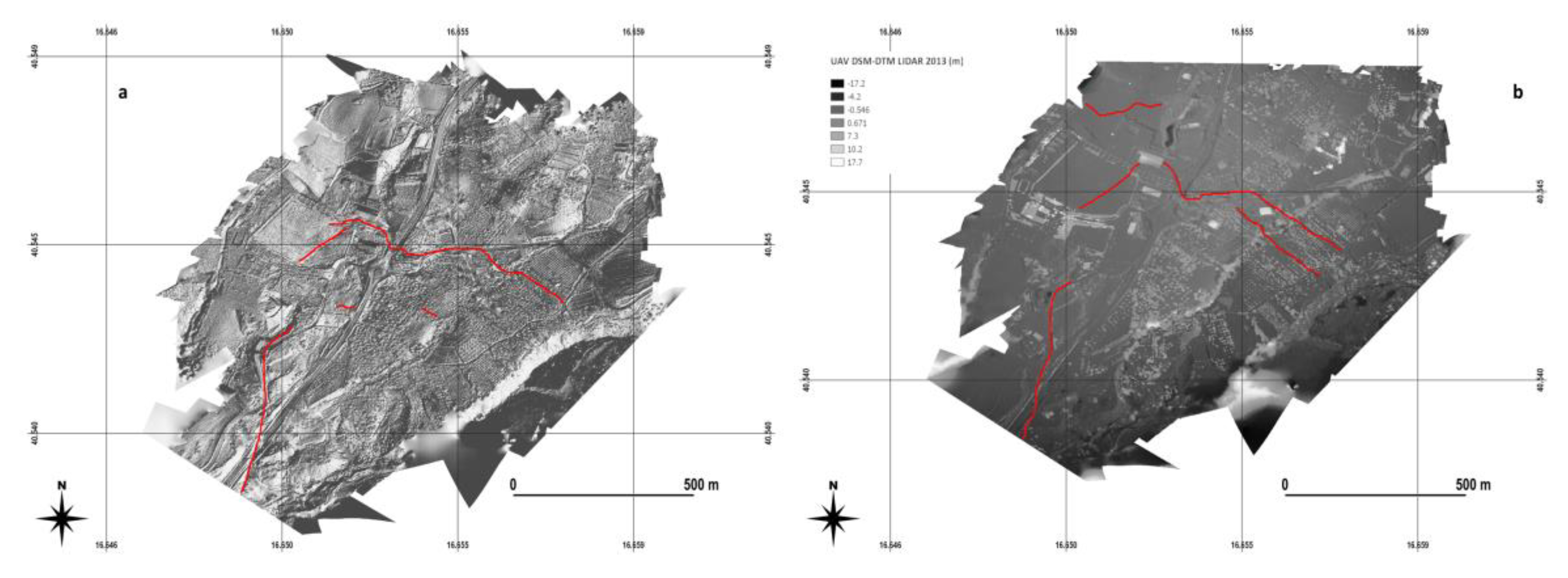

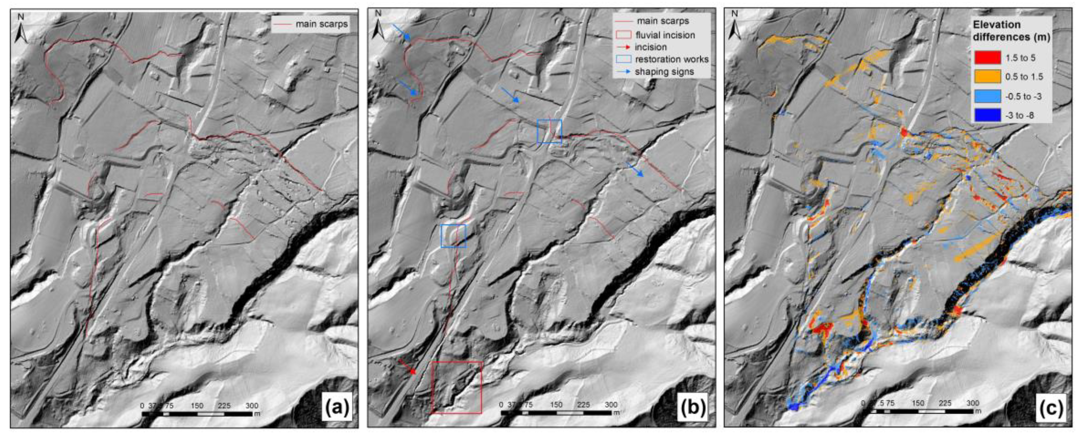
| Research Group | Activity | Result |
|---|---|---|
| CNR-IRPI | Field surveys and aerial photo interpretation | Geomorphological map |
| CNR-IRPI | Topographic monitoring with total station | Superficial displacements of 26 points |
| DST-UNIFI 1 and CNR-IMAA 2 | GBInSAR 3 | Superficial displacements |
| DST-UNIFI DST-UNIROMA 4 | InSAR with COSMO-SkyMed imagery | Superficial displacements |
| CNR-IRPI | Inclinometer monitoring | Deep displacements |
| DiCEM-UNIBAS 5 | Stratigraphical and hydrogeological analyses | Stratigraphic sequence, thickness of saturated aquifer |
| DiCEM-UNIBAS | TDR monitoring, gamma-log measures and borehole video inspections | Location of sliding surface |
| DiCEM-UNIBAS | Laser monitoring | Superficial displacements |
| LiDAR Summary | Technical Features |
|---|---|
| Vehicle | Twin engine P68B Victor Vulcanair aircraft |
| Sensors | 80 Mp resolution aerial camera-Phase One IXA 180 RIEGL LMS-Q680i Positioning and orientation system |
| Pulse repetition | 400 kHz |
| Scan speed | 185.2 Km/h |
| GSD | 0.9 m |
| Flight speed | 180 Km/h |
| Flight height | About 9000 Km |
| Post-processing software | RIEGL |
| UAV Summary | Technical Features |
|---|---|
| Vehicle | Expanded polypropylene motor glider “Bixler” |
| Sensors | Single board computer Ardupilot 16 Mp resolution camera Canon A2300 |
| Shutter speed | 1/2000 s |
| Acquisition rate | 4 s |
| Flight speed | 36 Km/h |
| Flight height | 130 m |
| Number of images | 1000 |
| Post-processing software | Agisoft’s PhotoScan |
| Survey | Pre-event LiDAR | 1st Post-event LiDAR | 2nd Post-event LiDAR | UAV |
|---|---|---|---|---|
| Date | July 2013 | 7 December 2013 (dec2013DTM) | 29 November 2016 (nov2016DTM) | 21 December 2013 to 5 February 2014 |
| Products | Orthophoto DTM (jul2013DTM) | Orthophoto DTM (dec2013DTM) | Orthophoto DTM (nov2016DTM) | Orthophoto DSM |
| Orthophoto | ||||
| Spatial resolution | 0.2 m | 0.12 m | 0.12 m | 0.5 m |
| DTM/DSM | ||||
| Planar accuracy | 0.2 m * | 0.3 m * | 0.3 m * | 0.5 m |
| Vertical accuracy | 0.3 m * | 0.3 m * | 0.3 m * | 1 m |
| Resolution | 5 m * | 1 m * | 1 m * |
© 2019 by the authors. Licensee MDPI, Basel, Switzerland. This article is an open access article distributed under the terms and conditions of the Creative Commons Attribution (CC BY) license (http://creativecommons.org/licenses/by/4.0/).
Share and Cite
Pellicani, R.; Argentiero, I.; Manzari, P.; Spilotro, G.; Marzo, C.; Ermini, R.; Apollonio, C. UAV and Airborne LiDAR Data for Interpreting Kinematic Evolution of Landslide Movements: The Case Study of the Montescaglioso Landslide (Southern Italy). Geosciences 2019, 9, 248. https://doi.org/10.3390/geosciences9060248
Pellicani R, Argentiero I, Manzari P, Spilotro G, Marzo C, Ermini R, Apollonio C. UAV and Airborne LiDAR Data for Interpreting Kinematic Evolution of Landslide Movements: The Case Study of the Montescaglioso Landslide (Southern Italy). Geosciences. 2019; 9(6):248. https://doi.org/10.3390/geosciences9060248
Chicago/Turabian StylePellicani, Roberta, Ilenia Argentiero, Paola Manzari, Giuseppe Spilotro, Cosimo Marzo, Ruggero Ermini, and Ciro Apollonio. 2019. "UAV and Airborne LiDAR Data for Interpreting Kinematic Evolution of Landslide Movements: The Case Study of the Montescaglioso Landslide (Southern Italy)" Geosciences 9, no. 6: 248. https://doi.org/10.3390/geosciences9060248
APA StylePellicani, R., Argentiero, I., Manzari, P., Spilotro, G., Marzo, C., Ermini, R., & Apollonio, C. (2019). UAV and Airborne LiDAR Data for Interpreting Kinematic Evolution of Landslide Movements: The Case Study of the Montescaglioso Landslide (Southern Italy). Geosciences, 9(6), 248. https://doi.org/10.3390/geosciences9060248


