1. Introduction
Several of the upland areas in Campania (Southern Italy) are covered by air-fall pyroclastic deposits in unsaturated conditions which are periodically subjected to rapid landslides triggered by heavy rainfalls. Some of these landslides evolve into catastrophic flowslides, involve long distances on flat areas and cause extensive damage to downslope towns [
1,
2,
3,
4]. However, not all landslides triggered by the same rainfall events in the same geomorphological contexts evolve into flowslides. Many stop at the toe of the slopes and cause no significant damage to the population [
5].
The crucial reliability of forecasts provided by physically based models used by early warning systems for civil protection purposes depends on the ability of early warning systems (EWSs) to reproduce the physical phenomena, taking into account the peculiarity of pyroclastic soil particles and controlling:
In two hillslope areas about 30 km from Naples, the availability of experimental observations from the laboratory and in situ investigations [
6,
7,
8] as well as from flume infiltration tests on small-scale slope models [
9,
10] allowed appropriate definition, calibration and validation of physically based models. The two pyroclastic deposits analysed were involved in the catastrophic flowslides of Sarno in 1998 and Cervinara in 1999. On the basis of the experimental results, for both cases, two “reliable” hydrogeotechnical models have been proposed to analyse the slope response of loose unsaturated pyroclastic deposits. All the experimental results related to the two soils were then arranged in a dataset scheme, reported in
Section 6, to be implemented in a soil database. In the literature, several kinds of geological and geotechnical soil databases are already available, but they mainly concern geological aspects or geotechnical physical and mechanical properties retrieved from conventional laboratory tests on saturated samples or in situ tests. However, in the case of shallow rainfall-induced landslides in the pyroclastic soils of Campania, the need to analyse the complex process of infiltration into a partially saturated deposit up to instability and the following undrained soil response, which can be considered responsible for flowslide generation, makes it indispensable to give further information about soil properties in unsaturated conditions and about the discriminator elements for evaluation of the potential susceptibility of the natural soil deposit to evolve into a flow.
These soil databases and the related geotechnical model constitute the elements to improve the existing EWSs. Although the extension of such a database at the regional scale requires a major effort that may be considered costly for the community, there are undoubted economic benefits deriving from the use of well-calibrated physically based models in the implementation of EWSs.
The first part of the paper briefly reviews the literature concerning the geotechnical models for analysing slope responses in granular deposits and shows that the conventional approaches proposed are not strictly applicable in the case of flowslides in the pyroclastic deposits of Campania. In the second part of the paper, the two geotechnical models for pyroclastic soils obtained by the complex experimental programme, including in situ and laboratory investigations, are presented. In the third part, the economic benefits deriving from the use of well-calibrated physically based models in the implementation of early warning systems are introduced. The paper concludes with the soil database description, the presentation of the geotechnical framework to be implemented in EWSs and an example of validation.
2. Models for Analyses of Saturated and Unsaturated Slopes
In granular shallow deposits, slope response to rainfall is a complex hydrogeological and geotechnical process, even for very simple slope geometries and geological structures of subsoil. Each event causing a change in boundary conditions (precipitation, change of humidity, air pressure, temperature and other weather variables) can induce different slope responses in terms of states of stresses and strains in turn related to the initial state of the slope. For each event, the initial state of the slope is a function of stresses and strain history preceding the event itself. These two considerations highlight the need to evaluate slope stability by resorting to constitutive models able to properly assess the evolution of stresses and strains for a forecasted rainfall, using as initial condition data from monitoring and the analyses of slope response history preceding the event.
To this end, hydrogeotechnical models have been widely proposed in the literature for the analysis of slope response in granular deposits subjected to infiltration. Differently from the last century, when the evolution of slope stability was generally analysed under the hypothesis of fully saturated conditions and homogeneous and isotropic soil, in recent decades, several more or less simplified infiltration models have been developed to analyse slope response under transient (but uncoupled) unsaturated flow [
11,
12,
13,
14,
15]. Based on the results of these infiltration models, slope stability analysis can be performed by using simplified approaches that consider the effect of the stress state variable (normal stress and matric suction) on shear strength [
16,
17], approaches that combine suction and mean net stress in effective stress [
18] or approaches where the shear strength changes due to matric suction are directly derived from the soil-water characteristic curve (suction stress-based effective stress (SSCC); [
19,
20]). These simplified infiltration models require few parameters of clear physical meaning to be defined. Although they do not allow all the physical aspects of the phenomena to be described, they can provide acceptable results in EWSs for very simple slope geometries and geological structures of subsoil if the parameters are experimentally defined and the models are appropriately calibrated.
In parallel, in the last few decades, more complex models have been developed that use fully coupled hydromechanical models [
21,
22,
23,
24]. Some of these models should be able to reproduce a large part of the physical phenomena in question even if they require a greater number of parameters to be defined, some of which have no clear physical meaning. They can be used in EWSs and also in complex slope geometries and geological structure of subsoil. However, defining the parameters requires the development of more complex experimental programmes and also in-depth calibration of the model on data from in situ monitoring (which is unlikely to be always done).
Starting from this excursus, the experimental programme presented in the paper seeks to answer the following questions:
- (1)
Could one of these models be implemented in an EWS to predict the instability (landslide) of pyroclastic deposits subjected to infiltration?
- (2)
Can the implemented models predict the postfailure evolution into a flow-type movement?
- (3)
Does the experimental programme also provide sufficient information to estimate the postfailure evolution into a flow-type movement?
3. Materials and Methods
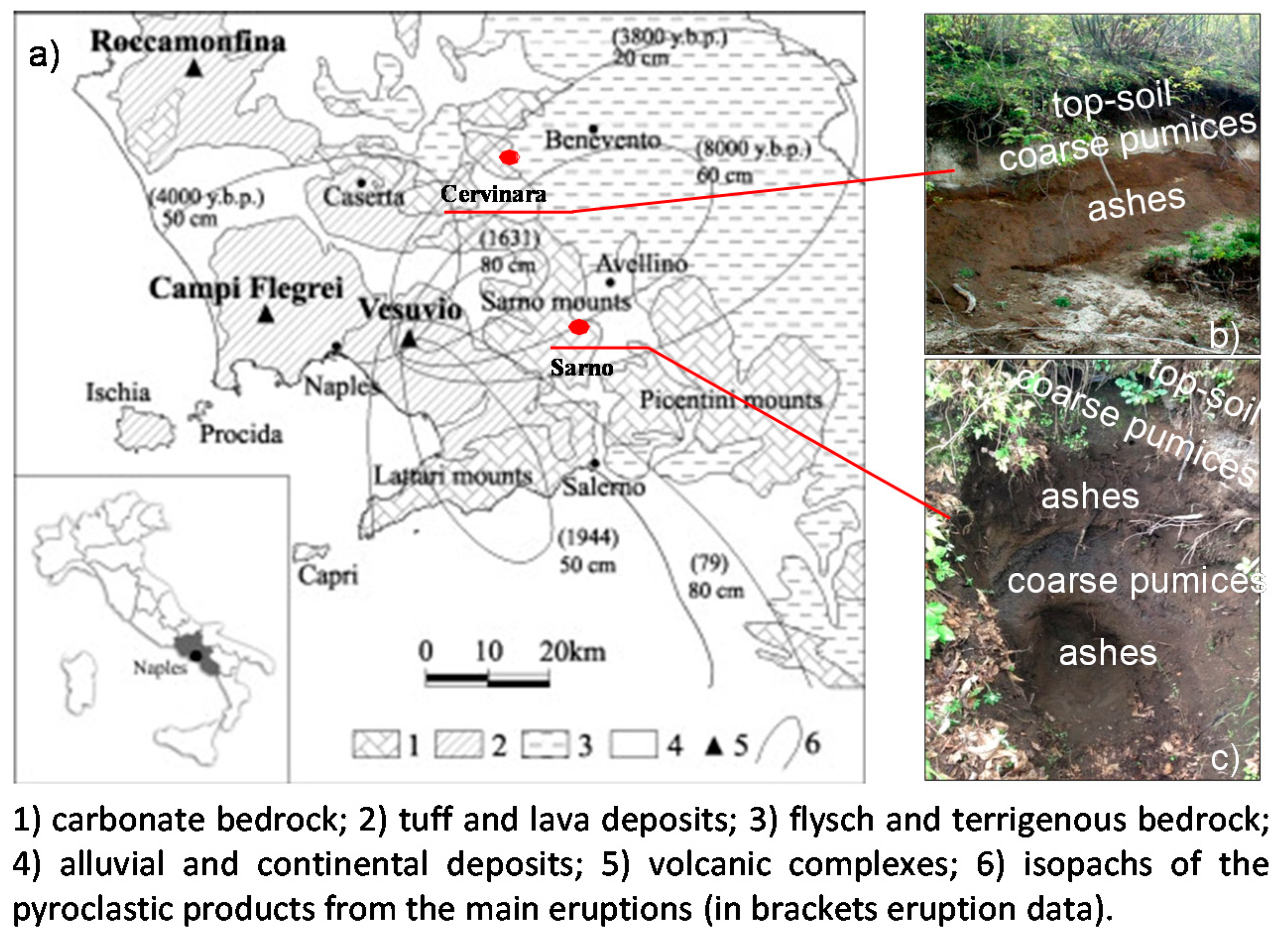
Analysis of the mechanical characteristics of two air-fall deposits was performed by means of a complex experimental programme. The two investigated slopes of Cervinara and Sarno-Tuostolo are, respectively, located in the Partenio and Sarno Mountains northeastward from the Mt. Vesuvius volcano, as illustrated in
Figure 1a, which shows a schematic geologic map of the area [
25]. The covers are only a few metres thick (from 2 up to 5 m) and consist of alternating pumice (gravelly sand) and ash (silty sand) layers, lying on intensely fractured limestone (bedrock). We mainly focused on the ash layers which, in the sequences, are considered to be responsible for the evolution into flowslides [
6]. The soil specimens were sampled into two handle-made cuts along the slopes (
Figure 1b,c): the geographical coordinates of the sampling points, as well as the characteristics of the cover and the layer in terms of mean slope angle, thickness of the cover and position and thickness of the ash layer at the sampling points, are reported in the first frame of the dataset illustrated in
Section 6.
The mean physical and state properties of the investigated soils are reported in
Table 1 and in the second frame of the dataset (
Section 6) in terms of maximum diameter of soil
dmax, unit weight of soil volume
γ, water content
w, porosity
n and degree of saturation
Sr. In both cases, the ashes are characterised by a surprisingly high porosity (about 70%) and a relatively low specific unit weight of the soil particle (about Gs = 2.6). These properties are typical of a metastable structure responsible for flowslide generation. Also, the grain-size distributions of the two ashes indicate that the materials, both classified as silty sand, can be considered susceptible to liquefy. Indeed, the grain-size distributions of the Cervinara and Sarno ashes are compared in
Figure 2 with those of natural deposits susceptible to liquefaction under monotonic and cyclic loading [
26,
27]. The comparison shows that the grain-size distributions of the soils in question fall within the range of variation of liquefiable deposits.
The Experimental Programme
According to the abovementioned considerations, the experimental programme performed on the two volcanic ashes had the following aims:
to define the saturated shear strength;
to verify the susceptibility of the two volcanic ashes to static liquefaction;
to define the role of suction on shear strength; and
to define the water retention curves and permeability functions.
To achieve such goals, for both deposits (Cervinara and Sarno), the experimental programme provided, in addition to the conventional tests of identification and definition of physical properties, saturated triaxial compression (TX) tests and suction-controlled triaxial (SCTX) tests.
The triaxial tests were performed on natural soils with an initial void index ranging between 2.05 and 2.14. The soil samples were taken using thin-walled tube sampling of the same size as the specimens for triaxial apparatuses (36–38 mm in diameter for TX; 70 mm in diameter for SCTX). In the case of granular unsaturated soil samples, it was thus possible to minimise the disturbance induced by consecutive operations of sampling, extrusion and diameter reduction.
In the case of saturated triaxial tests, the specimens were directly saturated in a triaxial apparatus, applying a wetting stress path characterised by always lower net stress, suction and effective stresses than those acting in situ. This was essential to use the results of triaxial tests to analyse the potential liquefaction of natural deposits. In these tests, mean effective stresses ranging between 30 and 125 kPa and 50 and 200 kPa for Cervinara and Sarno soils, respectively, were applied.
In the experimental programme on unsaturated soil performed in the suction-controlled triaxial apparatus (SCTX), the applied mean net stress (p − ua) ranged between 10 and 90 kPa for Cervinara and 30 and 50 kPa for Sarno, whereas the suction (ua − uw) ranged between 10 and 80 kPa for Cervinara and 10 and 50 kPa for Sarno.
To accurately define the water retention curve of the soils, data from the tests described below were compared:
- -
suction-controlled triaxial tests;
- -
conventional infiltration and drying tests on small-size specimens (50 cm3); and
- -
flume infiltration tests in physical models on large reconstituted specimens (>50,000 cm3).
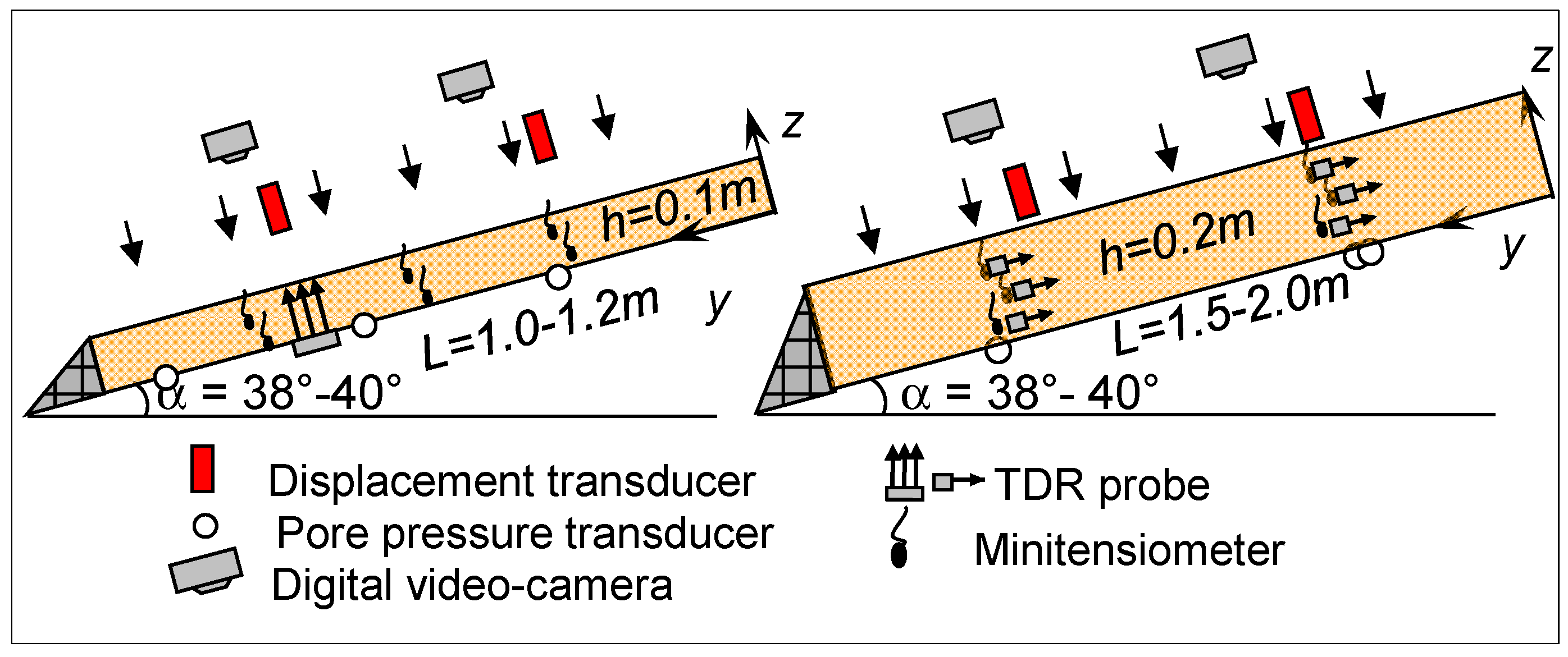
In the infiltration tests, soil deposits reconstituted at different porosities (between 70% and 76%) by a moist-tamping technique were tilted at an angle of 38° and subjected to uniform artificial rainfall (ranging between 55 and 60 mm/h) till their complete saturation. The main characteristics of the tests are summarised in
Table 2, whereas the instrumented flumes are presented in
Figure 3. The apparatuses were equipped with laser displacement sensors which monitored settlements of the ground surface, pore water pressure transducers installed at the base of the layer and several minitensiometers and time-domain reflectometer (TDR) probes placed at different locations and depths for suction and volumetric water content measurements. More details about the apparatuses, the reconstitution technique and the test procedure may be found in [
28,
29,
30].
Finally, only for the Cervinara ash, in situ measurements of suction and volumetric water content are available [
31]. They were used for water retention characterisation of the soils to validate the model.
4. Experimental Results
4.1. Shear Strength (Sr = 1)
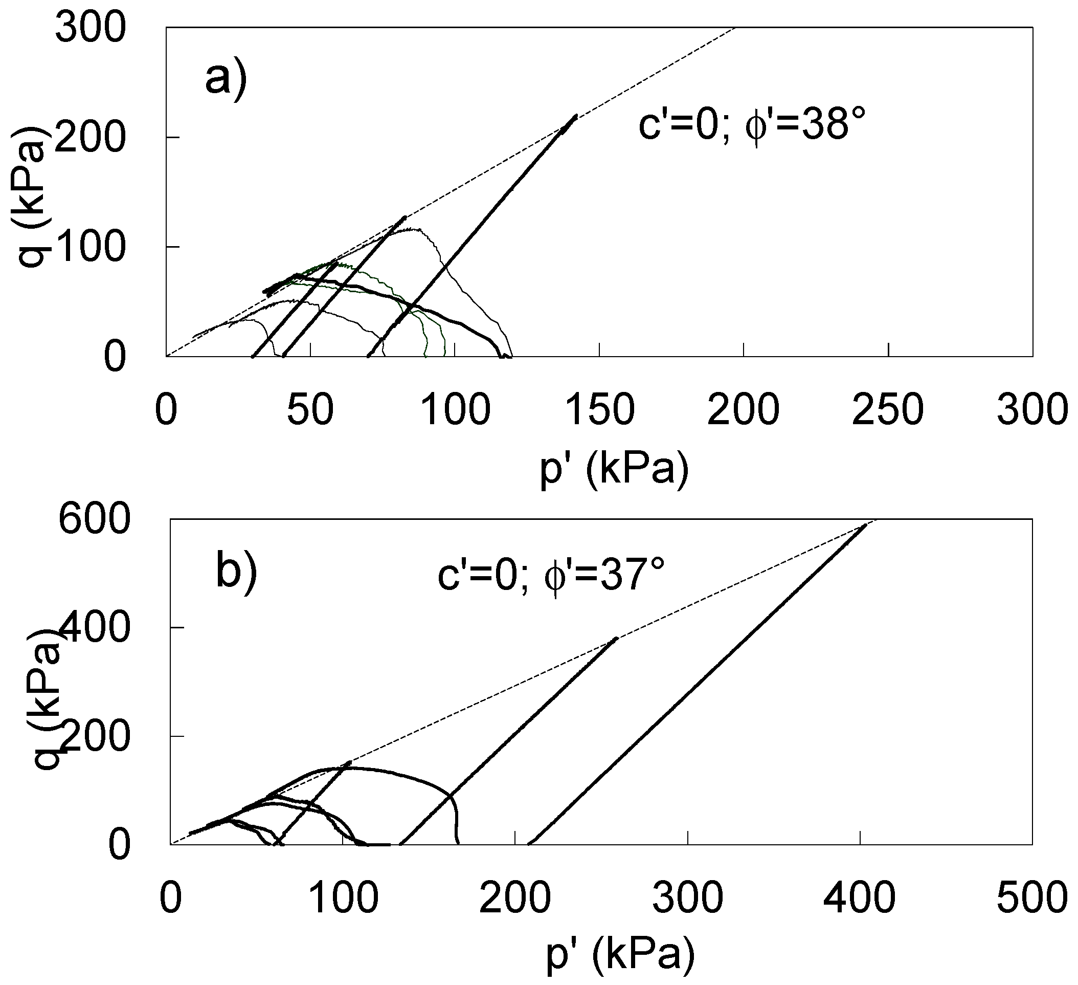
Saturated shear strength was measured in drained (CID) and undrained (CIU) triaxial tests on isotropically consolidated natural specimens. The results in terms of stress paths are reported in the stress plane in
Figure 4. In drained conditions (CID in
Figure 4), both materials showed a high friction angle (37°–38°) and a nil value of cohesion intercept. Such high friction angles were justified in the subangular shape with sharp edges of pyroclastic particles typical of fall deposits and in the negligible influence of fine components due to low plasticity.
In the same stress plane (
Figure 4), the stress paths of undrained tests (CIU) and the corresponding envelopes of strength are reported. A homogeneous response confirmed the uniformity detected in the physical properties of the two materials. Approaching the failure envelope (drained), an undrained instability occurred with a progressive reduction in the shear stress that moved along the steady-state line (or CSL) towards the origin of the axes (static liquefaction). Such undrained instability was also observed for a range of stresses comparable with those acting in situ, confirming a high susceptibility to liquefaction of both deposits.
With this first part of the experimental programme, the first “ingredients” considered “essential” were identified:
- -
the properties of these two materials (high porosity and low specific weight) are typical of soils susceptible to liquefaction;
- -
the grain-size distribution of these two soils fall right in the middle of the range for potentially liquefiable soils; and
- -
the undrained instability from tests on undisturbed samples in a range of stresses comparable to in situ stresses confirms the high susceptibility to liquefaction.
After instability, as described in the framework proposed by Olivares and Damiano [
6] such deposits have a high probability of evolving into a flowslide if the following conditions establish:
water content near saturation at failure; and
low ability to dissipate the excess pore pressure generated by the shear strain rate induced by slope movements and the consequent ability to develop pore pressure.
Therefore, to analyse the infiltration processes that lead to failure conditions, it is essential to consider constitutive relationships, including the effects of partial saturation on shear strength and on hydraulic conductivity. Particular attention must be given to the definition of water retention curves and functions of permeability. To further underline these concepts, the framework to be implemented in EWSs was modified from the original one [
6] and is described in
Section 6.
4.2. Shear Strength (Sr < 1)
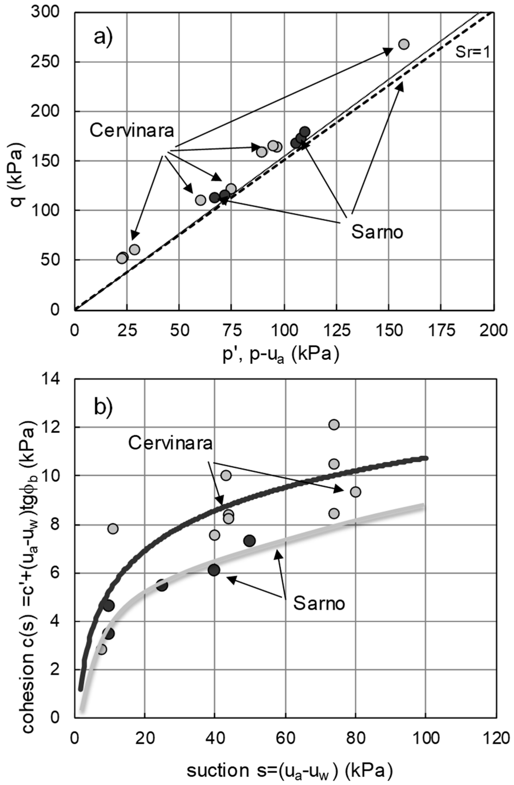
For both sites, the effect of partial saturation on shear strength was defined in SCTX tests on natural samples 70 mm in diameter. In the stress plane, the results for suctions ranging between 10 and 80 kPa and mean net stress between 20 and 80 kPa are reported (
Figure 5a). For the purpose of comparison, in the same stress plane, the two envelopes of saturated shear strength are reported. In conditions of partial saturation, all the representative points of failure conditions were localised in the stress plane well above the saturated shear strength envelope, emphasising the non-negligible role of suction in volcanic ash soils. In
Figure 5b, the intercept cohesion is shown as a function of suction (“apparent cohesion”). This result was obtained by assuming shear strength envelopes for partially saturated soils parallel to the saturated envelope passing through failure conditions. In both soils, the relationships between cohesion intercept and suction showed a strongly nonlinear monotonic increase in cohesion intercept. In the case of Cervinara, cohesions slightly greater than 10 kPa were obtained by suctions of 70 and 2–6 kPa by suction of 4–8 kPa. In the case of Sarno, as for the saturated shear strength, slightly smaller values are reported (intercept cohesion assumes values of 7 kPa for a suction of 50 kPa). These “apparent cohesions” are sufficient to justify the stability of shallow deposits even for suctions very close to zero. Nonlinear relationships of this kind can easily be implemented within hydrogeological models capable of describing the evolution of slope stability due to rainfall infiltration (see soil data-base in
Section 6).
4.3. Water Retention Curves and Permeability Functions
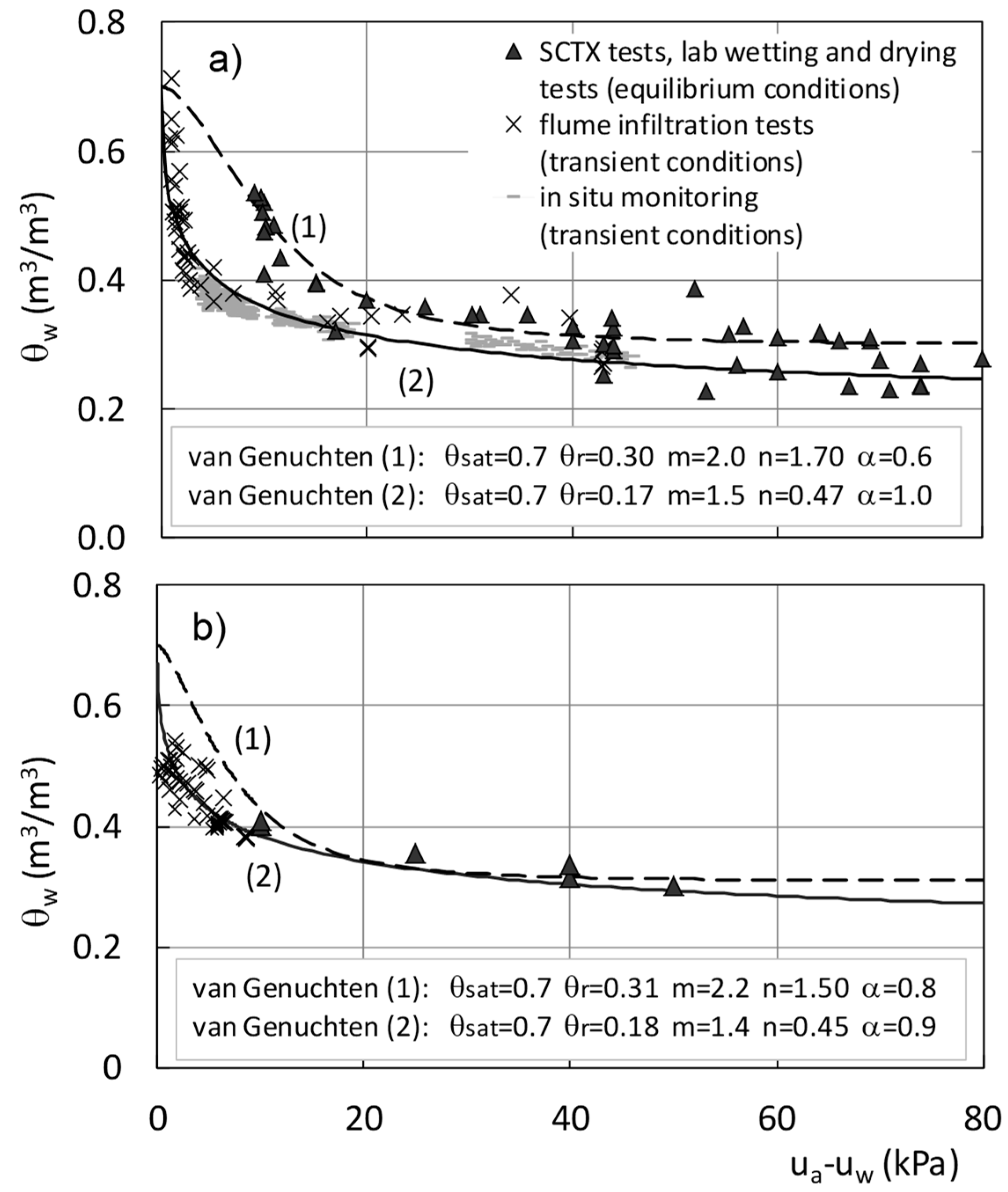
The relationships between suction and volumetric water content are analysed in
Figure 6 for both materials. Data from SCTX tests and from conventional laboratory wetting and drying tests were retrieved. In SCTX tests on natural soil specimens 68 mm of diameter, the values of water content at the end of equalization due to the applied increments or decrements of suction were considered. In wetting and drying tests on reconstituted soil specimens (dx = dy = dz = 10 cm), experimental points were obtained only for the Cervinara ash by coupling suction measured by a minitensiometer inserted within the soil sample with the gravimetric water contents. Data were fitted by the van Genuchten expression [
32], leading to curve 1 in
Figure 6a,b, respectively, for the Cervinara and Sarno ash. Both soils showed comparable trends and allowed a quantitative description of the functional relationship for values of suctions greater than 10 kPa.
To investigate the soil water retention curve (SWRC) close to saturation, other data series were retrieved from infiltration tests on small-scale model slopes. Experimental points were obtained by coupling volumetric water content measurements from time-domain reflectometer (TDR) probes and suction measurements from “small tip” tensiometers installed close to each other (
Figure 3). Also, these series of data are reported in
Figure 6. It can be noted that the experimental points for both materials seem to cluster along different curves (curves 2 in
Figure 6) located above those retrieved fitting data from laboratory tests. This can be attributed to the different applied rates of suction variation. Indeed, in the case of triaxial and conventional wetting and drying tests on small specimens, changes of suction or of water content were imposed for long times of equalization, up to the attainment of an equilibrium condition. On the contrary, in the case of flume tests, we analysed, in a point within the soil deposit, the evolution of suction and water content during the transient regime induced by rainwater infiltration.
Taking into account the microstructure of pyroclastic particles, it is possible to imagine wetting processes which, in the case of triaxial and conventional wetting and drying tests, have low changes of water content and long exposure times to reach an equilibrium condition able to engage both macropores between the particles and the smaller pores within the particles themselves. Greater suction corresponds to a higher exposure time for a given water content.
Moreover, different specimen sizes and different boundary conditions may well explain the differences between the two datasets (relationships 1 and 2 in
Figure 6; Damiano and Olivares [
33]). We consider more reliable the experimental dataset coming from the infiltration tests on small-scale model slopes (curve 2 in
Figure 6) to reproduce the on-site SWRC, as it was obtained for boundary conditions closer to real slope conditions. This also appeared to be confirmed by the fact that this last dataset, fitted by curve 2, fell close to the dataset from monitoring of the Cervinara slope (light blue points in
Figure 6a).
In any case, the relationships described a typical granular soil response with a low air entry pressure and wide transition zone, confirming for both soils the similarities already found for the other mechanical properties. The influence of the nonplastic fine fraction was evident with water contents ranging between 0.2 and 0.3, even for high suction values.
All the information retrieved from this part of the experimental programme is available in the Soil Database of
Section 6, where the van Genuchten parameters associated with the best approximation (curves 2 in
Figure 6) are reported together with an evaluation on their reliability.
The permeability functions (last “ingredients”) are analysed in
Figure 7. In the same SCTX tests, hydraulic conductivity was determined by the expression proposed by Kunze et al. [
34], analysing the transient regimes induced for each increment of suction. For the sake of comparison, in the same figure, the values of the unsaturated conductivities retrieved by using the Brooks and Corey [
35] and the Gardner [
36] relationships are reported. It can be seen that, starting from the saturated value (about 10
−6 m/s), the hydraulic conductivity markedly decreased up to 10
−8 m/s (under suctions of 50–80 kPa). The results for both Cervinara and Sarno ashes are comparable, providing quantitative functional relationships which may be easily implemented in a soil model.
5. The Socioeconomic Value of Early Warning Systems
Not only may rainfall-induced landslides produce adverse technological and productivity shocks (of different frequencies and intensities), but so too can false alarms of such catastrophic events, reducing present and future values of investments and projects in the areas concerned by bringing activity to a sudden and unexpected halt. Although such uncertainty could suggest it would be better to indefinitely postpone economic activities in those areas, it makes the development of effective EWSs as an ex ante solution to help economic development even more important.
Indeed, in the Dixit and Pyndick [
37] and Hull [
38] framework of real options, an effective EWS can be considered as a tool to embed the value of “temporary abandonment options” in projects and investments. This will encourage economic activities rather than defer them forever. Moreover, such an EWS will be able to highlight long “periods of peace”, increasing the net value of projects of the embedded “options to expand” and “extend”. Correct evaluation of the natural hazard risks to which activities may be actually exposed will help management to increase productive capacity, to increase the scale of a project’s operation, to extend the life of the assets without hesitation (during any positive phases of their business cycle) and to do so at lower costs (e.g., lower insurance premiums and higher economies of scale). By contrast, the EWS could inform management promptly of the advisability of reducing the scale of their operations by embedding a “contraction option” in its value.
In the absence of an effective EWS, the only way to reduce the value at risk is to abandon those areas potentially exposed to natural hazards. Hence, the development of these areas may be severely compromised (poverty traps). By contrast, natural risk exposure may be addressed and mitigated through an effective EWS. Management receiving correct and timely information will not be conditioned by excessive under- or overestimation of the true value at risk.
Another aspect to be considered is that a large part of the costs of implementing EWSs has already been sustained (e.g., meteorological monitoring and university research). Hence, the present and future benefits will certainly exceed costs yet to be incurred.
So much for the positives. Due to the fact that they overlook geotechnical and hydrological aspects, existing EWSs are not really effective and, what is worse, may trigger false alarms and, hence, the dreaded negative technological and productivity shocks. This happens essentially because the true nature of the soils is not considered and still remains confined in a “black box”. Moreover, the triggering thresholds are only defined on the basis of a time series of rainfall events and extremely simplified analysis of infiltration processes and stability conditions of slopes (i.e., only in saturated conditions).
The study of the response of nonsaturated soils would allow better characterisation of the triggering mechanisms of landslides induced by extreme meteorological events and lead to a less uncertain environment in which researchers could formulate their expectations (beliefs and priors) to implement correct calibration and support decisions.
The reliability of an EWS strictly depends on adopting realistic hydrogeotechnical models (e.g., for unsaturated soils) that enable researchers to detect the right triggering thresholds and minimise the risk of false or late alarms [
7,
9]. Better evaluation of the value at risk will help reduce investment costs (e.g., lower insurance premiums and timely, appropriate safety measures).
The huge and irreversible sunk costs of catastrophic events, such as flowslides, and the very high present and prospective payoffs from implementing reliable EWSs suggest that this kind of social investment should no longer be postponed.
6. Presentation of the Soil Database and the Framework to Assess Failure and Postfailure Evolution
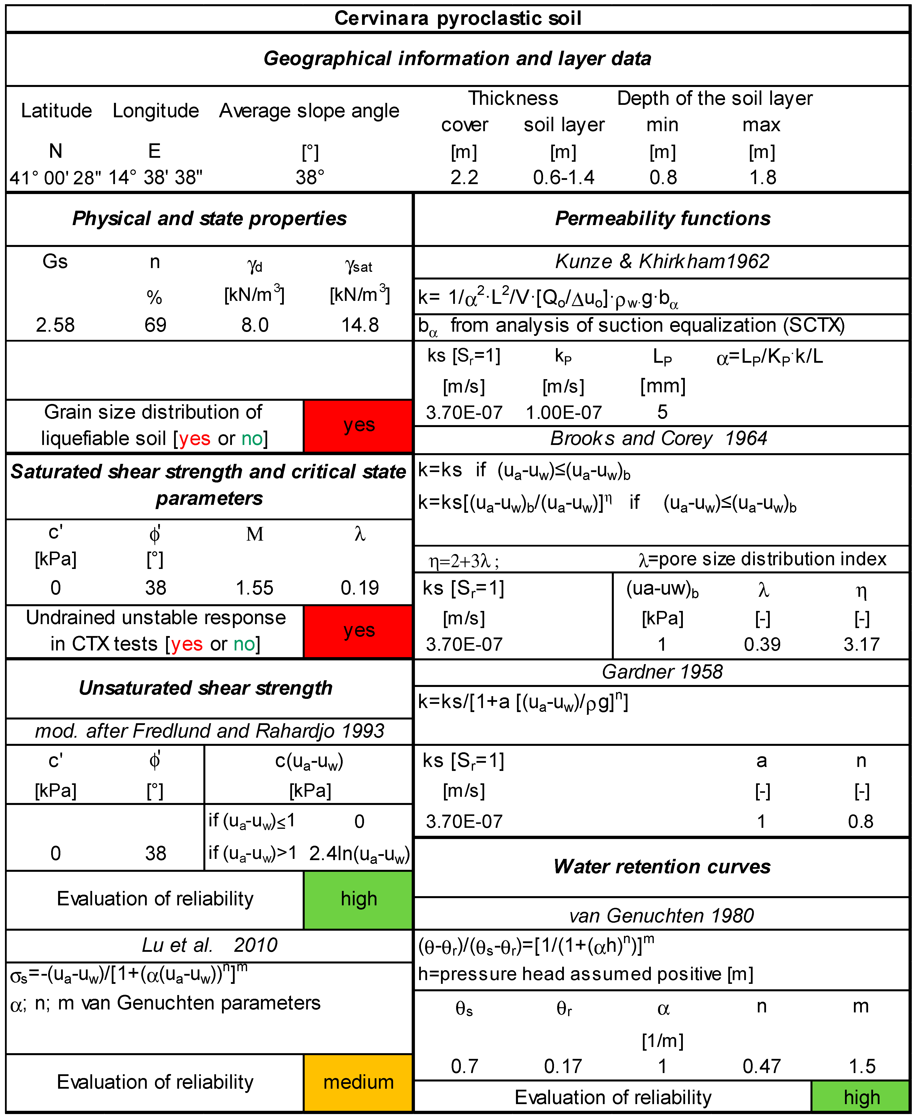
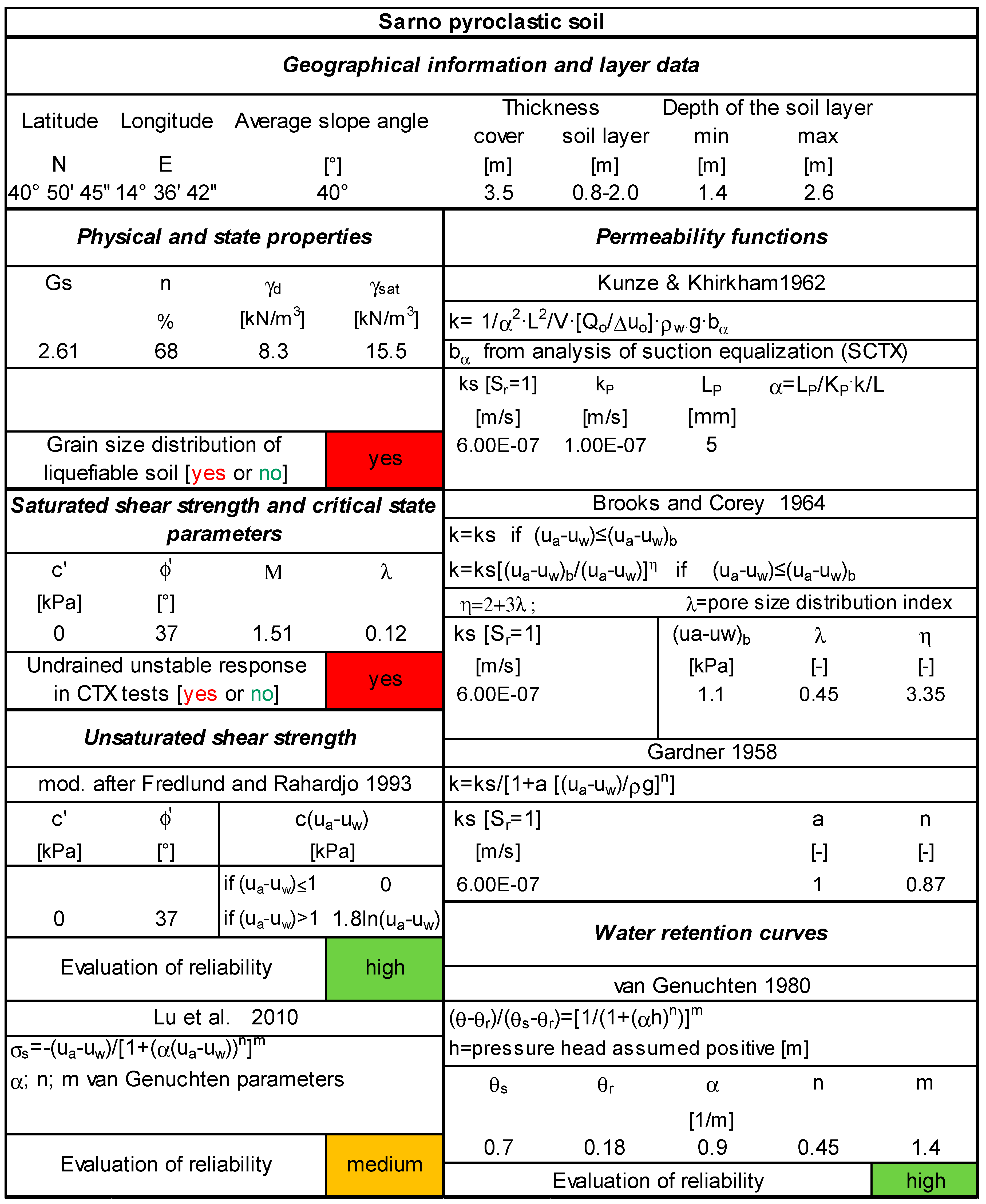
Using the data reported in
Section 3 and
Section 4, an example of a soil database (SDB) for implementation in an early warning system (
Figure 8 and
Figure 9) is presented. In addition to the classic geographic and geometric information that identifies the slope and the pyroclastic deposit, as well as the information on physical and state properties (that can be found in any soil database), we supplement the SDB with the evaluation of susceptibility to liquefaction, the engineering properties including the corresponding relationships, parameters and evaluation of reliability.
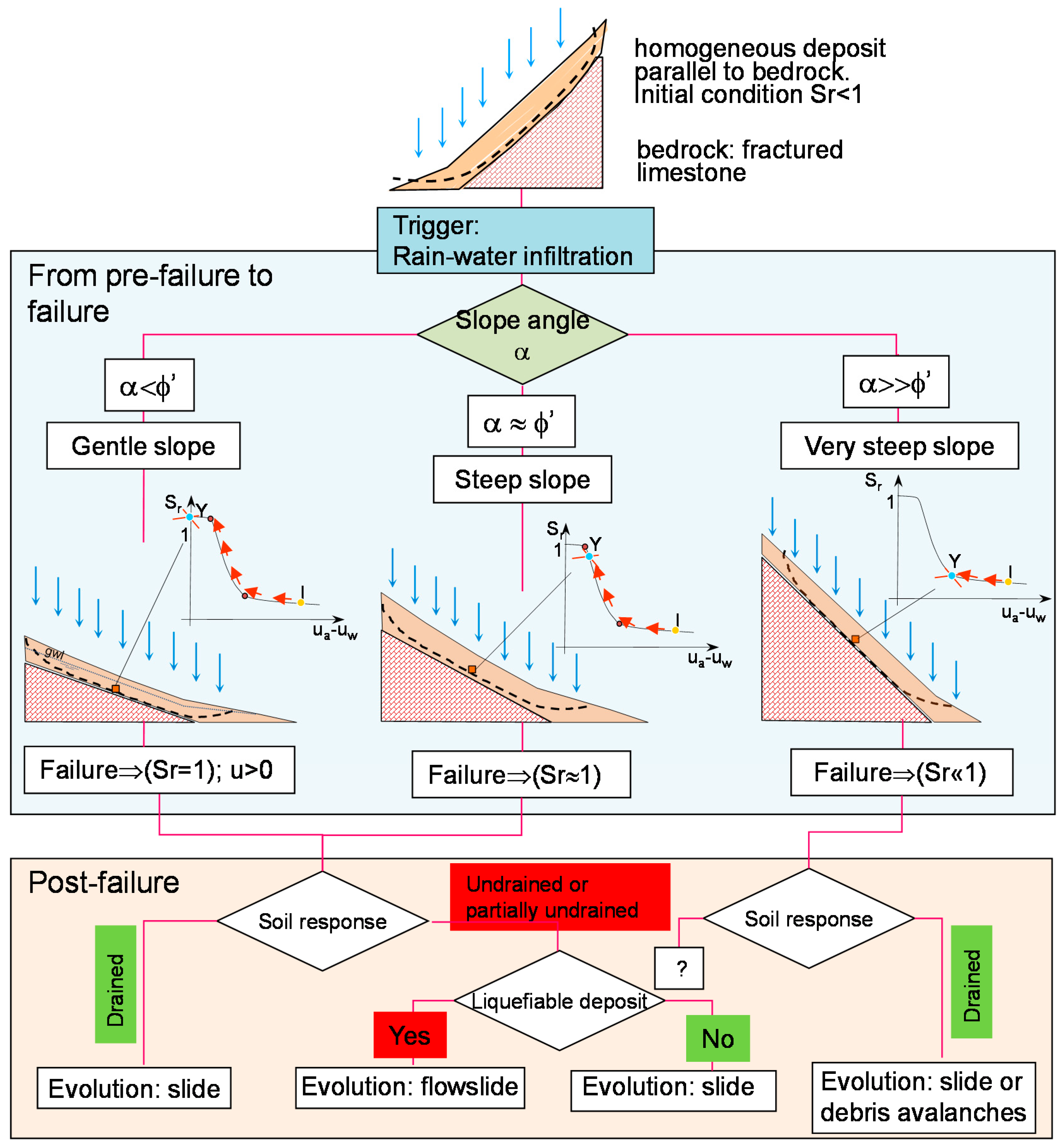
To try to understand how to use the SDB, a framework is presented below for defining the failure conditions and potential postfailure evolution (
Figure 10). This framework (modified from Olivares and Damiano [
6]) was developed for homogeneous deposits parallel to bedrock (fractured limestone) under rainfall infiltration starting from unsaturated conditions.
Scrolling the flowchart of
Figure 10 from top to bottom, first of all, we find the analysis of the infiltration process. This can be carried out with one of the models analysed in
Section 2. With the stress states obtained by analysing the infiltration process, it is possible to perform rainfall-instability analyses and to evaluate the postfailure evolution.
All the information to be used in the framework for activating the different functional relationships is contained in the SDB. As an example, we seek to analyse the case of Cervinara by scrolling the flowchart of
Figure 10 with the information contained in the SDB. Referring to the hypothesis of a homogeneous deposit parallel to the bedrock, it is possible to perform a rain-infiltration analysis. The SDB reports all information for the use of more or less simplified models to analyse the slope response to rain infiltration taking into consideration the effect of partial saturation conditions. Unfortunately, some of these approaches are not applicable for slope analyses in Campania due to the peculiarity of the pyroclastic deposits. As an example, Damiano et al. [
31], deriving the shear strength characteristics directly from the parameters that describe the soil-water characteristic curves, showed that the SSCC approach leads to a strong underestimation of shear strength, especially for low states of stress, demonstrating the inability of this simplified method to be implemented in an EWS to predict instability (in the box for unsaturated shear strength, the model of Lu et al. [
20] is considered to be of medium reliability). Other models can be used if the effects of partial saturation on shear strength have to be investigated separately through the effects on soil-water characteristic curves (in the box for unsaturated shear strength, the model modified from Fredlund and Rahardjo is considered to be of high reliability). With the stress states obtained by the infiltration processes, it is possible to perform rainfall-instability analyses.
In the framework, we consider three different failure scenarios according to slope morphology and soil friction angle:
- (1)
gentle slope (i.e., slope angle lower than the friction angle);
- (2)
steep slope (i.e., slope angle near or slightly greater than the friction angle); and
- (3)
very steep slope (i.e., slope angle significantly larger than the friction angle).
As reported in Olivares and Damiano [
6], in the first two scenarios, if failure occurs, the probability of developing a postfailure evolution into a flowslide exists if the deposit is susceptible to liquefaction (referring to the paper for details). By contrast, on a very steep slope, evolution into a flowslide is highly unlikely. The soil has typical characteristics of cohesionless granular soil susceptible to liquefaction. In the first box of the SDB (physical and state properties), the soil presents high porosity (about 70%), a reduced specific weight and the grain size distribution of liquefiable soil. In the second box of the SDB (saturated shear strength), it can be checked that the undrained response in triaxial tests of the soil is unstable. This information for gentle slopes or steep slopes activates the postfailure evolution into a flowslide in the flowcharts (red box “Yes” in
Figure 10).
Regarding the infiltration analyses and the use of different models (
Section 2), in 2013, during the third edition of the Italian Workshop on Landslides (3rd IWL), a session was dedicated to a Round Robin test on landslide hydrological modelling [
39,
40]. The participants from several European universities were provided with the “essential ingredients” reported in the SDB to simulate both the experiments carried out in a small-scale model slope and the response of the Cervinara slope to a measured precipitation event [
41]. The participants were asked to calibrate their models on the basis of the data provided in SDB and were challenged to simulate the results of the infiltration tests and slope response to assigned records of precipitation and temperature data. The best agreement was obtained by Villarraga et al. [
42], who used a fully coupled thermohydromechanical model implemented in the finite element code Code_Bright [
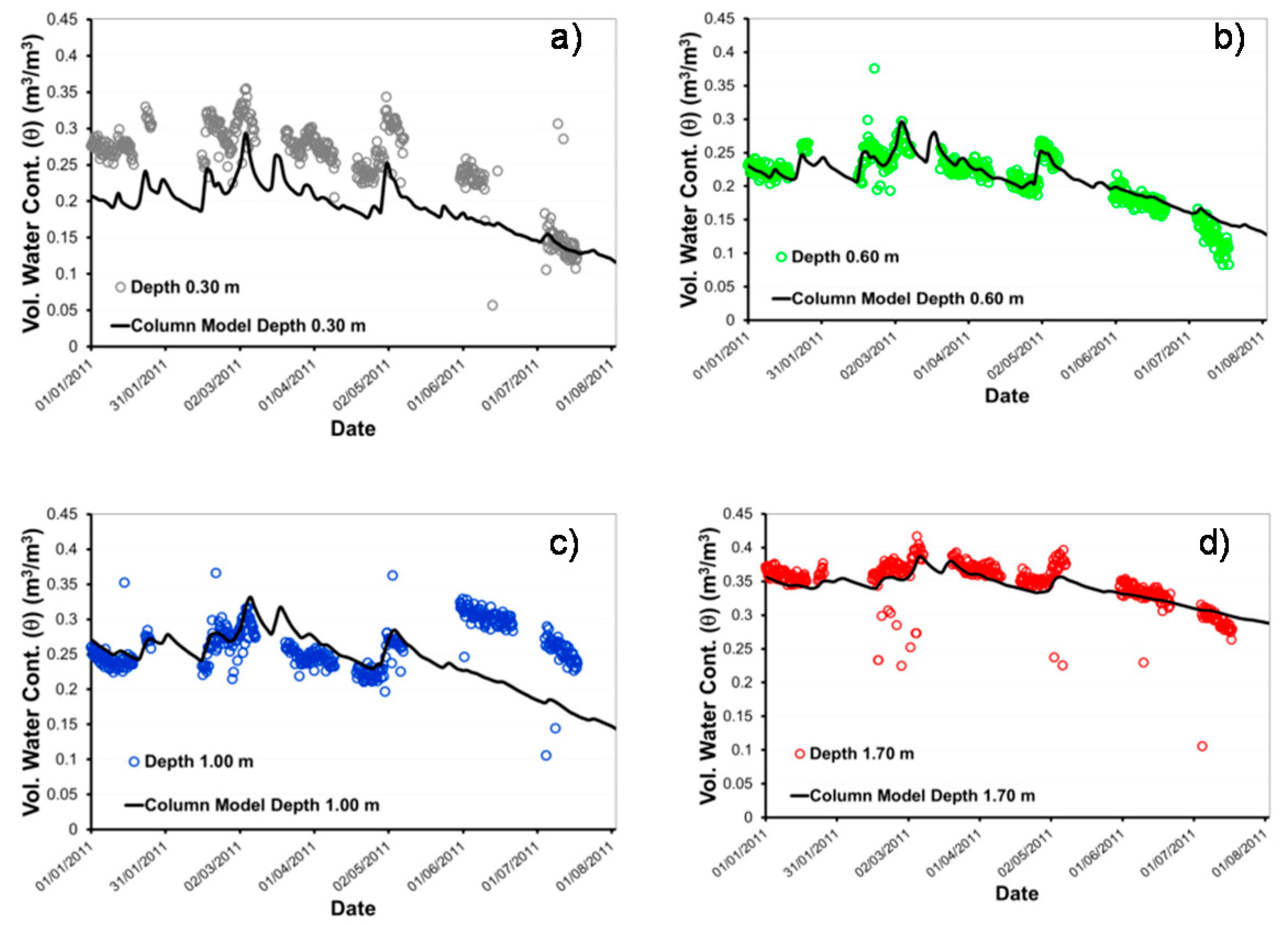
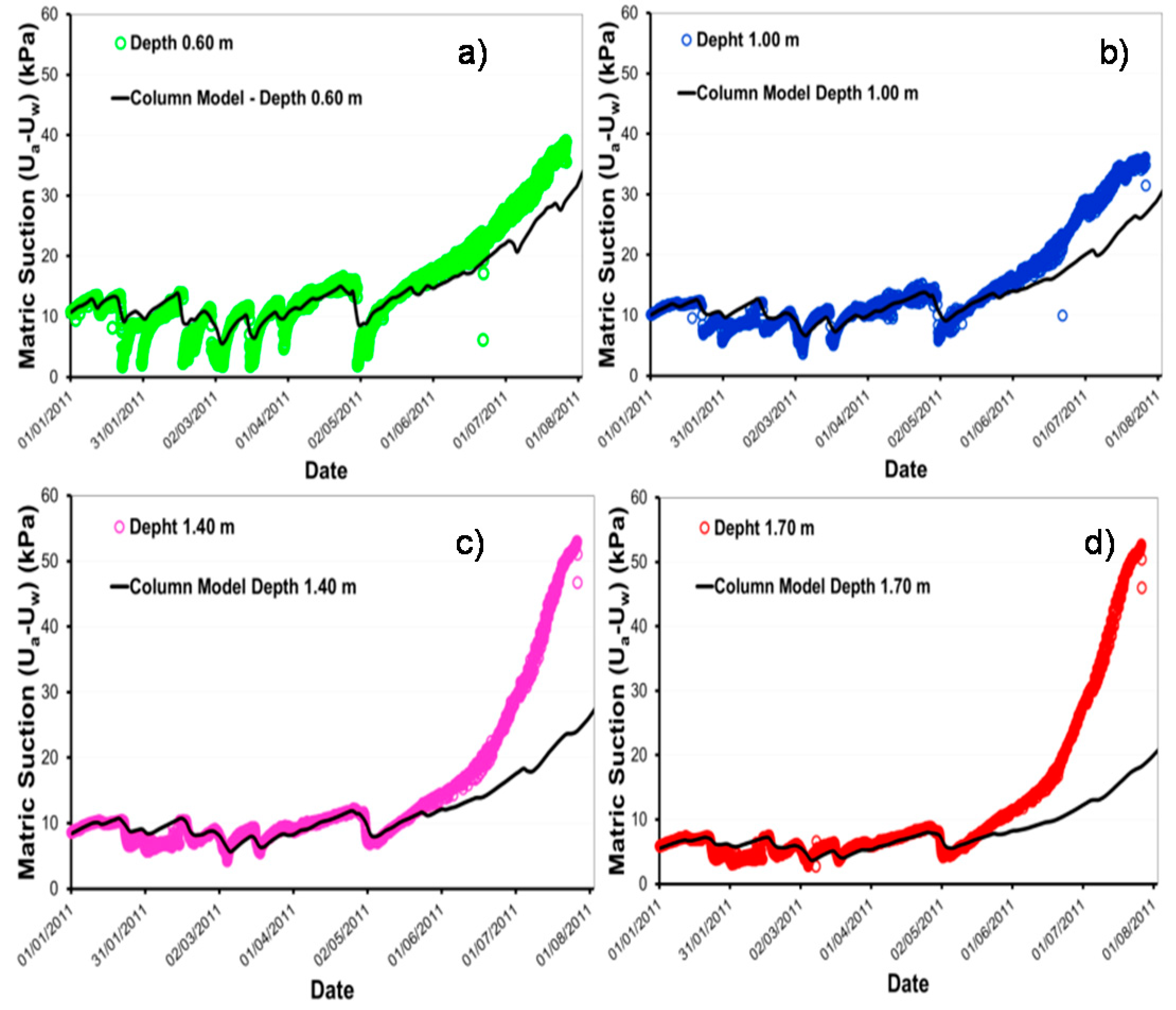
23]. The results are reported in
Figure 11 and
Figure 12 in terms of comparison between the measured and simulated water content (
Figure 11) and suction trends (
Figure 12) at different depths in the Cervinara slope during eight months of measurements which show that the model, calibrated on the basis of the “ingredients” provided, is able to capture slope response. However, simpler models, such as those used by Ahmadi et al. [
43] and by Airò Farulla and Rosone [
44], which do not take into account a fully coupled hydromechanical approach, were also able to follow slope response to meteorological input, showing that, in the presence of good quality data, reliable predictions are possible.
7. Conclusions
The occurrence of rainfall-induced catastrophic flowslides, as well as false alarms related to such events, produces technology and productivity shocks, reflected in the value of future and current investments in areas at risk. All the elements defined in this paper in a new type of soil database for hydrogeotechnical models will allow improvements in existing EWSs. Taking into account the nature of pyroclastic soils and the effects of partial saturation conditions on shear strength will improve the ability to predict slope response to rainwater infiltration and, hence, the predictive capability of EWSs, conferring a clear-cut and long-lasting benefit in terms of reducing the risk of false or late alarms.
