Article

The Glacial Geomorphology of the Ice Cap Piedmont Lobe Landsystem of East Mýrdalsjökull, Iceland

1
Department of Geography, Durham University, South Road, Durham DH1 3LE, UK
2
Institute of Geoecology and Geoinformation, Adam Mickiewicz University, Poznan 61712, Poland
3
Department of Geography, Loughborough University, Loughborough, Leicestershire LE11 3TU, UK
*
Author to whom correspondence should be addressed.
Geosciences 2018, 8(6), 194; https://doi.org/10.3390/geosciences8060194
Submission received: 3 May 2018 / Revised: 24 May 2018 / Accepted: 28 May 2018 / Published: 30 May 2018
(This article belongs to the Special Issue Glacial and Geomorphological Cartography)

Abstract

:
A surficial geology and geomorphology map of the forelands of the Sandfellsjökull and Oldufellsjökull piedmont lobes of the east Mýrdalsjökull ice cap is used to characterise the historical and modern landscape imprint in a glacial landsystems context. This serves as a modern analogue for palaeoglaciological reconstructions of ice cap systems that operated outlet lobes of contrasting dynamics, but the subtle variability in process-form regimes is encoded in the geomorphology. The landsystems of the two piedmont lobes reflect significantly different process-form regimes, and hence contrasting historical glacier dynamics, despite the fact that they are nourished by the same ice cap. The Sandfellsjökull landsystem displays the diagnostic criteria for active temperate glacier operation, including arcuate assemblages of inset minor push moraines and associated flutings, kame terrace and ice-dammed lake deposits, linear sandar directed by overridden moraine arcs, and since 1945, features, such as ice-cored, pitted, and glacially pushed outwash fans that are linked to englacial esker networks representative of recession into an overdeepening. Moraine plan forms have also changed from weakly crenulated and discontinuous curvilinear ridges to sawtooth features and crevasse-squeeze ridges and till eskers in response to changing proglacial drainage conditions. The Oldufellsjökull landsystem displays subtle signatures of jökulhlaup-driven surges, including sparse and widely spaced moraine clusters that are separated by exceptionally long flutings. The subtlety of the surge imprint at Oldufellsjökull was recognised only by comparison with nearby Sandfellsjökull, suggesting that palaeo-surging has likely been under-estimated in the ancient landform record. Hence, the simple imprint of sparse and widely spaced moraine clusters that are separated by exceptionally long flutings should be included as possible surge-diagnostic criteria.

1. Introduction

Mapping sediment-landform associations on modern glacier forelands facilitates a better understanding of the nature of spatial and temporal change in glacial process-form regimes. As a result, the increasingly diverse family of glacial landsystem models arising from such mapping is contributing to better informed palaeoglaciological reconstruction that is guided by suitable modern analogues. Although a variety of glacierization styles has been collated from the historically deglaciated forelands of Iceland [1,2,3,4,5,6,7,8,9,10,11,12,13,14,15,16,17,18,19,20], important subtleties in the imprints of glacial process-form regimes still remain to be elucidated.
We present the first surficial geology and geomorphology map of the forelands of the Sandfellsjökull and Oldufellsjökull piedmont lobes of the east Mýrdalsjökull ice cap (Figure 1) in order to characterise their Little Ice Age (LIA) and recent landscape imprint, and to use that imprint in a landsystems context in order to assess their dynamics in response to historical climate patterns. Although the snouts of Oldufellsjökul [21] and Kötlujökull [22] have previously been associated with surging activity, at least since the 1950s, the snout of Sandfellsjökull, which lies between these two glaciers and is nourished by the same ice cap, has been classified as an active temperate system based upon its densely spaced (largely annual) push moraines by Evans et al., (1999) [23]. The glacial landsystems of Sandfellsjökull and Oldufellsjökull, as presented by the new mapping reported here, constitute important modern analogues for employment in palaeoglaciological reconstructions of ice cap systems that operated outlet lobes of contrasting dynamics. Intensive analysis of such landsystems in situations where form can be confidently linked to process is critical to the identification of spatial and temporal variability and the superimposition [24] of glacier dynamics when they are encoded in the ancient geomorphology of glacierized terrains, especially when such information is manifested as only subtle signatures.

2. Methods

Mapping was undertaken on an aerial orthophotograph processed from 51 aerial photographs that were taken on 6 August 2007 in three lines (3 × 17) at an altitude of 2865 m (9400 ft) and 3109 m (10,200 ft) and using an analogue RC 10 aerial survey camera and 15 UAG II lens with a focal length of 153.44 mm. Photographs were scanned at 1270 dpi and the location of each photograph was available in metadata. The aerial photographs were photogrammetrically processed to create an orthophotograph mosaic and digital elevation model (DEM), from which contours were derived at 5 m intervals. To ensure accurate processing, 21 ground control points were surveyed using dGPS and marked by highly visible red coloured fabric squares measuring 1 m × 1 m. A total of 15 of these markers that were visible on the aerial photographs were used as ground control points for absolute orientation, with the remaining six points being used as independent checkpoints to assess the accuracy of the processing. The final orthomosaic and digital elevation model have 0.4 m and 1 m cell sizes, respectively. The surficial geology and glacial geomorphology map was designed to be at a scale 1:12,000 when printed at the A0 paper width of 84 cm, which will result in a print-out length of 105 cm (see Supplementary Information for large format version designed for downloading and printing).
The surficial geology and landform classifications that were used in map compilation and presented below are based upon a combination of aerial photograph mapping and field-based observations. A field expedition was undertaken for ground-truthing the aerial photograph mapping in 2007, at the same time that ground survey control stations were established. Research on the landforms and sediments and lichenometric dating in the area was undertaken also in 1994 and 2009, and it is reported by Evans et al., [25,26].

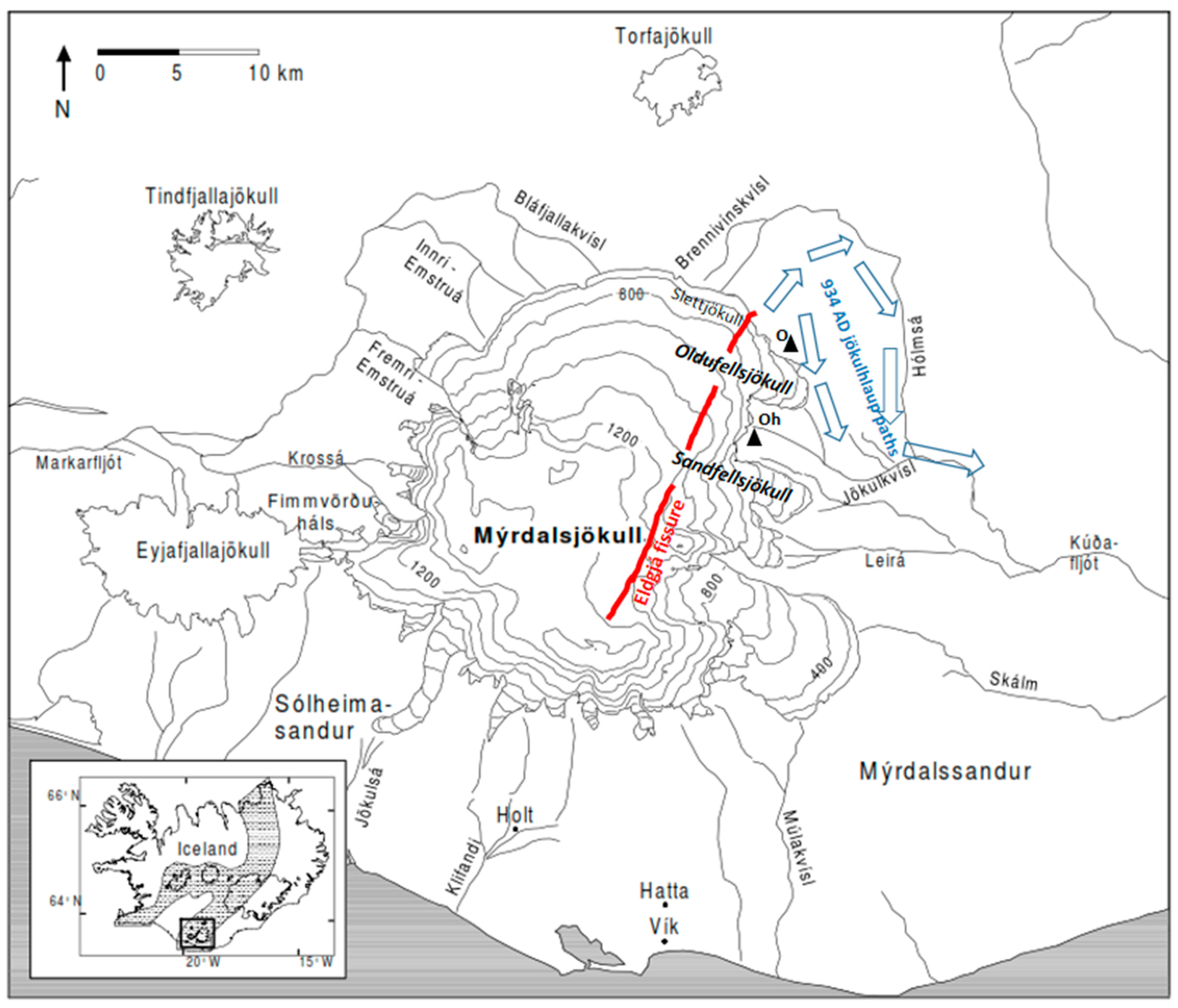
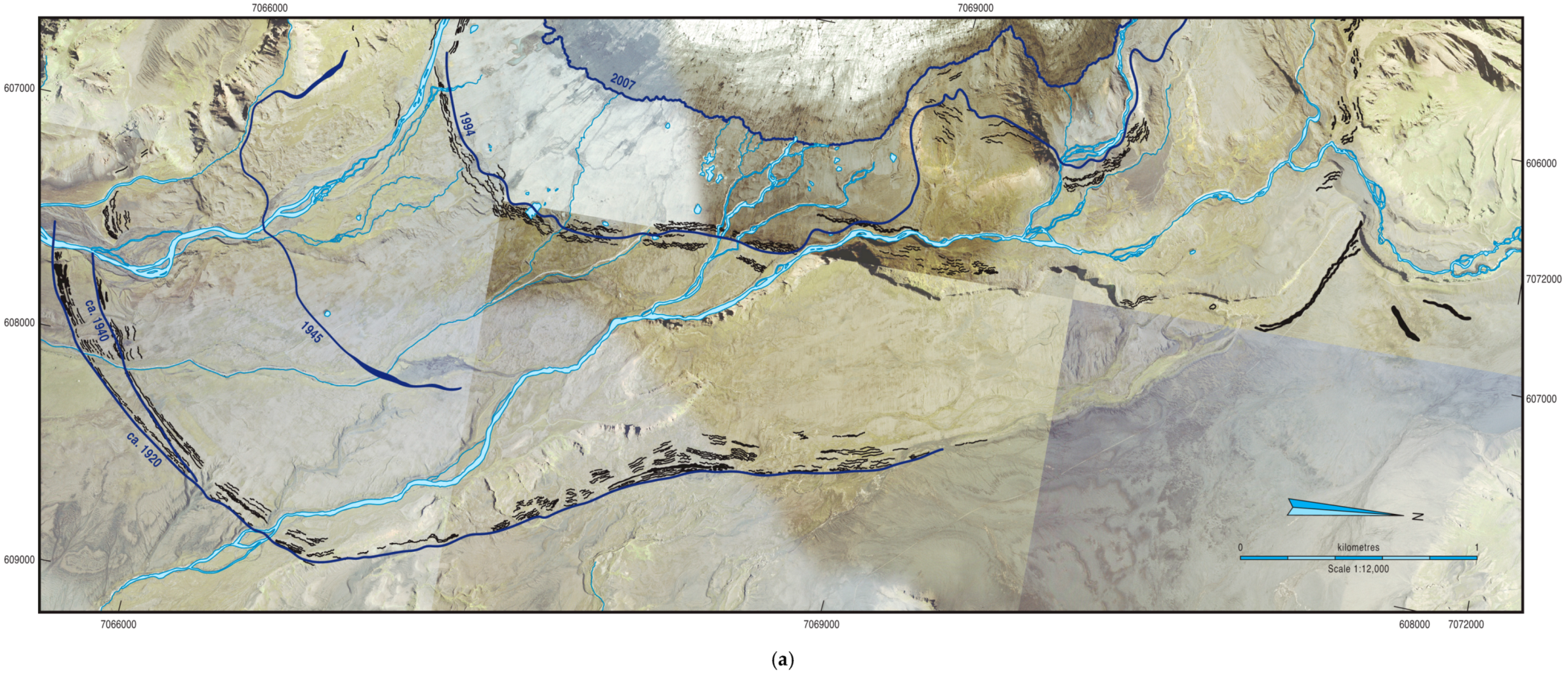
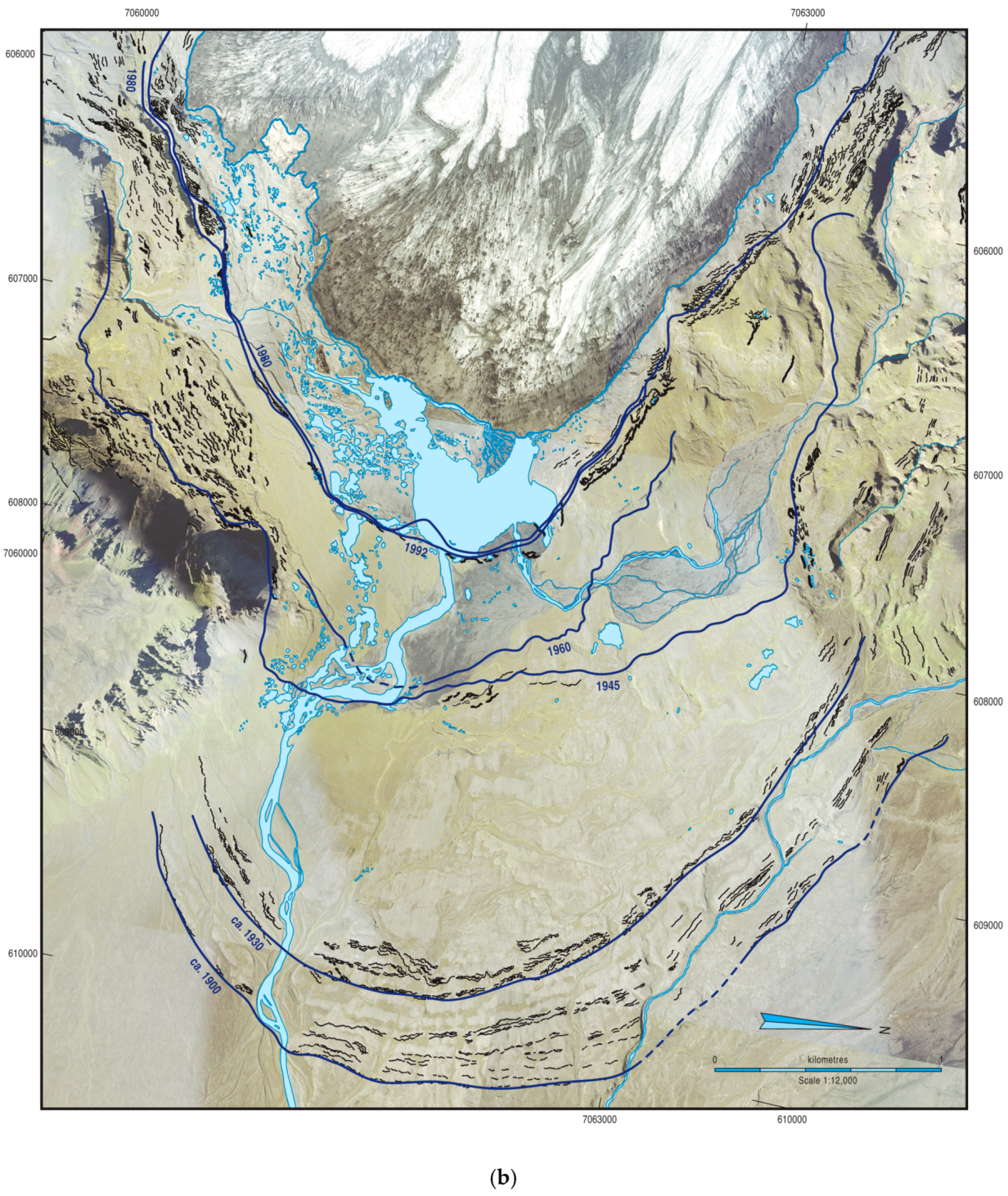
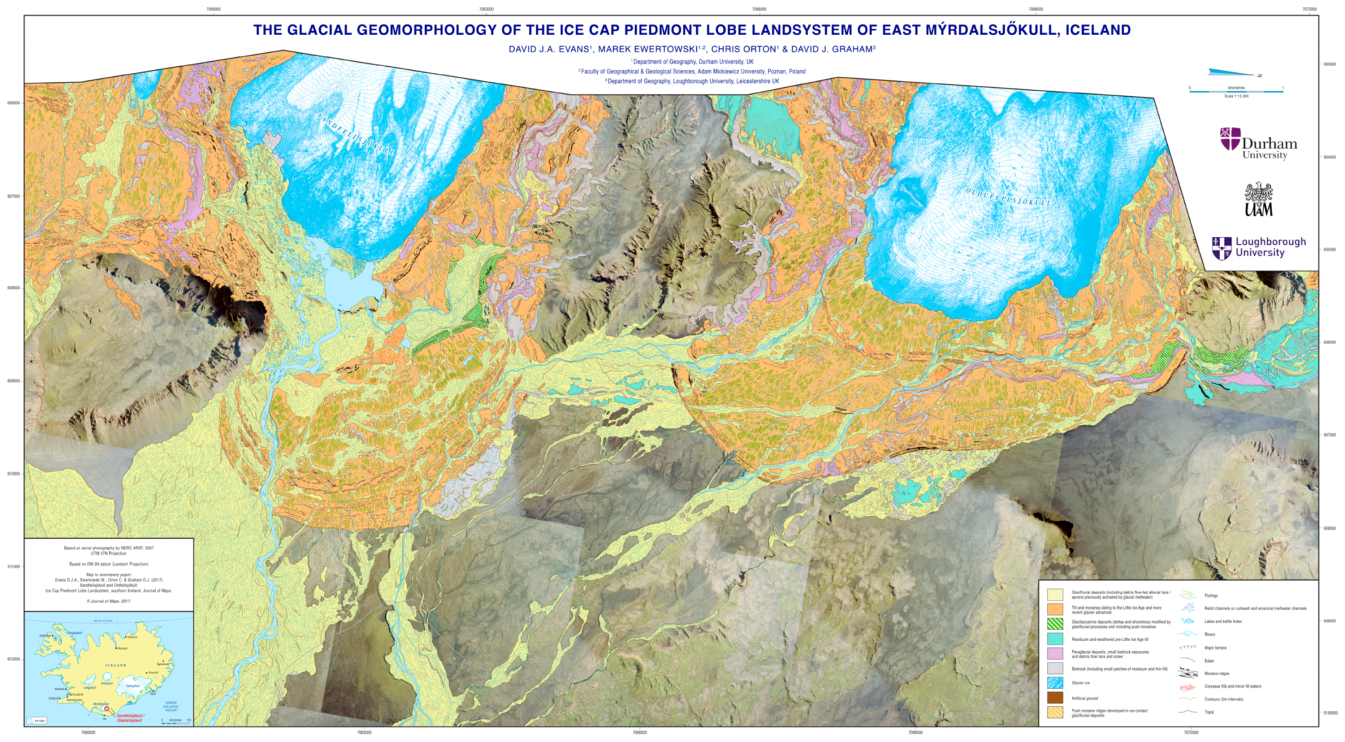
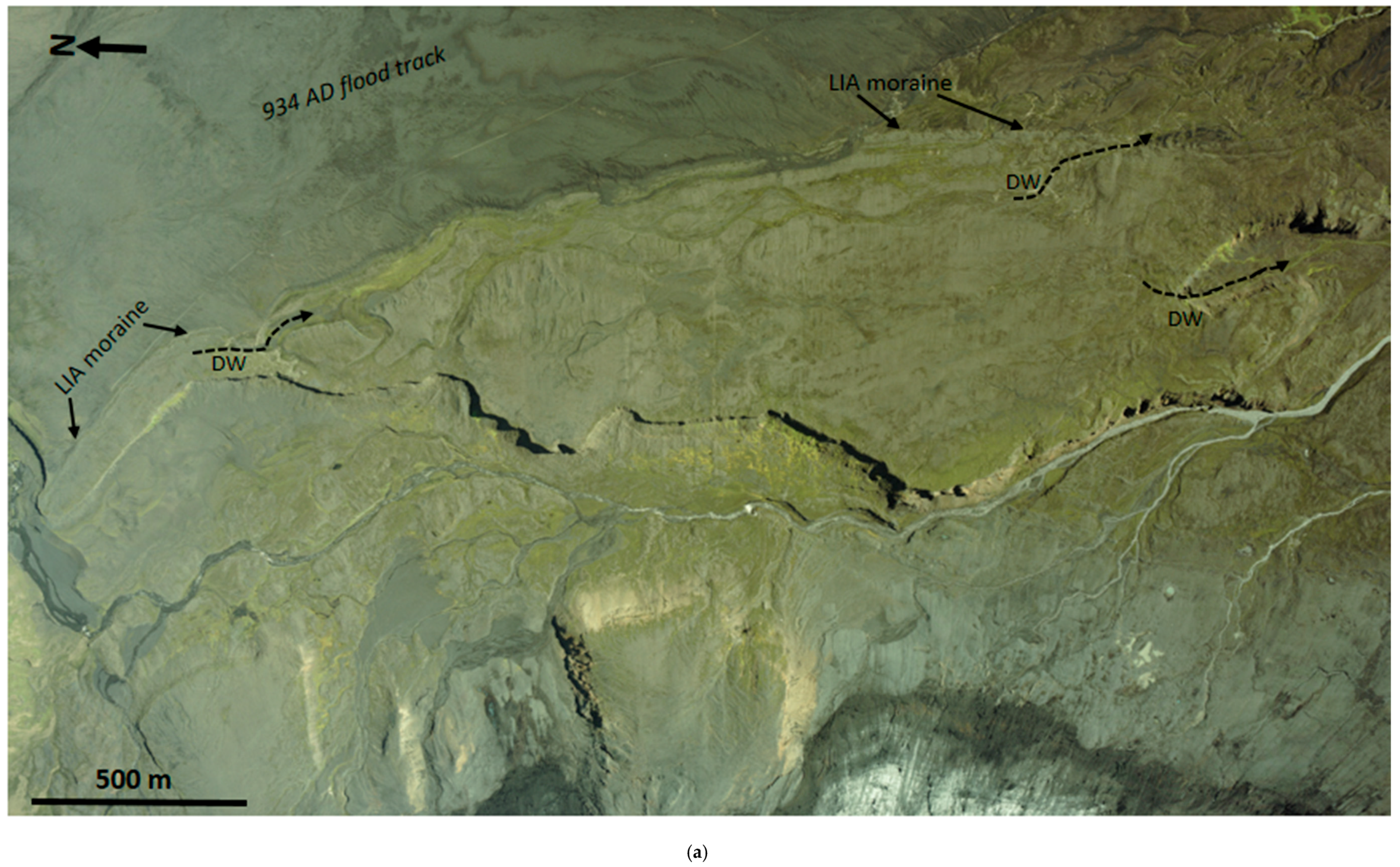
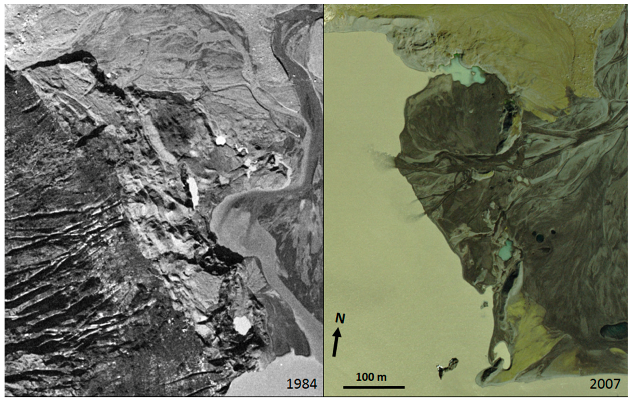
3. The Sandfellsjökull and Oldufellsjökull Piedmont Lobes

Relative to other glacier outlets in Iceland, the east Mýrdalsjökull piedmont lobes of Sandfellsjökull and Oldufellsjökull have been the subject of only limited study (Figure 1). Moreover, only Oldufellsjökull has been monitored for ice-marginal oscillations and only for the short period since 1960 (Figure 2). Both of the lobes descend from the eastern rim of the Katla caldera [27,28], nourished by radial ice flow from the Mýrdalsjökull ice cap, the fourth largest glacier in Iceland, and flow through glacially eroded incisions in the caldera rim. Importantly, with respect to potential controls on ice dynamics, the volcano is one of the most seismically active in Iceland and its interaction with the ice cap have resulted in huge jökulhlaups [22,29,30,31,32,33,34,35,36,37]. From the ice cap summit plateau at 1300 m, the surface of Oldufellsjökull descends over a distance of 15 km down to 380 m, and Sandfellsjökull down to 230 m over a distance of 12 km, but their snout surface gradients are similarly steep [38]. The subglacial topography beneath the two lobes, as depicted by Björnsson [38] and Björnsson [39], differs in that Sandfellsjökull traverses a series of caldera rim ridges immediately below the ice cap plateau before descending into a narrow and relatively shallow overdeepening that has hosted proglacial lakes at various stages of snout recession. In contrast, Oldufellsjökull flows onto a low gradient, southerly dipping bedrock slope bordered to the east by a 50 m high cliff that was overrun by the left lateral margin of the snout during the LIA maximum [38]. Although a small enclosed bedrock depression appears to lie beneath the present snout, the bedrock surface rises steeply at around 2.5 km up-ice of the Oldufellsjökull margin to a col, which connects the mountains of Oldufell and Olafshaus (Figure 1) subglacially, before descending into a large, N-S orientated subglacial depression. This depression is linked to a southwesterly-trending narrow subglacial valley that extends up to the caldera margin, and hence topographically constrains ice flow from the ice cap summit to the northern outlet of Slettjökull/Merkurjökull; consequently, Oldufellsjökull persists as a piedmont lobe only because ice thicknesses at present are sufficient to feed the flow of the glacier eastwards over the col. It therefore forms only a small part of the total ice northern catchment of 171 km2, and hence it is not significantly greater in size than that of Sandfellsjökull at 66 km2 [38].
Previous research around the eastern and northern margins of the Mýrdalsjökull ice cap has identified that Kötlujökull (Hofðabrekkujökull) in the south constructs moraines on an infrequent basis (i.e., non-annual; [1,40]), which in at least one case was likely in response to surging activity [22]. Substantial glacitectonic thrust and dump moraines were created during a relatively long period of stabilization and ice front steepening between 1979–1984, when the snout advanced 10–32 m per year and it overran its 1960 limit in the north and east and its 1945 limit in the south [41,42,43,44]. Additionally, large volumes and expansive spreads of supraglacial debris, which were derived from debris-rich basal ice facies [1,40,45], have given rise to the development of significant areas of hummocky moraine on the Kötlujökull foreland [1,40], as well as supraglacially-fed Hochsandur fans [1,46,47]. In contrast, Slettjökull in the north is characterized by active temperate conditions with intense winter freeze-on events [1,48,49,50]. The geomorphological implications of these contrasting behaviours are that Kötlujökull tends to construct large, composite thrust moraines inset with hummocky moraine but the Slettjökull and Merkurjökull forelands are characterised by densely spaced, recessional push moraines that are overprinted to form composite push moraines during periods of ice margin stabilization.
The historical and modern dynamics of Sandfellsjökull and Oldufellsjökull are largely unknown, with the exception of the post 1960 record of snout oscillations at Oldufellsjökull (Figure 2). This record shows that, like other monitored snouts in the region, Oldufellsjökull has been in rapid recession since the late 1990s. However, unlike the other snouts it underwent two significant re-advances in 1974 and 1984 after 5–7 year periods of marked recession. Like other glaciers both in this region and elsewhere in southern Iceland the snout also underwent a re-advance in the early 1990s (~1992; [21]). These oscillations contrast markedly with the gradual single re-advance trends of adjacent glaciers from 1970 to the mid-1990s and have been related to surges by Björnsson [21]. The locations of the margins of Sandfellsjökull and Oldufellsjökull have been collated on Figure 3 using historical aerial photographs that were taken as far back as 1945 and beyond that by adopting the lichenometric dates that were proposed by Evans et al. [25]. Comparisons of the marginal positions indicate that both of the snouts appear to have retreated quickly immediately prior to 1945 after a period of slow recession and closely spaced push moraine formation dating to around 1900–1930s at Sandfellsjökull and around 1920–1930s at Oldufellsjökull. A further densely-spaced arc of push moraines dating to the 1980–1990s at both glacier snouts documents their oscillations at that time. This is well captured on aerial photographs, especially at Oldufellsjökull (Figure 4), on which snout downwasting is captured in 1978 and 1980, and steepening and intensive crevassing and the overriding of moraines is captured at the peak of the 1984/85 re-advance (surge); the following, less extensive mid-1990s re-advance (surge) and moraine construction is then captured on the 1994 photography. At Sandfellsjökull, the very close coincidence of the glacier margin on the 1980 and 1992 aerial photography indicates that it was also relatively stable towards the end of the 20th century, but since that time, the development of a large proglacial lake and collapsing ice-cored outwash has been influential in its rapid thinning (Figure 5).

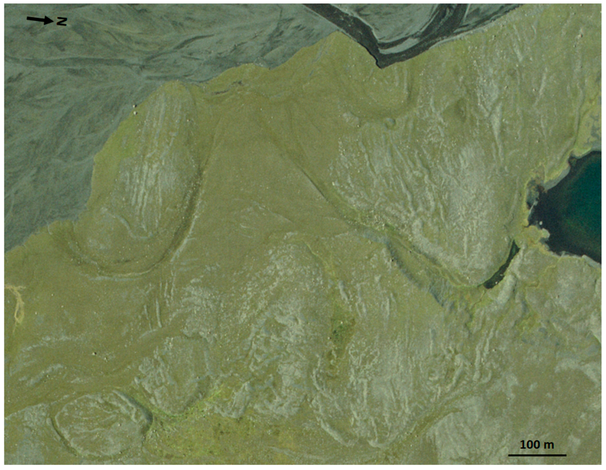
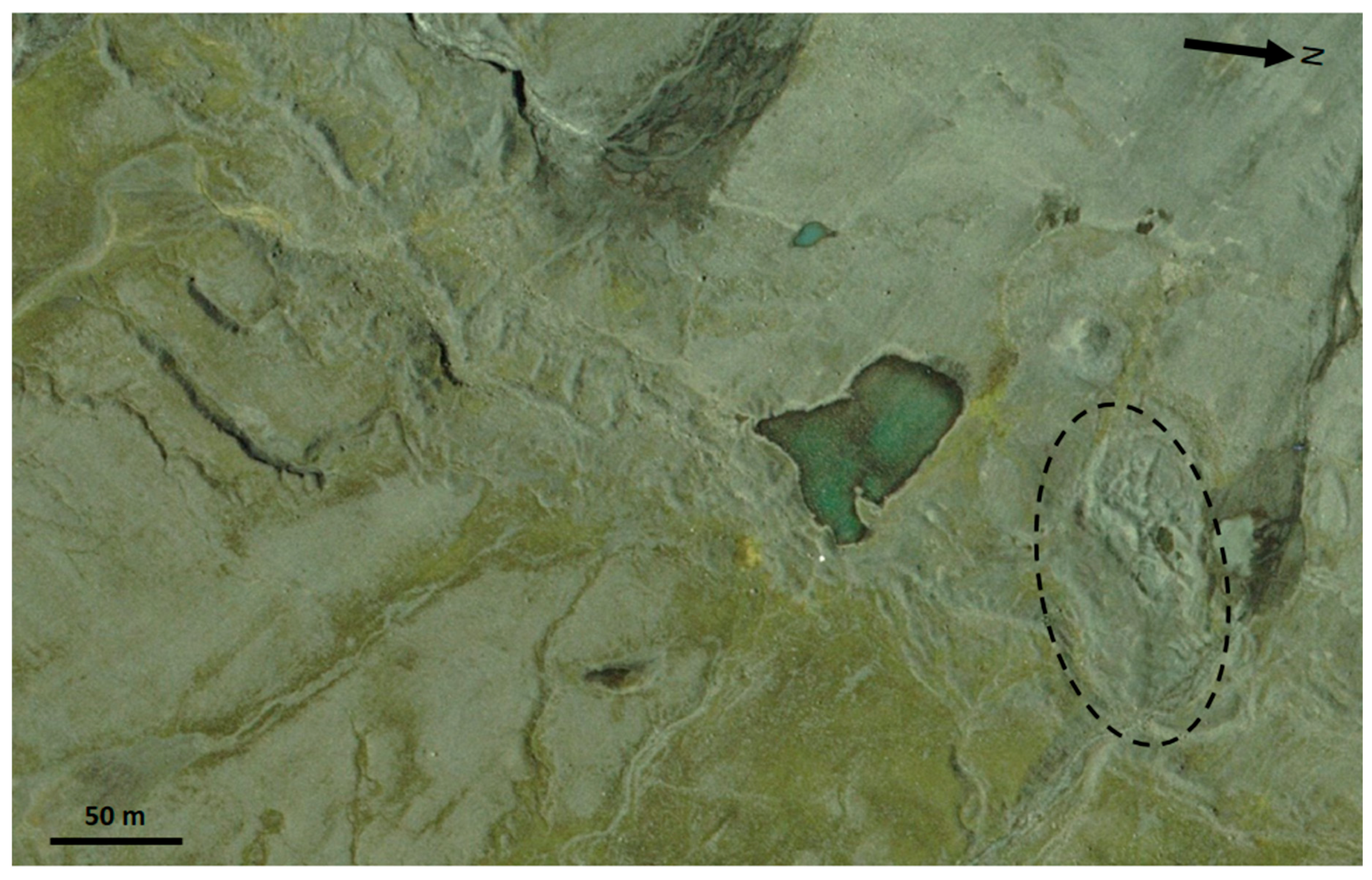
4. Glacial Geomorphology and Surficial Geology of the Glacier Forelands

The surficial geology and geomorphology map (Figure 6) reveals that the glacier forelands are characterized by only four sediment-landform units, including: till and moraines that were deposited during and since the historical (most recent) LIA Type Period (sensu [51,52]); glacifluvial deposits; push moraines developed in ice-contact glacifluvial deposits; and, glacilacustrine deposits modified by glacifluvial processes. Within the limits of the LIA maximum, further areas of paraglacial deposits, residuum and bedrock, all with patches of older glacigenic materials (tills), are identified. Beyond the LlA maximum, only areas of proglacial outwash are mapped, outside of which the land surface is represented by the underlying orthophotograph. A significant surface deposit in this area is the product of the 934 AD jökulhlaup that emerged from beneath Slettjökull/Botnjökull and Oldufellsjökull in response to an eruption in the Eldgjá fissure beneath the northeastern Mýrdalsjökull ice cap ([37]; Figure 1). Immediately beyond the LIA maximum limit on the eastern edge of the Oldufellsjökull foreland these deposits display remarkable giant gravel bars, which formed the bed of one of the main discharge routes between Mælifellsandur in the north and the Jökulkvisl/Hólmsá network in the east (Figure 1).

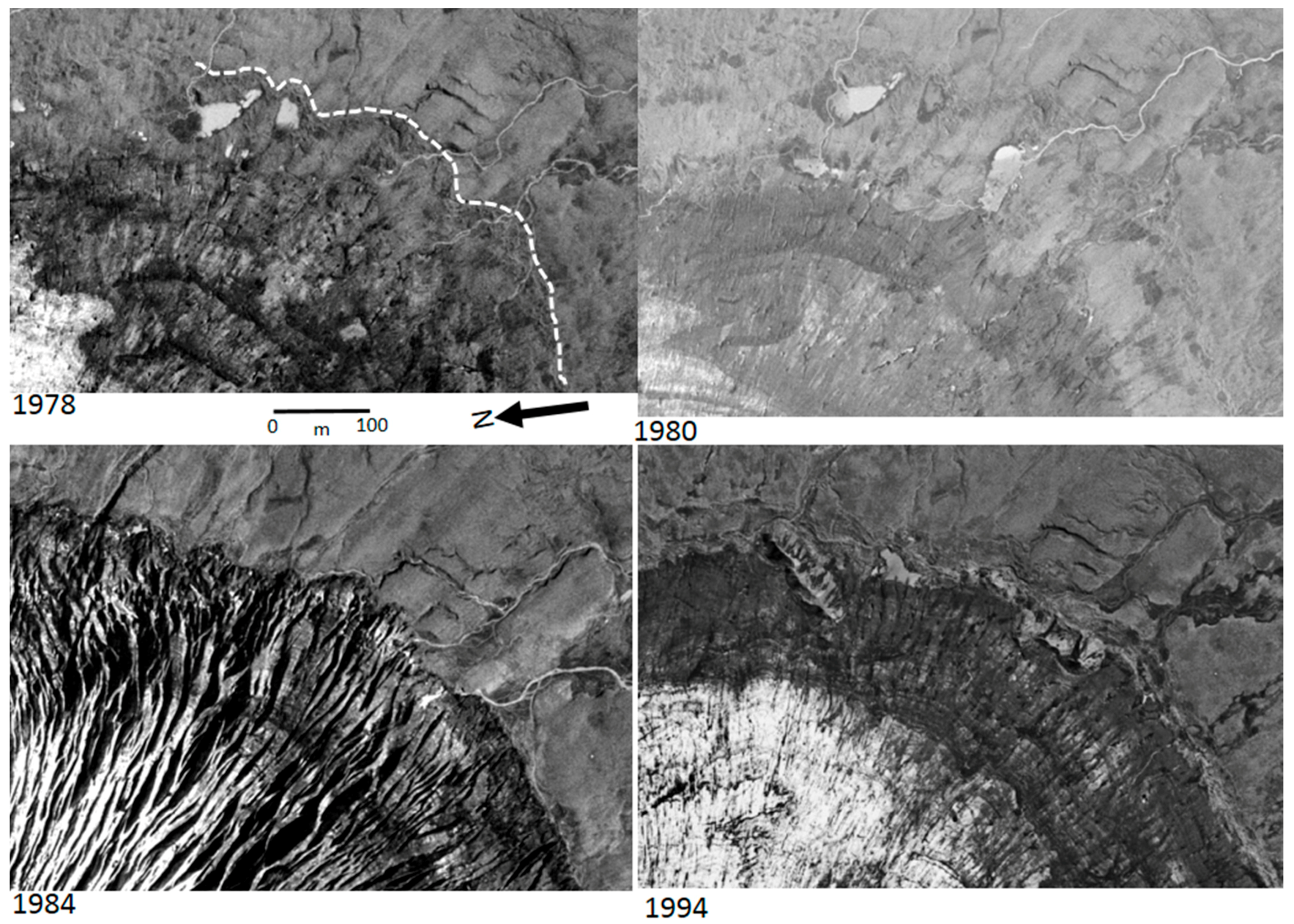
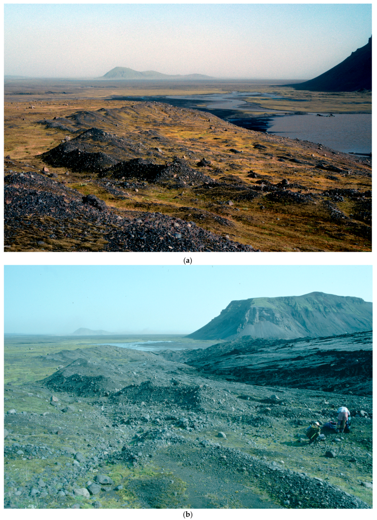
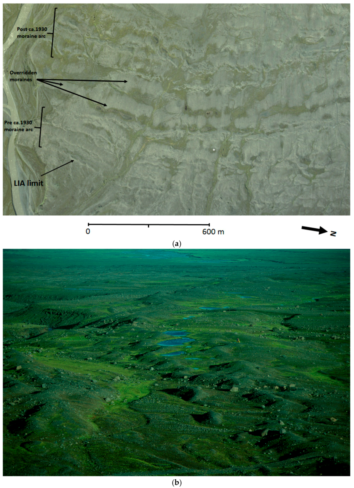
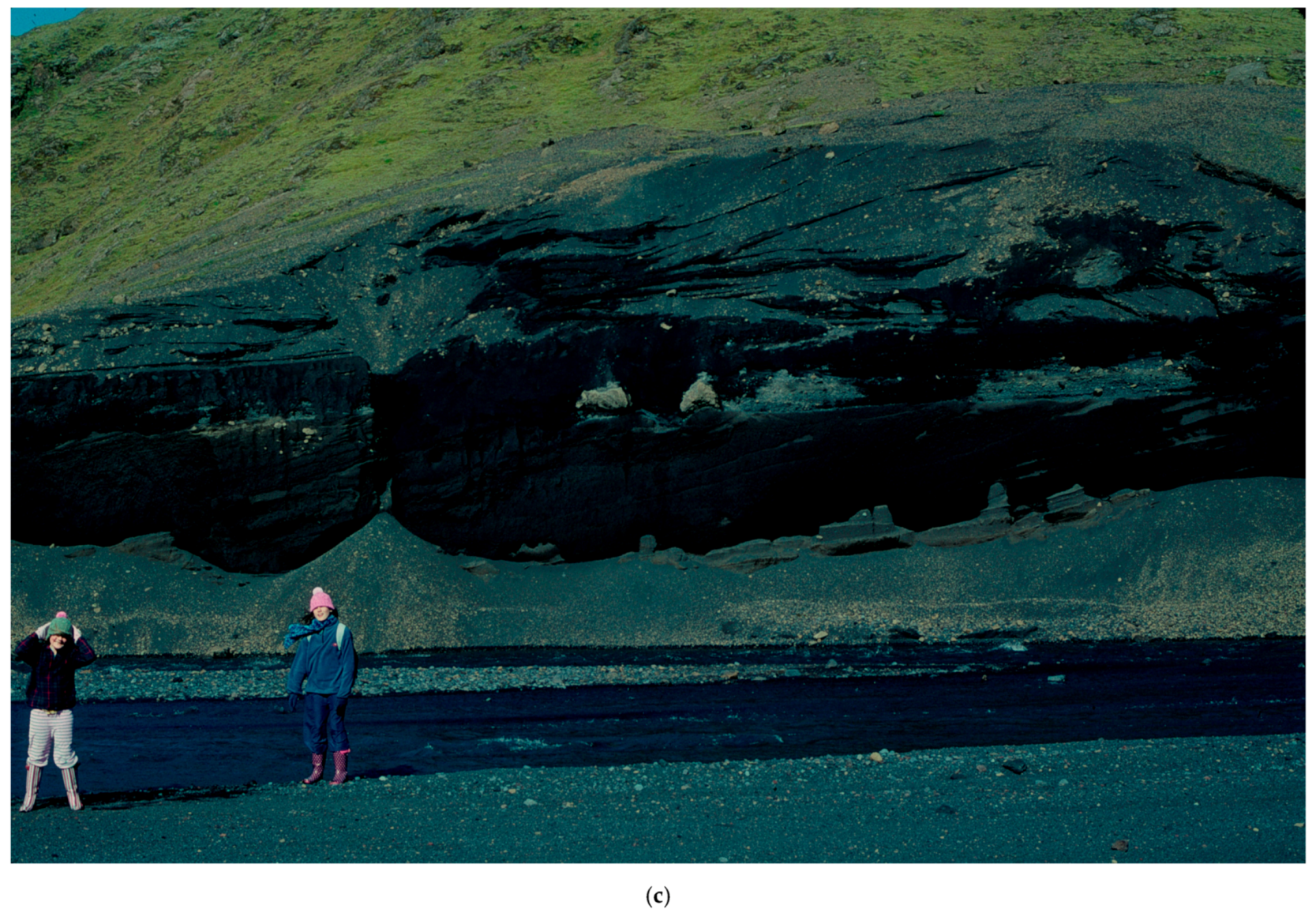
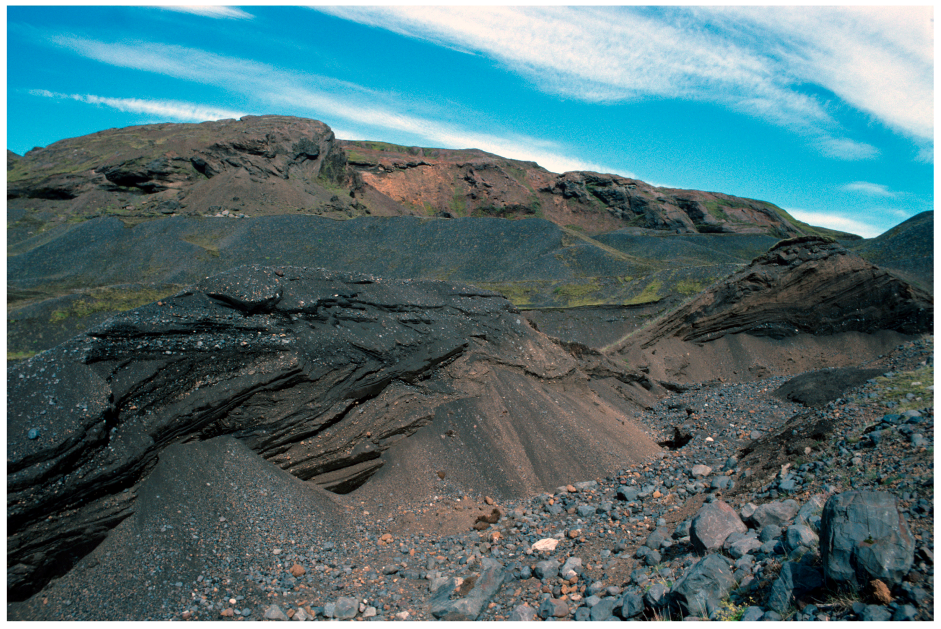
4.1. Till and Moraines

The extent of the historical LIA glacier coverage on both forelands is demarcated by fluted till surfaces and minor push moraines (Figure 6), some of which are closely-spaced but are not substantially overprinted to form push moraine complexes ([48,50,53]; Figure 7). Broad arcuate ridges superimposed by the minor push moraines and flutings (Figure 7a,c) have been interpreted by Evans et al. [23] as overridden moraines, features that have been recognized widely on recently deglaciated forelands in Iceland and related to events that predate the historical LIA maximum [1,3,6,9,12,19]. Moraine plan forms vary from weakly crenulated and discontinuous curvilinear ridges to more voluminous and continuous sawtooth features, with the latter being more prevalent in the inner foreland of Sandfellsjökull and postdating ca.1945 (Figure 3b and Figure 5).
Push moraine spacing patterns on the two forelands display some similarity, and, as outlined above, can be equated to distinct periods of snout oscillations. The outermost push moraines on both forelands are closely spaced, especially at Oldufellsjökull, where the snout appears to have been relatively stable over the 1920s–1930s and produced two to three sets comprising multiple subsidiary moraines with individual crests that are often partially superimposed on one another (Figure 3a, Figure 6, and Figure 7c). At Sandfellsjökull, there is a similar grouping of two sets of recessional push moraines, with the outer set of up to 11 individuals dating from around 1900–1930 and spaced 10–50 m apart, and the inner set of up to 13 individuals dating to the 1930s and being <10 m apart and often partially superimposed (Figure 7a,b). The lichenometric dating of Evans et al. [25] indicates that the two outer moraine belts at both glaciers likely date to the early 20th century (Figure 3). The closer moraine spacing at Oldufellsjökull, but more particularly the occurrence of two to three major ridges, indicates a relatively more stable snout at that time, but could also be a product of surging activity that was not recorded by historical documentation and is evident in the post-1970s period (Björnsson et al., 2003). The large number of moraine ridges at Sandfellsjökull for the likely time interval is typical of active temperate snout operation and the production of annual push moraines [3,54,55,56,57]. Although exposures are rare, a section through one of the outer Sandfellsjökull moraines revealed poorly-sorted sands and gravels that were contained within distorted lenses and overlain by sand and gravel rich diamictons (Figure 7d), characteristics typical of ice-marginal bulldozing of proglacial glacifluvial deposits [55,58], but not necessarily diagnostic of sub-marginal till slab freeze-on and stacking [48,50,53] or sub-marginal squeezing [59].
The most recent sets of densely-spaced push moraines on both forelands date to the 1980s–1990s and coincide with the early-1990s phase of glacier snout re-advance/stabilization recognized more broadly across southern Iceland (Figure 3, Figure 4, Figure 5 and Figure 6; [6,9,53,55,56,60]). Increased crenulation or sawtooth moraine plan forms appear to have been associated with this phase of snout activity, a characteristic that is strongly linked to the development of till squeezing and bulldozing into ice-marginal pecten, controlled by longitudinal or splaying crevasses [1,9,12,59]. The zonation of moraine patterns in Iceland, specifically the strong relationship between sawtooth moraines and recent (post-1960s) snout recession, has been related to the uncovering of overdeepenings where poor drainage combines with crevassed snouts to produce till squeezing ([9,12]), but this appears to be applicable here only to the Sandfellsjökull foreland (Figure 6). The close spacing of the Oldufellsjökull push moraines around the 1970s–1990s ice marginal positions (Figure 3 and Figure 4) reflect the close temporal spacing of the three surge events dating to 1974, 1984 and ~1992, and thereby could constitute excellent analogues for the evolution of the outermost moraine arcs dating to the ca. 1920s–1940s, although climate-driven snout stability is an equally plausible scenario.
Between the push moraines, the till surfaces are strongly fluted. The most extensive fluted surfaces occur in the large moraine-free areas between the outermost moraine arcs and the 1990s moraines, but everywhere they comprise low amplitude (<0.50 m high) diamicton ridges with scattered surface boulders and occasional stoss boulders (Figure 8). Individual flutings can be very long, with those in the areas of more widely spaced push moraines on the Sandfellsjökull foreland being at least 400 m in length. Such subglacial bedforms are indicative of persistent and relatively fast glacier flow and are inextricably linked to the subglacial deforming layers of Icelandic active temperate glaciers [3,61,62,63,64]. Particularly long flutings (ca. 800 m) on the Oldufellsjökull foreland, because they are uninterrupted by minor push moraines, are almost an order of magnitude longer than those that were observed in non-surge situations [65], and hence they are compatible with a surging glacier snout [5,14,23,66]. The role of freshly plucked bedrock blocks in the development of flutings is well illustrated on the inner foreland of Sandfellsjökull where flutings and angular boulders adorn the surface of a large former cavity infill that lies downflow of a bedrock cliff. Individual boulders form both the initiator/stoss clasts to flutings, as well as ploughing blocks with till prow features that are indicative of the early stages of lodgement (Figure 9).
The fluted till surfaces on the inner foreland of Sandfellsjökull in particular are conspicuous in that they also contain abundant geometric ridge networks and sinuous, ice flow-parallel till ridges (Figure 8 and Figure 10), interpreted by Evans et al., [26] as crevasse squeeze ridges and till eskers, respectively. Crevasse-squeeze ridges occurring in arcuate bands alongside sawtooth push moraines have been related to active temperate ice dynamics, as opposed to surging by Evans et al., [67], who demonstrate that surge-related crevasse squeezing produces more widespread ridge networks that lack push moraines and are juxtaposed with zig-zag eskers.
Unlike Sandfellsjökull, geometric ridge networks are very rare on the Oldufellsjökull foreland, occurring only at one location in the 1980s–1990s moraine belt. This assemblage can be observed to have evolved between the 1984 and 1994 aerial photographs and from a supraglacial infill of a crevasse-controlled re-entrant in the glacier snout, gradually melting out and being lowered onto the substrate (Figure 4 and Figure 11). It is similar in form and evolution to features on the Heinabergsjokull foreland, as reported by Evans and Orton [19] and interpreted by them as a jokulhlaup-fed re-entrant compatible with, but at a smaller scale to the one that was produced by the 1996 Skeiðararhlaup ([68,69,70]). Its emergence between 1984 and 1994 is coincident with the 1984 and ~1992 surges that were proposed by Björnsson et al., [21], which is not incompatible with a jökulhlaup origin.

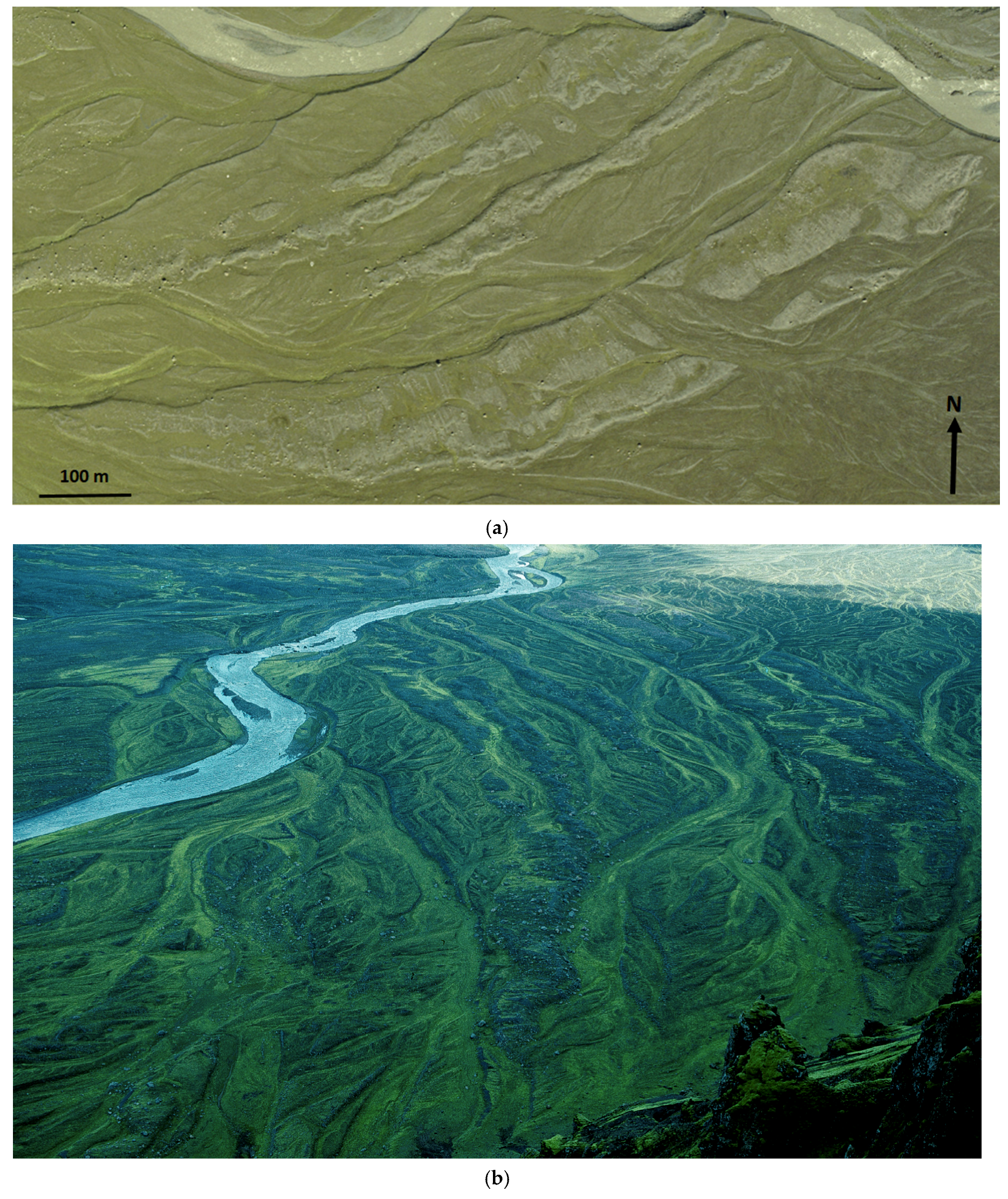
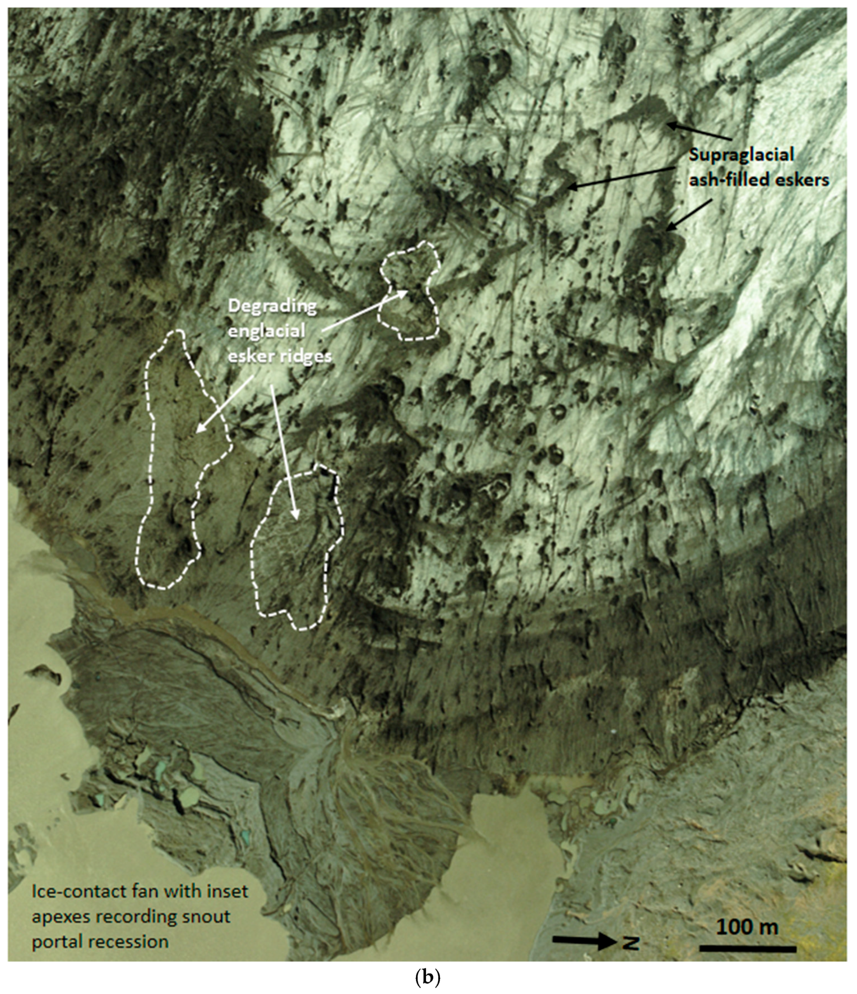
4.2. Glacifluvial Deposits

Although an extensive sandur fan exists beyond the LIA maximum moraine of Sandfellsjökull, glacifluvial deposits are largely contained within narrow ribbons of terraced outwash infilling channels in bedrock or in the lower terrain between arcuate overridden moraine ridges and push moraines. In the latter scenario, the meltwater breaching of low points along moraine crests has resulted in the isolation of elongate “islands” of till and moraine within glacifluvial deposits, best exemplified on the southern half of the Sandfellsjökull foreland (Figure 12). On the Oldufellsjökull foreland, proglacial meltwater streams have been entrenched largely in two bedrock channels, one on the west side of the foreland and the other at the base of a 50 m high bedrock cliff on the eastern side. This cliff was however overrun by the glacier snout during the LIA maximum, forcing the meltwater stream to flow across the higher terrain to the east, locally incising, and reworking the older, 934 AD jökulhlaup deposits; the early stages of ice recession, then resulted in the westward migration of the stream, as recorded by the development of cliff edge incisions, now the locations of dry waterfalls (Figure 13a). Also significant in this pattern of migration of the easterly drainage routes was the development of subglacially engorged eskers at the bedrock cliff base, which is indicative of the plunging of the ice-marginal stream under the ice at various locations during the early stages of downwasting (Figure 13b). Few modern analogues for subglacially engorged eskers have been reported in the glacial research literature since their definition by Mannerfelt [71,72,73]. Significant kame terraces or possible supraglacial deltas were also developed at the northern end of the bedrock cliff once the Oldufellsjökull ice margin had receded from the cliff edge (Figure 13a). These features represent the depo-centre for the glacial meltwater river that flowed toward the ice margin from Slettjökull to the north and was responsible for prograding, and eventually incising and terracing deltas in sequentially lowering lake levels in the valley dammed by the north edge of Oldufellsjökull (Figure 13c). Hence, this series of glacifluvial/glacilacustrine landforms are effectively “inwash” deltas [74,75].
The most substantial glacifluvial landforms have developed around the margins of Sandfellsjökull since 1945. These constitute extensively pitted outwash and kame and kettle topography on the southern part of the foreland, within which chains of elongate ponds have evolved, likely centred over collapsing subglacial/englacial tunnels (Figure 14a). Evidence for englacial tunnels is visible on aerial photographs as eskers emerging on the downwasting glacier surface (Figure 14b). Overridden, pre-LIA outwash is exposed on the far southern part of the foreland, where it is exposed as horizontally bedded gravels and sands capped by a gravelly till veneer and push moraines, and still forms a wide horizontal bench despite being adorned with moraines (Figure 14c). On the north side of the Sandfellsjökull foreland, kame terraces and the shorelines of narrow ice-marginal lakes skirt the lower slopes of a till-covered, glacially streamlined bedrock ridge (Figure 15a,b). Lake waters are evident at this location on the 1945 and 1960 aerial photographs, their early spillways being marked by terraced outwash in the col between the streamlined bedrock ridge and the steep slopes of the mountain ridge to the west (Figure 15a). The decanting lake waters, augmented with marginal meltwater, initially drained around the LIA maximum moraines, and then through the early recessional moraine arcs. This drainage route was abandoned once the glacier snout receded from the streamlined bedrock ridge, causing lake surface lowering and water flow towards the east along the ice margin. Small lake (“inwash”) deltas and kame terrace fragments, which are incised by later river downcutting, also occur in the steep-sided valleys of the upland to the north of the snout (Figure 15c).
Since the 1970s, the margin of Sandfellsjökull has been locally constructing push moraines from the extensive and thick glacifluvial deposits on the foreland (Figure 16). These moraines contain deformed gravels and sands and they lie within areas of pitted outwash. They are particularly well developed in an arc around the eastern edge of the proglacial lake on the 2007 aerial photography, indicating that they are likely being constructed as part of an ice-contact outwash head, similar to that reported by Evans and Orton [19] from the foreland of Heinabergsjökull. The extensive collapse and pitting that is evident in these push moraines, based upon comparisons between aerial photographs (Figure 16), clearly indicates that the ridges are locally constructed from supraglacial outwash fans (Figure 14b). Multiple sub-parallel, linear ridges visible on the 1984 imagery in Figure 16 reveal that glacifluvial materials and underlying ice were being proglacially thrust and were stacked to produce a small scale composite ridge type moraine.

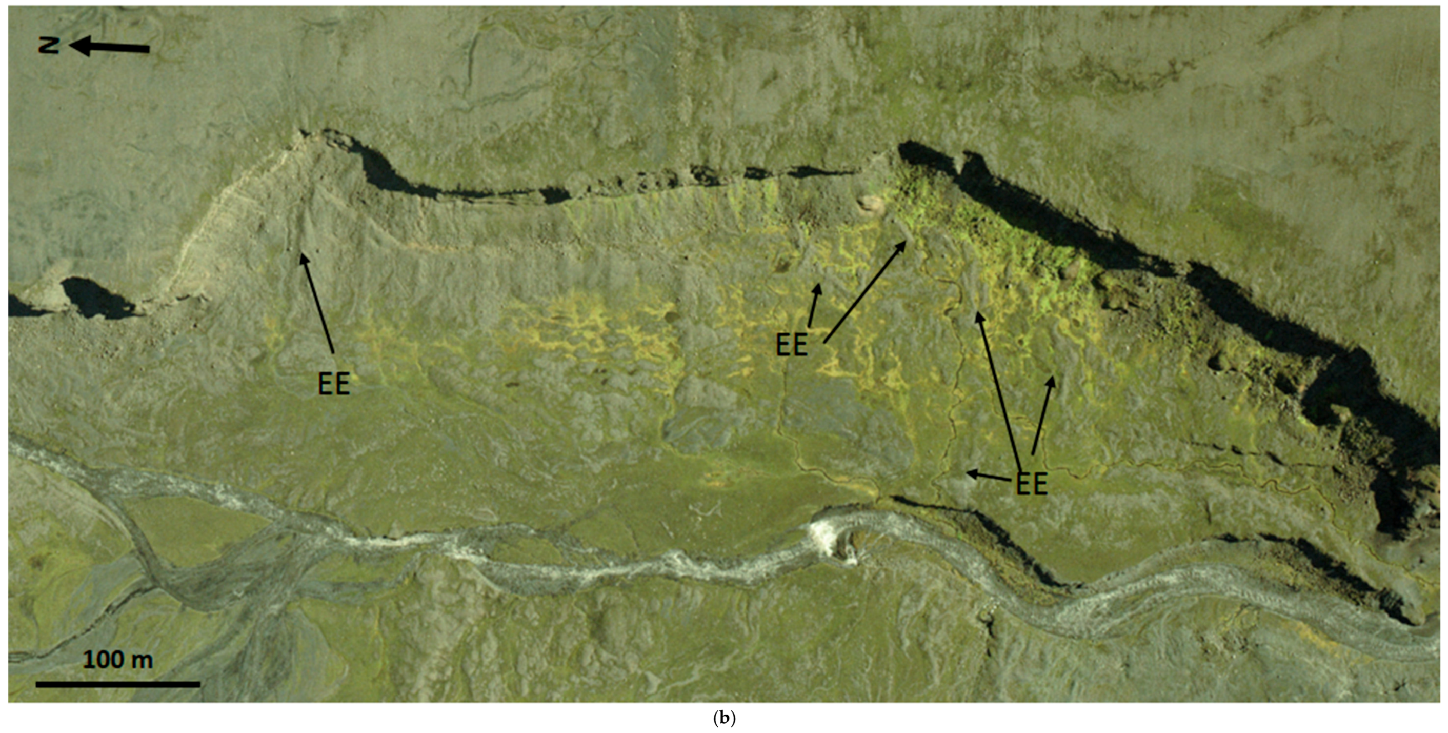
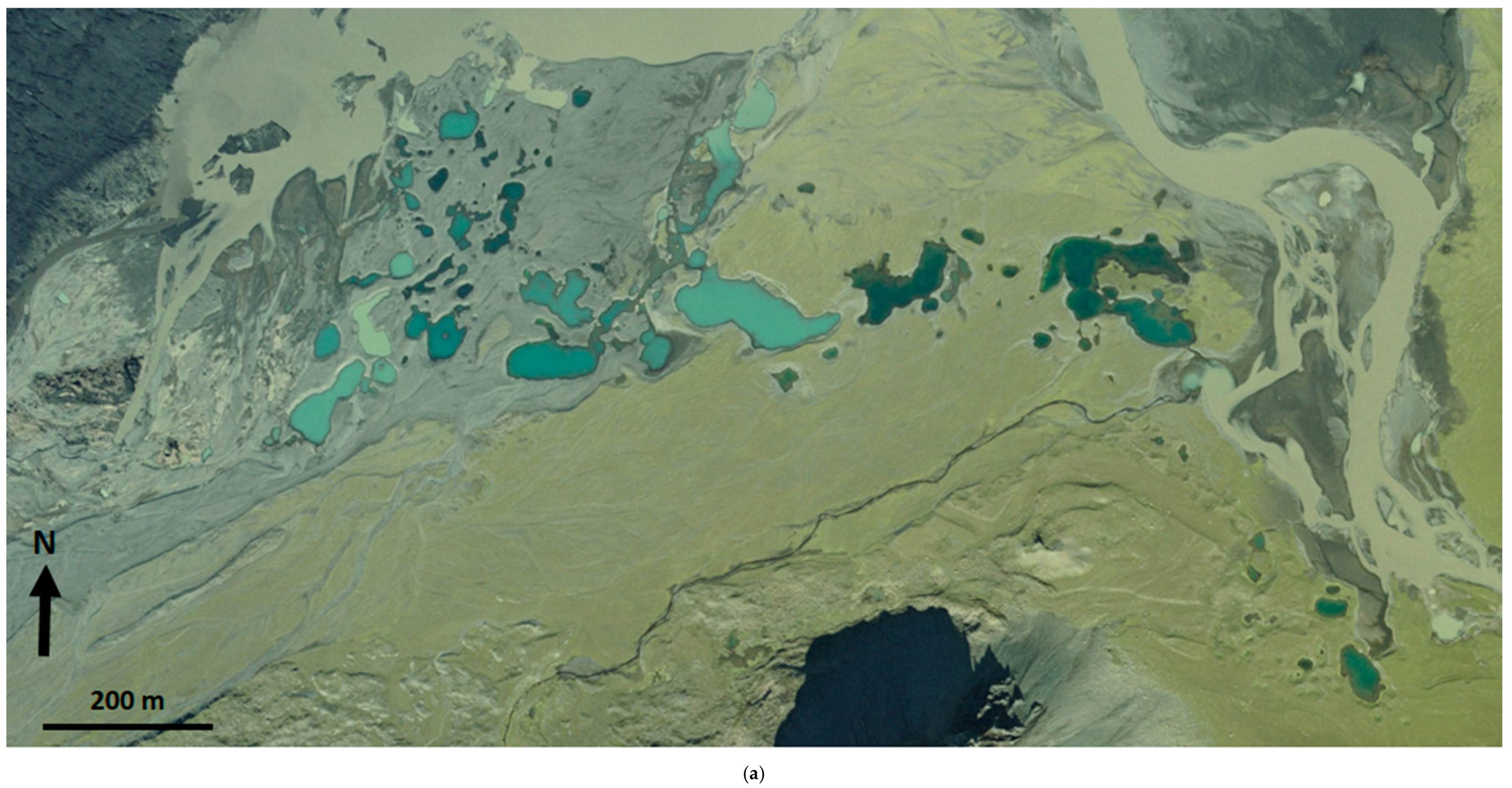
4.3. Glacilacustrine Deposits Modified by Glacifluvial Processes

The complex and often pitted staircases of glacifluvial deposits along the inner northern part of the Sandfellsjökull foreland (Figure 15a,b) contain abundant evidence of localized glacilacustrine sedimentation. Horizontal benches developed in the till and glacifluvial deposits of the fluted upland in this area (Figure 15a) represent the former shorelines of linear proglacial lakes that were dammed between the upland and the receding glacier margin. Such lakes were captured on aerial photographs taken in 1945 and 1960 and local outcrops in the more substantial benches clearly display the foreset bedded gravels and sands typical of deltaic sedimentation (Figure 17). The tops of these deltaic deposits are predominantly truncated and overlain by glacifluvial outwash, indicating that glacilacustrine deposits have been widely modified by glacifluvial processes along the northern part of the Sandfellsjökull foreland. Push moraine ridges also occur in this complex landform-sediment assemblage, which is indicative of localized ice-marginal oscillations coeval with lake formation. The “inwash” deltas in the valley dammed by the north edge of Oldufellsjökull during the early stages of recession from the LIA maximum (see above) are also classified as glacilacustrine deposits that are modified by glacifluvial processes (Figure 13c).

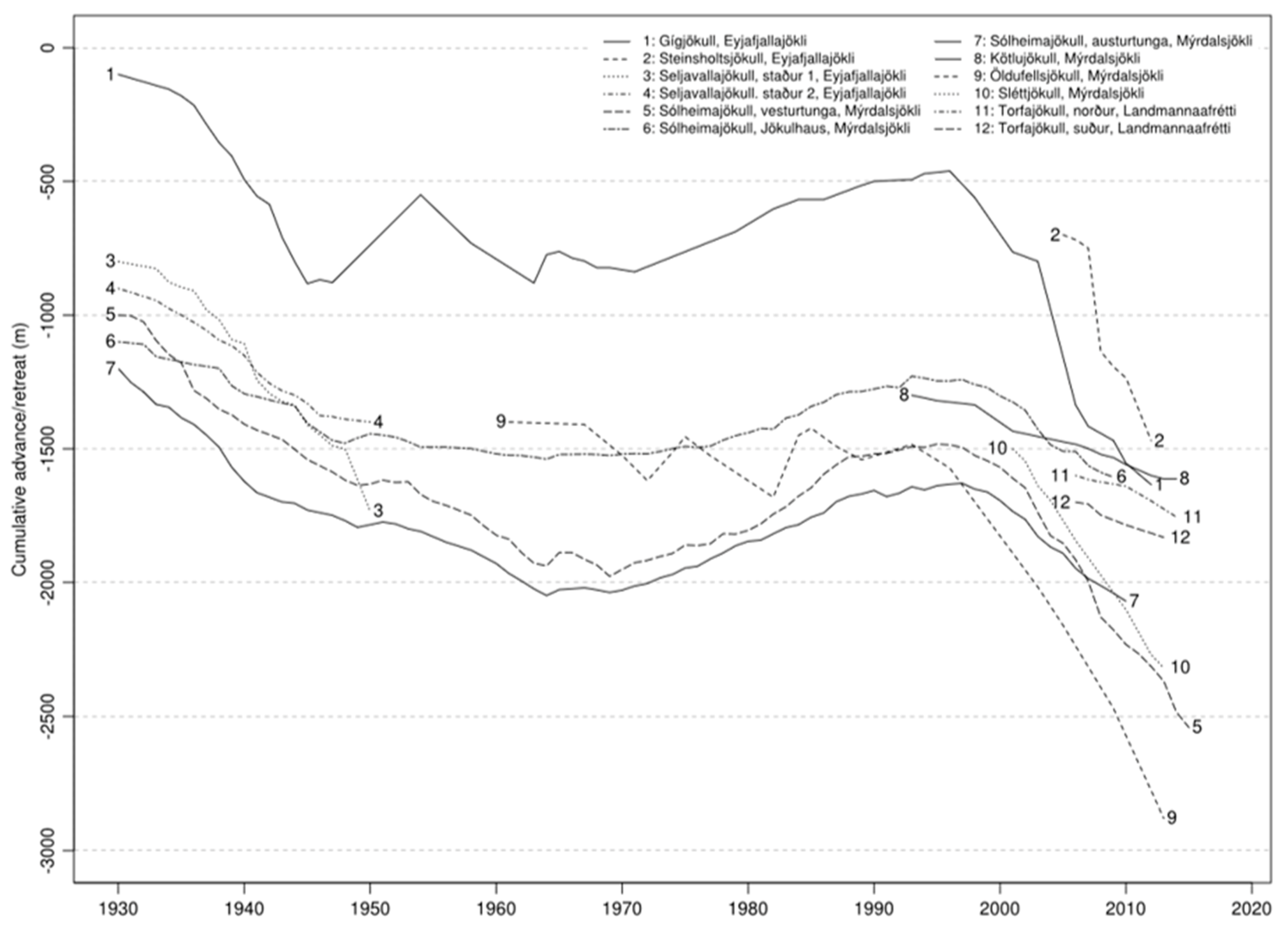
5. Glacial Landsystems and Their Relationships to Glacier Dynamics

The assemblages of glacial landforms and sediments mapped here (Figure 6) represent distinctive and significantly different landsystem signatures for two adjacent piedmont lobes nourished by the same ice cap dispersal centre. This reflects the surging versus non-surging/active temperate behaviour of Oldufellsjökull and Sandfellsjökull, respectively.
The arcuate assemblages of inset minor push moraines and associated flutings on the Sandfellsjökull foreland, in addition to kame terrace and ice-dammed lake deposits and linear sandar directed by overridden moraine arcs, are all diagnostic of the active temperate landsystem, as documented elsewhere in southern Iceland [3,6,9,12,55,56,57,76,77] and more locally at the colder end of the active temperate spectrum at the northeastern margins of Mýrdalsjökull [1,48,49,50]. Recent downwasting by Sandfellsjökull into an overdeepening is evident in the extensive development of ice-cored and increasingly pitted outwash fans (outwash head) and kame and kettle topography, which are linked to englacial esker networks and pushed locally into ridges by continued glacier activity. This is a process-form regime that is becoming increasingly predominant around the rapidly receding active temperate snouts of southern Iceland [15,19,20,78] and is creating a temporal zonation of landsystem development. Also characteristic of that zonation, especially for piedmont lobes, is the change in moraine plan forms, from weakly crenulated and discontinuous curvilinear ridges on the outer foreland to sawtooth features and crevasse-squeeze ridges and till eskers on inner forelands. Elsewhere, this change appears to have been linked to changing drainage conditions on freshly deglaciated forelands, in addition to greater longitudinal or splaying crevasse development. This has been initiated by snout recession into overdeepenings or inside substantial overridden moraine arcs, with both situations creating adverse slopes and hence more restricted proglacial drainage pathways [9,12]. Since 1945 especially, the Sandfellsjökull snout has created substantial numbers of crevasse squeeze ridges and till eskers, but has been more widely buried by proglacial outwash, giving rise to extensive areas of kame and kettle topography and apparent glacier karst development in the form of sinuous kettle holes that are aligned in discontinuous chains, which are representative of collapsed tunnel networks. Englacial eskers feeding ice-cored outwash fans are also indicative of meltwater tunnel networks bypassing an overdeepening [78,79].
Unlike Sandfellsjökull, the landsystem signature of Oldufellsjökull contains less unequivocally diagnostic active temperate characteristics and displays no landforms that are indicative of recent recession into an overdeepening, despite a small bedrock depression having been detected beneath the snout by Björnsson et al., [38]. More specifically different between the two forelands is the moraine spacing. In detail, the outermost moraine assemblage at Oldufellsjökull, comprising two to three major moraines with subsidiary closely spaced or superimposed ridges, is similar morphologically to the cluster of surge moraines dating to the 1970s–1990s, and hence they could also be surge related. Alternatively, their dissimilarity to the two sets of relatively continuous and inset recessional push moraines on the outer Sandfellsjökull foreland, and indeed to the annual recessional moraines at Slettjökull to the north [49], might merely reflect a more stable snout at, and immediately following on from, the LIA maximum. Indeed, the close moraine spacing at Sandfellsjökull and Slettjökull indicates not dissimilarly slow early recession rates. More strikingly different between the forelands is the width of the area containing no moraines, but covered with prominent flutings; at Sandfellsjökull, this appears to represent a temporal gap in prominent moraine formation during the late 1930s–1940s (also apparent at Slettjökull), but at Oldufellsjökull no moraines were constructed from around the 1940s through to the 1974 surge. Additionally, the length of the flutings on this part of the Oldufellsjökull foreland appear to indicate fast and/or sustained glacier flow towards the outer moraine arcs, giving credence to their surge origins. Moreover, since the ~1992 surge, no moraines have been constructed, and again strongly and continuously fluted terrain lies inboard of the surge moraine. The similar ages of the most recent sets of densely-spaced push moraines on both forelands (i.e., 1980s–1990s) do coincide with the early-1990s phase of glacier snout re-advance/stabilization recognized more broadly across southern Iceland, but if this climate signal is inherent within the Oldufellsjökull moraine signature, then it has been overwhelmed by, or assimilated into, the surge signal.
These contrasting characteristics indicate that the glacial landsystems of Oldufellsjökull and Sandfellsjökull reflect different glacier dynamics despite being nourished by the same plateau ice cap. Further afield but still emanating and flowing eastwards from the ice cap dispersal centre, Kotlujökull to the south, and Slettjökull to the north display surge and active temperate landsystem signatures, respectively, although their dynamics are further bespoke in that Kotlujökull’s surges are subtle and manifest predominantly as snout steepening and stability and Slettjökull’s active temperate recession is characterized by intense winter freeze-on episodes. Such variability is likely controlled to some extent by environmental conditions, for example, in the case of Slettjökull’s cold upland interior location, but more specifically in relation to surging activity by the meltwater pathways for geothermal events at the Eldgjá fissure, which have travelled northeastwards during previous jokulhlaups (Figure 1), and hence could influence the dynamics of Oldufellsjökull. Some support for this is evident in the supraglacial infill of a crevasse-controlled re-entrant that appeared between 1984 and 1994.

6. Conclusions

Mapping of the glacial landforms and associated surficial geology on the foreland of the east Mýrdalsjökull piedmont lobes Oldufellsjökull and Sandfellsjökull identified significantly different process-form regimes, and hence contrasting historical glacier dynamics, despite the fact that they are nourished by the same ice cap. The glacial landsystem at Sandfellsjökull, like that of Slettjökull to the north, displays the diagnostic criteria for active temperate glacier operation, including arcuate assemblages of inset minor push moraines and associated flutings, kame terrace, and ice-dammed lake deposits, and linear sandar directed by overridden moraine arcs. Additionally, since 1945, features such as ice-cored, pitted, and glacially pushed outwash fans that are linked to englacial esker networks represent more recent recession into an overdeepening typical of many temperate snouts in southern Iceland. At the same time, moraine plan forms have changed from weakly crenulated and discontinuous curvilinear ridges to sawtooth features and crevasse-squeeze ridges and till eskers, which is linked to changing drainage conditions that are brought about by snout recession into overdeepenings or inboard of overridden moraine arcs. In contrast, the glacial landsystem at Oldufellsjökull displays subtle signatures of jökulhlaup-driven surges, as verified by historical documentation and aerial photograph archives. This includes sparse and widely spaced moraine clusters separated by exceptionally long flutings but lacks other diagnostic features, such as crevasse squeeze networks, zig-zag eskers, and large glacitectonic thrust moraines [5,14,23,66]. The development of an ice-marginal supraglacial infill of a crevasse-controlled re-entrant during the last period of surging does, however, indicate some restricted evidence for a jökulhlaup trigger that appears to be either absent or is ineffective at Sandfellsjökull. Importantly, the subtle surge imprint in the geomorphology at Oldufellsjökull was recognised only by comparison with nearby Sandfellsjökull, so that the juxtaposition of the contrasting fluting and moraine associations was significant in detecting surge signatures in the eastern Mýrdalsjökull ice cap. This suggests that palaeo-surging has likely been under-estimated in the ancient landform record, and hence the simple imprint of sparse and widely spaced moraine clusters that are separated by exceptionally long flutings should be included as possible surge-diagnostic criteria, even though it might alternatively simply record ice-marginal stabilization.

Supplementary Materials

The following are available online at https://www.mdpi.com/2076-3263/8/6/194/s1, Figure S1: Figure 6 high resolution version for printing out at A0 paper size.

Author Contributions

Conceptualization, D.J.A.E.; Methodology, M.E., C.O., D.J.G.; Software, M.E.; Validation, D.J.A.E., M.E.; Formal Analysis, D.J.A.E.; Investigation, D.J.A.E., D.J.G.; Resources, D.J.G., M.E., C.O.; Data Curation, M.E., D.J.G., C.O.; Writing-Original Draft Preparation, D.J.A.E..; Writing-Review & Editing, D.J.A.E.; Visualization, M.E., C.O.; Project Administration, D.J.A.E.; Funding Acquisition, D.J.G., D.J.A.E.

Funding

This research was funded by the Royal Geographical Society, the Carnegie Trust and the Royal Scottish Geographical Society and the Marie Curie Intra European Fellowship (Grant no. 299130).

Acknowledgments

Aerial photographs were taken in 2007 by the NERC Airborne Remote Sensing Facility, UK. Research permits to undertake work at east Mýrdalsjökull were kindly granted in 1994, 2007 and 2009 by RANNIS (Icelandic Centre for Research). Funding and logistical support for fieldwork was provided by the Royal Geographical Society, the Carnegie Trust and the Royal Scottish Geographical Society. Thanks to the University of Glasgow 1994 and Durham University 2009 expedition members for field assistance. M.E. was supported by a Marie Curie Intra European Fellowship (299130).

Conflicts of Interest

The authors declare no conflict of interest.

References

  1. Krüger, J. Glacial processes, sediments, landforms and stratigraphy in the terminus region of Mýrdalsjökull, Iceland. Folia Geogr. Danica 1994, 21, 1–233. [Google Scholar]
  2. Andrzejewski, L. The impact of surges on the ice-marginal landsystem of Tungnaárjökull, Iceland. Sediment. Geol. 2002, 149, 59–72. [Google Scholar] [CrossRef]
  3. Evans, D.J.A.; Twigg, D.R. The active temperate glacial landsystem: A model based on Breidamerkurjokull and Fjallsjokull, Iceland. Quat. Sci. Rev. 2002, 21, 2143–2177. [Google Scholar] [CrossRef]
  4. Evans, D.J.A.; Twigg, D.R.; Shand, M. Surficial geology and geomorphology of the Þorisjökull plateau icefield, west-central Iceland. J. Maps 2006, 2, 17–29. [Google Scholar] [CrossRef]
  5. Evans, D.J.A.; Twigg, D.R.; Rea, B.R.; Shand, M. Surficial geology and geomorphology of the Bruarjökull surging glacier landsystem. J. Maps 2007, 3, 349–367. [Google Scholar] [CrossRef]
  6. Evans, D.J.A.; Shand, M.; Petrie, G. Maps of the snout and proglacial landforms of Fjallsjökull, Iceland (1945, 1965, 1998). Scott. Geogr. J. 2009, 125, 304–320. [Google Scholar]
  7. Evans, D.J.A.; Twigg, D.R.; Rea, B.R.; Orton, C. Surging glacier landsystem of Tungnaárjökull, Iceland. J. Maps 2009, 5, 134–151. [Google Scholar] [CrossRef] [Green Version]
  8. Evans, D.J.A.; Nelson, C.D.; Webb, C. An assessment of fluting and till esker formation on the foreland of Sandfellsjökull, Iceland. Geomorphology 2010, 114, 453–465. [Google Scholar] [CrossRef]
  9. Evans, D.J.A.; Ewertowski, M.; Orton, C. Fláajökull (north lobe), Iceland: Active temperate piedmont lobe glacial landsystem. J. Maps 2016, 12, 777–789. [Google Scholar] [CrossRef] [Green Version]
  10. Evans, D.J.A.; Ewertowski, M.; Orton, C. Eiriksjökull plateau icefield landsystem, Iceland. J. Maps 2016, 12, 747–756. [Google Scholar] [CrossRef] [Green Version]
  11. Evans, D.J.A.; Ewertowski, M.; Orton, C.; Harris, C.; Guðmundsson, S. Snæfellsjökull volcano-centred ice cap landsystem, Iceland. J. Maps 2016, 12, 1128–1137. [Google Scholar] [CrossRef]
  12. Evans, D.J.A.; Ewertowski, M.; Orton, C. Skaftafellsjökull, Iceland: Glacial geomorphology recording glacier recession since the Little Ice Age. J. Maps 2017, 13, 358–368. [Google Scholar] [CrossRef]
  13. Evans, D.J.A.; Ewertowski, M.; Orton, C. The glaciated valley landsystem of Morsarjökull, southeast Iceland. J. Maps 2017, 13, 909–920. [Google Scholar] [CrossRef]
  14. Kjær, K.H.; Korsgaard, N.J.; Schomacker, A. Impact of multiple glacier surges—A geomorphological map from Brúarjökull, east Iceland. J. Maps 2008, 4, 5–20. [Google Scholar] [CrossRef]
  15. Bennett, G.L.; Evans, D.J.A.; Carbonneau, P.; Twigg, D.R. Evolution of a debris-charged glacier landsystem, Kvıarjokull, Iceland. J. Maps 2010, 2010, 40–76. [Google Scholar] [CrossRef] [Green Version]
  16. Schomacker, A.; Benediktsson, I.O.; Ingolfsson, O. The Eyjabakkajökull glacial landsystem, Iceland: Geomorphic impact of multiple surges. Geomorphology 2013, 218, 98–107. [Google Scholar] [CrossRef]
  17. Jónsson, S.A.; Schomacker, A.; Benediktsson, Í.Ö.; Ingólfsson, Ó.; Johnson, M.D. The drumlin field and the geomorphology of the Múlajökull surge type glacier, central Iceland. Geomorphology 2014, 207, 213–220. [Google Scholar] [CrossRef]
  18. Jónsson, S.A.; Benediktsson, I.O.; Ingolfsson, I.; Schomacker, A.; Bergsdottir, H.L.; Jacobson, W.R.; Linderson, H. Submarginal drumlin formation and late Holocene history of Fláajökull, southeast Iceland. Ann. Glaciol. 2016, 57, 128–141. [Google Scholar] [CrossRef]
  19. Evans, D.J.A.; Orton, C. Heinabergsjökull and Skalafellsjökull, Iceland: Active Temperate Piedmont Lobe and Outwash Head Glacial Landsystem. J. Maps 2015, 11, 415–431. [Google Scholar] [CrossRef] [Green Version]
  20. Everest, J.; Bradwell, T.; Jones, L.D.; Hughes, L. The geomorphology of Svínafellsjökull and Virkisjökull-Falljökull glacier forelands, southeast Iceland. J. Maps 2017, 13, 936–945. [Google Scholar] [CrossRef]
  21. Björnsson, H.; Pálsson, F.; Sigurðsson, O.; Flowers, G.E. Surges of glaciers in Iceland. Ann. Glaciol. 2003, 36, 82–90. [Google Scholar] [CrossRef]
  22. Þórarinsson, S. The jökulhlaup from the Katla area in 1955 compared with other Jökulhlaups in Iceland. Jökull 1957, 7, 21–25. [Google Scholar]
  23. Evans, D.J.A.; Rea, B.R. Geomorphology and sedimentology of surging glaciers: A landsystems approach. Ann. Glaciol. 1999, 28, 75–82. [Google Scholar] [CrossRef]
  24. Evans, D.J.A. Geomorphology and retreating glaciers. In Treatise on Geomorphology; Shroder, J., Giardino, R., Harbor, J., Eds.; Academic Press: San Diego, CA, USA, 2013; Volume 8, pp. 460–478. [Google Scholar]
  25. Evans, D.J.A.; Archer, S.; Wilson, D.J.H. A comparison of the lichenometric and Schmidt hammer dating techniques based on data from the proglacial areas of some Icelandic glaciers. Quat. Sci. Rev. 1999, 18, 13–41. [Google Scholar] [CrossRef]
  26. Evans, D.J.A.; Twigg, D.R.; Orton, C. Satujökull glacial landsystem, Iceland. J. Maps 2010, 6, 639–650. [Google Scholar] [CrossRef]
  27. Sigbjarnason, G. Katla and Askja. Jökull 1973, 23, 45–50. [Google Scholar]
  28. Sæmundsson, K. Öskjur á virkum eldfjallasvæðum á Íslandi. (Calderas in active volcanic regions in Iceland). In Eldur er í Norðri; Sögufélag: Reykjavík, Iceland, 1982; pp. 221–239. [Google Scholar]
  29. Þórarinsson, S. Katla og annáll Kötlugosa. (Katla and annals of Katla eruptions). In Árbók Ferðafélags Íslands; Ferðafélags Íslands: Reykjavík, Iceland, 1975; pp. 125–149. [Google Scholar]
  30. Rist, S. The thickness of the ice cover of Mýrdalsjökull, Southern Iceland. Jökull 1967, 17, 237–242. [Google Scholar]
  31. Rist, S. Jökulhlaups from the ice cover of Mýrdalsjökull on June 25, 1955 and January 20, 1956. Jökull 1967, 17, 243–248. [Google Scholar]
  32. Maizels, J.K. Sedimentology, palaeoflow dynamics and flood history of jökulhlaup deposits: Palaeohydrology of Holocene sediment sequences in southern Iceland sandur deposits. J. Sediment. Petrol. 1989, 59, 204–223. [Google Scholar]
  33. Maizels, J.K. Boulder ring structures produced during jokulhlaup flows: Origin and hydraulic significance. Geogr. Ann. 1992, 74A, 21–33. [Google Scholar] [CrossRef]
  34. Maizels, J.K. Lithofacies variations within sandur deposits: The role of runoff regime, flow dynamics and sediment supply characteristics. Sediment. Geol. 1993, 85, 299–325. [Google Scholar] [CrossRef]
  35. Karlsson, Þ. Kötluhlaupið 1918, vangaveltur um eðli hlaupsins og hámarksrennsli. (The 1918 Katla jökulhlaup—Characteristics and peak discharge). In Kötlustefna; Ágrip Erinda; Jarðfræðafélag Íslands: Reykjavík, Iceland, 1994; pp. 10–12. [Google Scholar]
  36. Tómasson, H. The jökulhlaup from Katla in 1918. Ann. Glaciol. 1996, 22, 249–254. [Google Scholar] [CrossRef]
  37. Larsen, G. Holocene eruptions within the Katla volcanic system, Iceland: Notes on characteristics and environmental impact. Jökull 2000, 49, 1–28. [Google Scholar]
  38. Björnsson, H.; Pálsson, F.; Guðmundsson, M.T. Surface and bedrock topography of the Mýrdalsjökull ice cap. Jökull 2000, 49, 29–46. [Google Scholar]
  39. Björnsson, H. Jöklar á Íslandi; Bokautgafan Opna: Reykjavik, Iceland, 2009. [Google Scholar]
  40. Krüger, J.; Humlum, O. The proglacial area of Mýrdalsjökull with particular reference to Slettjökull and Hofðabrekkujökull: General report on the Danish geomorphological expedition to Iceland 1977. Folia Geographica Danica 1981, 15, 1–56. [Google Scholar]
  41. Heim, D. Stauchmoränengenese durch die Entwicklung eines “Gletscherfusses” am Kotlujökull, Sudisland. Polarforschung 1984, 54, 21–36. [Google Scholar]
  42. Humlum, O. Genesis of an imbricate push moraine, Hofðabrekkujökull, Iceland. J. Geol. 1985, 93, 185–195. [Google Scholar] [CrossRef]
  43. Krüger, J. Formation of a push moraine at the margin of Hofðabrekkujökull, South Iceland. Geogr. Ann. 1985, 67A, 199–212. [Google Scholar]
  44. Kruger, J.; Kjær, K.H.; van der Meer, J.J.M. From push moraine to single-crested dump moraine during a sustained glacier advance. Nor. Geogr. Tidsskr. 2002, 56, 87–95. [Google Scholar] [CrossRef]
  45. Humlum, O. Observations on debris in the basal transport zone of Mýrdalsjökull, Iceland. Ann. Glaciol. 1981, 2, 71–77. [Google Scholar] [CrossRef]
  46. Krüger, J. Development of minor outwash fans at Kotlujökull, Iceland. Quat. Sci. Rev. 1997, 16, 649–659. [Google Scholar] [CrossRef]
  47. Kjær, K.H.; Sultan, L.; Krüger, J.; Schomacker, A. Architecture and sedimentation of outwash fans in front of the Mýrdalsjökull ice cap, Iceland. Sediment. Geol. 2004, 172, 139–163. [Google Scholar] [CrossRef]
  48. Krüger, J. Moraine-ridge formation along a stationary ice front in Iceland. Boreas 1993, 22, 101–109. [Google Scholar] [CrossRef]
  49. Krüger, J. Origin, chronology and climatological significance of annual moraine ridges at Mýrdalsjökull, Iceland. Holocene 1995, 5, 420–427. [Google Scholar] [CrossRef]
  50. Krüger, J. Moraine ridges formed from subglacial frozen-on sediment slabs and their differentiation from push moraines. Boreas 1996, 25, 57–63. [Google Scholar] [CrossRef]
  51. Matthews, J.A.; Briffa, K.R. The ‘Little Ice Age’: Re-evaluation of an evolving concept. Geogr. Ann. 2005, 87, 17–36. [Google Scholar] [CrossRef]
  52. Kirkbride, M.P.; Dugmore, A.J. Responses of mountain ice caps in central Iceland to Holocene climate change. Quat. Sci. Rev. 2006, 25, 1692–1707. [Google Scholar] [CrossRef]
  53. Evans, D.J.A.; Hiemstra, J.F. Till deposition by glacier submarginal, incremental thickening. Earth Surf. Process. Landf. 2005, 30, 1633–1662. [Google Scholar] [CrossRef]
  54. Boulton, G.S. Push moraines and glacier contact fans in marine and terrestrial environments. Sedimentology 1986, 33, 677–698. [Google Scholar] [CrossRef]
  55. Chandler, B.M.P.; Evans, D.J.A.; Roberts, D.H. Characteristics of recessional moraines at a temperate glacier in SE Iceland: Insights into patterns, rates and drivers of glacier retreat. Quat. Sci. Rev. 2016, 135, 171–205. [Google Scholar] [CrossRef] [Green Version]
  56. Chandler, B.M.P.; Evans, D.J.A.; Roberts, D.H. Recent retreat at a temperate Icelandic glacier in the context of the last ~80 years of climate change in the North Atlantic region. Arktos 2016, 2, 24. [Google Scholar] [CrossRef]
  57. Chandler, B.M.P.; Evans, D.J.A.; Roberts, D.H.; Ewertowski, M.; Clayton, A.I. Glacial geomorphology of the Skálafellsjökull foreland, Iceland: A case study of ‘annual’ moraines. J. Maps 2016, 12, 905–916. [Google Scholar] [CrossRef] [Green Version]
  58. Lukas, S. Processes of annual moraine formation at a temperate alpine valley glacier: Insights into glacier dynamics and climatic controls. Boreas 2012, 41, 463–480. [Google Scholar] [CrossRef]
  59. Price, R.J. Moraines at Fjallsjökull, Iceland. Arct. Alp. Res. 1970, 2, 27–42. [Google Scholar] [CrossRef]
  60. Bradwell, T.; Dugmore, A.J.; Sugden, D.E. The Little Ice Age glacier maximum in Iceland and the North Atlantic Oscillation: Evidence from Lambatungnajökull, southeast Iceland. Boreas 2006, 35, 61–80. [Google Scholar] [CrossRef] [Green Version]
  61. Boulton, G.S. A theory of drumlin formation by subglacial sediment deformation. In Drumlin Symposium; Menzies, J., Rose, J., Eds.; Balkema: Rotterdam, The Netherlands, 1987; pp. 25–80. [Google Scholar]
  62. Boulton, G.S.; Hindmarsh, R.C.A. Sediment deformation beneath glaciers: Rheology and sedimentological consequences. J. Geophys. Res. Earth Surf. 1987, 92, 9059–9082. [Google Scholar] [CrossRef]
  63. Hart, J. Identifying fast ice flow from landform assemblages in the geological record: A discussion. Ann. Glaciol. 1999, 28, 59–66. [Google Scholar] [CrossRef]
  64. Evans, D.J.A. Till: A Glacial Process Sedimentology; Wiley-Blackwell: Chichester, UK, 2018. [Google Scholar]
  65. Ely, J.C.; Graham, C.; Barr, I.D.; Rea, B.R.; Spagnolo, M.; Evans, J. Using UAV acquired photography and structure from motion techniques for studying glacier landforms: Application to the glacial flutes at Isfallsglaciären. Earth Surf. Process. Landf. 2017, 42, 877–888. [Google Scholar] [CrossRef] [Green Version]
  66. Evans, D.J.A.; Rea, B.R. Surging glacier landsystem. In Glacial Landsystems; Evans, D.J.A., Ed.; Arnold: London, UK, 2003; pp. 259–288. [Google Scholar]
  67. Evans, D.J.A.; Storrar, R.D.; Rea, B.R. Crevasse-squeeze ridge corridors: Diagnostic features of late stage palaeo-ice stream activity. Geomorphology 2016, 258, 40–50. [Google Scholar] [CrossRef] [Green Version]
  68. Russell, A.J.; Knudsen, O.; Fay, H.; Marren, P.M.; Heinz, J.; Tronicke, J. Morphology and sedimentology of a giant supraglacial, ice-walled, jokulhlaup channel, Skeidarárjökull, Iceland: Implications for esker genesis. Glob. Planet. Chang. 2001, 28, 193–216. [Google Scholar] [CrossRef]
  69. Burke, M.J.; Woodward, J.; Russell, A.J.; Fleisher, P.J.; Bailey, P.K. Controls on the sedimentary architecture of a single event englacial esker: Skeiðarárjökull, Iceland. Quat. Sci. Rev. 2008, 27, 1829–1847. [Google Scholar] [CrossRef]
  70. Burke, M.J.; Woodward, J.; Russell, A.J.; Fleisher, P.J.; Bailey, P.K. The sedimentary architecture of outburst flood eskers: A comparison of ground-penetrating radar data from Bering Glacier, Alaska and Skeiðarárjökull, Iceland. Bull. Geol. Soc. Am. 2010, 122, 1637–1645. [Google Scholar] [CrossRef]
  71. Mannerfelt, C.M. Nagra glacialmorfologiska formelement. Geogr. Ann. 1945, 27, 1–239. [Google Scholar] [CrossRef]
  72. Mannerfelt, C.M. Marginal drainage channels as indicators of the gradients of Quaternary ice caps. Geogr. Ann. 1949, 31, 194–199. [Google Scholar]
  73. Syverson, K.M.; Gaffield, G.F.; Mickelson, D.M. Comparison of esker morphology and sedimentology with former ice-surface topography, Burroughs Glacier, Alaska. Bull. Geol. Soc. Am. 1994, 106, 1130–1142. [Google Scholar] [CrossRef]
  74. McKenzie, G.D.; Goodwin, R.G. Development of collapsed glacial topography in the Adams Inlet area, Alaska, USA. J. Glaciol. 1987, 33, 55–59. [Google Scholar] [CrossRef]
  75. Benn, D.I. Controls on sedimentation in a Late Devensian ice-dammed lake, Achnasheen, Scotland. Boreas 1989, 18, 31–42. [Google Scholar] [CrossRef]
  76. Evans, D.J.A. Ice-marginal terrestrial landsystems: Active temperate glacier margins. In Glacial Landsystems; Evans, D.J.A., Ed.; Arnold: London, UK, 2003; pp. 12–43. [Google Scholar]
  77. Evans, D.J.A. The glacier-marginal landsystems of Iceland. In Iceland: Modern Processes and Past Environments; Caseldine, C.J., Russell, A.J., Harjardottir, J., Knudsen, O., Eds.; Elsevier: Amsterdam, The Netherlands, 2005; pp. 93–126. [Google Scholar]
  78. Bennett, G.L.; Evans, D.J.A. Glacier retreat and landform production on an overdeepened glacier foreland: The debris-charged glacial landsystem at Kvıarjokull, Iceland. Earth Surf. Process. Landf. 2012, 37, 1584–1602. [Google Scholar] [CrossRef]
  79. Spedding, N.; Evans, D.J.A. Sediments and landforms at Kvıarjökull, southeast Iceland: A reappraisal of the glaciated valley landsystem. Sediment. Geol. 2002, 149, 21–42. [Google Scholar] [CrossRef]
Figure 1. Location map showing the Mýrdalsjökull ice cap and its outlet lobes and key volcanic features and the jökulhlaup flood paths that have impacted on the Sandfellsjökull and Oldufellsjökull forelands. Inset map shows the extent of the central volcanic zone (stippled pattern).
Geosciences 08 00194 g001
Figure 2. Glacier oscillations for selected snouts of Mýrdalsjökull and adjacent snouts (compiled by the Icelandic Glaciological Society). Note that Oldufellsjökull has been monitored since 1960 but no records exist for Sandfellsjökull.
Geosciences 08 00194 g002
Figure 3. Historical glacier snout margins identified on aerial photograph archives (post 1945) and using lichenometric dating (pre 1945) by Evans et al. [25]. Dated margins are superimposed on the aerial photograph mosaic from 2007 together with the moraine layer from the geomorphological mapping reported in this paper: (a) Oldufellsjökull; and, (b) Sandfellsjökull.
Geosciences 08 00194 g003aGeosciences 08 00194 g003b
Figure 4. Aerial photograph extracts (Landmælingar Islands) of the same area of the Oldufellsjökull snout from the 1970–1990s period of glacier oscillation. Note the development and destruction of multiple push moraines as well as the emergence of a crevasse-fill ridge between 1984 and 1994 that mimics the localized arcuate crevasse patterns. The white dash line in 1978 demarcates the 1974 surge moraine.
Geosciences 08 00194 g004
Figure 5. Ground photographs at the northern margin of Sandfellsjökull taken in 2007 (a) and 1994 (b), showing the significant reduction in the glacier surface and the 1990s push moraine complex in the middleground.
Geosciences 08 00194 g005
Figure 6. Surficial geology and glacial geomorphology map of the East Mýrdalsjökull outlets Sandfellsjökull and Oldufellsjökull. A larger format version of this map is available in Supplementary Information where it can be downloaded and printed at a recommended A0 paper size (Supplementary Materials Figure S1).
Geosciences 08 00194 g006
Figure 7. The outermost moraines on the glacier forelands: (a) Aerial photograph extract (NERC ARSF 2007) of the outermost moraines on the Sandfellsjökull foreland. Crenulate recessional push moraines are superimposed on glacially overridden (fluted) moraines; (b) The closely spaced and locally superimposed, post-1930 push moraines on the north Sandfellsjökull foreland (ice flow was from right to left); (c) The outermost moraines of the Oldufellsjökull foreland, showing the three main moraine ridges and their subsidiary minor, locally superimposed ridges; and, (d) A section through one of the outer Sandfellsjökull moraines, with annotations showing the major boundaries between sedimentary facies of poorly-sorted sand and gravel lenses overlain by sand and gravel rich diamictons.
Geosciences 08 00194 g007aGeosciences 08 00194 g007bGeosciences 08 00194 g007c
Figure 8. Aerial photograph extract (NERC ARSF 2007) showing the fluted surface with scattered boulders and occasional stoss boulders in the moraine-free area of the inner Sandfellsjökull foreland.
Geosciences 08 00194 g008
Figure 9. Aerial photograph extract (NERC ARSF 2007) and ground views of a large former subglacial cavity infill lying downflow of a bedrock cliff on the inner foreland of Sandfellsjökull. Flutings, till eskers, and angular boulders adorn the surface of the cavity infill (see Evans et al., [26]).
Geosciences 08 00194 g009
Figure 10. Aerial photograph extract (NERC ARSF 2007) of an area within the fluted till surface on the inner foreland of Sandfellsjökull that includes abundant geometric ridge networks (crevasse squeeze ridges) and sinuous, ice flow-parallel till ridges (till eskers; see Evans et al., [8]).
Geosciences 08 00194 g010
Figure 11. Aerial photograph extract (NERC ARSF 2007) of the 1980s-1990s moraine belt on the Oldufellsjökull foreland (compare with Figure 4 to see the evolution of the landforms since the 1990s). The supraglacial infill of a crevasse-controlled re-entrant, created between 1984 and 1994, is circled.
Geosciences 08 00194 g011
Figure 12. Glacifluvial deposits in narrow ribbons of terraced outwash infilling channels between arcuate overridden moraine ridges and push moraines on the Sandfellsjökull foreland; (a) Aerial photograph extract (NERC ARSF 2007; former ice flow from the northwest); and, (b) View from the summit of Sandfell, showing the isolation of elongate “islands” of till and moraine (former ice flow from the left).
Geosciences 08 00194 g012
Figure 13. Glacifluvial features on the Oldufellsjökull eastern foreland and their relationships with the 50 m high bedrock cliff: (a) Aerial photograph extract (NERC ARSF 2007) showing the cliff, the LIA maximum moraine, the 934 AD jökulhlaup deposits, and inset channels demarcating early ice margin recession and containing dry waterfalls (DW); (b) Subglacially engorged eskers (EE) at the bedrock cliff base; and, (c) Superimposed foreset bedding separated by flood gravels with boulders and recording the sequential infilling and draining of an ice-dammed lake by “inwash” deltas in the valley dammed by the north edge of Oldufellsjökull (Lotte 10 and Tara Evans 12 for scale).
Geosciences 08 00194 g013aGeosciences 08 00194 g013bGeosciences 08 00194 g013c
Figure 14. Glacifluvial landforms around the margins of Sandfellsjökull: (a) Aerial photograph extract (NERC ARSF 2007) of extensively pitted outwash and kame and kettle topography on the south foreland, and containing chains of elongate ponds; (b) Aerial photograph extract (NERC ARSF 2007) showing englacial eskers emerging on the downwasting glacier surface and associated ice-contact fans; and, (c) Glacially overridden, pre-LIA outwash on the south foreland overlain by a gravelly till veneer and push moraines.
Geosciences 08 00194 g014aGeosciences 08 00194 g014bGeosciences 08 00194 g014c
Figure 15. Glacifluvial landforms on the north Sandfellsjökull foreland: (a) Ground view of kame terraces, deltas and shorelines on the lower slopes of the fluted bedrock ridge. Visible at the far left is the col between the bedrock ridge and the western mountain slopes; (b) Aerial photograph extract (NERC ARSF 2007) of the kame terraces, deltas and shorelines, showing small areas of push moraine development; and, (c) Small lake (“inwash”) delta in a steep-sided mountain valley to the north of the foreland.
Geosciences 08 00194 g015aGeosciences 08 00194 g015bGeosciences 08 00194 g015c
Figure 16. Aerial photograph extracts from 1984 (Landmælingar Islands) and 2007 (NERC ARSF) showing the development and collapse of push moraines in ice-cored glacifluvial deposits.
Geosciences 08 00194 g016
Figure 17. Exposure through deposits classified as glacilacustrine deposits modified by glacifluvial processes on the inner northern Sandfellsjökull foreland. Delta foreset bedded gravels and sands are truncated and overlain by glacifluvial outwash.
Geosciences 08 00194 g017

