Article

Generalized Pan-European Geological Database for Shallow Geothermal Installations

1
GeoZentrum Nordbayern, Friedrich-Alexander-University Erlangen-Nuremberg, Schlossgarten 5, 91054 Erlangen, Germany
2
Department of Geosciences, Universita degli Studi di Padova, Via Gradenigo 635131 Padova, Italy
3
Centre for Renewable Energy Sources and Saving, 19th km Marathonos Ave, 19009 Pikermi Attiki, Greece
4
SUPSI, Stabile Le Gerre, Manno 6928, Switzerland
5
SLR Environmental Consulting (Ireland) Limited (SLR), 7 Dundrum Business Park, Windy Arbour 14, D14 N2Y7 Dublin, Ireland
6
GEO-GREEN sprl, Rue de Priesmont 63, 1495 Marbais, Belgium
7
Pietre Edil, Strada Slănic nr.2, 030242 București, Romania
8
CNR-ISAC, Corso Stati Uniti 435127 Padova, Italy
*
Author to whom correspondence should be addressed.
Geosciences 2018, 8(1), 32; https://doi.org/10.3390/geosciences8010032
Submission received: 18 December 2017 / Revised: 15 January 2018 / Accepted: 17 January 2018 / Published: 22 January 2018

Abstract

:
The relatively high installation costs for different types of shallow geothermal energy systems are obstacles that have lowered the impact of geothermal solutions in the renewable energy market. In order to reduce planning costs and obtain a lithological overview of geothermal potentials and drilling conditions, a pan-European geological overview map was created using freely accessible JRC (Joint Research Centre) data and ArcGIS software. JRC data were interpreted and merged together in order to collect information about the expenditure of installing geothermal systems in specific geological set-ups, and thereby select the most economic drilling technique. Within the four-year project of the European Union’s Horizon 2020 Research and Innovation Program, which is known as “Cheap-GSHPs” (the Cheap and efficient application of reliable Ground Source Heat exchangers and Pumps), the most diffused lithologies and corresponding drilling costs were analyzed to provide a 1 km × 1 km raster with the required underground information. The final outline map should be valid throughout Europe, and should respect the INSPIRE (INfrastructure for SPatial InfoRmation in Europe) guidelines.

1. Introduction

Nowadays, geothermal energy is one of the most seminal renewable energy sources, due to its high potential and multiple uses. With the aim of both reducing the overall costs of shallow geothermal systems and improving their installation safety, a European project is recently undertaken, under the Horizon 2020 EU framework program for Research and Innovation. The “Cheap-GSHPs” (the Cheap and efficient application of reliable Ground Source Heat exchangers and Pumps) project (http://cheap-gshp.eu/) involves 17 partners among nine European countries: Belgium, France, Germany, Greece, Ireland, Italy, Romania, Spain, and Switzerland. The project is financed for four years, for the period between June 2015 and May 2019. In order to achieve the planned targets, a holistic approach is adopted, where all of the involved elements in shallow geothermal activities are integrated. Since the technical feasibility, total performance, and installation costs are affected enormously by underground properties, it is indispensable to have detailed information about these parameters. Based on information provided by the partners, drilling costs differ from country to country as a function of the maturity of the market, the soils and near-surface geology, the hydrology, and the competitiveness of the drilling companies. The general aim of the project is to reduce the overall cost up to 20%. In order to reach that goal, installation techniques on the construction site are reviewed and rectified where applicable. Also, the probe and backfilling materials will be examined in terms of cost-saving adjustments, with at least the same or better performance than standard materials. In order to reduce the drilling costs, new helicoidal and coaxial GSHEs (ground source heat exchangers) are developed within the project. These types of GSHE are expected to reduce installation costs, since they can be installed at a much shallower depth than standard double-U probes. As for double-U probes, the drilling costs reach almost 40% of total installation costs of a new geoexchange system (Figure 1) [1].
Since it is very important to keep drilling costs low from an economic point of view, the drillers and planners need to have access to reliable data about the underground. This is an important challenge, as stratigraphy can be widely varied between different locations. Therefore, it is recommended to choose the drilling technique based on the physical properties of the underground to avoid extra financial burden.
To extrapolate these issues on a European scale, it is also important to provide a homogenous data set that is valid within all of the participating project partner countries to provide local predictions about expenditure. Additionally, the resolution of underground specific data sets has to be accurate. Soil and rock properties can change very rapidly within a small area. Within this project, newly developed heat basket-type GSHEs should reach around 15 m depth [2]. Hence, the challenge is to map small-scale, eventually vertical, underground variability versus a European-wide demand of data, in combination with relevant data for the improvements of the economic factors of the installation of shallow geothermal heating and cooling systems. At a later stage of the “Cheap-GSHPs” project, the final map will be implemented into the DSS (Decision Support System) of the project’s homepage. Therefore, interested users can select their property’s location, and the DSS will pick up the required information for its deciding algorithm. The system will recommend the best combination of GSHE, heat pump, and drilling technique, through also taking into account building-specific properties (size, insulation, materials) and the best cost–benefit ratio for stakeholders.

2. Materials and Methods

2.1. Standard Drilling Techniques and Developments

The most common drilling techniques are auger, rotary, and down-the-hole (DTH) hammer drilling. Auger is usually used for shallow drilling in clayey geological conditions with intercalations of sand and/or gravel layers. The spiral of the auger promotes the cuttings to the surface. The geological conditions define the drilling bit at the bottom of the auger. In primary clayey conditions, it is more feasible to use a drilling bit that executes sharping and cutting (e.g., drag bit, chevron bit). When using auger drilling in areas with more consolidated material, the drilling bit should be equipped with cutting teeth that have a more rupturing impact [3].
Another very common drilling technique is rotary drilling, which is based on a rotating drill stem and a drilling bit at the end of the drill rods. The drill rods are flushed with a drilling fluid, which can be water, water-based mud, air, or a mixture of air, water, and a foaming agent. The drilling fluid is ejected through nozzles at the drilling bit, and is recovered between the drill stem and borehole wall. The promoted cuttings have to settle out in a mud tank before the circulation system recirculates the fluid. The settled-out cuttings are declared hazardous waste, and have to be disposed of properly. However, rotary drilling also uses air as a drilling fluid if drilling in consolidated and/or rocky formations.
In general, there are several bits available for rotary drillings, whereas the most regular ones are tricone roller bits. Compared with other roller bits, they drill faster, with only small deviations along the vertical axis. Depending on a low, moderate, or high level of rock hardness, different designs are used for the cutting teeth, the angle of the cones compared with the vertical axis, the offset of the cones, and the dimensioning and robustness of the different bearings [3,4].
The DTH hammer system is used especially for hard, consolidated sediments and/or rocks, and provides a faster and more economical way to penetrate the underground compared with conventional drilling techniques. This technique combines hammering with the rotation of the bit. The pneumatic-driven hammer is located at the bottom of the drill stem. The efficiency of the DTH hammer depends on the air pressure that the above-ground compressor is able to supply. The compressed air is also used as drilling fluid, and promotes the drill cuttings to the surface. Small quantities of water and foaming agent can be added to the compressed air, using air water mist as drilling fluid. If dry compressed air is used as drilling fluid, a mud tank and waste disposal do not need to be provided on site [5].
Project participant HYDRA S.R.L. developed standard, easy drill technology that consists of high-tech drilling equipment with special drilling casings as drilling rods, coupled with a particular extractable drill bit that allows drilling boreholes with a diameter between 101–152 mm. The casing is designed to play a dual role: drilling tool, and casing to prevent the collapse of the borehole. This double function has been possible due to the special extractable drilling bit that can be removed at the end of the perforation, leaving the hollow passage for geothermal probes. To accomplish the bit extraction operation, a particular tool called a fishing tool is necessary. The fishing tool is connected to the winch of the machine, and is then dropped down into the hole. Then, it automatically connects to the drill bit, unlocking it from the casing. Rewinding the winch, the fishing tool will drag the drill bit out of the hole, leaving a hollow hole in the ground. Compared with other traditional drilling systems, a standard easy drill can lead to a cost reduction in terms of time, as fewer operations need to be completed.
Within the project, a new designed shallow heat exchanger (diameter 260–275 mm) was developed that allows lower drilling depths around 15 m, which reduces the time required for drilling and the amount of tools (casings, rods) used. At the same time, the helicoidal heat exchanger has a smaller diameter compared with the standard product (e.g., REHAU Helix diameter = 350 mm). This lowers the fuel consumption, as less material has to be removed.
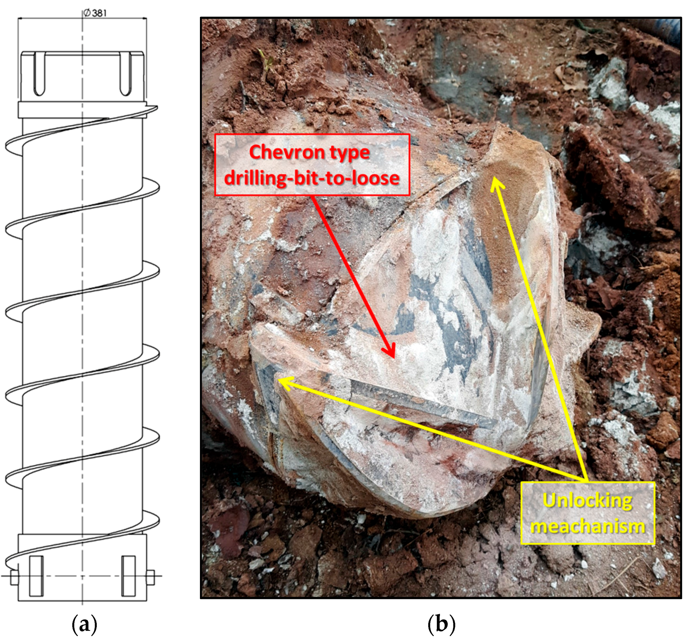
To install the new designed GSHE, the cost-saving standard easy drill technology was modified to the enlarged easy drill technology (EEDT) within this project. The new design consists of 1500-mm long tubes (Figure 2a) with an external diameter of 356 mm. On the outer surface of the tube, a metal spiral with an external diameter of 450 mm has been welded. A drag/chevron-type drill-bit-to-loose has been designed with a low-cost manufacturing approach, and an unlocking system has been designed to unfasten the bit at the end of the drilling (Figure 2b) [6].

2.2. Data Acquisition

The main idea was to identify a European-wide valid data set with the best possible resolution. The data acquisition should provide freely available and digital data with an opportunity for modifications. The working base was selected from several data sources that are on the market with different data quality levels. The first data set was from the European 1G-E project OneGeology-Europe, which created a harmonized data model of geological maps with a scale of 1:1,000,000. The project followed the INSPIRE (INfrastructure for SPatial InfoRmation in Europe) guidelines, but a small amount of countries did not participate [7], which limited the level of accuracy and comprehensiveness. Another potential data set dealing with thermal conductivities of the underground would have been the outcomes of the European ThermoMap project [8]. Within this project, a pan-European outline map providing the very shallow geothermal potential (vSGP) was developed and expressed within ThermoMap-MapViewer [9]. The pedological data set for creating the pan-European outline map was provided by the ESDAC’s (European Soil Data Centre) TXSRFDO (Dominant surface textural class) for STU (soil typological unit) or by national datasets for different test areas on a small-scale level. [10]
The last data sets in the collection were directly from the JRC (Joint Research Centre) of the ESDAC, which is organized under the umbrella of the European Commission. The ESDAC provides several thematic maps for soil-related data that cover Europe almost completely. There is the opportunity to access and download the European Soil Database (ESDB) v2.0 after registration. There are several groups within ESDB, which contain 73 soil-classifying attributes in total. Dominant value maps based on 1 km × 1 km raster data are selectable, as well as additionally corresponding purity and confidence level maps [10,11,12]. The data covers the EU28 states (excluding Iceland and Cyprus) plus Switzerland, Norway, and the Balkans. As shallow geothermal systems could be installed within unconsolidated as well as consolidated material, the attribute group called ‘parent material’ was chosen. This attribute group provided information about the most common material in one spatial location. The attribute PAR-MAT-DOM1 is included in this group, which contains the SGDBE (Soil Geographical Database) codes and values for the “major group code for the dominant parent material of the STU (Soil Typological Units)”. This major group code is called PARMADO1, and it is outlined in Table 1.
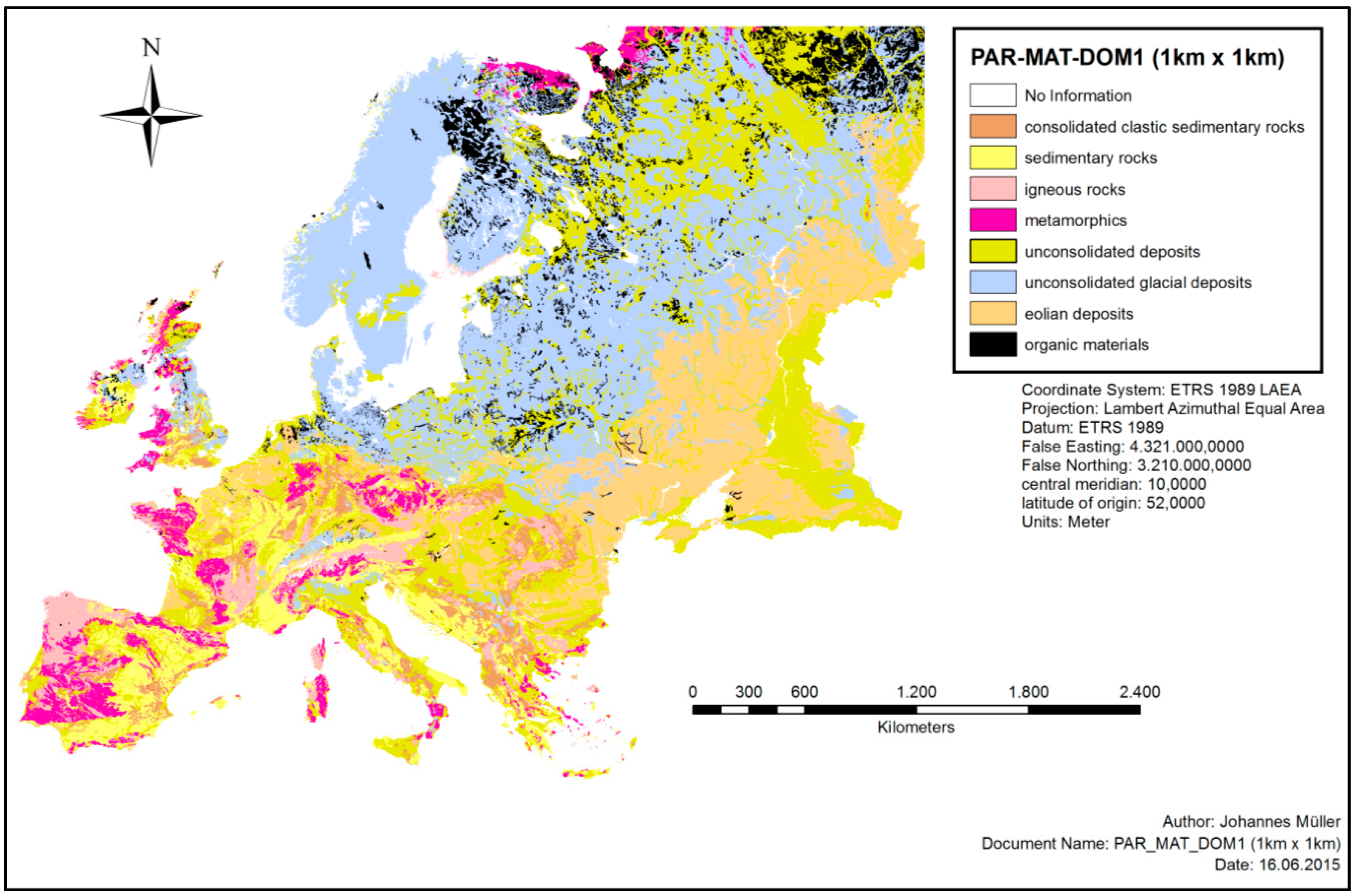
The raster data were downloaded from the ESDB (https://esdac.jrc.ec.europa.eu/content/european-soil-database-v2-raster-library-1kmx1km) to set up a new geodatabase (*.gdb), and to build an ArcGIS project, focusing on geology, drillability, and shallow geothermal systems. Figure 3 shows an already existing working database for further creations of itemized maps covering almost completely the margins of the European Union. Some more peripheral areas, such as Iceland and Cyprus, are not covered within this database.
For the ArcGIS project, there is a single shapefile provided by the ESDAC that contains all 73 soil-classifying attributes with their unique codes and values. The cell size of the grid is maintained constant, with 1 km × 1 km. For the purpose of the Cheap-GSHPs project, only two codes were extracted from the shapefile for further processing: PARMADO and PARMADO1.

2.3. Data Modification

Within a first modification, defined classes were qualified after the level of rock hardness. These descriptions were done in close collaboration with a drilling machine producer and an applied drilling specialist that were participating within the Cheap-GSHPs project. This evaluation is essentially to choose the most practical and economical drilling technique, and to avoid exorbitant costs. In order to unify the major groups of PAR-MAT-DOM1, the sediment classes were structured after their assumed degree of hardness, as shown in Table 2.
Within a certain major group of PAR-MAT-DOM1, the drilling time per meter (using auger, tricone, DTH hammer, etc.) is a function of the level of rock hardness. By applying this classification, predictions are easier to perform when making simplified statements about underground properties. Finally, the end user of the DSS should receive a three-color code that depends on the underground conditions. As a result of this advantage of knowledge, they are able to receive a more detailed offer from a drilling company.
To be more precise, the data set was extended in a second step. The attribute group PAR-MAT-DOM1 was originally built up out of 212 attributes and their corresponding codes from the attribute code PAR-MAT-DOM (Appendix A), the dominant parent material. There, the corresponding PARMADO code consisted of four digits, where the first defined the associated PARMADO1 code. As an example, the transition from PAR-MAT-DOM to PAR-MAT-DOM1 is explained in Table 3.
As the stability, and consequently the drillability, of a borehole depends on the underground’s hardness and grain size, the first approach—to define all unconsolidated materials as slightly consolidated—is not detailed enough to declare drillability classes. In order to provide more exact information, the major groups #5-unconsolidated deposits (alluvium, weathering residuum, and slope deposits), #6-unconsolidated glacial deposits/glacial drift, #7-eolian deposits, and #9-anthropogenic deposits of PAR-MAT-DOM1 were discarded. Furthermore, these attributes were reinterpreted within the PARMADO codes #6000 and #9300 in order to discriminate between codes that contain mostly sandy, clayey, or gravely material. The classification is now focused on the material’s grain size (distribution). Also, additional properties for unconsolidated materials such as water content, bulk density, thermal conductivity, and field capacity could be assigned more specifically to a certain material class.

3. Results

Hardness Map

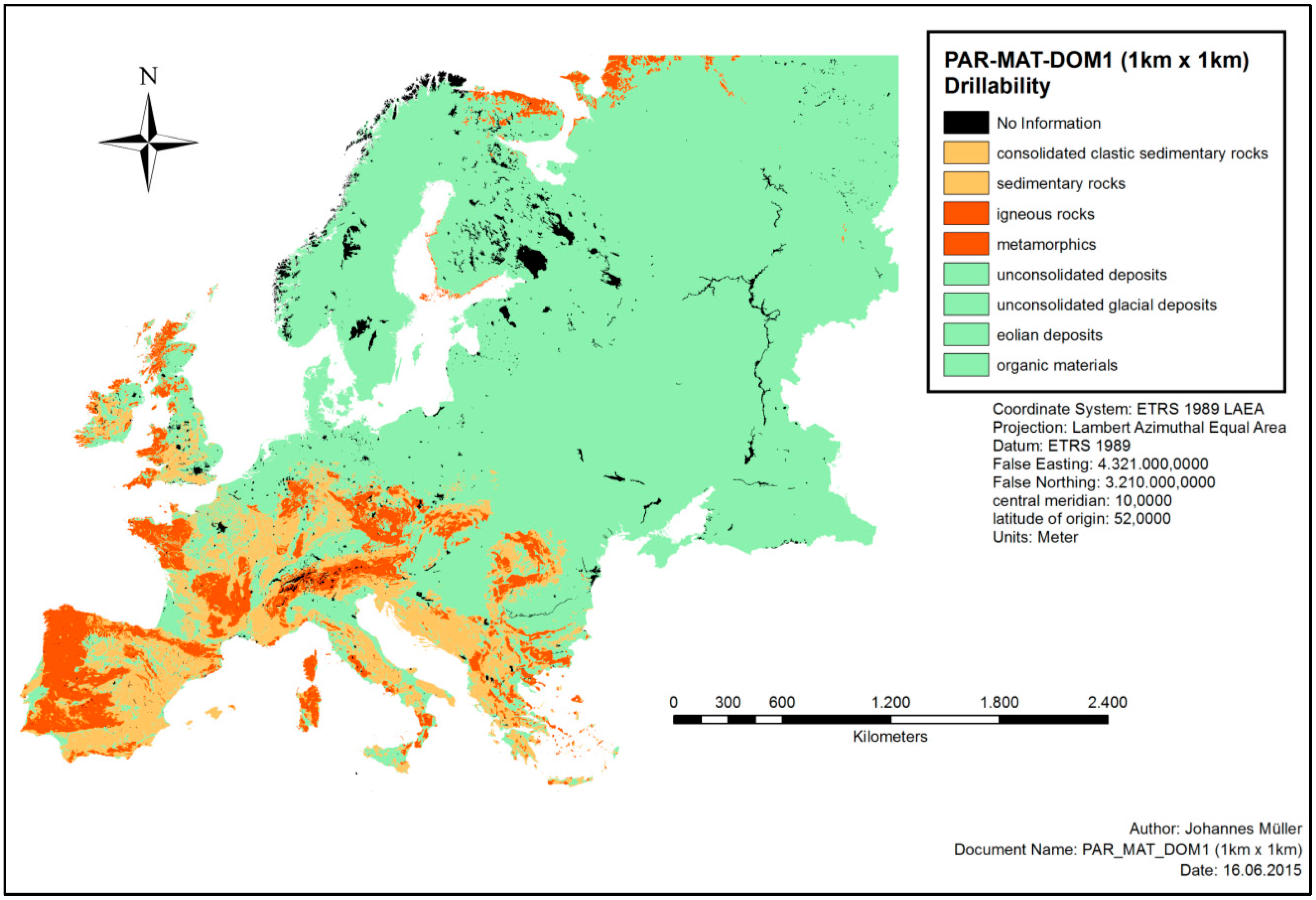
With the focus on the state of hardness, Table 2 was integrated into ArcGIS 10.3 software. The attribute tables of the corresponding shapefile were modified to receive a three-colored map, where red stands for intensively consolidated, orange stands for moderately consolidated and green stands for slightly consolidated lithology conditions. This provides a first hint about the drillability of the material, and which drilling technique will be the most suitable for a given area. A first stage drillability map is displayed in Figure 4.
Within the final map, which was used as a working base for the DSS of the Cheap-GSHPs project, unconsolidated sediments were distinguished between primarily gravely, sandy, or clayey material. The choice of the drilling equipment differs most from the lithology and its geotechnical properties, which are very disparate between the above-mentioned unconsolidated sediments. Further, according to VDI 4640 [13], the thermal conductivity values are different, and this crucially affects the heat extraction. Also, the type of GSHE is specified by the underground’s parameter. For example, areal collector systems are usually not installed in an underground of igneous rock or metamorphic rock. However, probes or heat baskets can be installed through drillings. Therefore, the PAR-MAT-DOM attributes table was re-organized (Table 4) to provide a solution to discriminate these materials from each other, and further predict intending drilling activities at the best possible rate. The result is the attribute group FAU_PAR-MAT-CON, with its codes and values called PARMAFAU.
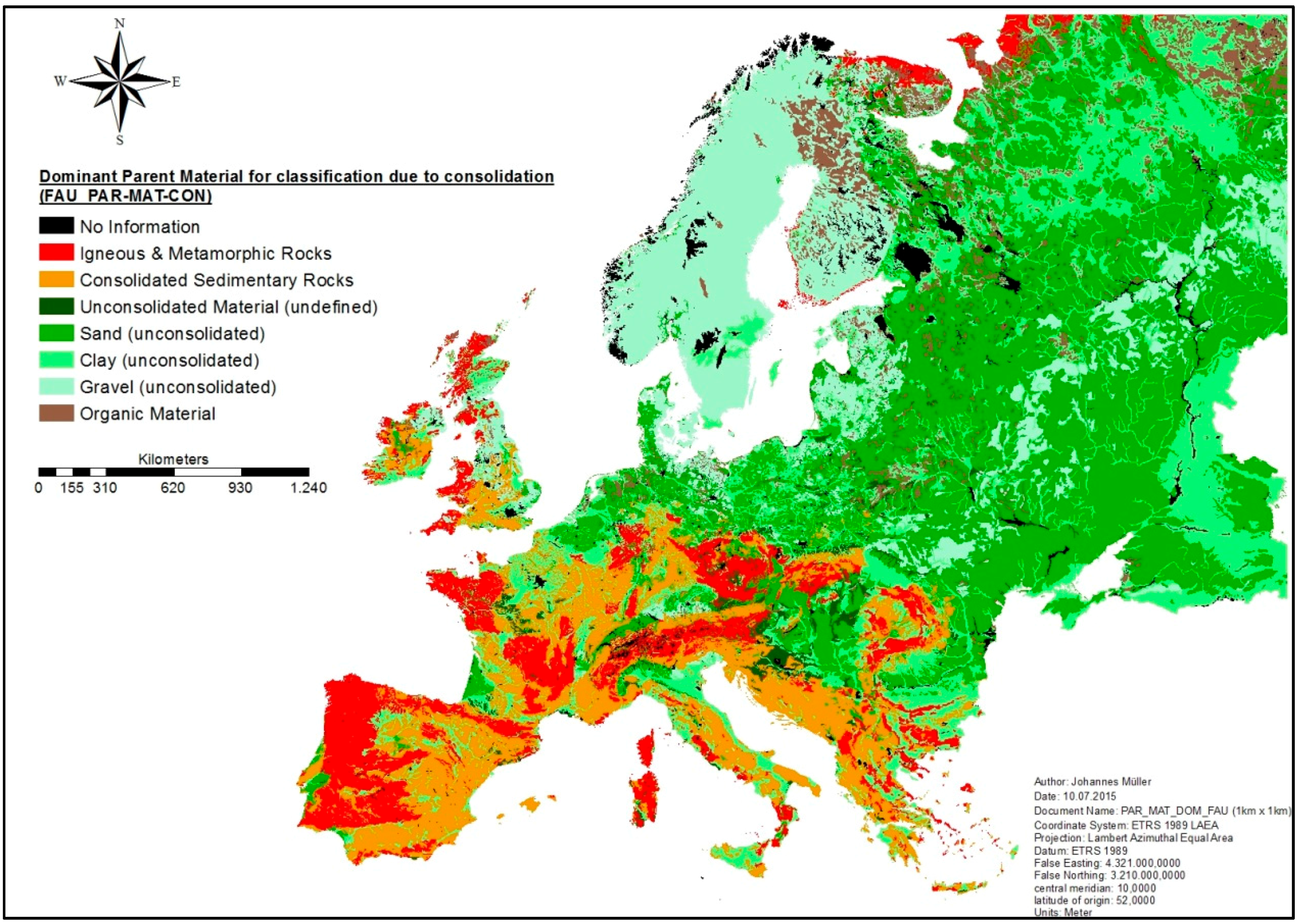
The final attributes group FAU_PAR-MAT-CON contains eight classes: The PARMAFAU value “no information” represents mainly lakes and rivers, metropolises, and peripheral areas such as orogens and fjords. However, undefined anthropogenic material and waste is also added to this attribute. The values “igneous & metamorphic rocks” and “consolidated sedimentary rocks” remain unchanged, and keep their PARMADO codes. “Unconsolidated material (undefined)” represents soft material, and does not differentiate between sand, clay, or gravel as the main component. All of the remaining codes and values of PARMADO were analyzed and redefined according to their grain size and expected occurrence, and were described best with a value of PARMAFAU. Finally the numerous code of PARMAFAU was transferred to the base raster grid with corresponding cell locations, and imported to ArcGIS to generate a new shapefile and produce the final version of the outline map. The final map for the dataset FAU_PAR-MAT-CON is displayed in Figure 5.

4. Discussion

As with every map, Figure 5 has certain limitations in accuracy when making predictions about the lithology in deeper depth regions. In fact, it cannot be ruled out that technical parameter of the lithology might change with the depth. If there are no data from outcrops, the declining accuracy has to be noted. In general, maps try to reflect a three-dimensional system on a two-dimensional image. The map provides only information about the topmost material, and does not provide information about its vertical extent. If lithology changes with depth, the drilling equipment has to be modified, corresponding to a change in hardness. Another parameter that would be very helpful for predicting heat extraction rates and defining drilling requirements is the hydrogeological information. Groundwater presence has a positive effect on the heat extraction rate of many soils and rocks, as thermal conductivity values increase with higher water content [14,15]. Furthermore, drillers and planners have to be aware of the regional groundwater situation, as confined groundwater could lead to problems during the drilling process, which causes high costs for the client or drilling company. On the other side, several technical procedures have to be implemented when drilling in areas with groundwater present. During the approval process for geothermal applications, water protection areas have to be worked out to avoid grounds for rejection, as in many countries, drilling in such areas is forbidden by law. Another important geological aspect that is not covered by the FAU_PAR-MAT-CON data set is the appearance of swellable anhydrite. These sections can lead to extreme costly events of damage (e.g., Staufen im Breisgau, Germany), as anhydrite increases its volume by about 61% if it comes into contact with (ground) water [16]. With this data set, which was generated within the Cheap-GSHPs project, an allocation of thermal conductivities for each FAU_PAR-MAT-CON class could be made according to VDI 4640, part 1, Table 1. However, this is only a rough overview, as the rock-specific thermal conductivity values cover a wide range, and the water saturation also significantly affects the thermal conductivity values.

5. Conclusions

The freely available, INSPIRE conformal, data sets collected by the European Commission via the Joint Research Centre provide a powerful working base for different kind of underground-describing outline maps. The newly created dataset FAU_PAR-MAT-CON provides two major parameters. First, it provides the drillability and hardness of the ground, which are important for defining the major cost factor of the installation of shallow geothermal systems: the drilling costs. Second, in the next step, certain lithologies can be assigned to the literature values of thermal conductivities, which allows a classification in terms of the proposed heat extraction rate. The data sets of the JRC can also be very helpful in other areas of pan-European research as well; they are not only useful for shallow geothermal issues. All of the parameters are needed within the DSS tool of the Cheap-GSHPs project in order to provide the best results for the stakeholders’ planning of a shallow geothermal system. Nevertheless, given that the data and maps described here are presented at a 1 km × 1 km scale, successfully planning and installing GSHE systems will require consultation with experts who are knowledgeable in the underground properties at the site being considered. Our data and maps are intended for use in the first stage in such planning. Notwithstanding the above, this work gives a first idea of what kind of natural circumstances could occur at a certain location, and whether these could cause any difficulties during the drilling process, which could affect the total cost of the installation. Additionally, local regulations and legislations should be considered before the planning phase.

Acknowledgments

This work has received funding from the European Union’s Horizon 2020 research and innovation program under grant agreement No. 657982.

Author Contributions

Matteo Cultrera, Antonio Galgaro and Giorgia Dalla Santa researched into diverse possible data sets, and with Johannes Müller and David Bertermann developed the methodology. Further they created and analysed the results. Constantine Karytsas, Dimitrios Mendrinos, Sebastian Pera, Rodolfo Perego, Nick O’Neill, Riccardo Pasquali, Jacques Vercruysse, Leonardo Rossi and Adriana Bernardi provided technical and theoretical support of data handling. Johannes Müller and David Bertermann wrote the manuscript and all authors reviewed and approved the final version.

Conflicts of Interest

The authors declare no conflict of interest

Appendix A

Table A1. PAR-MAT-DOM: Code for dominant parent material of the STU.
0No information
1000consolidated-clastic-sedimentary rocks
1400facies bound rock
1100psephite or rudite
1410flysch
1110conglomerate
1411sandy flysch
1111pudding stone
1412clayey and silty flysch
1120breccia
1413conglomeratic flysch
1200psammite or arenite
1420molasse
1210sandstone
1211calcareous sandstone
1212ferruginous sandstone
1213clayey sandstone
1214quartzitic sandstone/orthoquartzite
1215micaceous sandstone
1220arkose
1230graywacke
1231feldspathic graywacke
1300pelite, lutite or argilite
1310claystone/mudstone
1311kaolinite
1312bentonite
1320siltstone
2000edimentary rocks (chemically pre-cipitated, evaporated, or organogenic or biogenic in origin)
2100calcareous rocks
2110limestone
2111hard limestone
2112soft limestone
2113marly limestone
2114chalky limestone
2115detrital limestone
2116carbonaceous limestone
2117lacustrine or freshwater limestone
2118travertine/calcareous sinter
2119cavernous limestone
2120dolomite
2121cavernous dolomite
2122calcareous dolomite
2130marlstone
2140marl
2141chalk marl
2142gypsiferous marl
2150chalk
2200evaporites
2210gypsum
2220anhydrite
2230halite
2300siliceous rocks
2310chert, hornstone, flint
2320diatomite/radiolarite
3000igneous rocks
3100acid to intermediate plutonic rocks
3110granite
3120granodiorite
3130diorite
3131quartz diorite
3132gabbro diorite
3140syenite
3200basic plutonic rocks
3210gabbro
3300ultrabasic plutonic rocks
3310peridotite
3320pyroxenite
3400acid to intermediate volcanic rocks
3410rhyolite
3411obsidian
3412quartz porphyrite
3420dacite
3430andesite
3431porphyrite (intermediary)
3440phonolite
3441tephritic phonolite
3450trachyte
3500basic to ultrabasic volcanic rocks
3510basalt
3520diabase
3530pikrite
3600dike rocks
3610aplite
3620pegmatite
3630lamprophyre
3700pyroclastic rocks (tephra)
3710tuff/tuffstone
3711agglomeratic tuff
3712block tuff
3713lapilli tuff
3720tuffite
3721sandy tuffite
3722silty tuffite
3723clayey tuffite
3730volcanic scoria/volcanic breccia
3740volcanic ash
3750ignimbrite
3760pumice
4000metamorphic rocks
4100weakly metamorphic rocks
4110(meta-) shale/argillite
4120slate
4121graphitic slate
4200acid regional metamorphic rocks
4210(meta-) quartzite
4211quartzite schist
4220phyllite
4230micaschist
4240gneiss
4250granulite (sensu stricto)
4260migmatite
4300basic regional metamorphic rocks
4310greenschist
4311prasinite
4312chlorite
4313talc schist
4320amphibolite
4330eclogite
4400ultrabasic regional metamorphic rocks
4410serpentinite
4411greenstone
4500calcareous regional metamorphic rocks
4510marble
4520calcschist, skam
4600rocks formed by contact metamor-phism
4610contact slate
4611nodular slate
4620hornfels
4630calsilicate rocks
4700tectogenetic metamorphism rocks or cataclasmic metamorphism
4710tectonic breccia
4720cataclasite
4730mylonite
5000unconsolidated deposits (alluvium, weathering residuum and slope deposits)
5100marine and estuarine sands
5110pre-quaternary sand
5111tertiary sand
5120quaternary sand
5121holocene coastal sand with shells
5122delta sand
5200marine and estuarine clays and silts
5210pre-quaternary clay and silt
5211tertiary clay
5212tertiary silt
5220quaternary clay and silt
5221holocene clay
5222holocene silt
5300fluvial sands and gravels
5310river terrace sand or gravel
5311river terrace sand
5312river terrace gravel
5320floodplain sand or gravel
5321floodplain sand
5322floodplain gravel
5400fluvial clays, silts and loams
5410river clay and silt
5411terrace clay and silt
5412floodplain clay and silt
5420river loam
5421terrace loam
5430overbank deposit
5431floodplain clay and silt
5432floodplain loam
5500lake deposits
5510lake sand and delta sand
5520lake marl, bog lime
5530lake silt
5600residual and redeposited loams from silicate rocks
5610residual loam
5611stony loam
5612clayey loam
5620redeposited loam
5621running-ground
5700residual and redeposited clays from calcareous rocks
5710residual clay
5711clay with flints
5712ferruginous residual clay
5713calcareous clay
5714non-calcareous clay
5715marly clay
5720redeposited clay
5721stony clay
5800slope deposits
5810slope-wash alluvium
5820colluvial deposit
5830talus scree
5831stratified slope deposits
6000unconsolidated glacial deposits/glacial drift
6100morainic deposits
6110glacial till
6111boulder clay
6120glacial debris
6200glaciofluvial deposits
6210outwash sand, glacial sand
6220outwash gravels glacial gravels
6300glaciolacustrine deposits
6310varves
7000eolian deposits
7100loess
7110loamy loess
7120sandy loess
7200aeolian sands
7210dune sand
7220cover sand
8000organic materials
8100peat (mires)
8110rainwater fed moor peat (raised bog)
8111folic peat
8112fibric peat
8113terric peat
8120groundwater fed bog peat
8200slime and ooze deposits
8210gyttja, sapropel
8300carbonaceaous rocks (caustobiolite)
8310lignite (brown coal)
8320hard coal
8330anthracite
9000anthropogenic deposits
9100redeposited natural materials
9110sand and gravel fill
9120loamy fill
9200dump deposits
9210rubble/rubbish
9220industrial ashes and slag
9230industrial sludge
9240industrial waste
9300anthropogenic organic materials

References

  1. Bertermann, D.; Müller, J. Actual GSHE Installation with Reference Costs and Performances; FAU Erlangen-Nuremberg: Erlangen, Germany, 2015; p. 122. Available online: http://cheap-gshp.eu/wp-content/uploads/2016/07/Cheap-GSHPs_T2.1_FAU_D2.1-vs2.pdf (accessed on 27 November 2017).
  2. Zarrella, A.; Emmi, G.; Graci, S.; De Carli, M.; Cultrera, M.; Dalla Santa, G.; Galgaro, A.; Bertermann, D.; Müller, J.; Pockelé, L.; et al. Thermal Response Testing Results of Different Types of Borehole Heat Exchangers: An Analysis and Comparison of Interpretation Methods. Energies 2017, 10, 801. [Google Scholar] [CrossRef]
  3. Arnold, W. (Ed.) Flachbohrtechnik, 1st ed.; Deutscher Verlag für Grundstoffindustrie: Leipzig, Germany, 1993; pp. 144–162. ISBN 978-3-342-00640-4. [Google Scholar]
  4. State of Michigan. Water Well Drilling Methods. Available online: http://www.michigan.gov/documents/deq/deq-wb-dwehs-gwwfwim-section5_183030_7.pdf (accessed on 27 November 2017).
  5. Buja, H.-O. Handbuch der Baugrunderkennung: Geräte und Verfahren, 1st ed.; Vieweg + Teubner: Wiesbaden, Germany, 2009; pp. 147–153. ISBN 978-3-8348-0544-7. [Google Scholar]
  6. Bernini, M. Design and Costs of GSHEs and Drilling Machines for up to 500 mm; Project Deliverable ‘Cheap-GSHPs’ No. 2.3; HYDRA S.R.L.: Molinella, Italy, 2016; p. 42. Available online: http://cheap-gshp.eu/wp-content/uploads/2017/09/Cheap-GSHP-D2.3.pdf (accessed on 27 November 2017).
  7. OneGeology-Europe. Available online: http://www.eurogeosurveys.org/projects/onegeology-europe/ (accessed on 28 November 2017).
  8. Bertermann, D.; Klug, H.; Morper-Busch, L.; Bialas, C. Modelling vSGPs (very shallow geothermal potentials) in selected CSAs (case study areas). Energy 2014, 71, 226–244. [Google Scholar] [CrossRef]
  9. Bertermann, D.; Klug, H.; Morper-Busch, L. A pan-European planning basis for estimating the very shallow geothermal energy potentials. Renew. Energy 2015, 75, 335–347. [Google Scholar] [CrossRef]
  10. Panagos, P. The European Soil Database. In Proceedings of the Biodiversity Workshop; 2006. Available online: http://eusoils.jrc.ec.europa.eu (accessed on 20 November 2017).
  11. Panagos, P.; Van Liedekerke, M.; Jones, A.; Montanarella, L. European Soil Data Centre: Response to European policy support and public data requirements. Land Use Policy 2012, 29, 329–338. [Google Scholar] [CrossRef]
  12. Van Liedekerke, M.; Jones, A.; Panagos, P. ESDBv2 Raster Library—A Set of Rasters Derived from the European Soil Database Distribution v2. 0; European Commission and the European Soil Bureau Network, CDROM, EUR: Ispra, Italy, 2006. [Google Scholar]
  13. VDI-Gesellschaft Energietechnik (Ed.) 4640 Thermal Use of the Ground. Fundamentals, Approvals, Environmental Aspects, Part 1; Beuth Verlag GmbH: Berlin, Germany, 2000. [Google Scholar]
  14. Robertson, E.C. Thermal Properties of Rocks (No. 88-441). Available online: https://pubs.usgs.gov/of/1988/0441/report.pdf (accessed on 13 November 2017).
  15. Dalla Santa, G.; Peron, F.; Galgaro, A.; Cultrera, M.; Bertermann, D.; Mueller, J.; Bernardi, A. Laboratory Measurements of Gravel Thermal Conductivity: An Update Methodological Approach. Energy Procedia 2017, 125, 671–677. [Google Scholar] [CrossRef]
  16. Sass, I.; Burbaum, U. Damage to the historic town of Staufen (Germany) caused by geothermal drillings through anhydrite-bearing formations. Acta Carsologica 2010, 39. [Google Scholar] [CrossRef]
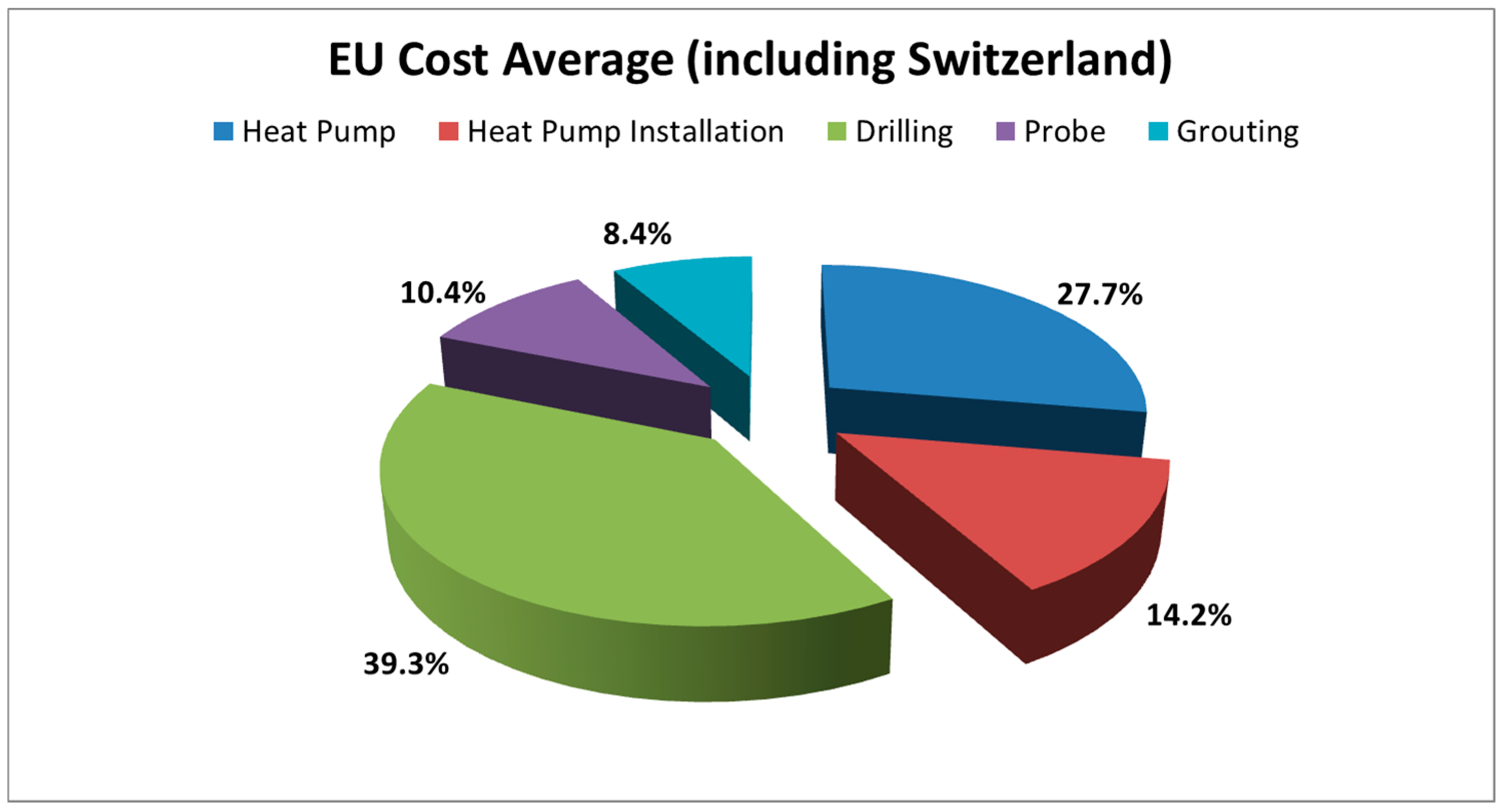
Figure 1. European average costs of a standard geothermal installation outside the house (+in-house located heat pump [1]).
Geosciences 08 00032 g001
Figure 2. Enlarged easy drill technology (EEDT) tools: (a) casing segment with external spiral; (b) drag bit-to-loose for soft, clayey geological conditions.
Geosciences 08 00032 g002
Figure 3. Major groups for dominant, parent material using attributes of PAR-MAT-DOM1, modified after van Liedekerke et al. [12].
Geosciences 08 00032 g003
Figure 4. Drillability map using major groups for dominant parent material and using attributes of PAR-MAT-DOM1 (modified after [10,11,12]). Three classes of hardness: Green = slightly consolidated; orange = moderately consolidated; red = intensively consolidated.
Geosciences 08 00032 g004
Figure 5. Map for the dominant parent material for a classification due to hardness. The map allows assertions about the level of hardness and drillability.
Geosciences 08 00032 g005
Table 1. Soil Geographical Database (SGDBE) values PARMADO1: Major group code for the dominant parent material.
CodeValue
0No information
1Consolidated clastic sedimentary rocks
2Sedimentary rocks (chemically precipitated, evaporated, or organogenic or biogenic in origin)
3Igneous rocks
4Metamorphic rocks
5Unconsolidated deposits (alluvium, weathering residuum, and slope deposits)
6Unconsolidated glacial deposits/glacial drift
7Eolian deposits
8Organic materials
9Anthropogenic deposits
Table 2. Assumed hardness levels of PARMADO1 code.
PARMADO1 CodeValueLevel of Hardness
0No informationNo information
1Consolidated clastic sedimentary rocksModerately consolidated
2Sedimentary rocks (chemically precipitated, evaporated, or organogenic or biogenic in origin)Moderately consolidated
3Igneous rocksIntensively consolidated
4Metamorphic rocksIntensively consolidated
5Unconsolidated deposits (alluvium, weathering residuum and slope deposits)Slightly consolidated
6Unconsolidated glacial deposits/glacial driftSlightly consolidated
7Eolian depositsSlightly consolidated
8Organic materialsSlightly consolidated
9Anthropogenic depositsNo information
Table 3. Relationship between codes of PAR-MAT-DOM and PAR-MAT-DOM1.
Attribute Group
PAR-MAT-DOM
(Group Code for Dominant Parent Material)
Attribute Group
PAR-MAT-DOM1
(Major Group Code for Dominant Parent Material)
Code
PARMADO
Value
PARMADO
Code
PARMADO1
Value
PARMADO1
6000unconsolidated glacial deposits/glacial drift6unconsolidated glacial deposits/glacial drift
6100morainic deposits
6110glacial till
6111boulder clay
6120glacial debris
6200glaciofluvial deposits
6210outwash sand, glacial sand
6220outwash gravels glacial gravels
6300glaciolacustrine deposits
6310varves
Table 4. Relationship between codes of FAU_PAR-MAT-CON and PAR-MAT-DOM.
Attribute Group
FAU_PAR-MAT-CON
Attribute Group
PAR-MAT-DOM
Code
PARMAFAU
Value
PARMAFAU
Code
PARMADO
0No information0 8320 9000 9210 9220 9230 9240 9300
1consolidated
sedimentary rocks
1000 1100 1110 1111 1120 1200 1210 1211 1212 1213 1214 1215 1220 1230 1231 1300 1310 1311 1312 1320 1400 1410 1411 1412 1413, 1420 2100 2110 2111 2112 2113 2114 2115 2116 2117 2118 2119 2120 2121 2122 2130 2140 2141 2142 2150 2200 2210 2220 2230 2300 2310 2320
2igneous & metamorphic
rocks
3000 3100 3100 3120 3130 3131 3132 3140 3200 3210 3300 3310 3320 3400 3410 3411 3412 3420 3430 3431 3440 3441 3450 3500 3510 3520 3530 3600 3610 3620 3630 3700 3710 3711 3712 3713 3720 3721 3722 3723 3730 3740 4000 4100 4110 4120 4121 4200 4210 4211 4220 4230 4240 4250 4260 4300 4310 4311 4312 4313 4320 4330 4400 4410 4411 4500 4510 4520 4600 4610 4611 4620 4630 4700 4710 4720 4730
3sand (unconsolidated)5100 5110 5111 5120 5121 5122 5311 5321 5430 5510 5830 5831 6120 6210 7120 7200 7210 7220
4clay (unconsolidated)5200 5210 5211 5212 5220 5221 5222 5400 5410 5411 5412 5420 5421 5431 5432 5500 5520 5530 5610 5611 5612 5620 5621 5710 5711 5712 5713 5714 5715 5720 5721 5820 6111 6300 6310 7110 9120
5gravel (unconsolidated)5312 5322 5810 6110 6220 9110
6organic material8000 8100 8110 8111 8112 8113 8120 8200 8210 8300 8310 8330
9unconsolidated material (undefined)5000 6000