Assessment of Landslide Pre-Failure Monitoring and Forecasting Using Satellite SAR Interferometry
Abstract
:1. Introduction
2. Materials and Methods
- A database collection composed of 56 past landslides, including pre-failure displacement data inferred from the scientific literature;
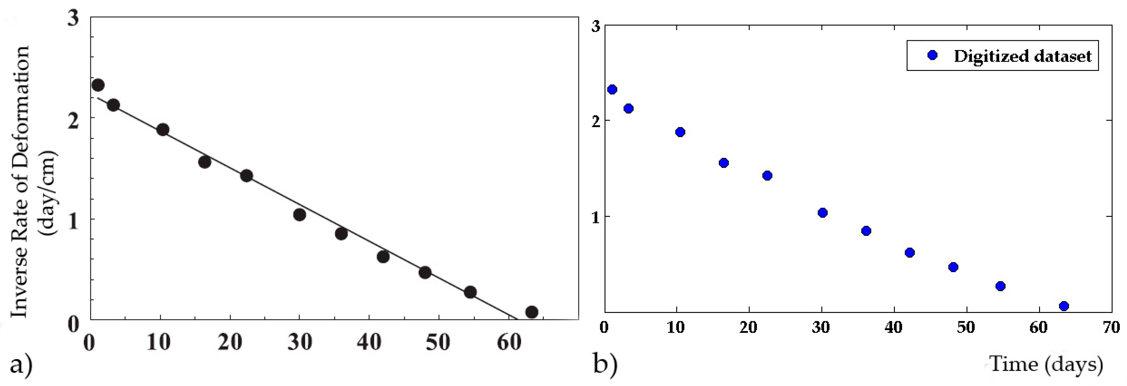
- The digitization of the pre-failure datasets from graphs;
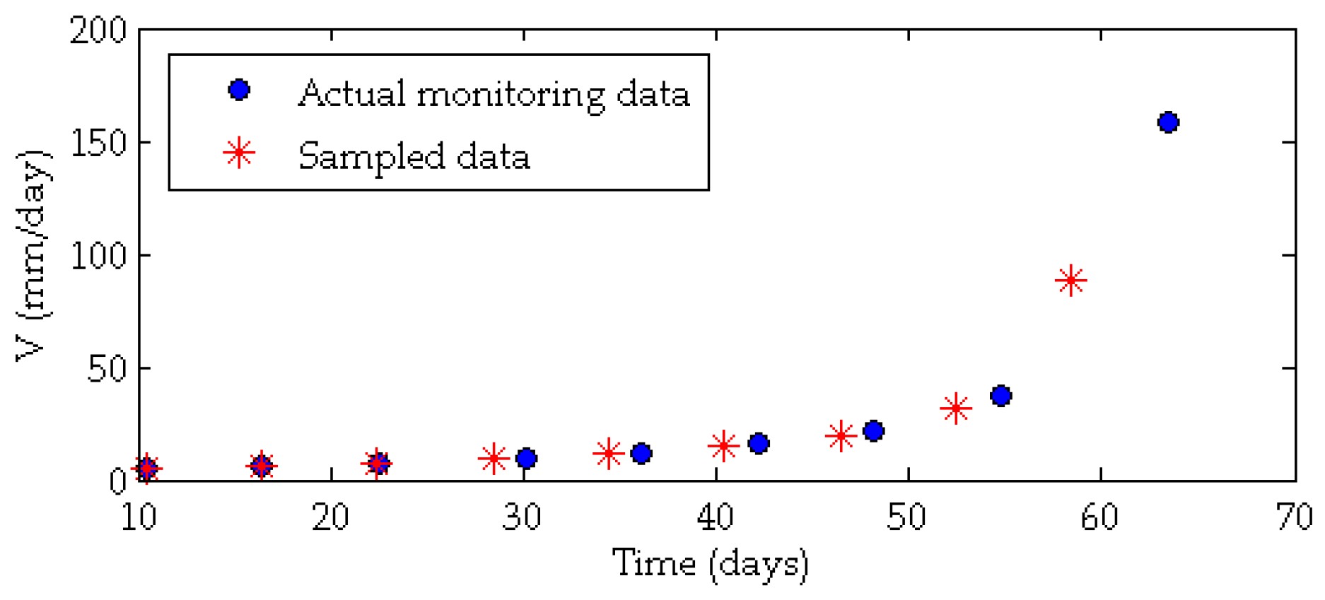
- The sampling of 56 time series of displacements based on different satellites’ revisit time to reproduce the satellite data acquisition;
- Simulation of the phase ambiguity constraint based on the different satellites’ features (wavelength and revisit time);
- The application of four FFMs on three different datasets: (i) digitized datasets, which represent the actual monitoring datasets; (ii) sampled datasets (based on the revisit time constraint); and (iii) simulated datasets (considering the phase ambiguity limit);
- A comparison between the forecast results obtained using actual monitoring data and simulated satellite data.
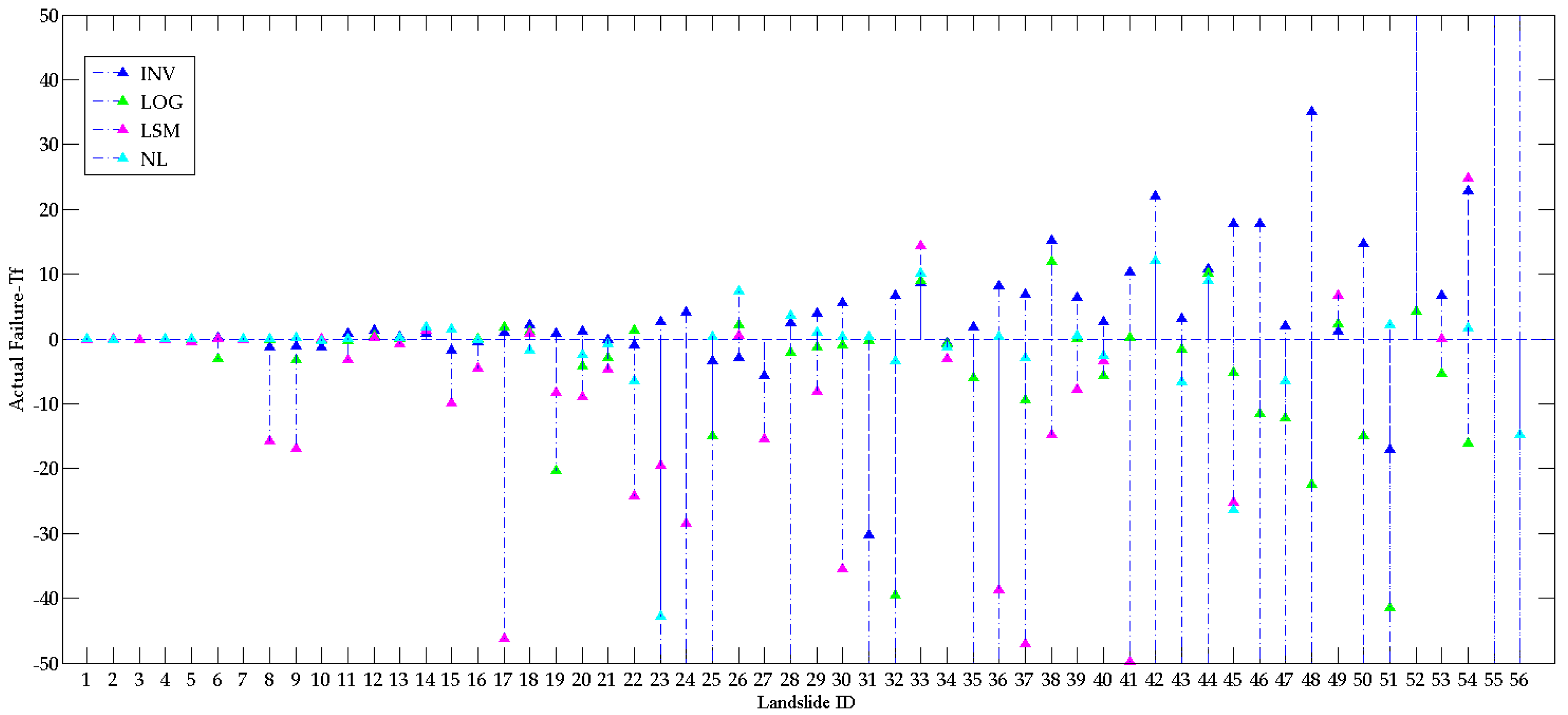
- the actual monitoring data, i.e., the digitized datasets;
- the sampled time series, i.e., the sampled time series based on the satellite’s revisit time;
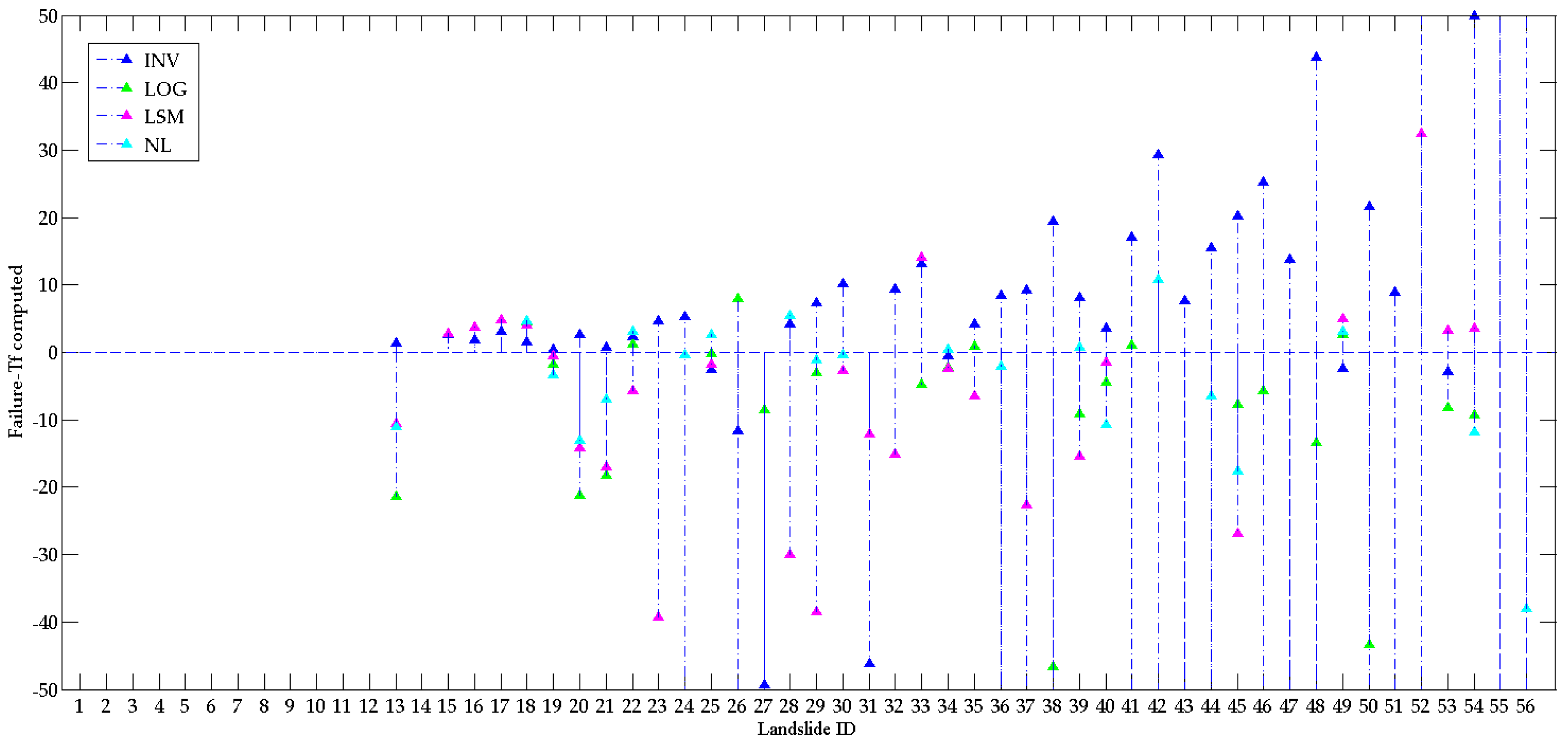
- the simulated time series, which considers the phase ambiguity constraint.
3. Results
3.1. Actual Monitoring Data
3.2. Sampled Datasets
3.3. Simulated Time Series
4. Discussion
5. Conclusions
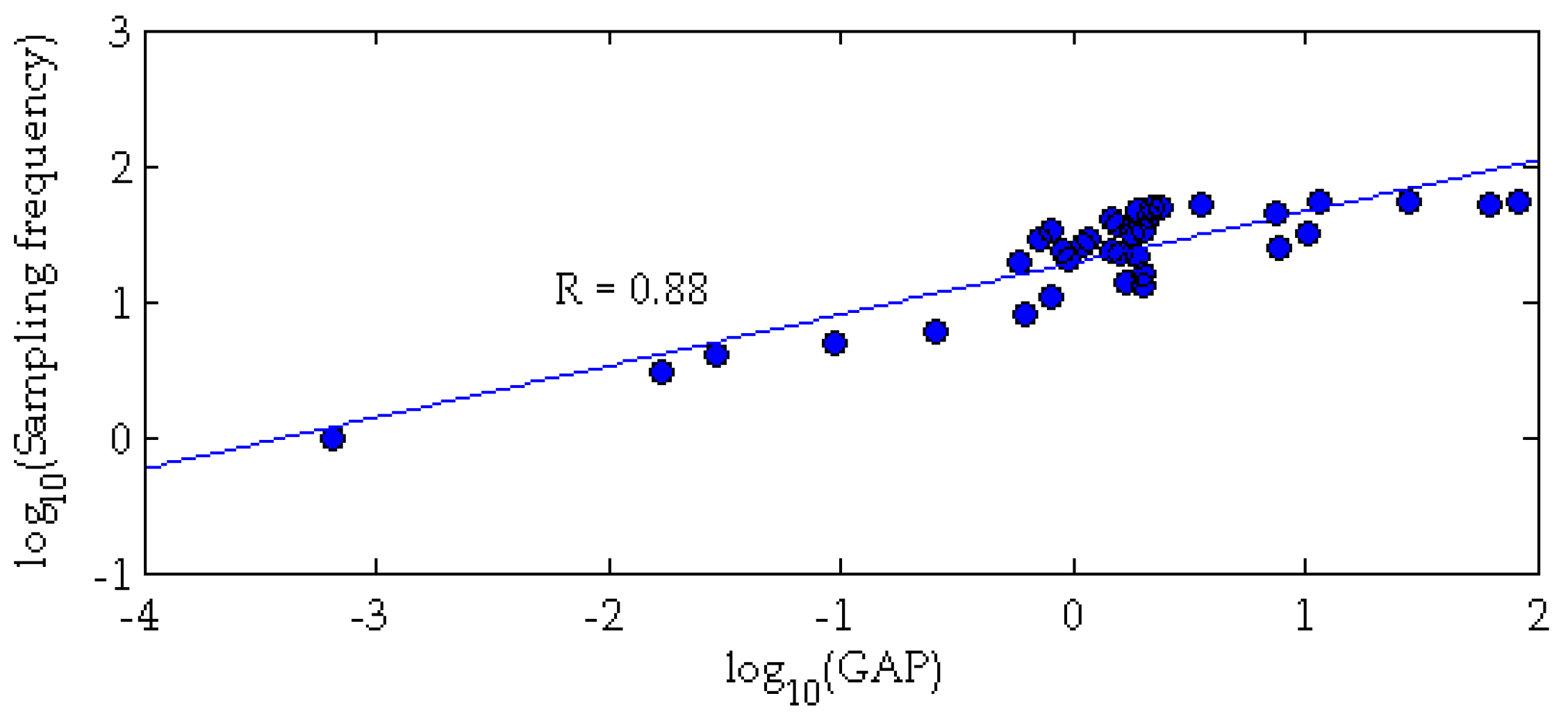
- Monitoring sampling frequency is important for the application of forecasting methods. For some events, an accurate prediction using FFMs on simulated satellite data has been obtained. However, satellite interferometry cannot provide, at present, the sampling frequency required for a reliable FFM for early warning purposes.
- Satellite interferometry has potential for monitoring landslide precursors and for detecting the slopes affected by a change in their deformational behaviour. According to the deformational behaviours of our landslide database, at present, 30% of the events could have been monitored during the acceleration phase with at least three data points, even considering the phase ambiguity constraints. Thus, based on the Sentinel 1A + 1B features, it is possible to monitor 17/56 landslides using satellite SAR interferometry.
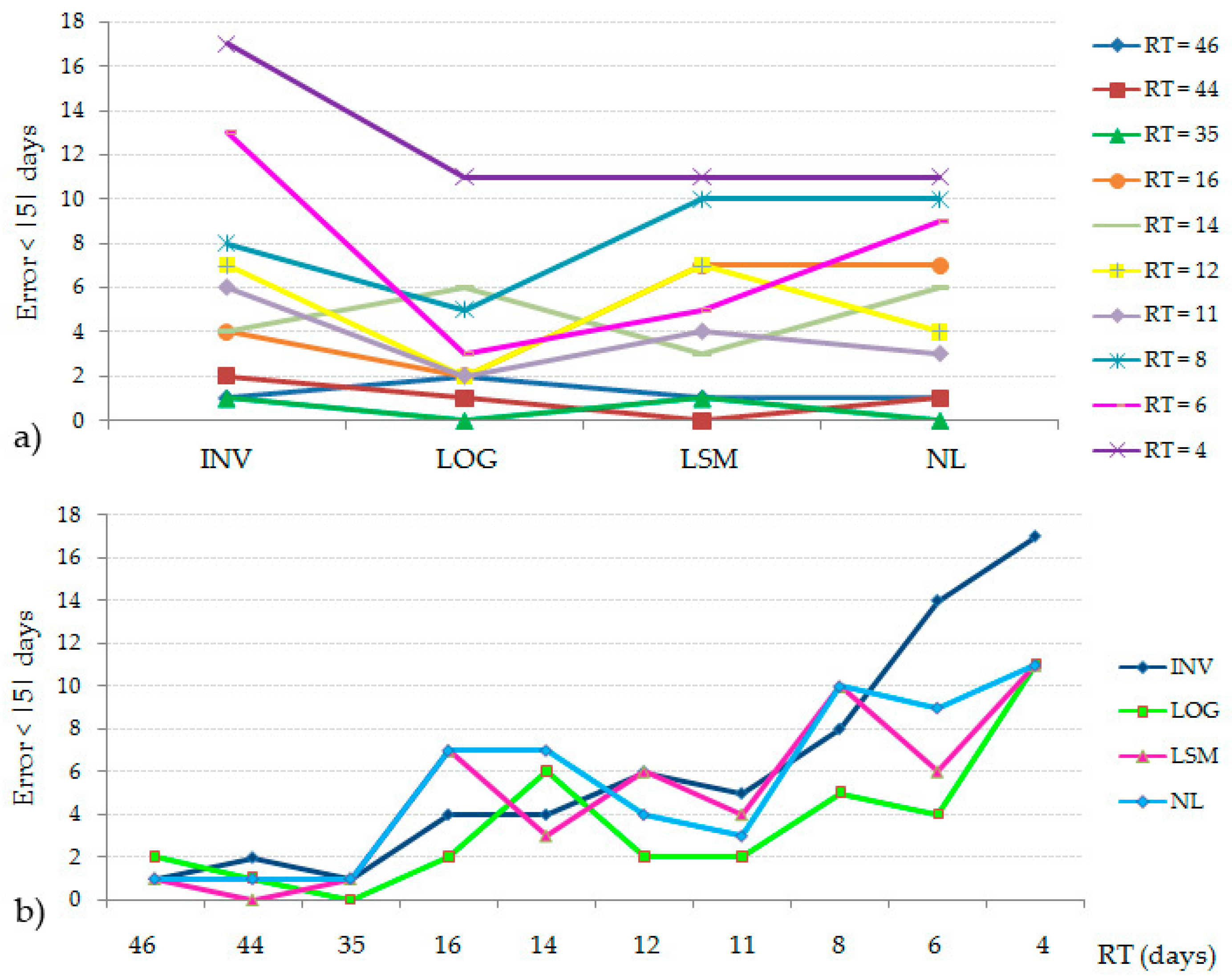
- Considering both the RT and ambiguity phase limits, it would have been possible to forecast a maximum of 4 landslides with an error smaller than 5 days, based on the Sentinel-1 features. This is due to the strong constraints related to the phase ambiguity, which does not allow the monitoring of the high displacement rate occurring during the tertiary creep phase. Notably, it is sometimes possible to monitor consecutive displacements greater than λ/4. If one direction of motion can be assumed (‘upward’ or ‘downward’, as for the majority of landslides), the maximum measurable displacement between a pair of scenarios becomes one-half of the wavelength [28,29]. However, considering λ/2 as the maximum detectable displacement between two consecutive acquisitions, we achieved a similar result: six successful forecasts were obtained based on the Sentinel-1 features.
- If a landslide process is monitored using a suitable technique (high spatial and temporal resolution), forecasting methods can be a powerful tool for risk management and for early-warning systems.
Acknowledgments
Author Contributions
Conflicts of Interest
References
- Heim, A. Bergsturz und Menschenleben; Fretz. & Wasmuth: Zürich, Switzerland, 1932. (In Germany) [Google Scholar]
- Terzaghi, K. Mechanism of landslides. In Application of Geology to Engineering Practice (Berkeley Volume); Geological Society of America: Washington, DC, USA, 1950; pp. 83–123. [Google Scholar]
- Saito, M.; Uezawa, H. Failure of Soil due to Creep. In Proceedings of the 5th International Conference on Soil Mechanics and Foundation Engineering (ICSMFE), Paris, France, 17–22 July 1961; Volume 1, pp. 315–318. [Google Scholar]
- Saito, M. Forecasting the Time of Occurrence of a Slope Failure. In Proceedings of the 6th International Conference on Soil Mechanics and Foundatin Engineering, Montreal, QC, Canada, 8–15 September 1965; pp. 537–541. [Google Scholar]
- Voight, B.; Kennedy, B.A. Slope Failure of 1967–1969, Chuquicamata Mine, Chile. Dev. Geotech. Eng. 1979, 4, 595–632. [Google Scholar]
- Fukuzono, T. A new method for predicting the failure time of a slope. In Proceedings of the 4th International Conference and Field Workshop on Landslides, Tokyo, Japan, 23–31 August 1985; pp. 145–150. [Google Scholar]
- Azimi, C.; Biarez, J.; Desvarreux, P.; Keime, F. Forecasting time of failure for a rockslide in gypsum. In Proceedings of the 5th international symposium on landslides, Lausanne, Switherland, 10–15 July 1988; pp. 531–536. [Google Scholar]
- Voight, B. A relation to describe rate-dependent material failure. Science 1989, 243, 200–203. [Google Scholar] [CrossRef] [PubMed]
- Voight, B. A method for prediction of volcanic eruptions. Nature 1988, 332, 125–130. [Google Scholar] [CrossRef]
- Fukuzono, T. A simple method for predicting the failure time of slope using reciprocal of velocity. Technol. Disaster Prev. Sci. Technol. Agency Jpn. Int. Coop. Agency 1989, 13, 111–128. [Google Scholar]
- Cornelius, R.R.; Voight, B. Graphical and PC-software analysis of volcano eruption precursors according to the materials failure forecast method (FFMS). J. Volcanol. Geotherm. Res. 1995, 64, 295–320. [Google Scholar] [CrossRef]
- Kilburn, C.R.; Petley, D.N. Forecasting giant, catastrophic slope collapse: Lessons from Vajont, Northern Italy. Geomorphology 2003, 54, 21–32. [Google Scholar] [CrossRef]
- Petley, D.N.; Higuchi, T.; Petley, D.J.; Bulmer, M.H.; Carey, J. Development of progressive landslide failure in cohesive materials. Geology 2005, 33, 201–204. [Google Scholar] [CrossRef]
- Petley, D.N.; Petley, D.J.; Allison, R.J. Temporal prediction in landslides. Understanding the Saito effect. In Landslides and Engineered Slopes: From the Past to the Future; Taylor & Francis: Xi’an, China, 2008; pp. 794–800. [Google Scholar]
- Rose, N.D.; Hungr, O. Forecasting potential rock slope failure in open pit mines using the inversevelocity method. Int. J. Rock Mech. Min. Sci. 2007, 44, 308–320. [Google Scholar] [CrossRef]
- Gigli, G.; Fanti, R.; Canuti, P.; Casagli, N. Integration of advanced monitoring and numerical modeling techniques for the complete risk scenario analysis of rockslides: The case of Mt. Beni (Florence, Italy). Eng. Geol. 2011, 120, 48–59. [Google Scholar] [CrossRef]
- Bozzano, F.; Cipriani, I.; Mazzanti, P.; Prestininzi, A. A field experiment for calibrating landslide time-of-failure prediction functions. Int. J. Rock Mech. Min. Sci. 2014, 67, 69–77. [Google Scholar] [CrossRef]
- Mazzanti, P.; Bozzano, F.; Cipriani, I.; Prestininzi, A. New insights into the temporal prediction of landslides by a terrestrial SAR interferometry monitoring case study. Landslides 2015, 12, 55. [Google Scholar] [CrossRef]
- Manconi, A.; Giordan, D. Landslide early warning based on failure forecast models: The example of the Mt. de La Saxe rockslide, northern Italy. Nat. Hazards Earth Syst. Sci. 2015, 15, 1639–1644. [Google Scholar] [CrossRef]
- Sättele, M.; Krautblatter, M.; Bründl, M.; Straub, D. Forecasting rock slope failure: How reliable and effective are warning systems? Landslide 2016, 13, 737. [Google Scholar] [CrossRef]
- Loew, S.; Gschwind, S.; Keller-Signer, A.; Valenti, G. Monitoring and Early Warning of the 2012 Preonzo Catastrophic Rockslope Failure. Landslides 2017, 14, 141. [Google Scholar] [CrossRef]
- Ferretti, A.; Prati, C.; Rocca, F. Nonlinear subsidence rate estimation using permanent scatterers in differential SAR interferometry. IEEE Trans. Geosci. Remote Sens. 2000, 38, 2202–2212. [Google Scholar] [CrossRef]
- Ferretti, A.; Prati, C.; Rocca, F. Permanent scatterers in SAR interferometry. IEEE Trans. Geosc. Remote Sens. 2001, 39, 8–20. [Google Scholar] [CrossRef]
- Berardino, P.; Fornaro, G.; Lanari, R.; Sansosti, E. A new algorithm for surface deformation monitoring based on small baseline differeential SAR interferograms. IEEE Trans. Geosc. Remote Sens. 2002, 40, 2375–2383. [Google Scholar] [CrossRef]
- Perissin, D.; Wang, T. Repeat-Pass SAR Interferometry with Partially Coherent Targets. IEEE Trans. Geosci. Remote Sens. 2012, 50, 271–280. [Google Scholar] [CrossRef]
- Early Warning from Space of Homes on the Slide. Available online: http://www.esa.int/Our_Activities/Observing_the_Earth/Early_warning_from_space_of_homes_on_the_slide (accessed on 9 May 2017).
- Mazzanti, P.; Rocca, A.; Bozzano, F.; Cossu, R.; Floris, M. Landslides Forecasting Analysis by Time Series Displacement Derived from Satellite InSAR Data: Preliminary Results. In Proceedings of the Fringe 2011, Frascati, Italy, 19–23 September 2011. [Google Scholar]
- Ferretti, A.; Prati, C.; Rocca, F.; Nicola, C.; Farina, P.; Young, B. Permanent scatterers technology: A powerful state of the art tool for historic and future monitoring of landslides and other terrain instability phenomena. In International Conference on Landslide Risk Management; Balkema: Vancouver, BC, Canada, 2005. [Google Scholar]
- Crosetto, M.; Monserrat, O.; Iglesias, R.; Crippa, B. Persistent scatterer interferometry: Potential, limits and initial cand X-band comparison. Photogramm. Eng. Remote Sens. 2010, 76, 1061–1069. [Google Scholar] [CrossRef]
- Fukuzono, T. Experimental Study of Slope Failure Caused by Heavy Rainfall. IAHS-AISH Publ. 1987, 165, 133–134. [Google Scholar]
- Moriwaki, H.; Inokuchi, T.; Hattanji, T.; Sassa, K.; Ochiai, H.; Wang, G. Failure processes in a full-scale landslide experiment using a rainfall simulator. Landslides 2012, 1, 277–288. [Google Scholar] [CrossRef]
- Mufundirwa, A.; Fujii, Y.; Kodama, J. A new practical method for prediction of geomechanical failure-time. Int. J. Rock Mech. Min. Sci. 2010, 47, 1079–1090. [Google Scholar] [CrossRef]
- Kayesa, G. Prediction of slope failure at Letlhakane mine with the geomos slope monitoring system. In International Symposium on Stability of Rock Slopes in Open Pit Mining and Civil Engineering; The South African Institute of Mining and Metallurgy: Johannesburg, South Africa, 2006; pp. 606–622. [Google Scholar]
- Saito, M. Forecasting Time of Slope Failure by Tertiary Creep. In Proceedings of the 7th International Conference on Soil Mechanics and Foundation Engineering; Sociedad Mexicana de Mecanica: Mexico City, Mexico, 1969; pp. 677–683. [Google Scholar]
- Manconi, A.; Giordan, D. Landslide failure forecast in near-real-time. Geomat. Nat. Hazard. Risk 2014, 7, 639–648. [Google Scholar] [CrossRef]
- Kent, A. Coal mine waste dumps in British Columbia stability issues and recent developments. Int. Mine Waste Manag. 1992, 10–18. [Google Scholar]
- Iovine, G.; Petrucci, O.; Rizzo, V.; Tansi, C. The march 7th 2005 Cavallerizzo (Cerzeto) Landslide in Calabria—Southern Italy. In Proceedings of the 10th IAEG Congress, Nottingham, UK, 6–10 September 2006; pp. 1–12. [Google Scholar]
- Okamoto, T.; Larsen, J.O.; Matsuura, S.; Asano, S.; Takeuchi, Y.; Grande, L. Displacement properties of landslide masses at the initiation of failure in quick clay deposits and the effects of meteorological and hydrological factors. Eng. Geol. 2004, 72, 233–251. [Google Scholar] [CrossRef]
- Thompson, P.W. Confirmation of a Failure Mechanism Using Open Pit Monitoring Methods. In Proceedings of the Australian Conference on Geotechnical Instrumentation and Monitoring in Open Pit and Underground Mining, Kalgoorlie, Australia, 21–23 June 1993; pp. 483–489. [Google Scholar]
- Glastonbury, B.; Fell, R. Report on the Analysis of the Deformation Behaviour of Excavated Rock Slopes; School of Civil & Environmental Engineering, University of New South Wales: Sydney, Australia, 2002. [Google Scholar]
- GEOPRAEVENT. Available online: www.geopraevent.ch (accessed on10 May 2017).
- Metodi Innovativi per il Controllo e la Gestione dei Fenomeni Franosi. Available online: http://www.eventi.saie.bolognafiere.it/media/saie/presentazioni%20sba/sala%20A/Matteo_Berti.pdf (accessed on 10 May 2017). (In Italian).
- Ulusay, R.; Aksoy, H. Assessment of the failure mechanism of a highwall slope under spoil pile loadings at a coal mine. Eng. Geol. 1994, 38, 117–134. [Google Scholar] [CrossRef]
- Ryan, T.M.; Call, R.D. Applications of Rock Mass Monitoring for Stability Assessment of Pit Slope Failure. In Proceedings of the 33th U.S. Symposium on Rock Mechanics (USRMS), Santa Fe, NM, USA, 3–5 June 1992; Balkema: Rotterdam, The Netherlands, 1992. [Google Scholar]
- Cahill, J.; Lee, M. Ground control at Leinster nickel operations. In International Symposium on Stability of Rock Slopes in Open Pit Mining and Civil. Engineering; The South African Institute of Mining and Metallurgy: Johannesburg, South Africa, 2006; pp. 321–334. [Google Scholar]
- Salt, G. Landslide Mobility and Remedial Measures. In Proceedings of the 5 International Symposium on Landslides, Rotterdam, The Netherlands, 1988; pp. 757–762. [Google Scholar]
- Carey, J.M.; Moore, R.; Petley, D.N.; Siddle, H.J. Pre-failure behaviour of slope materials and their significance in the progressive failure of landslides. In Landslides and Climate Change: Challenges and Solutions; Taylor & Francis Group: London, UK, 2007; pp. 207–215. [Google Scholar]
- Urcioli, G.; Picarelli, L. Interaction between landslides and man-made works. In Landslides and Engineered Slopes; Taylor & Francis Group: London, UK, 2008. [Google Scholar]
- Borsetto, M.; Frassoni, A.; La Barbera, G.; Fanelli, M.; Giuseppetti, G.; Mazzà, G. An application of Voight empirical model for the prediction of soil and rock instabilities. In Proceedings of the 7th International Symposium on Landslides; Bell, D.H., Ed.; Balkema: Rotterdam, The Netherlands; Christchurch, New Zealand, 1991; pp. 335–341. [Google Scholar]
- Petley, D.N. The evolution of slope failures: Mechanisms of rupture propagation. Nat. Hazard. Earth Sys. Sci. 2004, 4, 147–152. [Google Scholar] [CrossRef]
- Bai, J.G.; Lu, S.D.; Han, J.S. Importance of study of creep sliding mechanism to prevention and treatment of reservoir landslide. In Landslides and Engineered Slopes: From the Past to the Future; Taylor & Francis Group: Xi’an, China, 2008; pp. 1071–1076. [Google Scholar]
- Bhandari, R.K. Special lecture—Some practical lessons in the investigation and field monitoring of landslides. Landslides 1988, 1–3, 1435–1457. [Google Scholar]
- Zavodni, Z.M.; Broadbent, C.D. Slope failure kinematics. CIM Bull. 1980, 69–74. [Google Scholar]
- Brawner, C.O.; Stacey, P.F. Hogarth pit slope failure, Ontario, Canada. In Rockslides and Avalanches, B; Elsevier: Amsterdam, The Netherlands, 1979; pp. 691–707. [Google Scholar]
- Glastonbury, B.; Fell, R. Report On the Analysis of Rapid Natural Rock Slope. R-390; School of Civil & Environmental, University of New South Wales (UNSW): Sydney, Australia, 2001. [Google Scholar]
- Brown, I.; Hittinger, M.; Goodman, R. Finite element study of the Nevis Bluff (New Zealand) rock slope failure. Rock Mech. 1980, 12, 231–245. [Google Scholar] [CrossRef]
- Keqiang, H.; Sijing, W. Double-parameter threshold and its formation mechanism of the colluvial landslide: Xintan landslide, China. Environ. Geol. 2006, 49, 696–707. [Google Scholar] [CrossRef]
- Schumm, S.A.; Chorley, R.J. The fall of Threatening Rock. Am. J. Sci. 1964, 262, 1041–1054. [Google Scholar] [CrossRef]
- D’Elia, B.; Picarelli, L.; Leroueil, S.; Vaunat, J. Geotechnical characterisation of slope movements in structurally complex clay soils and stiff jointed clays. Riv. Ital. Geotec. 1998, 3, 5–47. [Google Scholar]
- Zabusky, L.; Swidzinski, W.; Kulczykowski, M.; Mrozek, T.; Laskowicz, I. Monitoring of landslides in the Brada river valley in Koronowo (Polish Lowlands). Environ. Earth Sci. 2015, 73, 8609–8619. [Google Scholar] [CrossRef]
- Boyd, J.M.; Hinds, D.V.; Moy, D.; Rogers, C. Two simple devices for monitoring movements in rock slopes. Quart. J. Eng. Geol. Hydrogeol. 1973, 6, 295–302. [Google Scholar] [CrossRef]
- Siqing, Q.; Sijing, W. A homomorphic model for identifying abrupt abnormalities of landslide forerunners. Eng. Geol. 2000, 57, 163–168. [Google Scholar] [CrossRef]
- Royán, M.J.; Abellán, A.; Vilaplana, J.M. Progressive failure leading to the 3 December 2013 rockfall at Puigcercós scarp (Catalonia, Spain). Landslides 2015, 12, 585–595. [Google Scholar] [CrossRef]
- Muller, L. The rock slide in the Vaiont valley. Felsmech. Ing. 1964, 42, 148–212. [Google Scholar]
- Bozzano, F.; Mazzanti, P.; Esposito, C.; Moretto, S.; Rocca, A. Potential of satellite InSAR monitoring for landslide Failure Forecasting. In Landslides and Engineered Slopes. Experience, Theory and Practice; CRC Press: Boca Raton, FL, USA, 2016; Volume 2, pp. 523–530. [Google Scholar]
- Moretto, S.; Bozzano, F.; Esposito, C.; Mazzanti, P. Lesson learned from the pre-collapse time series of displacement of the Preonzo landslide (Switzerland). Rend. Online Soc. Geol. Ital. 2016, 41, 247–250. [Google Scholar] [CrossRef]


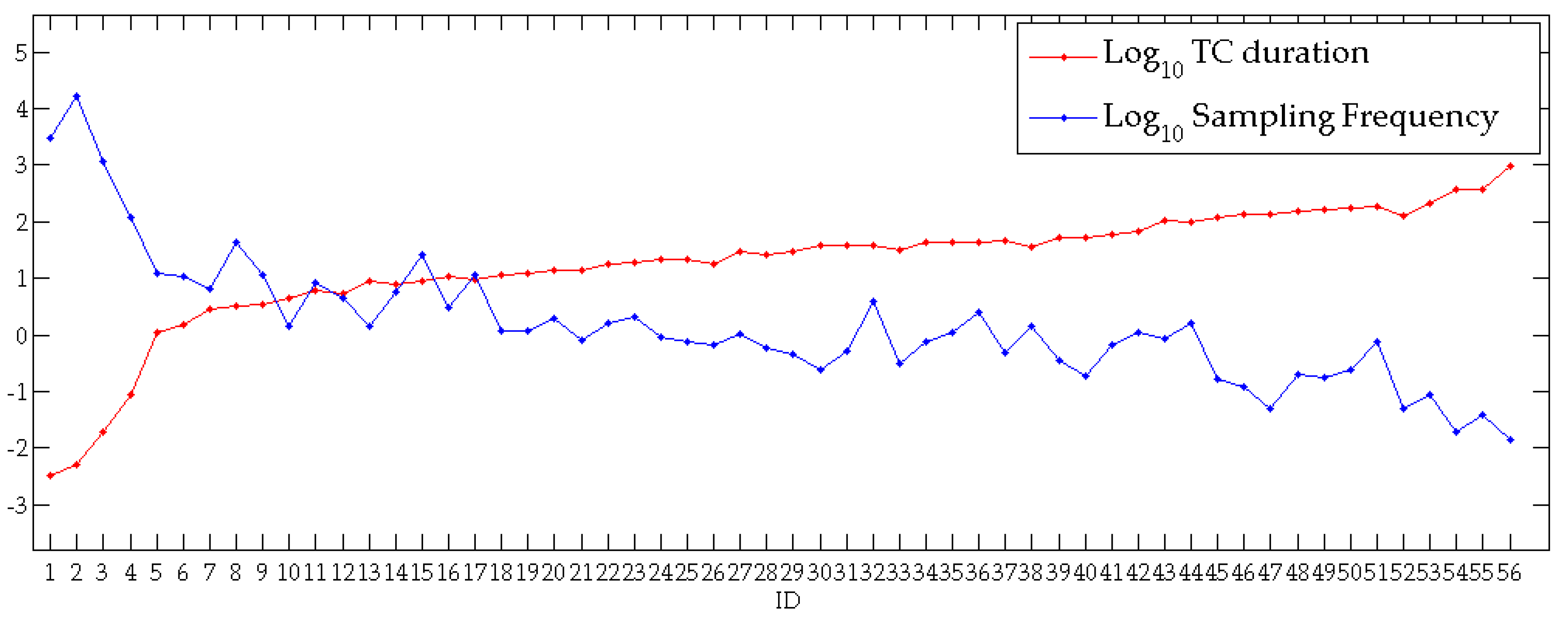
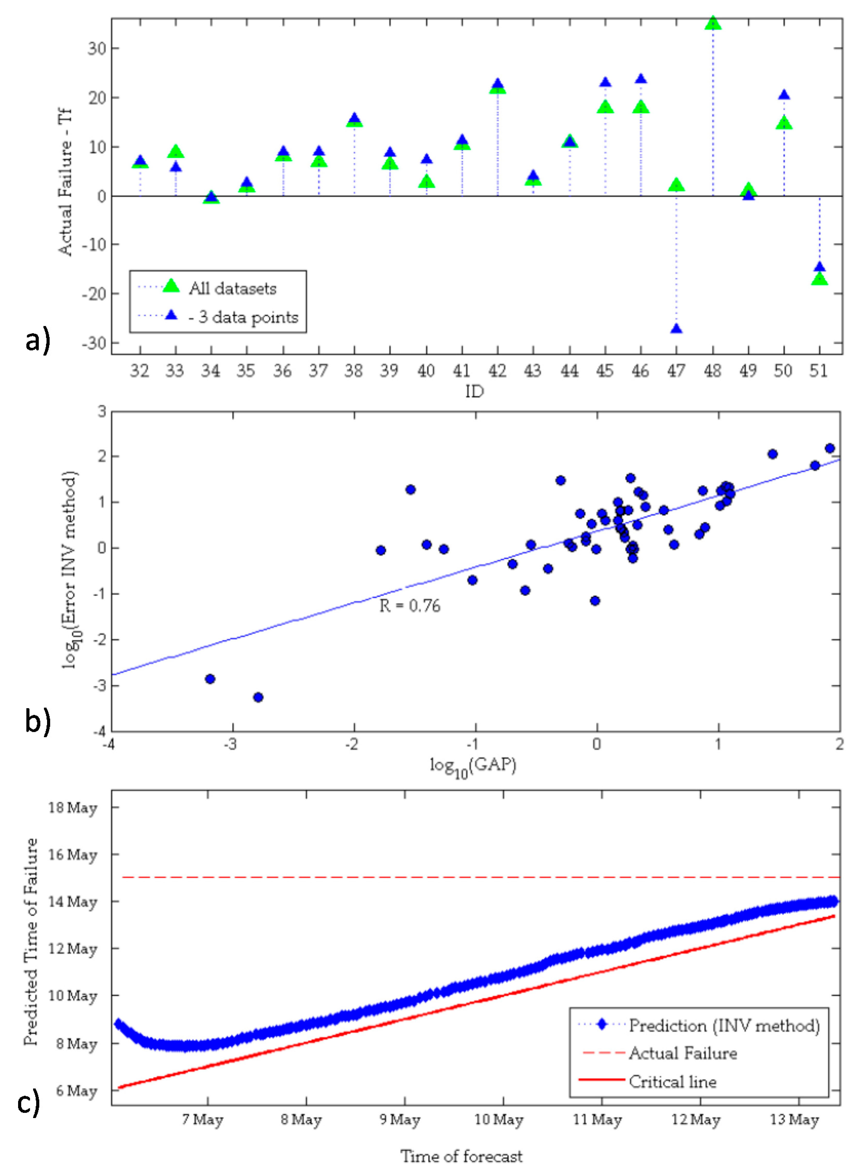
| Landslide | Reference | ID | Tertiary Creep (TC) Length (days) | Average Velocity (mm/day) |
|---|---|---|---|---|
| Jitsukiyama | [30] | 1 | 0.01 | 0.04 (mm/s) |
| Moriwaki Experiment | [31] | 2 | 0.02 | 0.04 (mm/min) |
| Unnamed Mufundirawa | [32] | 3 | 0.1 | 0.87 (mm/s) |
| Letlhakane Mine | [33] | 4 | 0.2 | 68.60 (mm/h) |
| Dosan Line | [34] | 5 | 1.2 | 664.79 |
| La Saxe | [35] | 6 | 1.6 | 4541.68 |
| Betz Post 2 mc | [15] | 7 | 3.2 | 63.42 |
| Asamushi | [34] | 8 | 3.4 | 163.76 |
| Rock Dump | [36] | 9 | 4.1 | 1011.21 |
| Cavallerizzo | [37] | 10 | 4.3 | 26.32 |
| Roesgrenda B | [38] | 11 | 6 | 171.93 |
| Tuckabianna West | [39] | 12 | 6.1 | 39.55 |
| Afton | [40] | 13 | 9.4 | 591.07 |
| Excavation A | [40] | 14 | 9.7 | 14.22 |
| Preonzo | [41] | 15 | 10.6 | 91.30 |
| Silla Montecchi | [42] | 16 | 10.8 | 80.31 |
| Eskihisar Coal Mine | [43] | 17 | 11.5 | 6.72 |
| Ryan Call Slide1 | [44] | 18 | 12.8 | 1564.10 |
| Crack Gauge | [45] | 19 | 13 | 11.98 |
| Ruahihi | [46] | 20 | 14.1 | 54.58 |
| Es.2 Rose & Hungr2007 | [15] | 21 | 15 | 52.16 |
| Roesgrenda A | [38] | 22 | 20.1 | 2.00 |
| Abbotsford | [46] | 23 | 20.4 | 106.26 |
| New Tredegar | [47] | 24 | 22.5 | 36.22 |
| Victorious East Pit | [40] | 25 | 22.7 | 4.56 |
| Haveluck | [40] | 26 | 25.8 | 1.94 |
| Bohemia | [48] | 27 | 30.3 | 0.51 |
| Val Pola | [49] | 28 | 30.5 | 51.33 |
| Luscar_51B2 | [40] | 29 | 31.6 | 76.73 |
| Ooigawa Railroad | [34] | 30 | 38.9 | 12.76 |
| Telfer | [40] | 31 | 39.4 | 2.73 |
| Liberty Pit Mine | [15] | 32 | 40.2 | 4.73 |
| Selbourn | [50] | 33 | 41.5 | 100.54 |
| Betz Post 18mc | [15] | 34 | 44 | 6.58 |
| Lijiaxia | [51] | 35 | 44.7 | 4.47 |
| Takabayama | [52] | 36 | 44.9 | 145.78 |
| Kennekott#1 | [53] | 37 | 46.9 | 57.19 |
| Chuquicamata Mine2 | [52] | 38 | 47.6 | 224.24 |
| Ryan Call Slide2 | [44] | 39 | 53.7 | 21.35 |
| Vajont | [13] | 40 | 54.6 | 30.41 |
| Luscar 50A2 | [40] | 41 | 60.9 | 1272.11 |
| Hogart | [54] | 42 | 77.8 | 63.85 |
| Roberts | [55] | 43 | 105 | 57.46 |
| Nevis Bluff | [56] | 44 | 110.4 | 2.98 |
| Monte Beni | [16] | 45 | 132.2 | 19.67 |
| Xintan | [57] | 46 | 138.9 | 459.60 |
| Azimi 1988 | [7] | 47 | 143.8 | 3.39 |
| Threatening Rock | [58] | 48 | 153.8 | 2.49 |
| Bomba | [59] | 49 | 167.9 | 10.86 |
| Smoky River | [40] | 50 | 174.2 | 1.59 |
| Scalate | [55] | 51 | 183.7 | 0.76 |
| Brada River | [60] | 52 | 187.8 | 0.10 |
| Excavation C | [40] | 53 | 211.3 | 1.22 |
| Delabole Quarry | [61] | 54 | 380.7 | 2.89 |
| Saleshan | [62] | 55 | 631.3 | 1.88 |
| Puigcercos Scarp | [63] | 56 | 1013 | 0.39 |
| Period | Satellite | Revisit Time (days) | Band | λ (mm) |
|---|---|---|---|---|
| Past | ALOS PALSAR 1 | 46 | L | 236 |
| J-ERS | 44 | L | 235 | |
| ERS 1/2-Envisat | 35 | C | 56 | |
| Present | COSMO-SkyMed | 4 | X | 31 |
| 8 | X | 31 | ||
| 16 | X | 31 | ||
| Sentinel-1A | 12 | C | 56 | |
| Sentinel 1A + 1B | 6 | C | 56 | |
| ALOS PALSAR 2 | 14 | L | 236 | |
| TerraSAR-X | 11 | X | 31 | |
| Future | Radarsat Constellation | 4 | C | 56 |
| Period | Satellite | RT (Days) | Band | λ (mm) | Compatible Landslides (Revisit Time) | E < |5| Days INV | E < |5| Days LOG | E < |5| Days LSM | E < |5| Days NL |
|---|---|---|---|---|---|---|---|---|---|
| Number of Landslides | |||||||||
| Past | ALOS PALSAR 1 | 46 | L | 236 | 14 | 1 | 2 | 1 | 1 |
| J-ERS | 44 | L | 235 | 14 | 2 | 1 | 0 | 1 | |
| ERS 1/2-Envisat | 35 | C | 56 | 14 | 1 | 0 | 1 | 0 | |
| Present | COSMO-SkyMed | 4 | X | 31 | 43 | 17 | 11 | 11 | 11 |
| 8 | X | 31 | 35 | 8 | 5 | 10 | 10 | ||
| 16 | X | 31 | 26 | 4 | 2 | 7 | 7 | ||
| Sentinel-1A | 12 | C | 56 | 30 | 7 | 2 | 7 | 4 | |
| Sentinel 1A + 1B | 6 | C | 56 | 38 | 13 | 3 | 5 | 9 | |
| ALOS PALSAR 2 | 14 | L | 236 | 29 | 4 | 6 | 3 | 6 | |
| TerraSAR-X | 11 | X | 31 | 30 | 6 | 2 | 4 | 3 | |
| Future | Radarsat Constellation | 4 | C | 56 | 43 | 17 | 11 | 11 | 11 |
| Period | Satellite | RT (days) | Band | λ (mm) | Compatible Landslides (RT) | Compatible Landslides (Phase Ambiguity) | E < |5| days INV | E < |5| days LOG | E < |5| days LSM | E < |5| days NL |
|---|---|---|---|---|---|---|---|---|---|---|
| Number of Landslides | ||||||||||
| Past | ALOS PALSAR 1 | 46 | L | 236 | 14 | 7 | 0 | 1 | 0 | 0 |
| J-ERS | 44 | L | 235 | 14 | 8 | 0 | 0 | 0 | 0 | |
| ERS ½-Envisat | 35 | C | 56 | 14 | 4 | 1 | 0 | 1 | 0 | |
| Present | COSMO-SkyMed | 4 | X | 31 | 43 | 19 | 3 | 0 | 3 | 1 |
| 8 | X | 31 | 35 | 11 | 0 | 0 | 2 | 0 | ||
| 16 | X | 31 | 26 | 9 | 0 | 0 | 0 | 0 | ||
| Sentinel-1A | 12 | C | 56 | 30 | 11 | 1 | 0 | 0 | 0 | |
| Sentinel 1A + 1B | 6 | C | 56 | 38 | 17 | 4 | 3 | 2 | 1 | |
| ALOS PALSAR 2 | 14 | L | 236 | 29 | 14 | 1 | 2 | 1 | 1 | |
| TerraSAR-X | 11 | X | 31 | 30 | 9 | 0 | 0 | 0 | 0 | |
| Future | Radarsat Constellation | 4 | C | 56 | 43 | 24 | 4 | 1 | 4 | 2 |
© 2017 by the authors. Licensee MDPI, Basel, Switzerland. This article is an open access article distributed under the terms and conditions of the Creative Commons Attribution (CC BY) license (http://creativecommons.org/licenses/by/4.0/).
Share and Cite
Moretto, S.; Bozzano, F.; Esposito, C.; Mazzanti, P.; Rocca, A. Assessment of Landslide Pre-Failure Monitoring and Forecasting Using Satellite SAR Interferometry. Geosciences 2017, 7, 36. https://doi.org/10.3390/geosciences7020036
Moretto S, Bozzano F, Esposito C, Mazzanti P, Rocca A. Assessment of Landslide Pre-Failure Monitoring and Forecasting Using Satellite SAR Interferometry. Geosciences. 2017; 7(2):36. https://doi.org/10.3390/geosciences7020036
Chicago/Turabian StyleMoretto, Serena, Francesca Bozzano, Carlo Esposito, Paolo Mazzanti, and Alfredo Rocca. 2017. "Assessment of Landslide Pre-Failure Monitoring and Forecasting Using Satellite SAR Interferometry" Geosciences 7, no. 2: 36. https://doi.org/10.3390/geosciences7020036
APA StyleMoretto, S., Bozzano, F., Esposito, C., Mazzanti, P., & Rocca, A. (2017). Assessment of Landslide Pre-Failure Monitoring and Forecasting Using Satellite SAR Interferometry. Geosciences, 7(2), 36. https://doi.org/10.3390/geosciences7020036


