Abstract
The Upper Pennsylvanian Casselman Formation of southeastern Ohio contains four distinct paleosol types that formed in alluvial systems within the distal Appalachian foreland basin. The properties of these paleosols as well as their small-scale lateral and vertical variations were studied to interpret the paleoenvironmental and paleoecological conditions within the alluvial settings in which they formed. The ichnofossils and pedogenic features preserved within the paleosols of the Casselman Formation record the local climactic, hydrologic, biotic, and topographic changes that occurred in the region during the Late Pennsylvanian. The four paleosols types of the Casselman Formation are interpreted as Alfisols (Type A, Type D), Vertisols (Type B), and Inceptisols (Type D). The four paleosol types indicate different degrees of changes in local moisture regimes including water table fluctuations due to seasonal precipitation and flooding events. The assemblages of ichnofossils within the paleosol types were produced by both soil arthropods and a diverse array of plants that formed part of the different soil ecosystems present within the alluvial environment. Although regional-scale studies are important for understanding the Late Pennsylvanian world, small-scale studies are also necessary to fully understand the local pedogenic, paleoenvironmental, and paleoecologic consequences of global scale changes in paleoclimate and paleogeography.
1. Introduction
Marine sedimentology and ichnology have long been used to deduce the variability in paleoenvironmental and paleoecological conditions such as turbidity, salinity, nutrient input, and biomass across heterogeneous environments [1,2,3,4,5,6]. Although terrestrial landscape surfaces are known to be diverse and, like their marine counterparts, vary in response to minor differences in external conditions such as topographic position, sedimentation, and energy inputs, few have studied the lateral variability of ancient terrestrial soil systems [7,8,9,10,11,12,13]. The purpose of this paper is to use the paleopedology and ichnology of continental strata within the Late Pennsylvanian Casselman Formation to document the small-scale (1–200 m) lateral and vertical variability present in some terrestrial landscapes.
Paleosols are useful for solving diverse geological problems. In the past two decades paleosols have been used to aid in stratigraphic studies, sequence stratigraphy, and continental ichnology [7,8,9,10,14,15,16,17,18,19]. The influence of environmental factors such as parent material, climate, organisms, topography, and time on soil formation is well documented in the modern and can be applied to paleosols [19,20,21,22,23]. For example, the depth of calcic or gypsic horizons as well as the clay mineralogy within paleosols has been used to estimate mean annual temperature and mean annual precipitation [24,25]. Studies involving preserved soil catenas have been used to deduce the paleotopographic positions of paleosols [26]. Specific depositional settings and associated rates of sedimentation, erosion, and pedogenesis are estimated by examining the soil profile types, stacking patterns, and variations in the thicknesses of soil horizons [8,14,19]. Continental ichnology has been used to determine the soil ecology and biomass of paleosols [12,13,23,27,28]. The volume of sedimentological, stratigraphic, geochemical, and biological data that can be gained from paleosols, therefore, makes them excellent indicators of paleoenvironmental, paleoclimatic, and paleoecological conditions [8,9,10,12,16,29,30].
Ichnofossils are biologically produced structures that result from the movement of an organism through or on a medium [4]. They are the products of the life activities of organisms, which include the search for concealment, food, shelter, and escape from adverse conditions [4]. Unlike body fossils, which are often altered and transported beyond the normal habitat of the organism, ichnofossils are preserved in situ, and therefore represent the behaviors and activities of an organism in direct response to the environment in which they were preserved [4]. Changes in diversity and abundance of ichnofossils within ichnocoenoses (faunal communities) have been used to indicate shifts in terrestrial ecosystems related to changes in soil moisture regimes, nutrient content and soil bulk density [12,13,16,23,29]. Along with paleosols, continental ichnofossils have proven to be invaluable to the reconstruction of terrestrial paleoenvironmental, paleoecological, and paleoclimatic conditions [2,9,12,16,22,23,27,31,32,33].
2. Geologic Setting
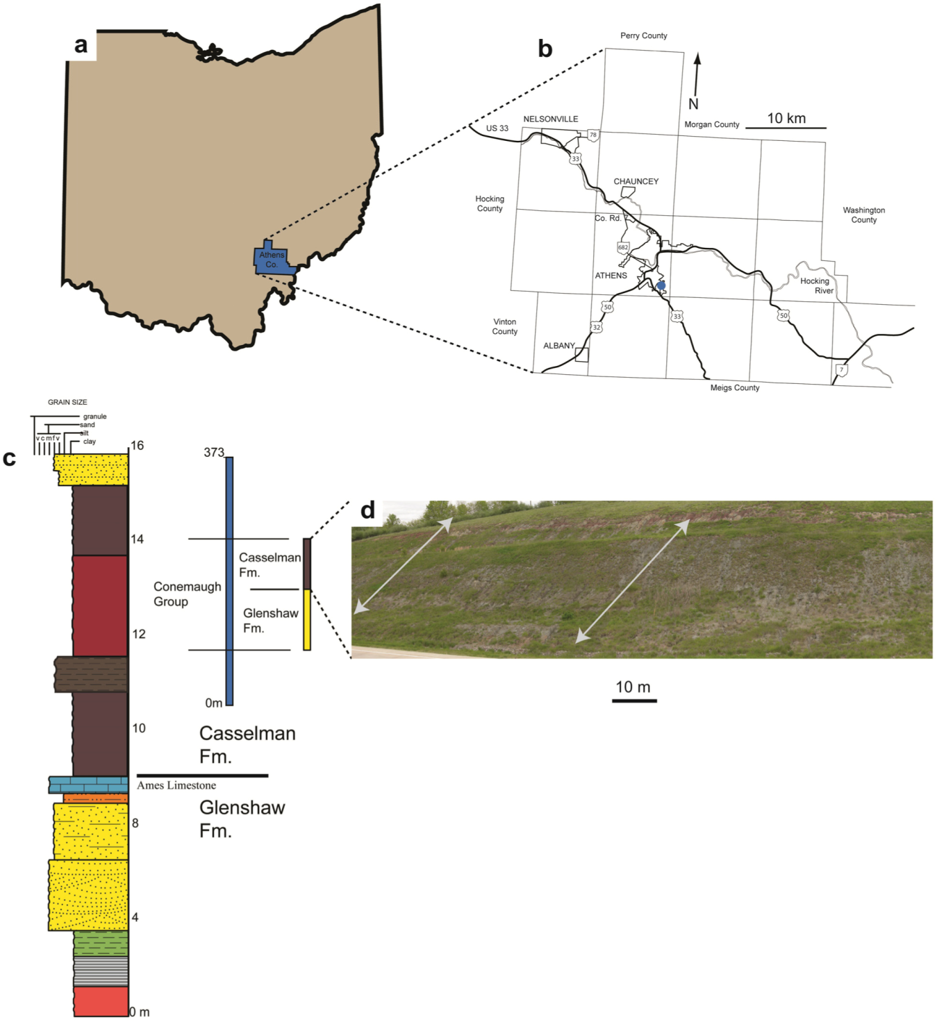
The Upper Pennsylvanian (Gzhelian, 302–300.8 Ma) Casselman Formation is the upper member of the Conemaugh Group in southeastern Ohio [34,35,36] (Figure 1). The Casselman Formation was deposited on the distal flank of the Appalachian foreland basin, which was formed in response to a succession of orogenies occurring from the Ordovician to the Permian [35,37,38,39]. Southeastern Ohio lies within the distal portion of the Appalachian basin and all exposed siliciclastic rocks present are deposits from the weathering and erosion of highlands created by overthrusting during the Alleghenian orogeny [37,40]. During the Gzhelian, the Appalachian basin was located between 5° and 15° south of the equator [17,41]. Sedimentation in southeastern Ohio occurred between the Cincinnati Arch to the west and the depo-center of the Appalachian basin to the east [13,42,43].
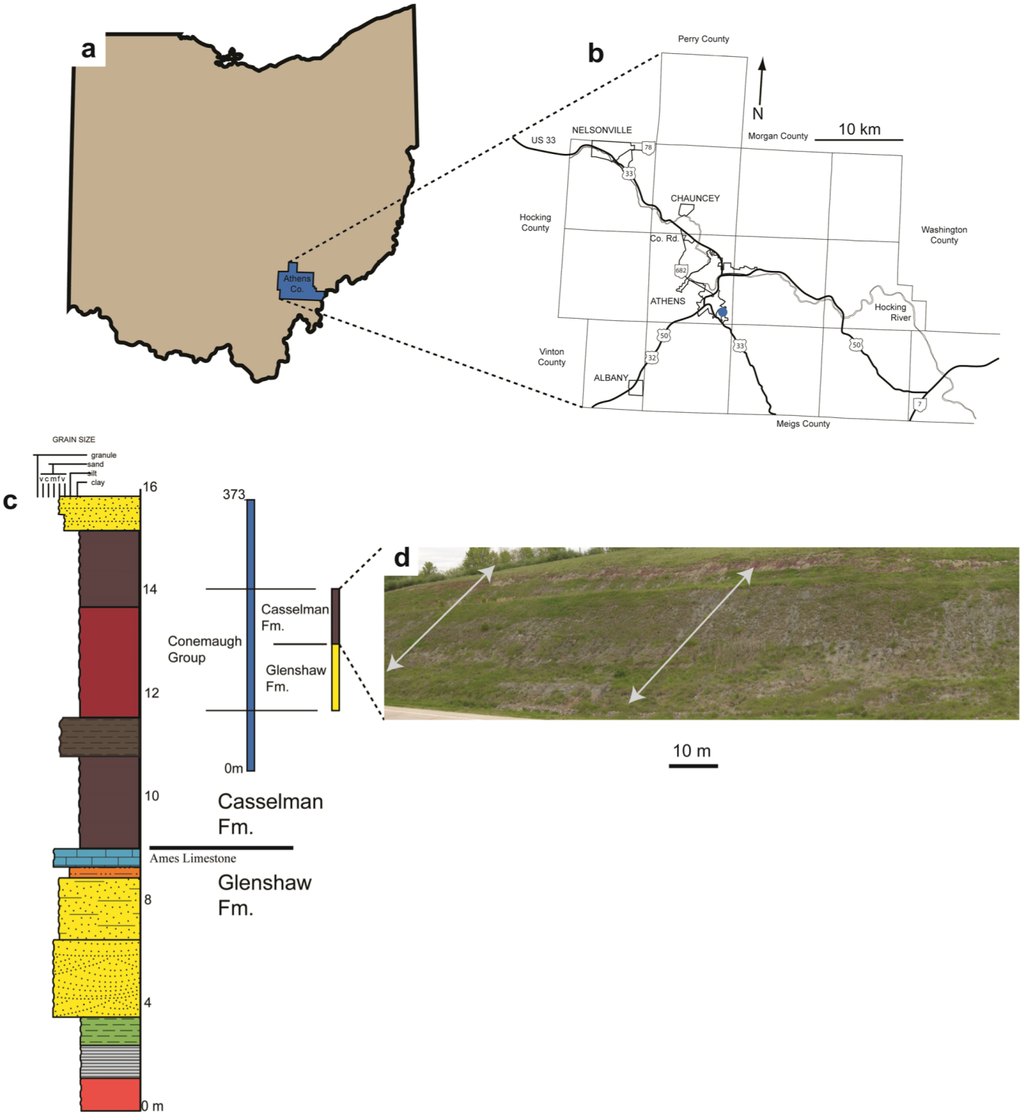
Figure 1.
(a) The location of Athens County within Ohio; (b) A map of Athens County with the location of the study area indicated by a blue dot; (c) A generalized stratigraphic section of the Conemaugh Group; (d) The outcrop of the Casselman Formation used in this study with the approximate location of Section 1 and Section 2 indicated with arrows. Modified from Hembree and Nadon [13].
Global Pennsylvanian deposition was affected by glacio-eustatic sea level fluctuations, the highest frequency of which is attributed to the waxing and waning of Gondwanan ice sheets and the accumulation of ice in the northern hemisphere [44,45,46]. It is estimated that global glacio-eustatic fluctuations of 100–120 m were common in the Late Pennsylvanian to Early Permian and data from the mid-continent demonstrates a third-order sea level rise that spans the Middle to Late Pennsylvanian [13,46,47]. The Appalachian basin was affected by fourth-order glacio-eustatic fluctuations during the Late Pennsylvanian; a combination of subsidence and long-term eustatic sea level change produced the marine units in the Conemaugh Group [45]. The instances of marine transgression decrease up-section in the Conemaugh Group. The last major marine unit of the Conemaugh Group, the Ames Limestone, occurs near the center of the group.
The major stratigraphic units of the Lower and Upper Pennsylvanian in southeastern Ohio are the Pottsville, Allegheny, Conemaugh, and the Monongahela Groups [34,36,38,48]. Outcrops of Lower and Upper Pennsylvanian strata in the Appalachian basin form a northeast-southwest elliptical belt across southeastern Ohio, eastern Kentucky, West Virginia, western Maryland and southwestern Pennsylvania [49]. Together these units have a combined thickness of 340 m and are composed of shale, mudstone, limestone, coal, and sandstone [36,48,50]. The Conemaugh Group ranges in thickness from 120 m to 270 m and is composed of siltstone, sandstone, claystone and shale; it is bounded by the Upper Freeport Coal of the Allegheny Group and the Pittsburgh Coal of the Monongahela Group [34,36,38].
The Conemaugh Group is composed of two formations, the Glenshaw and the Casselman separated by the Ames Limestone [34]. The Casselman Formation is primarily composed of cyclic sequences of shale, mudstone, siltstone, sandstone, and limestone as well as paleosols containing gilgai structures and carbonate concretions [13,36,40]. These paleosols have previously been interpreted as Vertisols and Alfisols [13]. The lithology of the Casselman Formation is markedly different from the units of the Early and Middle Pennsylvanian which are primarily composed of coal, quartz-rich fluvial sandstone, and kaolinite-rich claystone [34,40]. A change from a seasonally wet tropical paleoclimate of the Early Pennsylvanian to a seasonally dry tropical paleoclimate of the Late Pennsylvanian as well as shifts in deltaic environments has been suggested for the lithologic changes observed within these units [17,35,40,44,47,51].
The gilgai structures and high alkaline content of Late Pennsylvanian paleosols are suggested to be indicators of alternating wet periods and seasonal droughts [40,51,52,53]. It has also been suggested by Merrill [48] that the apparent increase in aridity during the Late Pennsylvanian could be due to changes in deltaic environments. Merrill [48] proposed that during the Middle and Late Pennsylvanian clastic wedges sourced from the rising Appalachian Mountains caused a shift from prodeltaic to transitional and upper delta plain environments; these upstream environments would be better drained and oxidized than the downstream environments and could partially account for the lithologic changes between the Early and Late Pennsylvanian [13,40].
3. Methods
The lowermost 20 m the Casselman Formation was studied along a well-exposed road cut located in Athens County, Ohio (Figure 1d). At this site, three 18 m vertical trenches were excavated along a 220 m transect to expose the Casselman Formation directly above the Ames Limestone. The major lithologic units of the Casselman Formation were measured and described to produce general stratigraphic sections (Figure 2). Paleosols were identified within the three sections and were then described in detail including their color, lithology, texture, grain size, sedimentary structures, mottle size and abundance, as well as the size, abundance and distribution of ichnofossils and nodules. In situ, measurements of ichnofossils in each paleosol were taken; these measurements included length, diameter, and maximum depth. The depth and types of soil horizons were documented, and individual, detailed stratigraphic columns were constructed for each paleosol (Figure 3, Figure 4 and Figure 5).
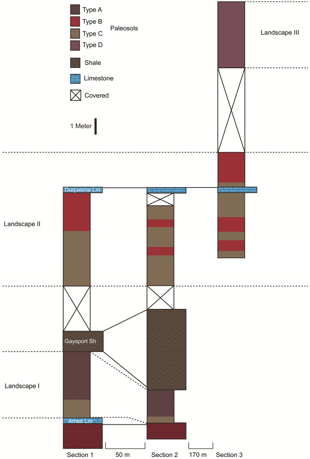
Figure 2.
Generalized stratigraphic sections of the Casselman Formation.
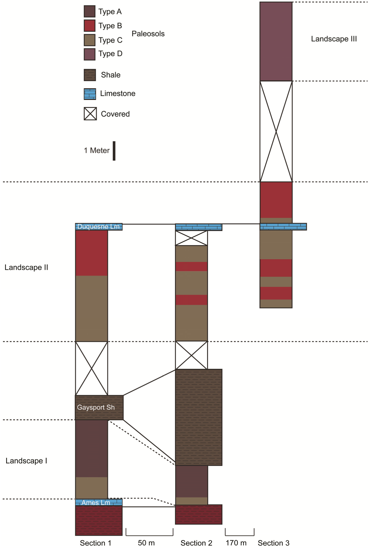
Figure 2.
Generalized stratigraphic sections of the Casselman Formation.
Paleosol samples were taken at 20 cm intervals and were used for thin section preparation. A total of 76 thin sections were prepared in a commercial laboratory (Texas Petrographic Services Inc., Houston, TX, USA) mounted on 2.5 × 5.0 cm (n = 47), 4.0 × 7.5 cm (n = 21), and 5.0 × 7.5 cm (n = 7) slides. At least one thin section was produced for each paleosol horizon. The thin sections were studied using a cross polarizing microscope (Motic BA300) to identify soil and plasmic microfabrics, glaebules, pedotubules, peds, lithic fragments, illuviated clays, and small trace fossils including rhizoliths and burrows. Micromorphological description of the thin sections follows the nomenclature of Brewer [54] and Fitzpatrick [55].
The paleosols were classified according to the descriptive system of Mack et al. [56] and were assigned an interpretive classification according to the Soil Survey Staff [57]. Ichnofossils were described according to Bertling et al. [58] and assigned to ichnogenera when possible.
4. Results
The Casselman Formation begins at the top of the Ames Limestone, which varies in exposure laterally across the outcrop. The Ames Limestone is exposed in the base of Section 1; the base of Section 2 consists of a thinly plated, 1.5 m thick, red shale unit that also underlies the Ames Limestone in Section 1 (Figure 2). The Ames Limestone is overlain by a platy gray to purple mudstone that grades vertically into 2.0–2.8 m thick blocky purple and gray claystone units that are interpreted as paleosols (Type A). Two Type A paleosols are present in Section 1 and one is in Section 2. Type A paleosols are overlain by a marine shale that laterally varies from 1.4 m to 5.2 m in thickness between the two sections (Figure 2). This marine shale forms the base of Section 3. In all three sections the shale is overlain by blocky gray claystone interpreted as paleosols (Type C). Type C paleosols vary in thickness from 0.2 m to 1.8 m and occur ten times between the three sections (Figure 2). Vertically, the Type C paleosols transition abruptly into 2.0–3.6 m thick blocky red claystone units also interpreted as paleosols (Type B). Type B paleosols occur seven times between the three sections. In all three sections, the Type B and Type C paleosols vary both vertically and laterally in thickness and in the number of times the units are exposed. A 0.3 m thick non-marine limestone unit caps Section 1 and Section 2 and crops out midway through Section 3 (Figure 2). Approximately 5 m of the upper (9 m) portion of Section 3 is covered by modern vegetation and slump. Above the covered portion of Section 3 is a blocky purple claystone interpreted as a paleosol (Type D) that consists of two separate, stacked paleosol profiles with a combined thickness of 4.2 m (Figure 2).
The shale unit separating the Type A paleosols from the Types B and C paleosols is interpreted as the Gaysport Shale Member of the Gaysport Cyclothem based on its lithology, thickness and stratigraphic position [34]. The thickness of the Gaysport Shale has been noted to range from 1.5 m to 8.3 m within Athens County; because of this the change in the thickness of the shale unit within the study area is not considered abnormal [34]. The limestone unit that caps the Types B and C paleosols in Section 1 and Section 2 and crops out partway through these paleosols in Section 3 is interpreted as the freshwater Duquesne Limestone Unit of the Duquesne Cyclothem [34]. This interpretation is based on the thickness of the Duquesne Limestone (~0.5 m), the few, small ostracode fossils within the unit, and its stratigraphic relationship to the Types B and C paleosol sequences that are referred to as “red beds” and gray “underclays” by Sturgeon [34].
4.1. Continental Ichnology of the Casselman Formation
Back-filled Burrows: Unlined, backfilled, subvertical, unbranched or bifurcated shafts are present in the Type A paleosols (Figure 3). The burrows are between 1 mm and 3 mm wide with an observed length of up to 1.5 cm; however, the originations of the burrows are not preserved. The shafts are filled with brown to yellow claystone that is distinct from the surrounding purple matrix in which they are preserved. The backfilled burrows are assigned to the ichnogenus Taenidium [59] and are interpreted as deposit-feeding structures of small soil arthropods [60]. These trace fossils are similar in morphology to burrows produced by cicada nymphs (Cicadetta calliope) in well-drained soil environments [32].
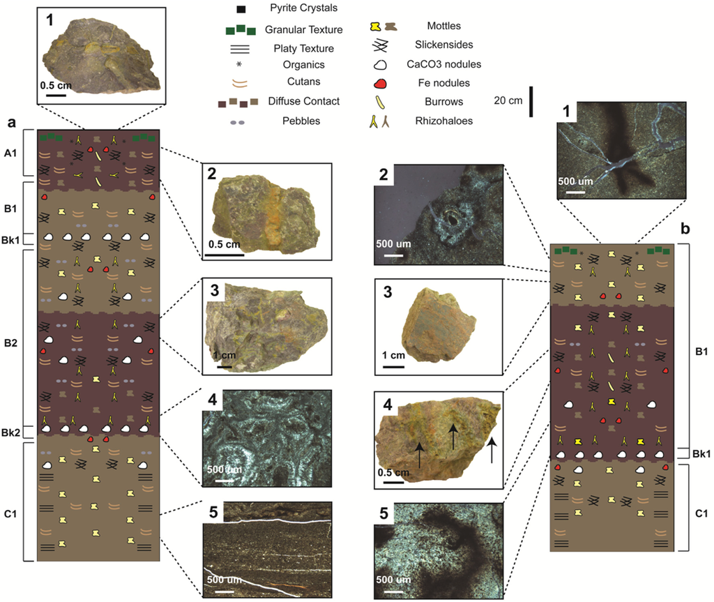
Figure 3.
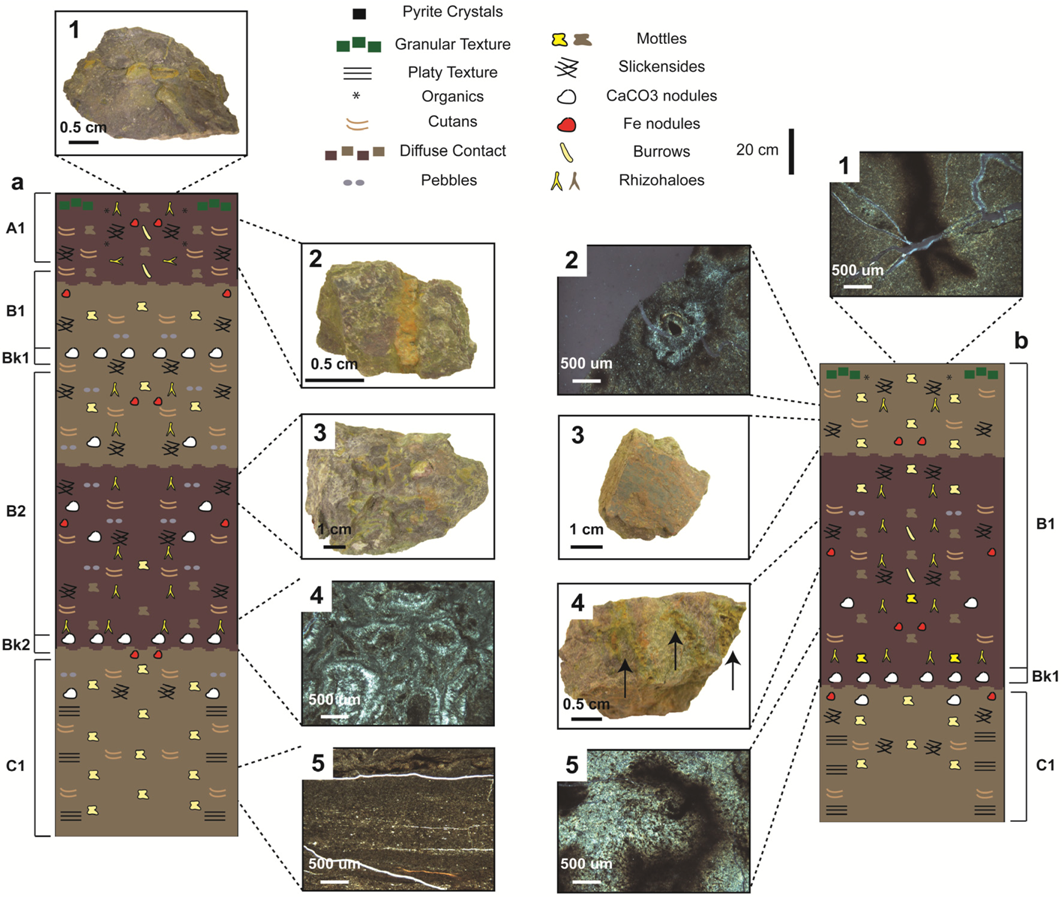
(a) Composite Type A paleosol; dashed lines show the approximate location of hand samples and thin sections shown within the soil columns: (1) Horizontal rhizohaloes; (2) Backfilled burrow; (3) Branching, vertical rhizohaloes; (4) Thin section of a Bk horizon with coalescing carbonate nodules; (5) Thin section of a C horizon with an argillasepic plasmic microfabric. (b) Cumulative Type A paleosol: (1) Thin section a branching, vertically oriented rhizohalo; (2) Cross section of a rhizohalo with an organic core; (3) Slickenside covering the surface of a hand sample; (4) Multiple vertically oriented backfilled burrows (at arrows); (5) Thin section of a rhizohalo surrounded by small iron nodules.
Rhizohaloes: Rhizohaloes are root traces that result from interactions between soils, roots, and microorganisms [11,20]. Roots and microorganisms both produce organic compounds that preferentially reduce the pedogenic iron and manganese within the area of the soil adjacent to the root [11,20]. Paleosol Type A, B and D commonly contain elongate yellow and gray branching vertically oriented rhizohaloes. Type C paleosols contains rare elongate yellow rhizohaloes (Figure 4b). The Type A, B and D paleosols typically contain two size distributions of rhizohaloes in both hand sample and thin section; smaller 0.5–5.0 mm rhizohaloes and larger rhizohaloes that range in diameter from 1 cm to 3 cm. Both sizes of rhizohaloes are commonly circular to elliptical in cross section (Figure 3b and Figure 4b). Individual rhizohaloes are typically uniform in color; less commonly the rhizohaloes are either black in the center or have centers that are the same color as the surrounding claystone (Figure 3, Figure 4 and Figure 5). Type A paleosols also contain rare horizontally oriented yellow rhizohaloes with black, organic-filled centers (Figure 3b).
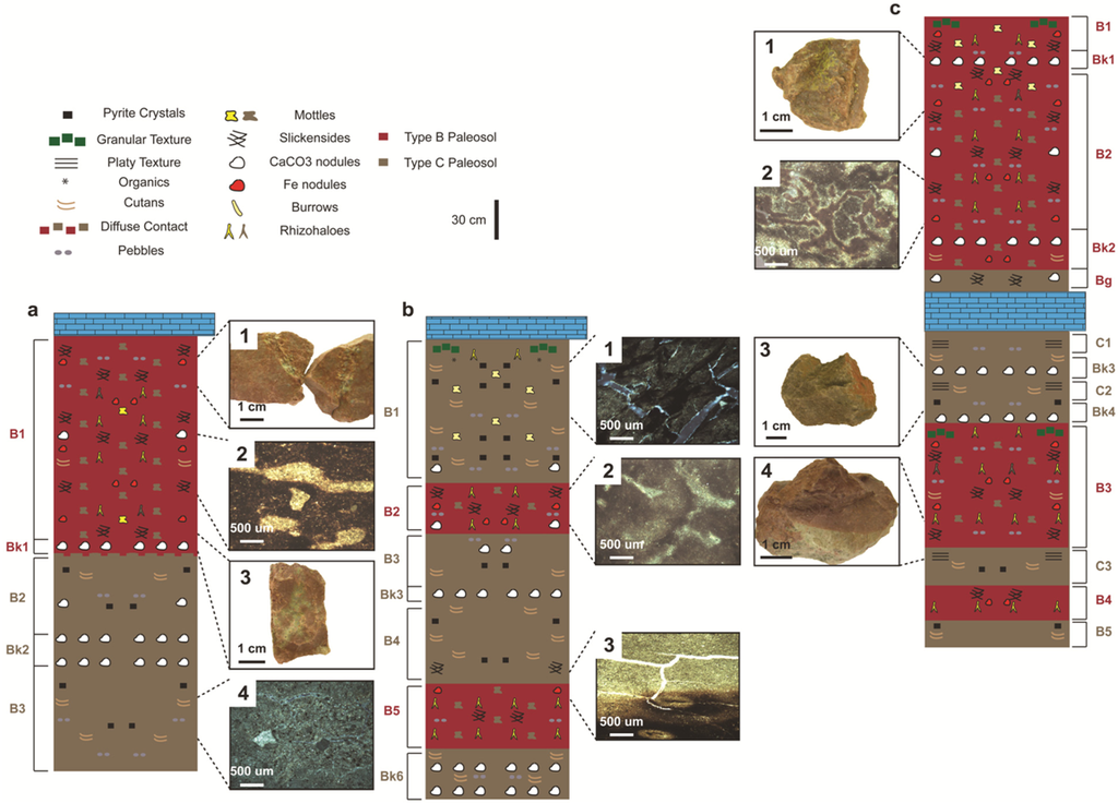
Figure 4.
(a) Type B and C paleosols from Section 1: (1) Clastic-filled fracture in a Type B paleosol; (2) Sharp-walled rhizohaloes from a Type B paleosol; (3) Branching vertically oriented gray mottle from a Type B paleosol; (4) Thin section of a Type C paleosol with an insepic plasmic microfabric, a small carbonate nodule, and pyrite crystals. (b) Type B and C paleosols from Section 2: (1) Vertically oriented rhizohaloes from a Type C paleosol; (2) Diffuse rhizohaloes from a Type B paleosol; (3) Thin section of the sharp boundary between a Type B paleosol and the overlying Type C paleosol with cross sections of rhizohaloes from the Type B paleosol. (c) Type B and C paleosols from Section 3: (1) Fine-scale, branching, vertically oriented, yellow rhizohalo from a Type B paleosol; (2) Thin section of branching rhizohaloes from a Type B paleosol with local gleization; (3) Typical sample of gray claystone with brown cutans from a Type C paleosol; (4) Hand sample of the sharp boundary between a Type C paleosol and the overlying Type B paleosol.
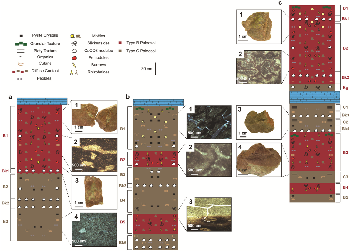
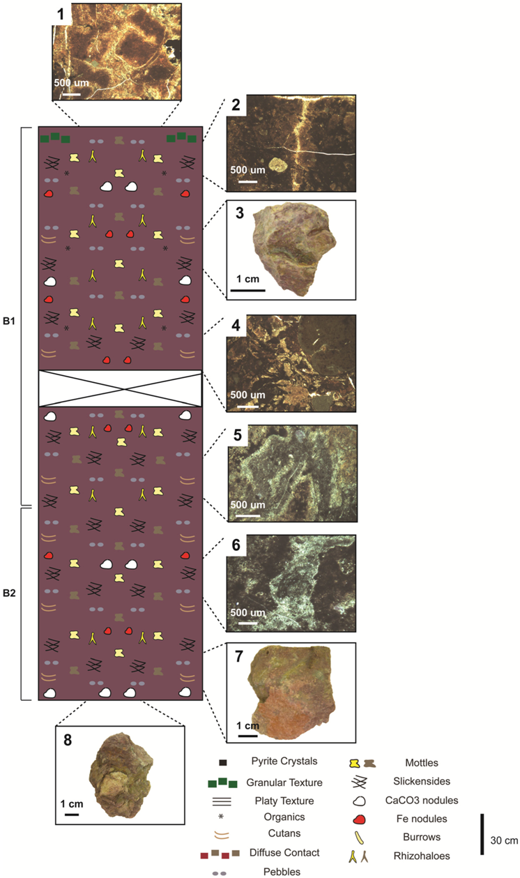
Figure 5.
Type D paleosols: (1) Small peds that indicate the soil surface; (2) Thin section of a vertically oriented rhizohalo and a small carbonate nodule; (3) Hand sample with a vertically oriented gray rhizohalo; (4) Thin section of a small carbonate nodule and a large complex nodule with an iron center and a carbonate rim; (5) Thin section of a branching, vertically oriented rhizohalo; (6) Amorphous gray mottle; (7) Hand sample with a brown cutan and a vertically oriented yellow mottle; (8) Hand sample with a carbonate nodule from the base of a Type D paleosol.
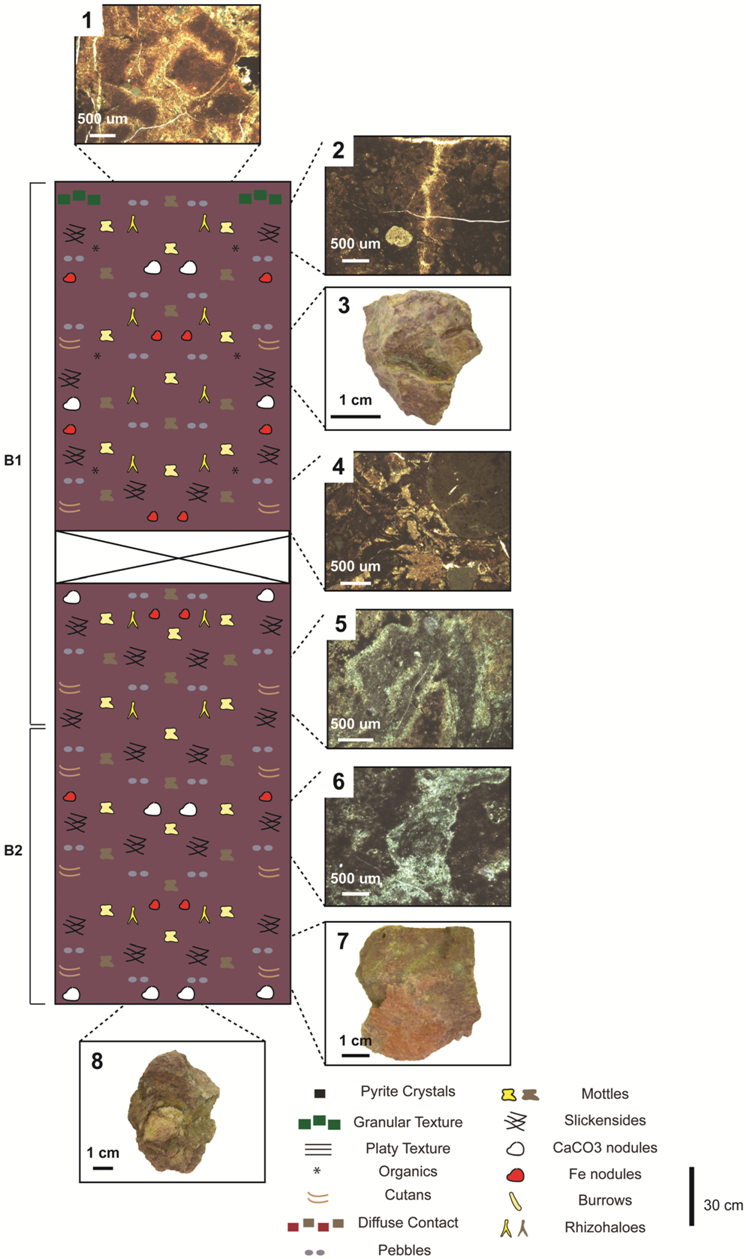
Mottles: Paleosol Types A, B and D commonly contain unbranched amorphous yellow and gray mottles that occur throughout the paleosol profiles and typically range in diameter from 1 cm to 4 cm in hand sample and 0.3–0.7 cm in thin section. Type C paleosols contain rare yellow mottles that are both millimeter- and centimeter-scale. The mottles typically have a combination of sharp to gradational boundaries (Figure 3b, Figure 4a, Figure 4b, Figure 5 and Figure 6b). These mottles are interpreted to be the result of organism-substrate interactions that modified areas of the soil profile. Amorphous biogenically produced mottles similar to those found within the paleosols of the Casselman Formation can form in a variety of ways. The reduction and mobilization of iron within the rhizosphere during periods of reducing conditions can produce drab colored mottles around roots [11,20]. Zones of increased porosity and permeability produced by deposit feeders allow for the preferential movement of water through the soil profile; this leads to localized areas of gleization [61]. Amorphous yellow and gray mottles can also be produced by the metabolic activity of bacteria; the bacterial consumption of organic matter such as the fecal material produced by deposit feeders creates reducing conditions within the soil [20]. Due to the variety of ways in which amorphous mottles can be produced the potential tracemakers are unknown; however, the morphology of the mottles indicates that they are biogenic in origin. Regardless of the exact tracemaker, the presence of amorphous mottles within paleosols indicates the soil environment was moderately to well drained, at least periodically moist, and organic rich [62].
4.2. Paleopedology of the Casselman Formation
4.2.1. Type A Paleosols
Description: Type A paleosols (n = 3) occur below marine shale and are 2.0–2.8 m thick (Figure 2 and Figure 3). Type A paleosols are characterized by well-defined soil horizons that are composed of a solid to variegated dark purple (10R 3/1) to gray (7.5YR 5/1) claystone with an angular blocky texture. The contacts between the dark purple claystone and the gray claystone are gradational. The color of the purple claystone is strongest in the upper and middle portions of the profiles and becomes more variegated toward the base of the profiles. Individual angular blocks of claystone are covered by clay skins and slickensides (Figure 3b); the blocks are typically 4–7 cm in diameter and often contain intraclasts in the form of coarse-grained sand to subrounded rock fragments that average 2 mm in diameter. Carbonate nodules 3–7 cm in diameter are either dispersed throughout the profiles or are concentrated in 10 cm thick layers. Vertically oriented and horizontally branching yellow and gray mottles are present throughout the profiles. Type A paleosols occur as a single, thick profile or as multiple, overlapping, stacked profiles (Figure 3).
The ichnofossil assemblage associated with Type A paleosols is dominated by yellow, vertically oriented, branching rhizohaloes that occur throughout the profiles (Figure 3a). Other ichnofossils present in the upper 80 cm of the paleosols are vertically oriented, branched and unbranched backfilled burrows (Figure 3).
In thin section, Type A paleosols are composed of plasma, nodules, and mineral grains. The micromorphology is characterized by a porphyroskelic microfabric and a mixture of sepic microfabrics including insepic, mosepic, and argillasepic (Figure 3a and Figure 6). Localized layers of high birefringence clay are also common in the samples (Figure 6a). Biological features include gray, brown and yellow rhizohaloes that range in width from 300 µm to 700 µm (Figure 6b) as well as larger amorphous gray mottles that range in width from 900 µm to 3500 µm (Figure 6c). Approximately 25% of the rhizohaloes have cores composed either of organic material or calcite spar (Figure 3b and Figure 6b). Small (50–150 µm) pyrite crystals as well as small (20–80 µm) iron nodules are common throughout the samples although the nodules occur primarily around root traces (Figure 3b). Carbonate nodules (300–2400 µm) are also present in the samples. These are generally larger and more abundant than the iron nodules. Thin sections of large (1–3 cm) carbonate nodules show that many smaller nodules typically coalesced to form the larger nodules (Figure 3a).

Figure 6.
Plasmic microfabrics from the Type A paleosols: (a) A patch of high birefringence clay within a matrix of insepic plasmic microfabric; (b) An insepic microfabric with local gleization around a rhizohalo; (c) A mosepic plasmic microfabric.
Figure 6.
Plasmic microfabrics from the Type A paleosols: (a) A patch of high birefringence clay within a matrix of insepic plasmic microfabric; (b) An insepic microfabric with local gleization around a rhizohalo; (c) A mosepic plasmic microfabric.

Interpretation: The Type A paleosol in Section 1 represents an A horizon, two stacked B horizons, and an underlying C horizon (Figure 3a). The Type A paleosol in Section 2 represents one individual profile composed of a single, over-thickened B horizon and an underlying C horizon (Figure 3b). The C horizon consists of partially modified mudstone with moderate to weak millimeter-scale lamination. The occurrence of overlapping stacked profiles in Section 1 is indicative of a composite paleosol; while the occurrence of a thick individual profile in Section 2 is indicative of a cumulative paleosol [8].
Composite paleosols are formed when the rate of pedogenesis is not steady because it is interrupted by periodic episodes of high rates of deposition [8,63]. These depositional events bury the active soil surface beyond the reach of pedogenesis. Over time, however, ensuing development of the overlying active soil extends into the buried paleosol, which results in partially overlapping and vertically successive profiles that have a combination of pedogenic features from the overlying and underlying soils [8,13,63]. The composite Type A paleosol consists of two stacked paleosols separated by a carbonate accumulation horizon (Bk) (Figure 3a). Cumulative paleosols, in comparison, are produced under steady pedogenic conditions when the rate of sedimentation is low but continuous or when the rate of erosion is insignificant [8]. The rate of pedogenesis keeps pace with the rate of sedimentation producing over-thickened B horizons with a uniform vertical distribution of root traces and mottles as the soil aggrades slowly over time. Cumulative paleosol profiles, therefore, record the average environmental conditions during pedogenesis [8,19].
Due to the presence of pedogenic carbonate nodules and Bk horizons, organic matter, clay skins on hand samples, illuviated clay observed in thin sections and hand samples, along with slickensides, Type A paleosols are classified as calcic vertic Argillisols [56] and interpreted as Alfisols [57]. The slickensides present in Type A paleosols suggest shrink-swell processes [20,56]. These features may also be present in Vertisols; however the Type A paleosols lack other diagnostic features of Vertisols such as wedge-shaped peds and hummock and swale structures [20,56]. The abundance of clay skins and the presence of oriented clay in thin sections are strong indicators of Alfisols [20,56].
The ichnofossils preserved in the Type A paleosols represent a lush vegetative community in a seasonal environment. Based on their distribution and morphology, the branched, deeply penetrating rhizohaloes and the small-scale rhizohaloes present in the upper portions of the B horizons were each likely formed by different types of plants [20]. The smaller rhizohaloes may represent ground-covering plants, while the larger rhizohaloes may represent larger tree-like plants [64,65]. In the composite Type A paleosols, the larger branched rhizohaloes also occur alongside un-branched horizontal rhizohaloes that occur in the uppermost portion of the paleosols. The combination of horizontally and vertically oriented rhizohaloes is typically a good indicator of a periodically high water table [20]. Because roots respire aerobically they do not grow far below the water table; thus roots in waterlogged soils will spread out laterally while roots in well-drained soils will penetrate the soil column more deeply and branch vertically [20]. The backfilled burrows in the Type A paleosols suggest the presence of mobile deposit-feeding soil animals in an oxygenated environment [60,62]. The high concentration of these burrows in hand samples from areas in the Type A paleosols suggest that an abundance of organic matter was present throughout the soil profile and not just in the preserved A horizon [60,62].
Moist soil conditions are indicated in the Type A paleosols by the gleyed horizons as well as the illuviated clay in thin section, which is caused by the movement of water through the soil profile. Seasonal variation in moisture content is indicated by the isolated calcareous nodules and the calcareous horizons, which are formed by the alternation of oxidizing and reducing conditions within the zone of water-table fluctuation [11,20]. The combined presence of gleization, shrink-swell features, deep penetrating roots, horizontal roots, and calcareous nodules indicates seasonal fluctuations in soil moisture regimes [20]. Type A paleosols were therefore likely well-drained soils with a seasonally perched water table [11,20].
4.2.2. Type B Paleosols
Description: Type B paleosols (n = 7) occur either below a non-marine limestone unit or other paleosol units and are 2.0–3.6 m thick (Figure 4). Type B paleosols are a uniform dark red (10R 4/6) claystone with an angular blocky texture. Individual angular blocks are commonly covered by clay skins and slickensides. Vertically oriented, horizontally branching yellow and gray mottles (0.3–3.0 cm wide) are present throughout Type B paleosols. Intraclasts in the form of coarse-grained sand to clusters of subangular rock fragments ranging from 1 mm to 3 mm in diameter are common within the individual blocks of claystone. Pebble-filled fractures are also present (Figure 4a). Carbonate nodules ranging in diameter from 3 cm to 10 cm are either infrequently dispersed within the paleosols or occur in 10 cm thick layers. One Type B paleosol occurs as a stacked profile whereas all other Type B paleosols occur as single profiles (Figure 4).
In thin section, Type B paleosols are composed of plasma, nodules, and mineral grains. The micromorphology is characterized by porphyroskelic to agglomeroplasmic microfabrics and insepic and mosepic plasmic microfabrics (Figure 7). Localized patches of high birefringence clay and localized gleization around fractures, nodules and grains are common (Figure 7). Biological features include sharp to diffuse gray and brown rhizohaloes and amorphous mottles (Figure 4 and Figure 7c). Small (200–400 µm) ostracode shell fragments are also present in several of the samples. Red iron oxide staining is abundant throughout the samples; small (200–900 µm) iron nodules and pyrite crystals also occur commonly and irregularly throughout the samples. Small (500–1600 µm) carbonate nodules are also common throughout the thin sections. These nodules are micritic with spar filling internal fractures and voids. Pyrite crystals (30–170 µm) are common in thin sections of large (1–3 cm) carbonate nodules. Thin sections of large, individual carbonate nodules show that they are composed of several coalesced nodules.

Figure 7.
Microfabrics from Type B paleosols: (a) An agglomeroplasmic soil microfabric; (b) An insepic plasmic microfabric with local gleization around an iron nodule; (c) Vertically-oriented rhizohaloes and a mosepic plasmic microfabric.
Figure 7.
Microfabrics from Type B paleosols: (a) An agglomeroplasmic soil microfabric; (b) An insepic plasmic microfabric with local gleization around an iron nodule; (c) Vertically-oriented rhizohaloes and a mosepic plasmic microfabric.

Interpretation: Five individual and two overlapping stacked B horizons are represented by the Type B paleosols. The stacked B horizons occur in the middle portion of Section 3 (Figure 4c) whereas the individual B horizons occur in the upper portions of Section 1 and Section 2 as well as in the lower portion of Section 3 (Figure 4). A composite paleosol is indicated by the overlapping stacked profiles [8]. The two B horizons of the composite Type B paleosol are separated by a Bk horizon (Figure 4c).
Type B paleosols are classified as ferric calcic vertic Argillisols [56] and interpreted as Vertisols [57] due to the abundance of iron in thin section, the deep pedogenic carbonate nodules and Bk horizons, and the predominance of shrink-swell features. Shrink-swell features such as slickensides and illuviated clay may be present in other soil orders, but these features combined with the clastic-filled, wedge-shaped cracks present in the Type B paleosols are strong indicators of Vertisols [56,57].
A diverse but patchy vegetative cover and fluctuating moisture regimes are represented by the ichnofossils present in the Type B paleosols. The larger, centimeter-scale rhizohaloes and the smaller, millimeter-scale rhizohaloes were likely each produced by different types of plants. The millimeter-scale rhizohaloes could represent small, ground covering plants that could tolerate fluctuating moisture regimes; the larger rhizohaloes could represent tree-like plants [20,64,65]. Roots of most plants do not extend far below the water table; because of this the small-and medium-sized rhizohaloes in the Type B paleosols indicate a periodically high water table [20]. The occurrence of both yellow and gray mottles and rhizohaloes together also indicates the Type B paleosols experienced fluctuations in moisture conditions [11,20]. The yellow rhizohaloes are suggestive of the formation of goethite over hematite [11]. This, combined with the abundance of pedogenic iron, which is precipitated during redox cycles, indicates the soil profile was oxidized and moderately well drained [11,22,66]. Gray rhizohaloes are formed when a soil is saturated with water and depleted in oxygen. Under anoxic conditions iron is reduced and removed from these areas of the soil matrix; thus the gray rhizohaloes indicate periods of soil saturation [11]. The clusters of pebbles suggest that periodic flooding events are partially responsible for these fluctuations in soil moisture.
4.2.3. Type C Paleosols
Description: Type C paleosols (n = 10) occur either below Type B paleosols or non-marine limestone and are 0.2–1.8 m thick. Type C paleosols are characterized by a uniform gray-colored (2.5YR 6/1) claystone and sharp contacts with adjacent units. The texture of the individual blocks varies from subangular to spherical. The individual blocks of claystone are occasionally covered by clay skins, which rarely possess slickensides, and average between 2 cm and 7 cm in diameter. Intraclasts in the form of 1–3 cm diameter subangular rock fragments are common in the individual blocks. Vertically oriented and horizontally branching yellow mottles are present in the upper portion of one Type C paleosol profile in Section 2 (Figure 4b). Carbonate nodules ranging in diameter from 2 cm to 10 cm are both infrequently dispersed throughout the paleosols and occur in 10 cm thick layers. A massive 35 cm thick non-marine carbonate unit also occurs within one Type C paleosol at the boundary with a Type B paleosol. The Type C paleosols represent individual and stacked B horizons as well as individual C horizons and C horizons that underlie B horizons (Figure 4c).
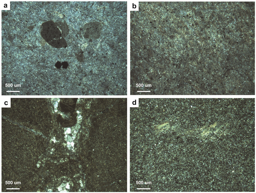
In thin section Type C paleosols are composed of plasma, nodules, and mineral grains. The micromorphology is characterized by a porphyroskelic and a rarely agglomeroplasmic microfabric (Figure 8). The plasmic microfabric of the Type C paleosols is a mixture of sepic and asepic microfabrics including insepic, mosepic and calciasepic (Figure 4a and Figure 8). Small, localized patches of high birefringence clay are common in the samples (Figure 8d). Biological features include brown rhizohaloes that are present in the thin sections from the uppermost portion of Section 2 (Figure 4b). Small (17–330 µm) pyrite crystals and small (100–1400 µm) micritic carbonate nodules are also common throughout the samples.
Interpretation: The Type C paleosols represent multiple isolated and stacked B horizons as well as isolated C horizons, which consist of partially modified mudstone with moderate to weak remnant platy bedding. The stacked B horizons occur in the upper portion of Section 1 and Section 2 (Figure 4a,b) whereas the isolated B and C horizons occur in the lower portion of Section 3 (Figure 4c). A composite paleosol is indicated by the overlapping stacked profiles, the B horizons of which are separated by Bk horizons [8] (Figure 4c).
Due to the homogenous gray claystone present in the paleosol profile, as well as the abundance of carbonate accumulations in association with reduced iron, the Type C paleosols are classified as calcic Gleysols [56] and interpreted as Inceptisols [57]. Although the Type C paleosols exhibit several shrink-swell features such as weak slickensides, clay skins, as well as rare patches of oriented clay in thin section, these features are not well developed enough to classify the paleosols as Vertisols, which commonly have wedge-shaped peds and abundant well-developed slickensides, or Alfisols, which typically have horizons of illuviated clay [22,56,57]. The Type C paleosols are also beyond the developmental stage of Entisols.
The wet-to-waterlogged conditions necessary to produce a Gleysol likely overprinted most biogenic features present in the paleosols and excluded most plant species, and burrowing animals because oxygenated conditions are required for aerobic respiration. The time of formation of Inceptisols is also relatively short (101–102 years); it is therefore likely that the relative absence of soil biota in the Type C paleosols may also be due to inadequate colonization time [20]. The only rhizohaloes and mottles observed in the hand samples and thin sections from the Type C paleosols occurred in the top of one profile in Section 2 (Figure 4b). The observation of these features in the upper-most portion of some profiles suggests that it is possible that these features occurred in a higher topographic area and were not overprinted by a rise in the water-table.
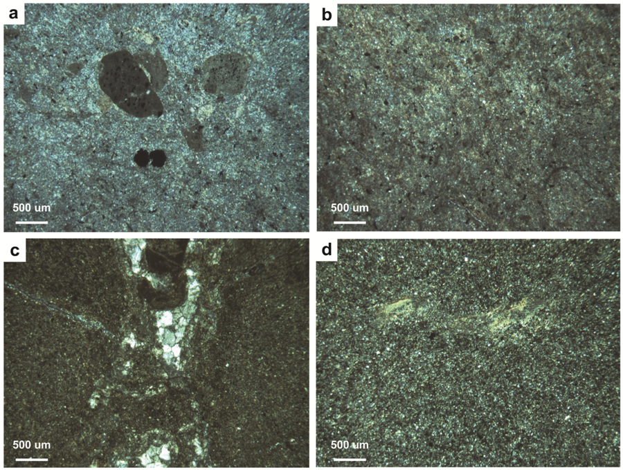
Figure 8.
Microfabrics from Type C paleosols: (a) An agglomeroplasmic soil microfabric; (b) An insepic plasmic microfabric with small pyrite crystals within the matrix; (c) A calciasepic soil microfabric surrounding a fracture that is filled with calcite spar; (d) A high birefringence streak of clay within a mosepic plasmic microfabric.
4.2.4. Type D Paleosols
Description: Two Type D paleosols (n = 2) overlie an area that is covered with modern slump and vegetation (Figure 2). Cumulatively the two Type D paleosols are 4.2 m thick. The Type D paleosols are characterized by a uniform to variegated, angular blocky, purple (10R 4/3) claystone with no primary sedimentary structures. The purple background color is consistent throughout the profile. Vertically oriented and horizontally branching yellow and gray mottles (0.3–4.0 cm wide) are present throughout the Type D paleosol (Figure 5). Individual blocks of the paleosol range in size from 3 cm to 9 cm in diameter, and are often covered with clay skins and slickensides. Intraclasts in the form of coarse-grained sand to clusters of subangular rock fragments ranging from 1 mm to 3 mm in diameter are frequently observed in the claystone blocks. Carbonate nodules ranging in diameter from 1 cm to 3 cm were found infrequently dispersed throughout the paleosols and clustered within the lowermost portion of the paleosol. The Type D paleosols occur as two overlapping and over-thickened profiles.
In thin section, the Type D paleosols are composed of plasma, nodules, and mineral grains including quartz and feldspar. The microfabric ranges from agglomeroplasmic to porphyroskelic; the plasmic microfabric is commonly insepic and skelsepic (Figure 5 and Figure 9). The texture of the Type D paleosols is coarser than that of the other three Casselman paleosol types. Peds are commonly visible in thin section and range in size from 0.6 cm to 1.1 cm. The peds are most distinct in two horizons; at 0–20 cm and 320–340 cm (Figure 5). Cracks and voids within the samples are commonly filled with oriented clay and are less commonly filled with calcite spar (Figure 4). Biological features include gray and brown rhizohaloes (Figure 4). Small (100–500 µm) shell fragments and rare complete ostracode fossils are present throughout the samples (Figure 9b). Small (100–2400 µm) iron nodules, carbonate nodules, and complex nodules that contain both carbonate and iron occur throughout the samples (Figure 4 and Figure 9a). The carbonate nodules and the complex nodule types commonly occur together within the samples.

Figure 9.
Microfabrics from Type D paleosol: (a) An agglomeroplasmic soil microfabric; (b) A small ostracode fossil within an insepic plasmic microfabric; (c) An insepic plasmic microfabric with local gleization around a fracture.
Figure 9.
Microfabrics from Type D paleosol: (a) An agglomeroplasmic soil microfabric; (b) A small ostracode fossil within an insepic plasmic microfabric; (c) An insepic plasmic microfabric with local gleization around a fracture.

Interpretation: The Type D paleosol represents two over-thickened B horizons. Thick, homogenous, cumulative paleosols indicate steady sedimentation rates along with steady rates of pedogenesis and insignificant rates of erosion [8]. Cumulative paleosols such as the Casselman Type D paleosol thus record the average environmental conditions during active pedogenesis [8,19]. Within the paleosol profile, the two cumulative Type D paleosols are separated by horizons that contain distinct peds that represent the active soil surface [20].
Due to the homogenous nature of the paleosol profile as well the presence of shrink-swell features in the form of slickensides, the patches of oriented clay, and the presence of carbonate nodules in thin section, the Type D paleosols are classified as vertic Argillisols [56] and interpreted as vertic Alfisols [57]. The Type D paleosols exhibit development beyond that of an Inceptisol, but the development is less than that of an Oxisol. These paleosols also have shrink-swell structures associated with Vertisols, but do not exhibit other indicators of Vertisols, which include hummock and swale topography and wedge-shaped peds [20,56].
The ichnofossils of the Type D paleosols represent a diverse assemblage of flora within the soil environment. The abundant large, branching, vertically oriented rhizohaloes throughout the paleosol profile likely represent tree-like plants, while the small-scale roots could represent smaller, ground covering plants [64,65,67]. The presence of small carbonate nodules and the intermingling of both gray and yellow rhizohaloes indicate fluctuations in moisture and therefore redox conditions. The gray rhizohaloes indicate iron depletion in response to soil saturation and oxygen depletion [11,20]. The presence of yellow rhizohaloes in the hand samples and the presence of iron nodules in the thin sections indicate that the soil profile was also oxidized and well drained at times [11,66]. The fluctuations in moisture conditions could have been caused by a combination of seasonality and periodic flooding events, which are indicated by the siliciclastic input throughout the paleosol profile. The lack of gleyed horizons suggests that the increases in soil moisture in the Type D soils were not as frequent or large as those that occurred in the Type A soils [20].
5. Discussion
The paleosols and ichnofossils from the Casselman Formation of southeastern Ohio record important paleoecologic, paleotopographic, and paleoclimatic data that allow for the reconstruction of soil environments within the Appalachian basin during the middle portion of the Late Pennsylvanian. The data collected in this study are not only valuable for the interpretation of the localized vertical and lateral variations that occur within these paleosols as a result of changes in topography and hydrology, but are also important for understanding the effects that long-term changes in climate and eustasy have on pedogenic processes.
5.1. Casselman Landscapes
The paleosols of the Casselman Formation represent three different landscape surfaces. Important details concerning the soil environments and ecologies of these landscapes are recorded by the four unique pedotypes. The four pedotypes of the Casselman Formation correspond to the variations in lithofacies, topography and drainage conditions that are present in alluvial systems. The pedotypes also correspond to the climatic transition that occurred during the Late Pennsylvanian.
Landscape I: The Type A paleosols are typical of modern soils formed in a vegetated distal floodplain. Due to the periodic input of sediment, soils formed on distal floodplains are immature to moderately mature and commonly lack clearly developed profiles [19,68]. Flooding events are indicated by localized gleization and siliciclastic input in the form of coarse sand and rock fragments. It is likely that the composite profile of one of the Type A paleosols is the result of the sediment input from a flooding event burying the active soil surface. While it is likely that flooding had at least a minor influence on the pedogenesis of the Type A paleosols, seasonal fluctuations in soil moisture likely had a stronger pedogenic influence.
Shrink-swell features, the combination of horizontal and deeply penetrating vertical rhizohaloes, the gleyed horizons, and the calcareous nodules and horizons are indicative of wooded grassland in a sub-tropical to tropical seasonal wet-dry environment [20,21]. The surface horizons of wooded grasslands also tend to have organic accumulations and granular textures whereas the subsurface is moderately calcic [20]; all of these features are present in the composite Type A paleosol (Figure 2 and Figure 3). Although grasses were not present in the Pennsylvanian, a variety of ground covering vegetation, such as ferns and herbaceous lycopods, were present [62,67].
Based on the composite and cumulative paleosol profiles, the amount of clay in the subsurface, and the development of carbonate horizons, the time of formation for the Type A paleosols was likely between 102 years and 103 years [20]. The pedogenic development of Argillisols typically spans 102–104 years; however, high amounts of precipitation can increase the rate of pedogenesis [20].
The back-filled burrows are interpreted as feeding structures produced by detritivores and are classified as Taenidium. A soil with abundant organic matter such as wooded grassland would be able to support the density of the back-filled burrows present in some samples from the Type A paleosols [20]. Modern neoichnological studies suggest that back-filled feeding structures similar to those found in the Type A paleosols were likely produced by soil arthropods [32].
Landscape II: Type B and Type C paleosols have properties that are typical of modern soil formation in alluvial swamp successions. The drainage conditions in alluvial swamp successions repeatedly change; this results in soil with contrasting features that frequently overprint and truncate each other [68]. During persistent alluvial swamp sedimentation in topographically low areas, the water table is permanently at or above the sediment surface. This condition produced the Type C paleosols, which are gleyed, reduced, and pyrite-rich [20,56,68]. Since the alternation of oxidizing and reducing conditions within the zone of water table fluctuation produces nodules, the individual carbonate nodules and the Bk horizons present in the Type C paleosols (Figure 2 and Figure 4) are also evidence of the maximum depth of the water table [20]. The lack of significant organic accumulations such as peat within the Type C paleosols could indicate that either there was a lack of plant biomass within the soil environment or that the water-logged conditions did not last long enough for the organics to accumulate and were instead oxidized during drier conditions [20]. Due to their lack of pedogenic development, a time span of 101–102 years is interpreted for the formation of Type C paleosols.
The build-up of sediment from localized flooding events into some areas of the alluvial swamp likely caused the development of better-drained, higher (1–5 m) topographic areas with a correspondingly deeper water table [68]. Type B paleosols likely formed in these types of areas. The red coloration and the abundance of oxidized iron in the Type C paleosols (Figure 2 and Figure 4) typically indicate oxidizing and likely warm conditions [20,66,68]. The soil moisture fluctuations indicated by the presence of both yellow and gray mottles, shrink-swell structures including slickensides and clay skins, and the calcareous nodules and Bk horizons were likely produced by seasonal changes in precipitation in a semi-arid setting [20]. To a lesser extent moisture fluctuations were also caused by periodic flooding events from a river channel proximal to the active soil surfaces [19]. These flooding events are indicated by the clusters of siliciclastic rock fragments within the Type B paleosols.
The common clumped, millimeter-scale rhizohaloes and the less common centimeter-scale rhizohaloes present in the Type B paleosols are similar to modern wooded shrublands [20,21]. This system is composed of solitary trees surrounded by clumped, low-lying woody shrubs. Calcareous nodules are also common within these soils [20]. The seasonal moisture-change indicators present within the Type B paleosols are not as strong or as abundant as they are in a typical seasonally wet soil [20]. It is likely that the seasonal conditions that occurred during the pedogenesis of the Type B paleosols were not as strong as those indicated by the Type A paleosols. The absence of strong, seasonal-climate induced pedogenic features within the Type B paleosols could indicate a shift toward a drier climate. Argillisols typically have a formation time of 102–104 years; the moderate amount of pedogenesis present in the Type B paleosols, along with the presence of carbonate horizons and scattered carbonate nodules and the illuviated clay, a 102–103 year formation time is interpreted for the Type B paleosols.
Landscape III: Type D paleosols share features typical of modern alluvial soils that formed in a distal floodplain [19,68]. Soils from this type of environment tend to be immature, cumulative, and lack clearly developed profiles [19,20,68]. Changes in moisture regimes are indicated by the presence of carbonate nodules, complex nodules, the combination of yellow and gray mottles, and shrink-swell features [20]. The Type D paleosols likely experienced moisture fluctuations from a combination of seasonality and flooding events; however, due to the level of development of these pedogenic features seasonality likely had a greater influence than flooding events [20].
An overall moderately well-drained wooded grassland soil environment is interpreted for Type D paleosols based on the presence of a surficial granular structure, the moderate amount of calcite within the paleosol profile, and the abundant deeply penetrating, centimeter-scale rhizohaloes combined with the smaller, millimeter-scale rhizohaloes [20]. The lack of recognizable burrows within the Type D paleosols could be due to the high degree of bioturbation within the paleosol profile observed in thin section; instead of well-defined burrows, a highly bioturbated soil may have abundant amorphous mottles that are the products of biotic activity [20].
The indicators of seasonal moisture changes in the Type D paleosols are not as strong as those present in the Type A paleosols; this could indicate that the Type D paleosols formed during a dry tropical climate with less intense seasonality than the Type A paleosols. Due to thicknesses of the cumulative profiles, the presence of subsurficial clay and the moderate amount of calcite present within the paleosols a time of formation between 103 years and 104 years is interpreted for the Type D paleosols [20].
5.2. Variability within the Paleosols of the Casselman Formation
Every landscape is different; each landscape contains vertical and lateral variations that are unique to its geology, geography, topography, environment, ecosystem, and climate. The soils that form within each landscape contain numerous lateral and vertical variations due to these unique traits. Alluvial systems are composed of numerous dynamic facies, and because of this the soils that form within them are highly variable [8,19,20,68]. The four types of paleosols identified within the Casselman Formation also display multiple vertical and lateral heterogeneities.
The Type A paleosols present within Section 1 consist of two composite profiles whereas the Type A paleosol of Section 2 consists of a single cumulative profile. The preservation of an A horizon in one Type A paleosol was likely the result of a rapid marine transgression that deposited the shale that directly overlies this paleosol. The shale unit in Section 2 is 3.8 m thicker than it is in Section 1; it is possible that due to local changes in topography the A horizon and the first B horizon observed in Section 1 were eroded in the Type A paleosol of Section 2. If these horizons were preserved within Section 2, it would also have been interpreted as a composite paleosol. Due to the observed variations between the Type A paleosols, if only one section was studied the overall rates of sedimentation, erosion, and pedogenesis in Landscape I would likely be misinterpreted.
The Type B and C paleosols present in Landscape II are highly variable both vertically and laterally. Within the three sections the Type B paleosols occur between one and four times and the Type C paleosols occur between two and four times (Figure 4). Laterally, the two paleosols types are not continuous; the Type B paleosols within Section 1 and Section 2 occur as lenses that are as narrow as 1.2 m wide. The Type C paleosols have more lateral continuity than the Type B paleosols, but do still display variations in paleopedologic features including the occurrence of carbonate horizons, mottles, and C horizons. Alluvial swamp systems are highly variable by nature [68]. The heterogeneity observed within the Type B and C paleosols could be the result of local changes in topography. The areas that were topographically higher and lower would respectively experience more oxidation and gleization during water table fluctuations [20]. Complex depositional environments like alluvial swamp systems require multiple sample points for accurate interpretations. If the Type B and C paleosols were only described from Section 1 (Figure 4a), for example, the depositional system would likely be misinterpreted as a poorly drained soil in a locally-low lying area that became more oxidized and better drained as a result of a climatic shift or a change in topography.
Out of the four paleosols types identified within the Casselman Formation, the Type D paleosols are the most vertically consistent. However the Type D paleosols do contain some minor variations. Two soil surfaces were identified by the presence of peds in thin section. Larger carbonate nodules were also observed in the lower portion of the profile. The Type D paleosols are likely the most consistent out of all of the Casselman Formation paleosol types because they formed under steady rates of sedimentation and pedogenesis in a relatively stable geographic area.
The four pedotypes of the Casselman Formation also record large-scale vertical variations that are a result of climate, topography, and changing alluvial systems. The Type A paleosols are the lowermost within the outcrop; these paleosols represent a stable, distal floodplain, soil-forming environment in a sub-tropical to tropical paleoclimate with strong seasonal changes in moisture regimes. The Type B and C paleosols are physically separated from the Type A paleosols by a unit of marine shale. This shale not only physically separates the Type B and C paleosols from the Type A paleosols, but temporally separates them as well. The Type C paleosols developed in an unstable, topographically low-lying, persistently waterlogged area within an alluvial swamp. The Type B paleosols formed after an episode of sedimentation into the swamp area. This led to higher, more stable topographic positions with better drainage conditions. The Type B paleosols are highly oxidized and also contains pedogenic indicators of moderate seasonal changes in moisture regimes; these features indicate a semi-arid paleoclimate and an overall climate shift between the formation of the Types A and B paleosols. The uppermost, Type D paleosols are temporally separated from the Type B and C paleosols. The Type D paleosols have seasonal moisture indicators that are similar to, but less well developed than those of the Type A paleosols. The siliciclastic input within the Type D paleosols and the cumulative nature of the paleosol profiles indicates a stable, distal floodplain setting. The pedogenic features of the Type D paleosols indicates that a climatic shift from semi-arid to seasonal dry-tropical occurred between the formation of the Types B and D paleosols.
6. Conclusions
The Late Pennsylvanian Casselman Formation of southeastern Ohio contains four distinct paleosol types that represent three separate landscapes within three distinct alluvial settings. The paleosol types are distinguished from each other based on their preserved horizons, degree of pedogenesis, and assemblage of ichnofossils. Type A paleosols are interpreted as Alfisols that formed in a distal floodplain with seasonal changes in moisture conditions. The Type B and C paleosols are interpreted respectively as Vertisols and Inceptisols that formed in an alluvial swamp. The Type D paleosols are interpreted as vertic Alfisols that formed in a distal floodplain in a dry-tropical climate. Small-scale vertical and lateral variations within the paleosols allows for the interpretation of pedogenic processes such as the rates of sedimentation, erosion and pedogenesis.
Rhizohaloes are the most common ichnofossils preserved within the paleosols of the Casselman Formation. Both yellow and gray vertically oriented rhizohaloes are commonly present in the Type A, B, and D paleosols which represent oxidizing and reducing soil-forming conditions respectively. This assemblage of rhizohaloes indicates changes in moisture regimes were present in the soil systems. The Type A paleosols also contain horizontally oriented rhizohaloes and backfilled burrows of the ichnogenus Taenidium which suggests a strongly seasonal soil with abundant nutrients to support detritivores. Variations in the pattern and depth of the rhizohaloes combined with the pedogenic features of the paleosols including carbonate nodules and horizons, shrink-swell features and gleization were also used to interpret the ecosystems. The abundance of rhizohaloes and carbonate nodules within the Type A and D paleosols indicates an ecosystem similar to modern wooded grasslands. The combination of clumped millimeter and centimeter scale rhizohaloes present in the Type B paleosols indicates a wooded shrubland. The gleyed nature, carbonate nodules and overall lack of ichnofossils within the Type C paleosols indicates a frequently waterlogged soil in a swamp environment.
Paleosols are invaluable tools for recognizing and interpreting terrestrial ecosystems, environments, climates and topographies that may otherwise be ignored or unrecognized. The lateral and vertical variations present within the paleosols of the Casselman Formation not only present a more complete picture that allow for better interpretations of the paleosols themselves, these variations also provide for a more comprehensive evaluation of the complex alluvial systems in which they formed.
Acknowledgments
We thank William A. DiMichele and one anonymous reviewer for their suggestions and comments that greatly improved this paper. We thank Keith Milam and Gregory Nadon for their assistance, comments and suggestions during the completion of this project. We also thank Thomas Antonacci and Logan Scally for their assistance in the field. Thin sections were prepared by Texas Petrographic Services, Inc. Funding for this research was provided by the American Chemical Society Petroleum Research Fund (49387-UNI8) and the Ohio University Geological Sciences Alumni Grant.
References
- Frey, R.W. The Lebensspuren of some common marine invertebrates near Beaufort, North Carolina. II. Anemone burrows. J. Paleontol. 1970, 44, 308–311. [Google Scholar]
- Rhoads, D.C. The paleoecological and environmental significance of trace fossils. In The Study of Trace Fossils; Frey, R.W., Ed.; Springer-Verlag: New York, NY, USA, 1975. [Google Scholar]
- Seilacher, A.; Seilacher, E. Bivalvian trace fossils: A lesson from actuopaleontology. Cour. Forschungsinst. Senckenb. 1994, 169, 5–15. [Google Scholar]
- Bromley, R.G. Trace Fossils: Biology, Taphonomy and Applications, 2nd ed; Chapman & Hall: London, UK, 1996. [Google Scholar]
- Uchman, A.; Pervesler, P. Surface lebensspuren produced by amphipods and isopods (crustaceans) from the Isonzo delta tidal flat, Italy. Palaios 2006, 21, 384–390. [Google Scholar] [CrossRef]
- Gingras, M.; Bann, K.; MacEachern, J.; Pemberton, S. A conceptual framework for the application of trace fossils. In Applied Ichnolgy; MacEachern, J.A., Bann, K.L., Gingras, M.K., Pemberton, S.G., Eds.; SEPM Short Course Notes 52; Society for Sedimentary Geology: Tulsa, OK, USA, 2007; pp. 1–25. [Google Scholar]
- Joeckel, R. Paleosols below the Ames Marine Unit (Upper Pennsylvanian, Conemaugh Group) in the Appalachian Basin, USA; Variability on an ancient depositional landscape. J. Sediment. Res. 1995, 65, 393–407. [Google Scholar]
- Kraus, M.J. Paleosols in clastic sedimentary rocks: Their geologic applications. Earth Sci. Rev. 1999, 47, 41–70. [Google Scholar] [CrossRef]
- Retallack, G.J. Late Oligocene bunch grassland and early Miocene sod grassland paleosols from central Oregon, USA. Palaeogeogr. Palaeoclimatol. Palaeoecol. 2004, 207, 203–237. [Google Scholar] [CrossRef]
- Driese, S.G.; Ober, E.G. Paleopedologic and paleohydrologic records of precipitation seasonality from Early Pennsylvanian “underclay” paleosols, USA. J. Sediment. Res. 2005, 75, 997–1010. [Google Scholar] [CrossRef]
- Kraus, M.J.; Hasiotis, S.T. Significance of different modes of rhizolith preservation to interpreting paleoenvironmental and paleohydrologic settings: Examples from Paleogene paleosols, Bighorn Basin, Wyoming, USA. J. Sediment. Res. 2006, 76, 633–646. [Google Scholar] [CrossRef]
- Hembree, D.I.; Hasiotis, S.T. Paleosols and ichnofossils of the White River Formation of Colorado: Insight into soil ecosystems of the North American Midcontinent during the Eocene-Oligocene transition. Palaios 2007, 22, 123–142. [Google Scholar] [CrossRef]
- Hembree, D.I.; Nadon, G.C. A paleopedologic and ichnologic perspective of the terrestrial Pennsylvanian landscape in the distal Appalachian Basin, USA. Palaeogeogr. Palaeoclimatol. Palaeoecol. 2011, 312, 138–166. [Google Scholar] [CrossRef]
- Kraus, M.J.; Bown, T.M. Paleosols and time resolution in alluvial stratigraphy. In Paleosols: Their Recognition and Interpretation; Wright, V.P., Ed.; Princeton University Press: Princeton, NJ, USA, 1986; pp. 180–207. [Google Scholar]
- Retallack, G.J.; Mindszenty, A. Well preserved late Precambrian paleosols from northwest Scotland. J. Sediment. Res. 1994, 64, 264–281. [Google Scholar]
- Smith, J.J.; Hasiotis, S.T.; Kraus, M.J.; Woody, D.T. Relationship of floodplain ichnocoenoses to paleopedology, paleohydrology, and paleoclimate in the Willwood Formation, Wyoming, during the Paleocene–Eocene Thermal Maximum. Palaios 2008, 23, 683–699. [Google Scholar] [CrossRef]
- Tabor, N.J.; Montañez, I.P.; Scotese, C.R.; Poulsen, C.J.; Mack, G.H. Paleosol archives of environmental and climatic history in paleotropical western Pangea during the latest Pennsylvanian through Early Permian. In Resolving the Late Paleozoic Ice Age in Time and Space; Frank, T.D., Isbell, J.L., Eds.; Geological Society of America: Boulder, CO, USA, 2008; pp. 291–304. [Google Scholar]
- Sheldon, N.D.; Tabor, N.J. Quantitative paleoenvironmental and paleoclimatic reconstruction using paleosols. Earth Sci. Rev. 2009, 95, 1–52. [Google Scholar] [CrossRef]
- Aslan, A.; Autin, W.J. Holocene flood-plain soil formation in the southern lower Mississippi Valley: Implications for interpreting alluvial paleosols. Geol. Soc. Am. Bull. 1998, 110, 433–449. [Google Scholar]
- Retallack, G.J. Soils of the Past: An Introduction to Paleopedology, 2nd ed; Blackwell Science Ltd.: Oxford, UK, 2001. [Google Scholar]
- Buol, S.W. Soil Genesis and Classification, 5th ed; Blackwell Publishing: Ames, IA, USA, 2003. [Google Scholar]
- Schaetzl, R.J.; Anderson, S. Soils: Genesis and Geomorphology; Cambridge University Press: Cambridge, UK, 2009. [Google Scholar]
- Hembree, D.I.; Hasiotis, S.T. Miocene vertebrate and invertebrate burrows defining compound paleosols in the Pawnee Creek Formation, Colorado, USA. Palaeogeogr. Palaeoclimatol. Palaeoecol. 2008, 270, 349–365. [Google Scholar] [CrossRef]
- Retallack, G.J.; Amundson, R.; Harden, J.; Singer, M. The environmental factor approach to the interpretation of paleosols. In Factors of Soil Formation: A Fiftieth Anniversary Retrospective, Special Publication of the Soil Science Society of America 33; Amundson, R., Harden, J., Singer, M., Eds.; Soil Science Society of America: Madison, WI, USA, 1994; pp. 31–64. [Google Scholar]
- Retallack, G.J. Pedogenic carbonate proxies for amount and seasonality of precipitation in paleosols. Geology 2005, 33, 333–336. [Google Scholar] [CrossRef]
- Tabor, N.J.; Montañez, I.P.; Kelso, K.A.; Currie, B.; Shipman, T.; Colombi, C.A. Late Triassic soil catena: Landscape and climate controls on paleosol morphology and chemistry across the Carnian-age Ischigualasto-Villa Union Basin, northwestern Argentina. Spec. Pap. Geol. Soc. Am. 2006, 416, 17–41. [Google Scholar]
- Hasiotis, S.T. Complex ichnofossils of solitary and social soil organisms: Understanding their evolution and roles in terrestrial paleoecosystems. Palaeogeogr. Palaeoclimatol. Palaeoecol. 2003, 192, 259–320. [Google Scholar] [CrossRef]
- Hasiotis, S.T. Reconnaissance of Upper Jurassic Morrison Formation ichnofossils, Rocky Mountain Region, USA: Paleoenvironmental, stratigraphic, and paleoclimatic significance of terrestrial and freshwater ichnocoenoses. Sediment. Geol. 2004, 167, 177–268. [Google Scholar] [CrossRef]
- Kraus, M.J.; Riggins, S. Transient drying during the Paleocene-Eocene thermal maximum (PETM): Analysis of paleosols in the Bighorn Basin, Wyoming. Palaeogeog. Palaeoclimatol. Palaeoecol. 2007, 245, 444–461. [Google Scholar] [CrossRef]
- Therrien, F.; Zelenitsky, D.K.; Weishampel, D.B. Palaeoenvironmental reconstruction of the Late Cretaceous Sânpetru Formation (Hateg Basin, Romania) using paleosols and implications for the “disappearance” of dinosaurs. Palaeogeogr. Palaeoclimatol. Palaeoecol. 2009, 272, 37–52. [Google Scholar] [CrossRef]
- Hembree, D.I.; Martin, L.D.; Hasiotis, S.T. Amphibian burrows and ephemeral ponds of the Lower Permian Speiser Shale, Kansas: Evidence for seasonality in the midcontinent. Palaeogeogr. Palaeoclimatol. Palaeoecol. 2004, 203, 127–152. [Google Scholar] [CrossRef]
- Smith, J.J.; Hasiotis, S.T. Traces and burrowing behaviors of the cicada nymph Cicadetta calliope: Neoichnology and paleoecological significance of extant soil-dwelling insects. Palaios 2008, 23, 503–513. [Google Scholar] [CrossRef]
- Melchor, R.N.; Genise, J.F.; Farina, J.L.; Sánchez, M.V.; Sarzetti, L.; Visconti, G. Large striated burrows from fluvial deposits of the Neogene Vinchina Formation, La Rioja, Argentina: A crab origin suggested by neoichnology and sedimentology. Palaeogeogr. Palaeoclimatol. Palaeoecol. 2010, 291, 400–418. [Google Scholar] [CrossRef]
- Sturgeon, M.T. The Geology and Mineral Resources of Athens County, Ohio; State of Ohio Division of Geological Survey: Columbus, OH, USA, 1958. [Google Scholar]
- McDowell, R. An interpretation of the Grafton sandstone and its implications for Pennsylvanian paleohydraulics, climate, provenance, and tectonics. Compass Sigma Gamma Epsil. 1986, 63, 48–57. [Google Scholar]
- Milici, R.C.; Swezey, C.S. Assessment of Appalachian Basin Oil and Gas Resources: Devonian Shale—Middle and Upper Paleozoic Total Petroleum System; U.S. Geological Survey Open-File Report 2006-1237; U.S. Geological Survey: Reston, VA, USA, 2006.
- Chesnut, D.R., Jr. Timing of the Alleghenian tectonics determined by Central Appalachian foreland basin analysis. Southeast. Geol. 1991, 31, 203–221. [Google Scholar]
- Edmunds, W.E.; Skema, V.W.; Flint, N.K. Pennsylvanian. In The Geology of Pennsylvania—SpecialPublication 1; Pennsylvania Geological Survey: Middletown; Pittsburgh Geological Society: Pittsburgh, PA, USA, 1999. [Google Scholar]
- Belt, E.S.; Heckel, P.H.; Lentz, L.J.; Bragonier, W.A.; Lyons, T.W. Record of glacial-eustatic sea-level fluctuations in complex middle to late Pennsylvanian facies in the Northern Appalachian Basin and relation to similar events in the Midcontinent basin. Sediment. Geol. 2011, 238, 79–100. [Google Scholar] [CrossRef]
- Donaldson, A.; Renton, J.; Presley, M. Pennsylvanian deposystems and paleoclimates of the Appalachians. Int. J. Coal Geol. 1985, 5, 167–193. [Google Scholar] [CrossRef]
- Opdyke, N.; DiVenere, V. Paleomagnetism and Carboniferous climate. In Predictive Stratigraphic Analysis: Concept and Application; Cecil, C.B., Edgar, N.T., Eds.; U.S. Geological Survey Bulletin 2110; U.S. Government Printing Office: Washington, DC, USA, 1994; pp. 8–9. [Google Scholar]
- Brezinski, D. Developmental model for an Appalachian Pennsylvanian marine incursion. Northeast. Geol. 1983, 5, 92–95. [Google Scholar]
- Scotese, C.R. Carboniferous paleocontinental reconstructions. In Predictive Stratigraphic Analysis: Concept and Application; Cecil, C.B., Edgar, N.T., Eds.; U.S. Geological Survey Bulletin 2110; U.S. Government Printing Office: Washington, DC, USA, 1994; pp. 3–5. [Google Scholar]
- Heckel, P.H. Glacial-eustatic base-level-climatic model for late Middle to Late Pennsylvanian coal-bed formation in the Appalachian Basin. J. Sediment. Res. 1995, 65, 348–356. [Google Scholar]
- Nadon, G.; Kelly, R. The constraints of glacial eustasy and low accommodation on sequence stratigraphic interpretations of Pennsylvanian strata, Conemaugh Group, Appalachian basin, USA. In Sequence Stratigraphy, Paleoclimate, and Tectonics of Coal-Bearing Strata; Pashin, J.C., Gastaldo, R.A., Eds.; AAPG: Tulsa, OK, USA, 2004; pp. 29–44. [Google Scholar]
- Rygel, M.C.; Fielding, C.R.; Frank, T.D.; Birgenheier, L.P. The magnitude of late Paleozoic glacioeustatic fluctuations: A synthesis. J. Sediment. Res. 2008, 78, 500–511. [Google Scholar] [CrossRef]
- Heckel, P.H. Pennsylvanian cyclothems in Midcontinent North America as far-field effects of waxing and waning of Gondwana ice sheets. In Resolving the Late Paleozoic Ice Age in Time and Space; Fielding, C.R., Frank, T.D., Isbell, J.L., Eds.; Geological Society of America: Boulder, CO, USA, 2008; pp. 275–290. [Google Scholar]
- Merrill, G. Lithostratigraphy and lithogenesis of Conemaugh (Carboniferous) depositional systems near Huntington, West Virginia. Southeast. Geol. 1986, 28, 155–171. [Google Scholar]
- Lebold, J.G.; Kammer, T.W. Gradient analysis of faunal distributions associated with rapid transgression and low accommodation space in a Late Pennsylvanian marine embayment: Biofacies of the Ames Member (Glenshaw Formation, Conemaugh Group) in the northern Appalachian Basin, USA. Palaeogeogr. Palaeoclimatol. Palaeoecol. 2006, 231, 291–314. [Google Scholar] [CrossRef]
- Cormany, C.R. The Fluvial Architecture of the Upper Casselman Formation, Conemaugh Group (Pennsylvanian), Athens County, Ohio. Master’s Thesis, Ohio University, Athens, OH, USA, 2001. [Google Scholar]
- Tabor, N.J.; Montanez, I.P. Morphology and distribution of fossil soils in the Permo-Pennsylvanian Wichita and Bowie Groups, north-central Texas, USA: Implications for western equatorial Pangean palaeoclimate during icehouse-greenhouse transition. Sedimentology 2004, 51, 851–884. [Google Scholar] [CrossRef]
- Cecil, C.B.; Dulong, F.T.; West, R.R.; Stamm, R.; Wardlaw, B.; Edgar, N.T. Climate controls on the stratigraphy of a Middle Pennsylvanian cyclothem in North America. SEPM Spec. Publ. 2003, 77, 151–182. [Google Scholar]
- Falcon-Lang, H.J.; Heckel, P.H.; Dimichele, W.A.; Bascomb, M.; Blake, J.; Easterday, C.R.; Eble, C.F.; Elrick, S.; Gastaldo, R.A.; Greb, S.F.; Martino, R.L. No major stratigraphic gap exists near the Middle–Upper Pennsylvanian (Desmoinesian–Missourian) boundary in North America. Palaios 2011, 26, 125–139. [Google Scholar] [CrossRef]
- Brewer, R. Fabric and Mineral Analysis of Soils, 2nd ed; Krieger: New York, NY, USA, 1976. [Google Scholar]
- Fitzpatrick, E.A. Soil Microscopy and Micromorphology; John Wiley & Sons: New York, NY, USA, 1993. [Google Scholar]
- Mack, G.H.; James, W.C.; Monger, H.C. Classification of paleosols. Geol. Soc. Am. Bull. 1993, 105, 129–136. [Google Scholar]
- NRCS Soils, Keys to Soil Taxonomy, 11th ed; USDA Natural Resources Conservation Service: Washington, DC, USA, 2010.
- Bertling, M.; Braddy, S.J.; Bromley, R.G.; Demathieu, G.R.; Genise, J.; Mikul, R.; Nielsen, J. K.; Nielsen, K. S.S.; Rindsberg, A.K.; Schlirf, M. Names for trace fossils: A uniform approach. Lethaia 2006, 39, 265–286. [Google Scholar] [CrossRef]
- D’Alessandro, A.; Bromley, R.G. Meniscate trace fossils and the Muensteria-Taenidium problem. Palaeontology 1987, 30, 743–763. [Google Scholar]
- Hasiotis, S.T.; van Wagoner, J.C. Continental Trace Fossils; SEPM Short Course Notes 51; SEPM Society for Sedimentary: Tulsa, OK, USA, 2002. [Google Scholar]
- Gingras, M.K.; Pemberton, S.G.; Mendoza, C.; Henk, F.H. Modeling fluid flow in trace fossils: Assessing the anisotropic permeability of Glossifungites surfaces. Petrol. Geosci. 1999, 5, 349–357. [Google Scholar] [CrossRef]
- Hasiotis, S.; Kraus, M.; Demko, T. Climate controls on continental trace fossils. In Trace Fossils: Concepts, Problems, Prospects; Miller, W., III, Ed.; Elsevier: Amsterdam, The Netherlands, 2007; pp. 172–195. [Google Scholar]
- Mason, J.A; Jacobs, P.M. Nature of Quaternary paleosols. In Encyclopedia of Quaternary Science; Elias, S., Ed.; Elsevier: Amsterdam, The Netherlands, 2007. [Google Scholar]
- LePage, B.; Pfefferkorn, H. Did ground cover change over geologic time? Paleontol. Soc. Pap. 2000, 6, 171–182. [Google Scholar]
- DiMichele, W.A.; Pfefferkorn, H.W.; Gastaldo, R.A. Response of Late Carboniferous and Early Permian plant communities to climate change. Annu. Rev. Earth Planet. Sci. 2001, 29, 461–487. [Google Scholar] [CrossRef]
- Stiles, C.A.; Mora, C.I.; Driese, S.G. Pedogenic iron-manganese nodules in Vertisols: A new proxy for paleoprecipitation? Geology 2001, 29, 943. [Google Scholar] [CrossRef]
- Thomas, B.A. Paleozoic Herbaceous Lycopsids and the beginnings of extant Lycopodium Sens Lat. and Selaginella Sens. Lat. Ann. Mo. Bot. Gard. 1992, 79, 623–631. [Google Scholar] [CrossRef]
- Collinson, J. Alluvial sediments. In Sedimentary Environments: Processes, Facies and Stratigraphy, 3rd; Reading, H.G., Ed.; Blackwell Sciences Ltd.: Oxford, UK, 1996; pp. 37–82. [Google Scholar]
© 2012 by the authors; licensee MDPI, Basel, Switzerland. This article is an open-access article distributed under the terms and conditions of the Creative Commons Attribution license (http://creativecommons.org/licenses/by/3.0/).
