Formation-Scale Lithostratigraphic Subdivision of the Nubian Sandstone Succession Along the Quseir–Qift Road, Eastern Desert, Egypt

 , and
, and 
Abstract
1. Introduction
2. Geological Setting
3. Materials and Methods
4. Results: Lithostratigraphic Subdivision
4.1. Araba Formation
4.2. Abu Thora Formation
4.3. Abu Durba Formation
4.4. Malha Formation
4.5. Bahariya Formation
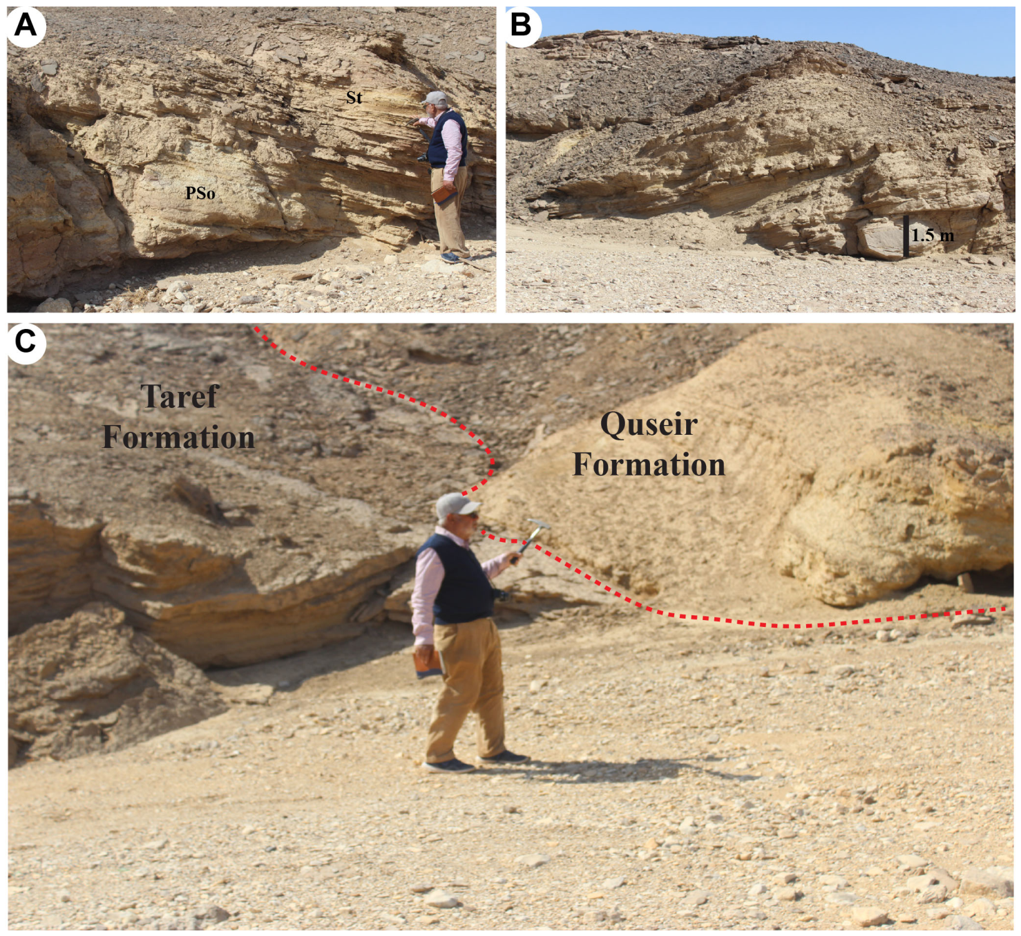
4.6. Taref Formation
5. Lithostratigraphic Correlation and Discussion
5.1. Local Framework: Change from Previous Interpretations, Strengths, and Limitations
5.2. Regional Correlation and Uncertainty
5.3. Depositional-Environment Implications
5.4. Implications for Nubian Sandstone Terminology
6. Conclusions
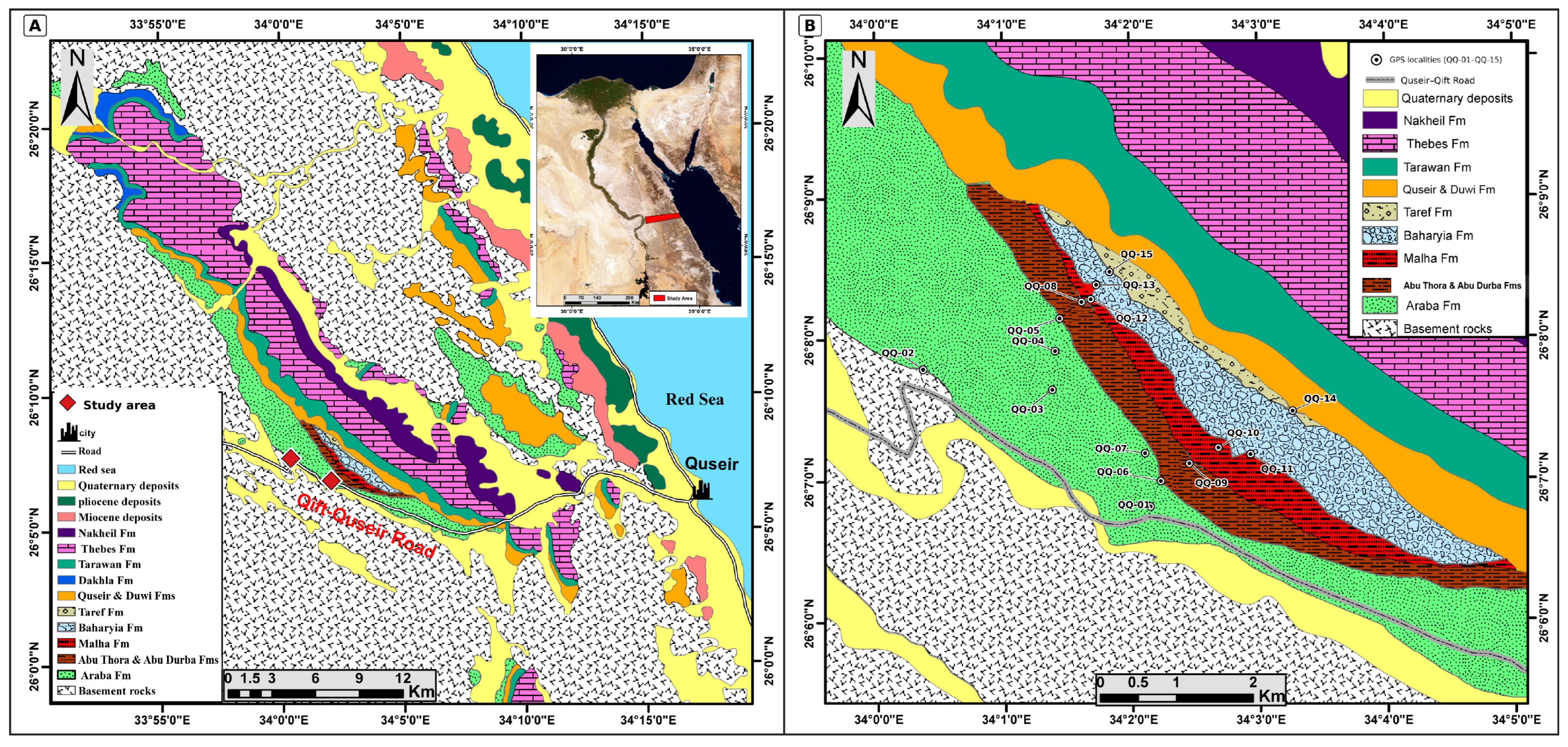
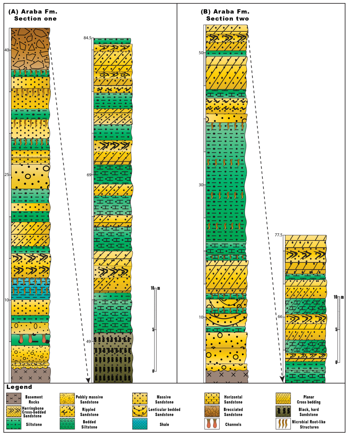
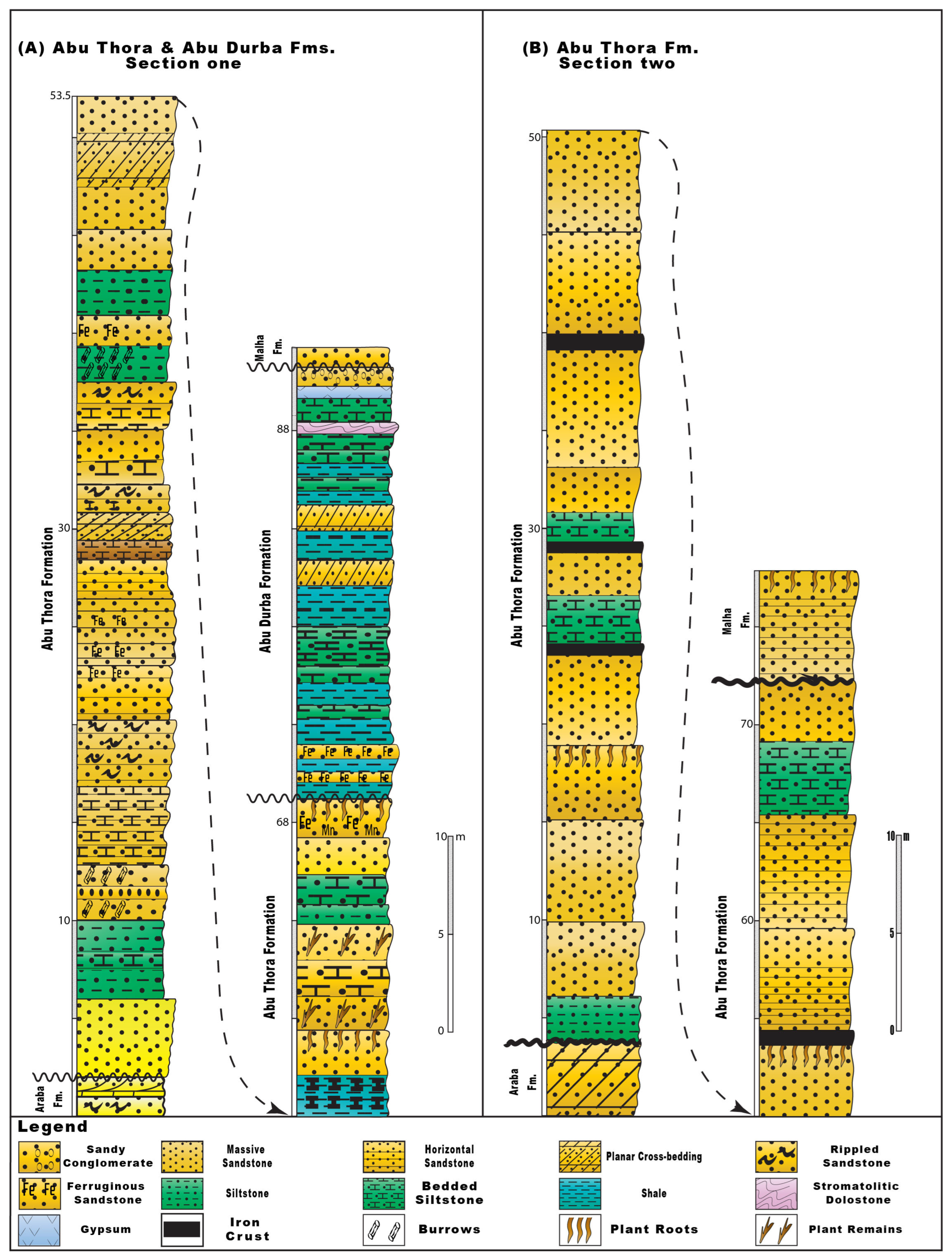
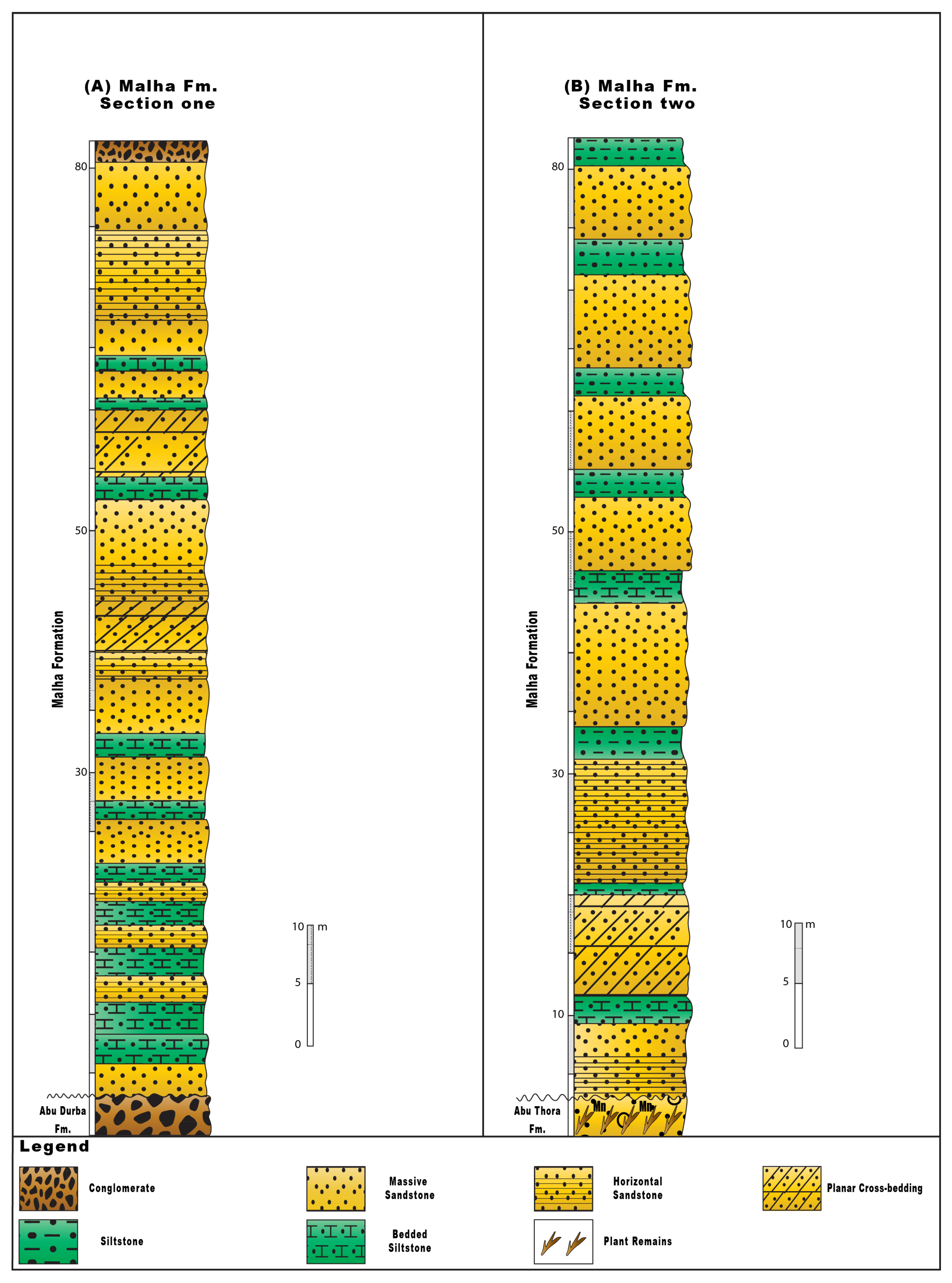
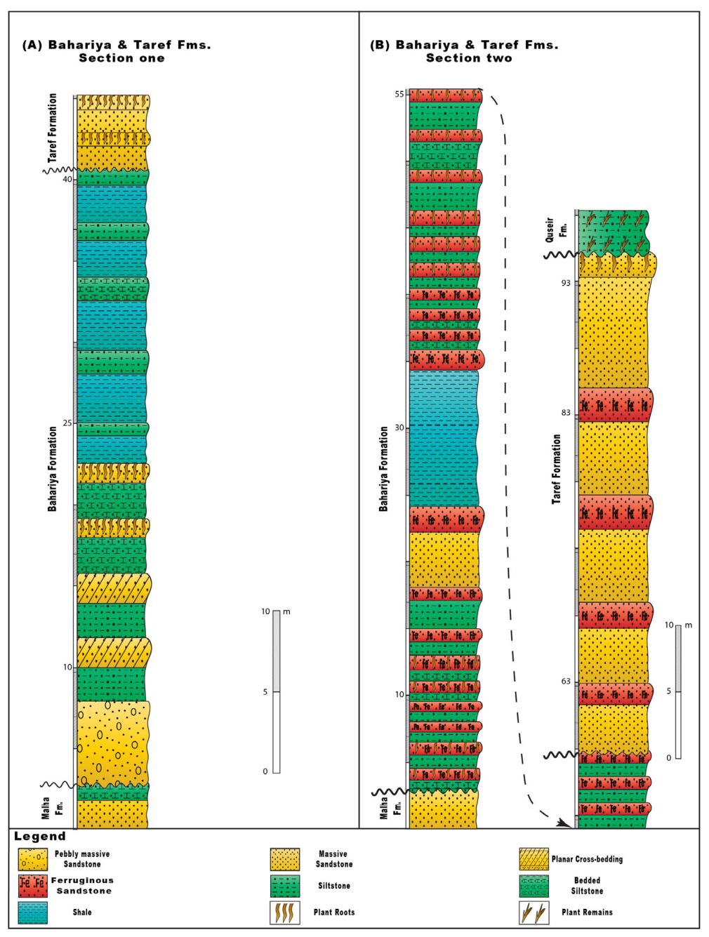
- Eight composite logs tied to 18 GPS-referenced localities distinguish six formation-scale packages along the Quseir–Qift Road: Araba (77.5–84.5 m), Abu Thora (68–72 m), the restricted Abu Durba interval (approximately 24 m), Malha (approximately 78 m), Bahariya (37–60 m), and Taref (7–37 m). The logs are anchored by principal section controls and supplemented by boundary and lateral-continuity localities rather than derived by averaging all sites.
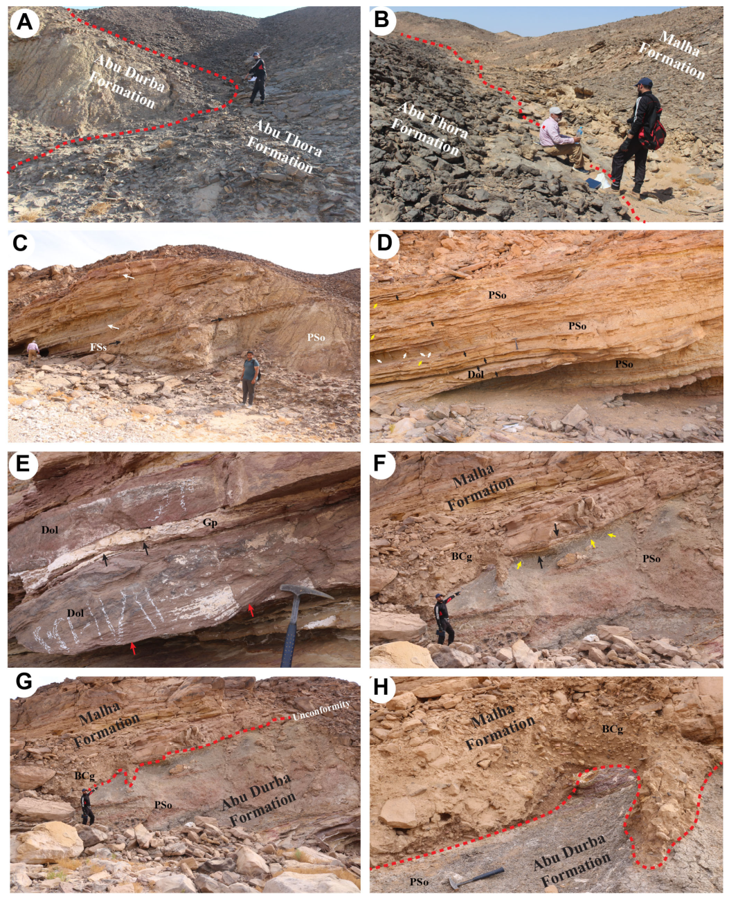
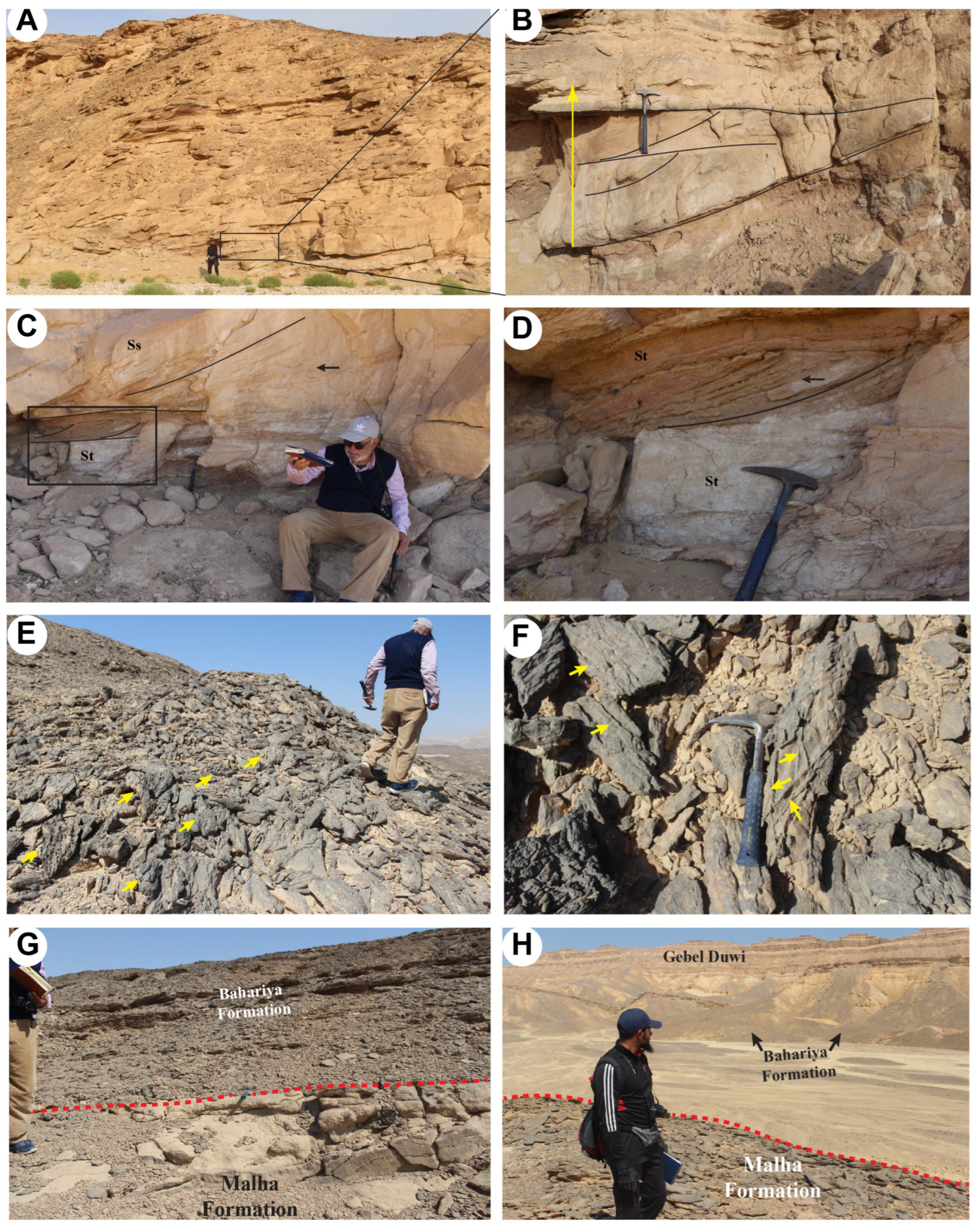
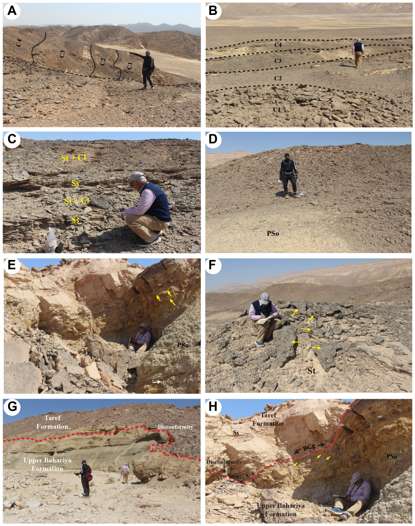
- The most diagnostic local boundaries are the basal Araba nonconformity, the sharp Araba–Abu Thora lithological transition that is apparently conformable at the illustrated contact, the restricted Abu Durba package and its erosional upper boundary, the Malha erosional base above Abu Durba or Abu Thora, the repeated Malha–Bahariya contacts, and the erosional Bahariya–Taref boundary. The local absence of Abu Durba on one traverse demonstrates that lateral preservation varies within the corridor.
- Facies associations are consistent with a mainly fluvial succession modified locally by tidal or shallow-water influence in Araba and Abu Thora, a restricted evaporitic marginal setting in Abu Durba, and fluvial to floodplain or marginal settings in the younger units. These environmental interpretations support the field description but do not define the formations or establish their ages.
- The six names provide a practical local working lithostratigraphic framework, but their ages remain regional correlation-based assignments. In the absence of independent local biostratigraphic or geochronologic control, exact time equivalence and isochrony across Egyptian basins are not demonstrated. The study therefore offers a testable local subdivision rather than a formal nomenclatural revision or a definitive regional solution for the Nubian Sandstone.
Supplementary Materials
Author Contributions
Funding
Institutional Review Board Statement
Informed Consent Statement
Data Availability Statement
Acknowledgments
Conflicts of Interest
References
- Russegger, J. Kreide und Sandstein: Einfluss von Granit auf letzteren. Neues Jahrb. Mineral. 1837, 665–669. [Google Scholar]
- Youssef, M. Stratigraphical Studies in Qusseir Area. Ph.D. Thesis, Alexandria University, Alexandria, Egypt, 1949. [Google Scholar]
- Youssef, M. Upper Cretaceous rocks in Quseir area. Bull. Inst. Égypte 1957, 7, 35–63. [Google Scholar]
- Ghorab, M. A summary of a proposed rock-stratigraphic classification for the Upper Cretaceous rocks in Egypt. J. Geol. Soc. Egypt 1956, 13, 16–39. [Google Scholar]
- Said, R. The Geology of Egypt; Elsevier: Amsterdam, The Netherlands, 1962; 377p. [Google Scholar]
- Issawi, B. Review of Upper Cretaceous–Lower Tertiary stratigraphy in central and southern Egypt. AAPG Bull. 1972, 56, 1448–1463. [Google Scholar] [CrossRef] [Scilit]
- Ward, W.; McDonald, K. Nubia Formation of central Eastern Desert, Egypt: Major subdivisions and depositional setting. AAPG Bull. 1979, 63, 975–983. [Google Scholar] [CrossRef] [Scilit]
- Abdel-Fattah, Z.A. Fluvial architecture of the Upper Cretaceous Nubia Sandstones: An ancient example of sandy braided rivers in central Eastern Desert, Egypt. Sediment. Geol. 2021, 420, 105923. [Google Scholar] [CrossRef] [Scilit]
- Kassab, W.G.; Abu El-Kheir, G.A.; AbdelGawad, M.K. First occurrence of sauropod and theropod footprints in the pre-Campanian deposits of the Nubian Sandstone, south Eastern Desert, Egypt. Geol. J. 2022, 57, 1572–1583. [Google Scholar] [CrossRef] [Scilit]
- Issawi, B.; Francis, M.H.; Youssef, E.A.A.; Osman, R.A. The Phanerozoic Geology of Egypt: A Geodynamic Approach, 2nd ed.; Special Publication No. 81; Egyptian Mineral Resources Authority: Cairo, Egypt, 2009; 589p.
- Barthel, K.W.; Boettcher, R. Abu Ballas Formation: A significant lithostratigraphic unit of the former ‘Nubian Series’. Mitt. Bayer. Staatssamml. Paläontol. Hist. Geol. 1978, 18, 155–166. [Google Scholar]
- Klitzsch, E. Geologische Bearbeitung Südwest-Ägyptens: Programm und erste Ergebnisse. Geol. Rundsch. 1978, 67, 509–520. [Google Scholar]
- Klitzsch, E. Zur Geologie des Gilf-Kebir-Gebietes in der Ostsahara. Clausthal. Geol. Abh. 1979, 30, 113–132. [Google Scholar]
- Klitzsch, E. Plate tectonics and cratonal geology in northeast Africa, Egypt/Sudan. Geol. Rundsch. 1986, 75, 755–768. [Google Scholar] [CrossRef] [Scilit]
- Klitzsch, E.; Harms, J.C.; Lejal-Nicol, A.; List, F.K. Major subdivisions and depositional environments of Nubia strata, southwestern Egypt. AAPG Bull. 1979, 63, 967–974. [Google Scholar] [CrossRef] [Scilit]
- Barthel, K.W.; Herrmann-Degen, W.; Falkner, G. Late Cretaceous and Early Tertiary stratigraphy in the Great Sand Sea and its southeastern margins, Farafra and Dakhla oases, southwestern Desert, Egypt. Mitt. Bayer. Staatssamml. Paläontol. Hist. Geol. 1981, 21, 141–182. [Google Scholar]
- Klitzsch, E.; Lejal-Nicol, A. Flora and fauna from strata in southern Egypt and northern Sudan, Nubia and surrounding areas. Berl. Geowiss. Abh. A 1984, 50, 47–79. [Google Scholar]
- Klitzsch, E.; Wycisk, P. Geology of sedimentary basins of northern Sudan and bordering areas. Berl. Geowiss. Abh. A 1987, 75, 97–136. [Google Scholar]
- Klitzsch, E.; Schandelmeier, H. Southwestern Desert. In The Geology of Egypt; Said, R., Ed.; Balkema: Rotterdam, The Netherlands, 1990; pp. 249–257. [Google Scholar]
- Egyptian Geological Survey and Mining Authority (EGSMA). Geologic Map of Quseir, Arab Republic of Egypt, Sheet No. 36, Scale 1:250,000; EGSMA: Cairo, Egypt, 1997. [Google Scholar]
- Stern, R.J. Arc assembly and continental collision in the Neoproterozoic African Orogen: Implications for the consolidation of Gondwanaland. Annu. Rev. Earth Planet. Sci. 1994, 22, 319–351. [Google Scholar] [CrossRef]
- Stern, R.J. Crustal evolution in the East African Orogen: A neodymium isotopic perspective. J. Afr. Earth Sci. 2002, 34, 109–117. [Google Scholar] [CrossRef] [Scilit]
- Kusky, T.M.; Matsah, M.I. Neoproterozoic dextral faulting on the Najd Fault System, Saudi Arabia, preceded sinistral faulting and escape tectonics related to closure of the Mozambique Ocean. Geol. Soc. Lond. Spec. Publ. 2003, 206, 327–361. [Google Scholar] [CrossRef] [Scilit]
- Khozyem, H.; Tantawy, A.A.; Mahmoud, A.; Emam, A.; Adatte, T. Biostratigraphy and geochemistry of the Cretaceous–Paleogene (K/Pg) and early Danian event (Dan-C2), a possible link to Deccan volcanism: New insights from the Red Sea, Egypt. J. Afr. Earth Sci. 2019, 160, 103645. [Google Scholar] [CrossRef] [Scilit]
- Hassan, A. A new Carboniferous occurrence in Abu Durba, Sinai, Egypt. In Proceedings of the 6th Arab Petroleum Congress, Baghdad, Iraq, 6–13 March 1967; Paper 39(B-3). 11p. [Google Scholar]
- Said, R. Explanatory Notes to Accompany the Geological Map of Egypt; Ministry of Industry, Petroleum and Mineral Wealth, Geological Survey of Egypt: Cairo, Egypt, 1971.
- Al-Nashar, A.M.; Abdel Hafez, N.A.A.; Abd El-Moghny, M.W.A.; Awad, A.; Farouk, S.; Ayyad, H.M. Integrating facies, mineralogy, and paleomagnetism to constrain the age and provenance of Paleozoic siliciclastic sedimentary rocks along the northern Gondwana margin: Insights from the Araba and Naqus formations in western Gulf of Suez, Egypt. Int. J. Earth Sci. 2024, 113, 923–950. [Google Scholar] [CrossRef] [Scilit]
- Kora, M. Lithostratigraphy of the Early Paleozoic succession in Ras El Naqab area, east-central Sinai, Egypt. Newsl. Stratigr. 1991, 24, 45–57. [Google Scholar] [CrossRef] [Scilit]
- Weissbrod, T. The Paleozoic of Israel and Adjacent Countries; Report MP 600/81; Geological Survey of Israel: Jerusalem, Israel, 1981.
- Kora, M. The Paleozoic Outcrops of Um Bogma Area, Sinai. Ph.D. Thesis, Mansoura University, Mansoura, Egypt, 1984. [Google Scholar]
- El-Sharkawi, M.A.; El-Aref, M.M.; Abdel-Motelib, A. Syngenetic and paleokarstic copper mineralization in the Palaeozoic platform sediments of west-central Sinai, Egypt. In Sediment-Hosted Mineral Deposits: Proceedings of a Symposium Held in Beijing, China, 30 July–4 August 1988; Blackwell Publishing: Oxford, UK, 1990; pp. 157–171. [Google Scholar]
- Abdallah, A.M. Paleozoic rocks in Egypt. Tech. Poszuk. Geol. Geosynoptyka Geoterm. 1992, 3, 1–12. [Google Scholar]
- El-Fawal, F. Abu Thora Formation, west-central Sinai: Facies analysis and depositional environment. Egypt. J. Geol. 1994, 38, 73–103. [Google Scholar]
- Kora, M. Carboniferous miospore assemblages from the Abu Rodeiyim boreholes, west-central Sinai, Egypt. Rev. Micropaléontol. 1993, 36, 235–255. [Google Scholar]
- Kora, M. Carboniferous macrofauna from Sinai, Egypt: Biostratigraphy and palaeogeography. J. Afr. Earth Sci. 1995, 20, 37–51. [Google Scholar] [CrossRef] [Scilit]
- El-Agami, N. Geology and Radioactivity Studies on the Paleozoic Rock Units in the Sinai Peninsula, Egypt. Ph.D. Thesis, Faculty of Science, Mansoura University, Mansoura, Egypt, 1996. [Google Scholar]
- Klitzsch, E. Paleogeographical development and correlation of continental strata, former Nubian Sandstone, in northeast Africa. J. Afr. Earth Sci. 1990, 10, 199–213. [Google Scholar] [CrossRef] [Scilit]
- Kora, M. Biostratigraphy of the Late Paleozoic succession in Gabal Ekma, southwestern Sinai, Egypt. Neues Jahrb. Geol. Paläontol. Monatshefte 1989, 293–307. [Google Scholar] [CrossRef] [Scilit]
- Kora, M. Carboniferous macrofauna from Wadi Khaboba, west-central Sinai, Egypt. Geol. Palaeontol. 1992, 26, 13–27. [Google Scholar]
- Abdallah, A.M.; El Adindani, A.; Fahmy, N. Stratigraphy of the Lower Mesozoic Rocks, Western Side of the Gulf of Suez, Egypt; Paper No. 27; Geological Survey and Mineral Research Department: Cairo, Egypt, 1963; 23p. [Google Scholar]
- Said, R. (Ed.) The Geology of Egypt; Balkema: Rotterdam, The Netherlands, 1990; 734p. [Google Scholar]
- Stromer, E. Die Topographie und Geologie der Strecke Gharag–Baharije nebst Ausführungen über die geologische Geschichte Ägyptens. Abh. K. Bayer. Akad. Wiss. Math.-Phys. Kl. 1914, 24, 1–78. [Google Scholar]
- El-Akkad, S.; Issawi, B. Geology and Iron Ore Deposits of the Bahariya Oasis; Paper No. 18; Geological Survey of Egypt: Cairo, Egypt, 1963; 301p. [Google Scholar]
- Khalifa, M.A.; El Hasan, M.A. Lithofacies, cyclicity, diagenesis and depositional environments of the Upper Cenomanian El Heiz Formation, Bahariya Oasis, Western Desert, Egypt. J. Afr. Earth Sci. 1993, 17, 555–570. [Google Scholar] [CrossRef] [Scilit]
- Soliman, H.E.; Khalifa, M.A. Stratigraphy, facies and depositional environments of the Lower Cenomanian Bahariya Formation, Bahariya Oasis, Western Desert, Egypt. Egypt. J. Geol. 1993, 37, 193–209. [Google Scholar]
- Moustafa, A.R.; Saoudi, A.; Moubasher, A.; Ibrahim, I.M.; Molokhia, H.; Schwartz, B. Structural setting and tectonic evolution of the Bahariya Depression, Western Desert, Egypt. GeoArabia 2003, 8, 91–124. [Google Scholar] [CrossRef] [Scilit]
- Catuneanu, O.; Khalifa, M.A.; Wanas, H. Sequence stratigraphy of the Lower Cenomanian Bahariya Formation, Bahariya Oasis, Western Desert, Egypt. Sediment. Geol. 2006, 190, 121–137. [Google Scholar] [CrossRef] [Scilit]
- Awad, G.H.; Ghobrial, M.G. Zonal Stratigraphy of Kharga Oasis; Paper No. 34; Geological Survey of Egypt: Cairo, Egypt, 1966; pp. 1–77. [Google Scholar]
- Issawi, B.; El Hinnawi, M.; Francis, M.; Mazhar, A. The Phanerozoic Geology of Egypt: A Geodynamic Approach; Special Publication No. 76; Egyptian Geological Survey: Cairo, Egypt, 1999; 462p. [Google Scholar]
- Maher, A.; Bek, J. Lowermost Carboniferous (Tournaisian) miospore assemblages from the July Field, Gulf of Suez, Egypt: Biostratigraphic and palaeoenvironmental implications. Life 2025, 15, 872. [Google Scholar] [CrossRef] [Scilit] [PubMed]



| Source | Geographic/Analytical Emphasis | Contribution Relevant to the Local Problem | Relation to the Present Framework |
|---|---|---|---|
| Youssef [2,3] | Quseir area; stratigraphic studies and Upper Cretaceous relationships | Established an early local stratigraphic framework for the Quseir area. | Provides local historical context; the present study adds GPS-referenced boundary control and a six-formation field subdivision of the Nubian Sandstone interval. |
| Said [5]; Issawi [6] | Egypt-wide and central–southern Egypt syntheses | Provided regional stratigraphic and chronostratigraphic context for Nubian Sandstone and younger Cretaceous successions. | Regional syntheses guide comparison, but local units here are differentiated from field evidence before regional age assignment. |
| Ward and McDonald [7] | Central Eastern Desert; Nubia Formation subdivisions and depositional setting | Demonstrated important internal subdivision and sedimentological organization within the Nubia Formation. | An important local precedent; the present study tests six established formation names against measured vertical successions, explicit contacts, and two-traverse boundary relationships along the Quseir–Qift corridor. |
| Abdel-Fattah [8] | Central Eastern Desert; Upper Cretaceous Nubia fluvial architecture | Documented high-resolution sedimentary architecture and fluvial organization. | Provides sedimentological context; the present contribution is a formation-scale lithostratigraphic framework for the broader exposed succession. |
| Kassab et al. [9] | Southern Eastern Desert; pre-Campanian Nubian Sandstone footprints | Added palaeontological/ichnological evidence from Nubian Sandstone strata. | Biogenic observations are used here only as supporting evidence tied to field-defined units and are not treated as independent age markers. |
| EGSMA Quseir sheet [20] | Regional geological mapping at 1:250,000 | Provides the regional geological base and distribution of major rock units. | The present 1:25,000 field framework adds 15 corridor GPS controls and formation-contact interpretation; the restricted Abu Durba interval is resolved in logs and field observations rather than as a separate map polygon at this scale. |
| Present study | Quseir–Qift corridor; 18 localities and eight composite logs | Integrates measured vertical successions, formation contacts, lateral field controls, and regional comparison. | Recognizes six established formation names locally; it proposes neither new formal units nor independent local chronostratigraphic ages. |
| Formation | Stratigraphic Position | Main Lithology | Thickness | Lower Contact | Upper Contact | Diagnostic Separation from Adjacent Units |
|---|---|---|---|---|---|---|
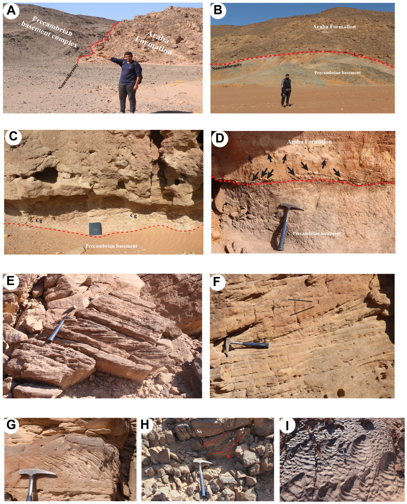
| Araba Formation | Lowermost locally recognized unit; overlies the Precambrian basement and underlies the Abu Thora Formation | Basal conglomerate, pebbly sandstone, medium- to coarse-grained sandstone, siltstone, and shale/paleosol-like horizons | 84.5 m and 77.5 m in the studied composite logs; basal conglomerate ≈ 1.5 m | Sharp erosional nonconformity above Precambrian crystalline basement | Sharp, mappable lithological transition; no erosional lag or relief observed at the illustrated contact (apparently conformable) | Basement nonconformity plus basal conglomerate/pebbly sandstone distinguish the base; upward change to finer, more heterolithic strata separates Araba from Abu Thora. |
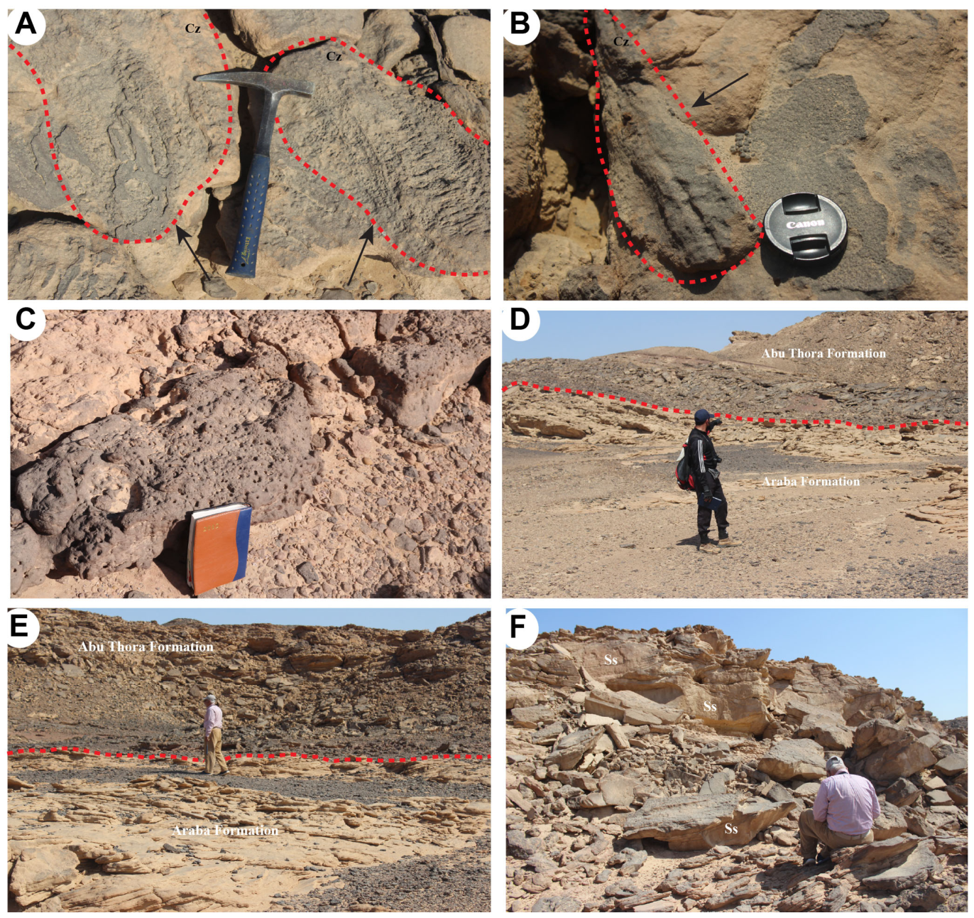
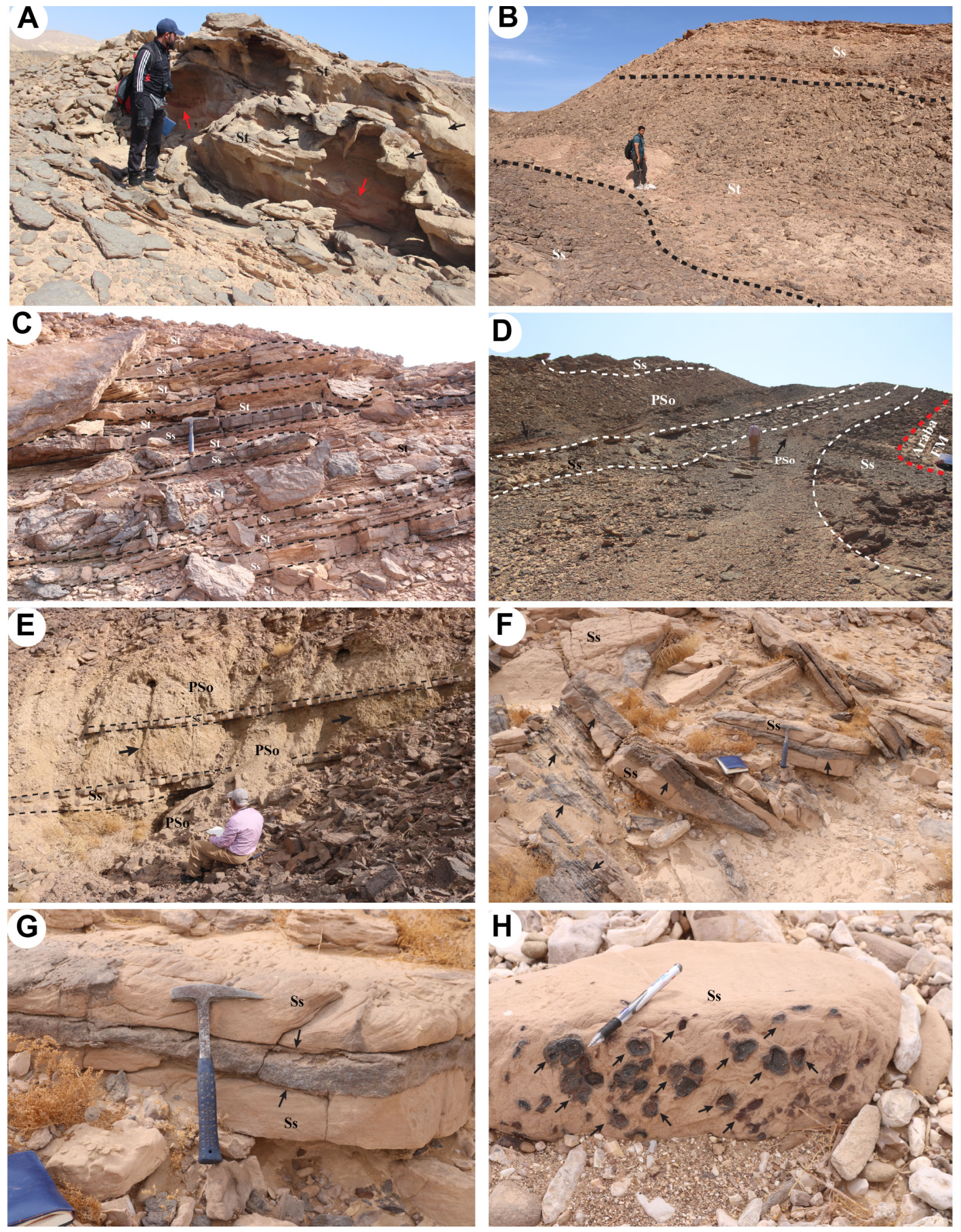
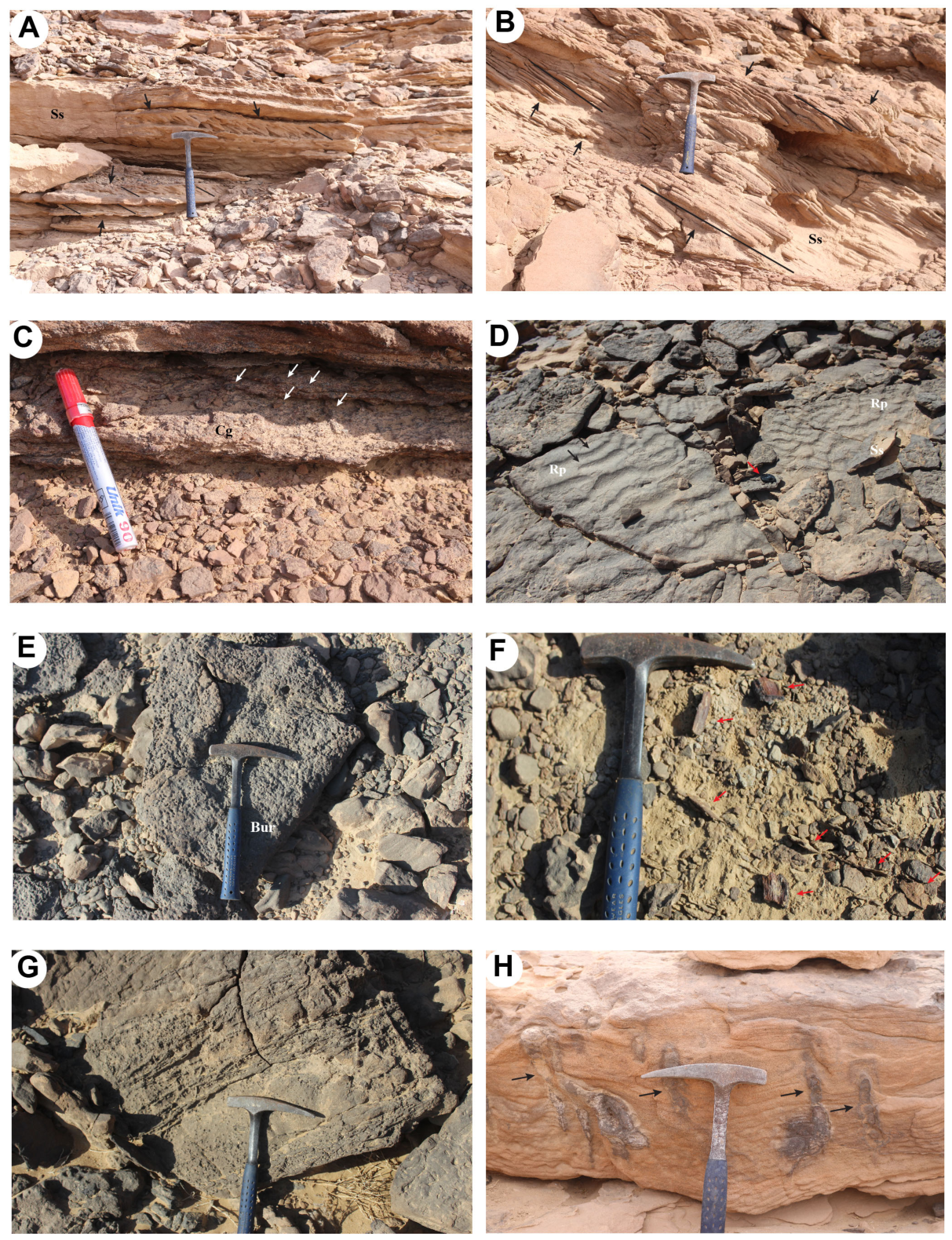
| Abu Thora Formation | Overlies the Araba Formation; underlies the Abu Durba Formation, where it is preserved; or the Malha Formation, where Abu Durba is absent | Fine- to medium-grained sandstone, siltstone, heterolithic sandstone–siltstone intervals, paleosol-bearing horizons, and ferruginous/Mn-rich intervals | 68–72 m in the studied composite logs | Sharp, mappable lithological transition above Araba; apparently conformable at the illustrated contact | Abu Durba where it is preserved; the erosional Malha base, where Abu Durba is absent | Finer heterolithic sandstone–siltstone architecture with paleosol-bearing and ferruginous/Mn-rich intervals contrasts with coarser Araba below; the absence of the dolostone–gypsum association distinguishes it from Abu Durba, and the Malha basal erosional surface separates it where Abu Durba is absent. |
| Abu Durba Formation | Locally preserved between the Abu Thora and Malha formations | Paleosol-rich claystone, ferruginous sandstone, dolostone, gypsum, and stromatolitic dolostone | Approximately 24 m in the available composite log | Sharp lithological boundary above Abu Thora | Sharp erosional unconformity below Malha | The restricted claystone–dolostone–gypsum package with stromatolitic dolostone lies between the siliciclastic Abu Thora below and the basal-conglomeratic Malha above; its local absence is itself a mapped/section relationship. |
| Malha Formation | Overlies the Abu Durba Formation, where it is preserved, or the Abu Thora Formation, where Abu Durba is absent; underlies the Bahariya Formation | Sandstone, siltstone, claystone, basal conglomeratic interval, and terminal ferruginous sandstone; informal lower and upper intervals | Approximately 78 m in the studied composite logs | Major erosional unconformity above Abu Durba, where it is preserved, or directly above Abu Thora, where Abu Durba is absent | Sharp, non-erosional lithostratigraphic contact with Bahariya | Erosional basal conglomerate and overlying sandstone–siltstone–claystone packages distinguish Malha from older units; the terminal ferruginous sandstone is followed by the finer cyclic Bahariya succession. |
| Bahariya Formation | Overlies the Malha Formation and underlies the Taref Formation | Fine- to medium-grained sandstone, siltstone, claystone, ferruginous bands/crusts, and paleosol-bearing intervals | 37 m and 60 m in the studied composite logs | Sharp, non-erosional lithostratigraphic contact above Malha | Sharp erosional contact with Taref | Cyclic fine-grained ferruginous sandstone–siltstone–claystone and paleosol-bearing intervals contrast with Malha below and are truncated by the coarser basal lag/pebbly sandstone of Taref above. |
| Taref Formation | Uppermost locally recognized Nubian Sandstone unit; overlies the Bahariya Formation and underlies the Quseir Formation | Ferruginous quartzose and pebbly sandstone with subordinate siltstone and shale; local greenish-gray siltstone upward | 7 m and 37 m in the studied composite logs | Sharp erosional contact above Bahariya | Sharp lithostratigraphic contact with the Quseir Formation | Basal erosional lag and ferruginous/pebbly sandstone distinguish Taref from finer cyclic Bahariya below; the upper boundary is marked by a shift to finer Quseir siltstone and shale. |
| Local Formation | Evidence Observed in Quseir–Qift Study Area | Correlated Established Unit/Reference Area | Reference-Area Comparison Used | Correlation Limitation/Confidence | Key Refs. |
|---|---|---|---|---|---|
| Araba Formation | Basement nonconformity; basal conglomerate and pebbly sandstone; coarse-to-finer vertical organization; Cruziana-like and Skolithos-like field morphologies. | Araba Formation; Sinai and Wadi Araba–Umm Bogma framework | Comparable basal position above crystalline basement and sandstone-dominated lower Paleozoic succession; recent Wadi Dakhl work provides independent regional age context. | Strong local package recognition; the regional name is lithostratigraphically compatible, but no independent local Cambrian age exists and field trace labels are not formal index-fossil determinations. | [25,26,27,28] |
| Abu Thora Formation | Heterolithic sandstone–siltstone succession; paleosol-bearing intervals; plant/root structures; ferruginous and Mn-rich features; position above Araba. | Abu Thora Formation; west-central Sinai | Comparable heterolithic siliciclastic architecture and stratigraphic position within established Carboniferous successions. | Local recognition is moderate to strong; exact Carboniferous age equivalence is not independently demonstrated and facies convergence remains possible. | [29,30,31,32,33,34,35,36] |
| Abu Durba Formation | Restricted claystone–dolostone–gypsum package with stromatolitic dolostone; sharp contacts; present on QQ-07/QQ-09 traverse and absent on QQ-05–QQ-08 traverse. | Abu Durba/Durba Formation; Sinai | Comparable restricted fine-grained, dolomitic/evaporitic interval and stratigraphic position above Abu Thora. | Distinctive local package but limited lateral exposure; exact age equivalence with Sinai is untested locally. | [25,26,36,37,38,39] |
| Malha Formation | Erosional basal conglomerate above Abu Durba or directly above Abu Thora; sandstone–siltstone–claystone succession; terminal ferruginous sandstone. | Malha Formation; Gulf of Suez/Wadi Malha region | Comparable basal erosional surface/conglomeratic entry and variegated siliciclastic succession. | The local boundary framework is strong; the regional formation name and Early Cretaceous age remain correlation-based rather than locally dated. | [40,41] |
| Bahariya Formation | Cyclic ferruginous sandstone–siltstone–claystone succession with paleosol-bearing intervals; positioned between Malha and Taref; repeated on two traverses. | Bahariya Formation; Bahariya Oasis | Comparable cyclic ferruginous siliciclastic architecture and paleosol-bearing intervals. | Correlation is provisional because the reference area is in a different basin and similar continental-to-marginal siliciclastic facies can recur; no local Cenomanian age is independently established. | [5,42,43,44,45,46,47] |
| Taref Formation | Upper position; erosional basal lag; ferruginous and pebbly sandstone; upward-fining interval; contact below Quseir. | Taref Formation; Kharga/Western Desert | Comparable upper Nubian Sandstone position, coarse ferruginous sandstone character, and relationship below Quseir-type finer strata. | Local package recognition is strong, but regional age and isochrony are not independently demonstrated. | [16,41,48,49] |
Disclaimer/Publisher’s Note: The statements, opinions and data contained in all publications are solely those of the individual author(s) and contributor(s) and not of MDPI and/or the editor(s). MDPI and/or the editor(s) disclaim responsibility for any injury to people or property resulting from any ideas, methods, instructions or products referred to in the content. |
© 2026 by the authors. Licensee MDPI, Basel, Switzerland. This article is an open access article distributed under the terms and conditions of the Creative Commons Attribution (CC BY) license.
Share and Cite
Khalifa, M.A.; Ghoneim, M.M.; Abu El Hassan, M.M.; El Feky, A.A.; Zaky, A.S. Formation-Scale Lithostratigraphic Subdivision of the Nubian Sandstone Succession Along the Quseir–Qift Road, Eastern Desert, Egypt. Geosciences 2026, 16, 348. https://doi.org/10.3390/geosciences16090348
Khalifa MA, Ghoneim MM, Abu El Hassan MM, El Feky AA, Zaky AS. Formation-Scale Lithostratigraphic Subdivision of the Nubian Sandstone Succession Along the Quseir–Qift Road, Eastern Desert, Egypt. Geosciences. 2026; 16(9):348. https://doi.org/10.3390/geosciences16090348
Chicago/Turabian StyleKhalifa, Mohamed A., Mohamed M. Ghoneim, Mohamed Mahmoud Abu El Hassan, Ahmed Anwar El Feky, and Amr S. Zaky. 2026. "Formation-Scale Lithostratigraphic Subdivision of the Nubian Sandstone Succession Along the Quseir–Qift Road, Eastern Desert, Egypt" Geosciences 16, no. 9: 348. https://doi.org/10.3390/geosciences16090348
APA StyleKhalifa, M. A., Ghoneim, M. M., Abu El Hassan, M. M., El Feky, A. A., & Zaky, A. S. (2026). Formation-Scale Lithostratigraphic Subdivision of the Nubian Sandstone Succession Along the Quseir–Qift Road, Eastern Desert, Egypt. Geosciences, 16(9), 348. https://doi.org/10.3390/geosciences16090348