Co- and Post-Seismic Hydrogeological Anomalies in Greece from Ancient Times to the Present: Spatiotemporal and Statistical Analysis Revealing Categories, Patterns, and Insights
Abstract
1. Introduction
2. Methodology
- Peer-reviewed journal articles that involve the evaluation and mapping of EEEs, including EQHAs;
- Papers presented in national and international conferences that focus on assessing and mapping EEEs, including EQHAs;
- Scientific books that provide catalogues and detailed information about earthquakes in Greece and the Eastern Mediterranean region covering their effects on both natural and built environments, with EQHAs included among the observed impact;
- Doctoral theses examining earthquakes and their effects on the natural and built environment, including EQHAs;
- Official reports derived from field investigations and reconnaissance surveys documenting earthquake impact and associated EQHAs on the affected areas.
3. Regional Setting
3.1. Morphology of Greece
3.2. Geodynamic and Seismotectonic Setting of Greece
3.3. Hydrology of Greece—Water Districts, River Basins, Rivers and Water Bodies
3.4. Hydrogeological Regime of Greece
4. Co- and Post-Seismic Hydrogeological Anomalies in Greece
4.1. EQHAs and Causative Earthquakes
4.1.1. Minimum and Maximum Magnitudes and Intensities of Causative Earthquakes
4.1.2. Minimum and Maximum Magnitudes and Intensities for EQHAs
4.2. Functional Categories and Types of EQHAs
4.3. Temporal Distribution of EQHAs
4.4. Duration of EQHAs
4.5. Spatial Identification of the EQHAs and Location Reliability
4.6. Origin Time of the Spatially Identified EQHAs
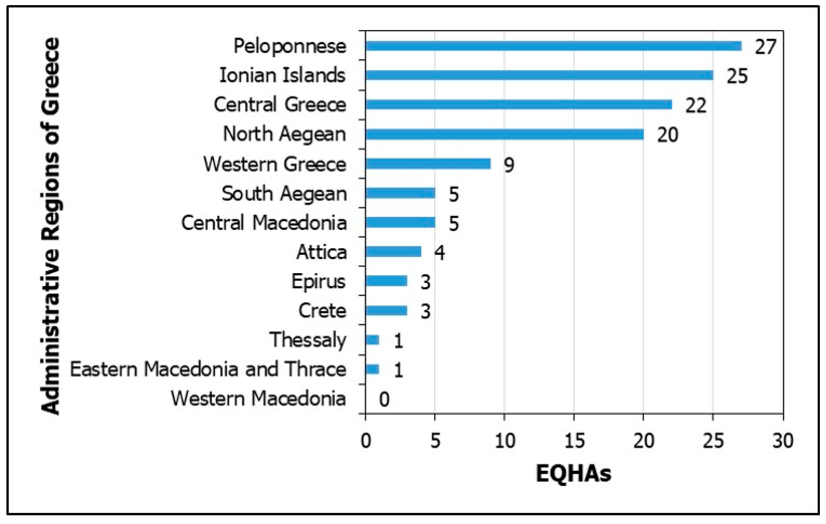
4.7. EQHAs in the Regions of Greece
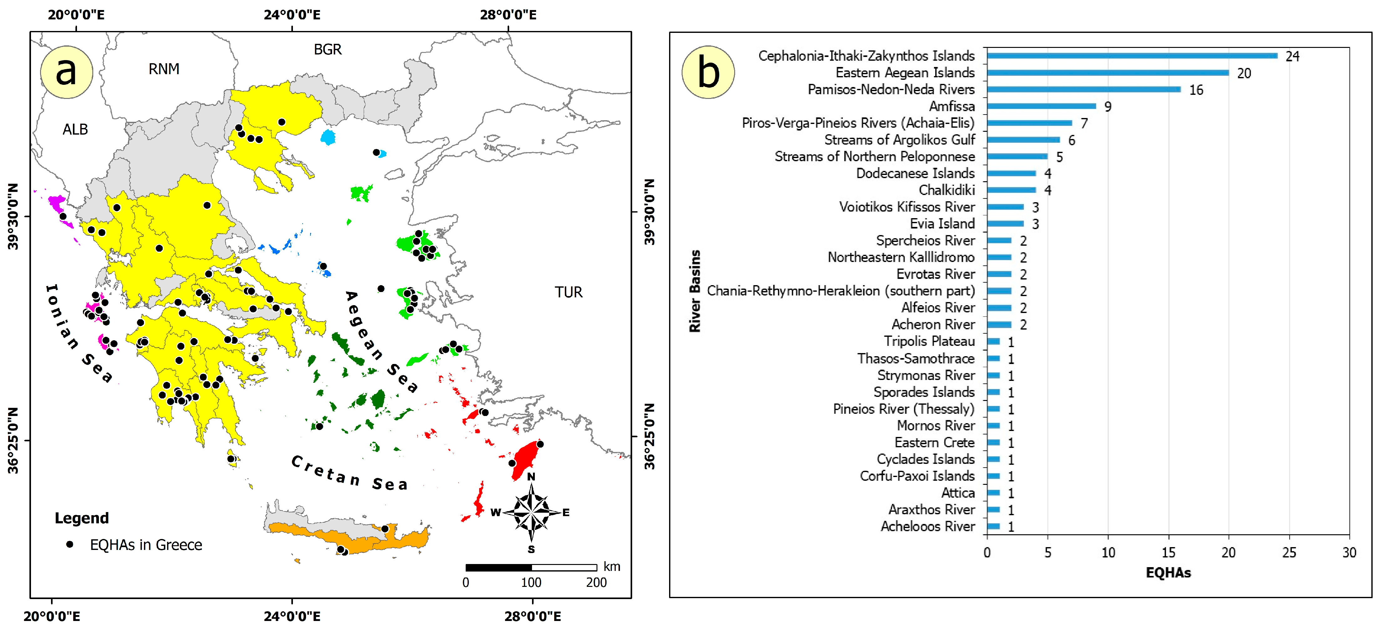
4.8. EQHAs in Water Districts and River Basins
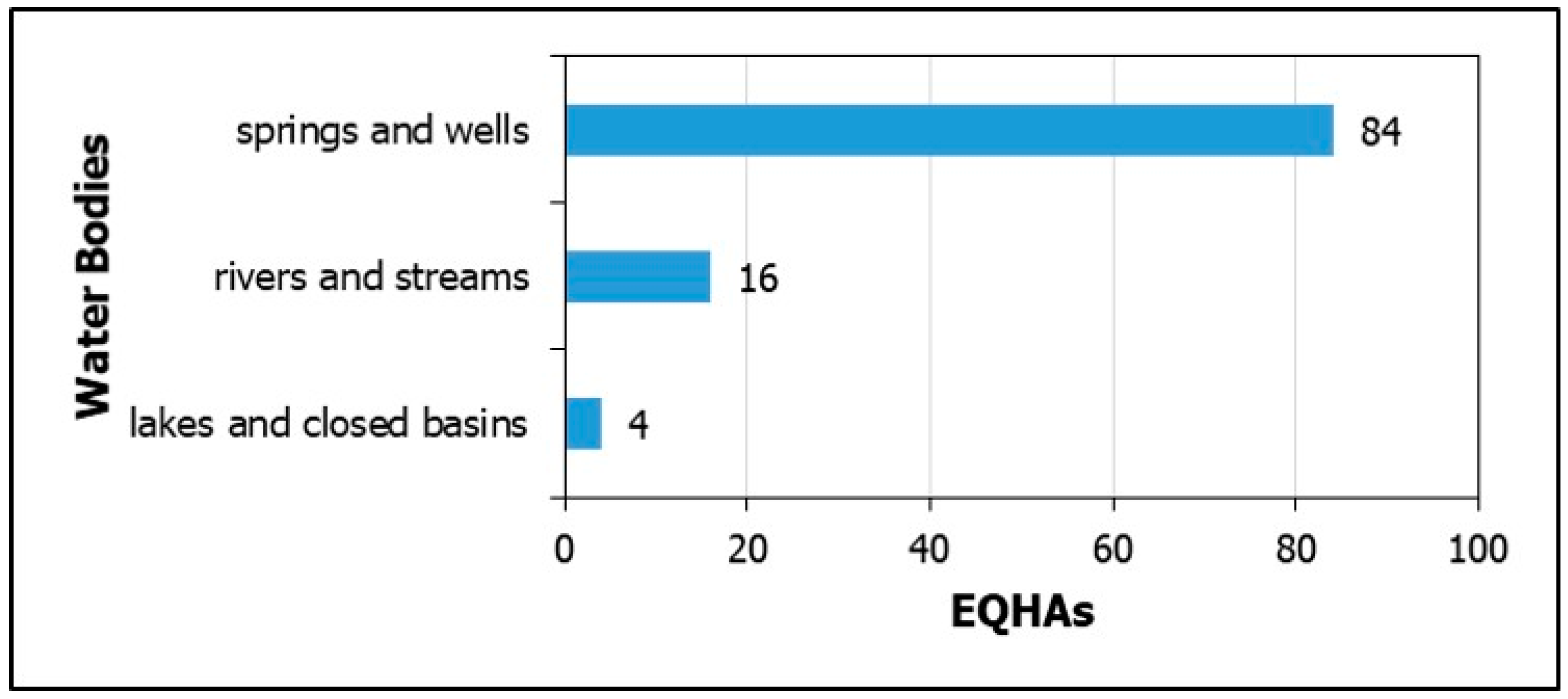
4.9. EQHAs in Water Bodies
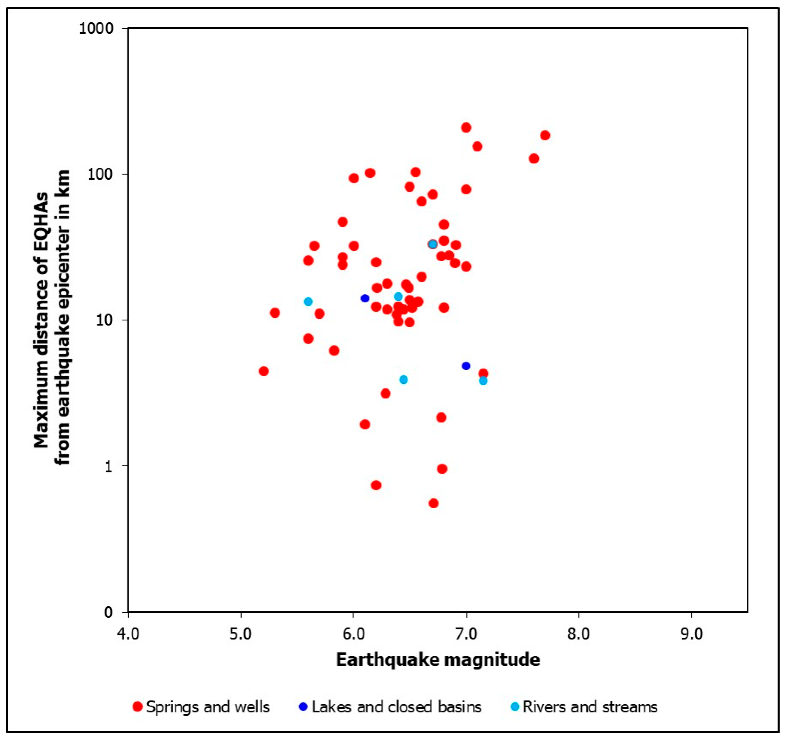
- A total of 104 water bodies were affected by EQHAs.
- A total of 84 (80.77%) of these were springs and wells. This indicates that aquifers are particularly sensitive to seismic disturbances, as temporary or permanent changes in pressure and hydraulic balance following earthquakes are more directly reflected in water intakes (springs, wells, and boreholes).
- Overall, 16 (15.38%) were branches of the drainage system (rivers and streams).
- Four (3.85%) were lakes and closed basins. This suggests a reduced direct interaction with the groundwater system, as well as a more stable hydraulic response of lakes to seismic shaking, unless accompanied by surface leakage or sink-related anomalies.
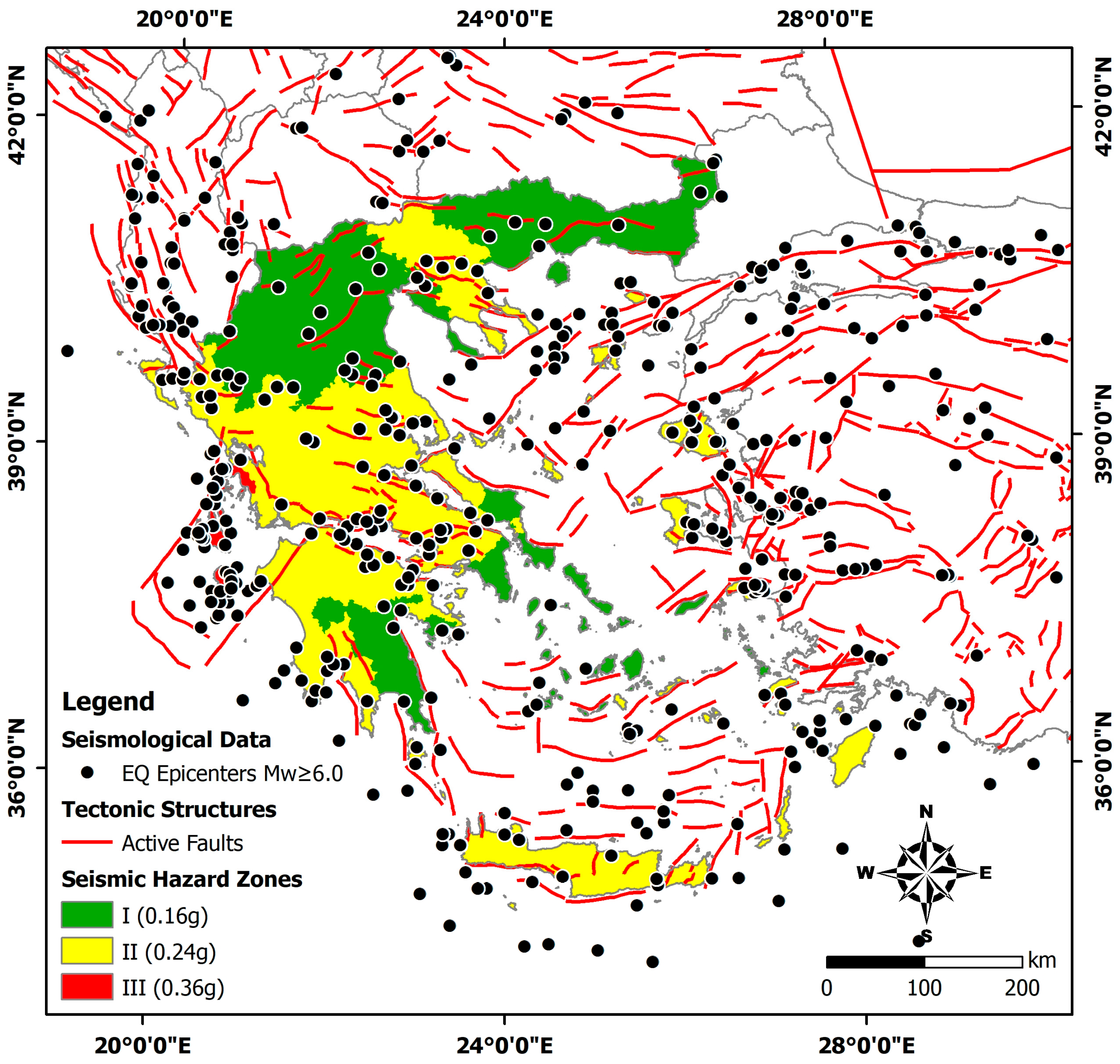
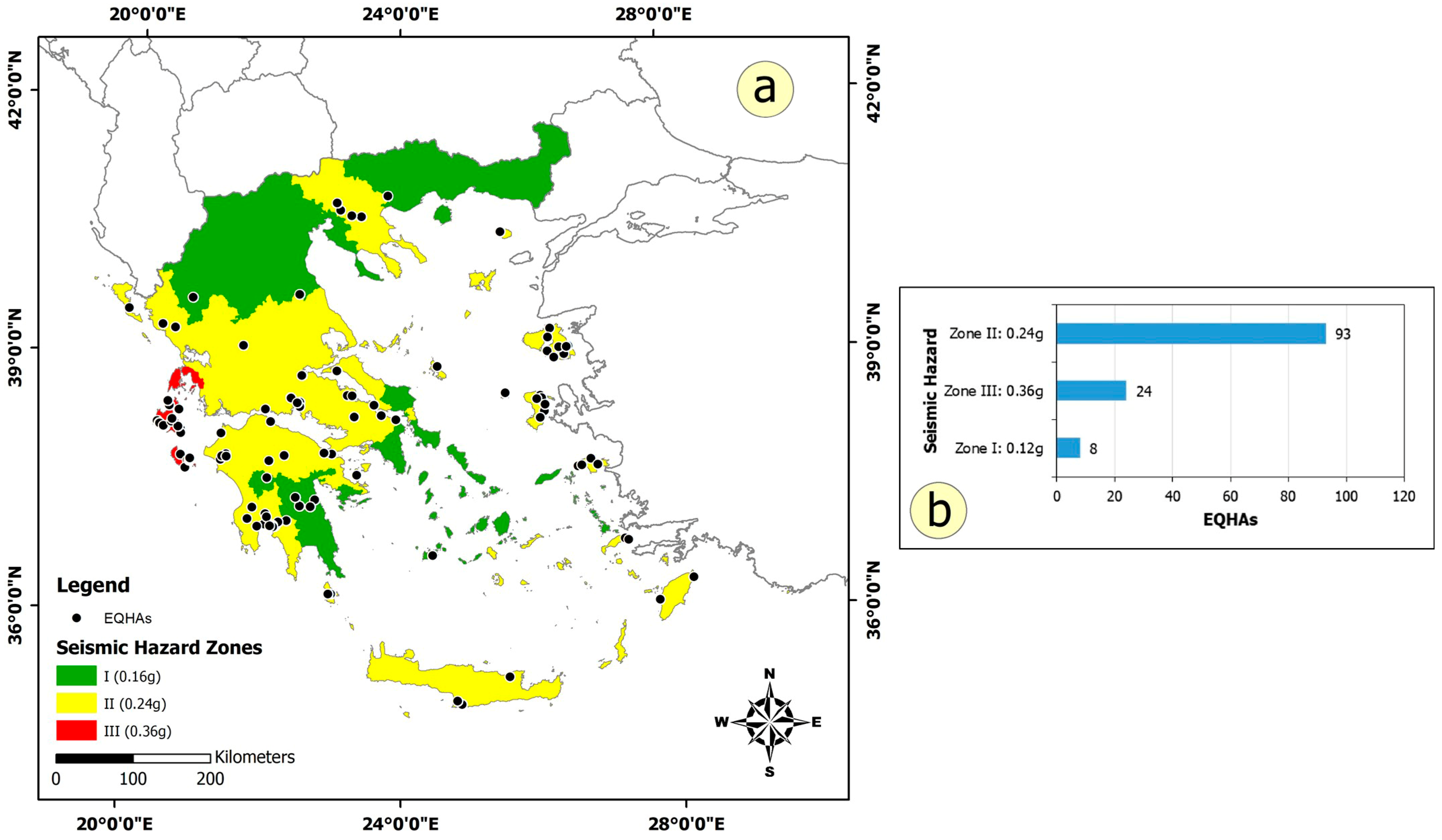
4.10. EQHAs in Seismic Hazard Zones
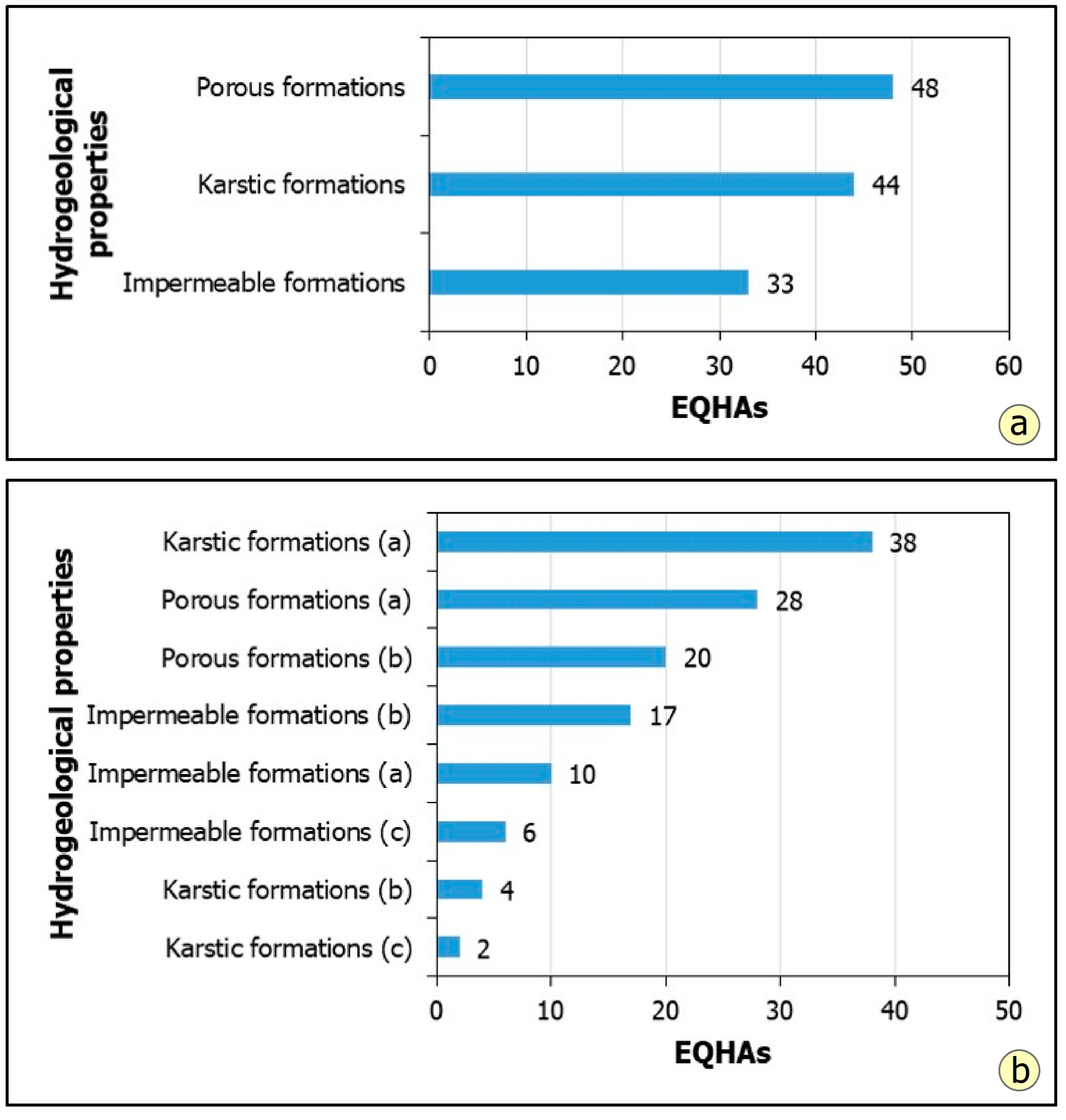
4.11. EQHAs and Hydrolithological Properties of Affected Formations
- Karstic limestones and marbles with a large extent and moderate to high permeability host the majority of geographically identified EQHAs (38, 30.4%). This indicates that karstic formations are particularly susceptible to EQHAs, likely due to their complex flow networks and their sensitivity to seismic shaking and hydraulic disturbances.
- The porous formations, particularly the granular alluvial deposits with variable permeability, as well as the non-alluvial deposits with low to very low permeability, account for 28 (%) and 20 (%) EQHAs, respectively.
- This approach reveals that even impermeable formations can exhibit EQHAs. Specifically, marble and flysch or flysch-type deposits have shown 17 (13.6%) and 10 (8%) EQHAs, respectively, with plutonic and volcanic rocks following with 6 (4.8%) EQHAs. This phenomenon is attributed to the following factors:
- ○
- In the flysch formation, sandstones and conglomerates locally predominate, resulting in the formation exhibiting low to moderate permeability and the development of small-scale aquifers.
- ○
- In metamorphic rocks, particularly within the upper part of the impermeable formations, limestones and marbles are locally interbedded, where karst aquifers often develop.
- ○
- In plutonic and volcanic rocks, zones of intense fracturing develop locally, resulting in permeability ranging from low to moderate, and allowing the formation of local aquifers that can be affected during strong seismic events, leading to the generation of hydrogeological anomalies.
4.12. Maximum Epicentral Distances of EQHAs
4.13. Impact of EQHAs on the Built and Natural Environment and the Local Population
5. Discussion
6. Conclusions
Author Contributions
Funding
Data Availability Statement
Acknowledgments
Conflicts of Interest
References
- Michetti, A.M.; Esposito, E.; Guerrieri, L.; Porfido, S.; Serva, L.; Tatevossian, R.; Vittori, E.; Audemard, F.; Azuma, T.; Clague, J.; et al. Environmental Seismic Intensity Scale 2007—ESI. Mem. Descr. Carta Geol. Ital. 2007, 74, 7–54. [Google Scholar]
- Wang, C.-Y.; Manga, M. Earthquakes and Water. In Encyclopedia of Complexity and Systems Science; Meyers, R., Ed.; Springer: New York, NY, USA, 2014. [Google Scholar] [CrossRef]
- Koizumi, N.; Minote, S.; Tanaka, T.; Mori, A.; Ajiki, T.; Sato, T.; Takahashi, H.A.; Matsumoto, N. Hydrological changes after the 2016 Kumamoto earthquake, Japan. Earth Planets Space 2019, 71, 128. [Google Scholar] [CrossRef]
- Charmoille, A.; Fabbri, O.; Mudry, J.; Guglielmi, Y.; Bertand, C. Post-seismic permeability change in a shallow fractured aquifer following a M-L 5.1 earthquake (Fourbanne karst aquifer, Jura outermost thrust unit, eastern France). Geophys. Res. Lett. 2005, 32, L18406. [Google Scholar] [CrossRef]
- Sanz de Ojeda, A.; Alhama, I.; Sanz, E. Aquifer sensitivity to earthquakes: The 1755 Lisbon earthquake. J. Geophys. Res. Solid Earth 2019, 124, 8844–8866. [Google Scholar] [CrossRef]
- Sato, T.; Kazahaya, K.; Matsumoto, N.; Takahashi, M. Deep groundwater discharge after the 2011 Mw 6.6 Iwaki earthquake, Japan. Earth Planets Space 2020, 72, 54. [Google Scholar] [CrossRef]
- Gori, F.; Barberio, M.D. Hydrogeochemical changes before and during the 2019 Benevento seismic swarm in central–southern Italy. J. Hydrol. 2022, 604, 127250. [Google Scholar] [CrossRef]
- Chen, Y.; Liu, J. Groundwater trace element changes were probably induced by the ML 3.3 earthquake in Chaoyang district, Beijing. Front. Earth Sci. 2023, 11, 1260559. [Google Scholar] [CrossRef]
- Akita, F.; Matsumoto, N. Hydrological responses induced by the Tokachi-oki earthquake in 2003 at hot spring wells in Hokkaido, Japan. Geophys. Res. Lett. 2004, 31, L16603. [Google Scholar] [CrossRef]
- Yaltirak, C.; Yalçin, T.; Bozkurtoğlu, E.; Yüce, G. Water-level changes in shallow wells before and after the 1999 İzmit and Düzce earthquakes and comparison with long-term water-level observations (1999–2004), NW Turkey. Turk. J. Earth Sci. 2005, 14, 281–309. [Google Scholar]
- Malakootian, M.; Nouri, J. Chemical Variations of Ground Water Affected by the Earthquake in Bam Region. Int. J. Environ. Res. 2010, 4, 443–454. [Google Scholar]
- Shi, Z.; Wang, G.; Liu, C. Co-seismic groundwater level changes induced by the May 12, 2008 Wenchuan earthquake in the near field. Pure Appl. Geophys. 2013, 170, 1773–1783. [Google Scholar] [CrossRef]
- Sun, X.; Wang, G.; Yang, X. Coseismic response of water level in Changping well, China, to the Mw 9.0 Tohoku earthquake. J. Hydrol. 2015, 531, 1028–1039. [Google Scholar] [CrossRef]
- Shibata, T.; Takahashi, R.; Takahashi, H.; Kagoshima, T.; Takahata, N.; Sano, Y.; Pinti, D.L. Coseismic changes in groundwater level during the 2018 Hokkaido Eastern Iburi earthquake. Earth Planets Space 2020, 72, 23. [Google Scholar] [CrossRef]
- Huang, X.; Zhang, Y. Various far-field hydrological responses during 2015 Gorkha earthquake at two distant wells. Earth Planets Space 2021, 73, 119. [Google Scholar] [CrossRef]
- Lan, S.-S.; Gu, H.-B.; Liu, Y. Changes in groundwater level and tidal response caused by the Wenchuan earthquake, China. Hydrogeol. J. 2021, 29, 1329–1341. [Google Scholar] [CrossRef]
- Uzelli, T.; Bilgiç, E.; Öztürk, B.; Baba, A.; Sözbilir, H.; Tatar, O. Effects of seismic activity on groundwater level and geothermal systems in İzmir, Western Anatolia, Turkey: The case study from October 30, 2020 Samos Earthquake. Turk. J. Earth Sci. 2021, 30, 758–778. [Google Scholar] [CrossRef]
- Cox, S.C.; Rutter, H.K.; Sims, A.; Manga, M.; Weir, J.J.; Ezzy, T.; White, P.A.; Horton, T.W.; Scott, D. Hydrological effects of the Mw 7.1 Darfield (Canterbury) earthquake, 4 September 2010, New Zealand. N. Z. J. Geol. Geophys. 2012, 55, 231–247. [Google Scholar] [CrossRef]
- Roeloffs, E.; Sneed, M.; Galloway, D.L.; Sorey, M.L.; Farrar, C.D.; Howle, J.F.; Hughes, J. Water-level changes induced by local and distant earthquakes at Long Valley caldera, California. J. Volcanol. Geotherm. Res. 2003, 127, 269–303. [Google Scholar] [CrossRef]
- Lin, Y.-Y.; Wang, S.-J.; Lai, W.-C. The research of Meinong earthquake induced hydrological anomalies and increased vertical permeability in southwestern Taiwan. In Proceedings of the EGU General Assembly 2020, Online, 4–8 May 2020. [Google Scholar] [CrossRef]
- Mavroulis, S.; Triantafyllou, I.; Karavias, A.; Gogou, M.; Katsetsiadou, K.-N.; Lekkas, E.; Papadopoulos, G.A.; Parcharidis, I. Primary and secondary environmental effects triggered by the 30 October 2020, Mw = 7.0, Samos (Eastern Aegean Sea, Greece) earthquake based on post-event field surveys and InSAR analysis. Appl. Sci. 2021, 11, 3281. [Google Scholar] [CrossRef]
- Muir-Wood, R.; King, G.C.P. Hydrological signatures of earthquake strain. J. Geophys. Res. Solid Earth 1993, 98, 22035–22068. [Google Scholar] [CrossRef]
- Ma, Y.; Wang, G.; Sun, Z.; Yu, R.; Yu, H. Groundwater level and temperature changes following the great Tangshan earthquake of 1976 near the epicenter. Geomat. Nat. Hazards Risk 2023, 14, 2197103. [Google Scholar] [CrossRef]
- Yang, P.; Sun, X.; Liu, D.; He, Z.; Li, Y. Hydrochemical Characteristics of Groundwater at the Epicenter of the 2021 Biru M6.1 Earthquake in Central Tibet. Water 2021, 13, 3111. [Google Scholar] [CrossRef]
- Kim, J.; Joun, W.-T.; Lee, S.; Kaown, D.; Lee, K.-K. Hydrogeochemical evidence of earthquake-induced anomalies in response to the 2017 MW 5.5 Pohang earthquake in Korea. Geochem. Geophys. Geosyst. 2020, 21, e2020GC009532. [Google Scholar] [CrossRef]
- Wakita, H. Water wells as possible indicators of tectonic strain. Science 1975, 189, 553–555. [Google Scholar] [CrossRef]
- Rojstaczer, S.; Wolf, S.; Michel, R. Permeability enhancement in the shallow crust as a cause of earthquake-induced hydrological changes. Nature 1995, 373, 237–239. [Google Scholar] [CrossRef]
- Wang, C.-Y.; Wang, C.-H.; Manga, M. Coseismic release of water from mountains: Evidence from the 1999 (Mw 7.5) Chi-Chi earthquake. Geology 2004, 32, 769–772. [Google Scholar] [CrossRef]
- Elkhoury, J.E.; Brodsky, E.E.; Agnew, D.C. Seismic waves increase permeability. Nature 2006, 411, 1135–1138. [Google Scholar] [CrossRef] [PubMed]
- Kinoshita, C.; Kano, Y.; Ito, H. Shallow crustal permeability enhancement in central Japan due to the 2011 Tohoku earthquake. Geophys. Res. Lett. 2015, 42, 773–780. [Google Scholar] [CrossRef]
- Sibson, R.H.; Rowland, J.V. Stress, fluid pressure and structural permeability in seismogenic crust, North Island, New Zealand. Geophys. J. Int. 2003, 154, 584–594. [Google Scholar] [CrossRef]
- Matsumoto, N.; Roeloffs, E.A. Hydrological response to earthquakes in the Haibara well, central Japan—II. Possible mechanism inferred from time-varying hydraulic properties. Geophys. J. Int. 2003, 155, 899–913. [Google Scholar] [CrossRef]
- Waller, R.M. Effects of the March 1964 Alaska Earthquake on the Hydrology of the Anchorage Area, Alaska; Professional Paper 544-B; U.S. Geological Survey; U.S. Government Printing Office: Washington, DC, USA, 1966. [Google Scholar] [CrossRef]
- Rojstaczer, S.; Wolf, S. Permeability changes associated with large earthquakes: An example from Loma Prieta, California. Geology 1992, 20, 211–214. [Google Scholar] [CrossRef]
- Koizumi, N.; Kano, Y.; Kitagawa, Y.; Sato, T.; Takahashi, M.; Nishimura, S.; Nishida, R. Groundwater anomalies associated with the 1995 Hyogo-ken Nanbu earthquake. J. Phys. Earth 1996, 44, 373–380. [Google Scholar] [CrossRef]
- Esposito, E.; Pece, R.; Porfido, S.; Tranfaglia, G. Hydrological anomalies connected to earthquakes in southern Apennines (Italy). Nat. Hazards Earth Syst. Sci. 2001, 1, 137–144. [Google Scholar] [CrossRef]
- Esposito, E.; Pece, R.; Porfido, S.; Tranfaglia, G. Ground Effects and Hydrological Changes in the Southern Apennines (Italy) in Response to the 23 July 1930 Earthquake (MS = 6.7). Nat. Hazards Earth Syst. Sci. 2009, 9, 539–550. [Google Scholar] [CrossRef]
- Zhou, B.; Liu, Q.; Chen, S.; Yang, Z. Well water temperature responses to earthquakes: Single- and double-aquifer models. Geophys. J. Int. 2025, 241, 1698–1711. [Google Scholar] [CrossRef]
- Koumantakis, I.; Mimidis, T.; Stavropoulou, X. Hydrogeological investigation within the framework of the microzoning study of Kalamata. Bull. Geol. Soc. Greece 1989, 23, 297–318. [Google Scholar]
- Fountoulis, I.G.; Mavroulis, S.D. Application of the Environmental Seismic Intensity scale (ESI 2007) and the European Macroseismic Scale (EMS-98) to the Kalamata (SW Peloponnese, Greece) earthquake (Ms = 6.2, September 13, 1986) and correlation with neotectonic structures and active faults. Ann. Geophys. 2013, 56, S0675. [Google Scholar] [CrossRef]
- Tsermegas, I. The Effects of Earthquakes on the Natural Environment in Greece. Misc. Geogr. 1998, 8, 67–76. [Google Scholar] [CrossRef]
- Mavroulis, S.; Sarantopoulou, A.; Lekkas, E. Earthquake-Triggered Landslides in Greece from Antiquity to the Present: Temporal, Spatial and Statistical GIS-Based Analysis. Land 2025, 14, 307. [Google Scholar] [CrossRef]
- Papastamatiou, D.; Mouyaris, N. The earthquake of April 30, 1954, in Sophades (Central Greece). Geophys. J. Int. 1986, 87, 885–895. [Google Scholar] [CrossRef]
- Ambraseys, N.N.; Jackson, J. Seismicity and associated strain of central Greece between 1890 and 1988. Geophys. J. Int. 1990, 101, 663–708. [Google Scholar] [CrossRef]
- Lekkas, E.; Kolyva, M.; Antonopoulos, G.; Kopanas, I. The earthquakes of Zakynthos. An interpretation of the descriptions of earthquakes and correlation with the existing geological structure. Ann. Geol. Pays Hell. 1997, 1, 1033–1073. [Google Scholar]
- Ambraseys, N.N.; Jackson, J.A. Seismicity and Strain in the Gulf of Corinth (Greece) since 1694. J. Earthq. Eng. 1997, 1, 433–474. [Google Scholar] [CrossRef]
- Mavroulis, S.D.; Fountoulis, I.G.; Skourtsos, E.N.; Lekkas, E.L.; Papanikolaou, I.D. Seismic intensity assignments for the 2008 Andravida (NW Peloponnese, Greece) strike-slip event (June 8, Mw = 6.4) based on the application of the Environmental Seismic Intensity scale (ESI 2007) and the European Macroseismic scale (EMS-98). Geological structure, active tectonics, earthquake environmental effects and damage pattern. Ann. Geophys. 2013, 56, S0681. [Google Scholar] [CrossRef]
- Lekkas, E.L.; Mavroulis, S.D. Earthquake environmental effects and ESI 2007 seismic intensities of the early 2014 Cephalonia (Ionian Sea, Western Greece) earthquakes (January 26 and February 3, Mw 6.0). Nat. Hazards 2015, 78, 1517–1544. [Google Scholar] [CrossRef]
- Lekkas, E.L.; Mavroulis, S.D. Fault zones ruptured during the early 2014 Cephalonia Island (Ionian Sea, Western Greece) earthquakes (January 26 and February 3, Mw 6.0) based on the associated co-seismic surface ruptures. J. Seismol. 2016, 20, 63–78. [Google Scholar] [CrossRef]
- Mavroulis, S.; Stanota, E.-S.; Lekkas, E. Evaluation of environmental seismic intensities of all known historical and recent earthquakes felt in Zakynthos Island, Greece using the Environmental Seismic Intensity (ESI 2007) scale. Quat. Int. 2019, 532, 1–22. [Google Scholar] [CrossRef]
- Triantafyllou, I.; Papadopoulos, G.A.; Lekkas, E. Impact on built and natural environment of the strong earthquakes of 23 April 1933, and 20 July 2017, in the southeast Aegean Sea, eastern Mediterranean. Nat. Hazards 2020, 100, 671–695. [Google Scholar] [CrossRef]
- Mavroulis, S.; Lekkas, E. Revisiting the Most Destructive Earthquake Sequence in the Recent History of Greece: Environmental Effects Induced by the 9, 11 and 12 August 1953 Ionian Sea Earthquakes. Appl. Sci. 2021, 11, 8429. [Google Scholar] [CrossRef]
- Mavroulis, S.; Mavrouli, M.; Lekkas, E. Geological and hydrometeorological hazards and related disasters amid COVID-19 pandemic in Greece: Post-disaster trends and factors affecting the COVID-19 evolution in affected areas. Saf. Sci. 2021, 138, 105236. [Google Scholar] [CrossRef] [PubMed]
- Triantafyllou, I.; Koukouvelas, I.; Papadopoulos, G.A.; Lekkas, E. A Reappraisal of the Destructive Earthquake (Mw 5.9) of 15 July 1909 in Western Greece. Geosciences 2022, 12, 374. [Google Scholar] [CrossRef]
- Mavroulis, S.; Mavrouli, M.; Lekkas, E.; Carydis, P. Reconstructing Impact of the 1867 Ionian Sea (Western Greece) Earthquake by Focusing on New Contemporary and Modern Sources for Building Damage, Environmental and Health Effects. Geosciences 2024, 14, 214. [Google Scholar] [CrossRef]
- Papanikolaou, D.; Lekkas, E.; Syskakis, D.; Adamopoulou, E. Correlation on neotectonic structures with the geodynamic activity in Milos during the earthquakes of March 1992. Bull. Geol. Soc. Greece 1993, 28, 413–428. [Google Scholar]
- Pavlides, S.; Valkaniotis, S.; Papathanassiou, G.; Sboras, S.; Chatzipetros, A. Surface effects of the strong June 8, 2008, NW Peloponnese earthquake. In Proceedings of the 3rd National Conference on Earthquake Engineering and Engineering Seismology, Athens, Greece, 5–7 November 2008. (In Greek with English abstract). [Google Scholar]
- Mavroulis, S.; Lekkas, E. Evaluation of seismic intensities of historical earthquakes in the southern and southwestern Peloponnese (Greece) based on the Environmental Seismic Intensity (ESI 2007) scale. In Proceedings of the 9th International INQUA Meeting on Paleoseismology, Active Tectonics and Archeoseismology (PATA), Possidi, Greece, 25–27 June 2018. [Google Scholar]
- Guidoboni, E.; Comastri, A.; Traina, G. Catalogue of Ancient Earthquakes in the Mediterranean Area up to the 10th Century; INGV-SGA: Bologna, Italy, 1994. [Google Scholar]
- Spyropoulos, P. Chronicle of the Earthquakes of Greece, from Antiquity to Present; Dodoni Publications: Athens, Greece, 1997; p. 456. (In Greek) [Google Scholar]
- Choutzaios, G.M. Contribution to the Study of the Seismicity of the Island of Lesvos and the Surrounding Area (Chios-Lemnos-Agios Efstratios-Psara-Antipsara-Oinuses); Publications of the Prefectural Government of Lesvos: Mytilini, Greece, 1998. (In Greek) [Google Scholar]
- Papazachos, B.; Papazachou, K. The Earthquakes of Greece; Ziti Publications: Thessaloniki, Greece, 2003; p. 286. [Google Scholar]
- Guidoboni, E.; Comastri, A. Catalogue of Earthquakes and Tsunamis in the Mediterranean Area from the 11th to the 15th Century; INGV-SGA: Bologna, Italy, 2005; p. 1037. [Google Scholar]
- Ambraseys, N. Earthquakes in the Mediterranean and Middle East, a Multidisciplinary Study of Seismicity Up to 1900; Cambridge University Press: Cambridge, UK, 2009; p. 970. [Google Scholar]
- Papadopoulos, G.A. A Seismic History of Crete—The Hellenic Arc and Trench—Earthquakes and Tsunamis: 2000 BC–2011 AD; Oselotos Publications: Athens, Greece, 2011; p. 416. [Google Scholar]
- Papadopoulos, G.A. Kythera—The Earthquake and Tsunamis from Antiquity to Present; Oselotos Publications: Athens, Greece, 2013; p. 106. (In Greek) [Google Scholar]
- Papadopoulos, G.A. The Earthquake Log of Creta by Pavlos Vlastos. 464 BC–1926 AD; Oselotos Publications: Athens, Greece, 2013; p. 204. (In Greek) [Google Scholar]
- Papadopoulos, G. Rhodes—The Earthquake and Tsunamis from Antiquity to Present; Oselotos Publications: Athens, Greece, 2014; p. 224. (In Greek) [Google Scholar]
- Papadopoulos, G. Lesvos—Chios—Psara. The Earthquake and Tsunamis from Antiquity to Present; Oselotos Publications: Athens, Greece, 2015; p. 244. (In Greek) [Google Scholar]
- Soloviev, S.L.; Solovieva, O.N.; Go, C.N.; Kim, K.S.; Shchetnikov, N.A. Tsunamis in the Mediterranean Sea 2000 B.C.-2000 A.D.; Springer Science & Business Media: Dordrecht, The Netherlands, 2000; p. 256. [Google Scholar]
- Taxeidis, K. Study of Historical Seismicity of the Eastern Aegean Islands. Ph.D. Thesis, National and Kapodistrian University of Athens, Athens, Greece, 2003. Available online: http://macroseismology.geol.uoa.gr/studies/TAXE003.pdf (accessed on 20 August 2024).
- Mavroulis, S. Environmental Effects and Evaluation of Environmental Intensities of Historic and Recent Earthquakes in Western Greece (Western Peloponnese and Central Ionian Islands) and Correlation with Active Tectonics and Seismological Parameters. Ph.D. Thesis, National and Kapodistrian University of Athens, Athens, Greece, 2020; p. 876. [Google Scholar]
- Schmidt, J. Studien über Erdbeben; Alwin Georgi: Leipzig, Germany, 1879; p. 393. [Google Scholar]
- Christomanos, A.K. The Island of Samothraki and the Earthquake of January 28 (February 9) 1893; Printing Office of Hestia, K. Meissner and N. Cargadouri: Athens, Greece, 1899; p. 51. (In Greek) [Google Scholar]
- Platakis, E. The Earthquakes of Crete from Ancient to Modern Times. Kritika Chronika 1950, 4, 463–528. (In Greek) [Google Scholar]
- Lekkas, E.; Mavroulis, S.; Carydis, P.; Skourtsos, E.; Kaviris, G.; Paschos, P.; Ganas, A.; Kazantzidou-Firtinidou, D.; Parcharidis, I.; Gatsios, T.; et al. The March 21, 2020, Mw 5.7 Epirus (Greece) Earthquake. Newsl. Environ. Disaster Cris. Manag. Strateg. 2020, 17, 75. [Google Scholar] [CrossRef]
- Makropoulos, K.; Kaviris, G.; Kouskouna, V. An updated and extended earthquake catalogue for Greece and adjacent areas since 1900. Nat. Hazards Earth Syst. Sci. 2012, 12, 1425–1430. [Google Scholar] [CrossRef]
- Stucchi, M.; Rovida, A.; Gomez Capera, A.A.; Alexandre, P.; Camelbeeck, T.; Demircioglu, M.B.; Gasperini, P.; Kouskouna, V.; Musson, R.M.W.; Radulian, M.; et al. The SHARE European earthquake catalogue (SHEEC) 1000–1899. J. Seismol. 2013, 17, 523–544. [Google Scholar] [CrossRef]
- Istituto Nazionale di Geofisica e Vulcanologia (INGV). EPICA—European PreInstrumental Earthquake CAtalogue, Version 1.1; Istituto Nazionale di Geofisica e Vulcanologia (INGV): Rome, Italy, 2021; Available online: https://www.emidius.eu/epica/data/EPICA_v1.1.xlsx (accessed on 6 January 2024).
- Rovida, A.; Antonucci, A.; Locati, M. The European Preinstrumental Earthquake Catalogue EPICA, the 1000–1899 catalogue for the European Seismic Hazard Model 2020. Earth Syst. Sci. Data 2022, 14, 5213–5231. [Google Scholar] [CrossRef]
- Mouyiaris, N.; Andronopoulos, V.; Eleftheriou, A.; Kynigalaki, M.; Koukis, G.; Rontogianni, T.; Mettos, A.; Katsikatsos, G.; Perisoratis, K.; Drakopoulos, I.; et al. Seismotectonic Map of Greece with Seismogeological Data, Scale 1:500.000; Geological Map Publication Office, Directorate of General Services, Institute of Geology and Mineral Research: Athens, Greece, 1989. [Google Scholar]
- Papanikolaou, D. Geology of Greece (with Attached Geotectonic Map of Greece and the Mediterranean); Patakis Publications: Athens, Greece, 2015; p. 448. [Google Scholar]
- Smyrniotis, K.; Perellos, V.; Georgalas, L.; Salachoris, M. Hydrolithological Map of Greece, Digital Geospatial Database; Athens, November 1996. Available online: https://ypen.gov.gr/wp-content/uploads/2023/10/%CF%85%CE%B4%CF%81%CE%BF%CE%BB%CE%B9%CE%B8%CE%BF%CE%BB%CE%BF%CE%B3%CE%B9%CE%BA%CF%8C%CF%82-%CE%95%CE%BB%CE%BB%CE%AC%CE%B4%CE%B1%CF%82.pdf (accessed on 5 May 2025).
- EAK. Modification of the Provisions of the Greek Seismic Code EAK 2000; Earthquake Planning and Protection Organization: Neo Psychiko, Greece, 2003. [Google Scholar]
- General Directorate of Waters. 2nd Revision of River Basin Management Plans for the 14 Water Districts of the Country; Ministry of Environment and Energy, General Secretariat for Natural Environment and Waters: Athens, Greece, 2023; Available online: https://wfdver.ypeka.gr/el/management-plans-gr/2revision-approved-management-plans-gr/ (accessed on 10 January 2025).
- Comerci, V.; Vittori, E.; Blumetti, A.M.; Brustia, E.; Di Manna, P.; Guerrieri, L.; Lucarini, M.; Serva, L. Environmental effects of the December 28, 1908, Southern Calabria–Messina (Southern Italy) earthquake. Nat. Hazards 2015, 76, 1849–1891. [Google Scholar] [CrossRef]
- Hellenic Statistical Authority. Census Results of Population and Housing 2021, 31 August 2023. Available online: https://elstat-outsourcers.statistics.gr/Booklet_AποτελεσματαΠληθυσμου2023_II%20EN_FINAL2_WEB.pdf (accessed on 5 July 2025).
- Papanikolaou, D.I. The geology of Greece. In Regional Geology Reviews; Springer International Publishing: Cham, Switzerland, 2021; p. 345. [Google Scholar]
- Monod, O. La “courbure d’Isparta”: Une mosaique de blocs autochthones surmontes de nappes composites á la junction de l’arc hellenique et de l’arc taurique. Bull. Soc. Geol. Fr. 1976, 18, 521–531. [Google Scholar] [CrossRef]
- Huguen, C.; Mascle, J.; Chaumillon, E.; Woodside, J.M.; Benkhelil, J.; Kopf, A.; Volkonskaia, A. Deformational styles of the Eastern Mediterranean Ridge and surroundings from combined swath mapping and seismic reflection profiling. Tectonophysics 2001, 343, 21–47. [Google Scholar] [CrossRef]
- Mariolakos, I.; Papanikolaou, D. The Neogene basins of the Aegean Arc from the Paleogeographic and the Geodynamic point of view. In Proceedings of the International Symposium on the Hellenic Arc and Trench System (H.E.A.T.), Athens, Greece, 9–10 April 1981. [Google Scholar]
- Mariolakos, I.; Papanikolaou, D. Deformation pattern and relation between deformation and seismicity in the Hellenic Arc. Proc. Bull. Geol. Soc. Greece 1987, 19, 59–76. [Google Scholar]
- Mariolakos, I.; Papanikolaou, D.; Lagios, E. A neotectonic geodynamic model of Peloponnesus based on morphotectonics, repeated gravity measurements and seismicity. Geol. Jb. 1985, B50, 3–17. [Google Scholar]
- Mariolakos, I.; Zagorchev, I.; Fountoulis, I.; Ivanov, M. Neotectonic Transect Moesia Apulia Field Trip Guide Book. In Proceedings of the 32nd International Geological Congress—Pre-Congress Field Trip, Firenze, Italy, 20–28 August 2004. [Google Scholar]
- Finetti, I. Structure, stratigraphy and evolution of Central Mediterranean. Bol. Geol. Teor. Appl. Trieste 1982, 34, 296–298. [Google Scholar]
- Finetti, I.; Papanikolaou, D.; Del Ben, A.; Karvelis, P. Preliminary geotectonic interpretation of the East Mediterranean chain and the Hellenic Arc. Bull. Geol. Soc. Greece 1990, 25, 509–526. [Google Scholar]
- Le Pichon, X.; Angelier, J. The Hellenic Arc and Trench system: A key to the neotectonic evolution of the Eastern Mediterranean area. Tectonophysics 1979, 60, 1–42. [Google Scholar] [CrossRef]
- Gogou, M.; Mavroulis, S.; Evelpidou, N.; Lekkas, E. Earthquakes and Tsunamis: Natural Hazards over the Aegean Archipelago. In The Handbook of Environmental Chemistry; Springer: Berlin/Heidelberg, Germany, 2023; pp. 1–38. [Google Scholar] [CrossRef]
- Mavroulis, S.; Gogou, M.; Lekkas, E. Earthquake-Induced Tsunamis in Western Greece (Ionian Sea and Western and Southern Peloponnese): Use of Tsunami Quantities, Impact and ITIS-2012 Intensities for Highlighting Susceptible Areas. Geosciences 2023, 13, 28. [Google Scholar] [CrossRef]
- Sakkas, V.; Kapetanidis, V.; Kaviris, G.; Spingos, I.; Mavroulis, S.; Diakakis, M.; Alexopoulos, J.D.; Kazantzidou-Firtinidou, D.; Kassaras, I.; Dilalos, S.; et al. Seismological and Ground Deformation Study of the Ionian Islands (W. Greece) during 2014–2018, a Period of Intense Seismic Activity. Appl. Sci. 2022, 12, 2331. [Google Scholar] [CrossRef]
- Kaviris, G.; Zymvragakis, A.; Bonatis, P.; Kapetanidis, V.; Spingos, I.; Mavroulis, S.; Kotsi, E.; Lekkas, E.; Voulgaris, N. A Logic-Tree Approach for Probabilistic Seismic Hazard Assessment in the Administrative Region of Attica (Greece). Appl. Sci. 2023, 13, 7553. [Google Scholar] [CrossRef]
- Kaviris, G.; Zymvragakis, A.; Kapetanidis, V.; Kouskouna, V.; Spingos, I.; Sakellariou, N.; Voulgaris, N. A logic-tree based probabilistic seismic hazard assessment for the central Ionian Islands of Cephalonia and Ithaca (Western Greece). J. Seismol. 2024, 28, 1087–1103. [Google Scholar] [CrossRef]
- Caputo, R.; Chatzipetros, A.; Pavlides, S.; Sboras, S. The Greek Database of Seismogenic Sources (GreDaSS): State-of-the-art for northern Greece. Ann. Geophys. 2012, 55, 859–894. [Google Scholar]
- Styron, R.; Pagani, M. The GEM Global Active Faults Database. Earthq. Spectra 2020, 36, 160–180. [Google Scholar] [CrossRef]
- Petseti, A.; Nektarios, M. Earthquake insurance for Greece: Comparative analysis and pricing issues. J. Risk Financ. 2013, 14, 251–265. [Google Scholar] [CrossRef]
- Psycharis, I. The Salonica (Thessaloniki) Earthquake of June 20, 1978; California Institute of Technology, Earthquake Engineering Research Laboratory: Pasadena, CA, USA, 1978; p. 32. [Google Scholar]
- Papazachos, B.; Mountrakis, D.; Psilovikos, A.; Leventakis, G. Surface fault traces and fault plane solutions of the May–June 1978 major shocks in the Thessaloniki area, Greece. Tectonophysics 1979, 53, 171–183. [Google Scholar] [CrossRef]
- Maley, R.P.; Bufe, C.G.; Yerkes, R.F.; Carver, D.L.; Henrisey, R. The May–July 1978 Earthquake Sequence Near Thessaloniki, Greece; Open-File Report 80-937; U.S. Geological Survey: Menlo Park, CA, USA, 1980; pp. 1–37. [Google Scholar]
- Soufleris, C.; Jackson, J.A.; King, G.C.P.; Spencer, C.P.; Scholz, C.H. The 1978 earthquake sequence near Thessaloniki (northern Greece). Geophys. J. R. Astron. Soc. 1982, 68, 429–458. [Google Scholar] [CrossRef]
- Tranos, M.D.; Papadimitriou, E.E.; Kilias, A.A. Thessaloniki–Gerakarou Fault Zone (TGFZ): The western extension of the 1978 1181 Thessaloniki earthquake fault (Northern Greece) and seismic hazard assessment. J. Struct. Geol. 2003, 25, 2109–2123. [Google Scholar] [CrossRef]
- Theodulidis, N.; Roumelioti, Z.; Panou, A.; Savvaidis, A.; Kiratzi, A.; Grigoriadis, V.; Dimitriu, P.; Chatzigogos, T. Retrospective Prediction of Macroseismic Intensities Using Strong Ground Motion Simulation: The Case of the 1978 Thessaloniki (Greece) Earthquake (M6.5). Bull. Earthq. Eng. 2006, 4, 101–130. [Google Scholar] [CrossRef][Green Version]
- Berz, G.; Hettler, E. Earthquakes in Greece, February/March 1981; EERI Reconnaissance Report; Earthquake Engineering Research Institute: Oakland, CA, USA, 1981; Available online: https://www.eeri.org/lfe/pdf/Greece_AlcionidesIsles_Berz%26Hettler_Nov81.pdf (accessed on 5 July 2025).[Green Version]
- Mariolakos, I.; Papanikolaou, D.; Symeonidis, N.; Lekkas, S.; Karotsieris, Z.; Sideris, C.H. The deformation of the area around the Eastern Corinthian Gulf, affected by the earthquakes of February-March 1981. In Proceedings of the HEAT Symposium, Athens, Greece, 8–10 April 1981; Volume 1, pp. 400–420. [Google Scholar][Green Version]
- Papazachos, B.C.; Comninakis, P.E.; Papadimitriou, E.E.; Scordilis, E.M. Properties of the February–March 1981 seismic sequence in the Alkyonides gulf of Central Greece. Ann. Geophys. 1984, 2, 537–544. [Google Scholar][Green Version]
- Christoulas, S.G.; Tsiambaos, G.K.; Sabatakakis, N.S. Engineering Geological Conditions and the Effects of the 1981 Earthquake in Athens. Greece Eng. Geol. 1985, 22, 141–155. [Google Scholar] [CrossRef]
- Hubert, A.; King, G.; Armijo, R.; Meyer, B.; Papanastasiou, D. Fault reactivation, stress interaction and rupture propagation of 1190 the 1981 Corinth earthquake sequence. Earth Planet. Sci. Lett. 1996, 142, 573–585. [Google Scholar] [CrossRef]
- Bernard, P.; Briole, P.; Meyer, B.; Lyon-Caen, H.; Gomez, J.-M.; Tiberi, C.; Berge, C.; Cattin, R.; Hatzfeld, D.; Lachet, C.; et al. The Ms = 6.2, June 15, 1995 Aigion earthquake (Greece): Evidence for low angle normal faulting in the Corinth rift. J. Seismol. 1997, 1, 131–150. [Google Scholar] [CrossRef]
- Tselentis, G.A.; Melis, N.S.; Sokos, E.; Papatsimpa, K. The Egion June 15, 1995 (6.2 ML) earthquake, western Greece. Pure Appl. Geophys. 1996, 147, 83–98. [Google Scholar] [CrossRef]
- Lekidis, V.A.; Karakostas, C.Z.; Dimitriu, P.P.; Margaris, B.N.; Kalogeras, I.; Theodulidis, N. The Aigio (Greece) seismic sequence of June 1995: Seismological, strong motion data and effects of the earthquakes on structures. J. Earthq. Eng. 1999, 3, 349–380. [Google Scholar] [CrossRef]
- Bouckovalas, G.D.; Gazetas, G.; Papadimitriou, A.G. Geotechnical aspects of the 1995 Aegion, Greece, earthquake. In Proceedings of the 2nd International Conference on Earthquake Geotechnical Engineering, Lisbon, Portugal, 21–25 June 1999; A.A. Balkema: Rotterdam, The Netherlands, 1999; pp. 739–748. [Google Scholar]
- European Parliament and Council. Directive 2000/60/EC establishing a Framework for Community Action in the Field of Water Policy; Official Journal of the European Communities L 327: Luxembourg, 2000; pp. 1–73. [Google Scholar]
- Institute of Geological and Mineral Exploration (IGME). Appendix 3—estimation of groundwater potential. In Draft Program for the Management of the Water Resources of the Country; Ministry of Development, Directorate of Water Resources and Natural Resources: Athens, Greece, 1996; 327p, Available online: https://www.itia.ntua.gr/el/getfile/574/1/documents/appendix_3.pdf (accessed on 10 July 2025).
- Seismological Laboratory of the National and Kapodistrian University of Athens. Earthquake Catalogue Search. Available online: http://www.geophysics.geol.uoa.gr/stations/gmapv3_db/index.php (accessed on 10 January 2024).
- Mountrakis, D.; Kilias, A.; Vavliakis, E.; Psilovikos, A.; Karakaisis, G.; Papazachos, C.; Thomaidou, E.; Seitanidis, G. “Samos” sheet; scale 1:75000. In Neotectonic Map of Greece; Earthquake Planning and Protection Organization: Athens, Greece, 2006; p. 78. [Google Scholar]
- Chatzipetros, A.; Kiratzi, S.; Sboras, N.; Zouros, S.; Pavlides, S. Active faulting in the north eastern Aegean Sea Islands. Tectonophysics 2013, 597–598, 106–122. [Google Scholar] [CrossRef]
- Mountrakis, D.; Tranos, M.; Papazachos, C.; Thomaidou, E.; Karagianni, E.; Vamvakaris, D. Neotectonic and seismological data concerning major active faults, and the stress regimes of Northern Greece. In Tectonic Development of the Eastern Mediterranean Region; Robertson, A.H.F., Ed.; Geological Society, London, Special Publications: London, UK, 2006; Volume 260, pp. 649–670. [Google Scholar] [CrossRef]
- Gkarlaouni, C.; Papadimitriou, E.; Kilias, A.; Falalakis, G.; Gemitzi, A. The Evolution of the Stress Field in Eastern Macedonia and Thrace. Bull. Geol. Soc. Greece 2007, 40, 321–332. [Google Scholar] [CrossRef][Green Version]
- Chen, J.; Wang, C.-Y.; Tan, H.; Rao, W.; Liu, X.; Sun, X. New lakes in the Taklamakan Desert. Geophys. Res. Lett. 2012, 39, 1–5. [Google Scholar] [CrossRef]
- Roeloffs, E.A. Persistent water level changes in a well near Parkfield, California, due to local and distant earthquakes. J. Geophys. Res. 1998, 103, 869–889. [Google Scholar] [CrossRef]
- Chen, J.; Wang, C.-Y. Rising springs along the Silk Road. Geology 2009, 37, 243–246. [Google Scholar] [CrossRef]
- Carrigan, C.R.; King, G.C.P.; Barr, G.E.; Bixler, N.E. Potential for water-table excursions induced by seismic events at Yucca Mountain, Nevada. Geology 1991, 19, 1157–1160. [Google Scholar] [CrossRef]
- Mavrouli, M.; Mavroulis, S.; Lekkas, E.; Tsakris, A. The Impact of Earthquakes on Public Health: A Narrative Review of Infectious Diseases in the Post-Disaster Period Aiming to Disaster Risk Reduction. Microorganisms 2023, 11, 419. [Google Scholar] [CrossRef]
- Luino, F.; Barriendos, M.; Gizzi, F.T.; Glaser, R.; Gruetzner, C.; Palmieri, W.; Porfido, S.; Sangster, H.; Turconi, L. Historical Data for Natural Hazard Risk Mitigation and Land Use Planning. Land 2023, 12, 1777. [Google Scholar] [CrossRef]
- Glade, T. Landslide hazard assessment and historical landslide data—An inseparable couple? In The Use of Historical Data in Natural Hazard Assessments—Advances of Technological and Natural Hazard Research; Glade, T., Albini, P., Frances, F., Eds.; Kluwer: Norwell, MA, USA, 2001; pp. 153–169. [Google Scholar]
- Ibsen, M.-L.; Brunsden, D. The nature, use and problems of historical archives for the temporal occurrence of landslides, with specific reference to the south coast of Britain, Ventnor, Isle of Wight. Geomorphology 1996, 15, 241–258. [Google Scholar] [CrossRef]
- Musson, R.M. The use of newspaper data in historical earthquake studies. Disasters 1986, 10, 217–223. [Google Scholar] [CrossRef] [PubMed]
- Harbi, A.; Sebaï, A.; Rouchiche, Y.; Kherchouche, R. Short note on the contribution of newspapers and periodicals of the nineteenth and twentieth centuries to the discovery of new historical earthquakes in Algeria. J. Seismol. 2020, 24, 1281–1289. [Google Scholar] [CrossRef]









| Type of Sources | No. of Sources | Percentage of Sources | Evaluated Sources |
|---|---|---|---|
| Peer-reviewed journal articles that involve the evaluation and mapping of EEEs, including EQHAs | 15 | 40.54% | [21,40,43,44,45,46,47,48,49,50,51,52,53,54,55] |
| Papers presented in national and international conferences that focus on assessing and mapping EEEs, including EQHAs | 4 | 10.81% | [39,56,57,58] |
| Scientific books that provide catalogues and detailed information about earthquakes in Greece and the Eastern Mediterranean region covering their effects on both natural and built environments, with EQHAs included among the observed impact | 12 | 32.43% | [59,60,61,62,63,64,65,66,67,68,69,70] |
| Doctoral theses examining earthquakes and their effects on the natural environment, including EQHAs | 2 | 5.41% | [71,72] |
| Official reports derived from field investigations and reconnaissance surveys documenting earthquake impact and associated EQHAs | 4 | 10.81% | [73,74,75,76] |
| Data | Data Type | Map Scale/ Geometry Type | Data Source |
|---|---|---|---|
| Seismotectonic Map of Greece | Raster | 1:500,000 | [81] |
| Geotectonic Map of Greece: Geotectonic Units and Tectonostratigraphic Terranes | Raster | 1:200,000 | [82] |
| Hydrolithological Map of Greece | Raster | 1:1,000,000 | [83] |
| Seismic Hazard Zonation Map of Greece | Raster | Polygons | [84] |
| Drainage network | Vector | Lines | [85] |
| Water districts | Vector | Polygons | [85] |
| River basins | Vector | Polygons | [85] |
| Lake water bodies | Vector | Polygons | [85] |
| Coastal water bodies | Vector | Polygons | [85] |
| River water bodies | Vector | Polygons | [85] |
| Groundwater bodies | Vector | Polygons | [85] |
| No. | Earthquake Origin Time | Earthquake Coordinates | Mw | Imax | Most Earthquake-Affected Area, Region | No of EQHAs | Sources for EQHAs | |
|---|---|---|---|---|---|---|---|---|
| Latitude | Longitude | |||||||
| 1 | BC 426 October | 38.85 | 22.78 | 7 | Χ | Maliac Gulf, Thessaly | 4 | [59,60,62,64,70] |
| 2 | BC 263–221 | - | - | - | - | Methana, Peloponnese | 1 | [64] |
| 3 | BC 198 c. | 38.4 | 23.7 | 6.4 | - | Chalkis, Evia Island | 3 | [59,62,64] |
| 4 | BC 94 | - | - | - | - | Evia Island | 1 | [60] |
| 5 | AD 361 | 38.4 | 22.6 | 6.8 | IX | Delfoi, Mainland Greece | 2 | [59,62] |
| 6 | AD 597 | 40.7 | 24.1 | 6.7 | VIII | Amphipolis, Macedonia | 1 | [62] |
| 7 | June 1402 | 38.168 | 22.272 | 6.67 | IX | Xylokastro, Peloponnese | 3 | [60,62,63] |
| 8 | 24 April 1544 | 39.5 | 21.6 | 6.4 | VIII | Xiromero, Western Greece | 1 | [64] |
| 9 | 28 June 1625 | 38.827 | 20.669 | 6.47 | - | Lefkada Island, Ionian Islands | 2 | [62,72] |
| 10 | 9 March 1630 | 36 | 24 | 6.52 | VIII–IX | Herakleion, Crete | 3 | [64,65,66] |
| 11 | 5 November 1633 | 37.782 | 20.896 | 6.57 | VIII–IX | Zakynthos Island, Ionian Islands | 4 | [45,50,64,72] |
| 12 | 8 September 1714 | 38.179 | 20.487 | 6.28 | VIII | Cephalonia Island, Ionian Islands | 2 | [60,62] |
| 13 | 1736 | - | - | - | Cephalonia Island, Ionian Islands | 2 | [60,64] | |
| 14 | 22 June 1759 | 40.636 | 22.944 | 6.58 | IX | Thessaloniki, Central Macedonia | 1 | [62] |
| 15 | 24 July 1766 | 38.2 | 20.42 | 6.57 | IX | Cephalonia Island, Ionian Islands | 1 | [60] |
| 16 | 2 November 1791 | 37.781 | 20.883 | 6.79 | VIII | Zakynthos Island, Ionian Islands | 1 | [50] |
| 17 | 29 June 1798 | 36.149 | 22.988 | 6.38 | VIII | Kythira Island, Attica Region | 1 | [66] |
| 18 | 17 September 1805 | 37.983 | 23.733 | 5.92 | VII | Athens, Attica Region | 1 | [60] |
| 19 | 2 June 1809 | - | - | - | - | Zakynthos Island, Ionian Islands | 2 | [50,72] |
| 20 | 21 February 1820 | 38.834 | 20.708 | 6.55 | ΙΧ | Lefkada Island, Ionian Islands | 2 | [64,72] |
| 21 | 29 December 1820 | 37.764 | 21.121 | 6.86 | ΙΧ | Zakynthos Island, Ionian Islands | 4 | [50,60,62,64] |
| 22 | 5 May 1829 | 41.135 | 24.5 | 6.96 | Χ | Drama, Eastern Macedonia and Thrace | 1 | [62] |
| 23 | 3 April 1831 | 37.757 | 26.976 | 5.65 | VII | Samos Island, NE Aegean | 1 | [71] |
| 24 | 1 January 1834 | - | - | - | - | Ancient Olympia, Western Greece | 1 | [64] |
| 25 | 30 October 1840 | 37.794 | 20.826 | 6.44 | ΙΧ | Zakynthos Island, Ionian Islands | 6 | [45,50,60,62,64] |
| 26 | 18 April 1842 | 37.058 | 22.15 | 6.21 | VIII | Messinia, Peloponnese | 3 | [58,64,72] |
| 27 | 11 October 1845 | 39.1 | 26.217 | 6.28 | X | Lesvos Island, NE Aegean | 3 | [61,62,69] |
| 28 | 10 June 1846 | 37.057 | 22.032 | 6.78 | X | Messinia, Peloponnese | 3 | [58,65,72] |
| 29 | 28 February 1851 | 36.575 | 29.215 | 6.79 | IX–X | Rhodes Island, Dodecanese Islands | 1 | [68] |
| 30 | 18 August 1853 | 38.319 | 23.317 | 6.71 | X | Thiva, Mainland Greece | 3 | [46,62,64] |
| 31 | 2 September 1853 | 38.4 | 23.4 | 6.3 | Thiva, Mainland Greece | 1 | [62] | |
| 32 | 29 September 1853 | 38.3 | 23.2 | 6.3 | VIII | Thiva, Mainland Greece | 2 | [44,64] |
| 33 | 12 October 1856 | 35.6 | 25.8 | 7.7 | IX | Heraklion, Chania (Rhodes Island), Crete | 4 | [60,62,65,68] |
| 34 | 21 February 1858 | 37.87 | 22.88 | 6.5 | IX | Corinth, Peloponnese | 4 | [46,62,64,73] |
| 35 | 28 May 1858 | - | - | Corinth, Peloponnese | 1 | [60] | ||
| 36 | 12 March 1860 | - | - | - | - | Ioannina, Epirus | 1 | [64] |
| 37 | 6 August 1860 | 40.4 | 25.8 | 6.2 | VII | Samothraki Island, NE Aegean | 4 | [60,62,64,74] |
| 38 | 26 December 1861 | 38.207 | 22.126 | 6.69 | X | Aegion, Western Greece | 1 | [64] |
| 39 | 16 August 1863 | 38.3 | 26.1 | 6.2 | VIII | Chios Island, NE Aegean | 3 | [60,62,71] |
| 40 | 2 September 1863 | - | - | - | - | Giannitsa, Central Macedonia | 1 | [64] |
| 41 | 4 February 1867 | 38.233 | 20.424 | 7.15 | Χ | Cephalonia Island, Ionian Islands | 5 | [55,60,64,72,73] |
| 42 | 7 March 1867 | 39.238 | 26.264 | 6.85 | Χ | Lesvos Island, NE Aegean | 4 | [61,64,69,71] |
| 43 | 20 September 1867 | 36.722 | 22.424 | 6.49 | ΙΧ | Laconia, Peloponnese | 2 | [64,70] |
| 44 | 9 September 1869 | - | - | - | - | Aegean Sea | 1 | [70] |
| 45 | 1 August 1870 | 38.48 | 22.55 | 6.8 | ΙΧ | Fokis, Mainland Greece | 2 | [46,64] |
| 46 | 25 October 1870 | 38.48 | 22.55 | 6.1 | VIII | Fokis, Mainland Greece | 2 | [46,64] |
| 47 | 26 June 1876 | 37.846 | 22.771 | 5.85 | VII | Nemea (Corinthia), Peloponnese | 1 | [62] |
| 48 | 2 September 1880 | - | - | - | - | Achaia (Strezova), Peloponnese | 1 | [70] |
| 49 | 3 April 1881 | 38.22 | 26.195 | 6.47 | X | Chios Island, NE Aegean | 1 | [71] |
| 50 | 27 August 1886 | 36.988 | 21.467 | 7.17 | X | Filiatra, Peloponnese | 3 | [58,60,72] |
| 51 | 9 September 1888 | 38.25 | 22.072 | 6.2 | IX | Aegion, Peloponnese | 2 | [46,64] |
| 52 | 26 October 1889 | 39.194 | 25.987 | 6.78 | IX | Lesvos Island, NE Aegean | 2 | [64,69] |
| 53 | 26 June 1890 | 38.533 | 25.567 | 5.83 | VII | Psara Island, NE Aegean | 2 | [64,71] |
| 54 | 9 February 1893 | 40.589 | 25.526 | 6.84 | IX | Samothraki Island, NE Aegean | 3 | [60,61,62] |
| 55 | 27 April 1894 (16) | 38.716 | 22.959 | 6.91 | X | Lokris, Mainland Greece | 3 | [60,62,70] |
| 56 | 13 May 1895 | 40.127 | 19.783 | 6.15 | VIII | Margariti, Epirus | 1 | [64] |
| 57 | 2 June 1898 | 37.6 | 22.6 | 7 | VII | Tripolis, Peloponnese | 1 | [44] |
| 58 | 9 November 1898 | - | - | - | - | Kyparissia, Peloponnese | 2 | [58,72] |
| 59 | 22 January 1899 | 37.2 | 21.6 | 6.5 | - | Kyparissia, Peloponnese | 4 | [44,64,72] |
| 60 | 5 July 1902 | 40.8 | 23.2 | 6.4 | IX | Thessaloniki, Macedonia | 2 | [60,62] |
| 61 | 11 August 1903 | 36.3 | 23 | 7.6 | IX | Kythira Island, Attica Region | 2 | [65,66] |
| 62 | 30 May 1909 | 38.25 | 22.2 | 5.9 | VIII | Fokis, Mainland Greece | 1 | [44] |
| 63 | 15 July 1909 | 37.9 | 21.5 | 5.6 | IX | Chavari (Elis), Peloponnese | 1 | [54] |
| 64 | 21 November 1914 | - | - | - | - | Crete Island | 1 | [67] |
| 65 | 27 November 1914 | 38.8 | 20.6 | 5.9 | IX | Lefkada Island, Ionian Islands | 3 | [62,70,72] |
| 66 | 4 June 1915 | 39.1 | 21.1 | 5.9 | VIII | Agrafa, Thessaly | 1 | [44] |
| 67 | 24 December 1917 | 38.65 | 21.86 | 5.7 | VIII | Nafpaktia, Western Greece | 1 | [60] |
| 68 | 16 July 1918 | 36.22 | 27.26 | 6.0 | VI | Milos Island, Cyclades Islands | 1 | [62] |
| 69 | 26 June 1926 | 36.75 | 26.98 | 7.0 | XI | Rhodes Island, Dodecanese Islands | 2 | [65,75] |
| 70 | 26 September 1932 | 40.39 | 23.81 | 6.8 | X | Athos, Central Macedonia | 2 | [60,62] |
| 71 | 23 April 1933 | 36.76 | 27.17 | 6.5 | IX | Kos Island, Dodecanese Islands | 1 | [51] |
| 72 | 20 July 1938 | 38.3 | 23.66 | 5.9 | VIII | Oropos, Attica Region | 2 | [44,60] |
| 73 | 1 March 1941 | 39.73 | 22.46 | 6.1 | VIII | Larissa, Thessaly | 1 | [60] |
| 74 | 23 July 1949 | 38.71 | 26.72 | 6.7 | IX | Chios Island, NE Aegean | 5 | [60,61,62,69,70] |
| 75 | 18 March 1953 | 40.2 | 27.52 | 7.1 | IX | Lesvos Island, NE Aegean | 1 | [69] |
| 76 | 11 August 1953 | 38.35 | 20.74 | 6.6 | VIII | Cephalonia Island, Ionian Islands | 2 | [52,72] |
| 77 | 12 August 1953 | 38.13 | 20.74 | 7 | IX | Cephalonia Island, Ionian Islands | 2 | [52,72] |
| 78 | 30 April 1954 | 39.23 | 22.28 | 6.5 | IX+ | Sophades, Thessaly | 3 | [43,60,62] |
| 79 | 9 July 1956 | 36.64 | 25.91 | 7.1 | IX | Amorgos Island, Cyclades Islands | 1 | [60] |
| 80 | 14 May 1959 | 35.11 | 24.65 | 5.9 | VIII+ | Heraklion, Crete | 3 | [60,62,65] |
| 81 | 6 July 1965 | 38.37 | 22.4 | 6.2 | VIII+ | Eratini, Mainland Greece | 1 | [44] |
| 82 | 5 February 1966 | 39.1 | 21.74 | 6 | IX | Kremasta, Mainland Greece | 1 | [60] |
| 83 | 20 June 1978 | 40.78 | 23.24 | 6.2 | VIII+ | Thessaloniki, Macedonia | 1 | [62] |
| 84 | 9 July 1980 | 39.29 | 22.91 | 6.2 | VIII+ | Almyros, Thessaly | 1 | [44] |
| 85 | 9 October 1984 | 37.01 | 21.79 | 5.3 | - | Pelekanada, Peloponnese | 1 | [72] |
| 86 | 13 September 1986 | 37.08 | 22.15 | 5.7 | IX | Kalamata, Peloponnese | 3 | [39,40,72] |
| 87 | 20 March 1992 | 36.66 | 24.49 | 5.2 | VI+ | Milos Island, Cyclades Islands | 1 | [56] |
| 88 | 15 June 1995 | 38.4 | 22.27 | 6.3 | VIII | Aegion, Peloponnese | 1 | [60] |
| 89 | 26 July 2001 | 39.1 | 24.27 | 6 | VII | Skyros Island, Sporades Islands | 1 | [62] |
| 90 | 8 June 2008 | 37.96 | 21.45 | 6.3 | VIII–IX | Andravida, Peloponnese | 2 | [47,57] |
| 91 | 26 January 2014 | 38.21 | 20.47 | 6.1 | VIII | Cephalonia Island, Ionian Islands | 3 | [48,49,72] |
| 92 | 20 July 2017 | 36.99 | 27.44 | 6.6 | VI | Kos Island, Dodecanese Islands | 1 | [51] |
| 93 | 21 March 2020 | 39.3 | 20.54 | 5.6 | VI–VIII | Parga, Epirus | 2 | [53,76] |
| 94 | 30 October 2020 | 37.92 | 26.8 | 6.9 | VII | Samos Island, NE Aegean | 1 | [21] |
| Functional Categories of Co- and Post-Seismic Hydrogeological Anomalies | Types of Co- and Post-Seismic Hydrogeological Anomalies |
|---|---|
| Hydraulic variations (97 cases) |
|
| Water quality alterations (39 cases) |
|
| Gas emissions (17 cases) |
|
| Formation of water bodies (20 cases) |
|
| Morphological changes (8 cases) |
|
| Uncategorized anomalies (2 cases) |
|
Disclaimer/Publisher’s Note: The statements, opinions and data contained in all publications are solely those of the individual author(s) and contributor(s) and not of MDPI and/or the editor(s). MDPI and/or the editor(s) disclaim responsibility for any injury to people or property resulting from any ideas, methods, instructions or products referred to in the content. |
© 2025 by the authors. Licensee MDPI, Basel, Switzerland. This article is an open access article distributed under the terms and conditions of the Creative Commons Attribution (CC BY) license (https://creativecommons.org/licenses/by/4.0/).
Share and Cite
Mavroulis, S.; Sarantopoulou, A.; Lekkas, E. Co- and Post-Seismic Hydrogeological Anomalies in Greece from Ancient Times to the Present: Spatiotemporal and Statistical Analysis Revealing Categories, Patterns, and Insights. Geosciences 2025, 15, 367. https://doi.org/10.3390/geosciences15090367
Mavroulis S, Sarantopoulou A, Lekkas E. Co- and Post-Seismic Hydrogeological Anomalies in Greece from Ancient Times to the Present: Spatiotemporal and Statistical Analysis Revealing Categories, Patterns, and Insights. Geosciences. 2025; 15(9):367. https://doi.org/10.3390/geosciences15090367
Chicago/Turabian StyleMavroulis, Spyridon, Andromachi Sarantopoulou, and Efthymios Lekkas. 2025. "Co- and Post-Seismic Hydrogeological Anomalies in Greece from Ancient Times to the Present: Spatiotemporal and Statistical Analysis Revealing Categories, Patterns, and Insights" Geosciences 15, no. 9: 367. https://doi.org/10.3390/geosciences15090367
APA StyleMavroulis, S., Sarantopoulou, A., & Lekkas, E. (2025). Co- and Post-Seismic Hydrogeological Anomalies in Greece from Ancient Times to the Present: Spatiotemporal and Statistical Analysis Revealing Categories, Patterns, and Insights. Geosciences, 15(9), 367. https://doi.org/10.3390/geosciences15090367


