Article

Assessment of Environmental Radionuclides and Controlling Factors in Volcanic Soils of Andean Patagonia

by
Ludmila La Manna
1,*,
Leticia Gaspar
2,
Dubraska González Comunian
1 and
Ana Navas
2,*
1
Centro de Estudios Ambientales Integrados, Facultad de Ingeniería, Universidad Nacional de la Patagonia San Juan Bosco (UNPSJB), Consejo Nacional de Investigaciones Científicas y Técnicas (CONICET), Ruta 259 Km 16,4, Esquel 9200, Chubut, Argentina
2
Departamento de Suelo y Agua, Estación Experimental de Aula Dei, Consejo Superior de Investigaciones Científicas (EEAD-CSIC), Avda. Montañana 1005, 50059 Zaragoza, Spain
*
Authors to whom correspondence should be addressed.
Geosciences 2025, 15(9), 348; https://doi.org/10.3390/geosciences15090348
Submission received: 3 July 2025 / Revised: 10 August 2025 / Accepted: 29 August 2025 / Published: 5 September 2025
(This article belongs to the Section Geochemistry)

Abstract

Natural radionuclides (40K, 210Pb, 226Ra, 232Th, and 238U) were evaluated for the first time on volcanic ash soils of the Argentine Patagonian Andes. The study was carried out along a topoedaphoclimatic gradient, encompassing soils from Xeric Mollisols to Udic Andisols, and different land uses. Median mass-specific activities of the lithogenic radionuclides 40K, 210Pb, 226Ra, 232Th, and 238U were 375, 8, 17, 19, and 29 (Bq kg−1), respectively, all falling within global natural background levels, yet distinct spatial and vertical patterns emerged. Radionuclide activities increased with sand content and decreased with organic matter, highlighting the role of the parent material and texture. In dry-site Mollisols, 40K and 210Pb increased with depth, while in humid-site Udands, activities declined with depth, suggesting leaching and surface accumulation by allophane–organic matter complexes. The 238U/226Ra activity ratio showed disequilibrium, indicating young, developing soil profiles. In Xerolls, where native forest was replaced by afforestation and rangeland use, erosion-driven degradation was evident. The distribution of radionuclides along the slopes was closely linked to the topographic position and slope gradient. These results underscore the sensitivity of radionuclide patterns to parent material, soil-forming processes and land use and provide a valuable reference for environmental monitoring in volcanic landscapes.

Graphical Abstract

1. Introduction

Low-level exposure to ionizing radiation from natural sources is a ubiquitous characteristic of human environments worldwide. Two main factors contribute to this exposure: high-energy cosmic ray particles impacting the Earth’s atmosphere and radionuclides originating from the Earth’s crust and present in the environment [1].
Terrestrial natural radionuclides—particularly those belonging to the U and Th decay series, along with 40K—are the primary contributors to this natural radiation [1]. Less abundant radionuclides, such as 210Pb, a decay product of 238U, have both natural and anthropogenic origins. Naturally, they derive from lithogenic subsurface minerals, whereas anthropogenic sources are primarily linked to atmospheric emissions from fossil fuel combustion, which deposit them onto the soil as fallout [2].
In recent years, the study of radionuclides has gained increasing importance due to their environmental and human health implications. These radionuclides can impact organs and tissues in living organisms, as well as influence biogeochemical processes in the environment. Thus, establishing background levels for natural terrestrial radioactivity is crucial for defining baselines, assessing risks, and monitoring human-induced changes [2,3,4,5,6,7,8]. In volcanic regions, defining the baseline levels of radionuclides is particularly relevant, as it enables the detection of changes caused by eruptive activity and helps distinguish between natural and anthropogenic sources. For instance, in Chimborazo Province (Ecuador), recent volcanic activity has significantly altered the background radioactivity levels [9].
The presence and behavior of radionuclides in soils depend on multiple factors, including the mineralogy of the parent material, climatic conditions, pH and redox conditions of the soil solution, microbial activity, and interactions with soil constituents such as organic matter, clays, Fe-Mn oxides, and carbonates. These factors influence weathering, leaching, adsorption, and radionuclide bioavailability processes [3,10,11].
Numerous studies have demonstrated a strong association between the radionuclide activity and the fine particle-size fraction of the soil, especially silt and clay [3,5,10,12]. According to Salbu et al. [11], small-sized particles (with larger surface area), irregular shapes, porous structure, and amorphous characteristics enhance radionuclide weathering and mobility within the soil profile. These properties are common in soils developed from volcanic ash, where amorphous and poorly crystalline particles prevail [13,14].
In volcanic soils, Kang et al. [5] observed that higher organic matter concentrations are associated with lower 40K and 232Th activity compared with non-volcanic soils. Similar findings were reported by Fujiyoshi and Sawamura [2] in temperate forests in Germany, where 40K activity correlates positively with the soil bulk density and increases with depth as the organic matter content decreases, while 210Pb activity is influenced by processes such as runoff, bioturbation, and vertical migration. Pucha et al. [9] documented high radionuclide accumulation in areas influenced by volcanic eruptions, highlighting the importance of local geology in their distribution. Recent studies in volcanic soils from the Galápagos Islands (Ecuador) have shown that the levels of most natural radionuclides are rather low compared to other regions of the world, with concentrations increasing from young to old soils [15]. Altogether, these studies underscore how the physical, chemical, and biological conditions of the soil influence the vertical and horizontal distribution of the natural radioactivity.
In this context, the Andean Patagonian Region represents a favorable setting for studying the natural radioactivity in soils derived from volcanic ash. This region hosts some last remaining native temperate forests with limited anthropogenic disturbance on a global scale [16]. Volcanic ash-derived soils exhibit distinct physical, chemical, and mineralogical properties, largely due to the formation of non-crystalline aluminosilicates such as allophane, imogolite, and ferrihydrite. These compounds, with variable charge surfaces and high organic matter retention capacity, confer low bulk density, thixotropy, and high water retention to the soil, and promote the immobilization of trace elements [13,14,17]. The formation of these minerals is strongly influenced by pH, precipitation, drainage, organic matter input, and parent material composition [18,19]. In humid environments with greater leaching, allophane is formed [18]—a non-crystalline, highly hydrated and porous substance with a high specific surface area and water retention capacity. In sub-humid settings, towards the Andean-Patagonian ecotone, volcanic ash transforms into imogolite [20], a non-crystalline aluminosilicate with a strong affinity for water and organic molecules, though lower than that of allophane [21]. In xeric environments, desiccation of the soil may lead to imogolite dehydroxylation and transformation into crystalline clays such as halloysite, a 1:1 aluminosilicate [19,21].
Along the west–east gradient of the Andean Patagonian Region, climatic and biological conditions vary markedly, giving rise to distinct vegetation formations including forests, ecotones, and steppes, with soils ranging from Andisols to Mollisols with andic influence [20,22]. This bio-edaphoclimatic variability could significantly impact the distribution and activity of natural radionuclides in soils. Recent findings have emphasized the need to expand research on radionuclides in volcanically dominated regions to better understand the roles of soil development, topography, and climate in shaping their behavior [15].
This study aimed to characterize the activity concentrations of natural radionuclides in volcanic ash soils distributed along a west–east bio-edaphoclimatic gradient in the Argentine Patagonian Andes. Its scope encompasses a comprehensive baseline characterization of natural radionuclide distribution in young volcanic soils, with a particular emphasis on the influence of pedogenic and physiographic factors. To date, no systematic studies on natural radioactivity have been conducted in this region, highlighting the need to generate baseline data for future environmental assessments.

2. Materials and Methods

2.1. Study Area and Sampling

The study was conducted along a longitudinal transect at approximately 43° S in Argentine Patagonia, extending from the forest-steppe ecotone in the subhumid zone to the Andean Patagonian forests in the west. This transect encompasses a gradient of mean annual precipitation from 750 mm to 1400 mm, accompanied by an edaphic gradient of volcanic ash-derived soils—ranging from volcanic soils lacking non-crystalline minerals in the subhumid sector to allophanic soils in the wettest areas. Mineralogical studies of the sand fraction in volcanic ash-derived soils from the study area revealed that heavy minerals comprised between 5 and 10% of this fraction. Pyroxenes, predominantly hypersthene, were the most abundant heavy minerals, followed by hornblende. The light fraction was mainly composed of non-crystalline constituents, including volcanic glass and hyalopilitic matrix, which together accounted for 30 to 65%, followed in decreasing order of abundance by feldspars [23].
Three representative sites were selected along the gradient: Esquel, Trevelin and Los Alerces National Park (Figure 1). Based on previous surveys, soils along the gradient are classified as Xerolls, Xerands and Udands, respectively [24].
At each site, flat and undisturbed areas, free from evident erosion or deposition, were selected for radionuclide analysis. Soil samples were collected using a 5.9 cm diameter coring cylinder. Incremental samples were sectioned at 5 cm intervals, and bulk samples were also collected. In Esquel, fifteen sampling points were established, ten of which were sectioned by depth. In Trevelin, five points were sampled, with two sectioned, while in Los Alerces, five points were sampled, with three sectioned. The sampling depth ranged from 15 to 35 cm, based on 137Cs penetration depths reported in La Manna et al. [24], a study in which the present work is framed.
In Esquel, located in the easternmost and driest part of the transect, a more intensive sampling effort was conducted, including two land use types: a pine plantation and adjacent rangeland. Both the plantation and the rangeland are located in an area where the native forest was historically cleared and replaced. The conversion of native forests to rangelands and, more recently, to pine plantations reflects common land use transitions in the Andean Patagonian region [16]. Two transects were established on neighboring hill slopes, with sampling conducted along the main slope direction. Ten sampling points were located along the rangeland and twelve along the afforested slope, with ~25 m spacing. At each point, a bulk soil sample was collected. Additionally, at three representative slope positions (upper, middle, and lower), soil was sampled at 5 cm intervals.
A total of 111 samples were analyzed, of which 77 were reference samples (40 from Esquel, 14 from Trevelin, and 23 from Los Alerces National Park) and 33 corresponded to transects from the plantation and the rangeland.
The rangeland, used for extensive grazing over the past century, is characterized by grass-shrub vegetation with ~80% ground cover. It is dominated by Rumex acetosella L., an exotic, perennial invasive herb, and includes degradation indicators such as Acaena splendens Hook. & Arn., Mulinum spinosum (Cav.) Pers., and low-palatable grasses like Pappostipa speciosa Trin. et Rupr. [25]. The upper slope includes native tree species such as Maytenus boaria Mol. The afforested slope consists of a Pinus radiata D. Don plantation established in 1985 (32 years at the time of sampling), and Pinus ponderosa established in 1996 in the upper section. Remnants of native shrub vegetation are present in the uppermost area among the pines.

2.2. Laboratory Analysis

All soil samples were air-dried, homogenized, and sieved (<2 mm) for gamma spectrometry and subsequent physical and chemical analyses. The radionuclide activity concentrations were measured using a Canberra Mirion Technologies high-resolution, low-background, low-energy HPGe coaxial detector (XtRa GX3019, Meriden, CT, USA), coupled to an amplifier and multichannel analyzer, and operated with Genie 2000 software. The detector had 50% efficiency, 1.92 keV energy resolution, and was shielded to minimize background radiation. Calibration was performed using certified reference materials with the same geometry as the study samples. Subsamples (50 g) were placed in standardized plastic containers for analysis.
Soil samples were hermetically sealed in radon-tight high density polyethylene containers immediately after drying and homogenization, and stored for a minimum of 30 days prior to gamma counting, in accordance with internationally accepted protocols.
Count times over 24 h provided an analytical precision of about ±3–10% at the 95% level of confidence. Appropriate corrections for the laboratory background, the presence of sum peaks, and Compton and matrix effects during spectral processing using Genie 2000 enabled correction routines for spectral interferences and peak deconvolution.
The 210Pb activity was determined from the 47 keV photopeak (LLD: 3.5 Bq kg −1). The activity of 238U was determined from the 63 keV line of 234Th (LLD: 2.6 Bq kg−1), ensuring reliable peak identification by applying appropriate background corrections; The activity of 226Ra was determined from the 352 keV line of 214Pb (LLD: 0.5 Bq kg−1) and verified the co-occurrence with the 609 keV peak from 214Bi; 40K was determined from the 1461 keV photopeak (LLD: 2 Bq kg−1); For 232Th, the 911 keV photopeak of 228Ac (LLD: 0.5 Bq kg−1), was used and, where necessary, potential overlap with 214Bi was also corrected. The radionuclide determination followed Van Cleef [26].
The soil organic matter (OM) content was determined using the loss-on-ignition method, in accordance with the IRAM-SAGPyA protocol [27]. Soil texture was analyzed with a Coulter laser granulometer (Beckman Coulter LS 13 320, Miami, USA) after the removal of organic matter, shaking for 2 h with dispersant and ultrasounds during the measurement. Soil pH in 1N NaF solution (1:50 soil/solution) was measured at 2 and 60 min using a pH meter. NaF pH is widely used as an indicator of non-crystalline aluminosilicates in volcanic soils [28]. Additionally, pH was measured in a 1:1 soil-to-water suspension following the IRAM-SAGyP protocol [29].

2.3. Data Analysis

Differences in soil properties and radionuclide activities among sites along the precipitation gradient were assessed using one-way ANOVA, with “Site” as a fixed factor (three levels). Where significant (p < 0.05), post hoc comparisons were performed using Tukey’s Honestly Significant Difference (HSD) test. A similar analysis was applied to compare land use types (reference, afforestation, rangeland) in the Esquel site.
To explore differences between land use types at Esquel and assess the joint influence of the soil properties and radionuclides, a Principal Component Analysis (PCA) was conducted.
Additionally, Spearman correlation analyses were used to evaluate the relationships among radionuclides, soil properties, and topographic features.
All statistical analyses were conducted using R software (R Core Team, 2024).

3. Results and Discussion

3.1. Distribution of Soil Radionuclides Across the Edaphoclimatic Gradient

The studied soils are distributed along a topoedaphoclimatic gradient, ranging from xeric Mollisols to udic Andisols. This gradient is reflected in the soil properties analyzed, which exhibited significant differences (p ≤ 0.05) across the gradient (Table 1) [20,22]. The NaF pH values increased with increasing precipitation, indicating the presence of different types of aluminosilicates: halloysite (a crystalline clay mineral) and, in some samples, a halloysite–imogolite transition in Xerolls; imogolite and an imogolite–allophane transition in Xerands; and allophane in Udands. Soil organic matter tended to increase along the same gradient, whereas pH decreased. The soils also exhibited marked textural differences. In Mollisolls, sand was the dominant particle-size fraction, while in the Andisols of the study area, silt predominated. Xerands presented the highest clay contents (ca. 10%).
The median mass-specific activities of the lithogenic radionuclides 40K, 210Pb, 226Ra, 232Th, and 238U in the study area were 375, 8, 17, 19, and 29 Bq kg−1, respectively. The global average mass-specific activities reported for areas with normal background radioactivity are 400, 35, 30, and 35 Bq kg−1 for 40K, 226Ra, 232Th, and 238U, respectively, with 40K dominating over the other radionuclides [1]. 40K and 238U mass-specific activities in the study area fall within these global averages, whereas 226Ra and 232Th are closer to the lowest values reported worldwide.
The mass-specific activities of 40K and 210Pb differed significantly among the soil types. The sandy Mollisols from the driest part of the study area exhibited the highest 40K and 210Pb values (Table 1). Conversely, no significant differences were observed for 226Ra, 232Th or 238U. Studies conducted in other regions of the world have shown that 40K activity concentrations in soils from semiarid areas are higher than those in more humid environments, a pattern attributed to the increased leaching of 40K under higher rainfall conditions [30,31,32].
40K and 210Pb were positively correlated with the sand content and negatively associated with the fine fractions, organic matter, and NaF pH (Table 2). Although with varying levels of significance, all radionuclides exhibited a similar pattern: their concentrations increased with higher sand content and decreased with increasing silt and organic matter content. Studies conducted on volcanic soils have shown that natural radionuclides exhibit weak—and in some cases even negative—correlations with organic matter, in agreement with our findings [5]. 210Pb and 232Th were positively correlated with water pH, which was higher in the Xerolls (Table 1). This result is consistent with previous studies reporting a positive relationship between 210Pb sorption and soil pH [33].
When considering only the upper 15 cm of the soil profile across the study area, the correlations with the soil properties changed in some cases. The positive relationship between the radionuclide activity and sand generally persists, although it becomes weaker (Table 2B). In contrast, the organic matter showed a significant and positive correlation with the mass-specific activity of 210Pb.
Lithogenic radionuclides such as 40K, 226Ra, 232Th, and 238U are primarily found in the mineral components of soils, often associated with the mineralogical composition of the parent material [1,10,34,35]. Numerous studies have shown that natural radionuclide concentrations tend to be more abundant in the fine fraction of the soil, as they are commonly associated with clay minerals [3,5,10,12]. However, Gaspar et al. [3], studying a South Pyrenean catchment, reported that in soils developed on siliciclastic materials, the mass-specific activities of lithogenic radionuclides correlated positively with sand and negatively with the silt fraction, highlighting the strong influence of parent material on radionuclide distribution, in agreement with Pucha et al. [9] and Lanzo et al. [34].
In our study, the positive association with sand may also reflect the strong influence of the parent material. The sand fraction, enriched in volcanic glass, is associated with less weathered soils. The degree of soil weathering has a significant impact on the content and distribution of lithogenic radionuclides. In more weathered soils, pedogenetic processes alter the quantity and behavior of these radionuclides, depending on the original mineralogy and the degree of soil profile development [11,31,34]. In weakly weathered soils, radionuclide content is largely determined by the composition of the parent rock. As weathering progresses, the influence of the parent material diminishes, and pedogenic processes—such as clay formation and humus accumulation—play an increasingly important role in the retention or mobilization of radionuclides [36,37].
In the study area, the soils are young, estimated to be no more than 10,000 years old. Around 10,000 years ago, the region had only just emerged from the presence of extensive glaciers that had covered the landscape, effectively erasing any previous soil development history [38,39].

3.2. Vertical Distribution of Radionuclides Along the Edaphoclimatic Gradient

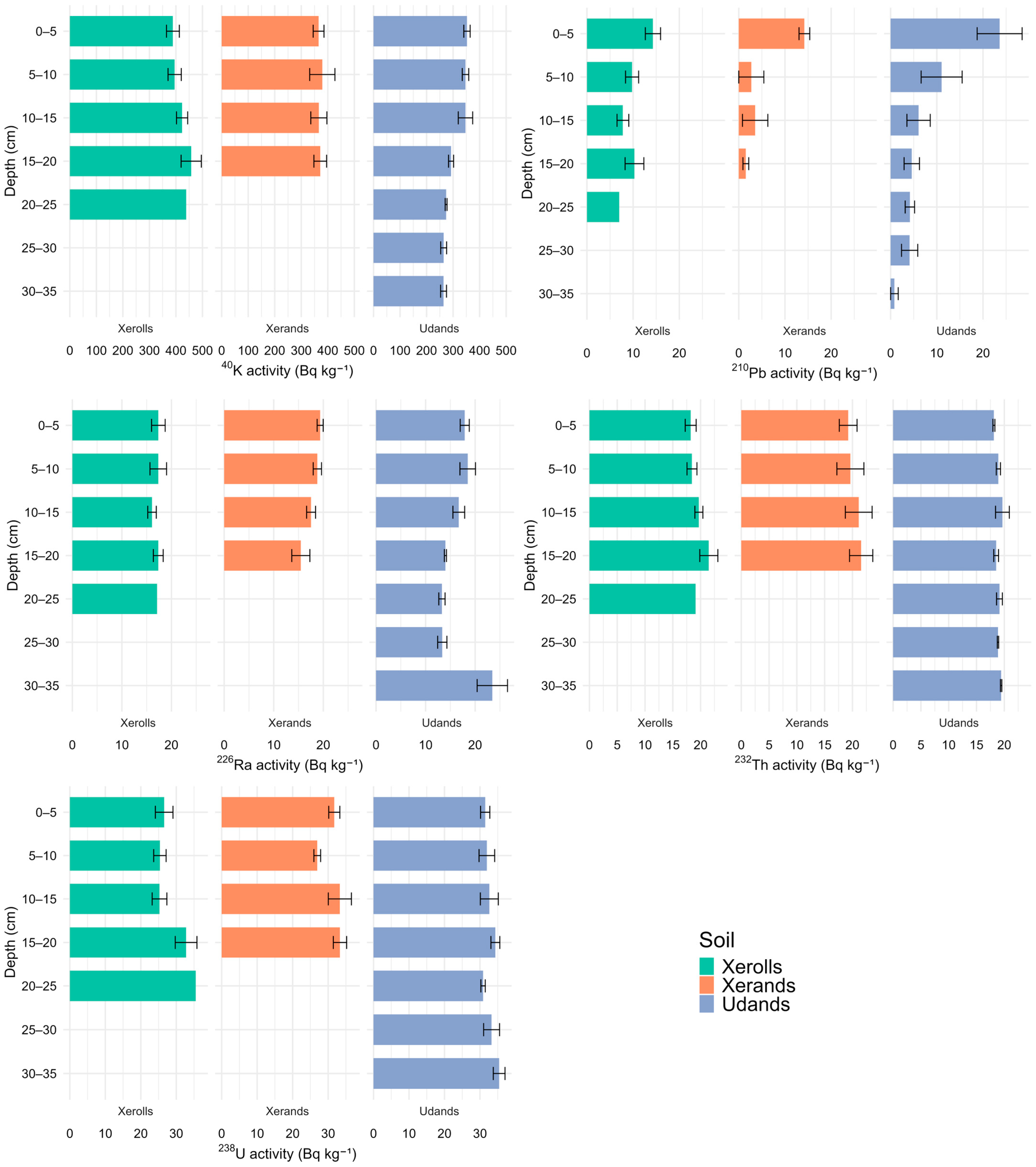
Overall, the mass-specific activity of most radionuclides exhibited a relatively homogeneous vertical distribution across the soil profiles, with the notable exception of 210Pb, which showed a marked decrease with depth (Figure 2). A higher concentration of 210Pb in the top layer is considered to be indicative of natural deposition patterns [40].
In Udands, 40K and 226Ra show a noticeable decline in the activity concentration with depth. The distribution of radionuclides within the soil profile is likely influenced by leaching processes under a high precipitation regime, as precipitation increases soil moisture and water percolation, thereby facilitating the leaching of soluble radionuclides and their associated complexes [31,32]. However, the higher radionuclide content in the uppermost soil layer may be related to the presence of allophane and allophane–organic matter complexes, which can enhance the retention in the surface horizon [13,14,17]. In contrast, Xerolls do not exhibit higher 40K and 226Ra mass-specific activity in the surface layer, which may be attributed to the lower retention capacity of crystalline clays compared to the amorphous aluminosilicates characteristic of Andisols [41]. This reduced retention likely facilitates leaching along the soil profile, even under relatively low precipitation conditions. These findings suggest that precipitation, soil texture, and the type of aluminosilicates present play key roles in controlling the radionuclide distribution within the soil profile.
Furthermore, several radionuclides behave differently in the Mollisols compared to the more humid sites. For instance, 40K, 232Th, and 238U tend to increase with depth, possibly explained by the low soil moisture, which increases gamma radiation emission and promotes greater radioactive release, as gases rise carrying radionuclides [31,32].
Previous studies have shown that 238U tends to be mobile within the soil profile and may even become depleted in surface horizons [9]. However, in our study area, no significant surface depletion was observed. U mobility in soils is strongly influenced by its oxidation state: U (VI) is soluble and can be leached under oxidizing conditions, whereas U (IV) is typically immobile and retained in the solid phase [42]. The absence of surface depletion in 238U observed in our profiles may reflect limited oxidation and leaching, which is consistent with the young age of these soils.
Notably, in Udands, 226Ra shows a maximum mass-specific activity exceeding 26 Bq kg−1 at a depth of 30 cm, potentially linked to a volcanic ash input of different mineralogy incorporated into the soil. Areas affected by volcanic eruptions, especially those located farther from the source, frequently receive new inputs of volcanic ash, and these thin deposits (ranging from millimeters to centimeters in thickness) become incorporated into the existing profile over time [14]. Studies on the historical volcanic record near the study area have identified five tephra deposits over the past five centuries in sediments from Lake Futalaufquen [43].

3.3. 238U/226Ra and 232Th/226Ra Activity Ratios

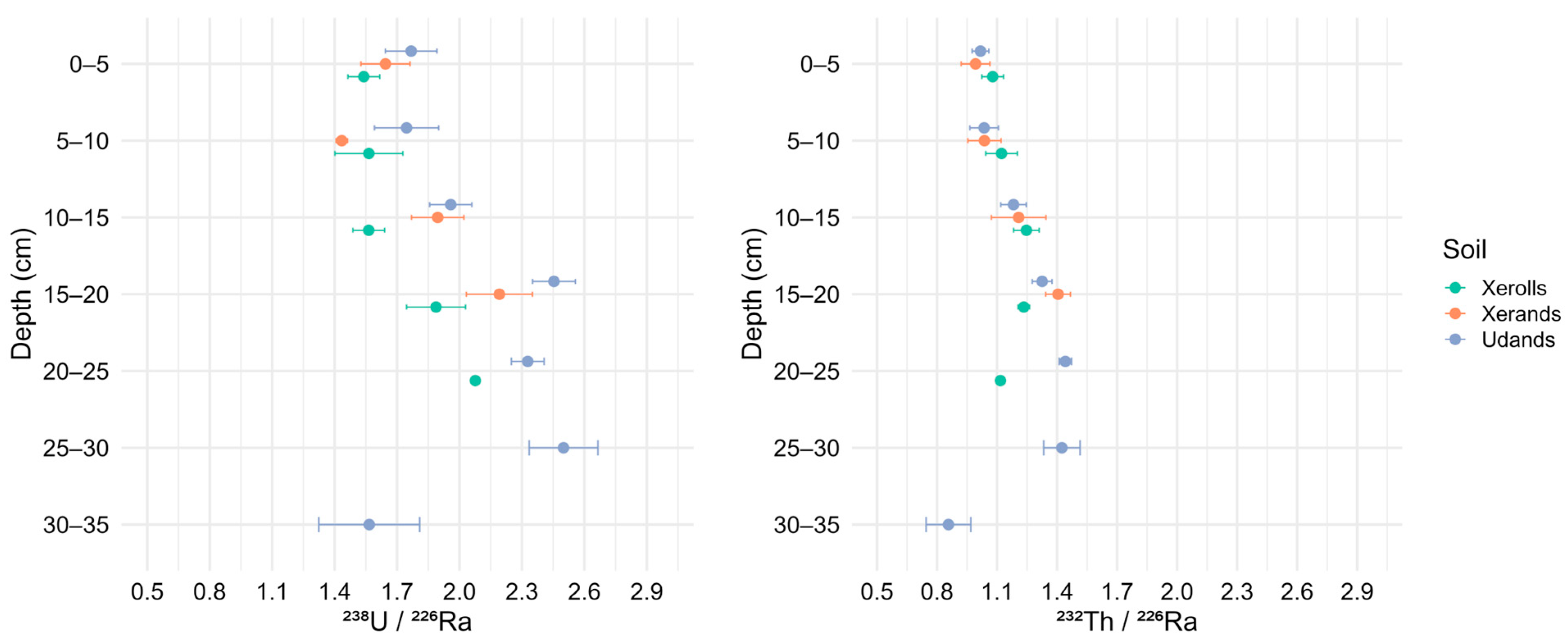
The 238U/226Ra activity ratio along the soil-climate gradient showed mean values of 1.7, 1.8, and 2.0 for Xerolls, Xerands, and Udands, respectively (Figure 3). A 238U/226Ra activity ratio that significantly deviates from 1 indicates radioactive disequilibrium within the 238U decay series. Ideally, if secular equilibrium prevails in the 238U decay chain, the activity ratio of 238U/226Ra would be approximately 1 [10]. The values observed in the study area indicate a clear departure from secular equilibrium, which is consistent with the young age of these soils. The ratio tended to increase with depth, likely due to the differential mobility of these two radionuclides within the soil profile [44]. In contrast, in Udands, the 238U/226Ra ratio markedly decreased at 30 cm depth, coinciding with the previously described increase in 226Ra content, presumably associated with the incorporation of a thin volcanic ash layer of different mineralogy into the soil (Figure 2).
The 232Th/226Ra ratio is used to evaluate whether the proportionality between 232Th and 238U decay series was maintained [45,46]. According to Evans et al. [45], this ratio is around 1.1 in most environmental samples. Consistent with previous studies, the volcanic soils of the study area exhibited mean values close to this reference (ranging from 1.13 to 1.18). However, in Andisols, the ratio tended to increase with depth, reaching values up to 1.6, suggesting that the original proportionality has not been preserved in these soil profiles. The increase in the 232Th/226Ra ratio with depth in soils containing non-crystalline aluminosilicates (imogolite and allophane) may be related to the greater affinity of 232Th for fine particles and soil organic matter compared to 226Ra. Th tends to remain more strongly retained in these fractions, while Ra is more mobile [44].
The activities of 226Ra, 232Th, and 238U were inferred from their gamma-emitting daughters (214Pb, 228Ac, and 234Th, respectively), assuming secular equilibrium. Deviations from unity in activity ratios such as 238U/226Ra and 232Th/226Ra may reflect genuine natural disequilibrium rather than analytical artifacts. In particular, U mobility resulting from weathering, leaching, or geochemical fractionation can lead to measurable discrepancies between the parent and daughter radionuclides. These effects are especially relevant in the studied hillslope soils, where the volcanic origin and subsequent pedogenic evolution have contributed to enhanced radionuclide redistribution.

3.4. Distribution of Soil Radionuclides in Xerolls: The Influence of Topography and Land Use

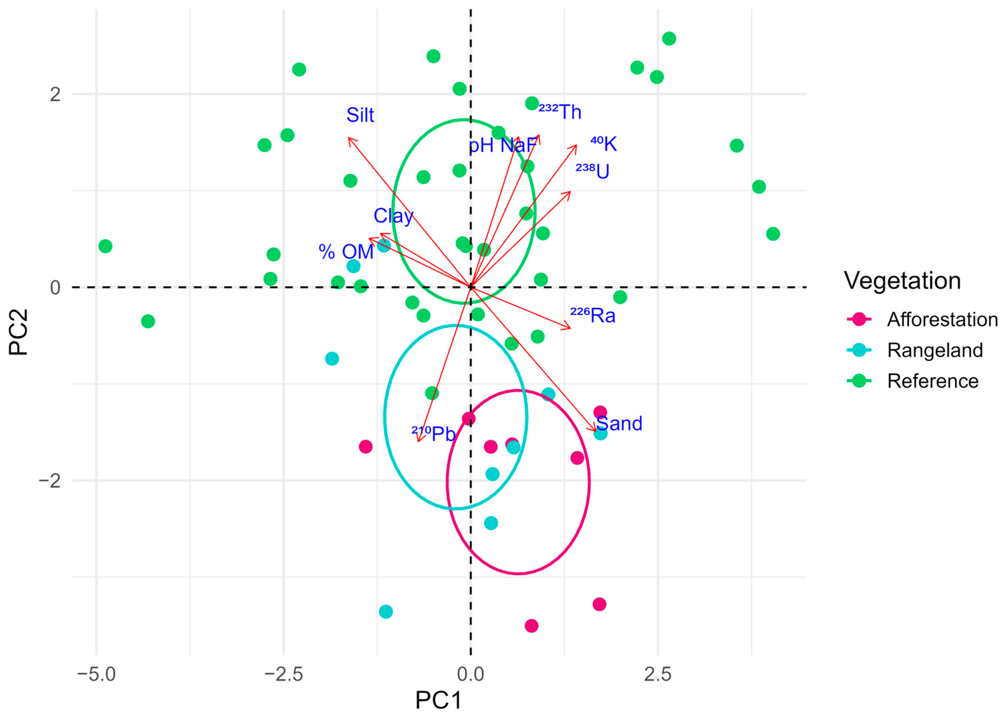
Although the reference soils located in the eastern part of the study area (Xerolls) exhibited considerable variability in both the physicochemical properties and the mass-specific activity of the natural radionuclides (Table 1), they showed clear differences compared to the afforested and rangeland soils located on the hill slopes. As shown by the principal component analysis, reference soils are positioned towards positive values along axis 2. These soils are enriched in fine particles (silt and clay), organic matter, and non-crystalline minerals, as indicated by their higher NaF pH values (Figure 4). In contrast, soils where the native vegetation has been replaced—positioned towards negative values along axis 2—exhibited losses of organic matter, non-crystalline clays, and fine fractions, along with an enrichment in the sand fraction.
These shifts in physicochemical properties indicate ongoing soil degradation processes. The depletion of the finer textural fractions suggests active erosion processes [47,48]. In volcanic soils, erosion has been shown to selectively remove microaggregates enriched in organic matter and fine particles, even without prior dispersion [49,50,51]. Moreover, the observed differences in the NaF pH and organic matter content associated with land use change are likely linked to mineralogical alterations induced by soil desiccation. Drying conditions can disrupt the formation and stability of non-crystalline minerals, promoting their transformation into halloysite-type crystalline phases [19]. This mineralogical transition may reduce the soil’s capacity to stabilize organic matter, thereby enhancing soil carbon mineralization [52].
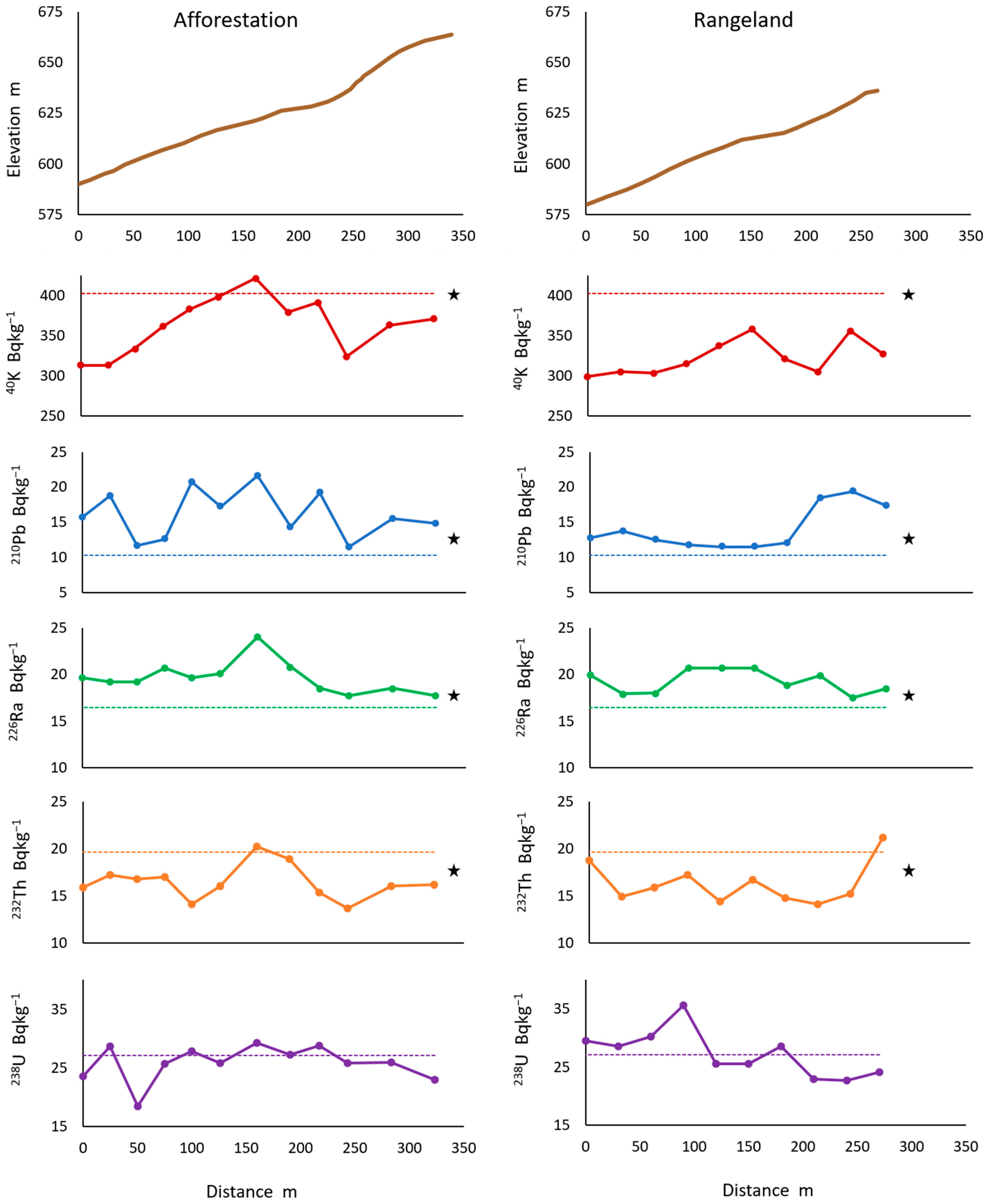
Along the afforested and rangeland hill slopes, the mass-specific activity of the radionuclides varied, diverging from the reference values. Soils on the hill slopes exhibited significantly lower values (p < 0.05) of 40K and 232Th and significantly higher values of 210Pb and 226Ra compared to the reference soils (Figure 5).
Part of the variability in the radionuclide activity can be attributed to the geochemical characteristics of the materials, which are closely associated with the soil texture. Previous studies in the region have reported a strong correlation between the geochemical composition and the particle size distribution, with the sand fraction being particularly enriched in K [53]. Given this, it is expected that the K -rich fraction is also enriched in 40K, as equilibrium exists among the three soil K pools—solution, exchangeable, and fixed—in which 40K is present at approximately 10−2% [2].
In addition, the combination of erosion processes, differential radionuclide mobility, and atmospheric inputs likely contributed to the observed differences.
Along the afforested hill slope, 40K shows a positive correlation with the sand fraction and a negative correlation with organic matter (Table 3A), consistent with the trends observed along the previously discussed edaphoclimatic gradient. The negative correlation between 40K and organic matter also holds for the rangeland (Table 3B), in agreement with findings from other studies on volcanic soils [5].
The depletion of 232Th (Figure 5) could be related to the loss of fine fractions, as this radionuclide is preferentially retained by finer soil particles [3,5,10,12]. 226Ra tends to be more strongly retained in the residual soil after erosion, as it is less mobile than 40K and can be associated with more stable soil fractions. Erosive processes may also remove surface layers and expose horizons with higher 226Ra content, or lead to the concentration of this radionuclide in the remaining soil [54,55]. In the afforested area, both 232Th and 226Ra were positively correlated with NaF pH, suggesting the importance of non-crystalline clays in the retention of these radionuclides [5] (Table 3A).
The enrichment of 210Pb (Figure 5) may be linked to atmospheric deposition. 210Pb and its unsupported fraction (210Pbₑₓ) primarily derive from continuous atmospheric fallout, which can lead to surface accumulation even in eroded soils [55]. 210Pb mass-specific activity showed a positive correlation with slope position in the rangeland (Table 3B), with higher values observed in the upper part of the slope where the soil is protected by native Maytenus boaria trees (Figure 5). In addition, 210Pb showed a significant correlation with the mass-specific activity of 137Cs (Spearman’s ρ = 0.71, p < 0.001), as previously measured in the same soil samples across the rangeland slope [24]. Several studies have demonstrated that the fallout radionuclide 137Cs is effectively mobilized and redistributed in eroded environments [2,56,57].
On the afforested hill slope, lithogenic radionuclides showed a negative relationship with slope steepness (Table 3A). Along the slope with irregular topography, points with gentler gradients—which likely function as depositional zones—are enriched in natural radionuclides (Figure 5). These results are consistent with those of Navas et al. [57], who reported that the spatial patterns of radionuclide distribution were strongly correlated with physiographic features and that gentler slopes exhibited the highest radionuclide activities.
On the evaluated slopes, where the estimated erosion rates exceed 33 t ha−1 yr−1 [24], the results indicate that the erosion processes play a pivotal role in controlling the mobilization and spatial distribution of lithogenic radionuclides.
The results of this study highlight the strong sensitivity of the radionuclide distribution patterns to the parent material, pedogenic processes, and land use, offering a valuable baseline for environmental monitoring in volcanic soil systems.

4. Conclusions

This study presents the first comprehensive assessment of the natural radionuclide activity {238U, 232Th, 40K, 226Ra, and 210Pb) in volcanic ash soils along a west–east bio-edaphoclimatic gradient in the Argentine Patagonian Andes. All measured activities fell within the global background levels and posed no radiological risk to ecosystems or human health.
Distinct spatial patterns emerged across soil types and climatic zones. Radionuclide activity increased with sand content and decreased with organic matter, indicating a strong influence of the parent material and soil texture on the radionuclide distribution.
In sandy Mollisols from the driest sites, 40K and 210Pb activities increased with depth, possibly reflecting enhanced gamma fluxes and limited leaching under dry conditions. In contrast, Udands from more humid zones exhibited decreasing radionuclide activity with depth, consistent with higher leaching potential and surface retention by allophane–organic matter complexes. A notable peak in 226Ra activity below 30 cm suggests a volcanic ash input of different mineralogy within the profiles. Future studies should further investigate the relationship between natural radionuclides and the mineralogy of the ashes.
Activity ratios further support these interpretations: deviations from secular equilibrium in the 238U/226Ra ratio point to the geological youth of the soils, whereas elevated 232Th/226Ra ratios suggest a preferential association of Th with fine particles and organic matter.
Finally, Xerolls under afforestation and rangeland management on hill slopes exhibited losses in fine fractions, organic carbon, and non-crystalline minerals relative to native-vegetation soils—patterns consistent with erosion-driven degradation processes following native vegetation replacement. The spatial distribution of radionuclides along the slopes was strongly associated with topographic features such as slope gradient and position.
These findings provide a valuable baseline for natural radionuclides in volcanic landscapes and underscore the sensitivity of their behavior to both pedogenic processes and land use dynamics. They also offer essential reference information for risk assessment and environmental monitoring programs in similar volcanic landscapes.

Author Contributions

Conceptualization, A.N. and L.L.M.; Methodology, L.L.M., L.G. and A.N.; Formal Analysis, L.L.M., D.G.C., L.G. and A.N.; Investigation, L.L.M., D.G.C., L.G. and A.N. Resources, L.L.M. and A.N.; Writing—Original Draft Preparation, L.L.M. and D.G.C.; Writing—Review and Editing, A.N. and L.G.; Funding Acquisition, L.L.M. and A.N.; Supervision, A.N. All authors have read and agreed to the published version of the manuscript.

Funding

This research was funded by Spanish AEI Project PID2023-1471930B-100, PICT-FONCyT 1715/10, and PICT-FONCyT 3943/19.

Data Availability Statement

The data are available from the corresponding authors upon request.

Conflicts of Interest

The authors declare no conflicts of interest.

References

  1. UNSCEAR. Sources and Effects of Ionizing Radiation; UNSCEAR 2008 Report to the General Assembly with Scientific Annexes; UN: New York, NY, USA, 2011; Volume I, p. 439. ISBN 978-92-1-142274-0. [Google Scholar]
  2. Fujiyoshi, R.; Sawamura, S. Mesoscale variability of vertical profiles of environmental radionuclides (40K, 226Ra, 210Pb and 137Cs) in temperate forest soils in Germany. Sci. Total Environ. 2004, 320, 177–188. [Google Scholar] [CrossRef] [PubMed]
  3. Gaspar, L.; Lizaga, I.; Navas, A. Spatial distribution of fallout and lithogenic radionuclides controlled by soil carbon and water erosion in an agroforestry South-Pyrenean catchment. Geoderma 2021, 391, 114941. [Google Scholar] [CrossRef]
  4. Guillén, J.; Muñoz-Serrano, A.; Baeza, A.S.; Salas, A. Speciation of naturally occurring radionuclides in Mediterranean soils: Bioavailabilty assessment. Environ. Sci. Pollut. Res. 2018, 25, 6772–6782. [Google Scholar] [CrossRef]
  5. Kang, T.W.; Park, W.P.; Han, Y.U.; Bong, K.M.; Kim, K. Natural and artificial radioactivity in volcanic ash soils of Jeju Island, Republic of Korea, and assessment of the radiation hazards: Importance of soil properties. J. Radioanal. Nucl. Chem. 2020, 323, 1113–1124. [Google Scholar] [CrossRef]
  6. Marques, R.; Prudêncio, M.I.; Russo, D.; Cardoso, G.; Dias, M.I.; Rodrigues, A.L.; Reis, M.; Santos, M.; Rocha, F. Evaluation of naturally occurring radionuclides (K, Th and U) in volcanic soils from Fogo Island, Cape Verde. J. Radioanal. Nucl. Chem. 2021, 330, 347–355. [Google Scholar] [CrossRef]
  7. Quindós, L.S.; Fernández, P.L.; Soto, J.; Ródenas, C.; Gómez, J. Natural radioactivity in Spanish soils. Health Phys. 1994, 66, 194–200. [Google Scholar] [CrossRef]
  8. Tzortzis, M.; Tsertos, H. Natural radioelement concentration in the Troodos Ophiolite Complex of Cyprus. J. Geochem. Explor. 2005, 85, 47–54. [Google Scholar] [CrossRef][Green Version]
  9. Pucha, G.; Pérez, M.; Aguay, D.; Chávez, E.; Chávez, N.; Giroletti, E.; Reino, W.; Recalde, C. Soil radioactivity in the highest volcanic region of Northern Andes. J. Environ. Radioact. 2023, 262, 107142. [Google Scholar] [CrossRef]
  10. Navas, A.; Soto, J.; Machín, J. 238U, 226Ra, 210Pb, 232Th and 40K activities in soil profiles of the Flysch sector (Central Spanish Pyrenees). Appl. Radiat. Isot. 2002, 57, 579–589. [Google Scholar] [CrossRef]
  11. Salbu, B.; Lind, O.C.; Skipperud, L. Radionuclide speciation and its relevance in environmental impact assessments. J. Environ. Radioact. 2004, 74, 233–242. [Google Scholar] [CrossRef]
  12. Navas, A.; Soto, J.; Machín, J. Edaphic and physiographic factors affecting the distribution of natural gamma-emitting radionuclides in the soils of the Arnás catchment in the Central Spanish Pyrenees. Eur. J. Soil Sci. 2002, 53, 629–638. [Google Scholar] [CrossRef][Green Version]
  13. Dahlgren, R.A.; Saigusa, M.; Ugolini, F.C. The nature, properties and management of volcanic soils. In Advances in Agronomy; Sparks, D.L., Ed.; Academic Press: San Diego, CA, USA, 2004; Volume 82, pp. 113–182. [Google Scholar] [CrossRef]
  14. McDaniel, P.A.; Lowe, D.J.; Arnalds, O.; Ping, C.L. Andisols. In Handbook of Soil Sciences, 2nd ed.; Huang, P.M., Li, Y., Sumner, M.E., Eds.; CRC Press (Taylor & Francis): Boca Raton, FL, USA, 2012; Volume 1, Properties and Processes, pp. 33.29–33.48. [Google Scholar]
  15. Irsigler, S.Z.; Gerzabek, M.H.; Lüthgens, C.; Zehetner, F. Natural and Artificial Radionuclides in Rocks and Soils of the Galápagos Islands. J. S. Am. Earth Sci. 2025, 165, 105693. [Google Scholar] [CrossRef]
  16. Laclau, P. Los Ecosistemas Forestales y el Hombre en el Sur de Chile y Argentina (Forest Ecosystems and Man in Southern Chile and Argentina); Boletín Técnico No. 34; Fundación Vida Silvestre Argentina: Buenos Aires, Argentina, 1997; 147p. [Google Scholar]
  17. Giménez, J.E. Características y clasificación de suelos volcánicos. In Suelos y Vulcanismo; Imbellone, P., Barbosa, O., Eds.; Asociación Argentina de la Ciencia del Suelo: Buenos Aires, Argentina, 2020; pp. 33–69. [Google Scholar]
  18. Parfitt, R.L.; Saigusa, M.; Cowie, J.D. Allophane and halloysite formation in a volcanic ash bed under different moisture conditions. Soil Sci. 1984, 138, 360–364. [Google Scholar] [CrossRef]
  19. Parfitt, R.L.; Wilson, A.D. Estimation of allophane and halloysite in three sequences of volcanic soils, New Zealand. Catena 1985, 7, 1–8. [Google Scholar]
  20. Colmet Dâage, F.; Marcolin, A.; López, C.; Lanciotti, M.; Ayesa, J.; Bran, D.; Andenmatten, E.; Broquen, P.; Girardin, J.; Cortés, G.; et al. Características de los Suelos Derivados de Cenizas Volcánicas de la Cordillera y Precordillera del Norte de la Patagonia; Convenio INTA–ORSTOM: San Carlos de Bariloche, Río Negro, Argentina, 1988; 167p. [Google Scholar]
  21. Besoain, E. Los suelos. In Suelos Volcánicos de Chile; Toso, J., Ed.; Instituto de Investigaciones Agropecuarias (INIA), Ministerio de Agricultura: Santiago, Chile, 1985; pp. 25–95. [Google Scholar]
  22. La Manna, L.; Buduba, C.G.; Irisarri, J. Suelos volcánicos de la provincia del Chubut. In Suelos y Vulcanismo; Imbellone, P., Barbosa, O., Eds.; Asociación Argentina de la Ciencia del Suelo: Buenos Aires, Argentina, 2020; pp. 333–360. [Google Scholar]
  23. Valenzuela, M.F.; Irisarri, J.A.; Ferro, L.; Buduba, C.G. Caracterización Mineralógica de Suelos Desarrollados sobre Cenizas Volcánicas en el Noroeste de la Provincia del Chubut. In Proceeding of the Actas del XVIII Congreso Argentino de la Ciencia del Suelo, Puerto Madryn, Argentina, 16–19 April 2002. formato digital. [Google Scholar]
  24. La Manna, L.; Gaspar, L.; Tarabini, M.; Quijano, L.; Navas, A. 137Cs inventories along a climatic gradient in volcanic soils of Patagonia: Potential use for assessing medium term erosion processes. Catena 2019, 181, 104089. [Google Scholar] [CrossRef]
  25. Vogel, B.; Rostagno, M.; Molina, L.; Antilef, M.; La Manna, L. Cushion Shrubs Encroach Subhumid Rangelands and Form Fertility Islands along a Grazing Gradient in Patagonia. Plant Soil 2022, 475, 623–643. [Google Scholar] [CrossRef]
  26. Van Cleef, D.J. Determination of 226Ra in soil using 214Pb and 214Bi immediately after sampling. Health Phys. 1994, 67, 288–289. [Google Scholar] [CrossRef]
  27. IRAM-SAGPyA 29571-1; Calidad Ambiental–Calidad del Suelo. Determinación de Materia Orgánica en Suelos. Parte 1, Método de Pérdida por Calcinación. Instituto Argentino de Normalización y Certificación (IRAM): Buenos Aires, Argentina, 2008.
  28. Fieldes, M.P.; Perrot, K.W. The nature of allophane in soils. Part 3. Rapid field and laboratory test for allophane. N. Z. J. Sci. 1966, 9, 623–629. [Google Scholar]
  29. IRAM-SAGyP 29574; Calidad del Suelo. Determinación de pH en Suelo para Uso Agropecuario. Instituto Argentino de Normalización y Certificación (IRAM): Buenos Aires, Argentina, 2021.
  30. De Albuquerque Medeiros Lima, E.; Leal, A.; Da Costa Lauria, D.; Viglio, E.; Ribeiro, F.; Franzen, M. Spatial distributions of natural radionuclides in soils of the state of Pernambuco, Brazil: Influence of bedrocks, soils types and climates. J. Environ. Radioact. 2019, 211, 106046. [Google Scholar] [CrossRef]
  31. Guagliardi, I.; Rovella, N.; Apollaro, C.; Bloise, A.; De Rosa, R.; Scarciglia, F.; Buttafuoco, G. Effects of source rocks, soil features and climate on natural gamma radioactivity in the Crati Valley (Calabria, Southern Italy). Chemosphere 2016, 150, 97–108. [Google Scholar] [CrossRef]
  32. Tchorz-Trzeciakiewicz, D.E.; Kozłowska, B.; Walencik-Łata, A. Seasonal variations of terrestrial gamma dose, natural radionuclides and human health. Chemosphere 2023, 310, 136908. [Google Scholar] [CrossRef] [PubMed]
  33. Vukašinović, I.; Todorović, D.; Životić, L.; Kaluđerović, L.; Đorđević, A. An analysis of naturally occurring radionuclides and 137Cs in the soils of urban areas using gamma-ray spectrometry. Int. J. Environ. Sci. Technol. 2017, 15, 1049–1060. [Google Scholar] [CrossRef]
  34. Lanzo, G.; Basile, S.; Brai, M.; Rizzo, S. Volcanic products of Lipari (Aeolian Islands, Italy): Multivariate analysis of petrographic and radiometric data. Radiat. Meas. 2010, 45, 816–822. [Google Scholar] [CrossRef]
  35. Faure, G. Principles of Isotope Geology, 2nd ed.; Wiley: New York, NY, USA, 1986; p. 589. [Google Scholar]
  36. De Mello, D.C.; Demattê, J.A.M.; De Oliveira Mello, F.A.; Poppiel, R.R.; Silvero, N.E.; Safanelli, J.L.; Schaefer, C.E.G.R. Applied gamma-ray spectrometry for evaluating tropical soil processes and attributes. Geoderma 2021, 381, 114736. [Google Scholar] [CrossRef]
  37. Schaefer, C.; Moquedace, C.; Gomes, L.; Veloso, G.; Francelino, M.; De Souza, J.; Demattê, J.; Fernandes-Filho, E.; De Angeli Oliveira, I.; De Mello, D.; et al. Radiometric and magnetic susceptibility characterization of soil profiles: Geophysical data and their relationship with Antarctic periglacial processes, pedogenesis, and lithology. Catena 2023, 226, 107427. [Google Scholar] [CrossRef]
  38. Rabassa, J. Late Cenozoic Glaciations in Patagonia and Tierra del Fuego. In The Late Cenozoic of Patagonia and Tierra del Fuego; Rabassa, J., Ed.; Elsevier: Amsterdam, The Netherland, 2008; pp. 1–513. [Google Scholar]
  39. Buduba, C.G.; La Manna, L.; Irisarri, J. El suelo y el bosque en la Región Andino Patagónica. In Suelos y Vulcanismo; Imbelloni, P., Barbosa, O., Eds.; Asociación Argentina de la Ciencia del Suelo: Buenos Aires, Argentina, 2020; pp. 361–390. [Google Scholar]
  40. Ramos-Lerate, I.; Lozano-Bermejo, R.; Burneo, J.I.; Armijos, C.; Pinero, M.; Bolívar, J.P.; Gázquez, M.J. Radiological assessment of both unperturbed and agricultural soils from southern Ecuador. J. Agric. Food Res. 2024, 17, 101236. [Google Scholar] [CrossRef]
  41. Wada, K. The distinctive properties of Andosols. In Advances in Soil Science; Stewart, B.A., Ed.; Springer: New York, NY, USA, 1985; Volume 2, pp. 173–229. [Google Scholar]
  42. Cumberland, S.; Douglas, G.; Grice, K.; Moreau, J. Uranium Mobility in Organic Matter-Rich Sediments: A Review of Geological and Geochemical Processes. Earth-Sci. Rev. 2016, 159, 160–185. [Google Scholar] [CrossRef]
  43. Daga, R.; Guevara, S.R.; Arribére, M. New records of late Holocene tephras from Lake Futalaufquen (42.8° S), northern Patagonia. J. S. Am. Earth Sci. 2016, 66, 232–247. [Google Scholar] [CrossRef]
  44. Navas, A.; Machín, J.; Soto, J. Mobility of natural radionuclides and selected major and trace elements along a soil toposequence in the Central Spanish Pyrenees. Soil Sci. 2005, 170, 859–870. [Google Scholar] [CrossRef]
  45. Evans, C.V.; Morton, S.L.; Harbottle, G. Pedologic assessment of radionuclide distributions: Use of a radio-pedogenic index. Soil Sci. Soc. Am. J. 1997, 61, 1440–1449. [Google Scholar] [CrossRef]
  46. Ivanovich, M. Uranium Series Disequilibrium: Concepts and Applications. Radiochim. Acta 1994, 64, 81–94. [Google Scholar] [CrossRef]
  47. Hiraoka, M.; Imamori, N.; Shimizu, T.; Ishida, K.; Yamashita, K.; Kakihara, H. Effect of fine particle content in volcanic ash on slope surface runoff: Laboratory rainfall simulation assuming a slope with thin deposits of ashfall. Int. J. Eros. Control Eng. 2023, 16, 36–48. [Google Scholar] [CrossRef]
  48. Navas, A.; Quine, T.A.; Walling, D.E.; Gaspar, L.; Quijano, L.; Lizaga, I. Relating intensity of soil redistribution to land use changes in abandoned Pyrenean fields using fallout caesium-137. Land Degrad. Dev. 2017, 28, 2017–2029. [Google Scholar] [CrossRef]
  49. Poulenard, J.; Podwojewski, P.; Janeau, J.L.; Collinet, J. Runoff and soil erosion under rainfall simulation of Andisols from the Ecuadorian Páramo: Effect of tillage and burning. Catena 2001, 45, 185–207. [Google Scholar] [CrossRef]
  50. Rodríguez Rodríguez, A.; Arbelo, C.; Guerra, J.; Mora, J. Erosión hídrica en Andosoles de las Islas Canarias. Edafología 2002, 9, 23–30. [Google Scholar]
  51. La Manna, L.; Tarabini, M.; Gomez, F.; Rostagno, C.M. Changes in soil organic matter associated with afforestation affect erosion processes: The case of erodible volcanic soils from Patagonia. Geoderma 2021, 403, 115265. [Google Scholar] [CrossRef]
  52. Hernández, Z.; Almendros, G.; Carral, P.; Álvarez, A.; Knicker, H.; Pérez-Trujillo, J.P. Influence of non-crystalline minerals in the total amount, resilience and molecular composition of the organic matter in volcanic ash soils (Tenerife Island, Spain). Eur. J. Soil Sci. 2012, 63, 603–615. [Google Scholar] [CrossRef]
  53. La Manna, L.; Gaspar, L.; Rostagno, C.M.; Quijano, L.; Navas, A. Soil changes associated with land use in volcanic soils of Patagonia developed on dynamic landscapes. Catena 2018, 166, 229–239. [Google Scholar] [CrossRef]
  54. Le, C.; Huynh, N.; Nguyen, V. Accumulation rates of natural radionuclides (40K, 210Pb, 226Ra, 238U, and 232Th) in topsoils due to long-term cultivations of water spinach (Ipomoea aquatica Forssk.) and rice (Oryza sativa L.) based on model assessments: A case study in Dong Nai province, Vietnam. J. Environ. Manag. 2020, 271, 111001. [Google Scholar] [CrossRef]
  55. Stimac, I.; Rubiano, J.; Arriola-Velásquez, A.; Alonso, H.; Geibert, W.; Tejera, A.; Guerra, J.; Cámara, F.; Martel, P. 226Ra, 228Ra and 40K as tracers of erosion and accumulation processes: A 3-year study on a beach with different sediment dynamics. Catena 2021, 204, 105705. [Google Scholar] [CrossRef]
  56. Maloș, C.; Kovács, T.; Savin, C.; Veres, D.; Muntean, O.; Kelemen, S.; Begy, R. Investigation of the effect of anthropogenic land use on the Pănăzii Lake (Romania) catchment area using Cs-137 and Pb-210 radionuclides. PLoS ONE 2021, 16, e0251603. [Google Scholar] [CrossRef]
  57. Navas, A.; Gaspar, L.; López-Vicente, M.; Machín, J. Spatial distribution of natural and artificial radionuclides at the catchment scale (South Central Pyrenees). Radiat. Meas. 2011, 46, 261–269. [Google Scholar] [CrossRef]
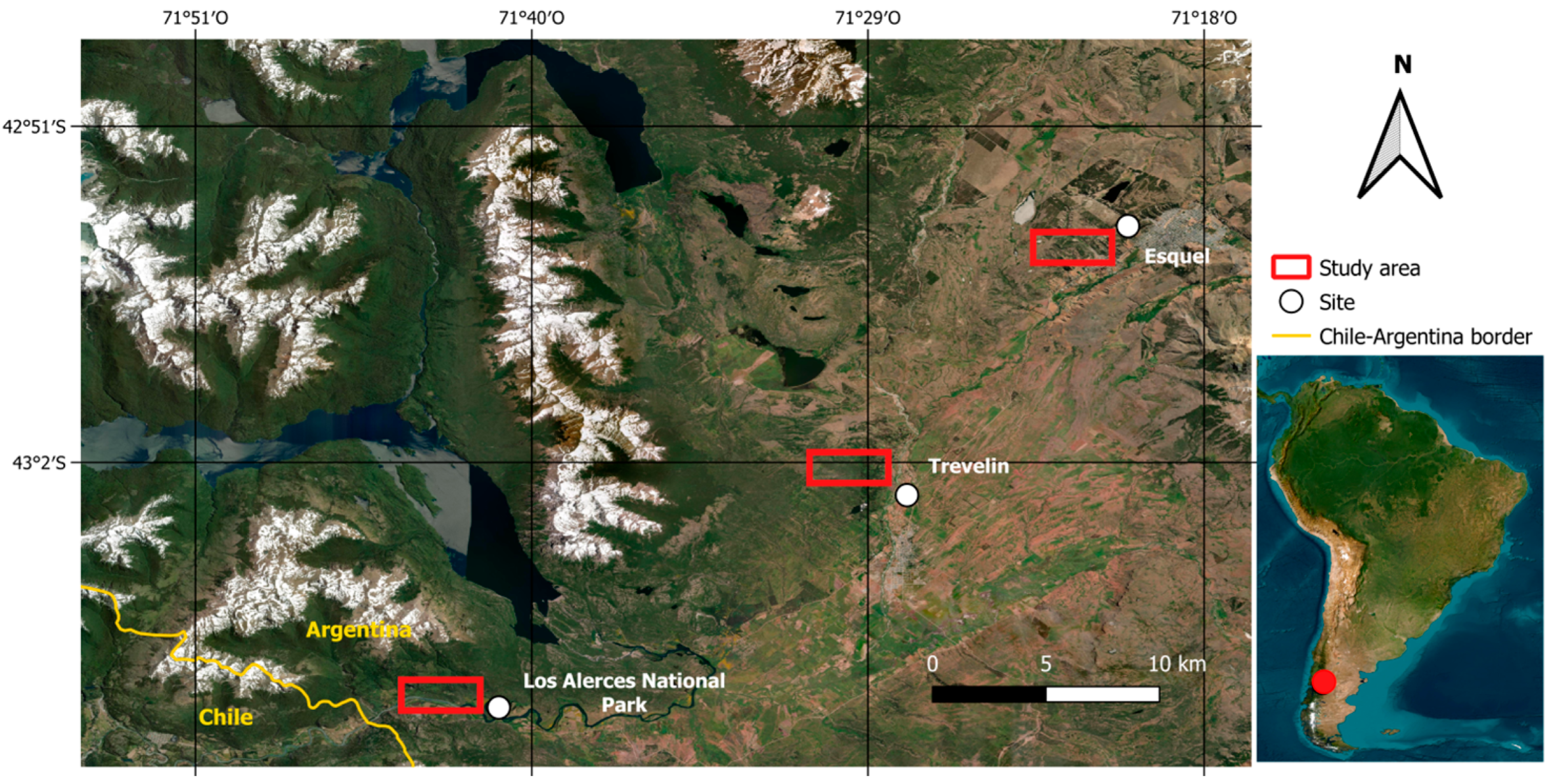
Figure 1. Location of the study area. The map on the right depicts the study area within South America, while the map on the left shows the sampling site locations within the study area. Satellite imagery from Esri Satellite (available at https://server.arcgisonline.com/ArcGIS/rest/services/World_Imagery/MapServer/tile/{z}/{y}/{x}; accessed on 5 August 2025).
Geosciences 15 00348 g001
Figure 2. Vertical distribution of natural radionuclides in soil profiles across the edaphoclimatic gradient.
Geosciences 15 00348 g002
Figure 3. Vertical distribution of 238U/226Ra and 232Th/226Ra activity ratios in the studied soil profiles.
Geosciences 15 00348 g003
Figure 4. Biplot of the principal component analysis (PCA) based on the first two components. PCA was performed using radionuclide mass-specific activity, particle size distribution, pH in NaF, and organic matter content (OM %) from soil profiles sampled along a longitudinal transect in the Andean Patagonia, Argentina. Arrows represent the eigenvectors of the soil properties. Sample plots are color-coded according to land use type, and confidence ellipses highlight the clustering of samples based on their multivariate similarity.
Geosciences 15 00348 g004
Figure 5. Topography and natural radionuclide activity along hill slopes under different land uses: afforestation and rangeland. The grey line indicates the mean value for the reference Xerolls. ★ denote significant differences (p < 0.05) compared with the reference soils.
Geosciences 15 00348 g005
Table 1. Summary statistics for environmental radionuclide activity and selected soil properties in the analyzed samples. Mean ± standard error is presented, with ranges in brackets. p-values are from ANOVA tests; significant differences (p < 0.05) are shown in bold (N = 25).
Soils Clasification *XerollsXerandsUdands
SiteEsquelTrevelinLos Alerces National Park
Precipitation
(mm year−1)
7509501400
Radionuclides mass-specific activity (Bq Kg−1)p value
40K402.7 ± 21.6 b
(276–545)
368.2 ± 14.3 ab
(323–413)
299.7 ± 8.5 a
(270–320)
0.028
210Pb10.3 ± 0.9 b
(3–17)
4.9 ± 0.6 a
(2–6)
6.7 ± 1.9 ab
(3–14)
0.011
226Ra16.5 ± 1.0
(11–22)
19.0 ± 1.5
(17–25)
17.3 ± 2.2
(12–25)
0.455
232Th19.6 ± 0.6
(17–25)
19.9 ± 1.1
(17–24)
17.0 ± 0.2
(16–17)
0.062
238U27.1 ± 2.0
(14–38)
32.5 ± 1.0
(30–35)
29.1 ± 1.3
(25–33)
0.250
Soil propertiesp value
Organic matter (%)10.8 ± 0.8
(4–22)
12.5 ± 1.3
(6–19)
13.3 ± 0.6
(10–22)
0.076
pH H2O6.6 ± 0.1 b
(5.6–7.6)
5.9 ± 0.1 a
(5.7–6.2)
5.9 ± 0.1 a
(5.5–6.1)
<0.001
pH NaF (2 min)8.2 ± 0.1 a
(7.3–9.1)
8.9 ± 0.1 b
(8.0–9.9)
10.3 ± 0.1 c
(9.1–10.9)
<0.001
pH NaF (60min)8.8 ± 0.1 a
(7.7–9.7)
9.8 ± 0.2 b
(9.0–10.7)
11.2 ± 0.1 c
(10.4–11.4)
<0.001
Clay (%)4.8 ± 0.3 a
(2–9)
9.7 ± 0.7 b
(7–16)
4.8 ± 0.2 a
(4–7)
<0.001
Silt (%)36.8 ± 2.1 a
(13–64)
51.7 ± 1.7 b
(41–64)
47.5 ± 0.9 b
(39–55)
<0.001
Sand (%)58.5 ± 2.3 c
(31–84)
38.7 ± 1.6 a
(28–49)
47.7 ± 1.0 b
(40–57)
<0.001
* Xerolls, Xerands, and Udands reflect a pedogenetic gradient characterized by clay minerals of decreasing crystallinity: halloysite, imogolite, and allophane, respectively. The volcanic ash-derived soils in the study area are loose, have medium to coarse textures, and exhibit A/Bw/C or A/AC/C horizon sequences. Details of the soil profiles are described in [24].
Table 2. Spearman correlations between the mass-specific activity of natural radionuclides and soil physicochemical properties in the study area: (A) Entire soil profile (N = 68); (B) Top 15 cm only (N = 48). Significant correlations (p < 0.05) are highlighted: blue for positive, green for negative.
(A)40K210Pb226Ra232Th238U
Sand0.6080.4720.3000.3410.267
Silt−0.671−0.452−0.369−0.412−0.344
Clay−0.006−0.4260.071−0.1790.043
pH H2O0.0840.437−0.2950.415−0.332
pH NaF 2′−0.730−0.393−0.259−0.521−0.146
pH NaF 60′−0.511−0.5020.043−0.3140.184
Organic matter−0.744−0.016−0.338−0.531−0.53
(B)40K210Pb226Ra232Th238U
Sand0.573−0.1500.1570.1980.150
Silt−0.5900.183−0.191−0.236−0.177
Clay−0.2990.042−0.076−0.098−0.102
pH NaF 2′−0.351−0.158−0.0140.0230.304
pH NaF 60′−0.237−0.1890.1500.1630.427
Organic matter−0.6330.426−0.114−0.475−0.107
Table 3. Spearman correlation between the mass-specific activity of natural radionuclides, soil physicochemical properties, and topographic features in Xerolls from the easternmost sector, under different land uses: (A) pinus afforestation; (B) rangeland. Significant correlations (p < 0.05) are highlighted: blue for positive, green for negative.
(A) Afforestation
Properties40K210Pb226Ra232Th238U
Sand0.8570.3990.4100.2310.299
Silt−0.887−0.406−0.359−0.204−0.294
Clay−0.793−0.424−0.433−0.256−0.274
pH NaF 2′−0.353−0.0040.4990.601−0.007
pH NaF 60′−0.404−0.0720.5570.4640.061
Organic matter−0.495−0.003−0.1930.001−0.358
Slope position0.445−0.042−0.413−0.1900.108
Slope gradient−0.441−0.412−0.278−0.328−0.072
(B) Rangeland
Properties40K210Pb226Ra232Th238U
Sand−0.019−0.2030.360−0.3430.094
Silt0.0090.277−0.4190.303−0.131
Clay0.2860.120−0.3500.417−0.164
pH NaF 2′0.119−0.1560.179−0.268−0.099
pH NaF 60′0.066−0.4260.185−0.3060.218
Organic matter−0.6580.528−0.5030.065−0.087
Slope position0.4990.593−0.3190.012−0.808
Slope gradient−0.3370.164−0.061−0.3740.008
Disclaimer/Publisher’s Note: The statements, opinions and data contained in all publications are solely those of the individual author(s) and contributor(s) and not of MDPI and/or the editor(s). MDPI and/or the editor(s) disclaim responsibility for any injury to people or property resulting from any ideas, methods, instructions or products referred to in the content.