1. Introduction
The morphology and internal architecture of dunes formed in direct association with cliffs offer a unique window into the geomorphological and sedimentary processes governing coastal aeolian systems. These formations serve not only as records of past environmental and climatic conditions but also as indicators of the complex interplay between wind dynamics, topography, sea-level fluctuations, sediment supply and vegetation [
1,
2,
3].
Cliff-front and clifftop dune systems have been documented across a range of geographic and climatic settings. In the Western Mediterranean, similar lithified aeolian systems have been described in Sardinia [
2], Ibiza [
4], and southeastern Mallorca [
5], where carbonate platforms exposed during glacial sea-level lowstands provided accommodation space for dune formation. Other notable examples include the high-relief dune systems of Dakhla, Morocco [
6], beach–climbing–clifftop dune transitions in Poland [
7], and expansive clifftop aeolianites in the Great Australian Bight [
3].
Beyond Mediterranean contexts, similar morpho-sedimentary structures are found in drylands and desert margins. Climbing dunes on the Qinghai–Tibet Plateau [
8] and sand ramps in the Mojave Desert [
9] illustrate the role of wind–topography interaction in dune architecture. These processes have also been explored through experimental studies and wind tunnel simulations [
10,
11], which demonstrate how airflow accelerates at cliff edges, enhancing landward sediment flux and forming steep climbing or echo dunes [
12,
13].
Recent work has emphasised the complex stratigraphy that results from dune interactions and reactivation phases [
14], often linked to climatic oscillations or anthropogenic influences [
15,
16]. These dynamics, particularly in carbonate coastal settings, remain underexplored despite their significance in reconstructing Quaternary palaeo environments.
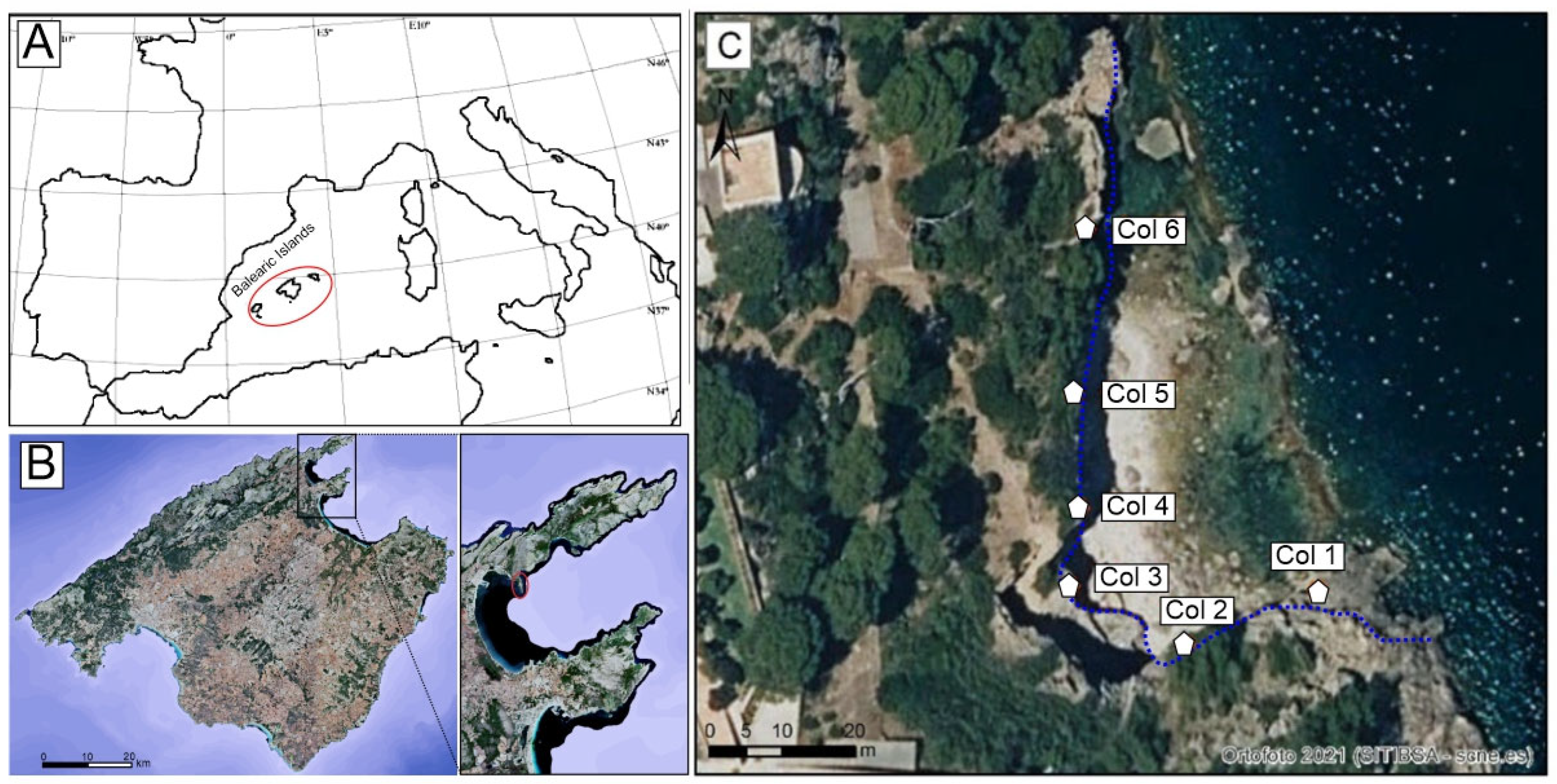
The present study focuses on a well-preserved Late Pleistocene cliff-front dune at Sa Fortalesa (northeastern Mallorca) (
Figure 1A), directly attached to Jurassic limestone. This site provides an ideal opportunity to examine how sedimentary architecture and morphodynamics reflect the interaction of palaeowind variability, topographic confinement, and falling sea levels. Unlike previous examples from the island, the Sa Fortalesa dune developed within a semi-enclosed bay, offering insights into wind-funnelling effects and sediment accumulation in topographically constrained settings.
Through detailed facies analysis, grain size measurements, and palaeowind reconstructions, our objective is to reconstruct the evolutionary stages of this dune system and to assess the broader environmental controls governing its development. In doing so, we aim to contribute to the global understanding of cliff-front dune formation and their value as proxies for Late Quaternary climate and sea-level changes.
3. Methods
Fieldwork was conducted along the flanks and face of the abandoned coastal quarry, which provides excellent exposures of the aeolian sequence. Stratigraphic columns were constructed based on these exposures, and sedimentary units were systematically described and classified according to their lithological characteristics, sedimentary structures, and biogenic content. Deposits were grouped into facies types, including conglomerates (C), breccias (B), sandstones (S), and silts (P), and further categorised based on dominant grain texture (a: sand, m: mud, s: silt), grain size (c: cobbles, d: gravel, e: medium to very coarse sand, h: fine to medium sand), sedimentary structures (l: laminated, p: planar-stratified, t: cross-bedded, u: low-angle-stratified, g: graded, n: massive), and biological features (f: highly fossiliferous, r: root traces). Stratigraphic codes such as “Sht” are employed to concisely represent composite lithofacies based on the classification scheme described above. For instance, “Sht” designates a sandstone (S) composed of fine to medium sand (h) and displaying cross-bedded structures (t). This nomenclature allows for the efficient encoding of sedimentary attributes within stratigraphic logs.
The three-dimensional architectural framework of the dune deposits was examined using the stratigraphic relationships revealed by quarry exposures. The orientation and dip of aeolian strata were measured to infer palaeowind direction and its temporal evolution. These interpretations were informed by comparison with previous experimental studies on bedform alignment in bidirectional flows [
11] and airflow dynamics over dune lee faces [
12].
To evaluate the aeolian dynamics, potential sediment transport was estimated using the empirical equation proposed by [
18], which accounts for grain size, air density, gravitational acceleration, and shear velocity. The equation is expressed as
where
k is a constant (4.2),
ρ is air density (1.25 kg m
−3),
g is the gravitational acceleration (9.81 m s
−2),
D is the mean sediment grain diameter,
Dref is a reference grain size (0.25 mm), u
0 is the shear velocity, and
ut is the threshold shear velocity for sediment mobilisation (an empirical coefficient, usually 0.1).
Threshold wind velocities were further evaluated using Bagnold’s (1941) [
19] equation, modified to estimate the critical friction velocity (
ut) necessary to initiate particle movement. The parameters include sediment density (2.650 kg m
−3), air density, grain size (D
50), and a constant A = 0.085, applicable during active saltation [
20].
Grain size analysis was performed using hand samples (5 × 5 cm), extracted from stratigraphic levels considered representative of each sedimentary facies. The selection of sampling points was based on detailed field observations aimed at capturing the internal variability of each unit. Key criteria included visible differences in grain sorting, sedimentary structure (e.g., cross-bedding, lamination), colour, cementation degree, and the presence of biogenic content such as marine fossils or root traces. Samples were preferentially taken from undisturbed sections that preserved primary depositional features and avoided zones affected by weathering or secondary alteration. This targeted approach ensured that the analysed samples accurately reflected the range of textural and compositional characteristics present within each unit. A digital optical microscope (HITACHI S-3400N e) was employed to capture high-resolution images, from which grain size parameters (including the major axis of 100 grains per sample) were determined using ImageJ.ink (Version 1.54p), a free digital image analysis software. This methodology provided the basis for calculating the mean grain size for each sedimentary unit, enabling further correlation with inferred palaeowind conditions.
4. Results and Discussion
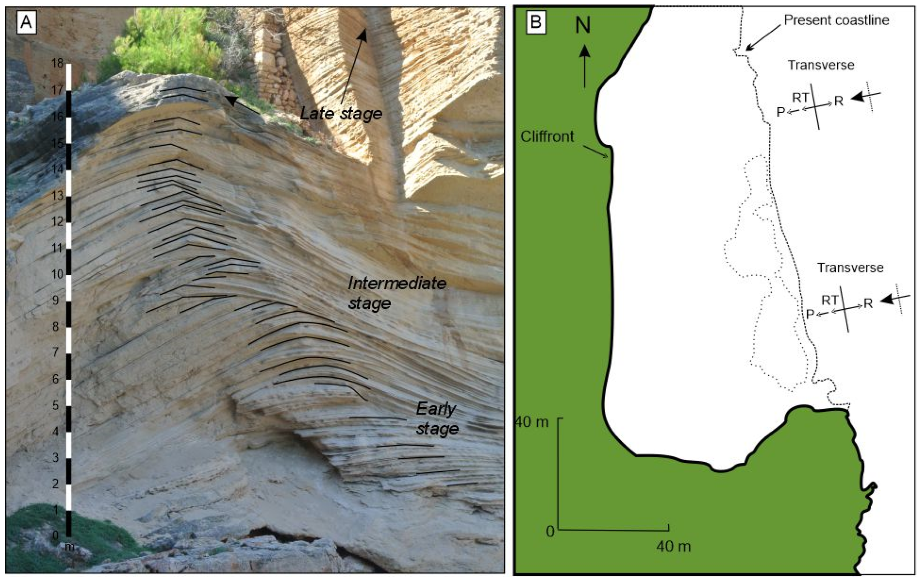
At Sa Punta de Sa Fortalesa (Pollença, northeastern Mallorca), a stratigraphic sequence comprising six distinct sedimentary units (U1–U6) has been documented. Among these, Unit U4 is particularly noteworthy due to the presence of a prominent cliff-front dune with a well-defined crest and complex internal architecture (
Figure 2) (see [
17]).
Unit U1, located at the base of the sequence, consists of colluvial deposits composed of heterometric clasts ranging from 2 to 16 cm in diameter. These clasts are matrix-supported and exhibit imbrication, indicating transport from land towards the sea. This unit reaches a maximum thickness of approximately 50 cm, although it is predominantly developed in the central part of the outcrop. Overlying this, Unit U2 is composed of well-cemented medium sands (250–500 µm) with a pale brown colouration and tabular stratification. It reaches a thickness of up to 1.5 m and contains occasional angular to sub-angular clasts.
Unit U3 is exposed only at the westernmost margin of the quarry and comprises 1.0–1.7 m thick, massive to crudely stratified beds of fine- to medium-grained bioclastic sand interlayered with well-rounded gravel lenses. A sharp erosional basal contact truncates the underlying colluvial Unit U2. The high abundance of marine fossils (bivalves, gastropods, echinoid fragments), together with the rounded character of the gravel, suggests reworking in a high-energy shallow-marine setting. We therefore reinterpret Unit U3 as a Last Interglacial (MIS 5e) shoreface to upper-beach deposit that became lithified prior to the advance of the cliff-front dune. Its presence provides a time marker that constrains the onset of aeolian sedimentation to the succeeding glacial sea-level fall (MIS 4–3).
Unit U4, the focal point of this study, consists of moderately cemented calcarenites composed of fine to medium sands (125–250 µm) alternating with medium to coarse sands (250–500 µm), ranging in colour from pale brown to white. This unit displays prominent cross-bedding and is interpreted as the main aeolian dune accumulation. It has been subdivided into three subunits, corresponding to successive stages of the dune.
The lower subunit (early stage) forms a broad parabolic dune body, 6–10 m thick, with gentle foresets indicating initial sediment accumulation.
The intermediate subunit comprises smaller climbing dunes with sharply defined crests and a thickness of approximately 5.5 m. This stage reflects intensified wind flow and sediment supply.
The upper subunit (final stage) represents the latest phase of accumulation, with well-developed crests reaching 9 m in thickness. This stage records sustained aeolian activity, as evidenced by thicker cross-stratified sets (
Figure 3A).
Unit U5 forms a discontinuous, 1.0–2.4 m thick drape of reddish-brown, poorly sorted silt to sandy silt with abundant angular to sub-angular limestone clasts (1–20 cm). The unit mantles the lee side and flanks of the dune preserved in Unit U4 and locally infills small gullies incised into the dune surface. The massive to weakly stratified texture, clast fabric and matrix support indicate rapid gravitational emplacement rather than aeolian deposition. We interpret Unit U5 as a colluvial wedge produced by rock-fall and slope wash from the overhanging Jurassic cliff during episodes of increased moisture and vegetation loss in the terminal Pleistocene. This post-aeolian veneer records a shift from wind-dominated to slope-dominated processes as the climate became wetter and the sand supply diminished.
The spatial distribution and orientation of foresets within Unit U4 reveal a progressive seaward advance of dune migration towards the cliff face. This spatial evolution is further supported by plan-view observations, which document a transition from relatively straight or gently undulating dune crests during early stages to more strongly curved forms in later stages, following a general NNE–SSW alignment.
Grain size analysis, integrated with wind-flow reconstruction, confirms a close correlation between grain size and interfered palaeowind velocities. The precise relationship between wind speed and sand grain size can vary depending on factors such as the composition of the sand, air humidity, the area’s topography, and the density (mineralogical composition) of the sediments (bioclasts vs. lithoclasts, among others).
Under typical conditions—sand grain density of ~2.7 g/cm
3, grain size of 250 µm, and humidity of 78%, with wind speed measured at 1 m above the surface (since surface-level wind speed can be lower, even around 4 m/s, but anemometers are rarely placed that low) —a wind speed of at least 8–10 m/s is generally required to initiate the movement of medium sand, and 4–6 m/s for fine sand [
22]. Wind speeds below 4 m/s rarely mobilise sediments [
23]. Additional factors such as vegetation cover can also influence local wind effectiveness.
However, unlike most previous studies—which typically assume siliclastic compositions with an average grain density of ~2.33 g/cm3—the aeolianites of Punta de s’Avançada are predominantly composed of bioclastic carbonates, which have a higher grain density of approximately 2.71 g/cm3. This difference in density can affect the threshold wind speeds required for sediment transport. In our calculations, we have accounted for this compositional difference, acknowledging its potential impact on the initiation of particle motion.
Currently, wind speeds in the study area reach approximately 7–8 m/s for several weeks during the winter season.
Based on sediment texture and composition, the early stage of dune development is associated with coarser sands (average ~400 µm) and required sustained wind speeds of approximately 10 m/s from the north-northeast to move the sediment towards the south-southwest (SSW). The intermediate stage corresponds to finer grains (125–250 µm) and wind velocities ranging from 5 to 8 m/s from the east-northeast, where the sediment moved towards the west-southwest (WSW), influenced by topographic deflection. In the final stage, sediment grain sizes range from 180 to 450 µm, with average wind speeds of around 7 m/s from the east, moving the sediment towards the west (W), with occasional peaks up to 10 m/s.
These observations are summarised in
Table 1, which presents the relationship between average wind speed, grain size, and dominant wind direction across the three stages of Unit U4’s development.
The morphological and sedimentological features of the cliff-front dune system at Sa Fortalesa closely parallel those described in southeastern Mallorca by [
1,
5], despite the contrasting structural contexts of the two sites. While Sa Fortalesa is located in a semi-enclosed setting associated with Jurassic limestone cliffs in northern Mallorca, the southeastern cliff-front systems are developed along Miocene carbonate cliffs within broader embayments. Nevertheless, both settings reveal a comparable evolutionary pattern.
In both cases, the dune systems exhibit a three-stage developmental sequence: an initial accumulation phase with deposits located at some distance from the cliff, an intermediate stage marked by the formation of climbing dunes influenced by channelised wind flow, and a final stage characterised by dune crests that prograde toward and eventually reach the cliff face. This morphological evolution is particularly well documented by [
1], who noted the progressive landward migration of the brinkline and an increase in the angle of climb, reaching supercritical values up to 50° during the late phase of dune growth.
Wind regime reconstructions from Sa Fortalesa further reinforce this parallel. Both sites experienced dominant winds from the eastern and southeastern quadrants, with dune crest orientation and foreset architecture adapting to the local embayment geometry. As shown by [
5], the curvature of the cliffline played a pivotal role in steering airflow and, consequently, the orientation of sedimentary structures. A similar curvature-related variation in brinkline morphology is evident at Sa Fortalesa, where early dune stages display relatively straight crestlines that evolve into more strongly curved forms during later stages.
Another significant point of convergence is the presence of early lithification features and reactivation surfaces, indicative of episodic dune stabilisation and remobilisation. As interpreted by [
5], such alternations may reflect rapid climatic oscillations, possibly linked to millennial-scale variability during Oxygen Isotope Stage 3. These findings are consistent with the cyclic nature of dune growth and colluvial deposition observed at Sa Fortalesa.
Overall, despite differing geomorphological settings, the similarities in stratigraphic architecture, wind dynamics, and evolutionary trajectories suggest that cliff-front dune systems in Mallorca are governed by a shared set of controlling mechanisms: topographic confinement, directional wind regimes, sediment supply, and climate-driven environmental fluctuations. This correspondence underscores the potential of Mallorca’s coastal aeolian archives as valuable proxies for reconstructing Late Pleistocene palaeoclimatic and palaeoenvironmental conditions in the Western Mediterranean.
Cliff-front and clifftop dune systems respond to comparable controls worldwide. In southern Australia, expansive clifftop dunes formed as coastal retreat exposed platforms vulnerable to aeolian processes [
3]. In Dakhla (Morocco), a beach–climbing dune–clifftop dune transect exhibits significant wind acceleration (~+250%) at the scarp edge and strong sediment flux directed landward [
7]. Within the Mediterranean context, Cala Xuclar (Ibiza) displays similar cliff-attached dunes formed during Pleistocene sea-level lowstands [
4], and Alghero (Sardinia) preserves lithified Pleistocene cliff-front dune systems dated to ~75 ka, showing morphological and stratigraphic parallels to the Sa Fortalesa site [
2].


