Review

Advancements in Remote Sensing for Monitoring and Risk Assessment of Glacial Lake Outburst Floods

by
Serik Nurakynov
1,
Nurmakhambet Sydyk
1,*,
Zhaksybek Baygurin
1,2 and
Larissa Balakay
1
1
Institute of Ionosphere, Almaty 050000, Kazakhstan
2
Department of Surveying and Geodesy, Satbayev University, Almaty 050000, Kazakhstan
*
Author to whom correspondence should be addressed.
Geosciences 2025, 15(6), 211; https://doi.org/10.3390/geosciences15060211
Submission received: 1 April 2025 / Revised: 27 May 2025 / Accepted: 1 June 2025 / Published: 5 June 2025
(This article belongs to the Special Issue Hydrological Processes and Climate Change in Eurasia)

Abstract

:
Glacial Lake Outburst Floods (GLOFs) have emerged as a critical threat to high-mountain communities and ecosystems, driven by accelerated glacier retreat and lake expansion under climate change. This review synthesizes advancements in remote sensing technologies and methodologies for GLOF monitoring, risk assessment, and mitigation. Through a Preferred Reporting Items for Systematic reviews and Meta-Analyses (PRISMA)-guided systematic literature review and bibliometric analysis of studies from 2010 to 2025, we evaluate the transformative role of remote sensing in overcoming traditional field-based limitations. Central to this review is the exploration of multi-sensor data fusion for high-resolution lake dynamics mapping, machine learning algorithms for predictive risk modelling, and hydrodynamic simulations for flood propagation analysis. This review underscores the importance of these technologies in improving GLOF risk assessments and supporting early warning systems, which are crucial for safeguarding vulnerable high-mountain communities. It addresses existing challenges, such as data integration and model calibration, and advocates for collaborative efforts between scientists, policymakers, and local stakeholders to translate technological advancements into effective mitigation strategies, ensuring the sustainability of these at-risk regions.

1. Introduction

GLOFs have emerged as one of the most critical natural hazards in high mountain regions worldwide. These catastrophic events, characterized by the sudden release of water from glacial lakes, pose a severe threat to downstream communities, infrastructure, and ecosystems [1]. Driven by accelerated glacier retreat and the rapid expansion of glacial lakes under changing climatic conditions, GLOFs have become increasingly frequent and destructive [2,3]. The growing number, size, and volume of glacial lakes, coupled with the instability of their natural dams, have heightened the risk of dam failure, leading to devastating floods with far-reaching impacts [4]. GLOFs have been documented for centuries, yet their frequency and magnitude have increased in recent decades as a direct consequence of accelerating glacier retreat driven by climate change [5].
The significance of GLOFs lies in their potential to cause widespread devastation. Downstream ecosystems are particularly vulnerable to the sudden influx of water and sediment, which can alter aquatic habitats, disrupt riparian vegetation, and change water chemistry [6]. For human communities, the consequences of GLOFs can be dire. Floodwaters can destroy roads, bridges, agricultural fields, and hydroelectric infrastructure, leading to substantial economic losses. In some cases, entire villages have been swept away, resulting in significant loss of life [7]. Historical records and recent assessments indicate that GLOFs have caused substantial damage in regions such as High Mountain Asia (HMA), the Andes, and the European Alps [8,9,10].
The socio-economic impacts of GLOFs are particularly pronounced in densely populated regions like HMA, where millions of people live in close proximity to glacial lakes. Recent events, such as the 2023 South Lhonak GLOF in Sikkim, India, and the 2016 Gongbatongsha GLOF in the Tibetan Himalayas, underscore these risks [11,12]. The South Lhonak outburst destroyed critical infrastructure, including roads and hydropower projects, displacing a large number of people and causing great economic losses, while the Gongbatongsha flood inundated villages and agricultural land, disrupting livelihoods for thousands. Even modest flood events can have dramatic consequences in these areas, where infrastructure is often inadequate to withstand the force of a GLOF [13]. Moreover, the long-term impacts of GLOFs on water resources, agriculture, and energy production can exacerbate existing vulnerabilities, particularly in developing countries where adaptive capacity is limited [14]. As the number and size of glacial lakes continue to grow under the influence of climate change, the potential hazard posed by GLOFs is expected to increase, making them a critical subject of study for disaster risk reduction and management [15].
Climate change is the primary driver behind the dramatic changes observed in glacial environments over recent decades [16]. Global warming has led to increased glacier melting, resulting in the retreat of glacier fronts and the consequent formation and expansion of glacial lakes [17]. The sensitivity of glaciers to temperature variations means that even small increases in average temperatures can lead to substantial ice loss [18]. As glaciers retreat, the over-deepened bedrock is exposed, creating ideal conditions for the accumulation of meltwater in the form of glacial lakes [2].
This dynamic has profound implications for GLOF hazards. With more glacial lakes forming and existing lakes expanding in size, the potential for dam failure increases significantly. Moreover, the feedback mechanisms associated with lake expansion—such as reduced albedo and enhanced meltwater production—can further accelerate glacier retreat [18,19]. These changes are not uniform across regions; some areas, such as High Mountain Asia (HMA) and the Karakoram, exhibit unique behaviors. In some parts of the Karakoram, for instance, certain glaciers have even shown a temporary mass gain due to complex climatic and topographic interactions [1,18]. However, the overall trend is one of increasing instability and heightened flood risk.
The interplay between climate change and glacial dynamics is a critical component of GLOF research. Not only does it influence the physical parameters of glacial lakes—such as their surface area and volume—but it also affects the frequency and intensity of extreme weather events that can trigger dam failure [14,20]. Heavy rainfall, rapid snowmelt, and changes in precipitation patterns all contribute to the stress on glacial dams, making the study of climate change impacts an essential part of understanding GLOF hazards [21]. Furthermore, the cascading effects of climate change—ranging from altered hydrological regimes to shifts in ecosystem composition—add additional layers of complexity to the risk posed by GLOFs [22,23].
Historically, the identification and monitoring of glacial lakes and GLOFs relied heavily on field-based investigations. Early studies utilized GPS, laser rangefinders, theodolites, and total stations for direct measurements of glacial lake characteristics [20,24]. Field surveys provide detailed insights into the geomorphology, lake bathymetry, and the hydrodynamic behavior of these lakes [25,26]. These in situ methods are essential for understanding the processes leading to lake formation and dam failure, as well as for calibrating empirical models that estimate water volumes and potential flood discharges [14,27]. However, field-based assessments are inherently challenging in high mountain environments. The remote and often inaccessible terrain, coupled with severe weather conditions, limits the frequency and spatial coverage of ground surveys [6,18]. Moreover, the dynamic nature of glacial environments means that conditions can change rapidly, rendering periodic field campaigns insufficient to capture the continuous evolution of glacial lakes [28]. These limitations underscore the need for methodologies that can offer extensive temporal and spatial monitoring, particularly in regions where the risk of GLOFs is high.
In recent decades, remote sensing has emerged as a transformative tool for the detection, monitoring, and assessment of glacial lakes and GLOFs [14,28]. Unlike traditional field-based methods, remote sensing offers a synoptic and continuous view of vast and remote areas [29,30]. Satellite platforms such as Landsat, Sentinel-1, Sentinel-2, and MODIS, along with high-resolution commercial satellites, have revolutionized our ability to monitor glacial lakes on a global scale [31,32]. These technologies provide multi-temporal and multi-spectral data, enabling researchers to track changes in lake size, volume, and surrounding glacier dynamics with unprecedented accuracy. Various studies have demonstrated accuracy in satellite-derived lake boundary delineation and volume estimation when cross-verified with field measurements and previously available data, underscoring the reliability of remote sensing for GLOF risk assessment [9,33]. Remote sensing allows for continuous monitoring, even in regions that are difficult or dangerous to access [32]. This capability is particularly critical for GLOF risk assessment, as it enables the detection of early warning signs, such as sudden changes in lake area or dam stability, which can precede an outburst event [34,35].
Moreover, the integration of optical and radar data, along with advancements in machine learning and deep learning, has further enhanced the precision and reliability of remote sensing applications [19]. These innovations have not only improved the accuracy of glacial lake mapping but have also paved the way for automated detection systems and real-time monitoring. By combining remote sensing data with field observations and hydrological models, researchers can now estimate key parameters such as lake volume, potential peak discharge, and dam failure dynamics, which are essential for developing effective early warning systems [34]. The growing availability of remote sensing data and the rapid evolution of analytical techniques have made it possible to assess GLOF risks at both regional and global scales. This capability is particularly important in the context of climate change, which is driving the rapid expansion of glacial lakes and increasing the likelihood of GLOFs. As such, remote sensing has become an indispensable tool for disaster risk reduction, providing critical insights that inform mitigation strategies and safeguard vulnerable communities [35].
Considering the increasing threat posed by GLOFs, there is an urgent need to consolidate current knowledge on glacial lake monitoring, risk assessment, and mitigation strategies. Traditional methods of field observation, while invaluable, are no longer sufficient to capture the rapid changes occurring in glacial environments [29,36]. The integration of advanced remote sensing techniques has significantly enhanced our monitoring capabilities, enabling more precise, timely, and comprehensive assessments of glacial lakes and their associated hazards [37]. This review paper aims to provide a comprehensive synthesis of the state-of-the-art remote sensing techniques for monitoring and managing glacial lakes, with a specific focus on GLOF hazards. As the scientific community continues to unravel the complex interplay between glacier dynamics, climate change, and flood hazards, this review will serve as a comprehensive reference that outlines current achievements, identifies existing challenges, and suggests future directions for research in the monitoring and management of glacial lake outburst floods.
The following sections of this review will build on this introduction by exploring in detail the technological advancements in remote sensing, the evolution of monitoring methodologies, and the integrated approaches used in risk assessment. Through an interdisciplinary lens that encompasses physical processes, technological innovations, and socio-economic considerations, the review aims to offer a robust framework for understanding and mitigating the risks associated with GLOFs in a rapidly changing world.

2. Methodology: PRISMA-Based Literature Search and Bibliometric Analysis

This study aims to provide a comprehensive review of the current state of knowledge regarding remote sensing applications for GLOF monitoring and risk assessment. We adopted a rigorous and transparent approach to systematically identify, screen, and analyze the literature for this review. A systematic approach was adopted to ensure the objectivity and reproducibility of the research, encompassing both a PRISMA-based literature search (Preferred Reporting Items for Systematic Reviews and Meta-Analyses) and a subsequent bibliometric analysis. This dual approach allowed for a robust synthesis of current knowledge while also providing quantitative insights into the trends and patterns within the field.

2.1. Database Search and Identification

The literature search was conducted using the Scopus database, one of the most comprehensive and widely used sources for peer-reviewed scientific literature. The search was limited to the period from 2010 to 2025 to capture the most recent advancements in remote sensing technologies and their applications in GLOF monitoring and risk assessment. The search strategy was designed to identify studies that explicitly address the use of remote sensing for GLOF-related research. The search string employed was (GLOF* OR glaci* lake* outburst flood*) AND (monitor* OR risk* OR assess* OR detect* OR “hazard assessment” OR “risk management”) AND (remote sensing OR “satellite imagery” OR “aerial photography” OR “SAR” OR “InSAR”). This search string ensured that the retrieved studies were relevant to the core themes of the review, including GLOF monitoring, risk assessment, and the application of remote sensing technologies such as satellite imagery, aerial photography, Synthetic Aperture Radar (SAR), and Interferometric SAR (InSAR). The initial search yielded a total of 246 records (X = 246).

2.2. Screening and Selection Process

The selection of articles for inclusion in this review followed PRISMA guidelines, ensuring a transparent and rigorous selection process. Figure 1 illustrates the PRISMA flow diagram, which outlines the step-by-step process of identifying, screening, and finalizing the studies. A total of 246 records were initially identified through a comprehensive search of the Scopus database, covering journal articles, conference papers, and book chapters published between 2010 and 2025. After removing duplicates and records that were irrelevant based on language (non-English studies) and scope, 68 records were excluded, leaving 178 records for initial screening. The titles, abstracts, and keywords of these records were then screened to assess their relevance to the review’s focus on remote sensing for GLOF monitoring and risk assessment. During this stage, 75 records were excluded due to irrelevance, such as studies focusing on non-glacial floods or unrelated remote sensing applications, resulting in 103 records for full-text review. The full texts of these records were carefully reviewed to determine their suitability for inclusion, with 18 records excluded for not explicitly addressing remote sensing applications for GLOFs or lacking sufficient methodological detail. Consequently, 85 records were retained for inclusion in the review. To ensure comprehensiveness, the reference lists of the included studies were examined, leading to the identification of seven additional records that met the inclusion criteria. After completing the screening process, a total of 92 studies were included in the review, forming the basis for the qualitative synthesis and bibliometric analysis presented in subsequent sections.

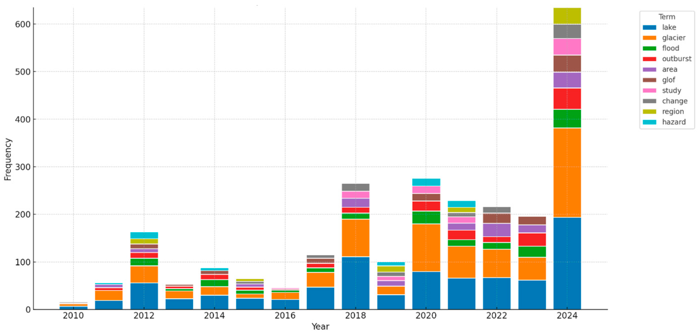
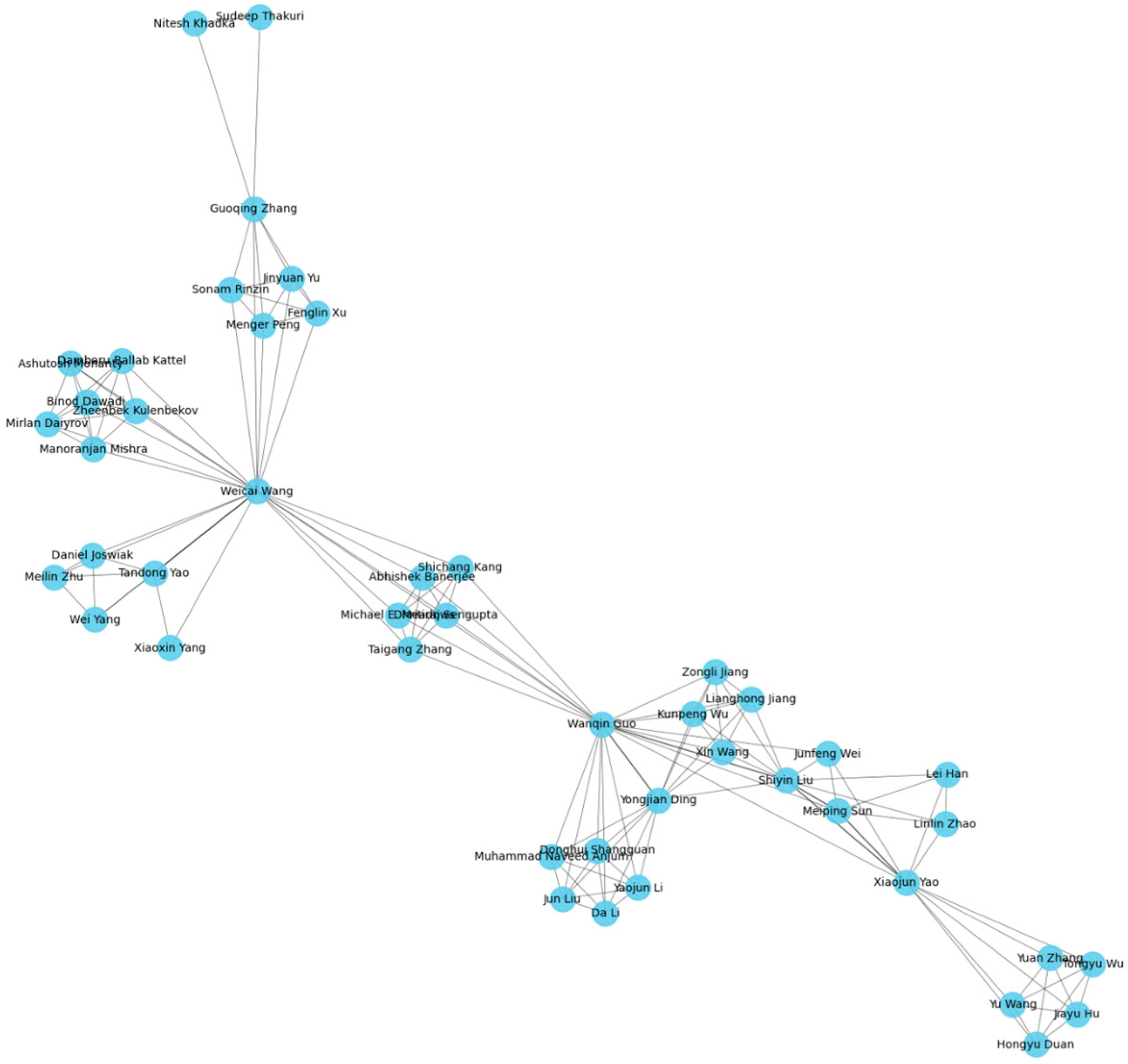
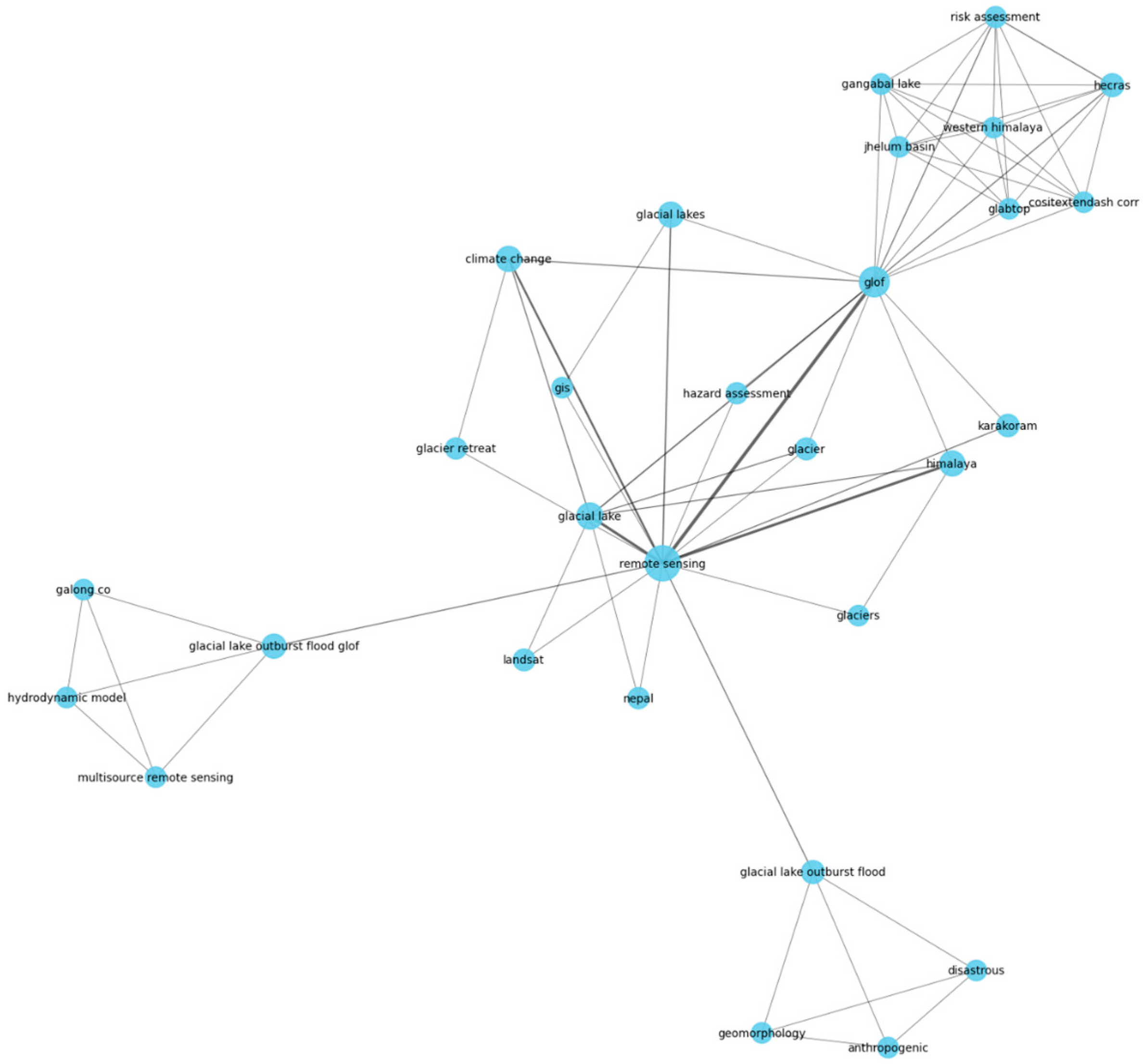
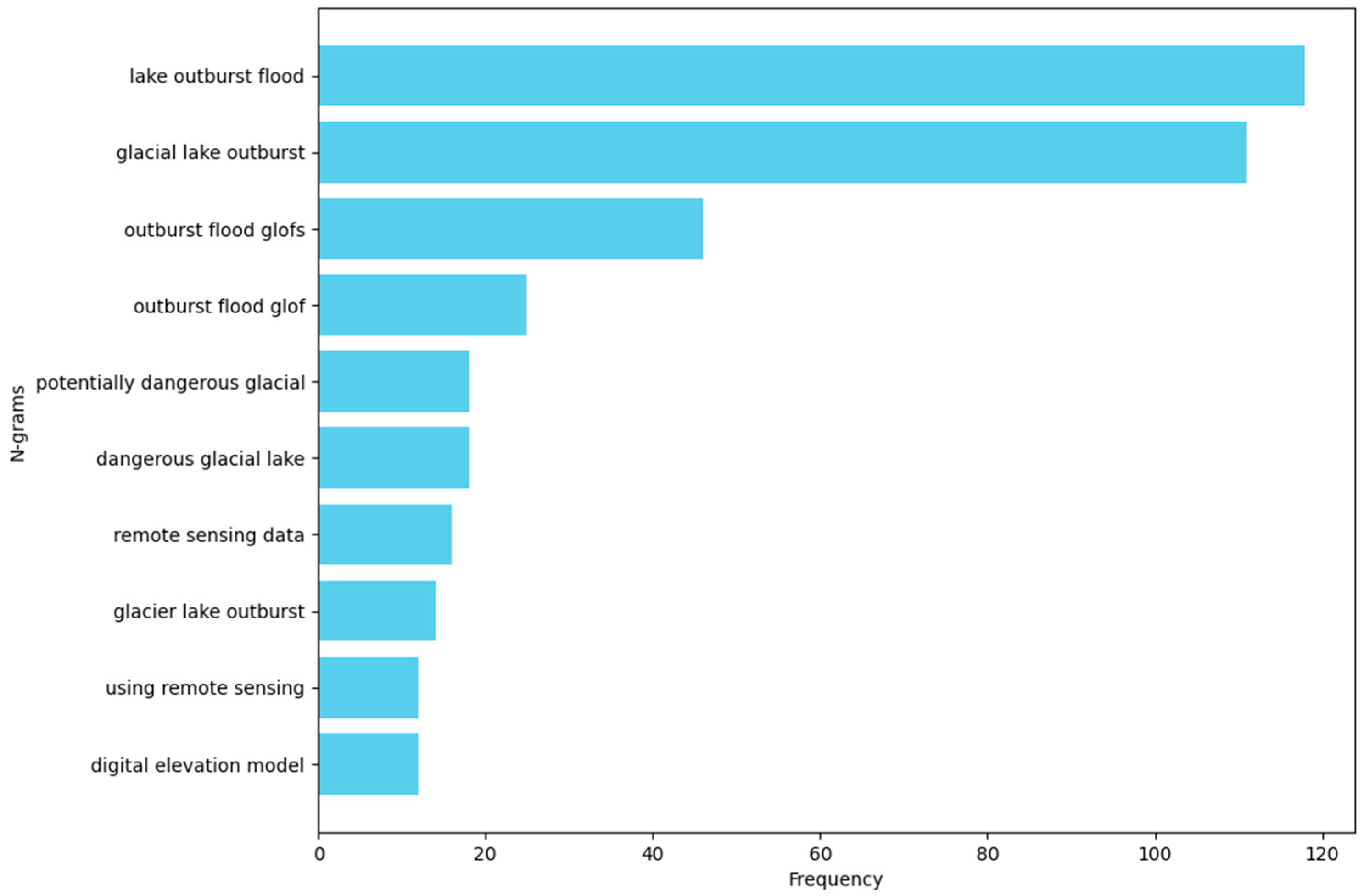
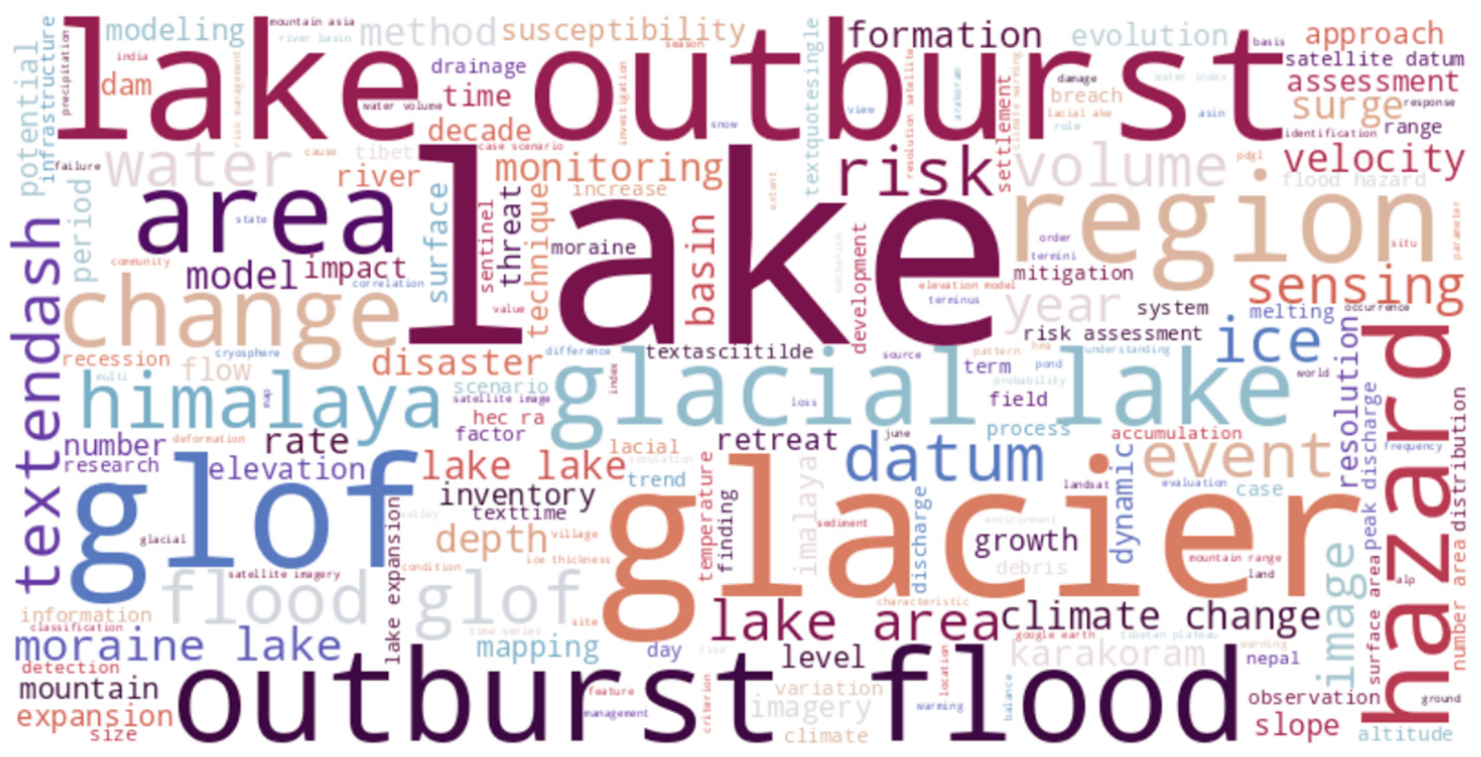
2.3. Bibliometric Analysis

To complement the systematic literature review, a bibliometric analysis of 92 studies was conducted to identify key themes, map the intellectual structure of the field, and visualize the geographical distribution of research on GLOFs and remote sensing. The bibliometric analysis was carried out using a combination of tools and software to ensure a comprehensive and multi-dimensional evaluation. An open-source Geographic Information System (GIS) software, QGIS (version Desktop 3.28.2), was employed to prepare maps highlighting the geographical distribution of study areas, giving a clear view of where GLOF-related research has been focused. This spatial analysis helps identify regions that have received significant attention and those that remain understudied, offering insights into potential gaps in the literature. For the analysis of literature metrics, Python Version 3.10 was utilized, leveraging libraries such as nltk, wordcloud, bibtexparser, pandas, tabulate, and matplotlib. These libraries enabled the extraction, processing, and visualization of key bibliometric data, including publication trends, citation patterns, keyword co-occurrence, and collaboration networks. The nltk library was used for natural language processing tasks, such as keyword extraction and text analysis, while wordcloud facilitated the visualization of frequently occurring terms and themes. The bibtexparser library was employed to parse bibliographic data, and pandas was used for data manipulation and analysis. Finally, matplotlib and tabulate were utilized to generate visualizations and tables summarizing the findings. By combining spatial analysis with advanced bibliometric techniques, this approach offers a holistic understanding of the field’s evolution, intellectual structure, and geographical focus, while also identifying areas for future research and collaboration.
The geographical distribution of study areas (Figure 2) provides critical insights into the regions where research on GLOFs and remote sensing has been concentrated. We employed natural Jenks symbology and classified it into five groups: 0, 0–2, 2–13, 13–26, 26–32. Based on the analysis of the studies included in this review, the research landscape is heavily skewed toward specific high-mountain regions, particularly in Asia, which has emerged as the focal point for GLOF-related studies. The highest concentration of research is observed in the Hindu Kush, Karakoram, and Himalayan regions, with significant contributions from countries such as India, China, Nepal, and Pakistan. These regions are particularly vulnerable to GLOFs due to their extensive glacial coverage, rapid glacier retreat under climate change, and high population density in downstream areas. Central Asian countries, including Kazakhstan, Kyrgyzstan, and Tajikistan, have also been the focus of research, though to a lesser extent compared to the Himalayas. Bhutan, despite its small size, has been a notable focus due to its high vulnerability to GLOFs. In Europe, research has primarily centered on the Alpine region, with studies conducted in Switzerland, Austria, France, and Norway. In the Americas, research has been limited, with a few studies focusing on Canada, the United States, and Peru, the latter highlighting the risks posed by glacial lakes in the Andes. This geographical distribution highlights a clear concentration of research in High Mountain Asia (HMA), particularly in the Himalayas and surrounding regions, which are among the most vulnerable to GLOFs.
For this review, publications from 2010 to 2025 were selected, a period characterized by significant advancements in remote sensing technology and an intensified emphasis on climate-related phenomena. This period coincides with the rapid evolution of remote sensing applications for GLOF monitoring and mapping, driven by improvements in sensor accuracy, data processing capabilities, and the availability of high-resolution satellite imagery. A bar graph (Figure 3) depicting the annual number of publications reveals a clear upward trend, reflecting the increasing research activity in this field. This growth highlights the expanding reliance on remote sensing technologies for effective risk assessment and a deeper understanding of glacial lake dynamics under changing climatic conditions. To further analyze the evolution of the research focus, the frequency of key terms used in publications over the years was examined using Python for data extraction, processing, and visualization. The results, summarized in Figure 4, demonstrate notable trends and shifts in research priorities. Terms such as “lake”, “glacier”, and “flood” consistently dominate the literature, underscoring the central focus on glacial lakes and their outburst mechanisms. Over time, the increasing prominence of terms like “remote”, “sensing”, and “data” reflects the growing reliance on technological advancements and data-driven methodologies in GLOF research. These trends not only illustrate the evolution of research priorities but also emphasize the critical role of remote sensing in advancing our understanding of GLOFs and mitigating their risks.
Alongside highlighting the evolution of the literature, the co-authorship network (Figure 5) provides valuable insight into the collaborative landscape of GLOF research. The co-authorship network, visualized in the largest connected component, highlights the collaborative relationships among researchers in the field of GLOFs and remote sensing. The network reveals a dense web of connections, indicating strong collaboration patterns among key authors. Each node in the network represents an individual author, and edges between nodes indicate co-authored publications—where thicker edges signify stronger collaboration. This visualization underscores the interdisciplinary nature of GLOF research, where expertise in remote sensing, glaciology, and risk assessment converges. The presence of well-connected authors and collaborative clusters highlights the importance of teamwork in addressing the complex challenges posed by GLOFs, particularly in the context of climate change.
The keyword co-occurrence network (Figure 6) provides a visual representation of the most frequently occurring and interconnected terms in the literature on GLOFs and remote sensing. Central to the network are terms such as “glacial lakes”, “climate change”, and “glacial retreat”, which highlight the primary focus of research on the formation and dynamics of glacial lakes in the context of global warming. The strong connections between these terms and “hazard assessment” and “risk assessment” underscore the emphasis on evaluating the risks posed by GLOFs to downstream communities and infrastructure. The network also reveals the integration of advanced methodologies, as evidenced by terms like “multisource remote sensing” and “hydrodynamic model”, which reflect the growing reliance on diverse remote sensing technologies and modeling approaches to study GLOFs. Additionally, terms such as “geomorphology” and “glacial lake outburst flood” indicate a focus on understanding the physical processes and geomorphic impacts of these events. This visualization not only maps the key themes in GLOF research but also highlights the interdisciplinary nature of the field, where climate science, remote sensing, hydrology, and risk management converge. The interconnectedness of these terms illustrates the comprehensive approach required to address the complex challenges posed by GLOFs in a rapidly changing climate.
In addition to co-authorship analysis, we further analyzed the textual data from the “Title, Abstract, and Keyword” from the literature using N-grams (Figure 7) and word cloud (Figure 8) visualizations to get additional insights into the most frequently occurring phrases and terms in GLOF research. These tools are particularly valuable in bibliometric studies because they distill large textual datasets into interpretable visual or quantitative outputs, allowing us to gauge prevalent research topics and shifts in thematic focus. N-grams, generated using the Natural Language Toolkit (NLTK) in Python (Version 3.13.0), reveal the most common multi-word sequences, such as “glacial lake outburst flood”, “remote sensing data”, and “digital elevation model.” These phrases highlight the central themes of the research, emphasizing the focus on GLOF dynamics, the use of remote sensing technologies, and the application of elevation models for hazard assessment. The word cloud, created using the WordCloud library in Python, visually represents the frequency of individual terms, with larger words indicating higher occurrence. Prominent terms like “lake”, “glacial”, “outburst”, and “flood” dominate the visualization, reinforcing the primary focus of the literature. The presence of terms like “remote sensing”, “climate change”, “hazard”, and “risk assessment” further underscores the integration of advanced technologies and the emphasis on understanding GLOFs in the context of global warming. These analyses are crucial in bibliometric studies as they provide a quantitative and visual summary of the key themes and trends in the literature. The N-grams and word cloud not only validate the findings from the keyword co-occurrence network but also offer a more granular understanding of the research priorities. While the word cloud identifies highly frequent individual concepts, N-grams reveal the critical contextual relationships between these concepts, illustrating the evolving methodological and thematic frameworks. Together, they illustrate the interdisciplinary nature of GLOF studies, where remote sensing, climate science, and risk management converge to address the challenges posed by these hazardous events. Thus, future glacial-lake research is likely to delve deeper into the interplay of these advanced technologies for proactive hazard mitigation and adaptation strategies.
This review employs a narrative synthesis methodology, systematically organizing and integrating findings according to the specific remote sensing technologies utilized and their application in understanding GLOF dynamics and monitoring. This approach facilitates a detailed discussion on the efficacy of various remote sensing tools and the technological advancements within GLOF research. By adopting this structured framework, this review seeks to provide a comprehensive overview of how remote sensing has been implemented to enhance our understanding and monitoring of GLOFs. It focuses on summarizing technological advancements, evaluating the effectiveness of diverse remote sensing techniques, and identifying key areas for future research within this critical domain of hazard assessment.

3. Role of Remote Sensing in GLOF Studies

GLOFs represent a critical natural hazard that has drawn increasing scholarly attention over recent decades. The integration of remote sensing into glaciological research has evolved from early aerial photography to sophisticated multi-sensor data fusion techniques, fundamentally transforming the way researchers monitor glacier dynamics and assess flood hazards [38]. This section provides a comprehensive review of the role of remote sensing in GLOF studies by discussing its historical evolution, current technological advancements, and data analysis methodologies used to quantify and predict glacial lake dynamics.

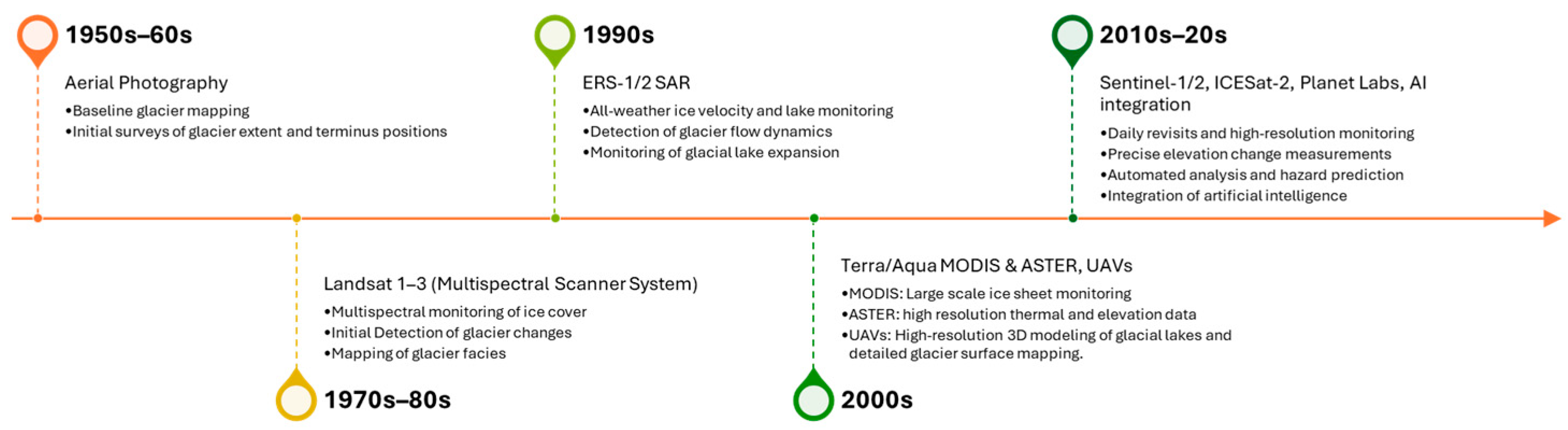
3.1. Historical Overview: The Evolution of Remote Sensing in Glaciology

Remote sensing techniques have long been recognized as indispensable tools in the field of glaciology. The evolution of these techniques (Figure 9) over the decades has significantly enhanced our ability to monitor glaciers and glacial lakes, providing critical insights into their dynamics and the associated hazards, such as GLOFs [39,40].
In the early stages of glacial research, aerial photography was the primary means of capturing images of remote glacierized areas [41]. These early studies, conducted in the 1950s and 1960s, provided the first systematic documentation of glacier extents and the formation of glacial lakes behind terminal moraines. Aerial surveys were particularly useful for creating baseline maps of glacier coverage and identifying the formation of glacial lakes behind terminal moraines [42,43]. Despite the labor-intensive nature of manual image interpretation and field validation, these pioneering efforts laid the groundwork for the systematic study of glacial processes and GLOF hazards.
The advent of satellite remote sensing in the 1970s marked a significant milestone. The launch of the Landsat program, particularly Landsat 1–3 with their Multispectral Scanner System (MSS), introduced the capability to acquire multispectral imagery at moderate spatial resolutions. This enabled researchers to monitor extensive glaciated terrains over time, detect changes in glacier facies, and map glacier extents more efficiently [37,44]. Landsat Thematic Mapper (TM) sensor, with a spatial resolution of 30 m, was particularly instrumental in identifying and mapping glacial lakes and assessing changes in glacier extents over large areas [45]. Early applications predominantly relied on optical data; however, these methods were hampered by issues such as cloud cover and seasonal snow, which limited temporal consistency in the data [46].
Despite these challenges, early satellite-based studies established the potential of remote sensing for detecting changes in glacier morphology and glacial lake dynamics. The initial inventories derived from Landsat imagery not only provided spatially extensive data but also introduced quantitative methods for assessing glacial retreat and lake expansion [46,47]. These pioneering studies highlighted that even modest changes in glacier mass balance could have significant implications for downstream flood hazards, thereby emphasizing the need for continuous monitoring and advanced analytical techniques [48].
Throughout the 1990s, advancements in Synthetic Aperture Radar (SAR) technology, particularly through satellites like ERS-1/2, complemented optical remote sensing. SAR allowed for all-weather, day-and-night capabilities, thus revolutionizing glacial monitoring under frequently cloudy or snowy conditions [49]. This technology enabled the detection of glacier flow dynamics, measurement of ice velocities, and effective monitoring of the expansion of glacial lakes, providing new insights into glacier stability and lake-induced hazards under any weather conditions [50,51]. These advancements in technology helped in highlighting the importance of monitoring lake expansion rates and the potential for cascading GLOF events, which could have devastating impacts on downstream communities and infrastructure [52]. Moreover, the ability to monitor these lakes year-round, regardless of weather conditions, was a significant advancement in GLOF hazard assessment [53]. However, early SAR data had coarser resolution compared to contemporary optical sensors and could be complex to process.
The 2000s brought further advancements with the launch of Terra/Aqua MODIS and ASTER sensors. MODIS provided large-scale ice sheet monitoring, while ASTER offered high-resolution thermal and elevation data, enabling more precise mapping of glacier surfaces and glacial lakes [47,54]. Additionally, the use of unmanned aerial vehicles (UAVs) became more prevalent, allowing for high-resolution 3D modeling of glacial lakes and detailed glacier surface mapping [55]. However, their utilization could be limited by battery life, payload capacity, flight regulations, and reliance on clear weather.
In the 2010s and 2020s, the integration of advanced sensing technologies and artificial intelligence marked a new era in glaciology. Sentinel-1/2, ICESat-2, and Planet Labs, equipped with capabilities for daily revisits and high-resolution monitoring, significantly improved the frequency and detail of observations [56,57]. Precise elevation change measurements from ICESat-2 and automated analysis through AI integration transformed data processing, enhancing the predictive capabilities for identifying potential GLOF events [58,59]. These advancements not only facilitated continuous and precise monitoring but also enabled timely warnings and effective mitigation strategies.
The historical evolution of remote sensing in glaciology has been marked by significant advancements in technology and methodology. From the early days of aerial photography to the current use of high-resolution satellite imagery and AI, remote sensing has provided invaluable insights into glacier retreat, glacial lake formation, and GLOF hazards. The integration of multiple data sources and methodologies has enabled researchers to develop more accurate and comprehensive assessments of GLOF susceptibility, particularly in understudied regions like the Canadian Cordillera and the Himalayas. As climate change continues to drive glacier retreat and lake expansion, the role of remote sensing in monitoring and mitigating GLOF risks will remain critical.

3.2. Current Technologies in GLOF Monitoring

In recent years, remote sensing technologies have undergone rapid advancements, providing a suite of tools that greatly enhance the monitoring and analysis of glacial lake dynamics and GLOF hazards. These technologies, ranging from optical and radar satellites to unmanned aerial vehicles (UAVs), have revolutionized our ability to assess glacier retreat, lake expansion, and the stability of glacial lake dams.

3.2.1. Satellite Imagery: Overview of Satellite Technologies Used in GLOF Monitoring

To understand the complex dynamics of glacial lakes and assessing the risks of outburst floods, satellites carrying both optical and radar sensors (Table 1) are essential. Their ability to provide detailed, consistent data regardless of weather conditions allows for comprehensive monitoring of lake changes, glacier movement, and surrounding terrain, all crucial for effective GLOF hazard assessment.
Contemporary optical sensors, such as those on Landsat 8 and Sentinel-2, offer moderate to high spatial and spectral resolution data that are critical for mapping glacial features [60,61]. Landsat 8, with its 30-m multispectral bands and 15-m panchromatic band, allows for detailed delineation of glacier and lake boundaries. Similarly, Sentinel-2, with a resolution of 10 m in several spectral bands, facilitates the detection of subtle changes in water bodies and land cover. These platforms enable time series analysis of glacial lakes, making it possible to quantify annual changes in lake area and volume. For instance, multi-temporal analyses have been used to document the rapid expansion of glacial lakes in High Mountain Asia, where increasing lake size often correlates with heightened GLOF risk [62]. Furthermore, high-resolution optical satellites like WorldView (0.3 m panchromatic) and Pleiades (0.5 m panchromatic) deliver detailed imagery to monitor small-scale morphological changes in lake boundaries and dam structures, particularly in rugged terrains [14,28]. Gaofen-1 (2 m panchromatic) and SPOT-6 (1.5 m resolution) further enhance this capability by combining wide coverage with rapid revisit times, making them ideal for large-scale glacial lake inventories [3,63]. Sensors such as LISS (IRS series) and RapidEye (5 m panchromatic) support historical trend analysis, while SuperDove (3 m panchromatic) and Planet (3–5 m resolution) enable daily global monitoring to detect abrupt changes during monsoon seasons [46,61,64]. Thermal bands on Landsat-8 also support identifying ice-melt patterns and thermal anomalies near glacial lakes [65].
However, optical systems face significant challenges that limit their effectiveness in glacial environments. Cloud cover frequently obstructs optical imagery in mountainous regions, leading to data gaps during critical monitoring periods [53]. Additionally, optical sensors are dependent on daylight, rendering them ineffective at night. They also cannot penetrate ice, snow, or vegetation to detect subsurface changes or subtle ground deformation, which are critical for assessing GLOF risks [66]. Furthermore, spectral misclassification in shadowed or turbid water areas may lead to errors in lake boundary extraction [67]. These limitations highlight the need for complementary technologies, such as radar and InSAR systems, which overcome environmental constraints and provide critical subsurface and deformation data.
Radar systems address the shortcomings of optical sensors by offering all-weather, day-and-night imaging capabilities, making them indispensable in cloud-prone glacial environments. Synthetic Aperture Radar (SAR) satellites, such as Sentinel-1 (C-band, 5–20 m resolution) and RISAT (C-band, 1–50 m resolution), utilize interferometric techniques (InSAR) to measure millimeter-scale ground deformation, glacier velocities, and dam stability [49,51,68]. For example, Sentinel-1’s repeat-pass InSAR detects subsidence or bulging in moraine dams, providing early warnings of potential failure [69]. High-resolution radar platforms like TerraSAR-X (X-band, 1–40 m resolution) and COSMO-SkyMed (X-band, 1–40 m resolution) map ice flow dynamics and crevasses with unparalleled detail, even in darkness or storm conditions [70,71]. L-band SAR sensors, such as ALOS-PALSAR (10–100 m resolution), penetrate vegetation and snow cover to monitor subsurface glacier movement and buried ice in moraines, which is critical for assessing hidden GLOF triggers [72]. RADARSAT-2 (C-band, 3–100 m resolution) supports flexible imaging modes for regional-scale glacier dynamics, while historical missions like Envisat (30–150 m resolution) and ERS-1/2 provide long-term datasets to analyze glacier retreat trends [73,74].
The integration of radar and optical data further enhances GLOF monitoring. For instance, combining Sentinel-1 (radar) with Sentinel-2 (optical) improves the detection of lake area changes and dam deformation, while multi-sensor fusion with LiDAR and gravity data (e.g., GRACE) enables comprehensive assessments of glacial mass balance and lake volume changes [57,75,76]. Together, these technologies provide a robust framework for real-time monitoring, historical trend analysis, and predictive modelling of GLOF risks, empowering stakeholders to implement timely mitigation strategies in vulnerable regions.

3.2.2. Unmanned Aerial Vehicles (UAVs) and Aerial Photography

In addition to satellite-based remote sensing, UAVs and high-resolution aerial photography have emerged as critical tools for localized glaciological studies. UAVs are capable of capturing imagery with resolutions of less than one meter, which is invaluable for validating satellite-derived measurements and for detailed studies of dam morphology and topographic changes [77,78]. UAV-based surveys are particularly useful in areas where high-resolution satellite imagery is unavailable or when rapid, localized assessments are required following a GLOF event [55,79]. For instance, UAVs can quickly deploy to capture post-event imagery, enabling rapid damage assessment and identifying newly formed ice-dammed lakes [80].
Aerial photography has played a fundamental role in glaciology since its inception. Historically, it provided the first means to systematically document glacier extents and the formation of glacial lakes, setting the stage for modern remote sensing techniques [41]. Today, integrating historical aerial photographs with contemporary UAV imagery offers a time-extended view of glacial changes, aiding in the study of long-term glacier retreat and lake evolution [43].
The integration of UAV imagery with satellite data further refines the accuracy of mapping and modelling efforts. UAV-derived DEMs capture fine-scale topographic variations around glacial lakes, such as cracks in moraine dams or subtle changes in glacier termini, which are often missed by coarser satellite data [80]. These high-resolution DEMs enhance the precision of lake volume estimations and flood modelling efforts, providing critical inputs for GLOF risk assessments [81]. Furthermore, UAVs can be deployed quickly and provide data in real-time, which is vital for emergency response and disaster readiness in the event of a GLOF. The agility of UAVs makes them an invaluable asset in dynamic and rapidly changing environments typical of glacial landscapes.
In summary, the application of UAVs and aerial photography in glacial studies not only supports traditional remote sensing data but also extends the capabilities of glacial monitoring systems. These tools enable more detailed and frequent observations that are crucial for the effective management and mitigation of risks associated with glacial lake outbursts.

3.2.3. Multi-Sensor Data Fusion

In the realm of glacial monitoring, the integration of data from various remote sensing technologies marks a significant evolution, enhancing the depth and accuracy of environmental analysis. Multi-sensor data fusion stands out as one of the most notable advancements in recent remote sensing research, particularly for its application in glaciology [82]. This approach synergizes the strengths of diverse sensing technologies, including optical, radar (SAR), and digital elevation models (DEMs), to forge a comprehensive understanding of glacial dynamics and GLOF risks [57].
The core of multi-sensor data fusion involves blending the high spatial resolution and spectral capabilities of optical sensors with the all-weather, day-and-night imaging capabilities of SAR systems, supplemented by the topographic and volumetric data provided by DEMs [75,83]. The fusion of these data types enables the development of sophisticated models that can accurately estimate glacial lake parameters and assess dam stability. For example, combining Sentinel-2 (optical) with Sentinel-1 (radar) allows for the simultaneous detection of surface water changes and subtle dam movements, providing early warnings of potential GLOF triggers [84]. Integrating ICESat-2 (LiDAR) with ALOS World 3D (SAR) refines volume estimations and flood modelling by capturing both surface and subsurface changes, while UAV-derived DEMs enhance the precision of satellite-based topographic models, enabling detailed assessments of moraine dam stability and glacier retreat patterns [85]. A typical workflow for multi-sensor data fusion involves data acquisition from optical, radar, LiDAR, and UAV platforms, followed by pre-processing to correct atmospheric effects, geometric distortions, and radiometric calibration [64,86]. Advanced algorithms are then used to extract key parameters such as lake boundaries, glacier velocities, and ground deformation, which are integrated using machine learning or statistical models to create a unified representation of glacial lake dynamics. This integrated approach supports the development of predictive models for GLOF risk assessment, improving accuracy and reliability by incorporating inputs from multiple sensors.
The practical implementation of multi-sensor data fusion involves several steps, beginning with the collection and preprocessing of data from various sources. Figure 10 outlines the steps in multi-sensor data fusion—from data acquisition through pre-processing to parameter extraction and model integration. The data are then aligned and integrated using algorithms that handle the different resolutions and data types to produce a cohesive dataset. Advanced analytical techniques, such as interferometric synthetic aperture radar (InSAR), are then applied to this integrated dataset. InSAR is particularly useful for detecting subtle deformations in the glacier surface or the moraine dams that might not be visible with optical images alone.
In conclusion, multi-sensor data fusion represents a transformative approach to glacial lake monitoring, enabling comprehensive assessments of GLOF hazards by leveraging the complementary strengths of optical, radar, LiDAR, and UAV technologies. This integrated framework not only improves the accuracy of risk assessments but also supports the development of early warning systems and mitigation strategies for vulnerable communities.

3.3. Data Analysis Methods

The effective application of remote sensing in GLOF studies depends on the availability of advanced sensors and the development of robust data analysis methodologies. These methods span change detection, physical parameter estimation, and glacier dynamics monitoring, each contributing uniquely to understanding glacial lake evolution and GLOF hazards. The following subsections detail key techniques employed in analyzing remote sensing data for monitoring glacial lakes and assessing GLOF hazards.

3.3.1. Change Detection

Change detection is a foundational analytical technique for monitoring temporal variations in glacial lakes and their associated glaciers, playing a vital role in GLOF risk assessment [87,88]. It is a cornerstone of glacial lake monitoring, enabling researchers to quantify temporal variations in lake area, ice/snowmelt, and glacier dynamics. The ability to identify and quantify changes in lake area, ice extent, and terrain stability is critical for assessing GLOF risks, particularly in remote and inaccessible alpine regions [46]. These analyses are critical for identifying emerging GLOF risks, such as rapid lake expansion or moraine dam instability. Over time, methodologies have evolved from the manual interpretation of multi-temporal images to advanced automated workflows that can integrate multi-sensor data and advanced techniques [2]. Several methods are employed in GLOF studies, each with its strengths and limitations. Table 2 provides a comprehensive overview of key change detection techniques, detailing their specific applications in GLOF research and analyzing their strengths and weaknesses.
Spectral index differencing, such as the Normalized Difference Water Index (NDWI) and Modified NDWI (MNDWI), remains a widely adopted method for delineating lake boundaries and tracking surface area changes [72]. NDWI, calculated using green and near-infrared bands, is effective for mapping clear-water lakes but struggles in turbid or shadowed conditions. MNDWI, which substitutes shortwave infrared (SWIR) for near-infrared, improves performance in debris-rich environments. Despite their simplicity, these indices are sensitive to atmospheric interference and cloud cover, limiting their utility in monsoon-prone regions [37]. Building on spectral indices, image differencing, another optical technique, identifies abrupt changes such as ice collapse or lake expansion by subtracting pixel values between two dates [89]. While straightforward, this method requires precise radiometric calibration and co-registration to avoid false positives caused by seasonal illumination variations.
Building upon the concept of differencing but offering greater dimensionality, Change Vector Analysis (CVA) extends traditional differencing by analyzing both the magnitude and direction of spectral changes in multi-dimensional space [2]. This approach is particularly useful for mapping gradual transitions, such as ice-to-water conversion or progressive glacier thinning. However, CVA demands rigorous atmospheric correction and is sensitive to misregistration errors. Similarly, Principal Component Analysis (PCA) reduces the dimensionality of multi-temporal datasets, emphasizing dominant change patterns like glacier retreat or lake growth. While effective for noise reduction, interpreting principal components requires domain expertise, as they often represent composite environmental changes [90]. Post-classification comparison, which involves classifying images from different epochs and quantifying land-cover transitions, provides intuitive results but risks propagating classification errors into change maps [91,92].
Addressing the inherent limitations of optical methods, particularly concerning weather and daylight dependency, SAR coherence change detection addresses the limitations of optical methods by operating independently of weather and daylight. By analyzing phase differences in SAR data, this technique detects surface changes such as water encroachment or dam subsidence [39]. However, temporal decorrelation caused by snowmelt or vegetation growth can degrade coherence, complicating interpretation [93]. Moving from pixel-based to object-oriented analysis, Object-Based Image Analysis (OBIA) segments images into homogeneous objects (e.g., lake patches, moraine dams) using spectral, spatial, and contextual features [94]. This approach reduces salt-and-pepper noise, which is common in pixel-based methods, and enhances dam morphology mapping. Nevertheless, OBIA requires careful parameter tuning and high-resolution data, making it computationally intensive.
Shifting focus to elevation metrics, Digital Elevation Model (DEM) differencing quantifies glacier thinning and lake volume changes by comparing multi-temporal elevation data [95]. LiDAR and UAV-derived DEMs offer sub-meter accuracy, while satellite-based DEMs (e.g., ASTER, TanDEM-X) provide broader coverage. This technique is indispensable for estimating potential flood volumes but requires precise co-registration to minimize errors. Thermal infrared (TIR) change detection identifies temperature anomalies linked to ice melt or subglacial water activity. For instance, Landsat-8’s thermal bands have been used to detect warming trends near glacier termini, signaling increased meltwater input to lakes [96]. However, TIR’s coarse spatial resolution (~100 m) limits its application in small-scale glacial basins.
To handle the complexity and volume of these diverse datasets, advances in machine learning have improved the accuracy of change detection. These methods are proficient in handling the complex spectral variability inherent in alpine environments, where factors such as cloud cover, shadows, and mixed pixels can complicate analysis. Automated change detection techniques not only expedite the mapping process but also enable the identification of abrupt changes in lake area that may signal a potential outburst event.

3.3.2. Estimation of Physical Parameters

In the field of remote sensing applied to GLOF risk assessment, the estimation of physical parameters of glacial lakes and their surrounding environments is a critical component [61,97]. These parameters, which include glacier extent, lake volume, ice thickness, and topographic characteristics, provide the foundational data needed to assess hazard potential, model flood scenarios, and design mitigation strategies [64,98,99]. Remote sensing technologies have revolutionized the ability to measure these parameters over large and often inaccessible regions, offering high-resolution, multi-temporal datasets that were previously unattainable through ground-based methods alone [87,100,101]. However, the accuracy of these measurements varies depending on sensor capabilities, environmental conditions, and data processing techniques (Table 3). For instance, glacier extent mapping using optical imagery achieves high accuracy (>90%) under clear-sky conditions but suffers from errors (~20–30%) in debris-covered or shadowed areas [102,103]. Similarly, lake volume estimates derived from DEM differencing exhibit great uncertainties due to co-registration errors and terrain complexity [104], while LiDAR and UAV photogrammetry reduce these errors in localized studies [78,81]. Despite these variability-driven challenges, advancements in multi-sensor integration and error-correction algorithms enable researchers to derive robust estimates of critical parameters. This accurate knowledge of these parameters not only deepens our understanding of the physical processes leading to GLOFs but also enhances our ability to predict and mitigate these potentially catastrophic events, enabling more reliable risk assessments and early warning systems.
Table 3 highlights various physical parameters that can be quantified using remote sensing technologies, detailing their measurement techniques, the specific remote sensing tools utilized, and their relevance in GLOF studies. The estimation of lake area and volume is foundational in assessing the potential impact of GLOF events [6,25]. Satellite optical imagery, particularly from Landsat and Sentinel-2, is typically used to delineate lake boundaries [32,98]. These measurements are critical for applying empirical relationships that estimate lake volume based on observed surface area [102,103]. Further refinement is achieved through the integration of Digital Elevation Models (DEMs), which provide a three-dimensional perspective of the lake basin and aid in more precise volume calculations [104]. This data is essential for modelling how lakes might respond under different flood scenarios and for understanding the dynamics of water release during GLOF events.
Quantifying glacier thinning and volume loss is essential for understanding mass balance and predicting future lake formation [27]. Digital Elevation Model (DEM) differencing, which compares multi-temporal elevation datasets, is the primary method for measuring surface elevation changes [25]. Satellite-derived DEMs, such as ASTER (30 m) and TanDEM-X (12 m), offer broad coverage, while airborne LiDAR and UAV photogrammetry provide sub-meter vertical accuracy for localized studies [104,105]. ICESat-2’s laser altimetry, for instance, measures ice sheet elevation changes with millimeter precision, offering critical insights into glacier health. However, DEM accuracy varies with terrain complexity, and co-registration errors can inflate uncertainty in volume calculations [6,9]. In short, DEM differencing delivers unrivalled quantitative insight into glacier mass balance, yet its reliability is contingent on meticulous co-registration and terrain-specific error modelling.
The delineation of glacial lake boundaries and estimation of lake volume are central to GLOF risk assessment. Spectral indices like NDWI and Modified NDWI (MNDWI) are widely used to map lake boundaries in optical imagery [54,106]. UAV-derived bathymetry and LiDAR improve volume estimates by incorporating depth measurements and reducing reliance on area-based approximations [107]. Monitoring lake water levels and ice/snow cover provides insights into seasonal variability and potential triggers for GLOFs [108]. Radar altimetry (e.g., Sentinel-3, ICESat-2) tracks water level fluctuations with centimeter-scale precision, detecting rapid changes indicative of instability [58]. Optical sensors like MODIS and Sentinel-2 monitor ice and snow cover using indices such as NDSI, which identify meltwater sources [30,106]. However, atmospheric interference and debris cover can degrade accuracy, necessitating complementary thermal or SAR data for validation. Thus, fusing optical, radar, and UAV observations yields robust lake-volume and stability metrics, although persistent atmospheric noise and surface debris continue to challenge classification accuracy.
Surface temperature, measured using thermal infrared (TIR) bands on Landsat-8 and MODIS, helps identify melt hotspots and subglacial water pathways [96,109]. Water turbidity and sediment load, estimated through spectral analysis of red and near-infrared bands, signal erosion processes that weaken moraine dams [44]. For instance, PlanetScope’s high revisit frequency enables near-real-time monitoring of sediment plumes in HMA lakes, though accuracy depends on water clarity and sun-glint effects [110]. Collectively, TIR and high-revisit optical sensors allow near-real-time tracking of thermal and sediment anomalies, yet their performance is moderated by water clarity and solar-reflection artefacts.
Ice thickness, a critical factor in glacier stability, is measured indirectly using ground-penetrating radar (GPR) or inferred from surface velocity models [107]. Satellite altimetry (e.g., ICESat-2) and SAR penetration (L-band) enhance large-scale assessments, though field validation remains essential [8,111]. Understanding the topography of glaciers and lakes involves measuring changes in surface elevation and overall glacier volume [112]. Techniques such as DEM differencing and Interferometric Synthetic Aperture Radar (InSAR) are crucial in these assessments [24]. Data from platforms like the Shuttle Radar Topography Mission (SRTM) and TanDEM-X provide detailed elevation information that is vital for tracking glacier retreat and detecting thinning ice areas, which can indicate potential vulnerabilities in glacier dam stability [104]. These methods provide indispensable data for understanding glacier stability and potential dam vulnerabilities, though they often require indirect measurements and field validation.
Each of these parameters benefits significantly from the integration of remote sensing data, which provides a continuous, detailed, and accessible means of monitoring changes in the glacial environment. The capabilities of modern remote sensing technologies to deliver timely data across large, often inaccessible areas make them indispensable tools in the ongoing effort to mitigate the risks associated with GLOFs.

3.3.3. Monitoring Glacier Dynamics

An important aspect of GLOF risk assessment is the continuous monitoring of glacier dynamics, as changes in glacier behavior directly influence the stability of ice- and moraine-dammed lakes. Understanding the temporal evolution of glaciers, particularly their flow, deformation, and mass balance, provides essential insights into the stability of glacier-fed lakes and the potential for dam failure [113]. Glacier dynamics encompass processes such as ice flow velocity, surface deformation, terminus retreat, and mass balance, all of which provide critical insights into the likelihood of dam failure and subsequent flooding [40,114,115]. Remote sensing technologies, including Synthetic Aperture Radar (SAR), optical imagery, and UAV photogrammetry, have emerged as powerful tools for tracking these dynamic processes across vast and inaccessible mountain regions.
The key parameters and monitoring methods for glacier dynamics are summarized in Table 4. Glacier flow velocity, a key indicator of ice dynamics, is measured using Interferometric SAR (InSAR) and optical feature tracking. It is crucial for predicting ice calving events and glacier surges, both of which can destabilize glacial lakes [110]. Surface deformation, including subsidence or bulging of moraine dams, can be monitored using Differential InSAR (DInSAR) and Persistent Scatterer InSAR (PSInSAR), as well as high-resolution UAV photogrammetry [64]. These techniques quantify vertical and horizontal displacements with sub-centimeter precision, identifying areas of stress accumulation.
Time series analyses using satellite imagery have also proven invaluable. By constructing multi-temporal datasets, researchers can track the progression of glacier retreat and correlate these changes with corresponding variations in lake area. Such analyses not only reveal trends in glacier mass loss but also help establish thresholds beyond which the risk of GLOF increases significantly [98,102].
Another important parameter, glacier mass balance, which is the difference between accumulation and ablation, is estimated using DEM differencing and gravimetry. It provides a comprehensive assessment of ice loss or gain [6,66]. DEM differencing compares elevation changes over time, while gravimetry measures changes in the Earth’s gravitational field due to ice mass variations. These measurements are essential for predicting changes in lake volume and understanding the overall health of the glacier.
Crevasse formation, a marker of glacier stress, is mapped using UAV photogrammetry and high-resolution optical imagery (e.g., PlanetScope or WorldView). Sub-meter resolution datasets capture crack density and orientation, identifying zones prone to ice collapse [110]. Subglacial hydrology, mapped using ground-penetrating radar, reveals subglacial drainage systems that may trigger outbursts. Finally, InSAR and optical feature tracking monitor terrain stability, which assesses slope instability and moraine dam movement.
Monitoring glacier dynamics through remote sensing provides a comprehensive understanding of the processes driving GLOF hazards. Techniques like InSAR, optical tracking, and UAV photogrammetry offer high-precision, multi-scale insights into ice flow, deformation, and dam stability. When integrated with hydrodynamic models, these data empower stakeholders to predict outburst scenarios, prioritize mitigation efforts, and implement timely interventions. As climate change accelerates glacier retreat, advancing these monitoring frameworks will be vital for safeguarding vulnerable communities in high-mountain regions.

3.3.4. Advanced Analytical Techniques: Integration of Machine Learning in GLOF Research

The complexities inherent in GLOF research, characterized by dynamic glacial environments and intricate spatial–temporal interactions, necessitate the adoption of advanced analytical techniques. Machine learning (ML) has emerged as a transformative tool in this domain, offering unprecedented capabilities for data processing, pattern recognition, and predictive modelling [4,36]. By leveraging the power of algorithms and computational resources, ML techniques are enhancing our understanding of GLOF mechanisms and improving the accuracy of risk assessments.
Table 5 details the specific applications, strengths, limitations, and data requirements of each machine learning technique employed in GLOF studies. This table serves as a critical resource for understanding how different machine learning approaches are applied to remote sensing data to address various challenges in GLOF risk assessment.
Supervised classification techniques like Random Forest and Support Vector Machines (SVM) are employed extensively in glacier and lake mapping, landslide detection, and land cover classification [4,116]. These models are particularly valued for their ability to handle multi-source inputs and provide high accuracy when trained with adequately labeled data. They rely on a range of data, including optical and SAR imagery, digital elevation models (DEMs), and additional geographical layers, such as slope and aspect, which help in accurately delineating and classifying different surface features relevant to GLOF dynamics. However, their performance hinges on extensive labeled training data, which can be labor-intensive to acquire in remote glacial environments.
Unsupervised clustering methods such as K-means and ISODATA play a crucial role in identifying melt patterns, lake expansion trends, and clusters of terrain deformation without the need for labeled datasets [117]. These techniques analyze multi-temporal satellite data to discover hidden patterns and changes over time, providing insights into the gradual changes that might not be immediately apparent. A key limitation is their sensitivity to initialization parameters, and resulting clusters may lack direct physical interpretability, requiring domain expertise to contextualize outputs.
Deep learning algorithms, including convolutional neural networks (CNNs), U-Net, and transformers, are at the cutting edge of automating complex tasks such as lake and ice segmentation, change detection, and glacier flow modelling [59,118]. These algorithms excel at learning hierarchical features from large datasets, making them exceptionally good at handling spatial-temporal tasks that are common in high-resolution remote sensing data analysis. However, these models are computationally intensive and prone to overfitting without large annotated datasets—a challenge in data-scarce regions.
Time series analysis using models like long short-term memory networks (LSTM), artificial neural network (ANN), or autoregressive integrated moving average (ARIMA) models are employed to predict lake level fluctuations, glacier melt rates, and detect anomalies. These models are adept at capturing temporal dependencies, making them particularly useful for forecasting based on historical data [119]. Their effectiveness diminishes with fragmented or incomplete time series data, underscoring the need for continuous monitoring systems [50].
Object-based image analysis (OBIA) integrated with machine learning combines spectral, spatial, and contextual information to map complex phenomena such as debris-covered ice or moraine dam cracks [120]. This approach helps in reducing noise and improving the precision of feature extraction in cluttered or heterogeneous environments. However, its computational demands and complex parameter tuning limit scalability [121]. Anomaly detection techniques such as autoencoders and isolation forests are crucial for detecting unusual events like sudden lake drainage, abnormal glacier velocities, or seismic activities that could potentially trigger a GLOF. These techniques are designed to identify outliers and anomalies in datasets without needing prior labeling of what constitutes a normal or an anomalous event [122]. Ensemble learning methods like XGBoost and model stacking are used to integrate findings from multiple models, thereby reducing overfitting and enhancing the reliability of predictions [123]. These methods combine the strengths of various models to improve overall prediction accuracy for GLOF risk assessment.
Geospatial machine learning approaches, including graph neural networks, are leveraged to model complex spatial interactions among various elements like lakes, glaciers, and terrain. These models are capable of processing large-scale spatial data and integrating diverse datasets, providing a comprehensive view of the environmental factors influencing GLOF risks [124].
The integration of these techniques offers a holistic framework for GLOF risk assessment. For example, combining supervised classification for lake mapping with LSTM-based forecasts and anomaly detection creates a multi-layered early-warning system

4. Risk Assessment Models for GLOFs

GLOFs pose significant threats to downstream communities, infrastructure, and ecosystems in high-mountain regions. Risk assessment models are critical tools for quantifying these hazards, predicting potential impacts, and guiding mitigation strategies [125]. Modern GLOF risk assessment methodologies have evolved to incorporate detailed physical parameters and glacier dynamics data obtained through remote sensing, enhancing the precision and reliability of hazard evaluations. These models can be categorized into three broad approaches: quantitative (e.g., hydrodynamic simulations), semi-quantitative (e.g., statistical frameworks), and qualitative (e.g., multi-criteria decision systems), each addressing distinct aspects of GLOF risk. Traditional approaches often relied on empirical observations, but contemporary models utilize sophisticated techniques to quantify and predict GLOF hazards [72]. Table 6 provides a comparative analysis of key model types employed in GLOF risk assessment, detailing their specific input parameters, the role of remote sensing data in parameter acquisition, and models’ respective strengths and limitations.
As a quantitative approach, hydrodynamic models, such as HEC-RAS, are designed to simulate water flow dynamics and predict flood propagation pathways [88]. They are widely used to map inundation extents and assess downstream impacts by integrating parameters such as lake volume, channel geometry, topography (derived from DEMs), flow roughness, and upstream discharge [119]. Satellite altimetry and optical imagery provide critical inputs for estimating lake volume, while DEMs and land cover classification (using optical/SAR data) define channel geometry and flow resistance. Though these models offer high accuracy in infrastructure planning, their reliability hinges on DEM precision and field calibration, with reduced efficacy in steep or densely vegetated terrain [57].
Statistical models represent a semi-quantitative approach, prioritizing probabilistic risk assessment by leveraging historical GLOF events, lake area changes, glacier retreat rates, and climate variables (e.g., temperature, precipitation) [126]. These models identify trends and recurrence intervals using time series optical/SAR imagery (e.g., Landsat, Sentinel) and reanalysis climate data. While computationally efficient and valuable for identifying historical patterns, they are inherently limited by their reliance on past events, failing to account for novel triggers like unprecedented rainfall or ice avalanches in a warming climate.
Multi-criteria decision models fall under a qualitative framework, adopting a holistic approach to prioritize risk by synthesizing diverse factors such as lake expansion rates, dam type, proximity to infrastructure, avalanche/snowpack risk, and population density [91,127,128]. Remote sensing supports these models through time series optical/SAR imagery for lake monitoring, DEMs for avalanche-prone slopes, and nighttime lights data for mapping settlements. Although they excel in integrating socio-environmental factors, their subjective criteria weighting and qualitative outputs necessitate expert validation [129].
Contemporary GLOF risk frameworks increasingly combine these models to offset individual limitations. For instance, statistical models identify high-probability lakes while, hydrodynamic models map downstream impacts [125,126]. Integrating remote sensing data into these models improves input accuracy and enhances their predictive capabilities, making them essential tools for addressing the hazards posed by GLOFs [127,130]. This dynamic interplay between advanced modelling techniques and cutting-edge remote sensing technologies underpins modern strategies for disaster risk reduction in vulnerable mountainous areas.

5. Challenges and Limitations

The integration of remote sensing technologies and advanced modelling frameworks has significantly advanced GLOF research. However, several challenges and limitations persist, hindering the accuracy, reliability, and practical implementation of these tools in risk assessment and mitigation.
The accuracy and resolution of remote sensing data play a crucial role in the reliability of GLOF risk assessments [62,130]. High-resolution data, such as those from high-resolution commercial satellites or UAVs, can provide detailed information on lake morphology and dam conditions. However, these data sources may be limited in terms of temporal coverage or spatial extent, making it challenging to monitor changes over time or across large regions. On the other hand, moderate-resolution data from satellites like Landsat or Sentinel may offer broader coverage and longer temporal records but may lack the level of detail needed for detailed assessments [131]. Additionally, atmospheric conditions, such as cloud cover or haze, can affect the quality. Moreover, integrating data from multiple sources and sensors involves significant challenges in terms of data compatibility, calibration, and processing [132]. This integration is critical for creating accurate models, but can be technically complex and resource-intensive for optical remote sensing data, limiting their effectiveness in certain regions or time periods.
Predicting GLOF events and their impacts is subject to various uncertainties, including uncertainties in model parameters, input data, and model structure. For example, hydrodynamic models used to simulate flood propagation may be sensitive to uncertainties in lake bathymetry, channel roughness, or precipitation patterns [37,88]. Statistical models, while useful for probabilistic risk assessment, fail to account for novel triggers such as unprecedented rainfall or cascading hazards (e.g., ice avalanches triggered by seismic activity), limiting their predictive power in a warming climate [126]. Furthermore, machine learning frameworks face challenges in generalizing across regions due to data scarcity and variability in glacier dynamics, often overfitting to localized conditions [124]. These uncertainties can lead to discrepancies between model predictions and observed events, highlighting the need for careful validation and calibration of models.
The impacts of climate change are altering glacier behaviors and lake formations at unpredictable rates, which complicates the ability to use past data to predict future events [133]. This rapid environmental change challenges the ability of current models to forecast GLOFs accurately. The geological settings of glacial lakes vary widely, and the hydrological processes involved in lake formation and drainage are complex and not fully understood [134]. These uncertainties make it difficult to generalize findings from one region to another or to extrapolate results from small-scale studies to larger regions.
The implementation of advanced remote sensing technologies and models remains constrained by logistical, financial, and institutional barriers. High-mountain regions, particularly in developing countries like Nepal or Pakistan, lack the infrastructure for real-time data transmission and processing, delaying early warnings [29,30,135]. High-resolution satellite imagery (e.g., WorldView, Pleiades) and UAV campaigns are costly, limiting their adoption in resource-strapped regions. Even when data are available, translating them into actionable policies requires interdisciplinary collaboration between glaciologists, policymakers, and local communities—a coordination often hampered by communication gaps or competing priorities. Additionally, field validation efforts are hindered by the remoteness and harsh conditions of glacial environments, risking incomplete or outdated ground-truth data. These challenges underscore the need for continued innovation in remote sensing technologies, robust validation protocols, and inclusive governance frameworks to bridge the gap between scientific advancements and on-the-ground risk reduction.

6. Future Directions

As GLOF hazards intensify under climate change, advancing remote sensing technologies and interdisciplinary frameworks will be critical to enhancing risk assessment and mitigation. Therefore, it is important to focus on innovative research and technological advancements that can improve predictions, enhance monitoring, and streamline mitigation efforts.
The field of remote sensing is continually evolving, with new technologies and techniques emerging regularly. For GLOF risk assessment, future research could explore the use of higher resolution imaging systems, such as CubeSats or advanced UAV platforms, to capture more detailed information on lake morphology and dam conditions. Advances in hyperspectral imaging and quantum sensors could improve spectral discrimination of turbid water and debris-covered ice, reducing classification errors. The incorporation of emerging technologies such as unmanned aerial vehicles (UAVs), ground-penetrating radar (GPR), and more sophisticated LiDAR systems can fill gaps left by traditional remote sensing methods, especially in inaccessible or cloud-prone areas. Crucially, future efforts should converge on establishing an integrated air-ground-space GLOF early warning and prediction system. This system would leverage the real-time data transmission capabilities enabled by Internet of Things (IoT) sensors, particularly through edge computing, to bypass traditional latency issues. Furthermore, the integration of real-time data processing and analysis capabilities could enable more timely detection of potential GLOF events, allowing for faster response and mitigation efforts. Specifically, Artificial Intelligence (AI), particularly transformer-based models and federated learning systems, holds potential for automating early warning systems by synthesizing multi-source data (optical, SAR, DEMs) to predict outburst triggers like rapid lake expansion or moraine subsidence. These AI and IoT technologies are paramount for enhancing the accuracy and timeliness of risk prevention.
To enhance the accuracy and reliability of GLOF risk assessments, future research could focus on improving the integration of remote sensing data with dynamic risk models. This could involve the development of advanced machine learning algorithms to better capture the complex relationships between environmental factors and GLOF events. Additionally, the use of enhanced simulation techniques, such as coupled hydrological-geotechnical models, could provide more realistic representations of GLOF processes and their impacts.
As climate change remains a critical driver of glacial changes, establishing long-term environmental monitoring programs will provide essential data to understand and anticipate future changes in glacial behavior and lake dynamics. Research should also focus on developing sustainable development strategies that minimize environmental impacts and enhance the adaptive capacity of communities living in high-risk regions.
Advancements in technology and modelling have the potential to significantly influence policy-making and practical hazard management strategies for GLOFs. For example, improved monitoring capabilities could lead to the development of more effective early warning systems, while enhanced risk assessment models could inform the design of targeted mitigation measures. Future research could explore how these advancements can be translated into actionable policies and management practices, particularly in the context of climate change adaptation and sustainable development.

7. Conclusions

This review has systematically explored the evolving landscape of remote sensing technologies and their applications in monitoring and risk assessment of GLOFs, a growing threat in high-mountain regions worldwide. We have highlighted the progression from traditional methods to the current era of advanced satellite and UAV-based monitoring, emphasizing the critical role of multi-sensor data fusion and machine learning in enhancing the accuracy and efficiency of GLOF studies. The integration of these technologies not only improves the precision of risk assessments but also supports the development of early warning systems that are crucial for safeguarding vulnerable communities.
Despite technological advancements, challenges such as data integration, model calibration, and the need for high-resolution data continue to constrain the full potential of remote sensing applications. Moreover, environmental and climatic variability introduces additional complexities to modeling efforts.
Future efforts should focus on refining remote sensing techniques, enhancing predictive modeling through machine learning, and translating these advancements into actionable policies and management practices. The scientific community, policymakers, and local stakeholders must work together to build resilience and mitigate the impacts of GLOFs, ensuring the safety and sustainability of high-mountain regions.
As climate change continues to drive glacier retreat and increase the frequency and intensity of GLOFs, the insights from this review call for sustained research, innovation, and collaboration. Collaboration among the scientific community, policymakers, and local stakeholders is imperative to enhance the resilience of mountainous regions against GLOF hazards. By integrating scientific advancements with policy and community-based actions, we can more effectively mitigate the impacts of GLOFs and ensure the sustainability of these high-risk regions.

Author Contributions

Conceptualization, S.N. and N.S.; methodology, S.N.; software, Z.B.; validation, Z.B. and L.B.; formal analysis, L.B.; investigation, S.N.; resources, Z.B.; data curation, L.B.; writing—original draft preparation, N.S.; writing—review and editing, S.N.; visualization, L.B.; supervision, S.N.; project administration, S.N.; funding acquisition, S.N. All authors have read and agreed to the published version of the manuscript.

Funding

This research was funded by Science Committee of the Ministry of Science and Higher Education of the Republic of Kazakhstan, grant number BR21882365.

Data Availability Statement

Data are contained within this article.

Acknowledgments

We are grateful to all the authors of the articles that were discussed in this review.

Conflicts of Interest

The authors declare no conflicts of interest.

References

  1. Yan, W.; Liu, J.; Zhang, M.; Hu, L.; Chen, J. Outburst Flood Forecasting by Monitoring Glacier-Dammed Lake Using Satellite Images of Karakoram Mountains, China. Quat. Int. 2017, 453, 24–36. [Google Scholar] [CrossRef]
  2. Veh, G.; Korup, O.; Roessner, S.; Walz, A. Detecting Himalayan Glacial Lake Outburst Floods from Landsat Time Series. Remote Sens. Environ. 2018, 207, 84–97. [Google Scholar] [CrossRef]
  3. Zhang, M.; Chen, F.; Tian, B. Glacial Lake Detection from GaoFen-2 Multispectral Imagery Using an Integrated Nonlocal Active Contour Approach: A Case Study of the Altai Mountains, Northern Xinjiang Province. Water 2018, 10, 455. [Google Scholar] [CrossRef]
  4. Zhang, M.; Chen, F.; Tian, B.; Liang, D.; Yang, A. High-Frequency Glacial Lake Mapping Using Time Series of Sentinel-1A/1B Sar Imagery: An Assessment for the Southeastern Tibetan Plateau. Int. J. Environ. Res. Public Health 2020, 17, 1072. [Google Scholar] [CrossRef]
  5. Taylor, C.; Robinson, T.R.; Dunning, S.; Rachel Carr, J.; Westoby, M. Glacial Lake Outburst Floods Threaten Millions Globally. Nat. Commun. 2023, 14, 487. [Google Scholar] [CrossRef]
  6. Bolch, T.; Peters, J.; Yegorov, A.; Pradhan, B.; Buchroithner, M.; Blagoveshchensky, V. Identification of Potentially Dangerous Glacial Lakes in the Northern Tien Shan. Nat. Hazards 2011, 59, 1691–1714. [Google Scholar] [CrossRef]
  7. Khadka, N.; Zhang, G.; Thakuri, S. Glacial Lakes in the Nepal Himalaya: Inventory and Decadal Dynamics (1977–2017). Remote Sens. 2018, 10, 1913. [Google Scholar] [CrossRef]
  8. Fujita, K.; Sakai, A.; Takenaka, S.; Nuimura, T.; Surazakov, A.B.; Sawagaki, T.; Yamanokuchi, T. Potential Flood Volume of Himalayan Glacial Lakes. Nat. Hazards Earth Syst. Sci. 2013, 13, 1827–1839. [Google Scholar] [CrossRef]
  9. Strozzi, T.; Wiesmann, A.; Kääb, A.; Joshi, S.; Mool, P. Glacial Lake Mapping with Very High Resolution Satellite SAR Data. Nat. Hazards Earth Syst. Sci. 2012, 12, 2487–2498. [Google Scholar] [CrossRef]
  10. Korzeniowska, K.; Korup, O. Object-Based Detection of Lakes Prone to Seasonal Ice Cover on the Tibetan Plateau. Remote Sens. 2017, 9, 339. [Google Scholar] [CrossRef]
  11. Saha, S.; Bera, B.; Sengupta, D.; Mukhopadhyay, U.; Ghosh, D.; Tamang, L.; Bhattacharjee, S.; Sengupta, N. Multiple Drivers of the Recent South Lhonak Glacial Lake Outburst Flood in Sikkim Himalaya and Its Aftermath on Teesta River Valley. Geosyst. Geoenviron. 2025, 4, 100375. [Google Scholar] [CrossRef]
  12. Sattar, A.; Haritashya, U.K.; Kargel, J.S.; Karki, A. Transition of a Small Himalayan Glacier Lake Outburst Flood to a Giant Transborder Flood and Debris Flow. Sci. Rep. 2022, 12, 12421. [Google Scholar] [CrossRef] [PubMed]
  13. Liu, Z.; Yang, Z.; He, N.; Wei, L.; Zhu, Y.; Jiao, W.; Wang, Z.; Zhang, T.; Zhang, J.; Zou, X. Three Decades of Glacial Lake Research: A Bibliometric and Visual Analysis of Glacial Lake Identification. Front. Ecol. Evol. 2023, 11, 1296111. [Google Scholar] [CrossRef]
  14. Chand, M.B.; Watanabe, T. Development of Supraglacial Ponds in the Everest Region, Nepal, between 1989 and 2018. Remote Sens. 2019, 11, 1058. [Google Scholar] [CrossRef]
  15. Wang, X.; Ding, Y.; Liu, S.; Jiang, L.; Wu, K.; Jiang, Z.; Guo, W. Changes of Glacial Lakes and Implications in Tian Shan, Central Asia, Based on Remote Sensing Data from 1990 to 2010. Environ. Res. Lett. 2013, 8, 044052. [Google Scholar] [CrossRef]
  16. Shangguan, D.; Li, D.; Ding, Y.; Liu, J.; Anjum, M.N.; Li, Y.; Guo, W. Determining the Events in a Glacial Disaster Chain at Badswat Glacier in the Karakoram Range Using Remote Sensing. Remote Sens. 2021, 13, 1165. [Google Scholar] [CrossRef]
  17. Chen, M.; Chen, Y.; Fang, G.; Zheng, G.; Li, Z.; Li, Y.; Zhu, Z. Risk Assessment of Glacial Lake Outburst Flood in the Central Asian Tienshan Mountains. npj Clim. Atmos. Sci. 2024, 7, 209. [Google Scholar] [CrossRef]
  18. Bazai, N.A.; Cui, P.; Carling, P.A.; Wang, H.; Hassan, J.; Liu, D.; Zhang, G.; Jin, W. Increasing Glacial Lake Outburst Flood Hazard in Response to Surge Glaciers in the Karakoram. Earth Sci. Rev. 2021, 212, 103432. [Google Scholar] [CrossRef]
  19. Jiang, D.; Li, S.; Hajnsek, I.; Siddique, M.A.; Hong, W.; Wu, Y. Glacial Lake Mapping Using Remote Sensing Geo-Foundation Model. Int. J. Appl. Earth Obs. Geoinf. 2025, 136, 104371. [Google Scholar] [CrossRef]
  20. Byers, A.C.; Chand, M.B.; Lala, J.; Shrestha, M.; Byers, E.A.; Watanabe, T. Reconstructing the History of Glacial Lake Outburst Floods (GLOF) in the Kanchenjunga Conservation Area, East Nepal: An Interdisciplinary Approach. Sustainability 2020, 12, 5407. [Google Scholar] [CrossRef]
  21. Wang, W.; Yao, T.; Yang, X. Variations of Glacial Lakes and Glaciers in the Boshula Mountain Range, Southeast Tibet, from the 1970s to 2009. Ann. Glaciol. 2011, 52, 9–17. [Google Scholar] [CrossRef]
  22. Wang, S.; Qin, D.; Xiao, C. Moraine-Dammed Lake Distribution and Outburst Flood Risk in the Chinese Himalaya. J. Glaciol. 2015, 61, 115–126. [Google Scholar] [CrossRef]
  23. Ashraf, A.; Roohi, R.; Naz, R.; Mustafa, N. Monitoring Cryosphere and Associated Flood Hazards in High Mountain Ranges of Pakistan Using Remote Sensing Technique. Nat. Hazards 2014, 73, 933–949. [Google Scholar] [CrossRef]
  24. Yao, X.; Liu, S.; Sun, M.; Wei, J.; Guo, W. Volume Calculation and Analysis of the Changes in Moraine-Dammed Lakes in the North Himalaya: A Case Study of Longbasaba Lake. J. Glaciol. 2012, 58, 753–760. [Google Scholar] [CrossRef]
  25. Remya, S.N.; Kulkarni, A.V.; Pradeep, S.; Shrestha, D.G. Volume Estimation of Existing and Potential Glacier Lakes, Sikkim Himalaya, India. Curr. Sci. 2019, 116, 620–627. [Google Scholar] [CrossRef]
  26. Rafiq, M.; Romshoo, S.A.; Mishra, A.K.; Jalal, F. Modelling Chorabari Lake Outburst Flood, Kedarnath, India. J. Mt. Sci. 2019, 16, 64–76. [Google Scholar] [CrossRef]
  27. Jha, L.K.; Khare, D. Detection and Delineation of Glacial Lakes and Identification of Potentially Dangerous Lakes of Dhauliganga Basin in the Himalaya by Remote Sensing Techniques. Nat. Hazards 2017, 85, 301–327. [Google Scholar] [CrossRef]
  28. Medeu, A.R.; Popov, N.V.; Blagovechshenskiy, V.P.; Askarova, M.A.; Medeu, A.A.; Ranova, S.U.; Kamalbekova, A.; Bolch, T. Moraine-Dammed Glacial Lakes and Threat of Glacial Debris Flows in South-East Kazakhstan. Earth Sci. Rev. 2022, 229, 103999. [Google Scholar] [CrossRef]
  29. Aggarwal, A.; Jain, S.K.; Lohani, A.K.; Jain, N. Glacial Lake Outburst Flood Risk Assessment Using Combined Approaches of Remote Sensing, GIS and Dam Break Modelling. Geomat. Nat. Hazards Risk 2016, 7, 18–36. [Google Scholar] [CrossRef]
  30. Govindha Raj, B.K.; Kumar, V.K.; Remya, S.N. Remote Sensing-Based Inventory of Glacial Lakes in Sikkim Himalaya: Semi-Automated Approach Using Satellite Data. Geomat. Nat. Hazards Risk 2013, 4, 241–253. [Google Scholar] [CrossRef]
  31. Ashraf, A.; Naz, R.; Roohi, R. Glacial Lake Outburst Flood Hazards in Hindukush, Karakoram and Himalayan Ranges of Pakistan: Implications and Risk Analysis. Geomat. Nat. Hazards Risk 2012, 3, 113–132. [Google Scholar] [CrossRef]
  32. Shukla, A.; Garg, P.K.; Srivastava, S. Evolution of Glacial and High-Altitude Lakes in the Sikkim, Eastern Himalaya over the Past Four Decades (1975–2017). Front. Environ. Sci. 2018, 6, 81. [Google Scholar] [CrossRef]
  33. Lesi, M.; Nie, Y.; Shugar, D.H.; Wang, J.; Deng, Q.; Chen, H.; Fan, J. Landsat- and Sentinel-Derived Glacial Lake Dataset in the China-Pakistan Economic Corridor from 1990 to 2020. Earth Syst. Sci. Data 2022, 14, 5489–5512. [Google Scholar] [CrossRef]
  34. Begam, S.; Sen, D. Mapping of Moraine Dammed Glacial Lakes and Assessment of Their Areal Changes in the Central and Eastern Himalayas Using Satellite Data. J. Mt. Sci. 2019, 16, 77–94. [Google Scholar] [CrossRef]
  35. Sharma, R.K.; Pradhan, P.; Sharma, N.P.; Shrestha, D.G. Remote Sensing and in Situ-Based Assessment of Rapidly Growing South Lhonak Glacial Lake in Eastern Himalaya, India. Nat. Hazards 2018, 93, 393–409. [Google Scholar] [CrossRef]
  36. Yang, X.; Lu, X.; Park, E.; Tarolli, P. Impacts of Climate Change on Lake Fluctuations in the Hindu Kush-Himalaya-Tibetan Plateau. Remote Sens. 2019, 11, 1082. [Google Scholar] [CrossRef]
  37. Ahmed, R.; Rawat, M.; Wani, G.F.; Ahmad, S.T.; Ahmed, P.; Jain, S.K.; Meraj, G.; Mir, R.A.; Rather, A.F.; Farooq, M. Glacial Lake Outburst Flood Hazard and Risk Assessment of Gangabal Lake in the Upper Jhelum Basin of Kashmir Himalaya Using Geospatial Technology and Hydrodynamic Modeling. Remote Sens. 2022, 14, 5957. [Google Scholar] [CrossRef]
  38. Ye, Q.; Wang, Y.; Liu, L.; Guo, L.; Zhang, X.; Dai, L.; Zhai, L.; Hu, Y.; Ali, N.; Ji, X.; et al. Remote Sensing and Modeling of the Cryosphere in High Mountain Asia: A Multidisciplinary Review. Remote Sens. 2024, 16, 1709. [Google Scholar] [CrossRef]
  39. Gao, Y.; Yang, W.; Guo, R.; Jiang, L. Remote Sensing Monitoring and Analysis of Jinwuco Lateral Moraine Landslide-Glacial Lake Outburst in Southeast Tibet. Remote Sens. 2023, 15, 1475. [Google Scholar] [CrossRef]
  40. Zhang, Z.; Ahmad, Z.; Xiong, S.; Zhang, W. Glacier Velocity and Surge Detection in the Karakoram Region, Pakistan: Using Remotely Sensed Data with Cross-Correlation Feature Tracking. Int. J. Digit. Earth 2024, 17, 2441928. [Google Scholar] [CrossRef]
  41. Emmer, A.; Vilímek, V.; Klimeš, J.; Cochachin, A. Glacier Retreat, Lakes Development and Associated Natural Hazards in Cordilera Blanca, Peru. In Proceedings of the Environmental Science and Engineering; Springer Science and Business Media Deutschland GmbH: Berlin/Heidelberg, Germany, 2014; pp. 231–252. [Google Scholar]
  42. Alford, D.; Archer, D.; Bookhagen, B.; Grabs, W.; Halvorson, S.; Hewitt, K.; Immerzeel, W.; Kamp, U.; Krumwiede, B. Monitoring of Glaciers, Climate, and Runoff in the Hindu Kush-Himalaya Mountains; World Bank Publications-Books: Washington, DC, USA, 2012. [Google Scholar]
  43. Kirschbaum, D.; Watson, C.S.; Rounce, D.R.; Shugar, D.H.; Kargel, J.S.; Haritashya, U.K.; Amatya, P.; Shean, D.; Anderson, E.R.; Jo, M. The State of Remote Sensing Capabilities of Cascading Hazards Over High Mountain Asia. Front. Earth Sci. 2019, 7, 197. [Google Scholar] [CrossRef]
  44. Goswami, U.P.; Goyal, M.K. Assessment of Glacial Lake Development and Downstream Flood Impacts of Critical Glacial Lake. Nat. Hazards 2021, 109, 1027–1046. [Google Scholar] [CrossRef]
  45. Hu, J.; Yao, X.; Duan, H.; Zhang, Y.; Wang, Y.; Wu, T. Temporal and Spatial Changes and GLOF Susceptibility Assessment of Glacial Lakes in Nepal from 2000 to 2020. Remote Sens. 2022, 14, 5034. [Google Scholar] [CrossRef]
  46. Rai, S.K.; Sahu, R.; Dhar, S.; Kumar, A. Four Decades of Glacier and Glacial Lake Dynamics in Kishtwar High Altitude National Park, Chenab Basin, Jammu and Kashmir, India. Model. Earth Syst. Environ. 2024, 10, 1171–1189. [Google Scholar] [CrossRef]
  47. Banerjee, A.; Kang, S.; Guo, W.; Meadows, M.E.; Wang, W.; Sengupta, D.; Zhang, T. Glacier Retreat and Lake Outburst Floods in the Central Himalayan Region from 2000 to 2022. Nat. Hazards 2024, 120, 5485–5508. [Google Scholar] [CrossRef]
  48. Mazhar, N.; Fatima, T.; Nasar-U-minallah, M.; Sajjad, A.; Abbas, S. Spatio-Temporal Monitoring and Risk Mapping of Glacial Lake Outburst Flood in Hunza Valley, Pakistan. Proc. Pak. Acad. Sci. Part A 2024, 61, 283–291. [Google Scholar] [CrossRef]
  49. Kumar, V.; Venkataramana, G.; Høgda, K.A. Glacier Surface Velocity Estimation Using SAR Interferometry Technique Applying Ascending and Descending Passes in Himalayas. Int. J. Appl. Earth Obs. Geoinf. 2011, 13, 545–551. [Google Scholar] [CrossRef]
  50. Zhang, B.; Liu, G.; Zhang, R.; Fu, Y.; Liu, Q.; Cai, J.; Wang, X.; Li, Z. Monitoring Dynamic Evolution of the Glacial Lakes by Using Time Series of Sentinel-1a Sar Images. Remote Sens. 2021, 13, 1313. [Google Scholar] [CrossRef]
  51. Shi, Y.; Che, T.; Bao, J.; Wang, X.; Liu, G.; Bie, Q.; He, Y.; Wu, R.; Feng, D. Glacial Lakes Control Ice Flow: New Insights from Satellite SAR PO-SBAS Observations in Duiya Glacier, Southern Tibetan Plateau. Int. J. Digit. Earth 2024, 17, 2365964. [Google Scholar] [CrossRef]
  52. Solgaard, A.M.; Rapp, D.; Noël, B.P.Y.; Hvidberg, C.S. Seasonal Patterns of Greenland Ice Velocity from Sentinel-1 SAR Data Linked to Runoff. Geophys. Res. Lett. 2022, 49, e2022GL100343. [Google Scholar] [CrossRef]
  53. Euillades, L.D.; Euillades, P.A.; Riveros, N.C.; Masiokas, M.H.; Ruiz, L.; Pitte, P.; Elefante, S.; Casu, F.; Balbarani, S. Detection of Glaciers Displacement Time-Series Using SAR. Remote Sens. Environ. 2016, 184, 188–198. [Google Scholar] [CrossRef]
  54. Jain, S.K.; Lohani, A.K.; Singh, R.D.; Chaudhary, A.; Thakural, L.N. Glacial Lakes and Glacial Lake Outburst Flood in a Himalayan Basin Using Remote Sensing and GIS. Nat. Hazards 2012, 62, 887–899. [Google Scholar] [CrossRef]
  55. Giordan, D.; Adams, M.S.; Aicardi, I.; Alicandro, M.; Allasia, P.; Baldo, M.; De Berardinis, P.; Dominici, D.; Godone, D.; Hobbs, P.; et al. The Use of Unmanned Aerial Vehicles (UAVs) for Engineering Geology Applications. Bull. Eng. Geol. Environ. 2020, 79, 3437–3481. [Google Scholar] [CrossRef]
  56. Rai, S.K.; Dhar, S.; Sahu, R.; Kumar, A. Two Decades of Glacier and Glacial Lake Change in the Dhauladhar Mountain Range, Himachal Himalayas, India (2000–2020). J. Indian Soc. Remote Sens. 2024, 52, 633–644. [Google Scholar] [CrossRef]
  57. Jiang, L.; Lin, Z.; Zhou, Z.; Luo, H.; Zheng, J.; Su, D.; Song, M. Monitoring and Disaster Assessment of Glacier Lake Outburst in High Mountains Asian Using Multi-Satellites and HEC-RAS: A Case of Kyagar in 2018. Remote Sens. 2024, 16, 4447. [Google Scholar] [CrossRef]
  58. Srivastava, P.; Bhambri, R.; Kawishwar, P.; Dobhal, D.P. Water Level Changes of High Altitude Lakes in Himalaya–Karakoram from ICESat Altimetry. J. Earth Syst. Sci. 2013, 122, 1533–1543. [Google Scholar] [CrossRef]
  59. Sharma, A.; Prakash, C. Glacial Lakes Mapping Using Satellite Images and Deep Learning Algorithms in Northwestern Indian Himalayas. Model. Earth Syst. Environ. 2024, 10, 2063–2077. [Google Scholar] [CrossRef]
  60. Ke, L.; Wang, R.; Zhang, J.; Ding, X. Remote-Sensing Characterization of Surging Glaciers in High Mountain Asia in the Past Two Decades. Front. Earth Sci. 2024, 12, 1499882. [Google Scholar] [CrossRef]
  61. Abderhalden, J.M.; Bly, K.K.; Lappe, R.; Andreassen, L.M.; Rogozhina, I. Tracking Rapid and Slow Ice-Dammed Lake Changes through Optical Satellites and Local Knowledge—A Case Study of Tystigbreen in Norway. J. Glaciol. 2024, 71, e71. [Google Scholar] [CrossRef]
  62. Peng, M.; Zhang, G.; Yu, J.; Wang, W.; Xu, F.; Rinzin, S. Potential Threats of Glacial Lake Changes to the Sichuan-Tibet Railway. J. Glaciol. 2024, 71, e76. [Google Scholar] [CrossRef]
  63. Zhao, Y.; Jiang, W.; Li, Q.; Jiao, Q.; Tian, Y.; Li, Y.; Gong, T.; Gao, Y.; Zhang, W. An Analysis of the Mechanisms Involved in Glacial Lake Outburst Flooding in Nyalam, Southern Tibet, in 2018 Based on Multi-Source Data. Remote Sens. 2024, 16, 2719. [Google Scholar] [CrossRef]
  64. Yang, L.; Lu, Z.; Ouyang, C.; Zhao, C.; Hu, X.; Zhang, Q. Glacial Lake Outburst Flood Monitoring and Modeling through Integrating Multiple Remote Sensing Methods and HEC-RAS. Remote Sens. 2023, 15, 5327. [Google Scholar] [CrossRef]
  65. Haritashya, U.K.; Kargel, J.S.; Shugar, D.H.; Leonard, G.J.; Strattman, K.; Watson, C.S.; Shean, D.; Harrison, S.; Mandli, K.T.; Regmi, D. Evolution and Controls of Large Glacial Lakes in the Nepal Himalaya. Remote Sens. 2018, 10, 798. [Google Scholar] [CrossRef]
  66. Piermattei, L.; Zemp, M.; Sommer, C.; Brun, F.; Braun, M.H.; Andreassen, L.M.; Belart, J.M.C.; Berthier, E.; Bhattacharya, A.; Boehm Vock, L.; et al. Observing Glacier Elevation Changes from Spaceborne Optical and Radar—An Inter-Comparison Experiment Using ASTER and TanDEM-X Data. Cryosphere 2024, 18, 3195–3230. [Google Scholar] [CrossRef]
  67. Li, M.; Hong, L.; Guo, J.; Zhu, A. Automated Extraction of Lake Water Bodies in Complex Geographical Environments by Fusing Sentinel-1/2 Data. Water 2022, 14, 30. [Google Scholar] [CrossRef]
  68. Turbe, C.; Karbou, F.; Rabatel, A.; Gouttevin, I. Snowmelt Dynamics in a Temperate Glacier Using Sentinel-1 SAR Images: A Case Study on Saint-Sorlin Glacier, French Alps. IEEE J. Sel. Top. Appl. Earth Obs. Remote Sens. 2024, 17, 8904–8917. [Google Scholar] [CrossRef]
  69. Brencher, G.; Henderson, S.; Shean, D. Quantifying Degradation of the Imja Lake Moraine Dam with Fused InSAR and SAR Feature Tracking Time Series. EGUsphere 2024, 2024, 1–30. [Google Scholar] [CrossRef]
  70. Schubert, A.; Faes, A.; Kääb, A.; Meier, E. Glacier Surface Velocity Estimation Using Repeat TerraSAR-X Images: Wavelet- vs. Correlation-Based Image Matching. ISPRS J. Photogramm. Remote Sens. 2013, 82, 49–62. [Google Scholar] [CrossRef]
  71. Marsh, O.J.; Price, D.; Courville, Z.R.; Floricioiu, D. Crevasse and Rift Detection in Antarctica from TerraSAR-X Satellite Imagery. Cold Reg. Sci. Technol. 2021, 187, 103284. [Google Scholar] [CrossRef]
  72. Rather, A.F.; Ahmed, R.; Bansal, J.K.; Mir, R.A.; Ahmed, P.; Malik, I.H.; Varade, D. Glacial Lake Outburst Flood Risk Assessment of a Rapidly Expanding Glacial Lake in the Ladakh Region of Western Himalaya, Using Hydrodynamic Modeling. Geomat. Nat. Hazards Risk 2024, 15, 2413893. [Google Scholar] [CrossRef]
  73. Van Wychen, W.; Copland, L.; Jiskoot, H.; Gray, L.; Sharp, M.; Burgess, D. Surface Velocities of Glaciers in Western Canada from Speckle-Tracking of ALOS PALSAR and RADARSAT-2 Data. Can. J. Remote Sens. 2018, 44, 57–66. [Google Scholar] [CrossRef]
  74. Suryawanshi, M.R.; McMillan, M.; Maddalena, J.; Piras, F.; Aublanc, J.; Daguzé, J.-A.; Grau, C.; Huang, Q. New Radar Altimetry Datasets of Greenland and Antarctic Surface Elevation, 1991–2012. EGUsphere 2024, 2024, 1–37. [Google Scholar] [CrossRef]
  75. Xu, X.; Liu, L.; Huang, L.; Hu, Y. Combined Use of Multi-Source Satellite Imagery and Deep Learning for Automated Mapping of Glacial Lakes in the Bhutan Himalaya. Sci. Remote Sens. 2024, 10, 100157. [Google Scholar] [CrossRef]
  76. Kaushik, S.; Singh, T.; Joshi, P.K.; Dietz, A.J. Automated Mapping of Glacial Lakes Using Multisource Remote Sensing Data and Deep Convolutional Neural Network. Int. J. Appl. Earth Obs. Geoinf. 2022, 115, 103085. [Google Scholar] [CrossRef]
  77. Peng, T.; Chen, N.; Pudasaini, S.P.; Mergili, M.; Wang, T.; Liu, M.; Shangguan, D. Risk Assessment of a Glacial Lake with Abruptly Slowing Expansion, Jiongpu, Southeastern Tibet. Geomorphology 2025, 468, 109471. [Google Scholar] [CrossRef]
  78. Bhardwaj, A.; Sam, L.; Akanksha; Martín-Torres, F.J.; Kumar, R. UAVs as Remote Sensing Platform in Glaciology: Present Applications and Future Prospects. Remote Sens. Environ. 2016, 175, 196–204. [Google Scholar] [CrossRef]
  79. Buhler, Y.; Adams, M.S.; Bosch, R.; Stoffel, A. Mapping Snow Depth in Alpine Terrain with Unmanned Aerial Systems (UASs): Potential and Limitations. Cryosphere 2016, 10, 1075–1088. [Google Scholar] [CrossRef]
  80. Bazai, N.A.; Carling, P.A.; Cui, P.; Hao, W.; Guotao, Z.; Dingzhu, L.; Hassan, J. Predicting the Risk of Glacial Lake Outburst Floods in Karakorum. EGUsphere 2024, 2024, 1–22. [Google Scholar] [CrossRef]
  81. Rossini, M.; Di Mauro, B.; Garzonio, R.; Baccolo, G.; Cavallini, G.; Mattavelli, M.; De Amicis, M.; Colombo, R. Rapid Melting Dynamics of an Alpine Glacier with Repeated UAV Photogrammetry. Geomorphology 2018, 304, 159–172. [Google Scholar] [CrossRef]
  82. Mustafa, H.; Tariq, A.; Shu, H.; Hassan, S.N.u.; Khan, G.; Brian, J.D.; Almutairi, K.F.; Soufan, W. Integrating Multisource Data and Machine Learning for Supraglacial Lake Detection: Implications for Environmental Management and Sustainable Development Goals in High Mountainous Regions. J. Environ. Manag. 2024, 370, 122490. [Google Scholar] [CrossRef] [PubMed]
  83. Cheng, X.; Shangguan, D.; Yang, C.; Li, W.; Zhou, Z.; Liu, X.; Li, D.; Zhang, X.; Ding, H.; Liu, Z.; et al. Temporal and Spatial Changes of Glacial Lakes in the Central Himalayas and Their Response to Climate Change Based on Multi-Source Remote Sensing Data. Glob. Planet. Change 2025, 245, 104675. [Google Scholar] [CrossRef]
  84. Wu, R.; Liu, G.; Bao, X.; Lv, J.; Shama, A.; Zhang, B.; Mao, W.; Chen, J.; Yang, Z.; Zhang, R. Eliminating Geometric Distortion with Dual-Orbit Sentinel-1 SAR Fusion for Accurate Glacial Lake Extraction in Southeast Tibet Plateau. Int. J. Appl. Earth Obs. Geoinf. 2025, 136, 104329. [Google Scholar] [CrossRef]
  85. Taylor, L.S.; Quincey, D.J.; Smith, M.W.; Baumhoer, C.A.; McMillan, M.; Mansell, D.T. Remote Sensing of the Mountain Cryosphere: Current Capabilities and Future Opportunities for Research. Prog. Phys. Geogr. 2021, 45, 931–964. [Google Scholar] [CrossRef]
  86. Bazai, N.A.; Carling, P.A.; Cui, P.; Hao, W.; Guotao, Z.; Dingzhu, L.; Hassan, J. Refining Lake Volume Estimation and Critical Depth Identification for Enhanced Glacial Lake Outburst Flood (GLOF) Event Anticipation. Cryosphere 2024, 18, 5921–5938. [Google Scholar] [CrossRef]
  87. Gu, C.; Li, S.; Liu, M.; Hu, K.; Wang, P. Monitoring Glacier Lake Outburst Flood (GLOF) of Lake Merzbacher Using Dense Chinese High-Resolution Satellite Images. Remote Sens. 2023, 15, 1941. [Google Scholar] [CrossRef]
  88. Rawat, M.; Jain, S.K.; Ahmed, R.; Lohani, A.K. Glacial Lake Outburst Flood Risk Assessment Using Remote Sensing and Hydrodynamic Modeling: A Case Study of Satluj Basin, Western Himalayas, India. Environ. Sci. Pollut. Res. 2023, 30, 41591–41608. [Google Scholar] [CrossRef]
  89. Wang, Y.; Li, J.; Wu, L.; Guo, L.; Hu, J.; Zhang, X. Estimating the Changes in Glaciers and Glacial Lakes in the Xixabangma Massif, Central Himalayas, between 1974 and 2018 from Multisource Remote Sensing Data. Remote Sens. 2021, 13, 3903. [Google Scholar] [CrossRef]
  90. Panuju, D.R.; Paull, D.J.; Griffin, A.L. Change Detection Techniques Based on Multispectral Images for Investigating Land Cover Dynamics. Remote Sens. 2020, 12, 1781. [Google Scholar] [CrossRef]
  91. Taloor, A.K.; Parsad, G.; Sharma, S.; Sambyal, S.; Kumar, G.; Sharma, R.; Kothyari, G.C.; Sharma, M. Multi-Criteria Assessment of PDGLs for GLOFs Hazards in the Bhut and Warwan Sub-Basins of the Chenab Basin, Northwestern Himalaya. Results Earth Sci. 2024, 2, 100046. [Google Scholar] [CrossRef]
  92. Gómez, C.; White, J.C.; Wulder, M.A. Optical Remotely Sensed Time Series Data for Land Cover Classification: A Review. ISPRS J. Photogramm. Remote Sens. 2016, 116, 55–72. [Google Scholar] [CrossRef]
  93. Huang, L.; Li, Z.; Tian, B.-S.; Chen, Q.; Liu, J.-L.; Zhang, R. Classification and Snow Line Detection for Glacial Areas Using the Polarimetric SAR Image. Remote Sens. Environ. 2011, 115, 1721–1732. [Google Scholar] [CrossRef]
  94. Mitkari, K.V.; Arora, M.K.; Tiwari, R.K. Extraction of Glacial Lakes in Gangotri Glacier Using Object-Based Image Analysis. IEEE J. Sel. Top. Appl. Earth Obs. Remote Sens. 2017, 10, 5275–5283. [Google Scholar] [CrossRef]
  95. Zhang, Z.; Li, X.; Zhou, C.; Zhao, Y.; Zhao, G.; Tang, Q. Linking Ground Ice and Glacier Melting to Lake Volume Change in the Dogai Coring Watershed on the Tibetan Plateau. J. Hydrol. 2024, 629, 130581. [Google Scholar] [CrossRef]
  96. Mondal, S.K.; Patel, V.D.; Bharti, R.; Singh, R.P. Causes and Effects of Shisper Glacial Lake Outburst Flood Event in Karakoram in 2022. Geomat. Nat. Hazards Risk 2023, 14, 2264460. [Google Scholar] [CrossRef]
  97. Kroczek, T.; Vilímek, V. Glacial Lakes Inventory and Susceptibility Assessment in the Alsek River Basin, Yukon, Canada. Geoenviron. Disasters 2024, 11, 42. [Google Scholar] [CrossRef]
  98. Tak, S.; Keshari, A.K. Investigating Mass Balance of Parvati Glacier in Himalaya Using Satellite Imagery Based Model. Sci. Rep. 2020, 10, 12211. [Google Scholar] [CrossRef]
  99. Gilany, N.; Iqbal, J.; Ahmed, A. Simulation of Glacial Lake Outburst Flood Hazard in Hunza Valley of Upper Indus Basin. Int. J. Adv. Appl. Sci. 2021, 8, 41–49. [Google Scholar] [CrossRef]
  100. Das, S.; Das, S.; Mandal, S.T.; Sharma, M.C.; Ramsankaran, R. Inventory and GLOF Susceptibility of Glacial Lakes in Chenab Basin, Western Himalaya. Geomat. Nat. Hazards Risk 2024, 15, 2356216. [Google Scholar] [CrossRef]
  101. Abdul Hakeem, K.; Abirami, S.; Rao, V.V.; Diwakar, P.G.; Dadhwal, V.K. Updated Inventory of Glacial Lakes in Teesta Basin Using Remote Sensing Data for Use in GLOF Risk Assessment. J. Indian Soc. Remote Sens. 2018, 46, 463–470. [Google Scholar] [CrossRef]
  102. Ma, J.; Song, C.; Wang, Y. Spatially and Temporally Resolved Monitoring of Glacial Lake Changes in Alps During the Recent Two Decades. Front. Earth Sci. 2021, 9, 723386. [Google Scholar] [CrossRef]
  103. Schmidt, S.; Nüsser, M.; Baghel, R.; Dame, J. Cryosphere Hazards in Ladakh: The 2014 Gya Glacial Lake Outburst Flood and Its Implications for Risk Assessment. Nat. Hazards 2020, 104, 2071–2095. [Google Scholar] [CrossRef]
  104. Round, V.; Leinss, S.; Huss, M.; Haemmig, C.; Hajnsek, I. Surge Dynamics and Lake Outbursts of Kyagar Glacier, Karakoram. Cryosphere 2017, 11, 723–739. [Google Scholar] [CrossRef]
  105. Prakash, C.; Nagarajan, R. Glacial Lake Changes and Outburst Flood Hazard in Chandra Basin, North-Western Indian Himalaya. Geomat. Nat. Hazards Risk 2018, 9, 337–355. [Google Scholar] [CrossRef]
  106. Panda, R.; Padhee, S.K.; Dutta, S. Glof Study in Tawang River Basin, Arunachal Pradesh, India. In Proceedings of the International Archives of the Photogrammetry, Remote Sensing and Spatial Information Sciences—ISPRS Archives; International Society for Photogrammetry and Remote Sensing: Hyderabad, India, 2014; Volume XL–8, pp. 101–109. [Google Scholar]
  107. Kienholz, C.; Pierce, J.; Hood, E.; Amundson, J.M.; Wolken, G.J.; Jacobs, A.; Hart, S.; Wikstrom Jones, K.; Abdel-Fattah, D.; Johnson, C.; et al. Deglacierization of a Marginal Basin and Implications for Outburst Floods, Mendenhall Glacier, Alaska. Front. Earth Sci. 2020, 8, 137. [Google Scholar] [CrossRef]
  108. Kattel, D.B.; Mohanty, A.; Daiyrov, M.; Wang, W.; Mishra, M.; Kulenbekov, Z.; Dawadi, B. Evaluation of Glacial Lakes and Catastrophic Floods on the Northern Slopes of the Kyrgyz Range. Mt. Res. Dev. 2020, 40, R37–R47. [Google Scholar] [CrossRef]
  109. Akbar, S.; Wang, J.; Ullah, A.; Latif, Y.; Muhammad, S. The Growth and Emergence of Potentially Dangerous Glacier Lakes in Astore Basin, Western Himalaya during 1993–2021. Geomat. Nat. Hazards Risk 2024, 15, 2353838. [Google Scholar] [CrossRef]
  110. Watson, C.S.; Kargel, J.S.; Shugar, D.H.; Haritashya, U.K.; Schiassi, E.; Furfaro, R. Mass Loss from Calving in Himalayan Proglacial Lakes. Front. Earth Sci. 2020, 7, 342. [Google Scholar] [CrossRef]
  111. Chen, T.; Wang, J.; Che, T.; Hao, X.; Li, H. High Spatial Resolution Elevation Change Dataset Derived from ICESat-2 Crossover Points on the Tibetan Plateau. Sci. Data 2024, 11, 394. [Google Scholar] [CrossRef]
  112. Das, S.; Kar, N.S.; Bandyopadhyay, S. Glacial Lake Outburst Flood at Kedarnath, Indian Himalaya: A Study Using Digital Elevation Models and Satellite Images. Nat. Hazards 2015, 77, 769–786. [Google Scholar] [CrossRef]
  113. Ashraf, A.; Naz, R.; Iqbal, M.B. Heterogeneous Expansion of End-Moraine Dammed Lakes in the Hindukush-Karakoram-Himalaya Ranges of Pakistan during 2001–2013. J. Mt. Sci. 2015, 12, 1113–1124. [Google Scholar] [CrossRef]
  114. Gurung, D.R.; Khanal, N.R.; Bajracharya, S.R.; Tsering, K.; Joshi, S.; Tshering, P.; Chhetri, L.K.; Lotay, Y.; Penjor, T. Lemthang Tsho Glacial Lake Outburst Flood (GLOF) in Bhutan: Cause and Impact. Geoenviron. Disasters 2017, 4, 17. [Google Scholar] [CrossRef]
  115. Muhammad, S.; Li, J.; Steiner, J.F.; Shrestha, F.; Shah, G.M.; Berthier, E.; Guo, L.; Wu, L.-x.; Tian, L. A Holistic View of Shisper Glacier Surge and Outburst Floods: From Physical Processes to Downstream Impacts. Geomat. Nat. Hazards Risk 2021, 12, 2755–2775. [Google Scholar] [CrossRef]
  116. Wangchuk, S.; Bolch, T. Mapping of Glacial Lakes Using Sentinel-1 and Sentinel-2 Data and a Random Forest Classifier: Strengths and Challenges. Sci. Remote Sens. 2020, 2, 100008. [Google Scholar] [CrossRef]
  117. Thati, J.; Ari, S.; Agrawal, K. Chapter 15—Extraction of Glacial Lakes in the Himalayan Region Using Landsat Imagery. In New Paradigms in Computational Modeling and Its Applications; Chakraverty, S., Ed.; Academic Press: New York, NY, USA, 2021; pp. 241–254. ISBN 978-0-12-822133-4. [Google Scholar]
  118. Sharma, A.; Thakur, V.; Prakash, C.; Sharma, A.; Sharma, R. Deep Learning-Based Glacial Lakes Extraction and Mapping in the Chandra–Bhaga Basin. J. Indian Soc. Remote Sens. 2024, 52, 435–447. [Google Scholar] [CrossRef]
  119. Banerjee, P.; Bhuiyan, C. Glacial Lakes of Sikkim Himalaya: Their Dynamics, Trends, and Likely Fate—A Timeseries Analysis through Cloud-Based Geocomputing, and Machine Learning. Geomat. Nat. Hazards Risk 2023, 14, 2286903. [Google Scholar] [CrossRef]
  120. Thomas, D.J.; Robson, B.A.; Racoviteanu, A. An Integrated Deep Learning and Object-Based Image Analysis Approach for Mapping Debris-Covered Glaciers. Front. Remote Sens. 2023, 4, 1161530. [Google Scholar] [CrossRef]
  121. Liu, Y.; Chen, X.; Qiu, Y.; Hao, J.; Yang, J.; Li, L. Mapping Snow Avalanche Debris by Object-Based Classification in Mountainous Regions from Sentinel-1 Images and Causative Indices. Catena 2021, 206, 105559. [Google Scholar] [CrossRef]
  122. Almansoori, M.; Telek, M. Anomaly Detection Using Combination of Autoencoder and Isolation Forest; Periodica Polytechnica Budapest University of Technology and Economics: Budapest, Hungary, 2023; pp. 25–30. [Google Scholar]
  123. Xu, T.; Tian, A.; Gao, J.; Yan, H.; Liu, C. Analysis of the Spatial Heterogeneity of Glacier Melting in Tibet Autonomous Region and Its Influential Factors Using the K-Means and XGBoost-SHAP Algorithms. Environ. Model. Softw. 2024, 182, 106194. [Google Scholar] [CrossRef]
  124. Sood, V.; Tiwari, R.K.; Singh, S.; Kaur, R.; Parida, B.R. Glacier Boundary Mapping Using Deep Learning Classification over Bara Shigri Glacier in Western Himalayas. Sustainability 2022, 14, 13485. [Google Scholar] [CrossRef]
  125. Sattar, A.; Haritashya, U.K.; Kargel, J.S.; Leonard, G.J.; Shugar, D.H.; Chase, D. V Modeling Lake Outburst and Downstream Hazard Assessment of the Lower Barun Glacial Lake, Nepal Himalaya. J. Hydrol. 2021, 598, 126208. [Google Scholar] [CrossRef]
  126. Mohanty, L.; Maiti, S. Probability of Glacial Lake Outburst Flooding in the Himalaya. Resour. Environ. Sustain. 2021, 5, 100031. [Google Scholar] [CrossRef]
  127. Durlević, U.; Valjarević, A.; Novković, I.; Ćurčić, N.B.; Smiljić, M.; Morar, C.; Stoica, A.; Barišić, D.; Lukić, T. GIS-Based Spatial Modeling of Snow Avalanches Using Analytic Hierarchy Process. A Case Study of the Šar Mountains, Serbia. Atmosphere 2022, 13, 1229. [Google Scholar] [CrossRef]
  128. Yilmaz, B. Application of Gis-Based Fuzzy Logic and Analytical Hierarchy Process (Ahp) to Snow Avalanche Susceptibility Mapping, North San Juan, Colorado. Master’s Thesis, University of Colorado Boulde, Boulder, CO, USA, 2016. [Google Scholar]
  129. Kougkoulos, I.; Cook, S.J.; Jomelli, V.; Clarke, L.; Symeonakis, E.; Dortch, J.M.; Edwards, L.A.; Merad, M. Use of Multi-Criteria Decision Analysis to Identify Potentially Dangerous Glacial Lakes. Sci. Total Environ. 2018, 621, 1453–1466. [Google Scholar] [CrossRef]
  130. Gao, J.; Du, J.; Yixi, Z. Forewarning Model for Glacial Lake Outburst in Southeast Tibet. Appl. Sci. 2023, 13, 1797. [Google Scholar] [CrossRef]
  131. Wang, X.; Chen, G.; Dai, X.; Zhao, J.; Liu, X.; Gao, Y.; Zhang, J.; Chen, Y.; Li, X.; Qin, W.; et al. Improved Process Management of Glacial Lake Outburst Flood Hazards by Integrating Modular Monitoring, Assessment, and Simulation. Water Resour. Manag. 2022, 36, 2343–2358. [Google Scholar] [CrossRef]
  132. Pavlyukevich, E.D.; Krylenko, I.N.; Krylenko, I.V. Modern Evolution and Hydrological Regime of the Bashkara Glacier Lakes System (Central Caucasus, Russia) after the Outburst on September 1, 2017. Geogr. Environ. Sustain. 2024, 17, 66–75. [Google Scholar] [CrossRef]
  133. Zhang, S.; Nie, Y.; Zhang, H. Glacial Lake Changes and Risk Assessment in Rongxer Watershed of China–Nepal Economic Corridor. Remote Sens. 2024, 16, 725. [Google Scholar] [CrossRef]
  134. Mussina, A.; Abdullayeva, A.; Barandun, M.; Cicoira, A.; Tursyngali, M. Assessment of the Current State and Temporal Changes of Glacial-Moraine Lakes in the Central and Eastern Part of the Northern Slope of the Ile Alatau, Kazakhstan. J. Water Land Dev. 2024, 63, 19–24. [Google Scholar] [CrossRef]
  135. Ashraf, A.; Iqbal, M.B.; Mustafa, N.; Naz, R.; Ahmad, B. Prevalent Risk of Glacial Lake Outburst Flood Hazard in the Hindu Kush–Karakoram–Himalaya Region of Pakistan. Environ. Earth Sci. 2021, 80, 451. [Google Scholar] [CrossRef]
Figure 1. PRISMA Workflow for Literature Search Strategy.
Geosciences 15 00211 g001
Figure 2. Geographic distribution of study areas.
Geosciences 15 00211 g002
Figure 3. Number of publications per year.
Geosciences 15 00211 g003
Figure 4. Annual frequency distribution of top 10 terms (2010–2024).
Geosciences 15 00211 g004
Figure 5. Co-authorship network.
Geosciences 15 00211 g005
Figure 6. Keyword co-occurrence network.
Geosciences 15 00211 g006
Figure 7. N-grams showing the frequency of a “sequence of words” utilized in literature.
Geosciences 15 00211 g007
Figure 8. Word cloud illustrating the frequency of terms in reviewed articles.
Geosciences 15 00211 g008
Figure 9. Historical milestones in remote sensing for glaciology.
Geosciences 15 00211 g009
Figure 10. Multi-sensor data fusion process workflow.
Geosciences 15 00211 g010
Table 1. Overview of satellite datasets for GLOF studies.
SatelliteSensorResolution
(Spatial/Temporal)
TypeKey FeaturesApplication
Sentinel-1Synthetic Aperture Radar (SAR) (C-band)5–20 m/6 daysRadarAll-weather, day and night imaging; interferometric capabilitiesMonitoring glacier movement, detecting ground deformation, assessing dam stability, and tracking lake expansion.
TerraSAR-XSAR (X-band)1–40 m/11 daysRadarHigh-resolution, all-weather imagingDetailed mapping of glacier surfaces, monitoring ice flow, and detecting small-scale changes in glacial lakes.
RADARSAT-2SAR (C-band)3–100 m/24 daysRadarFlexible imaging options, fine resolution capabilities; all-weather, day and night imagingMonitoring glacier dynamics, detecting surface deformation, and assessing GLOF risks.
ALOS- PALSARSAR (L-band)10–100 m/46 daysRadarPenetrates vegetation, wide-area mappingMonitoring glacier movement, detecting subsurface changes, and assessing glacial lake expansion in forested regions.
RISATSAR (C-band)1–50 m/25 daysRadarAll-weather, day and night imaging; high-resolution capabilitiesMonitoring glacier movement, detecting surface deformation, and assessing GLOF risks in cloud-prone regions.
COSMO-SkyMedSAR (X-band)1–40 m/1–4 daysRadarHigh-resolution, all-weather imagingMonitoring glacier dynamics, detecting surface deformation, and assessing GLOF risks in high-mountain regions.
EnvisatSAR30–50 m/35 daysRadarWide-swath imaging, all-weather capabilitiesHistorical monitoring of glacier retreat and glacial lake expansion, especially in remote regions.
ALOS World 3DSAR (L-band) derived DEM5 m/static DEMRadar3D terrain modelCreating high-resolution 3D models of glacial lakes and surrounding terrain for GLOF risk assessment.
Sentinel-2Multispectral Imager (MSI)10–60 m/5 daysOpticalMultispectral, frequent revisits, wide area coverageMapping glacial lake boundaries, monitoring lake area changes, and assessing water quality and turbidity.
Landsat-8Operational Land Imager (OLI) and Thermal Infrared Sensor (TIRS)30 m/16 daysOptical/ThermalLong-term record of Earth’s surface, thermal infrared dataHistorical analysis of glacial lake expansion, monitoring glacier retreat, and assessing thermal changes in glacial lakes.
SPOT-6High-Resolution Visible (HRV)1.5 m/1–4 days OpticalHigh-resolution, fast revisitDetailed mapping of glacial lake boundaries and monitoring small-scale changes in lake morphology.
WorldViewHRV0.31 m panchromatic, 1.24 m multispectral/Daily RevisitOpticalVery high spatial resolution, high AccuracyHigh-resolution mapping of glacial lakes, monitoring dam stability, and assessing small-scale changes in glacier termini.
PleidesHRV0.5 m panchromatic, 2 m multispectral/Daily RevisitOpticalHigh-resolution imagery, fast revisitDetailed monitoring of glacial lake boundaries and dam structures, especially in remote and inaccessible regions.
PlanetHRV3–5 m/Daily RevisitOpticalDaily revisit, global coverageFrequent monitoring of glacial lake changes, tracking seasonal variations, and assessing GLOF risks.
ASTER GDEMVNIR, TIR30 m/Static DemOpticalDigital elevation model (DEM)Generating topographic maps of glacial lakes, assessing lake volume changes, and modelling GLOF scenarios.
SuperView-1HRV0.5 m panchromatic, 2 m multispectral/2 daysOpticalHigh-resolution, short revisit timeDetailed mapping of glacial lake boundaries and monitoring rapid changes in lake morphology.
Rapid EyeHRV5 m panchromatic, 15 m multispectral/Daily RevisitOpticalLarge-area monitoring, daily revisitMonitoring large glacial lakes, tracking seasonal changes, and assessing GLOF risks over wide areas.
LISSLinear Imaging Self-Scanning Sensor5.8–70 m/5 daysOpticalMulti-spectral imaging, wide coverageMonitoring glacial lake boundaries, assessing lake area changes, and tracking glacier retreat over time.
Gaofen-1HRV2 m panchromatic, 8 m multispectral/4 daysOpticalHigh-resolution, wide coverageMonitoring glacial lake expansion, assessing water quality, and mapping glacier retreat.
CARTOSATPanchromatic and Multispectral Sensors1–2.5 m/4–5 days OpticalHigh-resolution stereo mappingDetailed topographic mapping of glacial lakes, monitoring dam stability, and assessing GLOF risks in high-mountain areas.
Super DoveHRV3 m panchromatic, 12 m multispectral/Daily RevisitOpticalDaily global coverage, high revisitFrequent monitoring of glacial lake dynamics, tracking seasonal variations, and assessing GLOF risks.
GRACEGravity Recovery and Climate ExperimentNAGravityMeasures changes in Earth’s gravity fieldMonitoring changes in glacial mass balance and lake water storage, which are critical for GLOF risk assessment.
ICESat-2Advanced Topographic Laser Altimeter System (ATLAS)0.7 m (along-track)/91 daysLiDARHigh-precision elevation measurementsMeasuring glacier thickness changes, monitoring lake volume, and assessing GLOF risks.
Table 2. Change detection techniques for GLOF studies.
TechniqueApplicability in GLOF StudiesStrengthsLimitationsData Requirements
Spectral Index Differencing (NDWI, MNDWI, etc.)Detecting changes in water surface area and ice/snow melt, lake boundary delineationSimple, computationally efficient, ideal for large-scale monitoring.Sensitive to atmospheric/cloud conditions, struggles with turbid/shadowed water, may not detect subtle changes.Multi-temporal optical satellite imagery (e.g., Landsat, Sentinel-2).
Image Differencing (Band Ratioing, Simple Differencing)Identifying changes in pixel values between images (e.g., ice collapse, lake expansion)Easy to implement, highlights areas of change.Sensitive to radiometric differences, requires precise image co-registration, can generate many false positives.Multi-temporal optical or radar satellite imagery.
Change Vector Analysis (CVA)Analyzing both magnitude and direction of change in spectral space. (e.g., ice-to-water transitions)Provides more detailed change information, robust to some radiometric differences.Requires accurate atmospheric correction and co-registration, more complex than simple differencing.Multi-temporal optical or radar satellite imagery.
Principal Component Analysis (PCA) Change DetectionCompressing multi-band data and highlighting significant changes. (e.g., glacier thinning)Reduces data dimensionality, emphasizes major changes.The interpretation of principal components can be challenging and sensitive to noise.Multi-temporal multi-spectral satellite imagery.
Post-Classification ComparisonComparing classified images from different dates.Provides clear land-cover transition mapsAccuracy depends on classification accuracy and can propagate classification errors.Multi-temporal classified satellite imagery.
Object-Based Image Analysis (OBIA) Change DetectionAnalyzing changes in image objects (segments) rather than individual pixels. (e.g., dam morphology, debris-covered ice mapping)More robust to noise and radiometric variations, can incorporate contextual information.
SAR Coherence Change DetectionDetecting changes in surface roughness and dielectric properties. (e.g., all-weather lake surface monitoring, dam stability)Sensitive to water surface changes, can penetrate clouds and provide all-weather monitoring.Affected by temporal decorrelation, requires precise co-registration, interpretation can be complex.Multi-temporal SAR imagery (e.g., Sentinel-1).
Digital Elevation Model (DEM) DifferencingMonitoring changes in glacier elevation and volume.Provides direct measurement of elevation changes and can detect subtle changes.Requires accurate DEMs, affected by DEM errors and co-registration issues.Multi-temporal DEMs (e.g., from LiDAR, stereo-photogrammetry, or InSAR).
Thermal Infrared (TIR) Change DetectionMonitoring changes in surface temperature, which can indicate melting or water presence.Sensitive to temperature variations, can detect changes in thermal properties.Affected by atmospheric conditions, requires accurate atmospheric correction, spatial resolution may be limited.Multi-temporal TIR satellite imagery (e.g., Landsat thermal bands).
Table 3. Comprehensive physical parameters estimated using remote sensing.
ParameterMeasurement TechniqueRemote Sensing ToolsApplication in GLOF StudiesAccuracy/Reliability
Glacier Extent/AreaOptical imagery classification, feature extractionLandsat, Sentinel-2, high-resolution satellites (e.g., WorldView)Monitoring glacier retreat, lake expansion, and overall changes in glacial environments.High accuracy for clear imagery; accuracy affected by cloud cover and debris.
Glacier Surface Elevation/VolumeDEM differencing, InSAR, LiDARSRTM, TanDEM-X, ICESat-2, airborne LiDARAssessing glacier mass balance, detecting ice thinning, and estimating potential outburst volumes.Accuracy varies with DEM source and terrain complexity; LiDAR provides highest accuracy.
Glacial Lake Area/VolumeSpectral indices (NDWI, MNDWI), optical imagery, DEM analysis, Area-Volume RelationshipLandsat, Sentinel-2, high-resolution satellites, DEMsTracking lake expansion, identifying unstable lakes, and estimating potential flood volumes.Accuracy dependent on water clarity and image resolution; DEMs improve volume estimation. Area-Volume relationships provide useful estimations.
Lake Water LevelRadar altimetry, optical imagery, DEM analysisSentinel-3, ICESat-2, high-resolution time series.Monitoring lake level fluctuations, identifying rapid changes that may indicate instability.Radar altimetry provides good accuracy; optical and DEM methods are less precise.
Ice/Snow CoverSpectral indices (NDSI), optical imageryMODIS, Landsat, Sentinel-2Monitoring snow/ice melt rates, identifying potential triggers for GLOFs.Accuracy affected by atmospheric conditions and debris cover.
Surface TemperatureThermal infrared (TIR) imageryLandsat-8 TIRS, ASTERDetecting changes in ice/snow temperature, identifying areas of rapid melt.Accuracy affected by atmospheric correction and emissivity.
Water Turbidity/Sediment LoadSpectral analysis of optical imagerySentinel-2, Landsat.Indicating sediment transport, potential dam weakening, and downstream hazards.Accuracy varies with water clarity and sediment concentration.
Ice Thickness and Mass BalanceRadar Penetration, AltimetrySAR, LiDAR, ICESat-2Understanding glacier health and melt dynamicsReliable in ice thickness, varied in mass balance
Table 4. Glacier dynamics parameters and monitoring methods.
ParameterMonitoring MethodRemote Sensing ToolsImportance in GLOF StudiesData Requirements
Glacier Flow VelocityInSAR, optical feature trackingSentinel-1, Landsat-8, PlanetScopePredicts ice calving events and glacier surges that destabilize lakes.Multi-temporal SAR data (6–12-day intervals), cloud-free optical imagery.
Surface DeformationInSAR (DInSAR, PSInSAR), UAV photogrammetrySentinel-1, TerraSAR-X, UAVsDetects subsidence or bulging in moraine dams, signaling instability.High-frequency SAR acquisitions, UAV campaigns during stable weather.
Terminus RetreatOptical time series analysisLandsat-8, Sentinel-2Tracks glacier retreat linked to lake expansion and ice-dam formation.Multi-decadal optical imagery (16–30 m resolution).
Mass BalanceDEM differencing, gravimetryICESat-2, GRACE-FOQuantifies ice loss/gain to predict lake volume changes.High-accuracy DEMs (LiDAR/InSAR), GRACE-FO gravity data.
Crevasse FormationUAV photogrammetry, high-res optical imageryUAVs, WorldViewIdentifies stress zones on glaciers prone to collapse.Sub-meter resolution imagery, repeat UAV surveys.
Subglacial HydrologyGround-penetrating radar (GPR)UAV-mounted GPRMaps subglacial drainage systems that may trigger outbursts.High-resolution radar data, ice-penetrating frequencies.
Terrain StabilityInSAR (DInSAR), optical feature trackingSentinel-1, TerraSAR-X, PlanetScopeMonitors slope instability and moraine dam movement.Regular SAR acquisitions (6–12 days), optical time series.
Table 5. Machine learning techniques in GLOF research.
TechniqueApplicationStrengthsLimitationsData Requirements
Supervised Classification
(e.g., Random Forest, SVM)
Glacier/lake mapping, landslide detection, land cover classificationHigh accuracy with labeled data; handles multi-source inputs (spectral, DEMs)Requires large labeled datasets; performance depends on feature engineeringLabeled optical/SAR imagery, DEMs, slope/aspect layers
Unsupervised Clustering
(e.g., K-means, ISODATA)
Identifying melt patterns, lake expansion trends, terrain deformation clustersNo labels needed; discovers hidden patterns in dataClusters may lack physical interpretability; sensitive to initializationMulti-temporal Sentinel-1/2 data, InSAR coherence maps
Deep Learning
(e.g., CNNs, U-Net, Transformers)
Automated lake/ice segmentation, change detection, glacier flow modelingLearns hierarchical features; excels in complex spatial-temporal tasksComputationally intensive; prone to overfitting without large datasetsHigh-resolution optical/SAR imagery, DEMs, annotated labels
Time Series Analysis
(e.g., LSTM, ARIMA)
Predicting lake level fluctuations, glacier melt rates, anomaly detectionCaptures temporal dependencies; robust for forecastingRequires long, continuous time series data; sensitive to missing valuesHistorical Landsat/MODIS data, climate variables (temperature, precipitation)
Object-Based Image Analysis (OBIA)
with ML
Mapping debris-covered ice, unstable slopes, moraine dam cracksCombines spectral, spatial, and contextual features; reduces noiseParameter tuning is complex; computationally demandingHigh-resolution imagery (e.g., WorldView), DEMs, ancillary data (e.g., geology maps)
Anomaly Detection
(e.g., Autoencoders, Isolation Forests)
Detecting sudden lake drainage, abnormal glacier velocity, seismic triggersIdentifies outliers without prior knowledge; adaptable to rare eventsHigh false-positive rate; thresholds require calibrationMulti-temporal SAR/optical data, InSAR deformation maps, seismic records
Ensemble Learning
(e.g., XGBoost, Stacking)
Improving GLOF risk prediction, integrating multi-sensor dataReduces overfitting; combines model strengths for higher accuracyComputationally expensive; requires diverse base modelsMulti-source data (optical, SAR, DEMs, climate)
Geospatial ML
(e.g., Graph Neural Networks)
Modeling spatial interactions (e.g., lake-glacier-terrain dynamics)Captures large-scale spatial dependencies; integrates heterogeneous dataDemands domain expertise; resource-intensiveSpatially referenced data (imagery, DEMs, hydrological models)
Table 6. Comparative framework for GLOF risk assessment.
Model TypeInput ParametersRemote Sensing Data for Parameter AcquisitionStrengthsLimitations
Hydrodynamic Models
(e.g., HEC-RAS)
- Lake volume
- Channel geometry
- Topography/DEM
- Flow roughness
- Upstream discharge
- Satellite altimetry, optical imagery, and DEMs for lake volume
- DEMs and high-resolution imagery for channel geometry
- DEMs for topography
- Land cover classification (optical/SAR) for roughness
- Detailed flood wave propagation
- Accurate inundation extent mapping
- Supports infrastructure planning
- Highly sensitive to DEM accuracy
- Requires calibration with field data
- Limited in steep/vegetated terrain
Statistical Models- Historical GLOF frequency
- Lake area changes
- Glacier retreat rates
- Climate variables
- Historical optical/SAR imagery and GLOF databases
- Time series satellite data (e.g., Landsat, Sentinel) for lake/glacier dynamics
- Reanalysis climate data
- Quantifies probabilistic risk
- Low computational cost
- Identifies historical trends
- Relies on past events (fails for novel triggers)
- Limited in data-scarce regions
- Ignores physical processes
Multi-Criteria Decision Models- Lake expansion rate
- Dam type
- Proximity to infrastructure
- Avalanche/snowpack risk
- Population density
- Time series optical/SAR for lake monitoring
- DEMs and settlement maps (e.g., nighttime lights)
- Snow cover maps (optical/radar) for avalanche risk
- Holistic risk prioritization
- Flexible integration of socio-environmental factors
- Subjective weight allocation
- Requires expert validation
- Qualitative outputs
Disclaimer/Publisher’s Note: The statements, opinions and data contained in all publications are solely those of the individual author(s) and contributor(s) and not of MDPI and/or the editor(s). MDPI and/or the editor(s) disclaim responsibility for any injury to people or property resulting from any ideas, methods, instructions or products referred to in the content.

