Article

Morphological Parameters of Gullies Formed on Sandy Soils and Effects of Check Dams in Central Spain

by
Jorge Mongil-Manso
1,*,
Joaquín Navarro-Hevia
1,2,
Javier Velázquez
3,4,
Virginia Díaz-Gutiérrez
1 and
Ana-Carolina Toledo-Rocha
1
1
Forest, Water & Soil Research Group, Catholic University of Ávila, 05005 Ávila, Spain
2
Department of Agricultural and Forestry Engineering, University of Valladolid, 34004 Palencia, Spain
3
TEMSUS Research Group, Catholic University of Ávila, 05005 Ávila, Spain
4
VALORIZA—Research Centre for Endogenous Resource Valorization, Polytechnic Institute of Portalegre, 7300-110 Portalegre, Portugal
*
Author to whom correspondence should be addressed.
Geosciences 2025, 15(6), 208; https://doi.org/10.3390/geosciences15060208
Submission received: 9 April 2025 / Revised: 27 May 2025 / Accepted: 28 May 2025 / Published: 3 June 2025
(This article belongs to the Section Geomechanics)

Abstract

Gully erosion constitutes a significant global problem, as gullies are a substantial source of sediment that harms rivers, affecting aquatic fauna and water quality, altering flow regimes, and degrading soil, among other impacts. Gullies have been extensively studied in clayey soils, where they occur more frequently, but less so in soils or materials with a sandy texture. Therefore, utilizing field measurements and aerial orthophotography, this study characterizes the morphology of a set of gullies located in the Central System mountains (central Spain), formed on sandy soils derived from granite weathering, under a Mediterranean-continental climate. Furthermore, the influence of check dams on the gully slope is also studied. The selected gullies for this study are permanent, linear, parallel, continuous, V-shaped, and semi-active. They are longer, narrower, and shallower than other gullies in significantly different soils with which they have been compared, although the width/depth ratio is similar. Additionally, check dams have considerably reduced the slope (11% on average and a 23% maximum reduction), which may result in a reduction in the flow velocity and erosive capacity. Consequently, it can be affirmed that the presence of numerous check dams significantly affects gully morphology.

1. Introduction

Erosion constitutes a significant environmental challenge globally, and particularly within Spain, to the extent that the United Nations has, on several occasions, classified it as the European nation facing the highest risk of desertification as a consequence of erosion [1]. According to the Spanish National Soil Erosion Inventory [2], Spain has 12,115,813 ha with soil erosion exceeding 10 Mg·ha−1·yr−1 (23.94% of the territory); of these, 1,000,987 ha exceed 100 Mg·ha−1·yr−1 (1.98% of the total). Specifically, gully erosion can account for over 80% of the total sediment yield in comparison to other forms of water erosion [3]. Gully erosion is a significant global issue [3,4,5,6,7], as gullies constitute a source of substantial sediment yield [4,7,8,9], which ultimately enters rivers, impacting fluvial fauna and water quality [10,11], altering water flow regimes [12], degrading soil [13], inducing the mobilization and loss of soil carbon [14], and reducing biodiversity, particularly through the loss of plant root support [15,16,17]. Furthermore, they are simultaneously a cause, symptom, and consequence of desertification processes occurring in arid, semi-arid, and dry sub-humid zones [1]. All these issues have been addressed in previous studies in this area, which have particularly analyzed the effects of restoration [11,14]. In Spain, according to the aforementioned Spanish National Soil Erosion Inventory [2], the area affected by gully erosion amounts to 643,483.74 hectares, which represents 1% of the country’s total surface area.
Gully erosion is a phenomenon that occurs under various climatic conditions [18], although most commonly in semi-arid climates and on barren soils with open vegetation, inadequate land use, or inappropriate road drainage design. Thus, we find examples and case studies on gully erosion across the Mediterranean [18], including in Italy [18,19], Greece, Morocco, Israel [20], and Spain [21,22,23,24,25,26,27]. The incisions that constitute gullies are enhanced by violent and discontinuous floods typical of the Mediterranean climate, intense or continuous rainfall on bare ground, or the concentration of surface flows encouraged by road or road drainage works. Subsurface processes of piping in clay or silty-clay soils, or salty soils, also cause the formation of internal galleries in the ground, leading to the collapse of the soil and the appearance of gullies. In general, watercourses fluctuate towards a point of equilibrium, so that, if the flow increases, the channel will widen, deepen, or increase its slope until this is achieved, and it will only be able to recover its original state if the alterations are slight; but if the gully begins, a greater effort will be necessary to return to this initial situation. In gully erosion, surface runoff is large and has high erosive energy, so it becomes concentrated, giving rise to furrows or gullies that can reach tens of meters in both longitudinal and altitudinal dimensions, transporting out the sediment they produce and causing a loss of productivity of the altered land [21,28].
If we look at the longitudinal profile of the gully, in its initial phase, the section of the channel is deeper than the original one, and its roughness decreases as the vegetation cover disappears, resulting in a new slope that is flatter than the original one and a greater height of waterfall as the head of the gully recedes [18,29]. However, gully extension takes place in three directions [30]: in length, due to the advance and fall of runoff; in width, for the same reasons as above or due to the fall of the slope walls due to a lack of stability; and in depth, due to the effect of the scouring runoff, until it stabilizes at the base level or a deep rock level is found. This advance in the extension of gullies is largely favored by inadequate land use practices, as in the case of civil construction and mining, which cause cuts in the land that are left at the mercy of water, and by the creation of furrows in crop fields, which, thanks to the action of rain and the concentration of flows, tend to deepen and, over time, cause this process [31]. Fire or overgrazing are actions that reduce vegetation cover, causing a reduction in resistance, or, in other words, a decrease in roughness, which leads to a higher flow velocity, with the corresponding consequences in terms of erosion. Infrastructure works also lead to an increase in flow velocity, and therefore erosion. Furthermore, it should be remembered that gully erosion is the most important source of suspended solids in rivers [21,29,32,33], which considerably reduces water quality [34,35]. Therefore, the evolution and shape of gullies will depend on several groups of factors [21]: soil-related factors, such as erodibility, the presence of resistant horizons, the presence of crusts or sealing, moisture content [36], salt content, and the mineralogical nature of the soil (expandable clays) [32]; topographic factors, such as the size of the catchment [37], channel slope and slopes [18,37,38,39], and the slope and slopes [38]; catchment size [37] and exposure; climatic factors, such as rainfall intensity, frequency and duration, and dry periods; and other factors, such as changes in vegetation cover caused by human activities, livestock [40] or poor cultivation practices, fires or landslides on river banks due to scouring of their base, etc.
Depending on their temporality, gullies can be ephemeral or permanent [41]. With regard to the nature and morphology of the terrain, a distinction can be made between V-shaped gullies located on sloping terrain and U-shaped gullies, which can be found on flat terrain [42]. In the first case, when gullies grow upward and sideways on slopes, we speak of remontant gullies [43]. Likewise, Stocking and Murnaham [44] indicate that gullies can be continuous or discontinuous, with the latter being characterized by their lower slope level with respect to the general terrain and because they erode upwards toward the headwaters, although sedimentation occurs at the end of the discontinuity. Thwaites et al. [45] developed an elementary gully classification, which constitutes a synthesis and compilation of the most relevant criteria employed in various previous classifications; therefore, this classification is the one utilized in this study.
Materials (soils, rocks, or sediments) should not be overlooked when considering the driving factors of gully formation and development and should be considered diagnostic of gully types and forms [45,46]. Works such as Fenneman [47] and Higgins et al. [48] already mentioned the effect of differential material resistance on erosion forms and rates. Likewise, some studies have taken into account various aspects related to materials, such as soil crusts, resistant clay B-horizons, absent A-horizons, weak C-horizons, soil cracking, piping, or sodicity (which influences dispersibility) [45]. The presence of hard and resistant soil, for example, can be decisive in gully initiation as, upon failure, it generates a headcut [40]. Surface crusts can inhibit infiltration and generate runoff with significantly greater erosive power [49], and thus crusted soils are eroded more by gullies than by surface erosion [16]. Piping is closely linked to dispersive sodic soils and leads to gully development due to the formation of wide pipes or tunnels that subsequently collapse [50,51,52,53]. However, piping also occurs in alluvial soils in tropical and subtropical semi-arid climates [54,55], in highly leached soils of coarse sands and unstructured clays, and in soils with smectite clay [56]. Gullies on clayey or marl lands have been extensively studied worldwide [57,58], but few works have studied gullies in sandy and arkosic soils, focusing fundamentally on geomorphological and geodynamic processes [59,60,61]. Subtle textural variations in materials are decisive in the formation and evolution of gullies, owing to differences in surface hydrological processes (infiltration and runoff) in response to precipitation, moisture content, and variations in particle removal and transport based on their size. Consequently, the nature of the materials must be taken into account when studying gullies [46].
Gully control has been carried out by means of physical techniques such as the construction of check dams and barricades, the filling of gullies, or structures that control runoff and/or favor infiltration (terraces, interception ditches at headwaters or mid-slopes, micro-catchment, etc.). The construction of check dams is a common practice in the restoration of terrains affected by gully erosion [62]. One of the most significant effects of check dams is that they reduce the slope of the gully or ravine reach upstream [63], which, in turn, implies a reduction in water flow velocity, reducing the risk of downstream flooding and lessening the erosive capacity of the stream. In addition to physical techniques, an economically and ecologically beneficial measure is revegetation, as it aims to protect the soil from runoff while reducing flow velocity and, consequently, its erosive energy. However, in the Mediterranean region, characterized by a semi-arid climate, difficulties frequently arise, such as deficiencies in nutrients, organic matter, and water in the soil, which condition and limit revegetation efforts.
As already mentioned, gullies and badlands have been studied in some depth on clay soils, where they occur more frequently, but not so much on soils with a higher sandy fraction such as, for example, those formed due to the weathering of granitic rocks. Another issue is that gullies are usually studied in arid and semi-arid environments. Here, we are in a humid environment, where gullies would be difficult to form without human action. Therefore, the aim of this study is to characterize the morphology of a series of gullies located in the Sistema Central Mountains (central Spain) on this type of soil and under a Mediterranean-continental climate developed by human overexploitation. It also aims to quantify the influence of the construction of check dams on the morphology of the gullies, especially on their slope. We hypothesize that the construction of check dams significantly affects gully morphology. This study seeks to improve the knowledge of gullies developed by human activity on sandy soils within a Mediterranean-continental climate, concerning their morphological characteristics and the impact of engineering interventions.

2. Materials and Methods

2.1. Study Area

The study area is located in the upper basin of the River Corneja, in the municipalities of Tórtoles and Bonilla de la Sierra, in the southwest of the province of Ávila, Spain (UTM ETRS89 30T: 308365, 4492935). It is situated in the Central System Mountains, in the center of the Iberian Peninsula (Figure 1).
The investigation encompassed a 737-hectare region characterized by erosional gullies, contiguous degraded terrain, sloped surfaces, and scree deposits. This area was situated within a 40-square-kilometer reforested zone, the hydrological output of which ultimately drains into the Corneja River, located 7 km away. The Corneja River subsequently contributes to the Tormes River, a tributary of the Duero River system. The site joins an average annual precipitation of 571 mm, with the greatest and least amounts of rainfall occurring during autumn and summer, respectively. The Fournier Climatic Index (1960) [64] is 41 mm, while the Rainfall Erosivity Factor (R Factor) [65] is 860 MJ·mm·ha−1·h−1 [66]. The maximum 24 h precipitation is 59.9 mm for a return period of T = 10 years, 80.6 mm for T = 50 years, 89.4 mm for T = 100 years, and 109.6 mm for T = 500 years. The mean annual potential evapotranspiration [67] is 659 mm. The mean annual temperature is 10.6 °C, with the mean minimum temperature for the coldest month being −1.7 °C, and the mean maximum temperature for the warmest month reaching 28.1 °C. The dry period lasts 2.4 months. These climatic parameters collectively indicate a Mediterranean-continental climate. The aridity index [68] is 0.89, so the region is considered humid (>0.65), despite the moderate annual precipitation. Conversely, the Lang Rainfall Index [69] indicated a value of 53.9, which corresponds to a semi-arid zone.
The most widely represented geological formation in the area is a coarse-grained porphyritic biotite monzogranite, characterized by megacrystals several centimeters in length (4–6 cm). Its mineralogical composition consists of quartz (19–32%), K-feldspar (2–41%), plagioclase (30–52%), and biotite (8–16%) as the main minerals; apatite (<0.5%), zircon (<0.1%), opaques (<0.3%), and tourmaline (traces) constitute the accessory minerals; and muscovite, chlorite, sericite, epidote, and traces of sagenitic rutile appear as alteration minerals [70]. However, as a consequence of weathering, these granites have given rise to extensive surfaces of sediment accumulation (colluvium) consisting of sands and silts, with boulders and blocks, upon which the gullies have been formed and entrenched, as diffuse runoff became concentrated in ephemeral channels.
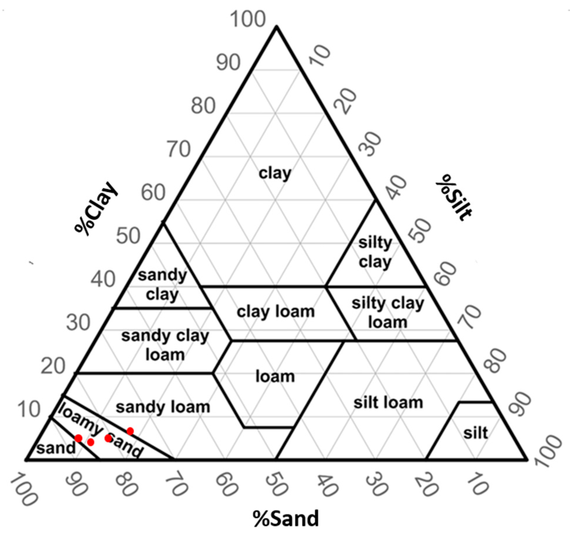
The soils are Orthents and Xerepts [71], with over 80% sand, 13% silt, and 7% clay. Soil texture ranges from sandy loam to sandy (Figure 2). Soil pH is 6.7, electric conductivity is 0.005 dS·m−1, and organic matter content is 0.48%. The erodibility factor, K [65], is 0.10 Mg·h·MJ−1·mm−1. This low soil erodibility value, coupled with the predominantly sandy texture of the soils, are crucial aspects in the present study and make it especially interesting since most gullies worldwide form on clayey or marly soils, and therefore, these gullies and badlands are the most commonly studied.
The topography of the study area and the region in which it is located exhibits substantial irregularity, characterized by elevated hills surpassing 1530 m above sea level, interconnected by steep slopes and valleys dissected by minor streams and ravines, descending to approximately 1100 m above sea level. While predominantly oriented southward, the terrain encompasses a variety of aspect orientations. An intricate network of erosional gullies is discernible across the elevational gradient between the aforementioned maxima and minima altitude. The average slope is 60%. In this province, the average erosion rate is 5.72 Mg·ha−1·yr−1, while gully erosion affects 2215.9 ha, representing 0.28% of the provincial surface area [72]. Within the region where the study area is located, the average erosion rate is 3.02 Mg·ha−1·yr−1 [72].
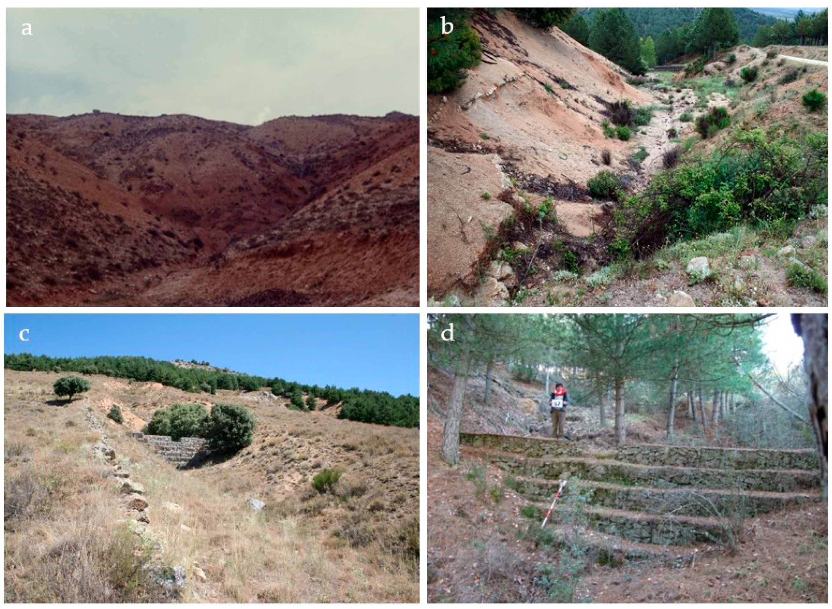
The native vegetation is mainly formed by Quercus rotundifolia Lam. forests, with Quercus pyrenaica Willd. dominating at higher elevations. However, continuous anthropogenic interventions have resulted in a highly degraded landscape, characterized by a sparse shrub stratum dominated by Thymus zygis Loefl. ex L., Lavandula stoechas Lam., and Cytisus scoparius (L.) Link. Presently, after five decades of hydrological-forestry restoration efforts (Figure 3), which commenced in 1964 and involved the planting of conifers on the slopes forming the gully catchments, a forest dominated by Pinus sylvestris L. and Pinus pinaster Ait. has established itself on severely degraded terrain previously occupied by impoverished steppe vegetation (Figure 4). This contemporary vegetation assemblage represents a replacement of the original native Quercus rotundifolia forest, a consequence of factors including agricultural practices, overgrazing, unsustainable timber, and fuelwood extraction, and wildfires. This area was intensively grazed for centuries by a significant number of sheep flocks, as shown by the location of a wool washing place dating back to the Middle Ages. Nowadays, land use is distributed as follows: pine forests (55%), scrubland and bare soil (38%), settlements and farmhouses (3%), rocky outcrops (2%), and oak forest (2%), while sheep farming is practically non-existent.

2.2. Data Collection

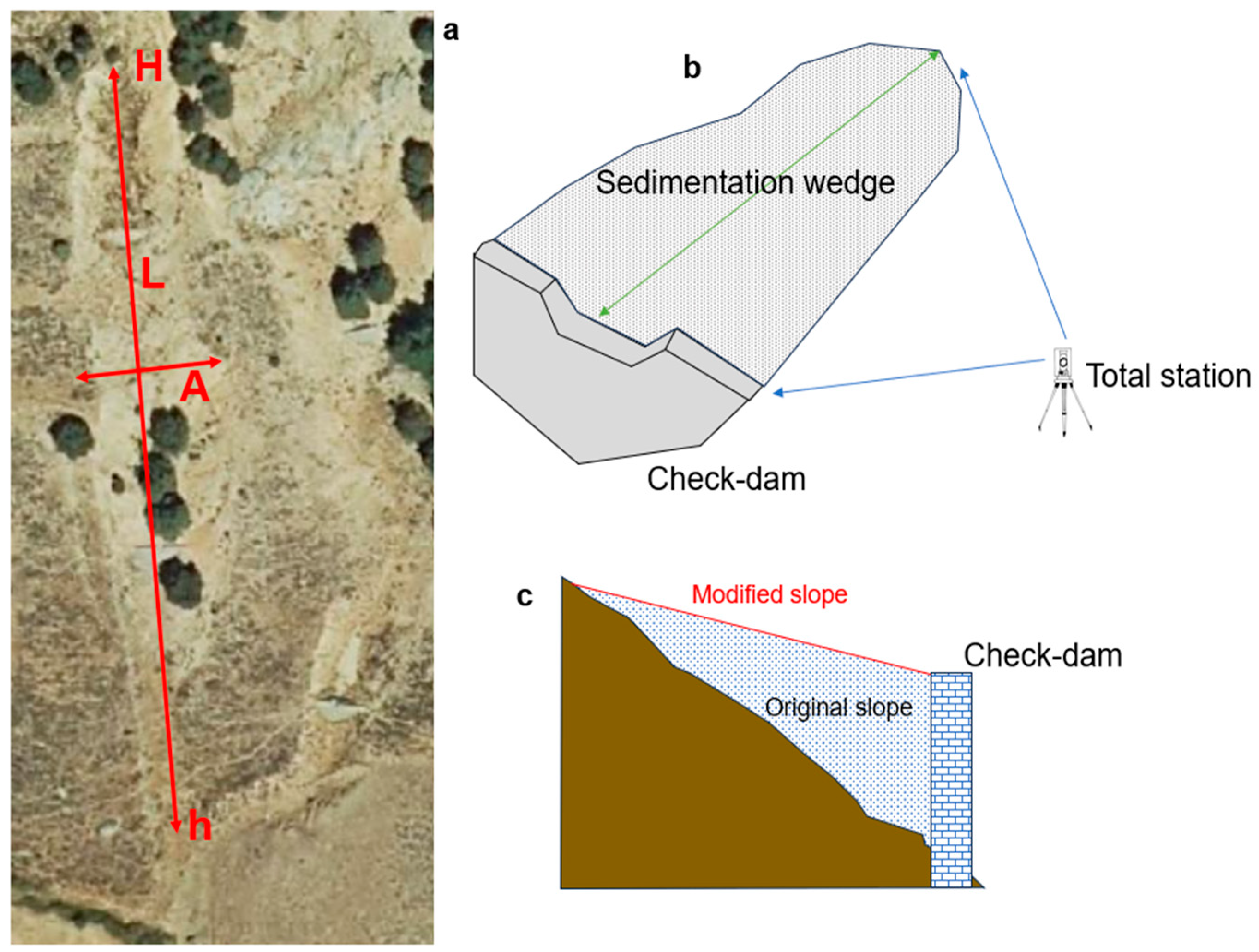
Forty-two gullies have been measured, whose location and distribution across the terrain are illustrated in Figure 1. Following the identification and delineation of gullies on aerial orthophotography at a 1:5000 scale (PNOA 2020), the subsequent parameters were measured in QGIS (v. 3.32.3):
-
Catchment Area: Determined using the basin measurement tool (SAGA 9.7.0).
-
Gully Length (L): Measured using the length measurement tool (SAGA 9.7.0).
-
Maximum Altitude (H) and Minimum Altitude (h) of the Gully: The highest and lowest points of each gully were identified on the orthophoto, and their elevations were obtained by overlaying the 1:5000 topographic map from the National Geographic Institute.
-
Mean Gully Width (W): Calculated as the mean between the maximum width and the minimum width, both measured in the field using a total station. This method was chosen for its simplicity and the precision offered by direct field measurement.
-
Mean Gully Depth (D): Also calculated as the mean between the maximum depth and the minimum depth, measured using a total station.
In addition, the following physical parameters have been calculated: relief amplitude (RA), gully slope (J), and drainage density (DD) (Equations (1)–(3)).
R A = H h
J = ( H h ) L
D D = L A
On the other hand, using a total station, the original slope of the gullies was measured by determining the maximum elevation at the end of the sedimentation wedge and the lowest elevation at the base of the check dam downstream, as well as the slope modified by the accumulation of sediment upstream of the check dams (Figure 5). In other words, the slope and length of the sedimentation wedge were measured, and the percentage length of the gully affected by the reduction in slope was then calculated. The analysis of slope reduction, through the measurement of the original and reduced gradients, is significant because this implies a decrease in the water flow velocity within the gully and its shear stress, as both of them are a function of the slope of the gullies (J).

2.3. Data Analysis

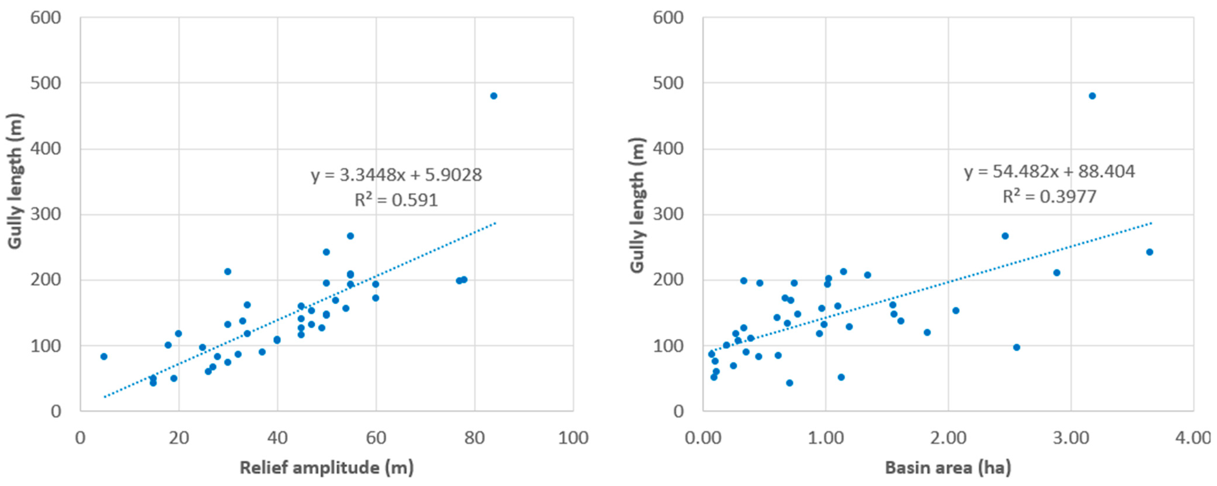
A descriptive statistical analysis was conducted to characterize the morphology of the studied gullies. This descriptive statistical analysis includes the mean, standard deviation (SD), median, and coefficient of variation, calculated for each analyzed variable (basin area, maximum elevation, minimum elevation, relief amplitude, gully length, gully slope, drainage density, mean gully width, number of check dams in each gully, mean slope reduction, length slope reduction, and affected length). Furthermore, a regression analysis was performed. Of all the variables, basin area and relief amplitude were selected against gully length, as they exhibited the highest regression coefficients. Statistical analyses were performed using IBM SPSS Statistics software (version 29.0.1.0).

3. Results

Table 1 and Table A1 show the topographic parameters of the measured gullies, specifically the catchment area to the lowest point of the gully (A), length (L), average width (W), maximum elevation (H), minimum elevation (h), and gully depth (D), as well as the calculated parameters: relief amplitude (RA), W/D, gully slope (J), and drainage density (DD). The catchment areas range from 0.07 to 3.65 ha, with a mean area of 1.04 ha. The mean maximum elevation is 1339 m, while the mean minimum elevation is 1297 m. The gullies have an average width of 4.3 m, an average length of 145 m, a mean depth of 2.32 m, and an average slope of 31%. The relief amplitude expresses the difference between the maximum and minimum elevations of the gully, and the mean value in this case is 41.6 m. Drainage density takes a mean value of 24.7 km·km−2, with this being a parameter that relates the length of the channel or channels that form the basin to the drainage area. These results delineate the principal geomorphological parameters of the studied gully set, which are situated within a distinctive combination of climate (mountainous Mediterranean-continental) and soil type (sandy).
The best correlations in the correlation analysis between different variables were basin area vs. gully length (correlation coefficient of 0.6306), relief amplitude vs. gully length (correlation coefficient of 0.7688), and slope vs. length (correlation coefficient of 0.4524). Figure 6 shows the scatter plots and regression equations of the first two pairs of variables mentioned. These correlations show that a direct linear relationship exists between the studied variables; more specifically, as the length of the gullies increases, an increase in relief amplitude is observed (the gullies exhibit a greater difference in elevation between their extreme points), along with an increase in the gully slope (precisely related to the difference in elevation) and an increase in the catchment area.
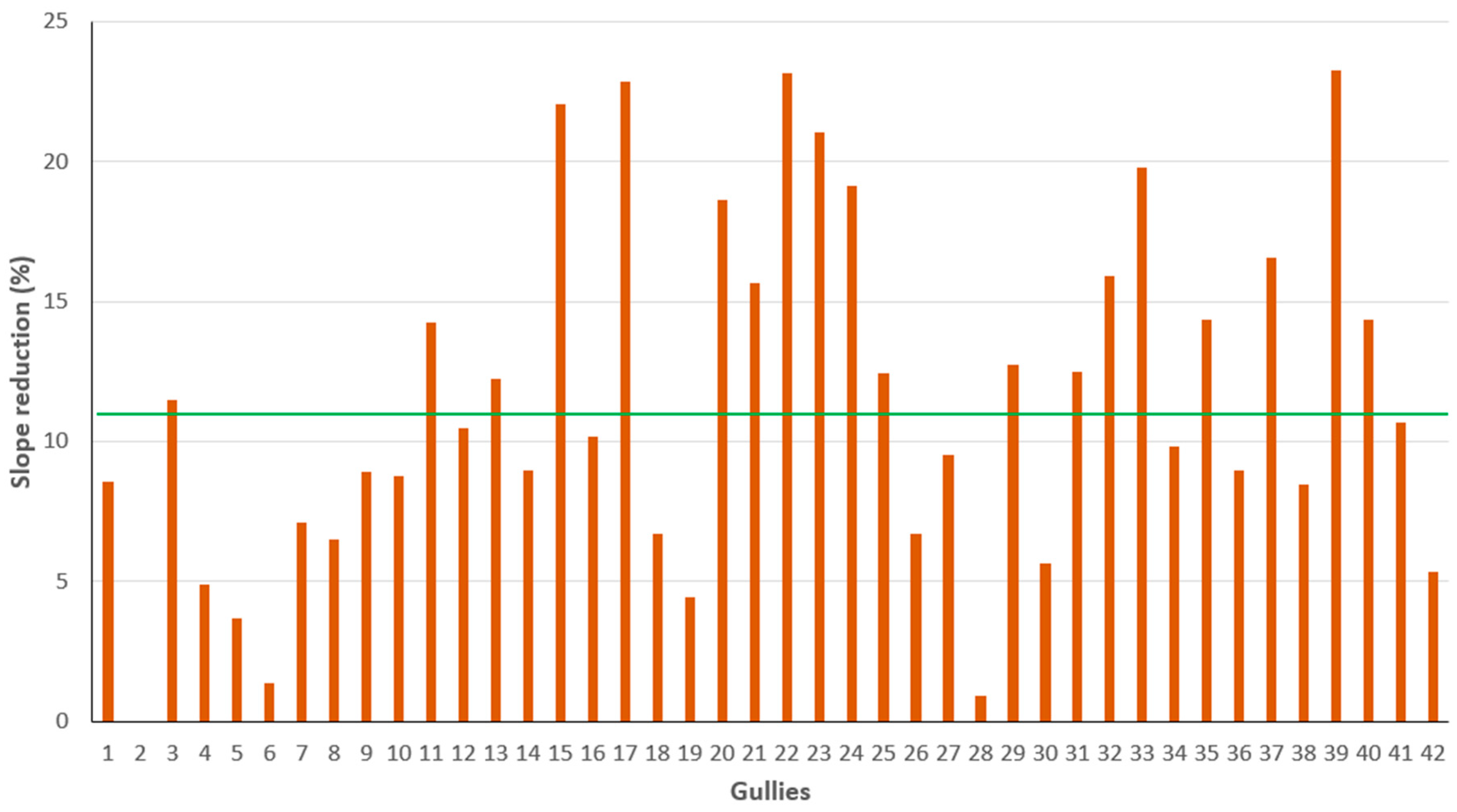
The related results to the reduction in gully slopes due to the construction of engineering measures, specifically check dams, are presented in Table 2 and Table A2. For each gully, the following information is provided: the number of check dams constructed in each gully (ranging from 1 to 12, with a median of 2 check dams per gully); the mean slope reduction, calculated as the ratio of the reduced slope to the original slope, expressed as a percentage (average value: 11.4%); the length along which the slope has been reduced; and the percentage of the total gully length affected by the reduction. On average, the slope reduction affected 15% of the gully length. These results indicate that the construction of check dams within the gullies considerably reduced the slope.
Figure 7 illustrates the slope reduction in the forty-two studied gullies, attributed to the construction of check dams. In some gullies, the slope reduction was significantly higher than the average, for example, in gully 39 (23.27%), gully 22 (23.18%), gully 17 (22.86%), and gully 15 (22.04%). Conversely, in gully 2, which has one check dam, no slope reduction was observed. In gullies 28 and 6, the reduction was very small (0.89% and 1.37%, respectively). Therefore, the reduction in slope was not uniform across all the gullies.

4. Discussion

Limited research has explored gullies in sandy and arkosic soils [59], with existing studies predominantly concentrating on geomorphological and geodynamic processes [60,61]. The study area of these cited works is located approximately 100 km east of the present study area; however, the geological materials differ, as in our case, the sandy materials (sand, loamy sand, and sandy loam textures) originate from the weathering of underlying granites, whereas the materials of the aforementioned studies correspond to siliceous and arkosic sands of the Upper Cretaceous age. This fact, together with the continentalized mountainous Mediterranean climate, with its moderate precipitation (571 mm) and evapotranspiration (659 mm) but significant summer drought and extreme temperatures in winter and summer, makes the gullies studied here form a characteristic and unique system that had not been analyzed until now. Indeed, in the Corneja River basin, a study was conducted on soil water infiltration, resulting in a mean steady-state infiltration rate of 404 mm·h−1 [11], a high value indicating that in this area, only very intense rainfall events generate runoff and mobilize solid particles.
Several authors have studied gully morphology [73,74,75,76]. Cheng et al. [73] measured the geomorphological characteristics of ephemeral gullies (length, distance between the headcut and the watershed divide, distance between neighboring gullies, slope gradient, drainage area, and flow erosivity) and established a relationship between the drainage area and slope gradient through an equation. Frankl et al. [75] utilized aerial photographs and satellite imagery to measure the length of permanent gullies and relate it to their volume, as well as to establish a relationship between the catchment area and the gully slope. They found that the factors determining gully morphological characteristics are lithology and the presence of check dams.
Geological materials or soils significantly influence the formation, development, and geomorphology of gullies [8,47,48]. In this regard, our study did not find the significant geological factors highlighted by some authors [16,50,53,61], such as surface crusts, piping processes, or soil sodicity. Similarly, significant mass movements were not observed, with the exception of low-intensity creeping on steeper slopes. Nevertheless, in the case of this gully set, the nature of the soil was crucial. Specifically, the sandy loam and sandy textures result in insufficient capillary water retention, which in turn leads to the removal of surface particles when intense rainfall generates runoff.
Martín-Moreno et al. [59] studied gullies formed on sands in an area located in the Eastern Iberian Peninsula, where rainfall occasionally exhibits higher intensities than in our study area. They found a mean annual sediment yield of 114 Mg·ha−1·yr−1; for the case under study, in a previous study conducted in the same area [77], the erosion rate, determined through the measurement of sediment volume accumulated in 123 check dams, is 5.65 Mg·ha−1·yr−1. This value is notably lower than the preceding data, potentially attributable to reduced soil erodibility and rainfall erosivity. Martín-Moreno et al. [59] highlighted the intense geomorphic activity within the gully, with an alluvial fan-type deposition in the check dams, something not found in our study area.
On the other hand, they established that the origin of these gullies is to be found in the deforestation produced between the 13th and 18th centuries when forests were intensively logged. This is one of the factors that, in our opinion, has the greatest influence on the formation of gullies in our study area. Here, as analyzed in other works, it has been established that erosion processes began to be significant in the 14th century when deforestation began to be intense in a process that extended until the end of the 19th century due to intensive grazing, tillage for livestock and crops, forest fires, and the irrational exploitation of firewood and timber [11]. Livestock farming in the area was very important throughout the Middle Ages, and likely until the mid-20th century. In fact, the remains of an old wool-washing structure on the Corneja River still exist. Although we have not found data on the number of sheep in the area, we do know that around the 14th century, there were around 8 million sheep in Spain. By the end of the 18th century, there were just over 17 million, and the peak number was in the 1940s, with 24 million sheep. It is estimated that 12,000 arrobas of wool (about 138 tons) were treated annually at this wash house during the Middle Ages. Given that a sheep produces about 5.5 kg of wool, it can be estimated that about 25,000 sheep grazed in the area studied [78]. According to Klein [79]: “In addition to the right to graze for their corrals, huts, fences, fires, etc., granted by the charter of 1273, shepherds used to burn trees during the fall to obtain better pastures in the spring, which led to great losses of Castilian forests due to the passage of millions of transhumant sheep” [79,80].
As previously indicated, Thwaites et al. [45], based on geomorphological characteristics, developed an elementary gully classification, incorporating criteria from other prior classifications. According to this classification, it can be asserted that the gullies observed in our study area can be classified as permanent (type-domain), linear and parallel (plan form), continuous (continuity), V-shaped (cross-section), sandy (soil type), and semi-active. Based on the literature, it can be stated that the triggering of gully erosion involves not only the material but also other factors such as the presence of intense rainfall and, above all, the loss of vegetation cover. However, the morphology of gullies is mainly conditioned by the characteristics of the soil, rocks, or sediments [81,82]. In this work, we have described the morphology of the gullies in the study area, with the unique soil and climate conditions already mentioned. The comparison of our results with those obtained by other authors is not easy, due to methodological differences. As an example, the results of this work have been compared with those presented by Wu et al. [81] in a study carried out in a Chinese region where the soils are Calcic Cambisols, noting that the gullies in the study area are longer (145.0 m vs. 58.4 m), narrower (4.3 m vs. 17.3 m), and shallower (2.3 m vs. 8.2 m), although the W/D ratio is very similar in both cases (2.0 vs. 2.2). In addition, the gullies described by Wu et al. [81] are of the “trellis” type, according to their plan form.
Regarding the role of check dams in slope reduction, Porto and Gessler [83] analyzed the slope of streams in the Calabria region (Italy), obtaining a mean slope reduction of 2.8% from the measurement of slopes achieved by 132 check dams located in 10 streams in the area. Roshani [84] observed a mean slope reduction of 7.6% thanks to the construction of check dams in the upper Rendam (Kan, Iran). In other research, Sobrino and Caba [85] obtained a slope reduction of between 8 and 10% thanks to five mass concrete check dams built in Saldes (Barcelona). In our study area, the slope reduction by check dams has been notably higher, with a mean reduction of 11.4% being found, reaching a maximum reduction of 23.3%. However, it is important to note that in the study area, the original slopes of the gullies are very steep (a mean of 28.2%) and that the slope reduction increases as the original slope increases [77].
Our analysis indicates that a higher quantity of check dams per gully does not automatically translate to a greater degree of slope reduction, diverging from initial expectations. It is pertinent to note that the magnitude of slope reduction is also influenced by factors such as the design and height of the check dams, which subsequently affect the length of the gully segment where the slope is reduced. Therefore, in accordance with the results obtained, although with non-uniform outcomes across all gullies, the effect of check dams in reducing gully slope is demonstrated, which is highly beneficial, as previously mentioned, for diminishing the erosive capacity of water flow and preventing gully progression. The shear stress of the runoff is directly related to the terrain slope (τ = γ·h·J), so a reduction in the slope (J) of between 23.3% and 11.4% diminishes the tractive force of the runoff (τ) in the same quantity.
This, combined with the stabilization of gully slopes provided by the check dams and the retention of sediments that do not reach rivers and reservoirs (in this case, according to [77], the 123 check dams trapped 5365.93 m3 of sediments, with a total sediment yield of 5.6 Mg·ha−1·yr−1), makes these elements a suitable solution for restoring gully-affected terrains [82] in the short term, which should be supported by forest cover restoration with a long-term objective [10,11,58].

5. Conclusions

Gully erosion presents a significant global challenge, capable of manifesting in diverse terrain types, including those of a sandy nature, as exemplified by the case study herein. Although less frequent in such soils, gullies exhibit distinctive processes and morphologies compared to those formed in other lithologies. This study measured and described the main geomorphological parameters of this particular set of gullies. Based on a thorough understanding of the area, it is established that, in this specific case, intense precipitation, steep slopes, sandy soils with insufficient capillary water retention, and extensive deforestation constitute the factors contributing to the generation and exacerbation of gullies.
Although further studies with similar methodologies are needed to enable better comparisons, this study has confirmed the morphological differences in gullies on sandy soils compared to Calcic Cambisols. Specifically, in the study area, gullies are of a linear and parallel type as opposed to “trellis” type gullies and are longer, narrower, and shallower, but with a similar W/D ratio.
The check dams constructed in the gullies substantially modify their morphology, particularly regarding their slope, which, in our case study, has been considerably reduced, with very positive consequences in reducing water flow velocity and its erosive capacity. Therefore, check dams are consolidated as an appropriate technique for gully restoration, combined with forest cover restoration. Furthermore, it has been observed that a greater number of check dams within each gully does not necessarily imply a more substantial reduction in slope, as other factors also influence slope reduction, such as the type or height of the check dam, which in turn affects the length of the gully benefiting from the slope reduction.
The results of this study are necessary for a better understanding of gullies formed on sandy materials and in a Mediterranean-continental climate, which therefore result in unique and still poorly understood formations. All of this can be used to plan control measures, prevent gully erosion, and undertake the restoration of areas with gullies with similar environmental configurations.

Author Contributions

Conceptualization, J.M.-M. and J.N.-H.; methodology, J.M.-M., V.D.-G. and A.-C.T.-R.; software, J.M.-M. and J.V.; validation, J.M.-M.; formal analysis, J.M.-M.; investigation, J.M.-M., J.N.-H. and V.D.-G.; resources, J.M.-M.; data curation, J.M.-M., V.D.-G. and A.-C.T.-R.; writing—original draft preparation, J.M.-M.; writing—review and editing, J.M.-M., J.N.-H., J.V., V.D.-G. and A.-C.T.-R.; visualization, J.M.-M.; supervision, J.M.-M.; project administration, J.M.-M. All authors have read and agreed to the published version of the manuscript.

Funding

This research received no external funding.

Data Availability Statement

The data and materials will be made available from the corresponding author upon reasonable request.

Acknowledgments

The authors wish to acknowledge the Catholic University of Ávila for the support received in conducting this study.

Conflicts of Interest

The authors declare no conflicts of interest.

Appendix A

Table A1. Main morphological parameters of the analyzed gullies.
GullyA
(ha)
H
(m)
h
(m)
RA
(m)
L
(m)
W
(m)
D
(m)
W/DJ
(%)
DD
(km·km−2)
10.62138013755832.802.051.376.0213.42
22.561395137025961.332.000.6726.043.75
31.0013721342301315.221.92.7422.9013.15
42.8914011346552092.001.91.0526.327.23
51.6213781345331362.271.91.1924.268.40
61.8313701350201181.511.21.2616.956.45
73.1813461262844792.942.81.0517.5415.06
80.9612961262341171.281.11.1729.0612.21
90.2013501332181006.202.62.3818.0050.08
100.7213521300521683.591.91.8930.9523.43
110.2913581318401072.591.61.6237.3836.47
120.071350131832865.151.653.1237.21118.62
130.4713511291601933.401.003.4031.0941.43
142.4713251270552663.291.62.0620.6810.77
150.251329130227673.853.11.2440.3026.60
160.7513351285501948.671.46.1925.7725.89
170.111276125026596.953.302.1144.0751.44
180.3413201275451264.162.61.6035.7137.60
190.9813451291541564.331.054.1234.6215.99
200.3413881311771983.752.41.5638.8958.32
211.0313891311782002.142.300.9339.0019.42
220.7813501300501464.583.21.4334.2518.82
231.5613351285501474.962.701.8434.019.42
240.351327129037892.603.160.8241.5725.31
250.6913071260471327.532.602.8935.6119.09
260.6813101250601714.162.61.6035.0925.31
271.15126012303021214.403.054.7214.1518.43
280.101335130515503.331.801.8560.0051.12
290.711312129715421.971.801.0935.715.89
300.2713401295451166.662.252.9638.7942.30
310.111325129530747.682.403.2040.5468.46
320.3913101270401095.652.502.2636.7027.78
330.6113201275451416.004.091.4731.9123.28
341.2013191270491274.602.102.1938.5810.58
351.0213401285551924.622.401.9228.6518.82
363.6513351285502413.353.500.9620.756.60
372.0713371290471524.162.701.5430.927.34
381.131330131119504.032.551.5838.004.42
391.1013381293451592.292.700.8528.3014.45
400.461338131028824.802.651.8134.1517.81
411.3513401285552064.972.851.7426.7015.26
421.5513191285341612.332.550.9121.1210.39
A: Basin area (ha); H: Maximum elevation (m); h: Minimum elevation (m); RA: Relief amplitude (m); L: Gully length (m); W: Mean gully width (m); D: Mean gully depth (m); J: Gully slope (%); DD: Drainage density (km/km2).
Table A2. Reduction in slope in the studied gullies.
GullyNCDOS (%)MSR (%)LSR (m)AF (%)
116.598.575.006.02
2126.040.000.000.00
3225.8711.4818.4014.05
4227.664.8812.556.00
5225.203.7015.7011.54
6317.181.3737.3031.61
71218.887.12128.4026.81
8331.096.5226.4022.56
9219.778.9359.0857.92
10833.928.7443.1025.65
11243.6014.265.184.84
12141.5710.495.706.63
13135.4212.245.803.01
14422.728.9830.9011.62
15351.6922.0412.9019.25
16228.6910.1712.906.65
17157.1322.865.809.83
18438.296.7233.1026.27
19136.224.434.502.88
20347.8018.6514.507.32
21646.2315.6417.008.37
22444.5823.1821.7514.90
23343.0921.0617.7012.04
24251.4019.135.606.29
25440.6612.4340.1430.41
26437.616.7233.1019.36
27115.649.5029.4013.87
28160.540.896.0012.00
29140.9212.722.926.95
30141.115.637.206.21
31246.3212.4714.5019.59
32343.6515.9339.9036.61
33139.7719.7611.908.44
34342.799.8330.8024.25
35233.4414.3419.059.92
36222.788.9430.5412.67
37337.0616.5637.2024.47
38141.518.4510.7021.40
39236.8923.2716.7010.50
40139.8614.338.009.76
41129.8910.699.804.76
42122.315.3411.407.08
NCD: Number of check dams in the gully; OS: Original slope (%); MSR: Mean slope reduction (%); LSR: Length slope reduction (m); AF: Affected length (%).

References

  1. Rubio, J.L. Desertification. Ambienta 2005, 47, 26–31. (In Spanish) [Google Scholar]
  2. MITERD. Inventario Nacional de Erosión de Suelos 2002–2022. Resumen; Ministerio para la Transición Ecológica y el Reto Demográfico: Madrid, Spain, 2022.
  3. Gómez, A.; Schnabel, S.; Lavado, F. Processes, factors, and consequences of gully erosion; studies conducted in the Iberian Peninsula. Bol. Asoc. Geógr. Esp. 2011, 55, 59–80. (In Spanish) [Google Scholar]
  4. Casalí, J.; López, J.J.; Giráldez, J.V. Ephemeral gully erosion in Southern Navarre (Spain): Description and quantification. Ing. Agua 1999, 6, 251–258. [Google Scholar]
  5. Rivera, J.H.; Sinisterra, J.A.; Calle, Z. Restauracion Ecológica de Suelos Degradados por Erosión en Cárcavas en el Enclave Xerofítico de Dagua, Valle del Cauca, Colombia; Fundación CIVAP: Cali, Colombia, 2007; Available online: http://www.cipav.org.co/noticias/noticias-n01.html (accessed on 9 April 2025).
  6. Hudson, N. Soil Conservation; Batsford: London, UK, 1995. [Google Scholar]
  7. Clarke, M.L.; Rendell, H.M. Process-form relationships in southern italian badlands: Erosion rates and implications for landform evolution. Earth Suf. Process. Landf. 2006, 31, 15–29. [Google Scholar] [CrossRef]
  8. FAO. Manual de sistemas de labranza para América Latina. Boletín Suelos FAO 1992, 66, 1–193. [Google Scholar]
  9. León, J.D. Strategies for gully erosion control and management. Cuad. Ambient. 2005, 2, 88–101. (In Spanish) [Google Scholar]
  10. Clotet, N.; Gallart, F.; Sala, M. Badlands: Characteristics, theoretical interest, dynamics, and erosion rates. Notes Geogr. Física 1987, 15–16, 28–37. (In Spanish) [Google Scholar]
  11. Clarke, M.L.; Rendell, H.M. Climate-driven decrease in erosion in extant Mediterranean badlands. Earth Surf. Process. Landf. 2010, 35, 1281–1288. [Google Scholar] [CrossRef]
  12. Simon, A.; Darby, S. The Nature and Significance of Incised River Channels. In Incised Rivers; Darby, S.E., Simon, A., Eds.; Jhon Wiley ans Sons Press: Chichester, UK, 1999. [Google Scholar]
  13. Zaimes, G.N.; Schultz, R.C.; Tufekcioglu, M. Gully and stream bank erosion in three pastures with different management in southeast Iowa. J. Iowa Acad. Sci. 2009, 116, 1–8. [Google Scholar]
  14. Moore, I.D.; Burch, G.J.; Mackenzie, D.H. Topographic effects on the distribution of surface soil water and the location of ephemeral gullies. Trans. ASAE 1988, 31, 1098–1107. [Google Scholar] [CrossRef]
  15. Poesen, J.; Govers, G. Gully Erosión in the Loam Belt of Belgium: Typology and Control Measures. In Soil Erosión on Agricultural Land; Boardman, J., Foster, I.D.L., Dearing, J.A., Eds.; John Wiley & Sons: Londres, UK, 1990. [Google Scholar]
  16. Foster, G.R. Understanding Ephemeral Gully Erosión. In Soil Conservation. Assesing the National Resources Inventory; Committee on Conservation Needs and Opportunities, Board on Agriculture, National Research Council, National Academy Press: Washington, DC, USA, 1986; Volume 2, pp. 90–125. [Google Scholar]
  17. Poesen, J. Gully Typology and Gully Control Measures in the European Loess Belt. In Farm Land Erosión in Températe Plains Environment and Hills; Wicherek, S., Ed.; Elsevier: Amsterdam, The Netherlands, 1993. [Google Scholar]
  18. Schumm, S.A. Causes and Control of Channel Incision. In Incised Rivers; Darby, S.E., Simon, A., Eds.; Jhon Wiley ans Sons Press: Chichester, UK, 1999. [Google Scholar]
  19. Núñez, J. Manejo y Conservación de Suelos; EUNED: San José, Costa Rica, 2001. [Google Scholar]
  20. FEDERACAFÉ. Manual de Conservación de Suelos de Ladera; Centro Nacional de Investigaciones del Café, Federación Nacional de Cafeteros de Colombia: Chinchiná, Colombia, 1975. [Google Scholar]
  21. Stocking, M.; Murnaham, N. Manual para la Evaluación de Campo de la Degradación de la Tierra; Mundi-Prensa Ed.: Madrid, Spain, 2003. [Google Scholar]
  22. Ciccacci, S.; Galiano, M.; Roma, M.A.; Salvatore, M.C. Morphological analysis and erosion rate evaluation in badlands of Radicofani area (Southern Tuscany-Italy). Catena 2008, 74, 87–97. [Google Scholar] [CrossRef]
  23. Yair, A.; Sharon, D.; Lavee, H. Trends in runoff and erosion processes over an arid limestone hillside, northern Negev, Israel. Hydrol. Sci. J. 1980, 25, 243–255. [Google Scholar] [CrossRef]
  24. López-Bermúdez, F.; Torcal, L. Tunnel erosion (piping) processes in sedimentary basins of Murcia (Spain). Preliminary study using X-ray diffraction and scanning electron microscopy. Papeles Geogr. Física 1986, 11, 7–20. [Google Scholar]
  25. Benito, G.; Gutiérrez, M.; Sancho, C. Erosion rates in badland areas of the central Ebro basin (NE Spain). Catena 1992, 19, 269–286. [Google Scholar] [CrossRef]
  26. Navarro, J.; Serrano, C.; Ugalde, M.; Oria de Rueda, J.A.; Jonte, M.A. Utilización de Geotextiles en la Corrección de Cárcavas del Cristo del Otero (Palencia); I Congreso Forestal Hispano-Luso: Pamplona, Spain, 1997. [Google Scholar]
  27. Cantón, Y.; Domingo, F.; Solé-Benet, A.; Puigdefábregas, J. Hydrological and erosion response of a badlands system in semiarid SE Spain. J. Hydrol. 2001, 252, 65–84. [Google Scholar] [CrossRef]
  28. Martín-Duque, J.F. Erosión Hídrica en Cárcavas y Barrancos de la Provincia de Segovia, España; Geología & Yacimientos Minerales: Madrid, Spain, 2007; Available online: www.aulados.net (accessed on 9 April 2025).
  29. Martínez-Casasnovas, J.A.; Ramos, M.C.; García-Hernández, D. Effects of land-use changes in vegetation cover and sidewall erosion in a gully head of the Penedés region (Northeast Spain). Earth Surf. Process. Landf. 2009, 34, 1927–1937. [Google Scholar] [CrossRef]
  30. Fournier, F. Climat et Érosion; Presses Universitaires de France: Paris, France, 1960. [Google Scholar]
  31. Wischmeier, W.H.; Smith, D.D. Predicting Rainfall Erosion Losses. A Guide to Conservation Planning; USDA Agricultural Handbook, No. 537; USDA: Washington, DC, USA, 1978.
  32. ICONA. Agresividad de la Lluvia en España. Valores del Factor R de la Ecuación Universal de Pérdidas de Suelo; Instituto para la Conservación de la Naturaleza, Ministerio de Agricultura, Pesca y Alimentación: Madrid, Spain, 1988. [Google Scholar]
  33. Thornthwaite, C.W. An approach towards a rational classification of climate. Geogr. Rev. 1948, 38, 55–94. [Google Scholar] [CrossRef]
  34. UNEP. World Atlas of Desertification, 2nd ed.; United Nations Environment Programme: London, UK, 1997. [Google Scholar]
  35. Lang, R. Versuch einer exakten Klassifikation der Boden in klimatischer Hinsicht. Interne Mitt. Boden-Kunde 1915, 5, 312–346. [Google Scholar]
  36. IGME. Mapa Geológico de España. Escala 1:50.000. Santa María del Berrocal; Instituto Geológico y Minero de España: Madrid, Spain, 2008. [Google Scholar]
  37. Soil Survey Staff. Keys to Soil Taxonomy, 12th ed.; United States Department of Agriculture, Natural Resources Conservation Service: Washinton, DC, USA, 2014. [Google Scholar]
  38. Guanglu, L.; Klik, A.; Faqi, W. Gully Erosion Features and its Causes of Formation on the (Yuan) Land in the Loess Plateau, China. In Gully Erosion Under Global Change; Li, Y., Poesen, J., Valentin, C., Eds.; Sichuan Science and Technology Press: Chengdu, China, 2004. [Google Scholar]
  39. Tebebu, T.Y.; Abiy, A.Z.; Zegeye, A.D.; Dahle, H.E.; Easton, Z.M.; Tilahun, S.A.; Collick, A.S.; Kidnau, S.; Moges, S.; Dadgari, F.; et al. Surface and subsurface flow effect on permanent gully formation and upland erosion near Lake Tana in the northern highlands of Ethiopia. Hydrol. Earth Syst. Sci. 2010, 14, 2207–2217. [Google Scholar] [CrossRef]
  40. Ogbonna, U. Understanding gully erosion vulnerability in Old Imo State using geographic information system and geostatistics. Am. J. Geogr. Inf. Syst. 2012, 1, 66–71. [Google Scholar]
  41. Shit, P.K.; Bhunia, G.S.; Maiti, R. Assessment of factors affecting ephemeral gully development in badland topography: A case study at Garbheta Badland (Pashchim Medinipur, West Bengal, India). Int. J. Geosci. 2013, 4, 461–470. [Google Scholar] [CrossRef]
  42. Addis, H.K.; Adugna, B.; Gebretsadik, M.; Ayalew, B. Gully morphology and rehabilitation measures in different agroecological environments of Northwestern Ethiopia. Appl. Environ. Soil Sci. 2015, 2015, 789479. [Google Scholar] [CrossRef]
  43. Rustomji, P. Analysis of gully dimensions and sediment texture from southeast Australia for catchment sediment budgeting. Catena 2006, 67, 119–127. [Google Scholar] [CrossRef]
  44. Radoane, M.; Radoane, N. Chapter 16. Gully erosion. In Landform Dynamics and Evolution in Romania; Radoane, M., Vespremeanu-Stroe, A., Eds.; Springer Geography: Geneve, Switzerland, 2019. [Google Scholar]
  45. Navarro, J.; De Araújo, J.C.; Mongil, J. Assessment of 80 years of ancient-badlands restoration in Saldaña, Spain. Earth Surf. Process. Landf. 2014, 39, 1563–1575. [Google Scholar]
  46. Mongil-Manso, J.; Navarro-Hevia, J.; Díaz-Gutiérrez, V.; Cruz, V.; Ramos-Díez, I. Badlands forest restoration in Central Spain after 50 years under a Mediterranean-continental climate. Ecol. Eng. 2016, 97, 313–326. [Google Scholar] [CrossRef]
  47. Martineli, C.F.; De Almeida-Prado, L. Analysis of the influence of gully erosion in the flow pattern of catchment streams, Southeastern Brazil. Catena 2007, 69, 230–238. [Google Scholar] [CrossRef]
  48. Strunk, H. Soil degradation and overland flow as causes of gully erosion on mountain pastures and in forests. Catena 2005, 50, 185–198. [Google Scholar] [CrossRef]
  49. Mongil-Manso, J.; Díaz-Gutiérrez, V.; Navarro-Hevia, J.; Espina, M.; San Segundo, L. The role of check dams in retaining organic carbon and nutrients. A study case in the Sierra de Ávila mountain range (Central Spain). Sci. Total Environ. 2018, 657, 1030–1040. [Google Scholar] [CrossRef]
  50. Poesen, J.; Nachtergaele, J.; Verstraeten, G.; Valentin, C. Gully erosion and environmental change: Importance and research needs. Catena 2003, 50, 91–133. [Google Scholar] [CrossRef]
  51. Valentin, C.; Poesen, J.; Li, Y. Gully erosion: Impacts factors and control. Catena 2005, 63, 132–153. [Google Scholar] [CrossRef]
  52. Poesen, J. Challenges in gully erosion research. Landf. Anal. 2011, 17, 5–9. [Google Scholar]
  53. Radoane, M.; Ichim, I.; Radoane, N. Gully distribution and development in Moldavia, Romania. Catena 1995, 24, 127–146. [Google Scholar] [CrossRef]
  54. Castaldi, F.; Chiocchini, U. Effects of land use changes on badland erosion in clayey drainage basins, Radicofani, Central Italy. Geomorphology 2012, 169–170, 98–108. [Google Scholar] [CrossRef]
  55. Martín-Moreno, C.; Fidalgo-Hijano, C.; Martín-Duque, J.F.; González-Martín, J.A.; Zapico-Alonso, I.; Laronne, J.B. The Ribagorda sand gully (east-central Spain): Sediment yield and human-induced origin. Geomorphology 2014, 224, 122–138. [Google Scholar] [CrossRef]
  56. Lucía, A.; Martín-Duque, J.F.; Laronne, J.B.; Sanz-Santos, M.A. Geomorphic dynamics of gullies developed in sandy slopes of Central Spain. Landf. Anal. 2011, 17, 91–97. [Google Scholar]
  57. Lucía, A.; Laronne, J.B.; Martín-Duque, J.F. Geodynamic processes on sandy slope gullies in central Spain field observations, methods and measurements in a singular system. Geodin. Acta 2012, 24, 61–79. [Google Scholar]
  58. Cheng, H.; Zou, X.; Wu, Y.; Zhang, C.; Zheng, Q.; Jiang, Z. Morphology parameters of ephemeral gully in characteristics hillslopes on the Loess Plateau of China. Soil Tillage Res. 2007, 94, 4–14. [Google Scholar] [CrossRef]
  59. Heede, B.H. Morphology of gullies in the Colorado Rocky Mountains. Hydrol. Sci. J. 1970, 15, 79–89. [Google Scholar] [CrossRef]
  60. Frankl, A.; Poesen, J.; Scholiers, N.; Jacob, M.; Haile, M.; Deckers, J.; Nyssen, J. Factors controlling the morphology and volume (V)–length (L) relations of permanent gullies in the northern Ethiopian Highlands. Earth Surf. Process. Landf. 2013, 38, 1672–1684. [Google Scholar] [CrossRef]
  61. Ding, L.; Qin, F.C.; Fang, H.D.; Liu, H.; Zhang, B.; Shu, C.Q.; Deng, Q.C.; Liu, G.C.; Yang, Q.Q. Morphology and controlling factors of the longitudinal profile of gullies in the Yuanmou dry-hot valley. J. Mt. Sci. 2017, 14, 674–693. [Google Scholar] [CrossRef]
  62. Thwaites, R.N.; Brooks, A.P.; Pietsch, T.J.; Spencer, J.R. What type of gully is that? The need for a classification of gullies. Earth Surf. Process. Landf. 2022, 47, 109–128. [Google Scholar] [CrossRef]
  63. Fenneman, N.M. Physiographic provinces and sections in western Oklahoma and adjacent parts of Texas. Bull. U.S. Geol. Surv. 1922, 730, 126–129. [Google Scholar]
  64. MAAMA. National Soil Erosion Inventory 2002–2012. 2011, Ávila, Castilla y León; Ministerio de Agricultura, Alimentación y Medio Ambiente: Madrid, Spain, 2012. (In Spanish) [Google Scholar]
  65. Higgins, C.G.; Hill, B.R.; Lehre, A.K. Chapter 6. Gully Development. In Groundwater Geomorphology; The Role of Subsurface Water in Earth Surface Processes and Landforms; Higgins, C.G., Coates, D.R., Eds.; The Geological Society of America Special Paper 252; Geological Society of America: Boulder, CO, USA, 1990. [Google Scholar]
  66. Ireland, H.; Sharpe, C.F.S.; Eargle, D.H. Principles of Gully Erosion in the Piedmont of South Carolina; Tech. rep.; USDA: Washington, DC, USA, 1939.
  67. Sumner, M.E.; Stewart, B.A. (Eds.) Soil Crusting: Chemical and Physical Processes; Lewis: Boca Raton, FL, USA, 1992. [Google Scholar]
  68. Rengasamy, P. Sodic Soils, Processes, Characteristics, and Classification. In Encyclopedia of Soil Science; Lal, R., Ed.; Marcel Dekker: New York, NY, USA, 2002. [Google Scholar]
  69. Faulkner, H. Piping hazard on dispersive and collapsible soils in Europe. In Soil Erosion in Europe; Poesen, J., Boardman, J., Eds.; John Wiley: Chichester, UK, 2006. [Google Scholar]
  70. Barranco, D. The Chuy flour mill, in Bonilla de la Sierra (Ávila): Analysis historical-descriptive and its temporal evolution (XII–XXI centuries). Cuad. Abulenses 2019, 48, 11–64. (In Spanish) [Google Scholar]
  71. Faulkner, H. Badlands in marl lithologies: A field guide to soil dispersion, subsurface erosion and piping-origin gullies. Catena 2013, 106, 42–53. [Google Scholar] [CrossRef]
  72. Bernatek-Jakiel, A.; Poesen, J. Subsurface erosion by soil piping: Significance and research needs. Earth Sci. Rev. 2018, 185, 1107–1128. [Google Scholar] [CrossRef]
  73. Rienks, S.M.; Botha, G.A.; Hughes, J.C. Some physical and chemical properties of sediments exposed in a gully (donga) in northern KwaZulu-Natal, South Africa and their relationship to the erodibility of the colluvial layers. Catena 2000, 39, 11–31. [Google Scholar] [CrossRef]
  74. Brooks, A.P.; Shellberg, J.G.; Knight, J.; Spencer, J. Alluvial gully erosion across the Mitchell fluvial megafan, Queensland Australia. Earth Surf. Process. Landf. 2009, 34, 1951–1969. [Google Scholar] [CrossRef]
  75. Kasanin-Grubin, M.; Bryan, R. Lithological properties and weathering response on badland hillslopes. Catena 2004, 70, 68–78. [Google Scholar] [CrossRef]
  76. Díaz-Gutiérrez, V.; Mongil-Manso, J.; Navarro-Hevia, J.; Ramos-Diez, I. Check dams and sediment control: Final results of a case study in the upper Corneja River (Central Spain). J. Soils Sediments 2018, 19, 451–466. [Google Scholar] [CrossRef]
  77. Klein, J. La Mesta; Alianza Universidad: Madrid, Spain, 1981. [Google Scholar]
  78. Estévez, J.J. Sheep livestock in the History of Spain. Anales de la Real Academia de Ciencias Veterinarias de Andalucía Oriental; Real Academia de Ciencias Veterinarias de Andalucía Oriental: Granada, Spain, 1990; pp. 21–46. (In Spanish) [Google Scholar]
  79. Wu, H.; Xu, X.; Zheng, F.; Qin, C.; He, X. Gully morphological characteristics in the loess hilly-gully region based on 3D laser scanning technique. Earth Surf. Process. Landf. 2018, 43, 1701–1710. [Google Scholar] [CrossRef]
  80. Yibeltal, M.; Tsunekawa, A.; Haregeweyn, N.; Adgo, E.; Meshesha, D.T.; Masunaga, T.; Tsubo, M.; Billi, P.; Ebabu, K.; Fenta, A.A.; et al. Morphological characteristics and topographic thresholds of gullies in different agro-ecological environments. Geomorphology 2019, 341, 15–27. [Google Scholar] [CrossRef]
  81. Nyssen, J.; Veyret-Picot, M.; Poesen, J.; Moeyersons, J.; Haile, M.; Deckers, J.; Govers, G. The effectiveness of loose rock check dams for gully control in Tigray, northern Etiopia. Soil Use Manag. 2004, 20, 55–64. [Google Scholar] [CrossRef]
  82. Lucas-Borja, M.E.; Piton, G.; Yu, Y.; Castillo, C.; Zema, D.A. Check dams worldwide: Objetives, functions, effectiveness and undesired effects. Catena 2021, 204, 105390. [Google Scholar] [CrossRef]
  83. Porto, P.; Gessler, J. Ultimate bed slope in Calabrian streams upstream of check dams: Field study. J. Hydraul. Eng.-ASCE 1999, 125, 1231–1242. [Google Scholar] [CrossRef]
  84. Roshani, R. Evaluating the Effect of Check Dams on Flood Peaks to Optimize the Flood Control Measures (Kan Case Study in Iran). Master’s Thesis, International Institute for Geo-Information Science and Earth Observation Enschede, Enschede, The Netherlands, 2003. [Google Scholar]
  85. Sobrino, M.A.; Caba, J. Análisis Comparativo a Nivel Técnico y Económico de Distintas Tipologias de Solución para la Corrección Hidrológica en las Cabeceras de las Cuencas de Alta Montaña en la Comarca del Berguedá. (Barcelona); VI Congreso Iberoamericano de Control de la Erosión y los Sedimentos: Granada, Spain, 2012. [Google Scholar]
Figure 1. Location of the study area in the River Duero basin (Coordinates: UTM zone 30N, Datum ETRS89).
Geosciences 15 00208 g001
Figure 2. Soil textural diagram of the study area.
Geosciences 15 00208 g002
Figure 3. Details of the gullies near the village of Tórtoles. 1973 aerial orthophoto (Coordinates: UTM zone 30N, Datum ETRS89). Reforestation strips and terraces implemented in 1964 can be observed at the gully heads. The objective of these reforestation efforts was the restoration of forest cover and the reduction in sediment generation, as it had been observed that substantial quantities of sediment from this gullied area were reaching the reservoir of Santa Teresa, located several kilometers downstream.
Geosciences 15 00208 g003
Figure 4. Examples of gullies: (a) Gully in 1964 before the restoration project; (b) Gully no. 9; (c) Gully no. 36; (d) Check dam no. 57 in gully no. 10.
Geosciences 15 00208 g004
Figure 5. Gully measurement procedure. (a) On aerial orthophotography and topographic map, the gully length (L), mean width (W), upper elevation (H), and lower elevation (h) are measured; (b,c) using a total station, the sedimentation wedge length, original slope, and modified slope are measured.
Geosciences 15 00208 g005
Figure 6. Scatter plots: relief amplitude vs. gully length and catchment area vs. gully length.
Geosciences 15 00208 g006
Figure 7. Reduction in slope in the gullies, attributed to the construction of check dams. The green line indicates the mean reduction (11.40%).
Geosciences 15 00208 g007
Table 1. Descriptive statistics of the main morphological parameters of the analyzed gullies.
A
(ha)
H
(m)
h
(m)
RA
(m)
L
(m)
W
(m)
D
(m)
W/DJ
(%)
DD
(km·km−2)
Mean1.041338.881296.9541.57144.954.332.321.9631.1524.68
SD0.8829.6631.5717.3975.642.390.691.129.6521.75
Median0.761337.501292.0045.00134.004.092.401.6132.9618.63
Max3.651401.001375.0084.00479.0014.44.096.1960.00118.62
Min0.071260.001230.005.0042.001.281.000.676.023.75
CV84.362.222.4341.8252.1855.1829.7457.3330.9788.13
A: Basin area (ha); H: Maximum elevation (m); h: Minimum elevation (m); RA: Relief amplitude (m); L: Gully length (m); W: Mean gully width (m); D: Mean gully depth (m); J: Gully slope (%); DD: Drainage density (km/km2).
Table 2. Descriptive statistics for the parameters of reduction in slope in the studied gullies.
NCDOS (%)MSR (%)LSR (m)AF (%)
Mean2.5535.5611.4021.3914.77
SD2.1111.666.2321.6611.19
Median2.0037.3310.3315.10134.00
Max12.0060.54 23.27128.4057.92
Min1.006.590.000.000.00
CV82.7932.8054.66101.2675.75
NCD: Number of check dams in the gully; OS: Original slope (%); MSR: Mean slope reduction (%); LSR: Length slope reduction (m); AF: Affected length (%).
Disclaimer/Publisher’s Note: The statements, opinions and data contained in all publications are solely those of the individual author(s) and contributor(s) and not of MDPI and/or the editor(s). MDPI and/or the editor(s) disclaim responsibility for any injury to people or property resulting from any ideas, methods, instructions or products referred to in the content.