Article

Tectonic Evolution and Structural Control of Dike-Hosted Orogenic Gold Deposits in the Yana–Kolyma Collision Orogen (Eastern Siberia): Insights from the Eastern Margin of the Siberian Craton

by
Valery Yurievich Fridovsky
* and
Maxim Vasilievich Kudrin
*
Diamond and Precious Metal Geology Institute, Siberian Branch of the Russian Academy of Sciences, 677000 Yakutsk, Russia
*
Authors to whom correspondence should be addressed.
Geosciences 2025, 15(5), 168; https://doi.org/10.3390/geosciences15050168
Submission received: 15 March 2025 / Revised: 20 April 2025 / Accepted: 23 April 2025 / Published: 7 May 2025
(This article belongs to the Section Structural Geology and Tectonics)

Abstract

:
The Yana–Kolyma collision orogen, Eastern Siberia, is one of world-class gold economic belts, where large gold deposits are localized, mainly in the Upper Paleozoic and Lower Mesozoic clastic rocks. Dike-hosted orogenic gold deposits are found and to a lesser extent studied, but they are important for understanding the structural control of mineralization within the framework of the orogen. Orogenic gold deposits of the Vyun ore field are hosted in Kimmeridgian–Titonian mafic, intermediate and felsic dikes, but they have no genetic connection with dikes. The late formation of deposits led to the fact that previously reactivated polydeformed structures were subsequently mineralized. The study of the structural control of mineralization is also complicated by superimposed late tectonic events. Based on the analysis of collected field materials, this paper presents the results of the study of deformation structures of the Vyun ore field within the framework of the Mesozoic evolution history throughout the geological time of the eastern convergent margin of the Siberian Craton. Four stages of deformations are identified. The pre-mineralization deformations and metamorphic and magmatic events share a common NE-SW shortening (D1 phase), which is related to the subduction of the Oymyakon oceanic slab and collision of the Kolyma–Omolon superterrane from the eastern margin of the Siberian Craton. This first stage is characterized by the superposition of several tectonic events under conditions of compression and progressive deformations (D1/1 and D1/2). Ore mineralization was formed at the end of compression in the same stress field (D1/2). Its structural control is determined by reactivation of older dikes and faults. Dikes are areas of heterogeneous stress and heterogeneous strain, being favorable for the concentration of ore fluids. The metallogenic time of formation of the gold mineralization is synchronous with the tectonic event, which likely reflects the final stages of the Kolyma–Omolon microcontinent–Siberian Craton collision of the Valanginian during crustal thickening. The main impulse of the Au mineralization D1/2 phase coincided with a slowdown in convergence. The post-mineralization tectonic regime was related to the Aptian–Late Cretaceous tectonic transition from compression to transpression. Transpressional tectonics were determined accordingly by W-E (D2 phase) and N-S (D3 phase) stress fields caused by several accretion events in the Cretaceous on the northern and eastern margins of Siberia. D4 phase extensional structures were caused by the opening of the Eurasian Oceanic basin in the Arctic in the Paleocene. The obtained results have a first-order impact on the understanding of the structural control of orogenic gold deposits and their relationship to the evolution of the host orogen. The new findings improve the tectonic knowledge of an area of interest for ore deposit exploration targeting orogenic gold deposits in Phanerozoic terranes of craton margins.

1. Introduction

The eastern margin of the Siberian Craton (Figure 1) is known for world-class orogenic gold deposits (OGDs) (review in [1,2,3,4,5,6,7]). Most of the deposits are located in the Yana–Kolyma orogenic belt (YKOB), where they are located on a NW-striking structure along regional faults in the Upper Permian–Lower Jurassic terrigenous strata (Natalka, Degdekan, Pavlik, Drazhnoye, Badran, Malo-Tarynskoye, Khangalas, and others). In there, dikes hosting gold deposits are also known (Utinskoye, Sturmovskoye, Srednekanskoye, Krokhalinnoye, Berezitovoye, and others). Less common are intrusion-related deposits (Shkolnoye, Butarnoye, Ekspeditsionnoe, Ergelyakh, and others) [8,9,10]. Interest in them was aroused by the successful development of economically important deposits such as Fort Knox, Pogo, and Dublin Gulch in the Tintina gold belt in Alaska and Yukon [11]. A close spatial relationship between OGDs and intrusive rocks is also observed in other Au provinces worldwide (for example, the Hillgrove gold–antimony deposit of the New England Orogen [12], Woods Point dike swarm of eastern Victoria, Australia [13], and many others). Dike-hosted OGDs are widespread in the Jurassic deposits of the Upper Kolyma sector of the YKOB. Some of the largest of these deposits were developed in the 1930s to 1950s [14]. Attention to gold mineralization in dikes and small magmatic bodies has emerged in recent years [14,15,16,17]. One of these deposits is the Vyun ore field, located in the western sector of the YKOB (Figure 1).
The Vyun deposit was discovered in 1974 by L.P. Komarova and F.I. Shatrov. During 1975–1980, exploration and evaluation work was carried out. In the 1990s, exploration work was carried out by trenching and underground mining workings; estimated reserves of ~2.5 tons of Au with a content of 7.5 g/t have been calculated. The exploitation continued in 2005–2009 by Yanskaya Mining Company JSC, in 2017–2020 by Dalzoloto LLC, and a factory was built. In 2020–2021, gold mining was carried out underground. The main emphasis in the research of YKOB gold mineralization, spatially associated with dikes and small magmatic bodies, was placed on the features of the deposit geology, the mineralogy and paragenetic sequence, the conditions of their formation [14,15,16,17], geochemistry, and the geochronology and petrology of spatially associated magmatism [17,18]. However, the structural control in the mineralization development is not clear, and the relationship of the dikes with the orogen evolution is debated.
As part of the evolution of the host orogen, these deposits are usually formed in a suprasubduction and seldom in a collisional geodynamic setting before orogenic collapse [2,3,19,20,21,22,23,24]. OGD mineralization occurring during rapid uplift in the orogeny in the SW Pacific is also described [12]. The late periods of the formation of deposits lead to the fact that reactivated previously repeatedly deformed structures turn out to be mineralized. The study of the structural control of mineralization is also complicated by superimposed late tectonic events.
Figure 1. Generalized geological map showing major tectonic structures and metallogeny of Eastern Siberia (a) (revised and supplemented from [6,25]) and (b) Regional geologic map of the Kular–Nera and Polousno–Debin terranes, showing position of the Vyun ore field, main rock units, structures, and the distribution of deposits Au and Au-Sb (revised and supplemented from [17,18]). Abbreviations: SK—Siberian Craton; VFTB—Verkhoyansk fold-and-thrust belt; KNT—Kular–Nera terrane; PDT—Polousno–Debin terrane; OMT—Omulevka terrane; OmCT—Omolon craton terrane; OCT—Okhotsk craton terrane; KOS—Kolyma–Omolon superterrane; Mesozoic–Cenozoic orogenic belts: YKOB—Yana–Kolyma; ACO—Arctic and Chukotka; OK—Olyutor–Kamchatka; OKO—Okhotsk–Koryak; KR—Koryak; MKBB—Late Jurassic Main Kolyma batholitic belt (red cross line); UYVB—Late Jurassic Uyandina–Yasachnaya volcanic belt (blue check mark line). Faults: AT—Adycha–Taryn; Chi—Charky-Inyali; N—Nera; Kh—Khangalas; Chb—Chibagalakh; CHI—Charky–Indigirka thrust.
Geosciences 15 00168 g001
This paper includes the study of the deformation structures of the Vyun ore field in the context of the Mesozoic evolution on the eastern convergent margin of Siberia. In the Vyun ore field, two terranes are separated by the regional thick Charky–Indigirka thrust (CHI) (Figure 1). Along this main tectonic contact, several tectonic events are documented, including the emplacement of dikes and the related mineralization. Orogenic gold ore mineralization in dikes is not typical for the YKOB. For this reason, the analysis of the relationship between polydeformed structures and associated mineralization is a key argument that is tentatively unraveled in this work.

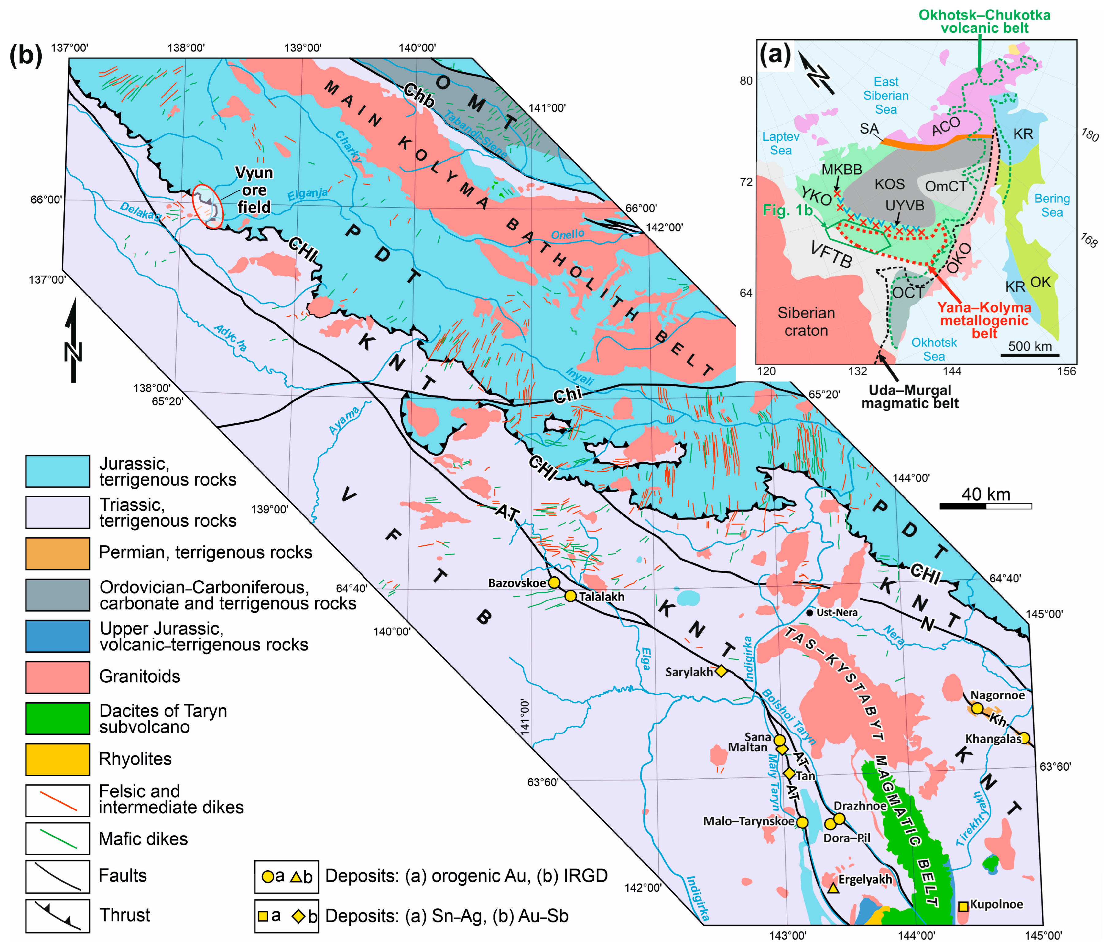
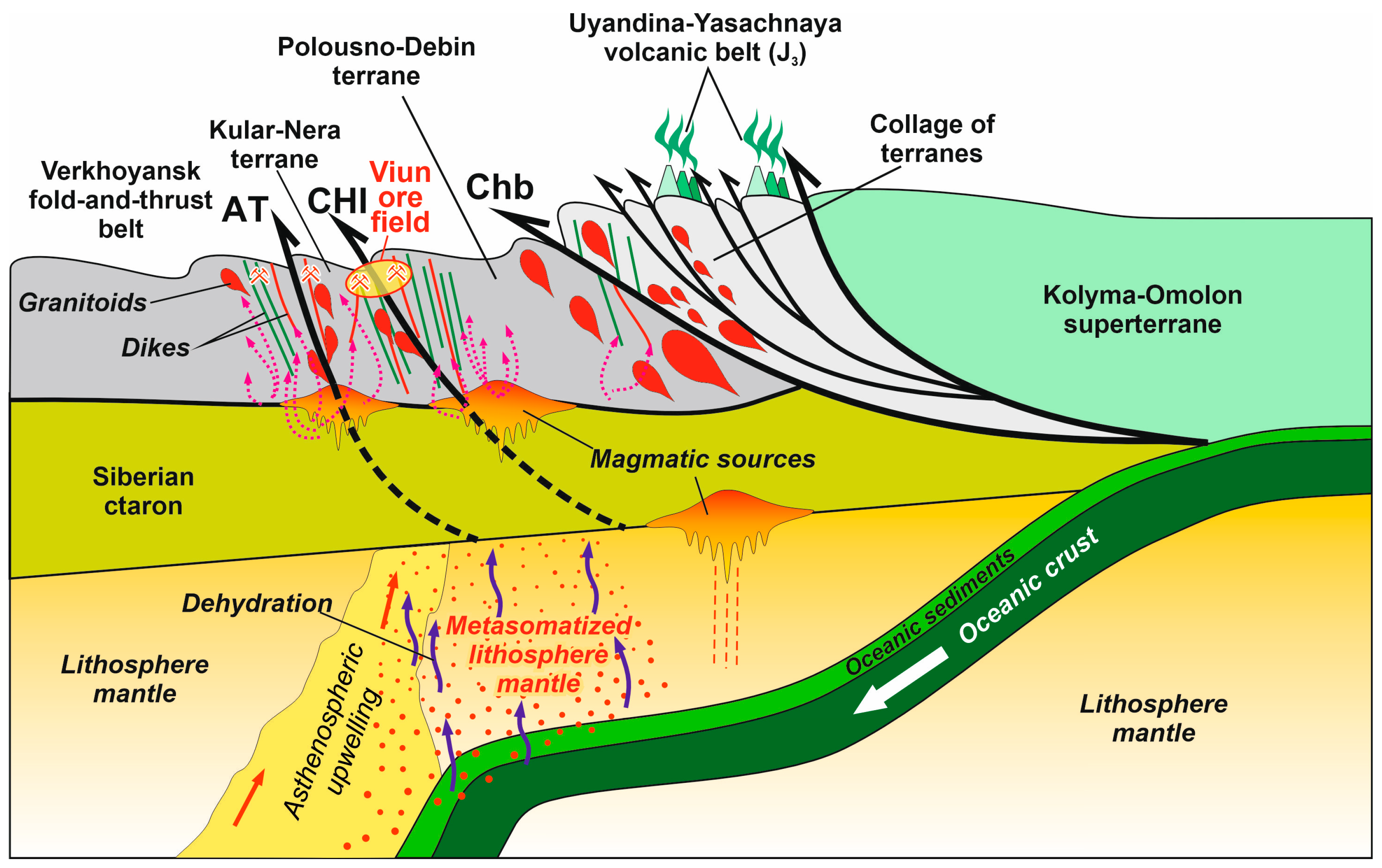
2. Regional Geology, Magmatism, and Metallogenic Setting

2.1. Regional Geology

One of the major Late Mesozoic gold-forming episodes in Siberia and East Asia is related to the evolution of the YKOB [2,3,6,26,27,28]. The orogen is located between the Verkhoyansk fold-and-thrust belt (VFTB) of the eastern margin of the Siberian Craton and the structures of the Kolyma–Omolon superterrane (KOS) (microcontinent) (Figure 1a). It is part of the Verkhoyansk–Chukotka province of the Mesozoic–Cenozoic collages comprising the Precambrian cratonic terranes and accreted the Late Paleozoic to Cenozoic turbidite to island arc terranes [25,26]. Deformation processes, magmatism, and metallogenesis in the YKOB in the Late Jurassic–Valanginian is related to the closure of the small Oymyakon paleo-ocean and the subsequent collision of the KOS and the eastern margin of the Siberian Craton [2,26,29]. At the beginning of the Early Cretaceous, the collision process spread towards the Siberian platform and was accompanied by the formation of the VFTB [26]. At the end of the Early Cretaceous and after the closure of the South Anyu Ocean, the collision of the Chukotka microcontinent (a fragment of the Arctic Alaska–Chukotka microplate) with the structures of the Paleo-Arctic active margin of Siberia occurred [25,26]. The Cretaceous tectonic–thermal events were also caused by continuous subduction of the Paleo-Pacific plate on the eastern margin of Siberia [26,27].
The main structures of central part of the YKOB are determined by systems of extended faults (Adycha–Taryn, Charky–Indigirka and others) and linear folds. Differently directed movements are identified along the faults–early thrust of several generations and late sinistral and dextral strike-slip faults. Transverse NE and NS faults (oblique ramps), mainly of strike-slip and normal strike-slip fault kinematics, dividing the thrusts into separate segments, are also identified [5,18,30].
The YKOB includes several Late Jurassic terranes; the main ones are Kular–Nera and Polousno–Debin [25,26]. The Kular–Nera terrane (KNT) consists of sequences of Upper Permian, Triassic, and Lower Jurassic terrigenous sedimentary rocks corresponding to the distal clastic deposits of the continental slope and foot of the Siberian Craton passive continental margin [26,31]. These rocks are metamorphosed to lower greenschist facies conditions [26]. The KNT can be traced in the NW direction for a distance of about 1100 km, has a width from 10–20 to 100–150 km [26]. From the southwest of the adjacent structures of the Verkhoyansk fold-and-thrust belt, the KNT is separated by the trans-crustal Adycha–Taryn fault. This is an important metallogenic structure with Au, Au-Sb, W-Sn, and Mo-W mineralization. The latter is 40 km wide and over 1500 km long, including the Ten’ka fault to the southeast and the Baky–Bytantay fault to the northwest. From the northeast, the Triassic clastic sediments of the Kular–Nera region are separated by the CHI from the Jurassic clastic sediments of the Polousno–Debin terrane (PDT). The magnitude of the thrust movement is up to 35–50 km [32]. In the area of the Kolyma Loop, the thrust strike changes from NW to N and NE, and it is called the Lower-Yana (Yana) overthrust fault with displacement up to 90–100 km [33]. In this segment, the overthrust fault is involved in the distribution of Au-Sb-Hg mineralization. The CHI is an important fault zone associated with intense folding and tectonic breccia zones tens, sometimes hundreds, of meters thick. Associated with the decollements, early thrust and late mainly strike-slip movements are identified. A zone of pyritization of rocks with a thickness from several tens to a few hundred meters is associated with the thrust. The content of sulfides is generally less than 1%, but may locally increase to 10%.
The PDT is mainly composed of Upper Triassic–Jurassic clastic rocks. To the east, they are replaced by the Paleozoic and Early Mesozoic volcano-sedimentary sequences of the Nagondzhinsky and Omulevka terranes [26]. The PDT and KNT structures are cut by transverse and diagonal faults that control a trending magmatic series of granitoids and dike swarms. These transverse faults show strike-slip kinematics (e.g., Chibagalakh fault) (Figure 1b).
The KOS, located to the northeast, is formed by a collage of terranes of various geodynamic origins, amalgamated in the Middle Jurassic (continental, oceanic, and island arc terranes) [25,26,27,34].

2.2. Magmatism

Most of the magmatic formations of the YKOB and adjacent areas belong to the Main Kolyma batholith belt (MKBB) and Uyandina–Yasachnaya volcanic belt (UYVB), which stretch along the Polousno–Kolyma suture, on the border of the eastern margin of the Siberian craton and the KOS [17,18,26,27]. Orthogonally to the MKBB are located the transverse magmatic series.

2.2.1. Main Kolyma Batholith Belt

The MKBB has a length of about 1110 km with a width of 150 to 200 km (Figure 1). The total area of granitoids on the daytime surface is about 73,000 km2. The area of individual plutons is up to several hundred km2. They form one of the largest salic igneous provinces (SLIPs) of Central and Northeast Asia [35]. The batholiths of this belt are composed mainly of granodiorites and granites, intruding the rocks of marginal–continental terranes and fragmentary volcanogenic–sedimentary formations of the Uyandina–Yasachnaya volcanic arc [36]. The U-Pb age of zircons from the granitoids of the MKBB is in the range of 158–144 Ma (Kimmeridgian–Berriasian), peak 150 ± 3 Ma [36,37,38]. The 40Ar/39Ar cooling time of granitoids by biotites is 143–138 Ma [18,39] and reflects the completion time of the superterrane collision with the Siberian Craton. These granitoids correspond to the S- and I-geochemical types of granites [2]. Their formation is considered as in connection with the collision of the KOS with the margin of the Siberian Craton [26,27,40], as well as subduction-related, which is confirmed by their close age to the Uyandina–Yasachnaya volcanic arc [37].

2.2.2. Uyandina–Yasachnaya Volcanic Belt

The UYVB (1000 km long and 150 km wide) is located parallel to the MKBB on its northeastern flank (Figure 1). Volcanogenic sedimentary and volcanogenic rocks with a thickness of several hundred meters to 3500 m consist of basalts, andesites, rhyolites, tuffs of different compositions, and associated sedimentary rocks [41,42]. They fragmentally overlap the Lower–Middle Paleozoic carbonate–terrigenous and carbonate rocks, and to a lesser extent the Upper Paleozoic–Lower Mesozoic fine detrital rocks, of the Omulevka terrane and adjacent sections of the PDT [25,26]. The U-Pb age for zircons from acidic and intermediate volcanic rocks of this belt is in a narrow range, 153 ± 2 Ma [43,44], close to the crystallization age of plutons of granitoids of the MKBB [37,38]. The formation of the UYVB is related to a subduction zone [26], in which the direction of dipping under the Siberian Craton was westward, which is argued by many researchers [17,18,31,36,45,46].

2.2.3. Transverse Magmatic Series

The YKOB records widely distributed transverse, northeast-trending magmatic series of granitoids and dike swarms, orthogonal to the main northwestern tectonic structures of the central part of the Kular–Nera and Polousno–Debin terranes and the MKBB (Figure 1a) [17,18,36]. The series begin from the MKBB and cross-structures of the Polousno–Debin and Kular–Nera terranes and fade to the southwest in the hinterland structures of the VFTB. Areas of intersection of the NW regional faults and the transverse series of granitoids and dikes are spatially associated with mineralization of the Late Jurassic–Early Cretaceous Yana–Kolyma Metallogenic belt (YKMB).

2.3. Regional Metallogeny

The ore deposits of the YKMB include, in fact, orogenic (Au, Sn-Ag) and post-orogenic (Au-Ag, Au-Sb, and Ag-Sb, Sn) deposits [2,25,47].

2.3.1. Orogenic Metallogeny

Many large Au deposits belong to the orogenic metallogeny (Natalka, Pavlik, Degdekan, Drazhnoye, Malo-Tarynskoye, Badran, etc.). They are mainly localized in trans-crustal fault zones or subsidiary faults in clastic Upper Paleozoic rocks, less often in dikes and small intrusive bodies [2,3,6,7]. There are also small occurrences of intrusion-related classes Au deposits (Shkolnoe, Butarnoe, Ekspeditsionnoe, Ergelyakh, etc.) [8,9]. The available data on isotope dating of ores from OGDs of the Yana–Kolyma belt form two clusters at 142–148 and 130–138 Ma [2,18,30,48]. Early and late orogenic deposits have similar mineralogical and geochemical compositions; they were formed in a compressional condition D1/2 phase. The isotope geochemistry of these deposits is characteristic of metamorphic and sub-crustal ore-forming systems [6,7,49]. The deposits were formed at the end of the collision of the KOS and the eastern margin of the Siberian Craton. The Berriasian Sn-Ag mineralization (Kupolnoe) is localized in the hornfels of granitoid massifs [25].

2.3.2. Post-Orogenic Metallogeny

Post-orogenic metallogeny is related to the development in the Cretaceous of an active Andean-type continental margin in Eastern Siberia and the formation of the Uda–Murgal and Okhotsk–Chukotka volcanic–magmatic arcs by continuous subduction of the slab of the Paleo-Pacific plate [50]. Au-Ag, Au-Sb, Ag-Sb, and Sn mineralization occurred, forming metallogenic zones both independent and superimposed on the orogenic Au mineralization.
There are several metallogenic zones within the western sector of the YKMB (Inyali–Debin, Olchan–Nera, and Adycha–Tarynskaya) [36]. Deposits and occurrences of the Vyun ore field, considered in this article, are located on the border of Olchan–Nera and Adycha–Tarynskaya metallogenic zones.

2.4. District Geology and Mineralization

The tectonic style of the Vyun ore field is determined by NW-SE-striking fault structures and related folds, transverse NE faults, and the structures of the CHI (Figure 2) [17]. In the footwall of the thrust, the Upper Triassic terrigenous deposits of the KNT are exposed, in hanging-wall Jurassic sandstones with layers of siltstones and mudstones of the PDT. The ore-hosting Upper Triassic deposits of the Nyakuninskaya formation are divided into three sub-formations. Lower and upper sub-formations have a siltstone–mudstone composition with a subordinate role of sandstones. The middle sub-formation is characterized by alternating layers of sandstones and siltstones.
Figure 2. Simplified geologic map of the Vyun ore field, showing the position of the Vyun deposit and the Shumny area, main rock units, and structures (revised and supplemented from [17,18]). Diagrams show bedding poles (a,e,i,m,q), poles of dikes (b,f,j,n,r), faults (c,g,k,o), and poles of quartz veins and veinlets (d,h,l,p,s). The plottings are made on the upper hemisphere of the Wulff net. Symbols in diagrams and figures here and hereafter are as follows: dashed line—πS-circle; empty circles—calculated position of the fold hinges (b); solid black lines—position of fault or ore zone (S); yellow dots with line/arrow—projections of slickenlines (l); blue empty squares—bedding (S0) poles; green dots—poles of dikes (D); red crosses—poles of quartz veins and veinlets (V); dashed orange line in diagrams (i,p)—the zone of poles of quartz veins (plane σ3/σ1); n—number of measurements. Explanations in the text.
Geosciences 15 00168 g002
The Vyun ore field has the primary Vyun gold deposit and several ore occurrences (Vyun-II, Vyun-III, Shumny, Daikovoe, Andrey, and Krutoy) (Figure 2). The latter two are localized in faults; the rest are confined to dikes. Geological characteristics, ore mineralogy, wall-rock alterations of the Vyun deposit, and Shumny ore occurrence are described by many authors [15,51] and are typical of OGDs [2,52].
Ore veins and disseminated refractory ores hosted in dike and clastic rocks comprise the main ores (Figure 3). Quartz, carbonate–quartz, and chlorite–carbonate–quartz veins are confined to dikes and seldom to faults. The disseminated ores are confined to arsenopyrite–pyrite–sericite–carbonate–quartz gangues [15,51]. The thickness of the sulfidization zone can reach up to several tens of meters. The content of sulfides usually does not exceed 1–3%; in local areas it increases to 10%. Several generations of pyrite are described: synsedimentary/diagenetic Py1, metamorphic Py2, metasomatic arsenian Py3 and Apy1, and veined Py4 and Apy2 [51]. Ores contain native gold of high/medium fineness (800–900‰) in quartz veins and invisible gold in arsenian Py-3 and Apy-1. The host rock alterations have an arsenopyrite–pyrite–sericite–carbonate–quartz composition [51]. Similar changes are typical for the OGD of the YKMB (e.g., Khangalas, Badran, and Malo-Tarynskoye) [6,53]. The gangue consists of quartz and minor carbonate [15]. Sulfides in ore bodies are unevenly distributed, and their content does not exceed 1–3%. Arsenopyrite prevails among the ore minerals. Less commonly noted are pyrite, galena, sphalerite, chalcopyrite, antimonite, native gold, and sulfosalts (tetrahedrite, freibergite, argentotetrahedrite, and bournonite). Four ore and two post-ore different paragenetic sequences of mineral formation were macroscopically and microscopic studied in the Vyun ore field [15]. The ore paragenetic sequences are pyrite–arsenopyrite metasomatic, pyrite–arsenopyrite–quartz, chalcopyrite–sphalerite–galena–quartz, and fahlore–quartz. The post-ore stages include stibnite–carbonate–quartz and oxide oxidation zones. Enriched subcrustal lithospheric mantle and metamorphic systems were probably the main source of sulfur, gold, and mineralizing fluids of the mineralization of the Vyun ore field, as well as for other OGDs of the YKMB [6,7,25,49]. The Au content in pyrite in altered rock after dikes was between 0.3 and 53.9 ppm and after sandstones and siltstones between 0.3 and 159.5 ppm; the content in arsenopyrite in altered rock after sandstones and siltstones was between 28.9 and 58.4 ppm [51].
Terrigenous rocks of the Vyun ore field are intruded by Late Jurassic–Early Cretaceous dikes and massifs of granitoids of the small intrusion complex (Figure 2) [17,18]. The compositions of dikes include trachybasalts, trachyandesites, dacites, and granodiorites. The dikes are usually subvertical and associated with different fault generations. The dikes are boudinaged and curved. Individual dikes have been traced to a distance of 4.0–4.5 km, and their thickness ranges between tens of cm and 5–7 m, though seldom reaches 30–40 m. Dike bodies, like small massifs, have an NE strike, and they form the Nitkan transverse belt, which is 10–15 km wide and 30–40 km long. The NE strike of the dikes dominates in both walls of the Chakry–Indigirka thrust, and fewer dikes have sublatitudinal and NW strikes. At the stage of formation of the gold mineralization, dikes, as well as faults, drove the fluid circulation. The dikes have been transformed into a quartz–sericite–chlorite–carbonate aggregate with sulfide dissemination.
All the mafic, intermediate, and felsic dikes have close trace element contents, which are also close to those of the Late Jurassic mafic and felsic dikes and small intrusions. These trace element concentrations correspond to rocks between the E-MORB and OIB, with middle ocean ridge basalt (MORB)-like HREE content [17]. The U–Pb SHRIMP-II dates obtained for the dikes corresponded to the Late Jurassic interval of 151–145 Ma (Figure 2) [17].
The Bukeschen small granodiorite massif has an area up to 6 × 3 km2 (Figure 2) [18]. The Bukeschen massif is composed of diorites, quartz diorites, granodiorites, leucocratic granites, subalkaline granites, and leucogranites. The concordant age for the peripheral parts of zircon grains from the granodiorite of the Bukeschen massif is 144.5 ± 0.9 Ma [18]. Similar geochemical and isotopic (Sm-Nd and Rb-Sr) characteristics have been determined for granitoids of the Bukeschen massif and Late Jurassic dikes of various compositions [17,18].

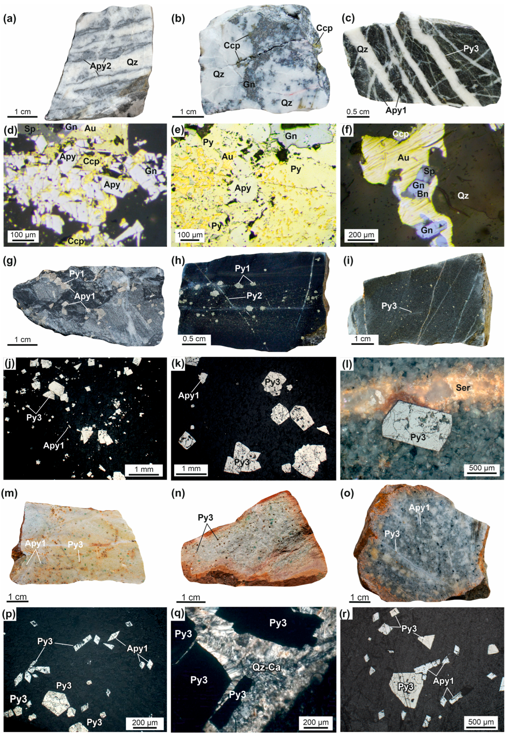
3. Materials and Methods

This work was based on detailed field work, observations of ore bodies, and their relationship with tectonic structures (folds, faults, foliations, and kinematic indicators). Structural–kinematic studies in the Vyun ore cluster were conducted using up-to-date methods [5,54,55,56,57,58]. The morphology of ore veins in natural exposures was studied and their relations with geological structures and dikes were also established. Measurements of planar and linear structures (bedding, cleavage, vein–veinlet bodies, faults, ore zones, jointing, fold hinges, boudinage, slickenlines, etc.) were performed. The slip direction was determined using several types of kinematic indicators—slickenlines, drag folds, tension gashes, and others. The kinematics of main deformation stages and the paleo-orientation of stress were reconstructed relative to major deformation structures of NW strike. Structural data were statistically analyzed and plotted on the upper hemisphere of the Wulff stereographic net. The nomenclature of structural elements is taken from [5,7]. Planar structures (i.e., S0—bedding; V—veins; S—faults/cleavage; and D—dike) are given as the dip azimuth/dip angle (e.g., 60/70 denotes an eastward dip at 70). In the vein indexes V11 and V12, the first digit indicates the relative time of the deformation event, the second the system of structural elements to which the vein belongs. For example, in this case, the veins are related to the first stage of deformations D1 and belong to the first and second systems, respectively. For linear structures (i.e., b—fold axes; L—boudinage; and l—slickenlines), the denotation plunge azimuth/plunge angle is used (e.g., 110/50 means a plunge azimuth of 110 and plunge angle of 50). Signs S1 and l1 denote the relation of a structural element to a particular deformation stage (D1) event. The determination of the σ1–σ3 orientations was carried out using methods [54,55].

4. Results

The Vyun ore field is one of the key areas of the YKOB to study the tectonic and metallogenic evolution structures between the Kular–Nera and Polousno–Debin terranes. In the ore field, these tectonic units are separated by the CHI, in which the paraauotochthon and auotochthon have different structures and metallogeny. Mapping of geological structures shows many superimposed structures, which reflect a long-term multiphase (pre-mineralization, mineralization, and post-mineralization) deformation history (Figure 2).

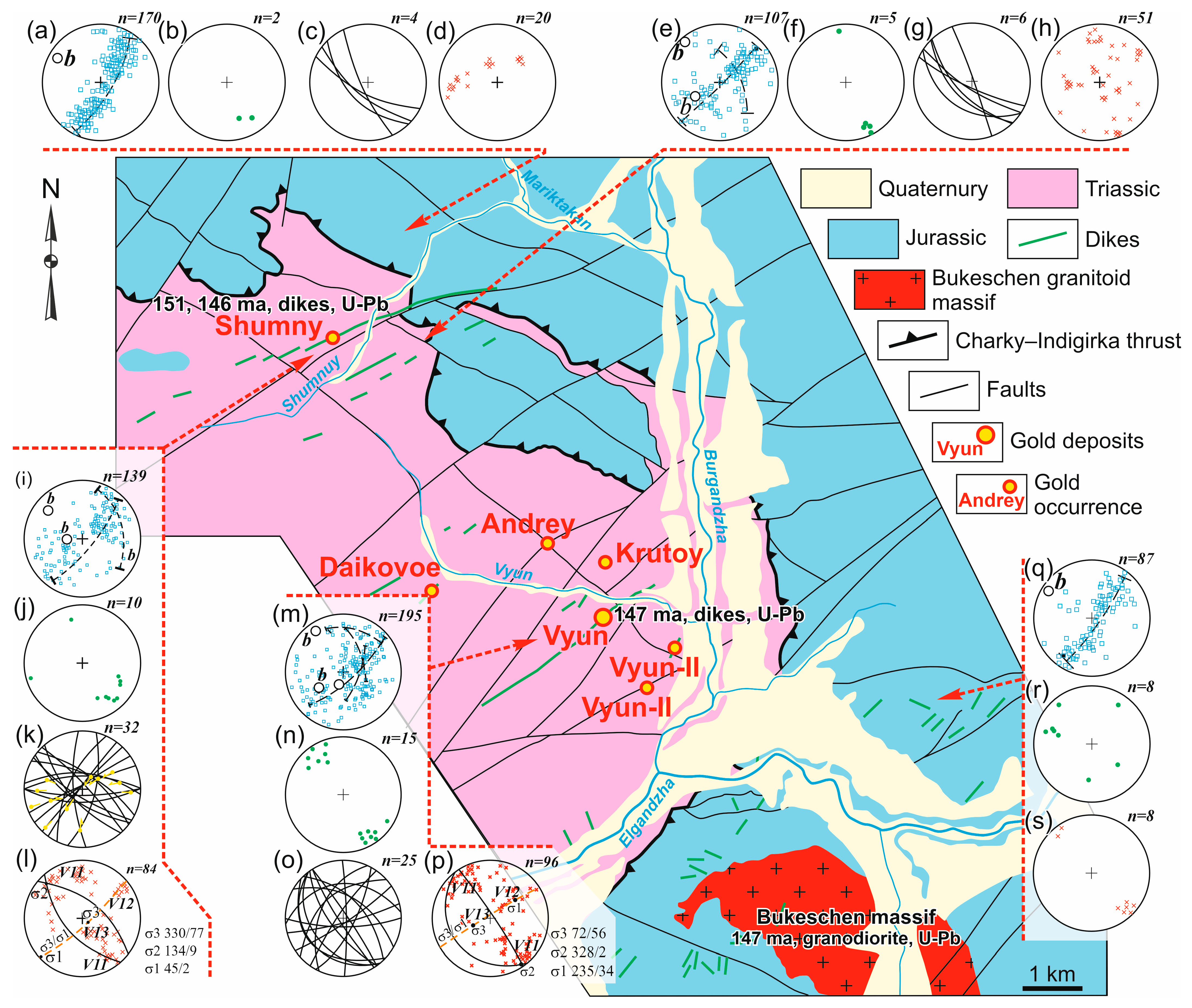
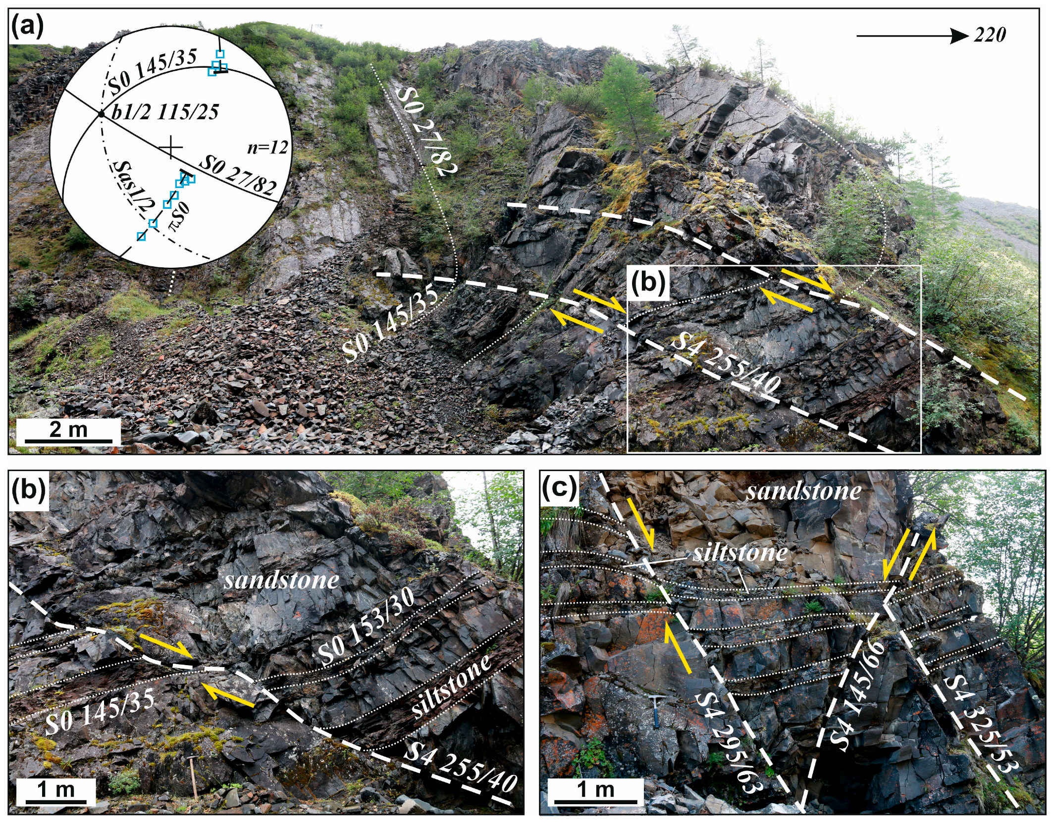
4.1. Structural Analysis of Two Au Districts in the Parautochthon of the Charky–Indigirka Thrust

In the parautochthon of the CHI, there are the Vyun gold deposit (65°97′33.3″ N, 138°25′06.1″ E) and the Shumny gold area (66°01′58.7″ N, 138°14′90.4″ E).

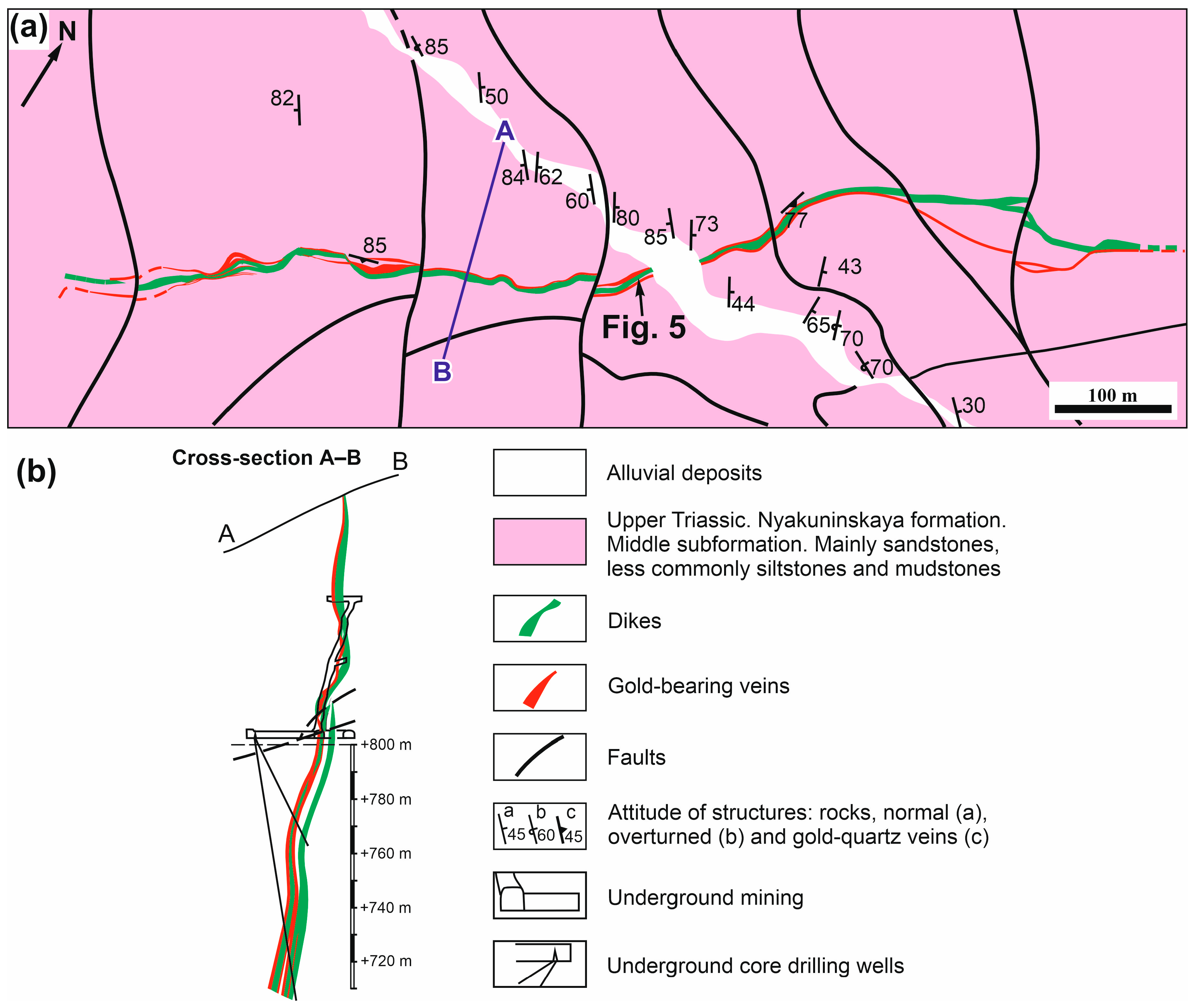
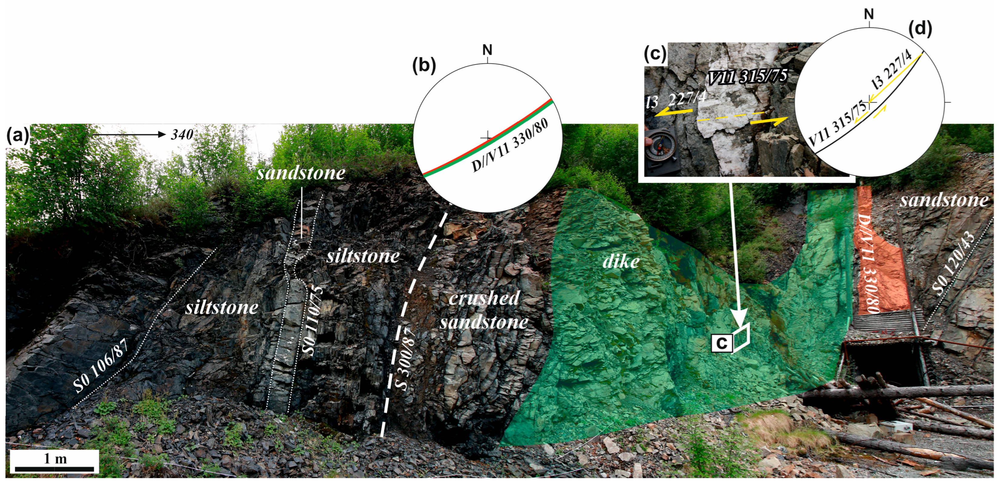
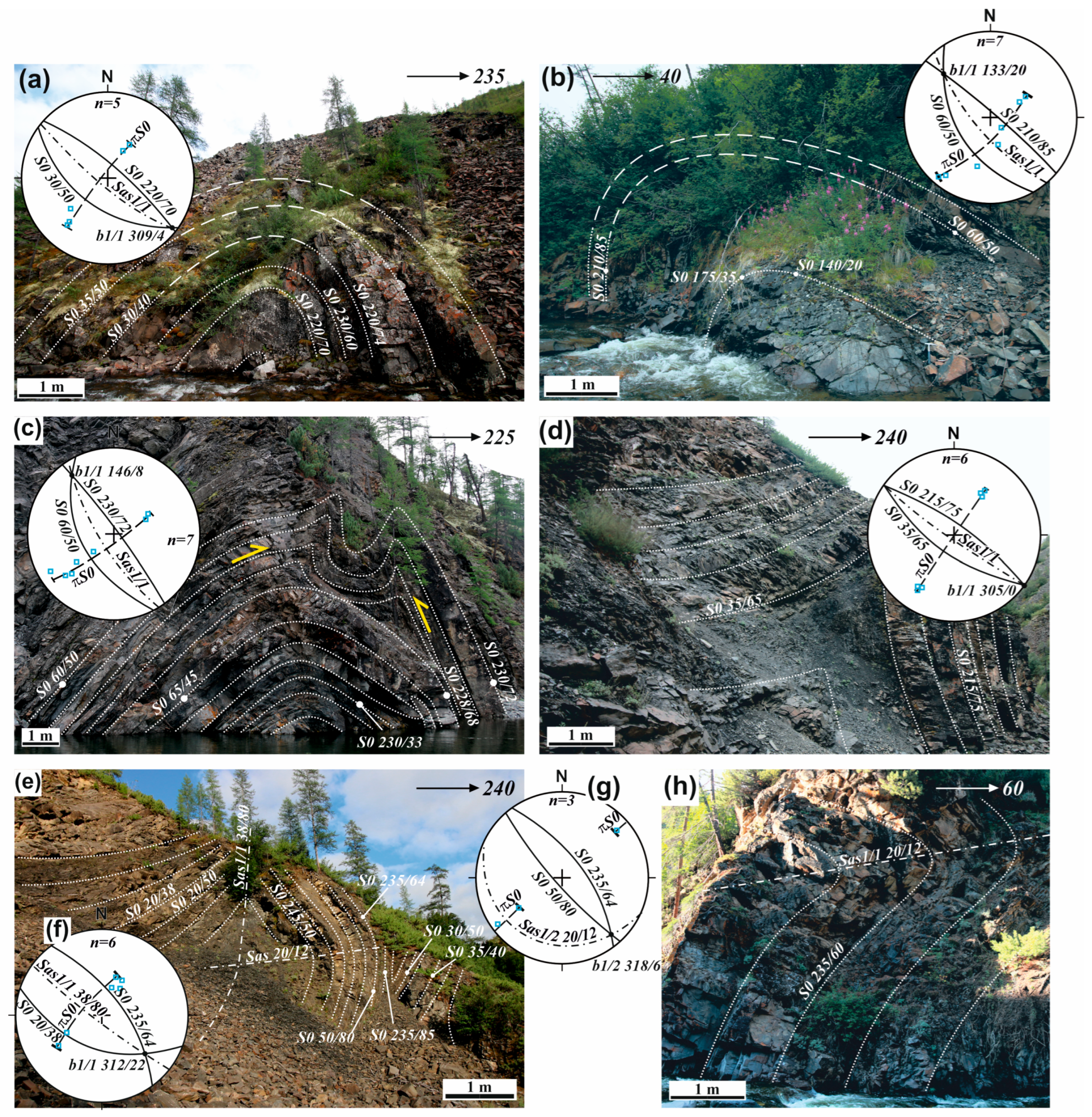
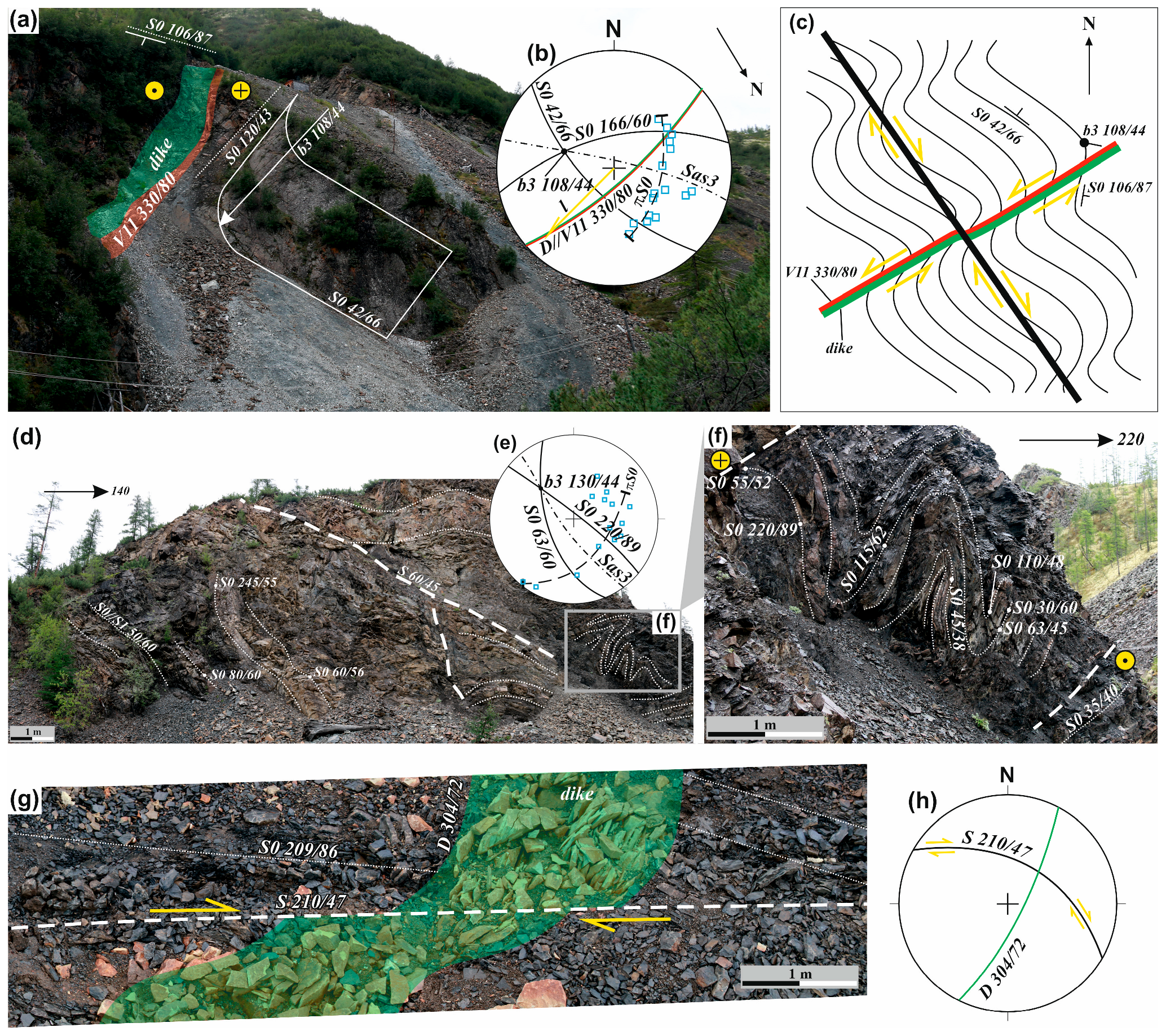
4.1.1. Vyun Gold Deposit

Ore bodies of the Vyun gold deposit are represented by gold–quartz veins and disseminated pyrite–arsenopyrite mineralization with “invisible” gold in the dike and the surrounding terrigenous rocks (Figure 4) [17,51]. Mineralization dominates in the dike and its contacts with sandstones and siltstones of the Nyakuninskaya formation of the Upper Triassic (Figure 5). The dike of trachyandesites and dacites has an east–northeast (60–70°) strike, a thickness of 2–5 m, a length of about 800 m [15]. The dike dips northwest and southeast at angles 47–80°. On the northeastern flank, quartz veins are removed from the dike by 30–40 m. The gold content in the veins is up to 190 g/t (average 8–14 g/t) [15].
Many deformation structures occur at the Vyun deposit. The most widespread are the early cylindrical symmetrical and asymmetric folds of the NW strike with gentle (b—4–14°) hinges and steep axial surfaces (Figure 6). Asymmetric anticlinal folds with long northeast and short southwest limbs are related to the southward direction of rock transport during J3-K1 accretion–collision events (D1 phase). There are folds with a round hinge (Figure 6a–c) and chevron folds with a sharp lock (Figure 6d,e). The visible fold width ranges between one and several hundred meters. It is platy, rarely shelly platy, and its intensity depends on the rock composition. The most intense cleavage is visible in siltstones, whereas in sandstones it becomes coarse-platy. Its regional NW strike changes in areas of superposed strike-slip deformation. Overturned recumbent folds with flat axial surfaces are also mapped (Sas 20/12) (Figure 6e,h). The superposition of these folds on the early folds occurred in a coaxial stress field, which is typical for progressive deformations (Figure 6e).
All above-mentioned and similar orientations of the folds suggest that the early fold–thrust structures (F1/1, S1/1, and F1/2) were formed under conditions of progressive deformation D1 (Figure 6). Such a possibility of the formation of complex folds during progressive deformation is described in [58,59].
Post-ore structures are related to strike-slip strains of D2–D3 phases, and normal faults of the D4 phase. Folds with steep hinges are commonly found along the dike walls and quartz vein of the Vyun deposit (Figure 7a,b). Z-type folds have hinges plunging to the ESE (b3—104/66 and 108/44) (Figure 7b,c). Asymmetric anticlines with long NE (S0 42–50/66–77) and short SE (S0 120–130/43–69) limbs are typical. The hinge of the fold is near perpendicular to the direction of the accretion slickenlines (l3 227/4) at the contact of the quartz vein V11 315/75 (Figure 5d, diagram). On the limbs of early folds in siltstones in sandstones, intraplate drag folds of NW strike can be observed (b3 130/44) (Figure 7d–f). Such folds were formed during reverse-dextral strike-slip displacements on the structures of the northwestern strike and reverse-sinistral strike-slip displacements by the faults of northeastern strike associated with them (Figure 7c). Dikes and faults of NE strike are also displaced by dextral post-ore strike-slip faults (Figure 7g,h).
The faults of the NW and NE strike prevail (Figure 3). Northwestern thrusts and reverse faults of predominantly SW vergence limit tectonic plates, within which there is a change in the intensity of deformations. The thrust faults are associated with steep NE faults—lateral ramps of the Bukeschen–Elgendzhinskaya system with dominant strike-slip kinematics. These faults determine the position of the Tithonian dikes and orogenic gold–quartz mineralization.
Quartz, quartz–carbonate, quartzchlorite–carbonate veins are common in the Vyun deposit and the Shumny area. They occur in dikes, on their contacts with host rocks, and in sandstones. Analysis of the attitude of quartz veins and veinlets revealed three variously oriented systems (Figure 4). Veins of the first system V11 have persistent parameters; they are conformable with the NE strike of the dikes (Figure 2 and Figure 8e). The veins V11 are the thickest and are extended and localized along the plane σ3/σ1. Quartz veins of the second system V12 are conformable with the bedding plane and thrust sheets, whereas veins of the third system V13 are orientated conformably with V12, but they dip in the opposite direction. Quartz veins of systems 2 and 3 s are thin (up to a few centimeters). Such systems of quartz vein mineralization, which are related to the reverse and thrust fault stress field, are also found at other gold deposits in the central part of the KNT (Bazovskoe, Malo-Tarynskoye, Khangalas, Badran, Levoberezhnoye, and Sana) [5,6,30,51,60,61,62]. The subvertical position of the plane σ3/σ1 indicates a reverse/thrust stress field during the formation of gold–quartz bodies of the Vyun area. The calculated values of the paleo stress fields are as follows: σ3—72/56; σ2—328/2; and σ1—235/34.

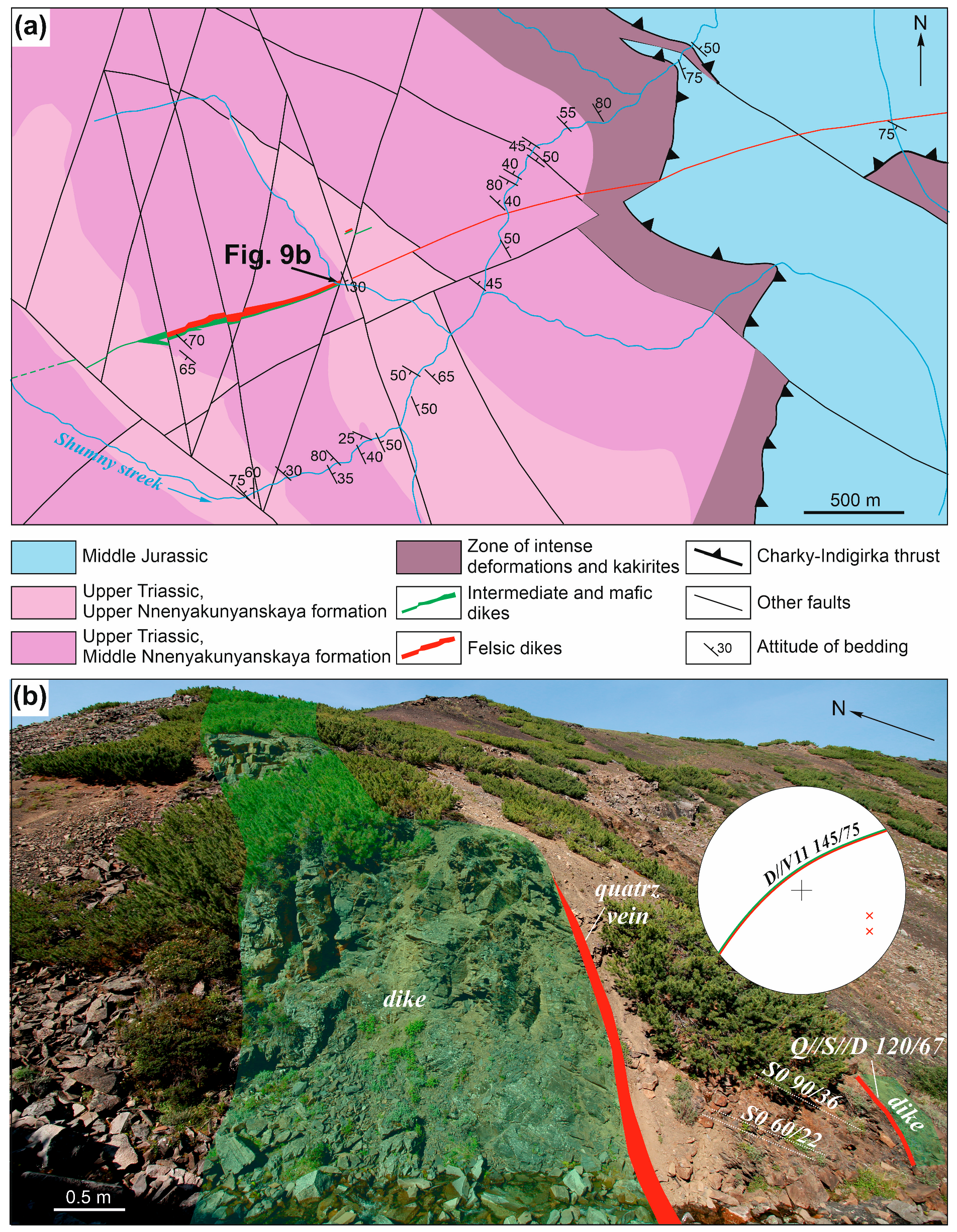
4.1.2. The Shumny Area

The Shumny area is dominated by the disseminated mineralization of pyrite in the dike of trachybasalts, trachyandesites, andesites, dacite, granodiorites, and sandstones. On the SW flank, the dike is basic to medium, acidic on the NE, and has a mixed composition in the center (Figure 9). The host rocks are sandstones and siltstones of the Middle–Upper Nyakunyinskaya formation of the Upper Triassic. The dike is subvertical to the ENE strike. At certain intervals, its occurrence changes to the NNW, probably due to late sinistral strike-slip faults. They also shift the dike to a distance of a few tens of meters (Figure 9). The apparent thickness of the dike is up to 30 m, and the length is about 4.5 km.
Features of the deformation structures of the Shumny area are determined by the proximity to the CHI, which separates the Triassic clastic deposits of the KNT from the Jurassic clastic deposits of the PDT. In the lower reaches of the Shumny creek, the axial part of the thrust and the zone of intense deformations with an apparent thickness of about 500 m are exposed (Figure 9a and Figure 10). In the thrust front, the Triassic terrigenous rocks are crushed into isoclinal and compressed folds F1/1 of the northwestern strike with gently sloping (4–12°) hinges (Figure 10b,c). Boudinage structures develop parallel to the hinges (L1/1 123/8 (Figure 10d), L1/1 320/8 (Figure 10f). Superimposed deformations are represented by Z-type folds (b 275/48), related to the dextral strike-slip faults (Figure 10e).
At a distance from the thrust, the deformation structures are identical to those described for the Vyun deposit. Open, cylindrical folds F1 of the NW strike occur here (Figure 11a–c). Overturned and compressed folds of the NW orientation also occur (Figure 11d,e). In the case of a late normal fault in combination with sinistral strike-slip movements on the faults of the NW strike and a normal fault in combination with dextral strike-slip movements on the NE faults (S 305/85), transverse folds F2 with a vertical axial surface Sas2 and a moderately steep hinge b2 are formed (Figure 11f).
On the left side of one of the right tributaries of the Shumny Creek, boudins and near-fault folds can be observed F3 (Figure 12). In the footwall of the intrastratal fault S//S0 45/55, a boudinaged (L3 87/46) dike with a thickness of about 3 m is exposed. In the proximal contact of the fault, the siltstones are crushed into a fold with a moderately steep hinge b 125/30. The Z-shaped morphology of the fold indicates reverse-dextral strike-slip kinematics of movements on the fault. A small boudin of the dike (L3 113/35 is identified in the hanging contact. The close position of the axes of the boudin dikes and the hinge of the fold indicates their syngenetic character.
The poles of quartz veins and veinlets of the Shumny area form three differently oriented systems, shown in diagrams (Figure 2l). Veins of the first system V11 have persistent parameters; they are conformable with the NE strike of dikes (Figure 9). V11 veins, also on the Shumny area, are the thickest, and are extended and localized along the plane σ3/σ1, parallel to the dikes (Figure 2l). Quartz veins of the second system V12 are conformable to the bedding plane and thrust sheets, and veins of the third system V13 are oriented conformably to V12, but they dip in the opposite direction. Quartz veins of V12 and V13 systems are thin (up to the first centimeters). They are also grouped along a vertical plane σ3/σ1, which indicates a reverse/thrust stress field during the formation of gold–quartz bodies with the following stress fields of stage D1: σ3—330/77; σ2—134/9; and σ1—45/2 (Figure 2i).

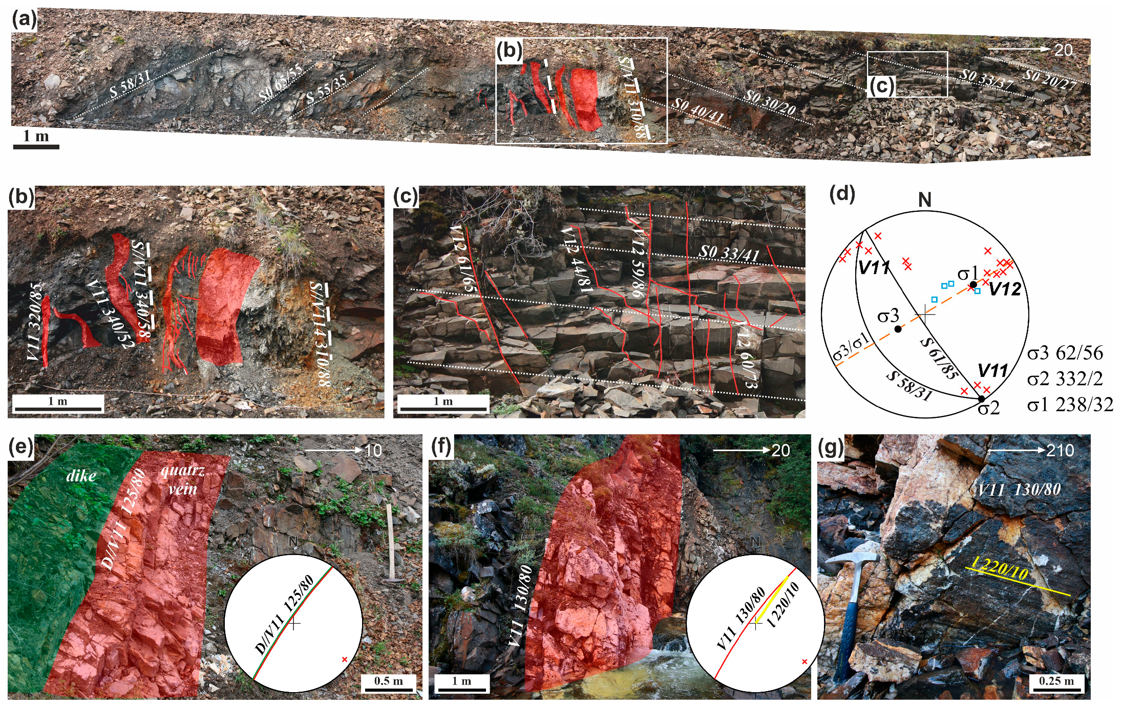
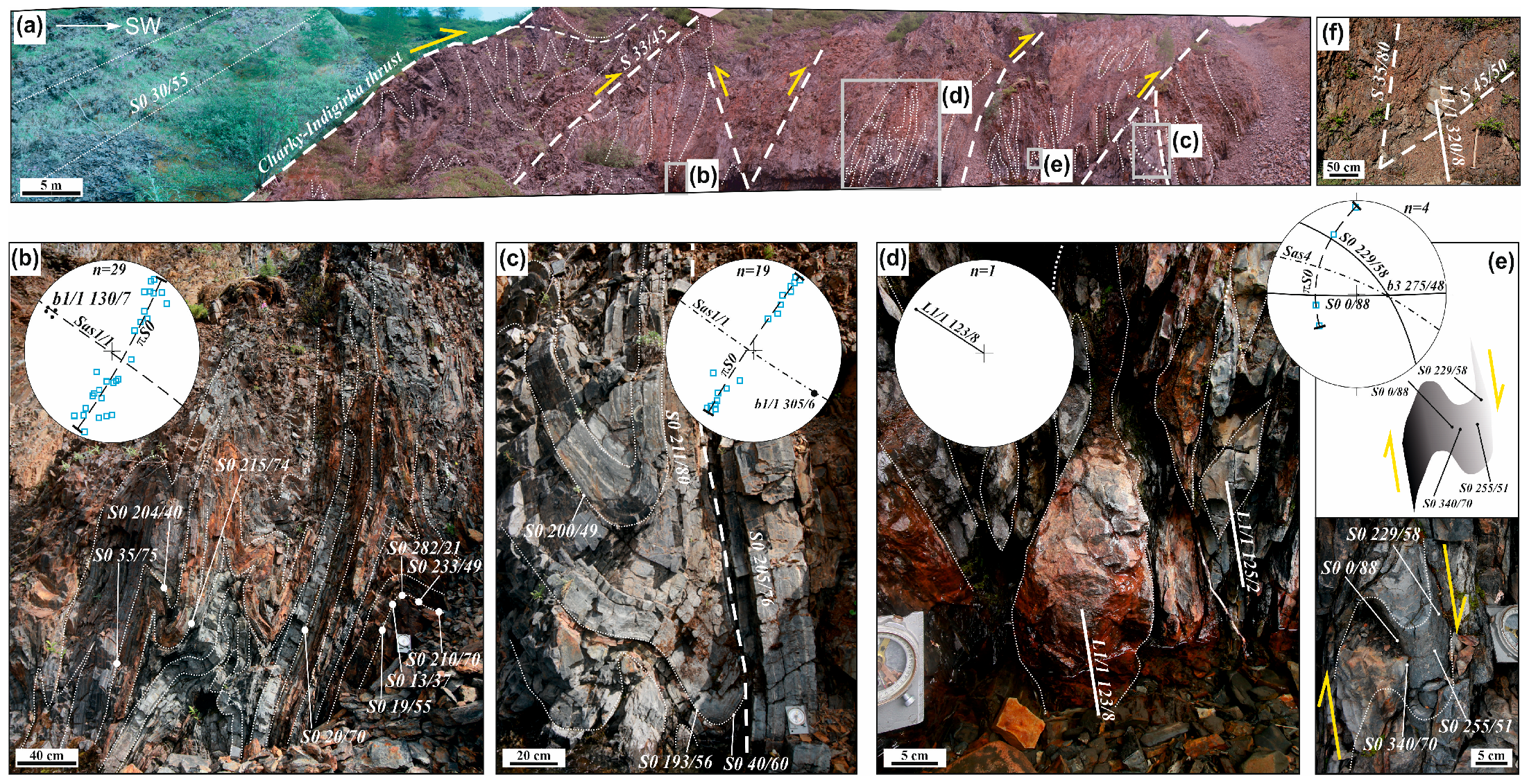
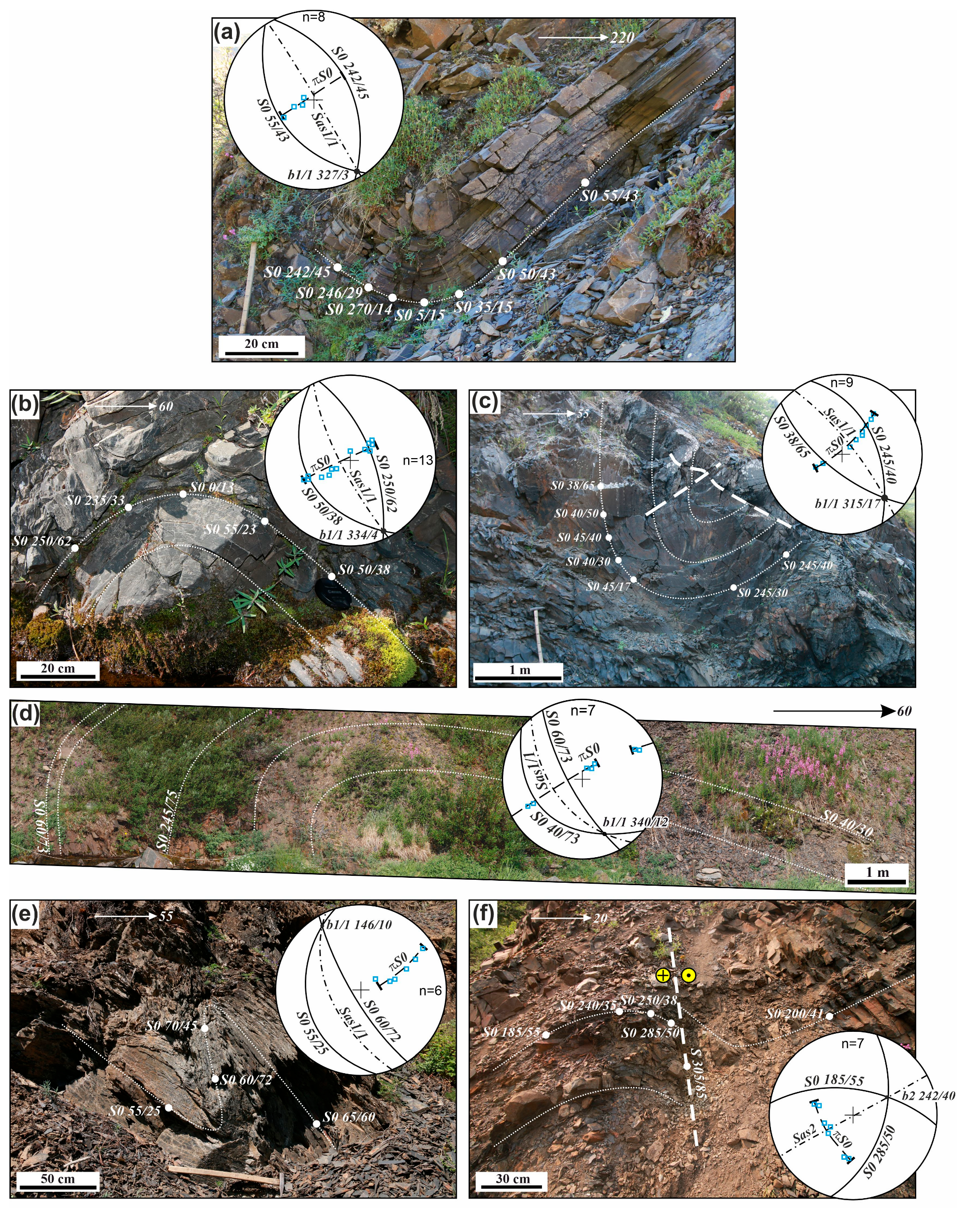
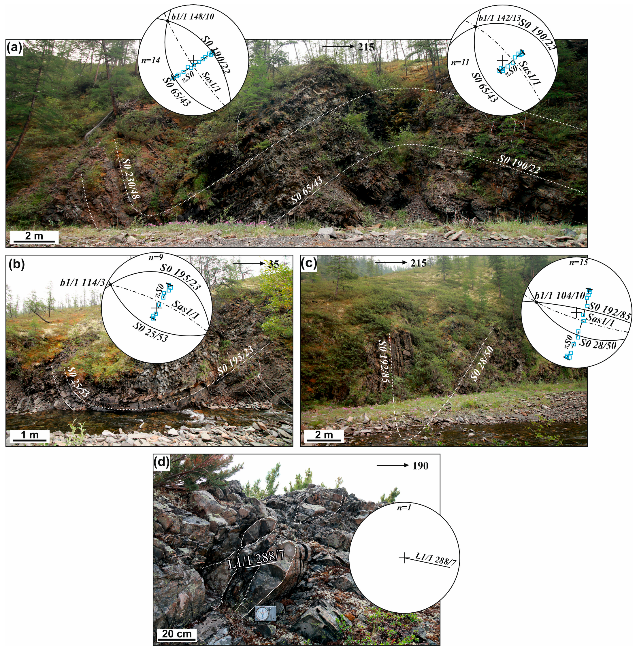
4.2. Structural Analysis of the Allochthon of the Charky–Indigirka Thrust

In the allochthon of the CHI (Polousno–Debin terrane), there are open, rarely compressed folds F1/1 with hinges b gently dipping to the SE (Figure 2 and Figure 13). They are morphologically close to the folds F1/1 visible in the paraautochthon (Figure 6 and Figure 11). F1/1 folds are accompanied by a boudinage, the axes of which are coaxial to the position of the hinges b1 (Figure 13d).
There are also F1/2 folds with gently sloping axial surfaces Sas1/2—68/35 (Figure 14a). Shear deformations D2 and D3 have not been detected, but they are assumed. The late fault structures of the stage are revealed D4 (Figure 14b,c). These are low-amplitude up to 4 m gently sloping faults of the submeridional strike S41 255/40 (Figure 14a,b). There are also systems of conjugated steep faults S42—295/63 and S43—145/66. Economically significant occurrences of gold mineralization in the allochthon have not been established.

5. Discussion

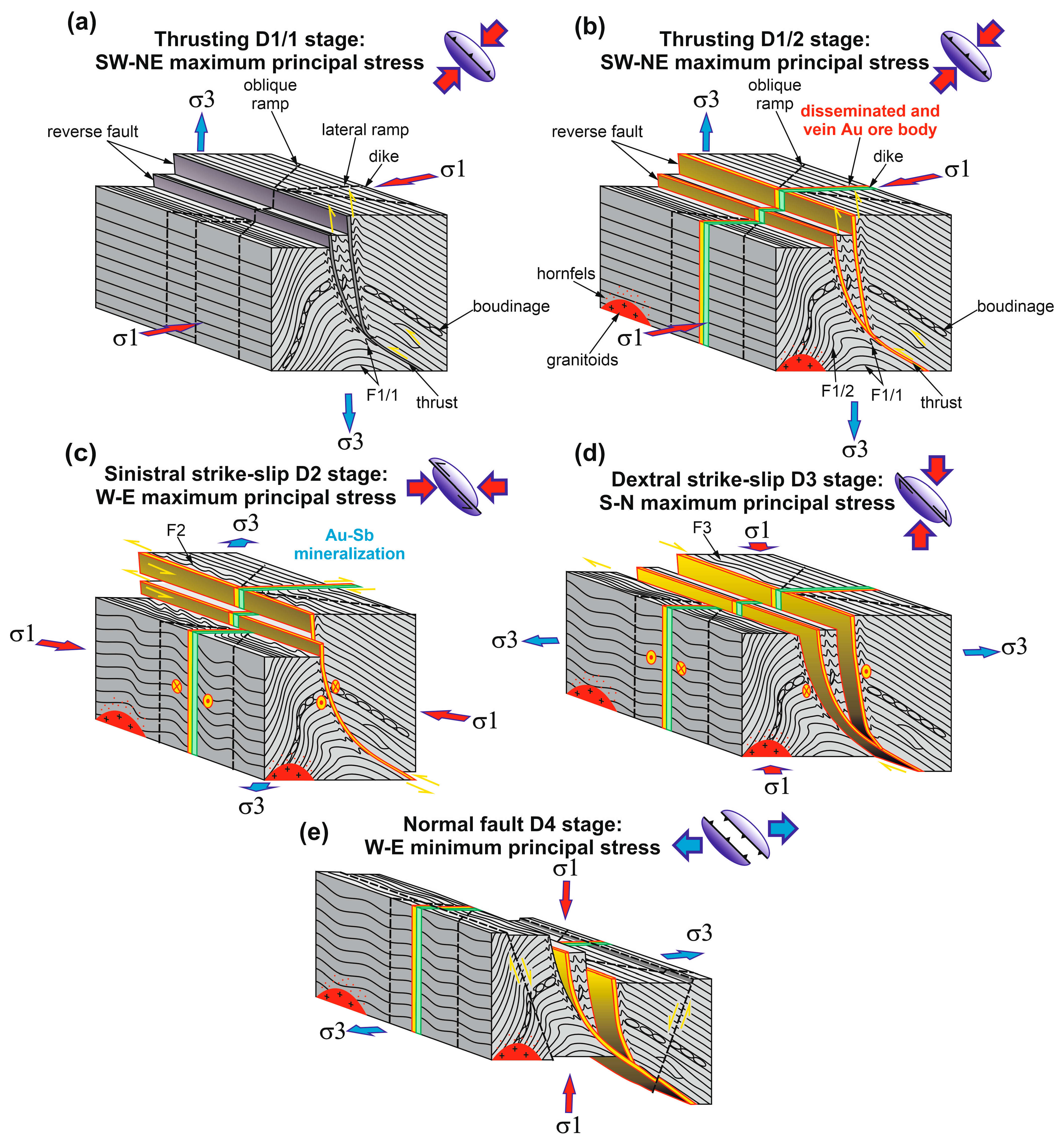
5.1. Style of Deformation, Space–Time Distribution, and Structural Control

The results of structural observations, as well as data [5,17,18,51], are summarized in Table 1, where the main deformation and mineralization events, magmatism, and metamorphism of the wall rock in the Vyun deposit and Shumny area are shown.

5.1.1. Pre-Mineralization

The strike of the early F1/1 folds and slope of their axial surfaces (Sas1/1), as well as the vergence, are interpreted to indicate an NE-SW compressional stress field D1 (Table 1, Figure 15a). At this stage, in the main regional faults (Adycha–Taryn and Charky–Indigirka), transverse and oblique ramps are formed. The hinges b1/1 of the early folds F1/1 are conformable to the hinges b1/2 of the superimposed overturned recumbent folds of the NW strike with gently sloping axial surfaces F1/2. Superimposition of F1/2 folds on the early F1/1 folds occurred in a coaxial stress field with an NE-SW compressional stress field. Such recumbent folds and those close to them in morphology have a regional distribution in the CHI front [5,17].
Field observations of the relationship of folds F1/1 and F1/2 and reliably dated dikes [17] and granitoid plutons [18] show that the folds were formed earlier (Figure 15). Dikes and granitoids were intruded at the beginning of the Berriasian–Tithonian (144.5–151 Ma) after the peak of metamorphism of the greenschist facies of the wall rock. Dike swarms and granitoid plutons form transverse northeast-trending series orthogonal to the main northwestern tectonic structures of central part of the YKOB and MKBB. Their position and localization in the extensional structures indicate an NE-SW compressional stress field during the formation of these magmatic complexes. Dike swarms of mafic rocks mark the relations between ore-forming fluid pathways and the deep lithosphere. However, no genetic link between dikes and mineralization is found. Considering this and the above-given structural data, we assume that the described fold–thrust deformation events D1 occurred no later than the Oxfordian at the turn of the Middle and Late Jurassic (~163.5 Ma). These deformations of the D1 phase developed under the conditions of a single continuous (non-stop) tectonic regime during frontal convergence of the KOS with the eastern margin of the Siberian Craton [17].
Overall, progressive pre-mineralization D1/1 and ore D1/2 compression in the NE-SW direction was the reason for the orientation of regional faults (Charky–Indigirka thrust and Adycha–Taryn fault) and folds F1/1 and F1/2, and the NE orientation of dike swarms and granitoid plutons of transverse series.

5.1.2. Mineralization

The transverse relationship between dikes and ore bodies determines the young age of mineralization. It is obvious, however, that dikes are favorable structures for fluid circulation and space for ore deposition. They are areas of heterogeneous stress and inhomogeneous strain [21]. Available ages of orogenic gold mineralization of the Yana–Kolyma belt (reviews in [2,4,25,48]) show that the peak of the formation of orogenic gold mineralization was later than the intrusion of the Late Jurassic dikes of trachybasalts, trachyandesites, dacites, and granitoids of the small intrusion complex [18]. The main Valanginian event of the formation of orogenic gold mineralization is assumed, which is later than the magmatism of the small intrusion complex by about 7–21 Ma and the Late Jurassic regional metamorphism. More specifically, Au mineralization is formed as a result of reactivation of pre-existing structures, which leads to the focusing of the ore fluid and determines the position of the deposits.
Structural analysis of the Au mineralization of the Vyun and Shumny area deposits shows the predominance of intersecting steeply dipping veins of the NW strike V11. Less often, gently sloping veins of the same type and steep veins of the same strike are observed. The formation of these veins is interpreted as related to NE-SW compressional stress at the end of the event D1/2. Such field stress is assumed for a mineralization event at other OGDs of the Upper-Indigirka sector of the YKOB [5,30]. In general, orogenic deposits hosted by second-order faults are subparallel to the (paleo-)suture zones of collision of the KOS and the eastern margin of the Siberian craton.

5.1.3. Post-Mineralization

Although there is no obvious Au-Sb mineralization at the Vyun and Shumny area deposits, it is assumed by the presence of rare small discoveries of stibnite. Similar mineralization is mainly localized to the NW and SE of the studied region, where there are large Au-Sb Sarylakh and Sentachan deposits located in the zone of the Adycha–Taryn fault [62]. Mineralization coincides with the formation of sinistral strike-slip faults of event D2, reactivating the NW regional fault systems, which were formed early in the tectonic history. Sinistral strike-slip faults at the Vyun deposit and Shumny area are confirmed by folds of S-type N-S and NW-SE (F2) with b2 dipping 40° to 80° and sinistral strike-slip accretionary slickenlines of the quartz hanging walls with horizontal slickenlines (l2) (Figure 5c). Such deformations are caused by an E-W compressional stress field. The later event of NW-SE dextral strike-slip faults is related to N-S maximum principal stress σ1 in the Vyun deposit and Shumny area (Table 1). The D3 event is related to the E-W folds of Z-type (F3) with b3 dipping 40° to 80° and horizontal slickenlines (l3) and boudinage (L3). Late dextral strike-slip faults have been described in other OGDs of the YKOB [62,63]. Normal fault deformations D4 are observed locally. The environment of regional W-E extension could be caused by the development of the Indigirka extension belt in the Paleocene and the opening of the Eurasian Oceanic basin in the Arctic [64].

5.2. Correlation Mineralization and Regional Deformation

Our results suggest that the Au mineralization of the Vyun deposit and Shumny area was associated with the D1/2 phase. It correlates with the SW regional transport in the Late Jurassic–Valanginian, which was related to the closure of the small Oymyakon paleo-ocean and the subsequent collision of the KOS and the eastern margin of the Siberian Craton [2,26]. The enrichment of the subcrustal lithospheric mantle (SLM) was crucial for the Late Jurassic–Early Cretaceous metallogeny during subduction of the Oymyakon Ocean slab (Figure 16). It is inferred that subduction involves slab steepening, break-off, or delamination of the lower continental lithosphere [65]. The participation of mantle sources in the magma formation of the preceding mineralization of the Vyun ore field is confirmed by the geochemical and isotopic composition of the igneous rocks of the transverse series [17,18]. These rocks were formed from a mixed source with the involvement of mantle (OIB- and E-MORB-type), lower crust, and subduction components, with Mesoproterozoic–Paleoproterozoic Sm-Nd model estimates of the age of their magmatic sources [17,18].
The subcrustal lithospheric mantle was fertilized in the time preceding mineralization and was derived directly from the down-going subduction slab and overlying sediment wedge at the closure of the Oymyakon Ocean [6]. OGDs were formed with the involvement of devolatilization of the earlier-fertilized mantle lithosphere with the collision of the KOS and the eastern margin of the Siberian Craton [6]. Mantle signatures of the isotopic composition of sulfur sulfides and native gold are typical for many OGDs in the region [6,49,51]. At the Vyun deposit, there are heterogeneous δ34S in the sulfides. The highest variations of δ34S are determined in Py from dikes (from −6.4 to +3.1‰, mean −1.9‰, median −3.3‰). The highest δ34S values are determined in Py (from +2.3 to +5.6‰, mean +4.0‰, median +4.1‰) and Apy (+4.4‰) from clastic rocks. Analyses of δ34S in Py from the alteration of the Shumny yielded positive values from +2.1 to +5.1‰. There are no evident isotopic variations between δ34S in Py from sandstones (from +4.3 to +5.0‰) or from dikes (from +2.1 to +5.1‰, mean +3.4‰, median +2.5‰). The slightly heavier sulfur isotopic composition of sulfides from the Shumny and Vyun intrusion-hosted deposits may indicate a mixture of subcrustal, metamorphic, partially magmatic, and sedimentary sources [51]. The metallogenic time of formation of the gold mineralization is synchronous with the tectonic event and likely reflects the final stages of the Kolyma–Omolon microcontinent–Siberian Craton collision in the Valanginian during crustal thickening [51] (Figure 16).
Our data demonstrate a combination of Mesozoic oceanic subduction and accretionary orogeny with continental collision and their relationship with gold metallogeny in the Yana–Kolyma orogen. Critical features and the spatial–temporal distribution of similar deposits are shown [23] using the example of the Cenozoic metallogeny of Tibet, formed during the continental collision of India–Eurasia.
Post-mineralization events are demonstrated by regional NW strike-slip faults. It was revealed that the lithosphere-scale strike-slip faults overlapped earlier thrust zones. The D2 event determined by the N-S stress field caused by the late Hauterivian–Aptian event was probably a reflection of superimposed tectonic thermal processes occurring in the rear of the Uda–Murgal volcanic–plutonic belt, which was associated with Paleo-Pacific subduction and the development of the Paleo-Arctic margin of Siberia [6]. The D3 tectonic event was determined by the subduction–accretion tectonic regime on the eastern continental margin of Siberia, which is related to the development of the Albian–late Cretaceous (~106–76 Ma) Okhotsk–Chukotka volcanic belt. Events D2 and D3 are associated with post-orogenic Au-Sb, Au-Ag, Ag-Sb, and Sn mineralization. The opening of the Eurasian ocean basin in the Arctic in the Paleocene caused the D4 tension strains.

6. Conclusions

Orogenic gold mineralization of the Vyun deposit and Shumny area is an excellent example of structural control of mineralization in collisional orogens on the margins of cratons. The main tectonic style of the structure is determined by longitudinal NW fold-rupture systems of the imbricated thrust type and transverse NE faults. The pre-mineralization deformations and metamorphic and magmatic events share a common NE-SW shortening (D1), which is related to the subduction of the Oymyakon oceanic slab and collision of the KOS with the eastern margin of the Siberian Craton. These deformations are characterized by a multiphase history of superposition of several tectonic events under compression conditions and progressive evolution of the host structures. Ore mineralization formed at the end of compression in the same stress field (D1). Its structural control represented reactivation of older dikes and faults, with the dikes representing areas of heterogenous stress favorable for the concentration of ore fluids and structural control of mineralization. The post-mineralization tectonic regime is related to the Aptian–Late Cretaceous tectonic transition from compression to transpression. Transpressional tectonics were determined accordingly by N-S (D2) and W-E (D3) stress fields caused by several accretionary events in the Cretaceous on the northern and eastern margins of Siberia. In the northern margin, it was driven by the collision of the Chukotka microcontinent with Siberian craton, and in eastern margin it was driven by continuous subduction of the Paleo-Pacific Plate.
A key role in the geological setting of the Vyun ore field is the involvement of the fertile subcrustal lithospheric mantle in the Late Jurassic–early Early Cretaceous collision in the Yana–Kolyma orogen. The probable trigger of Hauterivian–Valanginian metallogeny was upwelling of the asthenosphere or mantle flow along the transcrustal faults. The main impulse of Au-As mineralization coincided with the slowdown of convergence between the KOS and the eastern margin of the Siberian Craton. The obtained results demonstrate the relationship between gold metallogeny in the YKOB with Mesozoic oceanic subduction and continental collision, which contributes to the development of models of the formation of orogenic gold deposits.

Author Contributions

Conceptualization, V.Y.F.; methodology, V.Y.F. and M.V.K.; software, V.Y.F. and M.V.K.; validation, V.Y.F.; formal analysis, V.Y.F. and M.V.K.; investigation, V.Y.F.; resources, V.Y.F. and M.V.K.; data curation, V.Y.F.; writing—original draft preparation, V.Y.F. and M.V.K.; writing—review and editing, V.Y.F. and M.V.K.; visualization, M.V.K.; supervision, V.Y.F.; project administration, V.Y.F.; funding acquisition, V.Y.F. All authors have read and agreed to the published version of the manuscript.

Funding

This study was supported by the Diamond and Precious Metals Geology Institute, Siberian Branch of the Russian Academy of Sciences (FUFG-2024-0006; structural analysis), Russian Scientific Foundation (23-47-00064; geodynamic implications).

Data Availability Statement

The original contributions presented in this study are included in the article material. Further inquiries can be directed to the corresponding author.

Acknowledgments

The authors are grateful to the Yu.P. Sobyanin, for supporting the visit to the Vyun ore field.

Conflicts of Interest

The authors declare no conflicts of interest.

References

  1. Gamyanin, G.N. Mineralogical and Genetic Aspects of Gold Mineralization of Verkhoyansk-Kolyma Mesozoids; Nauka: Moscow, Russia, 2001; 222p. (In Russian) [Google Scholar]
  2. Goryachev, N.A.; Pirajno, F. Gold deposits and gold metallogeny of Far East Russia. Ore Geol. Rev. 2014, 59, 123–151. [Google Scholar] [CrossRef]
  3. Goldfarb, R.J.; Taylor, R.; Collins, G.; Goryachev, N.A.; Orlandini, O.F. Phanerozoic continental growth and gold metallogeny of Asia. Gondwana Res. 2014, 25, 49–102. [Google Scholar] [CrossRef]
  4. Voroshin, S.V.; Tyukova, E.E.; Newberry, R.J.; Layer, P.W. Orogenic gold and rare metal deposits of the Upper Kolyma District, Northeastern Russia: Relation to igneous rocks, timing, and metal assemblages. Ore Geol. Rev. 2014, 62, 1–24. [Google Scholar] [CrossRef]
  5. Fridovsky, V.Y. Structural control of orogenic gold deposits of the Verkhoyansk-Kolyma folded region, northeast Russia. Ore Geol. Rev. 2018, 103, 38–55. [Google Scholar] [CrossRef]
  6. Fridovsky, V.Y.; Polufuntikova, L.I.; Kryazhev, S.G.; Kudrin, M.V.; Anisimova, G.S. Geology, fluid inclusions, mineral and (S-O) isotope chemistry of the Badran orogenic Au deposit, Yana-Kolyma belt, Eastern Siberia: Implications for ore genesis. Front. Earth Sci. 2024, 12, 1340112. [Google Scholar] [CrossRef]
  7. Kudrin, M.V.; Fridovsky, V.Y.; Polufuntikova, L.I.; Kryazhev, S.G.; Kolova, E.E.; Tarasova, Y.A. The Khangalas Orogenic Au Deposit, Yana–Kolyma Metallogenic Belt (Northeast Russia): Structure, Ore Mineral and Isotopic (O, S, Re, Os, Pb, Ar, and He) Composition, Fluid Regime, and Formation Conditions. Geol. Ore Depos. 2024, 66, 484–511. [Google Scholar] [CrossRef]
  8. Gamyanin, G.N.; Goryachev, N.A.; Bakharev, A.G.; Kolesnichenko, P.P.; Zaitsev, A.I.; Diman, E.N.; Berdnikov, N.V. Conditions of Initiation and Evolution of Granitoid Gold–Magmatic Systems in Mesozoides of Northeast Asia; SVKNII DVO RAN: Magadan, Russia, 2003. (In Russian) [Google Scholar]
  9. Zaitsev, A.I.; Fridovsky, V.Y.; Kudrin, M.V. Granitoids of the Ergelyakh intrusion-related gold–bismuth deposit (Kular-Nera Slate Belt, Northeast Russia): Petrology, physicochemical parameters of formation, and ore potential. Minerals 2019, 9, 297. [Google Scholar] [CrossRef]
  10. Vikent’eva, O.V.; Prokofiev, V.Y.; Gamyanin, G.N.; Bortnikov, N.S.; Goryachev, N.A. Intrusion-related gold-bismuth deposits of North-East Russia: PTX parameters and sources of hydrothermal fluids. Ore Geol. Rev. 2018, 102, 240–259. [Google Scholar] [CrossRef]
  11. Hart, C.J.R.; McCoy, D.; Goldfarb, R.J.; Smith, M.; Roberts, P.; Hulstein, R.; Blake, A.A.; Bundtzen, T.K. Geology, exploration and discovery in the Tintina gold province, Alaska and Yukon. Soc. Econ. Geol. Spec. Publ. 2002, 9, 241–274. [Google Scholar]
  12. Ashley, P.M.; Craw, D. Structural controls on hydrothermal alteration and gold–antimony mineralisation in the Hillgrove area, NSW, Australia. Miner. Depos. 2004, 39, 223–239. [Google Scholar] [CrossRef]
  13. Jowitt, S.M.; Keays, R.R.; Jackson, P.G.; Hoggart, C.R.; Green, A.H. Mineralogical and geochemical controls on the formation of the Woods Point dike swarm, Victoria, Australia: Evidence from the Morning Star dike and implications for sourcing of Au within orogenic gold systems. Econ. Geol. 2012, 107, 251–273. [Google Scholar] [CrossRef]
  14. Volkov, A.V.; Prokofiev, V.Y.; Sidorov, A.A.; Goryachev, N.A. Gold deposits in the dikes of the Yana-Kolyma belt. Geol. Ore Depos. 2008, 50, 311–337. [Google Scholar] [CrossRef]
  15. Anisimova, G.S.; Protopopov, R.I. Geological structure and ore composition of the Vyun gold-quartz deposit, Eastern Yakutia. Ores Met. 2009, 5, 59–69. [Google Scholar]
  16. Pachersky, N.V.; Kryazhev, S.G.; Naumov, E.A.; Desyatova, D.Y.; Dvurechenskaya, S.S.; Samoilenko, M.V. New data on the reduced intrusion-related Au mineralization of Sentral Lolyma gold region: Age, formation conditions, composition, ore-controlling factors. Ores Met. 2021, 2, 68–89. (In Russian) [Google Scholar] [CrossRef]
  17. Fridovsky, V.Y.; Yakovleva, K.Y.; Vernikovskaya, A.E.; Vernikovsky, V.A.; Matushkin, N.Y.; Kadilnikov, P.I.; Rodionov, N.V. Geodynamic emplacement setting of Late Jurassic dikes of the Yana–Kolyma Gold Belt, NE folded framing of the Siberian Craton: Geochemical, petrologic, and U–Pb zircon data. Minerals 2020, 10, 1000. [Google Scholar] [CrossRef]
  18. Fridovsky, V.Y.; Vernikovskaya, A.E.; Yakovleva, K.Y.; Rodionov, N.V.; Travin, A.V.; Matushkin, N.Y.; Kadilnikov, P.I. Geodynamic formation conditions and age of granitoids from small intrusions in the west of the Yana–Kolyma gold belt (Northeast Asia). Russ. Geol. Geophys. 2022, 63, 483–502. [Google Scholar] [CrossRef]
  19. Goldfarb, R.J.; Baker, T.; Dube, B.; Groves, D.I.; Hart, C.J.R.; Gosselin, P. Distribution, character, and genesis of gold deposits in metamorphic terranes. In Economic Geology One Hundredth Anniversary Volume; Hedenquist, J.W., Thompson, J.F.H., Goldfarb, R.J., Richards, J.P., Eds.; Society of Economic Geologists: Littleton, CO, USA, 2005; pp. 407–450. [Google Scholar] [CrossRef]
  20. Goldfarb, R.; Groves, D. Orogenic gold: Common or evolving fluid and metal sources through time. Lithos 2015, 233, 2–26. [Google Scholar] [CrossRef]
  21. Groves, D.I.; Santosh, M.; Deng, J.; Wang, Q.; Yang, L.; Zhang, L. A holistic model for the origin of orogenic gold deposits and its implications for exploration. Miner. Depos. 2018, 55, 275–292. [Google Scholar] [CrossRef]
  22. Deng, J.; Wang, Q.F.; Santosh, M.; Liu, X.F.; Liang, Y.Y.; Zhao, R.; Yang, L. Remobilization of metasomatized mantle lithosphere: A new model for the Jiaodong gold province, eastern China. Min. Dep. 2020, 55, 257–274. [Google Scholar] [CrossRef]
  23. Yang, L.; Wang, Q.; Groves, D.I.; Lu, S.; Li, H.; Wang, P.; Deng, J. Multiple orogenic gold mineralization events in a collisional orogen: Insights from an extruded terrane along the southeastern margin of the Tibetan Plateau. J. Struct. Geol. 2021, 147, 104333. [Google Scholar] [CrossRef]
  24. Zhao, H.; Wang, Q.; Groves, D.I.; Santosh, M.; Zhang, J.; Fan, T. Genesis of orogenic gold systems in the Daduhe belt: Evidence of long-lived fertile mantle lithosphere as a source of diverse metallogeny on the western margin of the Yangtze Craton, China. Ore Geol. Rev. 2022, 145, 104861. [Google Scholar] [CrossRef]
  25. Parfenov, L.M.; Kuz’min, M.I. Tectonics, Geodynamics and Metallogeny of the Territory of the Republic of Sakha (Yakutia); Nauka/Interperiodika: Moscow, Russia, 2001; p. 571. (In Russian) [Google Scholar]
  26. Khanchuk, A.I. Geodynamics, Magmatism, and Metallogeny of Eastern Russia; Dal’nauka: Vladivostok, Russia, 2006; p. 527. (In Russian) [Google Scholar]
  27. Nokleberg, W.J.; Parfenov, L.M.; Norton, I.O.; Khanchuk, A.I.; Stone, D.B.; Scholl, D.W.; Fujita, K. Phanerozoic Tectonic Evolution of the Circum-North Pacific; US Geological Survey, Professional Papers: Denver, CO, USA, 2001; Volume 1626, p. 123. [Google Scholar]
  28. Sokolov, S.D.; Tuchkova, M.I.; Ledneva, G.V.; Luchitskaya, M.V.; Ganelin, A.V.; Vatrushkina, E.V.; Moiseev, A.V. Tectonic position of the South Anyui Suture. Geotectonics 2021, 5, 51–72. [Google Scholar] [CrossRef]
  29. Fridovsky, V.Y.; Kudrin, M.V.; Polufuntikova, L.I.; Goryachev, N.A. Ore-controlling thrust faults at the Bazovskoe gold-ore deposit (Eastern Yakutia). Dokl. Earth Sci. 2017, 474, 617–619. [Google Scholar] [CrossRef]
  30. Fridovsky, V.Y.; Goryachev, N.A.; Krymsky, R.S.; Kudrin, M.V.; Belyatsky, B.V.; Sergeev, S.A. The Age of gold mineralization in the Yana–Kolyma metallogenic belt, Northeastern Russia: First data of Re–Os isotope geochronology of native gold. Russ. J. Pac. Geol. 2021, 15, 293–306. [Google Scholar] [CrossRef]
  31. Zonenshain, L.P.; Kuzmin, M.I.; Natapov, L.M. Tectonics of Lithospheric Plates of the USSR Territory; Nedra: Moscow, Russia, 1990; Volume 1, 327p. [Google Scholar]
  32. Arkhipov, Y.V.; Volkodav, I.G.; Kamaletdinov, V.A.; Yan-Zhin-Shin, V.A. Thrusts of the western part of the Verkhoyansk-Chukotka folded region. Geotectonics 1981, 2, 81–98. [Google Scholar]
  33. Konstantinovsky, A.A. Structure and geodynamics of the Verkhoyansk Fold-Thrust Belt. Geotectonics 2007, 41, 337–354. [Google Scholar] [CrossRef]
  34. Parfenov, L.M.; Badarch, G.; Berzin, N.A.; Khanchuk, A.I.; Kuzmin, M.I.; Nokleberg, W.J.; Prokopiev, A.V.; Ogasawara, M.; Yan, H. Summary of Northeast Asia geodynamics and tectonics. Stephan Mueller Spec. Publ. Ser. 2009, 4, 11–33. [Google Scholar] [CrossRef]
  35. Tsygankov, A.A.; Burmakina, G.N.; Khubanov, V.B. Sources of granitoid magmas in the southern part of the Main Batholith Belt (Northeast Asia): New geochemical and Sm-Nd isotope data. In Proceedings of the Geology and mineral resources of the North-East of Russia, Yakutsk, Russia, 30 March 2022. [Google Scholar]
  36. Protopopov, G.K.; Trushchelev, A.M.; Kuznetsov, Y.V. State Geological Map of the Russian Federation at a Scale of 1:1000000. Third Generation. Verkhoyansk-Kolyma Series. Sheet Q-54—Ust-Nera. Explanatory Note; Publishing House VSEGEI: St. Petersburg, Russia, 2019; 2019845p. [Google Scholar]
  37. Akinin, V.V.; Prokopiev, A.V.; Toro, J.; Miller, E.L.; Wooden, J.; Goryachev, N.A.; Alshevsky, A.V.; Bakharev, A.G.; Trunilina, V.A. U–PB SHRIMP ages of granitoids from the Main batholith belt (North East Asia). Dokl. Earth Sci. 2009, 426, 216–221. [Google Scholar] [CrossRef]
  38. Gertseva, M.V.; Luchitskaya, M.V.; Sysoev, I.V.; Sokolov, S.D. Stages of formation of the main batholith belt in the Northeast of Russia: U–Th–Pb SIMS and Ar–Ar geochronological data. Dokl. Akad. Nauk. 2021, 499, 5–10. [Google Scholar] [CrossRef]
  39. Layer, P.W.; Newberry, R.; Fujita, K.; Parfenov, L.; Trunilina, V.; Bakharev, A. Tectonic setting of the plutonic belts of Yakutia, northeast Russia, based on 40Ar/39Ar geochronology and trace element geochemistry. Geology 2001, 29, 167–170. [Google Scholar] [CrossRef]
  40. Shkodzinsky, V.S.; Nedosekin, Y.D.; Surnin, A.A. Petrology of Late Mesozoic Igneous Rocks of Eastern Yakutia; Nauka: Novosibirsk, Russia, 1992; 237p. [Google Scholar]
  41. Trunilina, V.A.; Roev, S.P.; Orlov, Y.S.; Oksman, V.S. Magmatism in Various Geodynamic Settings (the Junction Zone of the Verkhoyansk Margin of the Siberian Continent and the Kolyma-Omolon Microcontinent); YANTS SB RAS: Yakutsk, Russia, 1999; 151p. [Google Scholar]
  42. Trunilina, V.A.; Orlov, Y.S.; Roev, S.P. Magmatic associations of the Uyandino-Yasachnensky volcano-plutonic belt and its geodynamic nature. Dom. Geol. 2004, 5, 53–56. [Google Scholar]
  43. Toro, J.; Miller, E.L.; Prokopiev, A.V.; Zhang, X.; Veselovskiy, R. Mesozoic orogens of the Arctic from Novaya Zemlya to Alaska. J. Geol. Soc. 2016, 173, 989–1006. [Google Scholar] [CrossRef]
  44. Ganelin, A.V.; Luchitskaya, M.V.; Maskaev, M.V. U–Th–Pb (SIMS) Age and formation conditions of volcanic rocks of the Indigir section of the Uyandi-Yasachne volcanic belt (Northeast Asia). Rep. Russ. Acad. Sci. Earth Sci. 2021, 496, 11–16. [Google Scholar] [CrossRef]
  45. Stavsky, A.P.; Gedko, M.I.; Danilov, V.G. Uyandino-Yasachaya Island Arc: Geological Mapping of Volcano-Plutonic Belts; Roskomnedra, Geokart, MANPO: Moscow, Russia, 1994; pp. 265–296. [Google Scholar]
  46. Gedko, M.I. Uyandino-Yasachenskaya Late Jurassic Island Arc (North-East of Russia). Geotectonics 1988, 3, 153–165. [Google Scholar]
  47. Nokleberg, W.J.; Bundtzen, T.K.; Eremin, R.A.; Ratkin, V.V.; Dawson, K.M.; Shpikerman, V.I.; Goryachev, N.A.; Byalobzhesky, S.G.; Frolov, Y.F.; Khanchuk, A.I.; et al. Metallogenesis and Tectonics of the Russian Far East, Alaska, and the Canadian Cordillera; USGS Professional Paper: Reston, VA, USA, 2005; Volume 1697. [Google Scholar]
  48. Akinin, V.V.; Alshevsky, A.V.; Polzunenkov, G.O.; Sergeev, S.A.; Sidorov, V.A. The age of Natalka orogenic gold deposit (U-Pb, 40Ar/39Ar, Re-Os constrain). Russ. J. Pac. Geol. 2023, 17, 570–585. [Google Scholar] [CrossRef]
  49. Obolensky, A.A.; Gushchina, L.V.; Anisimova, G.S.; Serkebaeva, E.S.; Tomilenko, A.A.; Gibsher, N.A. Physicochemical modeling of mineral formation processes at the Badran gold deposit (Yakutia). Russ. Geol. Geophys. 2011, 52, 290–306. [Google Scholar] [CrossRef]
  50. Goryachev, N.A.; Goryachev, I.N.; Sotskaya, O.T.; Mikhalitsyna, T.I. The early cretaceous mineralization of the northern Priokhotye (Magadan region, Russia). Russ. J. of Pac. Geol. 2023, 42, 118–130. (In Russian) [Google Scholar] [CrossRef]
  51. Fridovsky, V.Y.; Polufuntikova, L.I.; Kudrin, M.V. Origin of disseminated gold-sulfide mineralization from proximal alteration in orogenic gold deposits in the central sector of the Yana–Kolyma metallogenic belt, NE Russia. Minerals 2023, 13, 394. [Google Scholar] [CrossRef]
  52. Goldfarb, R.J.; Groves, D.I.; Gardoll, S. Orogenic gold and geologic time: A synthesis. Ore Geol. Rev. 2001, 18, 1–75. [Google Scholar] [CrossRef]
  53. Kudrin, M.V.; Fridovsky, V.Y.; Polufuntikova, L.I.; Kryuchkova, L.Y. Disseminated Gold–Sulfide Mineralization in Metasomatites of the Khangalas Deposit, Yana–Kolyma Metallogenic Belt (Northeast Russia): Analysis of the Texture, Geochemistry, and S Isotopic Composition of Pyrite and Arsenopyrite. Minerals 2021, 11, 403. [Google Scholar] [CrossRef]
  54. Gzovsky, M.V. Principles of Tectonophysics; Nauka: Moscow, Russia, 1975; 536p. (In Russian) [Google Scholar]
  55. Sherman, S.I.; Dneprovsky, Y.I. Stress Fields in the Earth’s Crust and Geological-Structural Methods of their Study; Nauka: Novosibirsk, Russia, 1989; 157p. [Google Scholar]
  56. Ramsay, J.G.; Huber, M.I. Modern Structural Geology, Folds and Fractures; Academic Press: London, UK, 1987; pp. 309–700. [Google Scholar]
  57. Price, N.J.; Cosgrove, J.W. Analysis of Geological Structures. Cambridge University Press: Cambridge, UK, 1990. [Google Scholar]
  58. Fossen, H. Structural Geology; Cambridge University Press: Cambridge, UK, 2010; p. 463. [Google Scholar]
  59. Fossen, H.; Cavalcante, G.C.G.; Pinheiro, R.V.L.; Archanjo, C.J. Deformation–progressive or multiphase? J. Struct. Geol. 2019, 125, 82–99. [Google Scholar] [CrossRef]
  60. Fridovsky, V.Y. Analysis of deformation structures of the Elga ore cluster (Eastern Yakutia). Domest. Geol. 2010, 4, 39–45. [Google Scholar]
  61. Fridovsky, V.Y.; Gamyanin, G.N.; Polufuntikova, L.I. Dora-Pil ore field: Structure, mineralogy, and geochemistry of mineral formation environment. Ores Met. 2012, 5, 7–21. [Google Scholar]
  62. Fridovsky, V.Y.; Gamyanin, G.N.; Polufuntikova, L.I. The Sana Au–quartz deposit within the Taryn ore cluster. Razved. Okhrana Nedr 2013, 2, 3–7. (In Russian) [Google Scholar]
  63. Bortnikov, N.S.; Gamyanin, G.N.; Vikent’eva, O.V.; Prokofiev, V.Y.; Prokopyev, A.V. Gold-antimony deposits Sarylakh and Sentachan (Sakha-Yakutia): An example of the combination of mesothermal gold-quartz and epithermal stibnite ores. Geol. of Ore Depos. 2010, 52, 381–417. [Google Scholar] [CrossRef]
  64. Pavlovskaia, E.A.; Khudoley, A.K.; Ruh, J.B.; Moskalenko, A.N.; Guillong, M.; Malyshev, S.V. Tectonic evolution of the northern Verkhoyansk fold-and-thrust belt: Insights from palaeostress analysis and U–Pb calcite dating. Geol. Mag. 2022, 159, 2132–2156. [Google Scholar] [CrossRef]
  65. Akinin, V.V.; Miller, E.L.; Toro, J.; Prokopiev, A.V.; Gottlie, E.S.; Pearcey, S.; Polzunenkov, G.O.; Trunilina, V.A. Episodicity and the dance of late Mesozoic magmatism and deformation along the northern circum-Pacific margin: North-eastern Russia to the Cordillera. Earth-Sci. Rev. 2020, 208, 103272. [Google Scholar] [CrossRef]
Figure 3. Characteristics of vein-style (ac) and disseminated-style (gi,mo) ores of the Vyun deposit and Shumny area (reflected-light photomicrographs showing mineral assemblages of the vein- (df) and disseminated-style (jl,pr) ores). (a) Coarse-banded texture of quartz with arsenopyrite-2 dissemination; (b) quartz containing galena and chalcopyrite; (c) quartz vein of veinlet structure containing pyrite-3 and arsenopyrite-1; (d) myrmekitic and oval particles of native gold in pyrite, associated with arsenopyrite and galena; (e) replacement of cataclastic arsenopyrite crystals with native gold, chalcopyrite, galena, and sphalerite in quartz; (f) native gold with inclusions and in growth with chalcopyrite, with galena, sphalerite, and burnonite in quartz. The visible gold appears to be paragenetically late; (g) quartz veinlets with arsenopyrite-1 and pyrite-3; (h) veinlet-disseminated mineralization in siltstone, caused by spherulitic and layered accumulations of diagenetic pyrite-1 and thin metamorphogenic pyrite–quartz veinlets with pyrite-2; (i) metasomatic veinlet-disseminated mineralization with pyrite-3 and quartz; (j,k) disseminations of pyrite-3 and arsenopyrite 1 in sandstone; (l) the metasedimentary rock is sericite–pyrite-altered rock; (mo) disseminated sulfide mineralization with metacrystals of pyrite-3 and arsenopyrite-1 in dikes of trachyandesite (m,n) and andesite (o); (p) dissemination of pyrite-3 and arsenopyrite-1: pentagondodecahedral shape and zoning are characteristic of individual large pyrite crystals; (q) rod-like rims of quartz–carbonate composition; (r) dissemination of pyrite-3 and arsenopyrite-1 in the alteration of dikes. Abbreviation: quartz—Qz; sericite—Ser; native gold—Au; arsenopyrite—Apy; pyrite—Py; galena—Gn; chalcopyrite—Ccp; sphalerite—Sp; bournonite—Bn.
Geosciences 15 00168 g003
Figure 4. (a) Geological sketch map showing structure, dike position, stratigraphic divisions, and gold ore bodies; (b) schematic E–S-trending section from A to B across the Vyun deposit (modified from [15] and our field observations).
Geosciences 15 00168 g004
Figure 5. Photographs showing the relationship and structures of gold veins and the trachyandesite dike in the Vyun deposit (a); (b) concordant orientation Au orebody (V11), red line and dike (D), green line; (c) sinistral strike-slip accretionary slickenlines l3 of the quartz hanging walls. Arrows show the direction of displacement of the quartz hanging walls. Enlargement of post-ore fault plane and steps of quartz slickensides indicate sinistral strike-slip movement; (d) yellow line/arrow—projections of slickenlines l3 of the quartz hanging walls.
Geosciences 15 00168 g005
Figure 6. Photographs showing the folds from the Vyun gold deposit. (af) F1/1 folds with rounded (ac) and sharp (d,e) hinges and steep axial surfaces Sas1/1 and diagrams of bedding poles; (g,h) recumbent fold F1/2 with a gently sloping axial surface Sas1/2 and diagram of bedding poles.
Geosciences 15 00168 g006
Figure 7. Photographs showing the structural styles of post-ore deformation from the Vyun gold deposit. (a,b) Z-type folds related to reverse-dextral strike-slip movements on the northwestern faults. Yellow circles with “.” and “+” symbols within them—sinistral strike-slip movements; (c) Z-type fold formation model; (df) inclined intraplate drag folds and diagram of bedding poles in the northeastern limb of the anticline. Yellow circles with “+” and “.” symbols within them—dextral strike-slip movements; and (g,h) dextral strike-slip displacement of the dike.
Geosciences 15 00168 g007
Figure 8. Photographs showing the morphology of quartz veins from the Vyun gold deposit. (a) Quartz veins localized in the NW fault; the labels of images (b,c) show the photo locations in bottom row; (d) diagram of the poles of quartz veins shown in (ac). See Figure 2 for explanations of the symbols; (e) vein of the first system V11 is conformable with the NE strike of the dikes; (f) quartz veins of the NE strike; and (g) sinistral strike-slip accretionary slickenlines of the quartz walls. Arrows show the direction of displacement of the quartz hanging walls.
Geosciences 15 00168 g008
Figure 9. Geological sketch map showing structure (a) (modified after internal company data and our field observations). Photographs of dike (D) and Au–quartz vein (V11) (b), Shumny area. See Figure 5 for explanations of the symbols/colors.
Geosciences 15 00168 g009
Figure 10. Photographs showing the deformation styles of the Charky–Indigirka thrust from the Shumny area (section view). (a) Tectonic contact along the gently dipping ore–ore fault of the Middle Jurassic clastic deposits of the Polousno–Debin terrane and the Triassic clastic deposits of the Kular–Nera terrane. The labels of images (be) show the photo locations in bottom row; (b,c) isoclinal folds F1/1 of the NW strike and diagrams of bedding poles; (d) boudinage structures with L1/1 axes coaxial to the position of the hinges of the isoclinal folds F1/1 and diagram of the position of the boudin axis L1/1; (e) post-ore Z-type folds and diagram of bedding poles; and (f) boudinage structures L1/1.
Geosciences 15 00168 g010
Figure 11. Photographs showing the folds from the Shumny area. (ac) Northwest normal folds with steep axial surfaces Sas1/1 and diagram of bedding poles; (d,e) overturned folds F1/1 with moderately steep axial surfaces Sas1/1 and diagram of bedding poles; (f) transverse fold F2 with vertical axial surface Sas2 and a moderately steep hinge b2, associated with a normal fault in combination with dextral strike-slip movements on NE faults and a normal fault in combination with sinistral strike-slip movements on the NW faults and diagram of bedding poles. Yellow circles with “+” and “.” symbols within them—dextral strike-slip fault.
Geosciences 15 00168 g011
Figure 12. Photograph (a), kinematic scheme (b), and diagram of bedding poles (c) showing relations of boudins of dikes, folds, and the intraplate fault from the Shumny area. Green dots with lines—boudin axes. Yellow circles with “+” and “.” symbols within them—dextral strike-slip fault.
Geosciences 15 00168 g012
Figure 13. Photographs showing the deformation styles of the allochthon of the Charky–Indigirka thrust from the Shumny area (section view): (ac) northwest folds with steep axial surfaces Sas1/1 and near-horizontal hinges b1/1 and diagram of bedding poles; and (d) boudinage L1/1 coaxial to hinges b1/1 104–114/3–10.
Geosciences 15 00168 g013
Figure 14. Photographs showing the deformations in the allochthon of the Charky–Indigirka thrust: (a) recumbent fold F1/1 and diagram of bedding poles; (b) gently sloping normal faults S41; and (c) conjugated system of steeply dipping normal faults S42 and S43.
Geosciences 15 00168 g014
Figure 15. Schematic diagrams illustrating the geologic history and structural setting for the Vyun deposit and Shumny area, Yana–Kolyma orogen, Eastern Siberia. (a) NE-SW compressional stress field (D1/1) prior to mineralization formed folds F1/1, F1/2, NW regional faults S1, and metamorphism; (b) magmatism, reactivation of older faults, and resulting Au mineralization are related to the NE-SW compressional stress field (D1/2); (c) the post-ore E-W compressional stress field (D2) is related to S2 sinistral strike-slip faults and S-folds F2; (d) the N-S maximum compressional stress field (D3) is related to the dextral strike-slip fault S3 and Z-folds F3; and (e) extension event (D4) and normal fault S4.
Geosciences 15 00168 g015
Figure 16. A schematic model illustrating the geodynamic situation in the Tithonian–Valanginian and the structural position of the OGD of the Yana–Kolyma orogenic belt according to [18], with changes and additions. OGDs were formed with the involvement of devolatilization of the earlier-fertilized mantle lithosphere with frontal collision of the Kolyma–Omolon superterrane and the eastern margin of the Siberian Craton. Faults: AT—Adycha–Taryn; CHI—Charky–Indigirka; Chb—Chibagalakh.
Geosciences 15 00168 g016
Table 1. Recap of structures, magmatism, mineralization, and deformation events in the Vyun deposit and Shumny area of the Yana–Kolyma orogenic field.
FeaturesDeformation Events
D1D2D3D4
StructuresNW-SE folds (F1/1) with a steep axial surface Sas1/1 and b1/1 dipping 0° to 10°; S1: interlayer decollements, intrastratal ramps, NW thrusts, transverse and oblique ramps, cleavage of the fault, boudinage (L1/1); slickenlines downdip the rocks (l1); N-W folds F1/2 b with gently dipping axial surface Sas1/2 and b1/2 dipping 0° to 10°S-type N-S, NW-SE, NE-SW folds (F2) with b2 dipping 40° to 80°; S2: NW-SE sinistral strike-slip fault, horizontal slickenlines (l2)Z-type E-W folds (F3) with b3 dipping 40° to 80°;
NW-SE dextral strike-slip fault,
horizontal slickenlines (l3), boudinage (L3)
Low-amplitude NE and NNW normal faults S4, slickenlines downdip the faults
Kinematics of NW faultsThrustSinistral strike-slip faultDextral strike-slip faultNormal fault
MineralizationAu
Ore veins and disseminated refractory ores
Au-Sb
Ore veins
MetamorphismGreenschist metamorphism of the wall rock
Magmatism, agePre-ore magmatism: mafic, intermediate, and felsic dikes, strike NE-SW 151–145 Ma; granitoids, 144.5 Ma
Orientation maximum principal stressNE-SWE-WN-SW-E
Graphical modelGeosciences 15 00168 i001Geosciences 15 00168 i002Geosciences 15 00168 i003Geosciences 15 00168 i004
Disclaimer/Publisher’s Note: The statements, opinions and data contained in all publications are solely those of the individual author(s) and contributor(s) and not of MDPI and/or the editor(s). MDPI and/or the editor(s) disclaim responsibility for any injury to people or property resulting from any ideas, methods, instructions or products referred to in the content.

