
Structural Characterization of the Pan-African Banyo Area (Western Cameroon Domain): Constraints from Field Observations, Structures and AMS


 ,
,
Abstract
1. Introduction
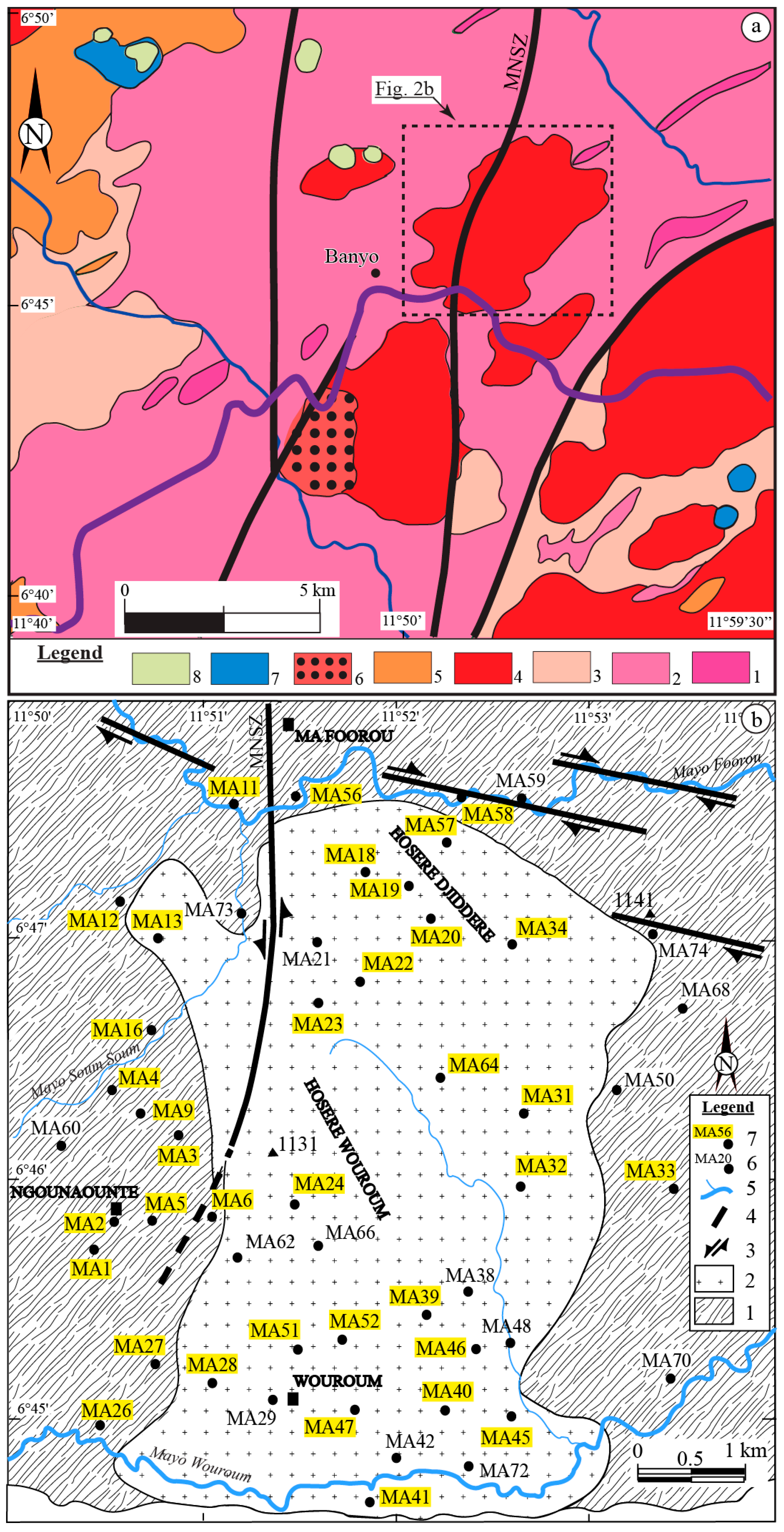
2. Geological Setting
3. Materials and Methods
4. Results
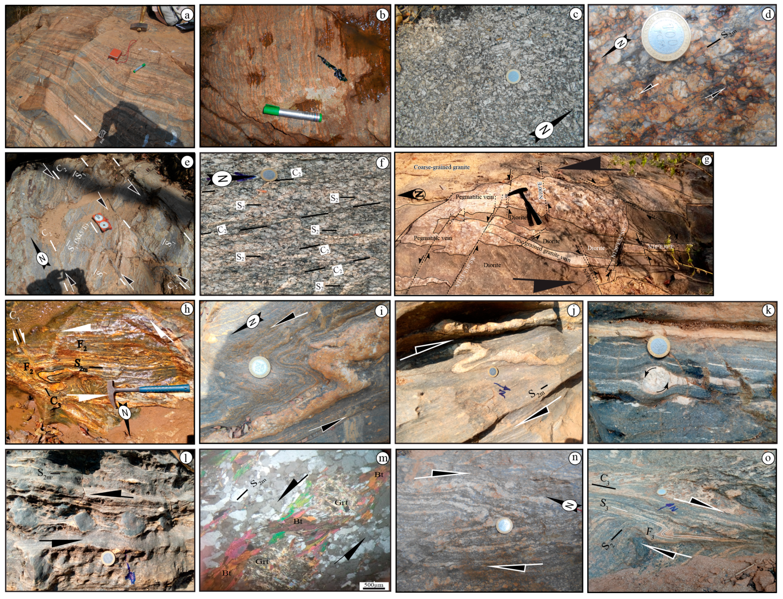
4.1. Petrography
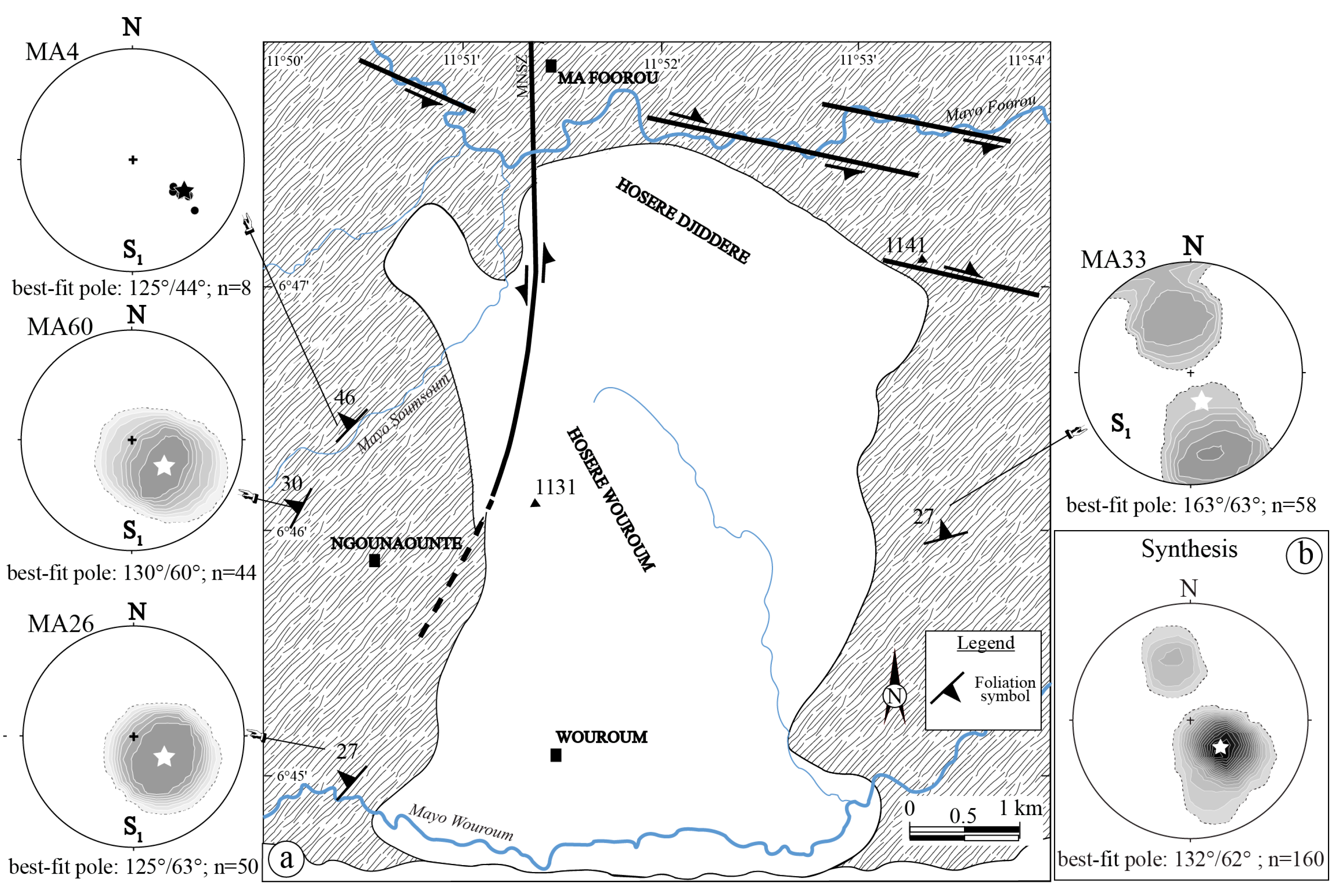
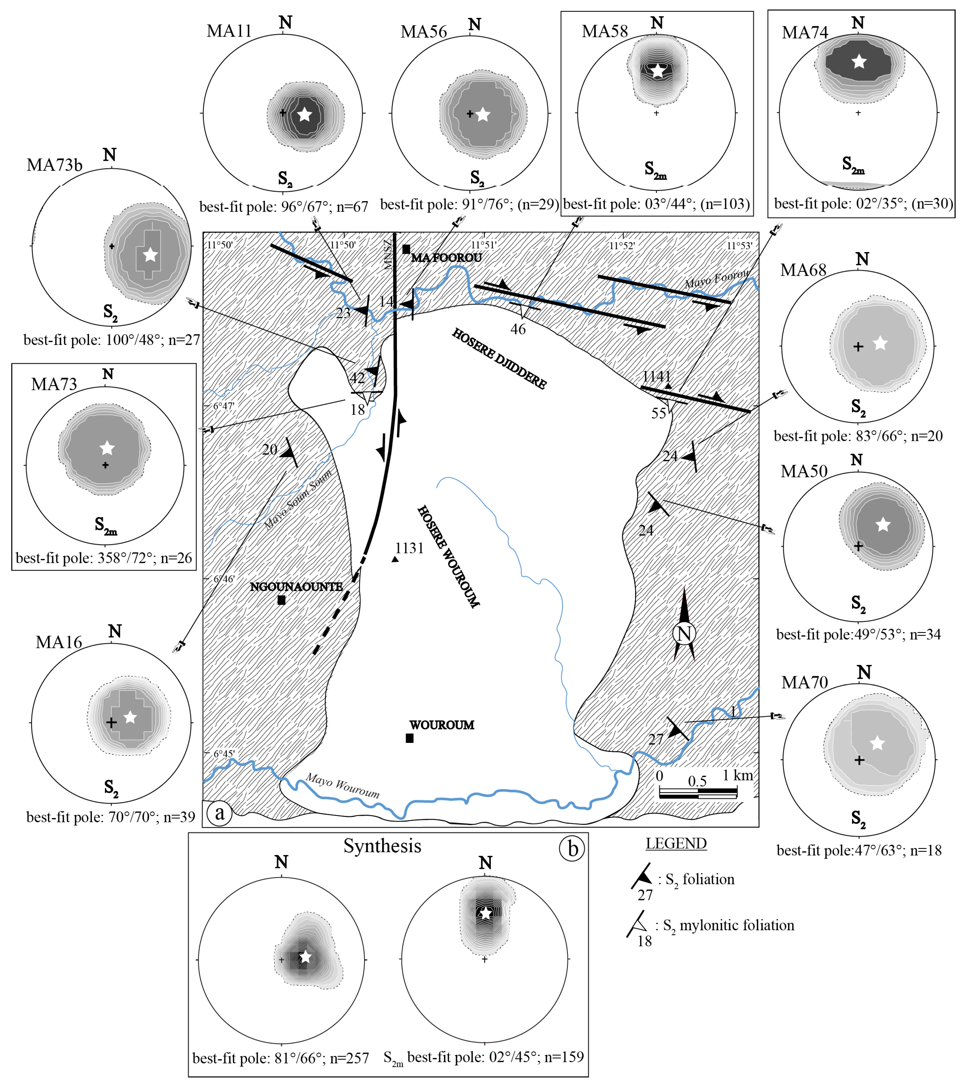
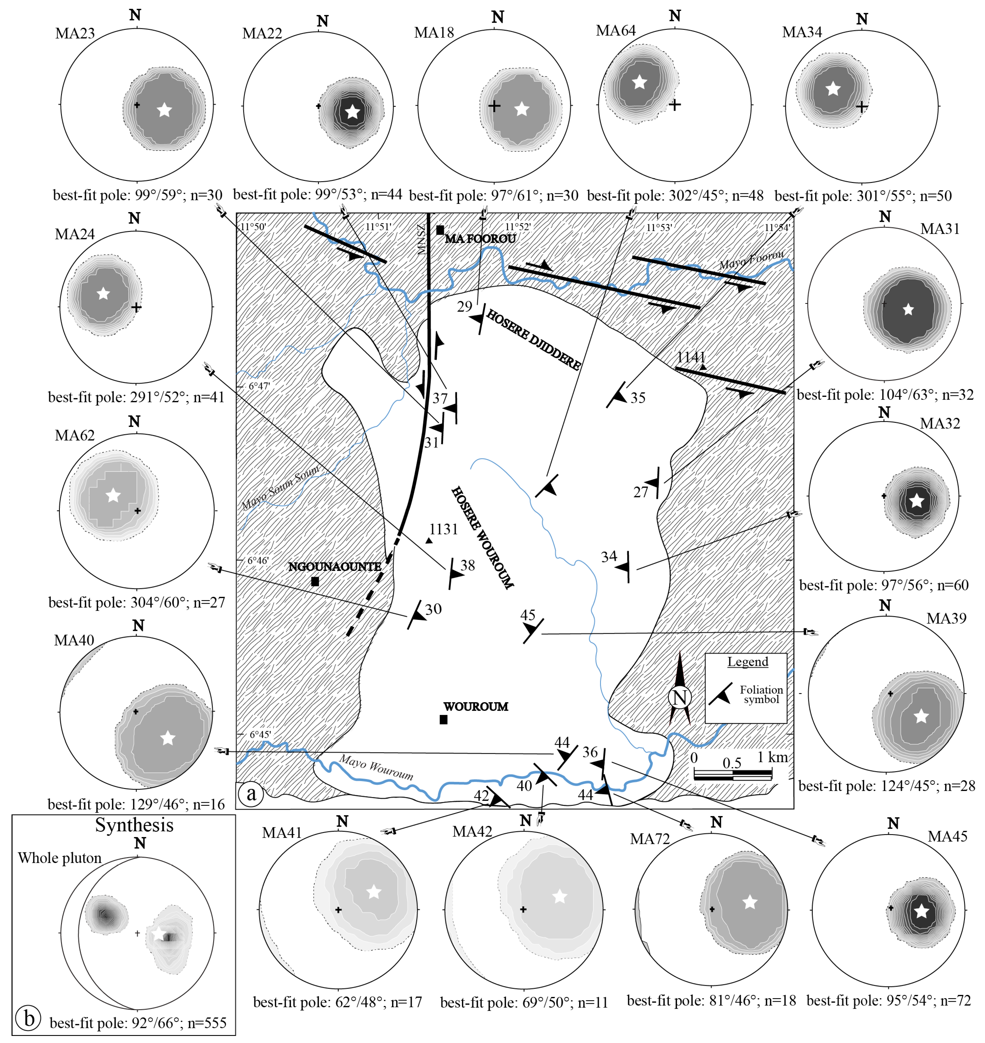
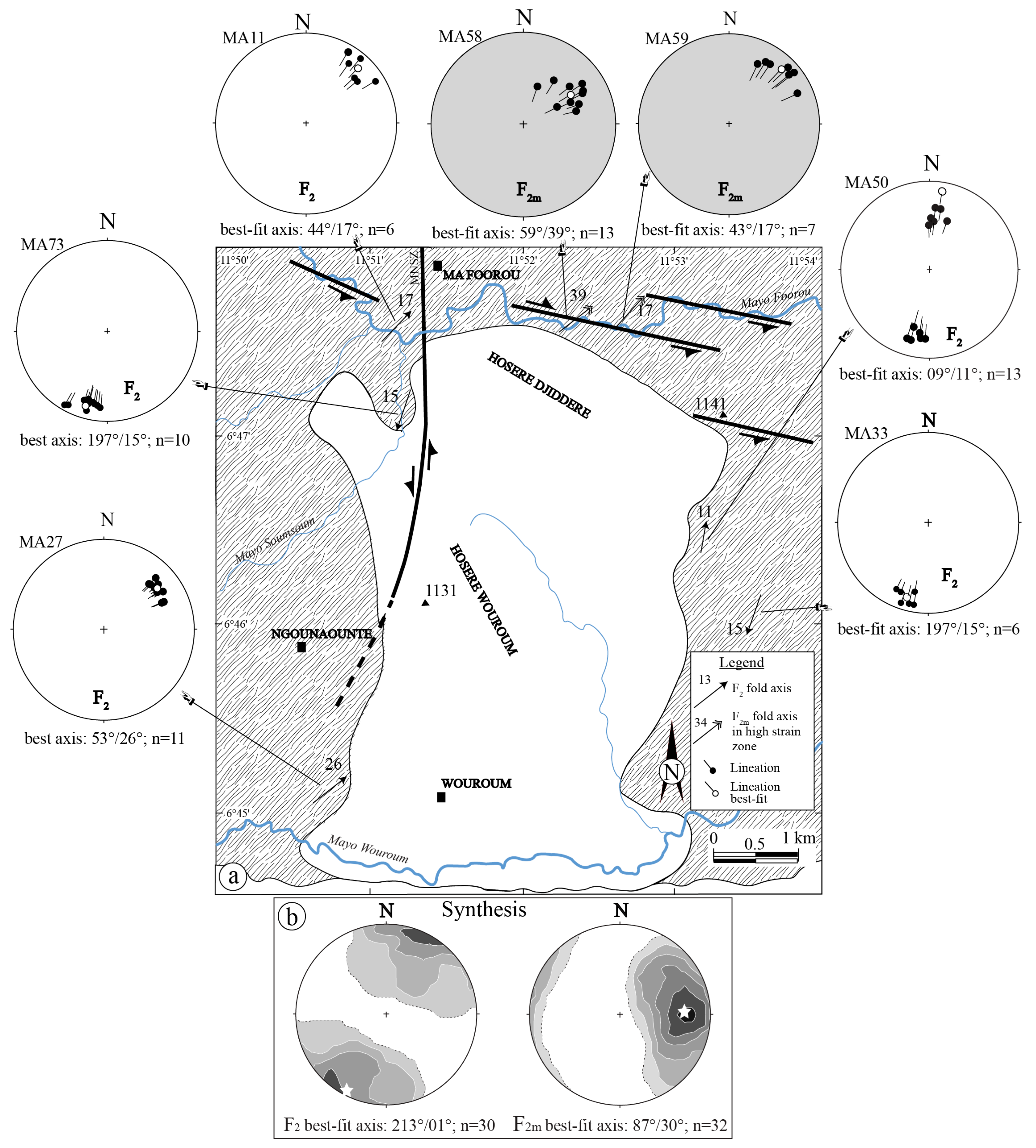
4.2. Structural Data
4.2.1. D1 Deformation
4.2.2. D2 Deformation
4.2.3. D3 Deformation Phase
4.3. Microstructures in Granite
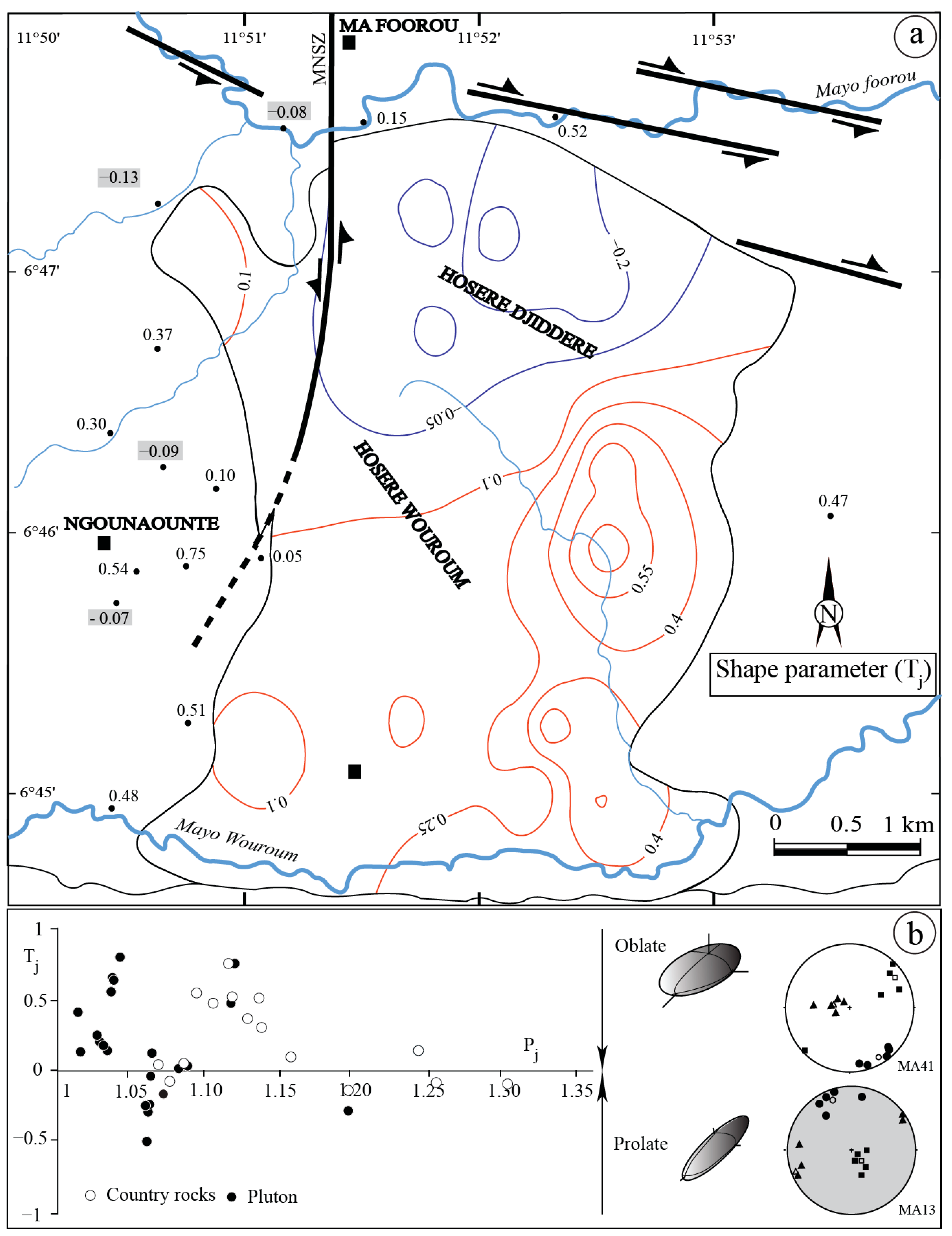
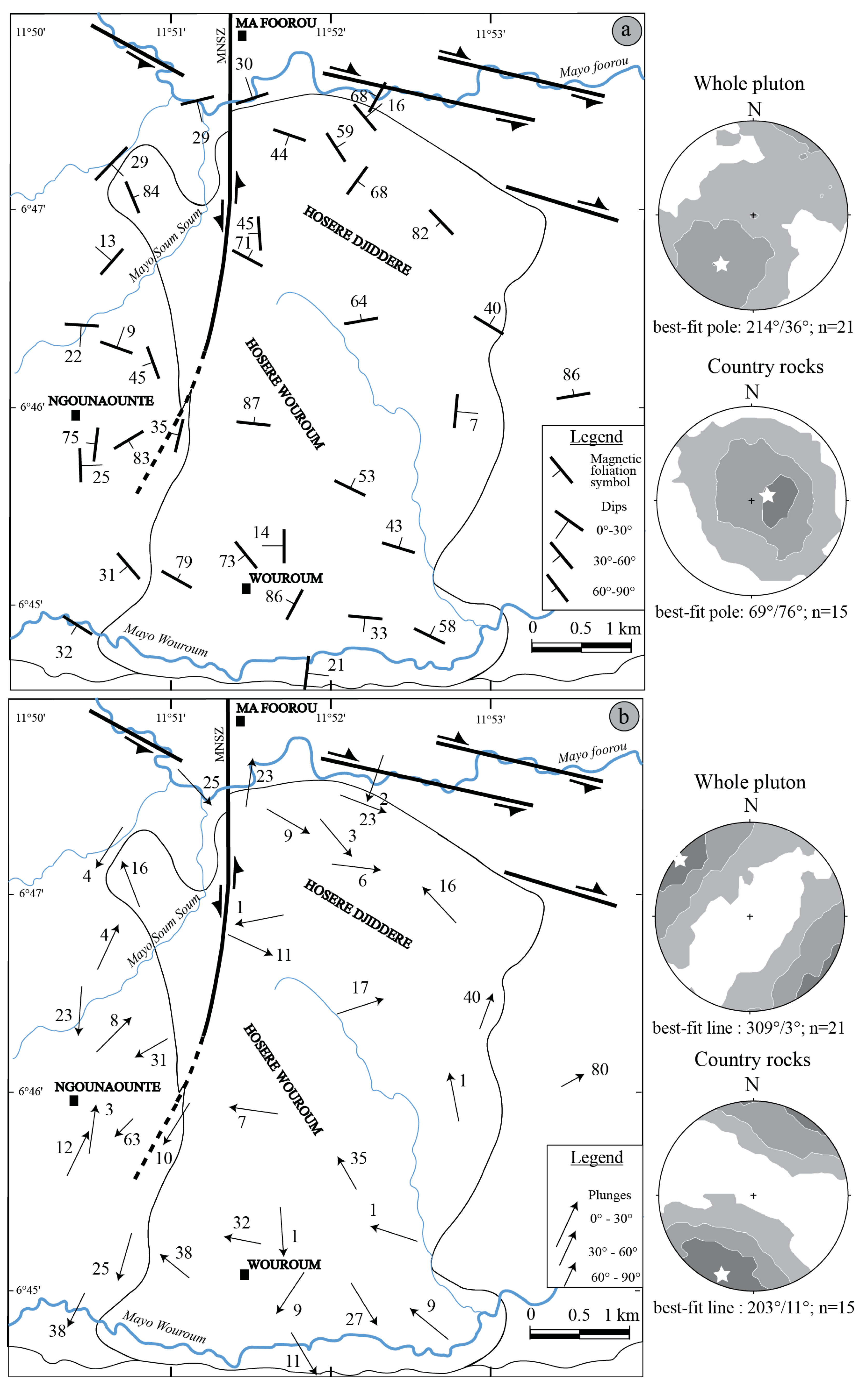
4.4. AMS Data
5. Discussion
5.1. Relationship Between Magnetic Fabric of NE Banyo Granite and Regional Deformation
5.2. Syn-Tectonic Emplacement of NE Banyo Pluton
5.3. Banyo Tectonics Integrated to the Regional Tectonic Evolution of the NCAB
5.4. NE Banyo Granitic Pluton Emplacement Mechanism
6. Conclusions
Author Contributions
Funding
Data Availability Statement
Acknowledgments
Conflicts of Interest
References
- Barbarin, B. A review of the relationships between granitoid types, their origins and their geodynamic environments. Lithos 1999, 46, 605–626. [Google Scholar] [CrossRef]
- Gleizes, G.; Leblanc, D.; Bouchez, J.L. Variscan granites of the Pyrenees revisited: Their role as syntectonic markers of the orogen. Terra Nova 1997, 9, 38–41. [Google Scholar] [CrossRef]
- de Saint Blanquat, M.; Tikoff, B.; Teyssier, C.; Vigneresse, J.L. Transpressional kinematics and magmatic arcs. In Continental Transpressional Tectonics; Holdsworth, R.E., Strachan, R.A., Dewey, F., Eds.; Geological Society: London, UK, 1998; Special Publication. [Google Scholar]
- Hutton, D.H.W. Granite emplacement mechanisms and tectonic controls: Inferences from deformation studies. Trans. R. Soc. Edinb. Earth Sci. 1988, 79, 245–255. [Google Scholar] [CrossRef]
- Ngako, V.; Njonfang, E. Plates amalgamation and plate destruction, the western Gondwana history. In Tectonics; Closson, D., Ed.; Intech: London, UK, 2011; 36p, Available online: https://www.intechopen.com/chapters/14070 (accessed on 23 February 2025).
- Paulsen, T.S.; Encarnacion, J.; Grunov, A.M.; Layer, P.W.; Watkeys, M. New age constraints for a short pulse on Ross orogen deformation triggered by East-West Gondwana suturing. Gondwana Res. 2007, 12, 417–427. [Google Scholar] [CrossRef]
- Tucker, R.D.; Kusky, T.M.; Buchwaldt, R.; Handke, M.J. Neoproterozoic nappes and superposed folding of the Itremo Group, west-central Madagascar. Gondwana Res. 2007, 12, 356–379. [Google Scholar] [CrossRef]
- Goscombe, B.D.; Gray, D.R. Structure and strain variation at mid-crustal levels in a transpressional orogen: A review of Kaoko belt structure and the character of West Gondwana amalgamation and dispersal. Gondwana Res. 2008, 13, 48–85. [Google Scholar] [CrossRef]
- Casquet, C.; Pankhurst, R.J.; Rappela, C.W.; Galindo, C.; Fanning, C.M.; Chiaradia, M.; Baldo, E.; Gonzalez-Casado, J.M.; Dahlquist, J.A. The Mesoproterozoic Maz terrane in the Western Sierra Pampeanas, Argentina, equivalent to the Arequipa-Antofalla block of southern Peru? Implications for West Gondwana margin evolution. Gondwana Res. 2008, 13, 163–175. [Google Scholar] [CrossRef]
- Ngako, V.; Affaton, P.; Njonfang, E. Pan-African tectonics in northwestern Cameroon: Implication for the history of Western Gondwana. Gondwana Res. 2008, 14, 509–522. [Google Scholar] [CrossRef]
- Toteu, S.F.; Penaye, J.; Djomani, Y.P. Geodynamic evolution of the Pan-African belt in central Africa with special reference to Cameroon. Can. J. Earth Sci. 2004, 41, 73–85. [Google Scholar] [CrossRef]
- Toteu, S.F.; de Wit, M.; Penaye, J.; Drost, K.; Tait, J.A.; Bouyo Houketchang, M.; Van Schmus, W.R.; Jelsma, H.; Moloto-A-Kenguemba, G.R.; da Silva Filho, A.F.; et al. Geochronology and correlations in the Central African Fold Belt along the northern edge of the Congo Craton: New insights from U-Pb dating of zircons from Cameroon, Central African Republic, and south-western Chad. Gondwana Res. 2022, 107, 296–324. [Google Scholar] [CrossRef]
- Caby, R.; Sial, A.N.; Arthaud, M.; Vauchez, A. Crustal evolution and the Braziliano orogeny in northeast Brazil. In The West African Orogens and Circum-Atlantic Correlatives; Dallmeyer, R.D., Lecorche, J.C.P.L., Eds.; Springer: Berlin/Heidelberg, Germany, 1991; p. 37. [Google Scholar]
- Castaing, C.; Triboulet, C.; Feybesse, J.L.; Chèvremont, P. Tectonometamorphic evolution of Ghana, Togo and Benin in the light of the Pan-African/Brasilliano orogeny. Tectonophysics 1993, 218, 323–342. [Google Scholar] [CrossRef]
- Ferré, E.; Gleizes, G.; Caby, R. Obliquely convergent tectonics and granite emplacement in the Trans-Saharan belts of Eastern Nigeria: A synthesis. Precambrian Res. 2002, 114, 199–219. [Google Scholar] [CrossRef]
- Brito Neves, B.B.; Van Schmus, W.R.; Fetter, A. North–western Africa North–Eastern Brazil: Major tectonic links and correlation problems. J. Afr. Earth Sci. 2002, 34, 275–278. [Google Scholar] [CrossRef]
- Njanko, T.; Nédélec, A.; Affaton, P. Syn-kinematic high-K calc-alkaline plutons associated with the Pan–African Central Cameroon shear zone (W-Tibati area): Petrology and geodynamic significance. J. Afr. Earth Sci. 2006, 44, 494–510. [Google Scholar] [CrossRef]
- Njanko, T.; Nédélec, A.; Kwekam, M.; Siquiéra, R.; Estéban, L. Emplacement and deformation of the Fomopéa pluton. Implication for the Panafrican history of Western Cameroon. J. Struct. Geol. 2010, 30, 306–320. [Google Scholar] [CrossRef]
- Archanjo, C.J.; Hollanda, M.H.B.M.; Rodrigues, S.W.O.; Brito Neves, B.B.; Armstrong, R. Fabrics of pre- and syntectonic granite plutons and chronology of shear zones in the Eastern Borborema Province, NE Brazil. J. Struct. Geol. 2008, 30, 310–326. [Google Scholar] [CrossRef]
- Yakeu, S.A.F.; Njanko, T.; Njonfang, E.; Errami, E.; Rochette, P.; Fozing, E.M. Transpresional granite-emplacement model: Structural and magnetic study of the Pan-African Bandja granitic pluton (West Cameroon). J. Earth Syst. Sci. 2016, 125, 179–202. [Google Scholar]
- Nomo Negue, E.; Tchameni, R.; Vanderhaeghe, O.; Sun, F.; Barbey, P.; Tekoum, L.; Fosso Tchunte, P.M.; Eglinger, A.; Saha Fouotsa, N.A. Structure and LA-ICP-MS zircon U-Pb dating of syntectonic plutons emplaced in the Pan-African Banyo Tcholliré shear zone (central north Cameroon). J. Afr. Earth Sci. 2017, 131, 251–271. [Google Scholar] [CrossRef]
- Bella Nke, B.E.; Njanko, T.; Mamtani, M.A.; Njonfang, E.; Rochette, P. Kinematic evolution of the Mbakop Pan-African granitoids (western Cameroon domain): An integrated AMS and EBSD approach. J. Struct. Geol. 2018, 111, 42–63. [Google Scholar] [CrossRef]
- Küster, D.; Liégeois, J.P. Sr, Nd isotopes and geochemistry of the Bayuda Desert high-grade metamorphic basement (Sudan): An early Pan-African oceanic convergent margin, not the edge of the East Saharan ghost craton? Precambrian Res. 2001, 109, 1–23. [Google Scholar] [CrossRef]
- Tchameni, R.; Pouclet, A.; Penaye, J.; Ganwa, A.A.; Toteu, S.F. Petrography and geochemistry of the Ngaoundéré Pan-African granitoids in Central North Cameroon: Implications for their sources and geological setting. J. Afr. Earth Sci. 2006, 44, 511–529. [Google Scholar] [CrossRef]
- Ngako, V.; Affaton, P.; Nnange, J.M.; Njanko, T. Pan-African tectonic evolution in central and southern Cameroon: Transpression and transtension during sinistral shear movements. J. Afr. Earth Sci. 2003, 36, 207–214. [Google Scholar] [CrossRef]
- Nzenti, J.P.; Kapajika, B.; Wörner, G.; Lubala, T.R. Syn-kinematic emplacement of granitoids in a Pan-African shear zone in Central Cameroon. J. Afr. Earth Sci. 2006, 45, 74–86. [Google Scholar] [CrossRef]
- Njiékak, G.; Dörr, W.; Tchouankoué, J.P.; Zulauf, G. U-Pb zircon and microfabric data of (meta) granitoids of western Cameroon: Constraints on the timing of pluton emplacement and deformation in the Pan-African belt of central Africa. Lithos 2008, 102, 46. [Google Scholar] [CrossRef]
- Njonfang, E.; Ngako, V.; Moreau, C.; Affaton, P. Restraining bends in high temperature shear zone: “the Central Cameroon”. J. Afr. Earth Sci. 2008, 52, 9–20. [Google Scholar] [CrossRef]
- Tchaptchet Tchato, D.; Schulz, B.; Nzenti, J.P. Electron microprobe dating and thermobarometry of Neoproterozoic metamorphic events in the Kékem area, Central African Fold Belt of Cameroon. Stuttgard 2009, 186, 95–109. [Google Scholar] [CrossRef]
- Tcheumenak Kouémo, J.; Njanko, T.; Kwekam, M.; Naba, S.; Bella Nke, B.E.; Yakeu Sandjo, A.F.; Fozing, E.M.; Njonfang, E. Kinematic evolution of the Fodjomekwet-Fotouni shear zone (West-Cameroon): Implications for emplacement of the Fomopéa and Bandja plutons. J. Afr. Earth Sci. 2014, 99, 261–275. [Google Scholar] [CrossRef]
- Fozing, E.M.; Njanko, T.; Seta, N.; Kwekam, M.; Njonfang, E.; Rochette, P. Structural characterization of the Misajé granitic pluton (NW Cameroon): Constraints from magnetic and field observations. Int. J. Earth Sci. 2016, 105, 2285–2309. [Google Scholar] [CrossRef]
- Fozing, E.M.; Mengou, A.C.; Njanko, T.; Téfo Fonkoua, A.; Tiseh, I.K.; Kwekam, M.; Chatué, N.C. Emplacement of the Dschang granitic pluton (west-Cameroon): Constraints from microstructures and magnetic fabrics. J. Afr. Earth Sci. 2019, 156, 144–157. [Google Scholar] [CrossRef]
- Fozing, E.M.; Kwekam, M.; Tcheumenak Kouémo, M.; Njanko, T.; Njonfang, E. Kinematic analysis of the Dschang granitic pluton (West-Cameroon): Implications to the Pan–African deformation of the Central African Fold belt in Cameroon during the post-collisional history of western Gondwana. Precambrian Res. 2021, 359, 106231. [Google Scholar] [CrossRef]
- Ntieche, B.; Ram Mohan, M.; Moundi, A. Granitoids of the Magba shear zone, West Cameroon, Central Africa: Evidences for emplacement under transpressive tectonic regime. J. Geol. Soc. India 2017, 89, 33–46. [Google Scholar] [CrossRef]
- Njiki Chatué, C.; Njanko, T.; Fozing, E.M.; Bella Nke, B.E.; Séta, N.; Njonfang, E. Field observations, magnetic fabrics and microstructures evidences of syn-kinematic emplacement of the Numba granitic pluton (western Cameroon domain). J. Afr. Earth Sci. 2020, 172, 104009. [Google Scholar] [CrossRef]
- Efon Awoum, J.; Fozing, E.M.; Kwekam, M.; Tcheumenak Kouémo, J.; Choumele Kana, S.C.; Achu Megnemo, L. Structural characterization of the Pan-African Ndiéki area in the Foumban-Bankim Shear Zone (West Cameroon): Constraints from field observations and microstructures. Arab. J. Geosci. 2020, 13, 831. [Google Scholar]
- Koch, P.; Weecksteen, G.; Jacques, E.M.; Chaput, M. Carte géologique de reconnaissance du Cameroun, Feuille Banyo N° NB 32 NE-E41, avec notice explicative. Direction des Mines et Géologie de l’Afrique Equatoriale Française et du Service des Mines du Cameroun. 1952. Available online: https://search.worldcat.org/fr/title/Carte-geologique-de-reconnaissance-du-Cameroun-1:500-000.-Feuille-NB-32-NE-E41-Banyo/oclc/492383088 (accessed on 23 February 2025).
- Makitie, H.; Baptiste, J.; Mero, Y.; Tucker, R.; Houketchang Bouyo, M.; Bernard, J.; Karinen, T.; Vic, G.; Fodoue, Y.; Sep Nlomngan, J.P.; et al. 1:200000-scale geological map of Cameroon Banyo Sheet NB 32 NE-E41, in press. Available online: https://search.worldcat.org/fr/title/Carte-geologique-de-reconnaissance-du-Cameroun-1:500-000.-Feuille-NB-32-NE-E41-Banyo/oclc/492383088 (accessed on 23 February 2025).
- Nzenti, J.P.; Barbey, P.; Macaudiére, J.P.; Soba, D. Origin and evolution of the late Precambrian high grade Yaoundé gneisses (Cameroon). Precambrian Res. 1988, 38, 91–109. [Google Scholar] [CrossRef]
- Toteu, S.F.; Michard, A.; Bertrand, J.M.; Rocci, G. U/Pb dating of Precambrian rocks from northern Cameroon, orogenic evolution and chronology of the Pan-African belt of central Africa. Precambrian Res. 1987, 37, 71–87. [Google Scholar] [CrossRef]
- Penaye, J.; Toteu, S.F.; Van Schumus, W.R.; Nzenti, J.P. U-Pb and Sm-Nd preliminary geochronologic data on the Yaoundé series Cameroon. Reinterpretation of the granulitic rocks as suture of a collision in the Central African Belt. CRAS Paris 1993, 317, 78. [Google Scholar]
- Toteu, S.F.; Van Schmus, W.R.; Penaye, J.; Michard, A. New U–Pb and Sm–Nd data from north-central Cameroon and its bearing on the pre Pan-African history of central Africa. Precambrian Res. 2001, 108, 45–73. [Google Scholar] [CrossRef]
- Trompette, R. Geology of Western Gondwana (2000–500 Ma). Pan-African-Brasiliano Aggregation of South America and Africa; AA Balkema edition: Rotterdam, The Netherlands, 1994; 350p. [Google Scholar]
- Vauchez, A.; Neves, S.P.; Caby, R.; Corsini, M.E.; Silva, M.; Arthaud, M.; Amaro, V.E. The Borborema shear zone system, NE Brazil. J. S. Am. Earth Sci. 1995, 8, 247–266. [Google Scholar] [CrossRef]
- Lerouge, C.; Cocherie, A.; Toteu, S.F.; Penaye, J.; Milési, J.P.; Tchameni, R.; Nsifa, E.; Fanning, C.M.; Deloule, E. Shimp U–Pb zircon age evidence for Paleoproterozoic sedimentation and 2.05 Ga syn-tectonic plutonism in the Nyong group, South-Western Cameroon: Consequences for the Eburnean–Transamazonian belt of NE Brazil and Central Africa. J. Afr. Earth Sci. 2006, 44, 413–427. [Google Scholar] [CrossRef]
- Cordani, U.G.; D’Agrella-Filho, M.S.; Brito-Neves, B.B.; Trindade, R.I.F. Tearing up Rodinia: The Neoproterozoic palaeogeography of South American cratonic fragments. Terra Nova 2003, 15, 350–359. [Google Scholar] [CrossRef]
- Ferreira, V.P.; Sial, A.N.; Pimentel, M.M.; Moura, C.A.V. Intermediate to acidic magmatism and crustal evolution in the Transversal Zone, northeastern Brazil. In Geologia do Continente Sul-Americano: Evolução da Obra de Fernando Flàvio Marques de Almeida; Mantesso-Neto, V., Bartorelli, A., Carneiro, C., Brito-Neves, B.B., Eds.; Beca: São Paulo, Brazil, 2004. [Google Scholar]
- Abdelsalam, M.G.; Liégeois, J.P.; Ster, R.J. The Sahara metacraton. J. Afr. Earth Sci. 2002, 34, 119–136. [Google Scholar] [CrossRef]
- Liégeois, J.P.; Abdelsalam, M.G.; Ennih, N.; Ouabadi, A. Metacraton: Nature, genesis and behavior. Gondwana Res. 2013, 23, 220–237. [Google Scholar] [CrossRef]
- Toteu, S.F. Geochemical characterization of the main petrographical and structural units of northern Cameroon: Implications for Pan-African evolution. J. Afr. Earth Sci. 1990, 10, 615–624. [Google Scholar] [CrossRef]
- Toteu, S.F.; Van Schmus, W.R.; Penaye, J.; Nyobé, J.B. U-Pb and Sm-Nd evidence for Eburnean and Pan-African high-grade metamorphism in cratonic rocks of Southern Cameroon. Precambrian Res. 1994, 67, 321–347. [Google Scholar] [CrossRef]
- Bessoles, B.; Trompette, R. Géologie de l’Afrique. In La chaîne Panafricaine: “Zone Mobile d’Afrique Centrale (Partie Sud) et Zone Mobile Soudanaise”; Mém. B.R.G.M.: Paris, France, 1980; Volume 92, p. 396. [Google Scholar]
- Ngnotué, T.; Nzenti, J.P.; Barbey, P.; Tchoua, F.M. The Ntui-betamba High-grade gneiss: A northward extension of the Pan-African Yaoundé gneiss in Cameroon. J. Afr. Earth Sci. 2000, 2, 369–381. [Google Scholar] [CrossRef]
- Oliveira, E.P.; Toteu, S.F.; Araújo, M.N.C.; Carvalho, M.J.; Nascimento, R.S.; Bueno, J.F.; McNaughton, N.; Basilici, G. Geologic correlation between the Neoproterozoic Sergipano belt (NE Brazil) and the Yaoundé belt (Cameroon, Africa). J. Afr. Earth Sci. 2006, 44, 470–478. [Google Scholar] [CrossRef]
- Toteu, S.F.; Yongue Fouateu, R.; Penaye, J.; Tchakounté, J.; Sémé Mouangue, A.C.; Van Schmus, W.R.; Deloule, E.; Stendal, H. U–Pb dating of plutonic rocks involved in the nappe tectonic in southern Cameroon: Consequence for the Pan-African orogenic evolution of the central African fold belt. J. Afr. Earth Sci. 2006, 44, 479–493. [Google Scholar] [CrossRef]
- Nédélec, A.; Macaudière, J.; Nzenti, J.P.; Barbey, P. Evolution structurale et métamorphique des schistes de Mbalmayo (Cameroun). In Implications Pour la Structure de la Zone Mobile Panafricaine d’Afrique Centrale au Contact du Craton du Congo; CRAS: Paris, France, 1986. [Google Scholar]
- Toteu, S.F.; Penaye, J.; Deloule, E.; Van Schmus, W.R.; Tchameni, R. Diachronous evolution of volcano-sedimentary basins north of the Congo craton: Insights from U–Pb ion microprobe dating of zircons from the Poli, Lom and Yaoundé Groups (Cameroon). J. Afr. Earth Sci. 2006, 44, 428–442. [Google Scholar] [CrossRef]
- Tchakounté, J.; Eglinger, A.; Toteu, S.F.; Zeh, A.; Nkoumbou, C.; Mvondo Ondoa, J.; Penaye, J.; de Wit, M.; Barbey, P. The Adamawa-Yadé domain, a piece of Archaean crust in the Neoproterozoic Central African Orogenic belt (Bafia area, Cameroon). Precambrian Res. 2017, 299, 210–229. [Google Scholar] [CrossRef]
- Tagne Kamga, G. Petrogenesis of the Neoproterozoic Ngondo plutonic complex (West-Cameroon, Central Africa): A case of late-collisional ferro-potassic magmatism. J. Afr. Earth Sci. 2003, 36, 149–171. [Google Scholar] [CrossRef]
- Kwekam, M.; Liégeois, J.P.; Njonfang, E.; Affaton, P.; Hartmann, G.; Tchoua, F.M. Nature, origin and significance of the Fomépéa Pan–Africain high–K calc–alkaline plutonic complex in the Central Africa Fold Belt (Cameroon). J. Afr. Earth Sci. 2010, 57, 79–95. [Google Scholar] [CrossRef]
- Penaye, J.; Toteu, S.F.; Michard, A.; Bertrand, J.M.; Dautel, D. Reliques Granulitiques d’âge Protérozoïque Inférieur dans la Zone Mobile Panafricaine d’Afrique Centrale au Cameroun; Géochronologie U-Pb sur Zircon au Cameroun; CRAS: Paris, France, 1989; Volume 309, pp. 313–315. [Google Scholar]
- Passchier, C.W.; Trouw, R.A.J. Microtectonics; Springer: Berlin/Heidelberg, Germany, 2005. [Google Scholar]
- Bouchez, J.L.; Lister, G.S.; Nicolas, A. Fabric asymmetry and shear sense in movement zones. Geol. Rundschan 1983, 72, 410–419. [Google Scholar] [CrossRef]
- Allmendinger, R.W.; Cardonzo, N.C.; Fisher, D. Structural Geology Algorithms: Vectors and Tensors; Cambridge University Press: New York, NY, USA, 2013; p. 289. [Google Scholar]
- Cardonzo, N.C.; Allmendinger, R.W. Spherical projections with OSXStereonet. Comput. Geosci. 2013, 50, 193–205. [Google Scholar] [CrossRef]
- Ragan, D.M. Structural Geology: An Introduction to Geometrical Techniques, 2nd ed.; John Wiley and Sons: New York, NY, USA, 1973; p. 208. [Google Scholar]
- Tarling, D.H.; Hrouda, F. The Magnetic Anisotropy of Rocks; Chapman and Hall: London, UK, 1993; p. 217. [Google Scholar]
- Goscombe, B.D.; Passchier, C.W. Asymmetric boudins as shear indicators-an assessment from field data. J. Struct. Geol. 2003, 25, 575–589. [Google Scholar] [CrossRef]
- Fossen, H. Structural Geology; Cambridge University Press: New York, NY, USA, 2010; p. 481. [Google Scholar]
- Eggleton, R.A. The ordering path for igneous K-feldspar megacrysts. Am. Mineral. 1979, 64, 906–911. [Google Scholar]
- Eggleton, R.A.; Buseck, P.R. The orthoclase–microcline inversion: A high-resolution TEM study and strain analysis. Contr. Mineral. Petrol. 1989, 74, 123–133. [Google Scholar] [CrossRef]
- Paterson, S.R.; Vernon, R.H.; Tobisch, O.T. A review for the identification of magmatic and tectonic foliations in granitoids. J. Struct. Geol. 1989, 11, 349–363. [Google Scholar] [CrossRef]
- Paterson, S.R.; Tobisch, O.T. Rates of processes in magmatic arcs: Implications for the timing and nature of pluton emplacement and wall rock deformation. J. Struct. Geol. 1992, 14, 291–300. [Google Scholar] [CrossRef]
- Vernon, R.H. Review of microstructural evidence of magmatic and solid-state flow. Vis. Geosci. 2000, 5, 1–23. [Google Scholar] [CrossRef]
- Vernon, R.H. A Practical Guide to Rock Microstructure; Cambridge University Press: New York, NY, USA, 2004. [Google Scholar]
- Nédélec, A.; Bouchez, J.L. Pétrologie des Granites; Vuibert; Société géologique de France: Paris, France, 2011; p. 306. [Google Scholar]
- Rochette, P. Magnetic susceptibility of the rock matrix related to magnetic fabric studies. J. Struct. Geol. 1987, 9, 1015–1020. [Google Scholar] [CrossRef]
- Venera, Z.; Shulmann, K.; Kröner, A. Intrusion within a transtensional tectonic domain: The Cista granodiorite (Bohemian Massif) structure and rheological modeling. J. Struct. Geol. 2000, 22, 1437–1454. [Google Scholar] [CrossRef]
- Rochette, P.; Jackson, M.; Aubourg, C. Rock magnetism and the interpretation of anisotropy of magnetic susceptibility. Rev. Geophys. 1992, 30, 209–222. [Google Scholar] [CrossRef]
- Bouchez, J.L. Granite is never isotropic: An introduction to AMS studies of granitic rocks. In Granite: From Segregation of Melt to Emplacement Fabrics; Bouchez, J.L., Hutton, D.W.H., Stephens, W.E., Eds.; Kluwer Academic Publishers: Dordrecht, The Netherlands, 1997; pp. 95–112. [Google Scholar]
- Vanderhaeghe, O. Melt segregation, pervasive melt migration and magma mobility in the continental crust: The structural record from pores to orogens. Phys. Chem. Earth Part A Solid Earth Geod. 2001, 26, 213–223. [Google Scholar] [CrossRef]
- Dawaï, D.; Tchameni, R.; Bascou, J.; Wangmene, A.S.; Tchunte Fosso, M.P.; Bouchez, J.L. Microstructures and magnetic fabrics of the Ngaoundéré granite pluton (Cameroon): Implications to the late-Pan-African evolution of Central Cameroon shear zone. J. Afr. Earth Sci. 2017, 129, 887–897. [Google Scholar] [CrossRef]
- Saha Fouotsa, A.N.; Tchameni, R.; Nomo Negue, E.; Daouda, D.; Penaye, J.; Fosso Tchunte Fosso, P.M. Polyphase deformation in the Mbé-Sassa-Bersi area: Implications on the tectono-magmatic history of the area and the tectonic evolution of the Tcholliré-Banyo and Central Cameroon Shear Zones (Central North Cameroon). J. Geosci. 2018, 6, 41–54. [Google Scholar]
- Ngako, V. Evolution Métamorphique et Structurale de la Bordure Sud-Ouest de la “série de Poli” (Segment Camerounais de la Chaîne Panafricaine). Ph.D. Thesis, Mémoires et documents du Centre Armoricain d’Etude Structurale des Socles. Université de Rennes, Rennes, France, 1986. [Google Scholar]
- Penaye, J. Pétrologie et Structurale des Ensembles Métamorphiques du Sud-Est de Poli (Nord-Cameroun). Ph.D. Thesis, Université de Nancy, INPL, Nancy, France, 1988; 162p. [Google Scholar]
- Ferré, E.C.; Caby, R.; Peucat, J.J.; Capdevilla, R.; Monié, P. Pan-African postcollisional ferro-potassic granite and quartz-monzonite plutons of Eastern Nigeria. Lithos 1998, 45, 255–279. [Google Scholar] [CrossRef]
- Fossen, H.; Tikoff, B. The deformation matrix for simultaneous simple shearing, pure shearing, and volume change, and its application to transpression/transtension tectonics. J. Struct. Geol. 1993, 15, 413–422. [Google Scholar] [CrossRef]
- Fossen, H.; Tikoff, B. Extended models of transpression and transtension, and application to tectonic settings. In Continental Transpressional and Transtensional Tectonics; Holdsworth, R.E., Strachan, R.A., Dewey, J.F., Eds.; Special Publication; Geological Society: London, UK, 1998; Volume 135, pp. 15–33. [Google Scholar] [CrossRef]
- Tikoff, B.; Fossen, H. Simultaneous pure shear and simple shear: The unifying deformation matrix. Tectonophysics 1992, 217, 267–283. [Google Scholar] [CrossRef]
- Fossen, H.; Tikoff, T.B.; Teyssier, C.T. Strain modeling of transpressional and transtensional deformation. Nor. Geol. Tidsskr. 1994, 74, 134–145. [Google Scholar]
- Bella Nké, B.E.; Njanko, T.; Mamtani, M.A.; Njonfang, E.; Rochette, P. Time relationship between emplacement, fabric development and regional deformation of the Manchi granitic pluton (western-Cameroon domain)-an integrated AMS, CPO and microstructural investigation. J. Struct. Geol. 2022, 160, 104619. [Google Scholar] [CrossRef]
- Ngako, V.; Jegouza, P.; Nzenti, J.P. Le cisaillement centre Camerounais. Rôle structural et géodynamique dans l’orogenèse panafricaine. C.R. Acad. Sci. 1991, 313, 457–463. [Google Scholar]
- Tikoff, B.; Greene, D. Stretching lineations in transpressional shear zones: An example from the Sierra Nevada Batholith, California. J. Struct. Geol. 1997, 19, 29–39. [Google Scholar] [CrossRef]
- Tikoff, B.; Peterson, K. Physical experiments of transpressional folding. J. Struct. Geol. 1998, 20, 661–672. [Google Scholar] [CrossRef]


| [5] Deformation Events (Three Major Tectonic Events) | [11,12] Deformation Events (Four Major Tectonic Events) | |
|---|---|---|
| D1 |
|
|
| D2 |
|
|
| D3 |
|
|
| Sites | Geographic Coordinates | Mean AMS Parameters | Mean Eigenvectors | ||||||||
|---|---|---|---|---|---|---|---|---|---|---|---|
| K1 | K2 | K3 | |||||||||
| Long. E (°) | Lat. N (°) | Km (×10−3 SI) | Pj | Tj | Dec | Inc | Dec | Inc | Dec | Inc | |
| Country rock | |||||||||||
| MA1 | 11.840 | 6.775 | 0.42 | 1.08 | −0.07 | 26 | 12 | 116 | 26 | 268 | 75 |
| MA2 | 11.839 | 6.778 | 0.58 | 1.09 | 0.54 | 8 | 3 | 304 | 60 | 97 | 25 |
| MA3 | 11.854 | 6.793 | 9.83 | 1.16 | 0.10 | 240 | 31 | 318 | 1 | 72 | 45 |
| MA4 | 11.860 | 6.785 | 1.04 | 1.14 | 0.30 | 184 | 23 | 93 | 6 | 1 | 68 |
| MA5 | 11.852 | 6.774 | 0.65 | 1.12 | 0.75 | 225 | 63 | 62 | 26 | 329 | 7 |
| MA6 | 11.869 | 6.788 | 0.35 | 1.09 | 0.05 | 212 | 10 | 306 | 23 | 104 | 65 |
| MA9 | 11.852 | 6.805 | 10.59 | 1.30 | −0.09 | 45 | 8 | 313 | 5 | 199 | 81 |
| MA11 | 11.833 | 6.805 | 5.82 | 1.26 | −0.08 | 137 | 25 | 232 | 7 | 345 | 61 |
| MA12 | 11.836 | 6.803 | 4.06 | 1.20 | −0.13 | 213 | 4 | 122 | 23 | 314 | 66 |
| MA16 | 11.869 | 6.811 | 0.66 | 1.13 | 0.37 | 25 | 4 | 294 | 11 | 131 | 77 |
| MA26 | 11.845 | 6.767 | 0.18 | 1.14 | 0.51 | 207 | 34 | 299 | 3 | 34 | 58 |
| MA27 | 11.864 | 6.773 | 0.19 | 1.07 | 0.04 | 193 | 25 | 291 | 18 | 53 | 59 |
| MA33 | 11.901 | 6.772 | 0.57 | 1.11 | 0.47 | 61 | 80 | 264 | 10 | 174 | 4 |
| MA56 | 11.861 | 6.806 | 0.86 | 1.24 | 0.15 | 8 | 23 | 274 | 13 | 162 | 60 |
| MA58 | 11.884 | 6.806 | 0.57 | 1.12 | 0.52 | 199 | 2 | 287 | 65 | 119 | 22 |
| Pluton | |||||||||||
| MA13 | 11.869 | 6.809 | 0.08 | 1.03 | 0.20 | 339 | 16 | 139 | 72 | 248 | 6 |
| MA18 | 11.873 | 6.808 | 0.20 | 1.09 | 0.04 | 120 | 9 | 220 | 42 | 18 | 46 |
| MA19 | 11.867 | 6.836 | 0.19 | 1.06 | −0.49 | 140 | 3 | 46 | 61 | 230 | 31 |
| MA20 | 11.868 | 6.822 | 0.18 | 1.06 | −0.29 | 97 | 65 | 212 | 11 | 306 | 22 |
| MA22 | 11.870 | 6.799 | 0.15 | 1.06 | −0.24 | 259 | 1 | 235 | 67 | 86 | 45 |
| MA23 | 11.858 | 6.799 | 0.14 | 1.07 | −0.16 | 115 | 11 | 347 | 67 | 208 | 19 |
| MA24 | 11.854 | 6.769 | 0.18 | 1.06 | 0.13 | 278 | 7 | 82 | 83 | 188 | 3 |
| MA28 | 11.863 | 6.756 | 0.19 | 1.07 | 0.04 | 309 | 38 | 109 | 46 | 210 | 11 |
| MA31 | 11.886 | 6.797 | 0.16 | 1.04 | 0.65 | 20 | 40 | 115 | 7 | 213 | 50 |
| MA32 | 11.909 | 6.770 | 0.16 | 1.04 | 0.80 | 349 | 1 | 98 | 10 | 274 | 83 |
| MA34 | 11.891 | 6.806 | 0.28 | 1.20 | −0.28 | 317 | 16 | 169 | 74 | 49 | 8 |
| MA39 | 11.857 | 6.763 | 0.17 | 1.03 | 0.14 | 330 | 35 | 87 | 42 | 207 | 37 |
| MA45 | 11.867 | 6.757 | 0.16 | 1.04 | 0.56 | 301 | 9 | 44 | 57 | 205 | 32 |
| MA46 | 11.869 | 6.753 | 0.15 | 1.04 | 0.63 | 288 | 1 | 19 | 43 | 199 | 47 |
| MA57 | 11.865 | 6.800 | 0.13 | 1.06 | −0.25 | 111 | 23 | 213 | 7 | 231 | 74 |
| MA64 | 11.885 | 6.076 | 0.14 | 1.06 | −0.04 | 72 | 17 | 307 | 62 | 169 | 26 |
| MA47 | 11.861 | 6.750 | 1.29 | 1.03 | 0.18 | 214 | 9 | 4 | 67 | 118 | 4 |
| MA51 | 11.856 | 6.756 | 0.48 | 1.03 | 0.25 | 281 | 32 | 168 | 2 | 51 | 17 |
| MA52 | 11.857 | 6.757 | 4.89 | 1.08 | 0.02 | 176 | 1 | 260 | 14 | 92 | 76 |
| MA40 | 11.868 | 6.751 | 0.40 | 1.02 | 0.14 | 148 | 27 | 251 | 13 | 3 | 57 |
| MA41 | 11.863 | 6.745 | 0.53 | 1.01 | 0.41 | 149 | 11 | 55 | 17 | 277 | 69 |
Disclaimer/Publisher’s Note: The statements, opinions and data contained in all publications are solely those of the individual author(s) and contributor(s) and not of MDPI and/or the editor(s). MDPI and/or the editor(s) disclaim responsibility for any injury to people or property resulting from any ideas, methods, instructions or products referred to in the content. |
© 2025 by the authors. Licensee MDPI, Basel, Switzerland. This article is an open access article distributed under the terms and conditions of the Creative Commons Attribution (CC BY) license (https://creativecommons.org/licenses/by/4.0/).
Share and Cite
Mengou, A.C.; Bella Nke, B.E.; Njanko, T.; Rochette, P.; Onana, R.K.; Demory, F.; Njonfang, E. Structural Characterization of the Pan-African Banyo Area (Western Cameroon Domain): Constraints from Field Observations, Structures and AMS. Geosciences 2025, 15, 99. https://doi.org/10.3390/geosciences15030099
Mengou AC, Bella Nke BE, Njanko T, Rochette P, Onana RK, Demory F, Njonfang E. Structural Characterization of the Pan-African Banyo Area (Western Cameroon Domain): Constraints from Field Observations, Structures and AMS. Geosciences. 2025; 15(3):99. https://doi.org/10.3390/geosciences15030099
Chicago/Turabian StyleMengou, Alys Calore, Bertille Edith Bella Nke, Théophile Njanko, Pierre Rochette, Roland Kanse Onana, François Demory, and Emmanuel Njonfang. 2025. "Structural Characterization of the Pan-African Banyo Area (Western Cameroon Domain): Constraints from Field Observations, Structures and AMS" Geosciences 15, no. 3: 99. https://doi.org/10.3390/geosciences15030099
APA StyleMengou, A. C., Bella Nke, B. E., Njanko, T., Rochette, P., Onana, R. K., Demory, F., & Njonfang, E. (2025). Structural Characterization of the Pan-African Banyo Area (Western Cameroon Domain): Constraints from Field Observations, Structures and AMS. Geosciences, 15(3), 99. https://doi.org/10.3390/geosciences15030099