Article

Updated Chronology of the Last Deglaciation in the Făgăraş Mts (Romania)

1
Institute for Geological and Geochemical Research, HUN-REN Research Centre for Astronomy and Earth Sciences, Budaörsi út 45, 1112 Budapest, Hungary
2
CSFK, MTA Centre of Excellence, 1121 Budapest, Hungary
3
Department of Geography, Institute of Advanced Environmental Research, West University of Timisoara, 300223 Timisoara, Romania
4
Aix-Marseille Université, CEREGE, CNRS-IRD—Collége de France—INRAE, BP 80, CEDEX 4, 13545 Aix-en-Provence, France
*
Authors to whom correspondence should be addressed.
ASTER Team: Didier Bourlès, Georges Aumaître, Karim Keddadouche.
Geosciences 2025, 15(3), 109; https://doi.org/10.3390/geosciences15030109
Submission received: 12 February 2025 / Revised: 10 March 2025 / Accepted: 13 March 2025 / Published: 18 March 2025
(This article belongs to the Special Issue Geochronology and Chemostratigraphy of Quaternary Environment)

Abstract

:
So far, published geochronological data poorly constrain the Late Pleistocene glacial fluctuations in the Făgăraş Mts (Southern Carpathians, Romania). The deglaciation chronology in the central Făgăraş Mts is supported by new (n = 5) and recalculated (n = 5) 10Be exposure ages from a southern and two northern valleys. Cosmic ray exposure (CRE) ages were calculated considering the effects of surface denudation, uplift and snow-shielding. A 10Be exposure age obtained from a glacial landform representing the last glacierets of the central Făgăraş Mts yielded an age of 13.3 ± 1.2 ka. A polished bedrock sample and a moraine boulder constrain the age of a cirque glacier stage to 14.5 ± 1.5 ka, while quite coherent CRE ages from two erratic boulders place the previous stage at ~18.7 ka (18.6 ± 1.7 ka and 18.7 ± 1.7 ka). These glacial stages coincide with major deglaciation stages M4 and M2a reconstructed in the Retezat Mts, derived from comparable CRE ages calculated using the same methodology; however, geomorphological and/or geochronological evidence of the intermediate stages is still not found in the central Făgăraş Mts. All CRE ages gathered from the landforms corresponding to the more extended glacial stages are younger than expected from their morphostratigraphic position and thus considered as minimum age constraints. However, considering the coherent CRE ages of the above morphostratigraphic stage, it is likely that the balanced-budget glaciological conditions corresponding to these more extended stages prevailed before ~19 ka and likely coincided with the cold peaks of the Marine Isotope Stage 2. The currently available in situ 10Be data do not support the existence of a period of glacier advance during the Holocene or Greenland Stadial-1 (Younger Dryas) in the central Făgăraş Mts.

1. Introduction

The ~300 km long, E–W-trending Southern Carpathians (~45.2–45.6° N) with 10 peaks rising over 2500 m above sea level (asl) are a prominent orographic object in southeastern Europe. The geomorphological indication of Quaternary glaciation in these currently unglaciated mountain ranges was recognized as early as the late 19th century [1,2]. Subsequent geomorphological research found evidence for multiple glacial stages [3,4,5,6]. Despite the temperate continental climate, glacially sculpted landscapes are typical above ~1100 m asl [3,4]. The most evident and widespread geomorphological signs of past glaciations are glacial cirques observed in all the massifs rising above 1800 m [7,8].
In the Southern Carpathians, the distribution of glacial landforms (cirques, glacial valleys and moraines) points to the presence of glacial relief in 15 mountain massifs [4,5,9]. The main areas of the Quaternary glaciation were undoubtedly the Retezat, Parâng and Făgăraş mountains, where the imprint of glacial fluctuations has left unequivocal traces on the landscape [4,5,8]. Starting from cirques and plateaus above 2000 m asl, valley glaciers, some of them longer than 10 km, descended to 1050–1200 m asl in these ranges and several moraine generations of the valleys are indicative of glacier fluctuations [4,9]. The moraine generations and the corresponding glacial stages were correlated based on geomorphological and geometrical considerations among the neighboring massifs and further surrounding major glacial regions in the 20th century [4,10].
Cosmogenic nuclide dating has dramatically improved the ability to assign an age to palaeoglacial features (e.g., Balco [11], Gosse and Phillips [12]). Cosmogenic nuclide exposure age dating of glacial landforms was initiated in the Retezat Mts in the early 2000s [13,14] and later pilot studies were performed in the Parâng Mts [15,16] in the Southern Carpathians. In some parts of the Făgăraș Mts, glacial deposits are in a relatively good state of conservation, and the central [17] and eastern [15] sectors of the range were investigated, producing some initial chronological constraints for a regional deglaciation chronology. Owing to the subsequent research efforts, the most detailed reconstruction of the palaeoglacier network and deglaciation history are available in the Retezat Mts [18,19], and considering their relatively central position in the Southern Carpathians, the deglaciation chronology of the Retezat Mts can serve as a benchmark for correlation with the surrounding glaciated massifs.
Although the maximum ice extent supposedly coincided with the cold peak of the last glacial conditions (Marine Isotope Stage 2) in the Southern Carpathians [5,8,9], similarly to the Eastern Carpathians [6,9], 10Be data collected in geochronological pilot studies in the Făgăraş [17] and Parâng [15,16] mountains revealed some unexpectedly young ages for low-altitude glacial moraine samples. Another peculiarity is that some studies suggested even Holocene (<10.7 ka) glaciation in certain sectors of the Southern Carpathians [16,17,20]. Enrichment of the available geochronological information on Late Pleistocene glacial history with new data and the recalculation of the former cosmic ray exposure (CRE) ages using a revised 10Be production rate [21] and half-life [22,23] and also the application of correction factors of cosmogenic nuclide production could help to filter out possible statistical and/or geomorphological outliers and clarify current discrepancies in the regional glacial chronology [18,19].
The aims of this study are (i) to add new 10Be exposure ages to additional landforms in the central Făgăraș Mts, (ii) to recalculate the former CRE ages following exactly the same protocol as published for the Retezat Mts [18,19] to eliminate methodological inhomogeneities and (iii) to assess the deglaciation history based on the joint dataset of numerical geochronological data.

2. Study Site Description

2.1. Geomorphology of the Central Făgăraș Mts

The landscape in the study area is dominated by glacial and periglacial relief [3,5,24]. The modern temperature–precipitation equilibrium-line altitude exceeds 3100 m asl across the entire Southern Carpathians [6], exceeding the peak height of the entire range, so nowadays, no glaciers exist in the Făgăraş Mts. However, a glacially sculptured landscape prevails above 2000 m asl, and landforms indicating former glacial erosion can be observed as low as ~1100 and ~1200 m asl [4]. Relatively well-preserved terminal moraines of former valley glaciers can be found only on the upper part of the glacial valleys, above ~1400 m elevation, and in the cirque areas in both the northern and the southern valleys (Figure 1). Landforms of glacial erosion, like striated bedrock and walls, roches moutonnées and overdeepened depressions, are also typical in this area [24]. Glaciokarstic landforms were described in the Mușeteica and Râiosu cirques [25,26] to the southeast of the study area.
Rock glaciers and other periglacial landforms are mapped across the most elevated sector of the central Făgăraș Mts (Figure 1). The evolution of rock glaciers might have been initiated at or around the final stage of deglaciation. Currently, periglacial nivation and gravitational processes are dominant in shaping the landscape of the most elevated sector of the central Făgăraș Mts [27,28,29].

2.2. Climate of the Făgăraș Mts

The mean annual air temperature (MAAT) is 0.2 °C at Bâlea Lake (2038 m asl) and well below 0 °C in the peak region, as suggested by the records from the nearby Omu Peak (2505 m asl, MAAT: −2.5 °C in the 1961–2000 normal period). The mean annual precipitation is 1246 mm at Bâlea Lake, with 60 to 75% of the precipitation falling as snow. Snow cover occurs between November and June, usually reaching >2 m thickness during the months of February and March in the areas above 2000 m asl [30,31].

3. Materials and Methods

3.1. Lithology, Sample Collection and Morphostratigraphic Associations

The study area is part of the Suru lithostratigraphic formation composed of paragneiss, micaceous quartzites and intercalations of amphibolites and gneissic amphibolites [32]. The Transfăgăraș Highway crosses the central Făgăraș Mts, with several anthropogenic impacts on the landscape [33]. Therefore, sites and landforms disturbed by anthropogenic impacts were carefully avoided during the fieldwork. A set of samples (n = 14) was collected in 2017 from the Doamnei and Bâlea valleys, out of which five (VD3, VD4, VD5, VD7, B1) were processed at this stage of the study (Table 1, Table 2 and Table S1). Samples were collected by chipping 3–4 cm thickness off the rock surface using a hammer and chisel. The targeted objects were large moraine or solitary glacial boulders and, at one location, ice-molded bedrock surface (Figure 2). The sampling position was measured by handheld GPS. Topographic shielding and the dip of the sampled rock surfaces were measured by a Suunto tandem compass–clinometer (Table 1). In the following, the sampled locations are described in the context of their morpho-stratigraphic position, which will serve as a guideline for the interpretation of the 10Be CRE ages. Besides the new samples, the locations of the five published samples from the Caprei and Doamnei valleys [17] will be also included in the description. Assuming regionally synchronized changes in glacier mass balance, i.e., coinciding periods of glacier recession and stabilization, the mapped glacial landforms were grouped into six morphostratigraphic units [34] within the study area. Phase 1 indicates the landforms corresponding to the oldest stage of glaciation, while Phase 6 collects the landforms corresponding to the last stage of deglaciation.
Glacially polished rock surfaces can be observed both in the Bâlea and Doamnei valleys down to 1180 m asl and the character of a glacial trough disappears at 1130 m asl in the Capra Valley [4,24]. These glacial erosional landforms represent the oldest morphostratigraphic unit (Phase 1) in the central Făgăraș Mts; however, depositional landforms and suitable boulders could not be recognized, and therefore, no samples could be collected to constrain the age of this palaeoglaciation stage.
The lowest terminal moraines, representing Phase 2, are situated between 1300 and 1400 m asl both in the northern and the southern valleys in the central Făgăraș Mts, such as the ones mapped in the Bâlea, Doamnei and Capra valleys (Figure 1). Latero-terminal moraine complexes of this phase currently are forested and have been affected by a certain amount of surface erosion, so the original landforms are poorly preserved. In the lack of suitable boulders on the lowest terminal moraines, a white quartzite vein exposed on the top of a striated bedrock surface was sampled (VD7) on the upper part of a glacial step on the west side of the Doamnei Valley (Figure 1 and Figure 2A). The palaeoglacier surely terminated more upstream in the next stage of deglaciation, so this polished bedrock surface was sculptured during the glacial stage, creating the lowest generation of terminal moraines. Its 10Be exposure age could provide a minimum time constraint for that stage. An erratic boulder from a corresponding terminal moraine in the Capra Valley (F1) and another steep roche moutonnée (F11) in the Doamnei Valley were sampled by Kuhlemann et al. [17]. Based on the valley geometry, these samples also provide minimum age constraints to palaeoglaciers of Phase 2. Note here that finding suitable sites for cosmogenic nuclide surface exposure dating below ~1400 m asl was reported to be challenging also in the neighboring Parâng Mts [16].
The extended moraine deposits situated at ~1600 m asl in the Capra Valley represent a characteristic locality of Phase 3 morphostratigraphic units in the central Făgăraș Mts. The pair of lateral moraines stretching between 1500 and 1600 m asl in the Bâlea Valley are likely the remnants of the same glacial stage. An arc of a terminal moraine sitting at 1400 to ~1420 m asl in the Paltinu Valley (Figure 1) is probably also linked to this morphostratigraphic unit. A single boulder (F5) from the moraine complex of the Capra Valley [17] can provide a CRE age for this glacial stage (Figure 1).
Glaciers receded to the cirques or occupied only a short, elevated sector of the trough in the subsequent glacial stages (Figure 1). Closely spaced moraine ridges could be identified in certain places, suggesting the former existence of several subsequent palaeoglaciers of only a slightly reduced extent. Moraine deposits situated at ~1700 m asl in the Bâlea, Doamnei and Capra valleys represent a more extended stage of the cirque glaciers (Phase 4). Two erratic boulders (VD4, VD5) from the moraines below the Doamna Lake (Figure 1 and Figure 2B,C) were sampled to constrain the age of this glacial stage. A minor terminal moraine arc sitting at ~1650 m asl in the mouth of the cirques of the Paltinu Valley (Figure 1) can also be linked to this unit. The moraine deposits at an elevation of ~1900 m asl surrounding the Doamna Lake can be considered the type locality of the higher moraine generations of further receded cirque glaciers (Phase 5). A solitary boulder (VD3) was sampled at a double-crested stadial moraine complex bounding the Doamna Lake (Figure 1 and Figure 2D), a landform that can be linked to this morphostratigraphic unit. The sample collected from a large boulder (F3) on a horizontal moraine ridge [17] traversing the outlet of the cirque NW from the Arpaşu Mic Peak at ~2050 m asl (Figure 1) can also be linked to the moraine generation of this morphostratigraphic unit. The sample collected from a roche moutonnée (F9) in the upper Doamnei Valley [17] is linked to Phase 5 despite the polished bedrock site of F9 becoming ice-free apparently only in the subsequent stage (Figure 1 and Figure 3). However, the receding thinned palaeoglacier was hardly capable of eroding the bedrock in considerable thickness during Phase 5, though cosmic rays could penetrate the thinned ice, allowing the production of the in situ 10Be nuclides in the rock.
The landforms belonging to the ultimate period characterized by a balanced glaciological budget in the central Făgăraș Mts (Phase 6) are situated at ~2200 m asl in the highest and most protected sectors of the cirque region, such as the nested cirque to the east from Bâlea Lake and the cirques hosting the Capra and Călţun lakes (Figure 1). A white quartzite vein was sampled from a boulder (B1) sitting in stable position on a crest of a stadial moraine (Figure 2E), representing the highest moraine generation (Figure 1).

3.2. Sample Collection and Morphostratigraphic Associations

Sample processing was carried out in the Cosmogenic Nuclide Sample Preparation Laboratory of Budapest following the procedures of Merchel and Herpers [35] and Merchel, et al. [36] as described by Ruszkiczay-Rüdiger, et al. [37]. Samples were crushed and sieved, and a grain size between 0.5 and 1.0 mm was used for age determination. Quartz was first separated using heavy liquid (LST Fastfloat) and then chemically etched to obtain pure quartz.
Pure quartz (~20 g) was dissolved in HF in the presence of a 9Be carrier (300 μg of 0.980 mg/g 9Be Scharlab Be standard solution BE0350100). After substitution of HF by nitric and then hydrochloric acids, ion exchange columns (Dowex 1 × 8 and 50W × 8) were used to extract 10Be. Targets of purified BeO were prepared for AMS (Accelerator Mass Spectrometry) measurement of the 10Be/9Be ratios at ASTER, the French National AMS Facility (CEREGE, Aix-en-Provence, France) [38]. These measurements were calibrated against the ASTER in-house STD-11 standard (10Be/9Be = (1.191 ± 0.013) × 10−11, equivalent to NIST_27900 [39], considering the 10Be half-life of (1.387 ± 0.012) × 106 years) [22]. Analytical uncertainties (reported as 1σ) include uncertainties concerning sample weighing, AMS counting statistics, 10Be/9Be ratios of the standards and chemical blank measurements and an external AMS error of 0.5% [38].

3.3. Calculation of 10Be Surface Exposure Ages

Site-specific production rates of in situ-produced cosmogenic 10Be were calculated using the CosmoCalc 3.0 Excel add-in [40] employing the time-independent Lal (1991)/Stone (2000) scaling scheme and a sea-level high-latitude (SLHL) spallogenic 10Be production rate (PSLHL) of 4.01 ± 0.33 at/gr/yr [21]. Site-specific production rates were corrected for topographic shielding, self-shielding and snow shielding (SSw) assuming a rock density of 2.7 g/cm3 and a snow density of 0.3 g/cm3, as described by Ruszkiczay-Rüdiger et al. [19]. Exposure ages were calculated using a surface denudation rate of 2 mm/kyr, an estimate based on typical surface denudation rates of crystalline rocks in alpine environments [11]. As the tectonically most active region of the Southern Carpathians is its eastern part [41], and based on recent geodetic data [42], production rates were corrected for uplift rate of 2 mm/yr. Plug, et al. [43] concluded that the shielding effect on cosmic irradiation of an old-growth boreal forest is less than 3%. Differences in tree species and moisture content may result in an even smaller correction of the site-specific production rate; therefore, 10Be production rates were not corrected for the vegetation cover effect.
Snow shielding is a considerable factor in the calculation of exposure durations [44]. Since there were periods considerably colder and also somewhat warmer than today during the past millennia, we consider that the current snow cover can be used as a reasonable estimate for the snow shielding of the rock surfaces during their exposure history. Therefore, the snow shielding effect was estimated from the mean annual snow depth and snow cover duration at each sample site (ρsw = 0.3 g/cm3, Λn = 160 g/cm3). The mean annual snow depth at the sampling locations was calculated from the gridded (1 × 1 km) datasets of monthly mean snow depth in Romania [45]. The mean annual snowpack duration was set to the climatological mean of 250 days for all sampling locations above 2000 m asl [46] and reduced for less elevated locations using the empirically determined elevation gradient (8 days/100 m) of the duration of the continuous snow cover in the Southern Carpathians [30]. The mean annual snow cover was corrected for boulder height because high boulders are covered by thinner snow cover and for a shorter time compared to the ground level [47]. The correction relied on a field-based conservative estimate of the relationship between the decrease in snow cover with boulder height [19]; in cases where the boulder was at least 60 cm higher than the average snow depth during the snow-covered season, the mean annual snow cover was reduced by 20%. If the height difference was more than 120 cm, the snow cover was reduced by 40%.
The internal uncertainties include the analytical uncertainties and the uncertainty of the half-life of 10Be. The external uncertainties also include the uncertainty of the 10Be production rate (Table S1). The reported and discussed ages are presented with their external uncertainties.
Previously published 10Be CRE ages from Caprei and Doamnei valleys [17] were re-calculated applying the above-described methodology using the same reference production rate, scaling scheme and correction factors to improve the comparability of the merged dataset. For details, refer to Table S1.

4. Results

4.1. Cosmic Ray Exposure Ages and Outlier Identification of the Novel Dataset

Blank-corrected 10Be concentrations of the novel sample set ranged from (132.8 ± 5.6) × 103 at/grSiO2 to (266.8 ± 10.9) × 103 at/grSiO2. The mean analytical uncertainty was 4.0% (Table S1). Exposure ages were calculated (i) using topographic and self-shielding only, (ii) using correction also for surface denudation and uplift and (iii) using all corrections including snow shielding (Table 2 and Table S1). If snow shielding is neglected, the calculated CRE ages are 7.6 to 14.0% underestimated (Table S1).
Most of the exposure durations scattered between 13.3 ± 1.2 and 18.7 ± 1.7 ka (Table 2). One sample (VD3) produced a significantly younger age (8.7 ± 0.8 ka) compared to the distribution of the other data (Table 2). VD3 is situated behind a double-crested moraine system below Doamna Lake (Figure 1) corresponding to an intermediate morphostratigraphic position within the glacial stratigraphy of the central Făgăraș Mts and rendering the obtained apparent exposure age an outlier. The underestimated exposure duration of VD3 is probably due to unnoticed chipping of the quartz veins, or boulder tilting/rotation several thousand years after deglaciation, in conditions of permafrost degradation and/or by colluvial processes. This CRE age was omitted from the Discussion.

4.2. Recalculated Cosmic Ray Exposure Ages

The main differences between the CRE age calculation of Kuhlemann et al. [17] and the current study are the application of a correction of the 10Be production rate for snow shielding (as described above), which makes the estimated ages older, and the consideration of uplift correction, which is expected to reduce the estimated age. While the effect of the uplift correction is minor, consideration of snow shielding is considerable, especially for the samples at a higher position/younger age/where the duration and thickness of yearly snow cover are the largest. Accordingly, the effect of snow correction dominates the net difference between the original and the recalculated CRE age estimates, except for the F1 sample, which is at the lowest elevation and therefore is only slightly affected by snow shielding (Table S1). If snow shielding is neglected, the calculated CRE ages are 4.0 to 14.7% underestimated. The recalculated ages (all corrections) are 2.5 to 12.2% older than the previously published values, except for the low-lying F1 sample, which transpired to be 5.5% younger after the recalculation, due to the least effect of snow cover, as described above.

5. Discussion

The calculated CRE durations with corrections for surface denudation, uplift and snow shielding are considered the best estimates of the exposure age of the dated landforms. In the following, these ages will be discussed. These ages, together with those calculated using less or no corrections, are shown in Table 2 and Table S1. CRE ages did not show any correlation with lithological differences, although we note that the currently available CRE dataset of the central Făgăraş Mts is quite limited.
By drawing glacier extension considering the landforms of each phase, a map view of the deglaciation process could be created, and assessing the CRE ages allowed for assigning numerical ages to three of them (Figure 3). The exception was Phase 1 because landforms indicating the termination of the corresponding palaeoglaciers are still lacking.

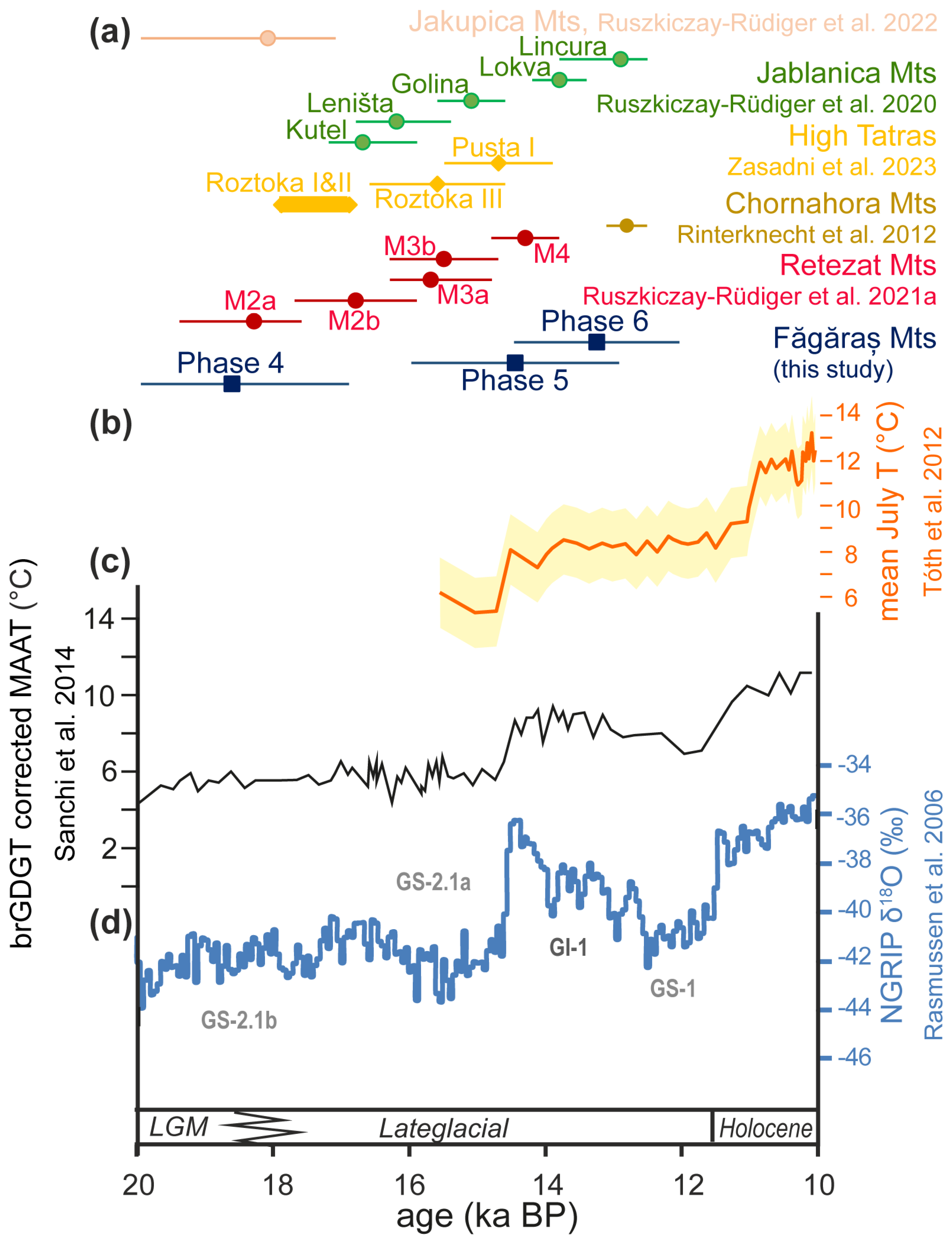
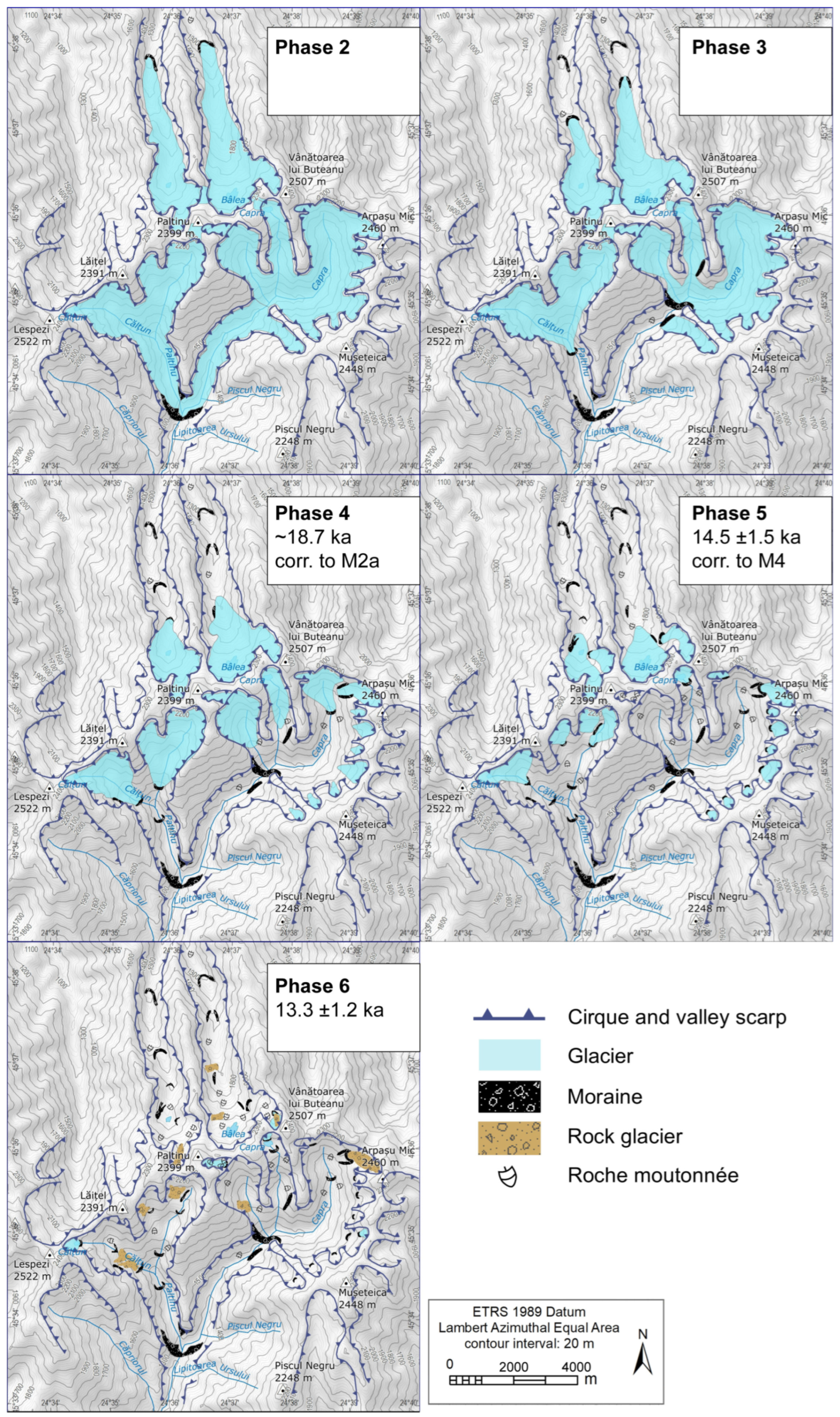
5.1. Deglaciation Chronology of the Central Făgăraș Mts and the Surrounding Alpine Ranges

The youngest CRE age (B1: 13.3 ± 1.2 ka) was obtained for the sample collected from the terminal moraine of the last glacieret of the nested cirque in the Bâlea Valley (Figure 1 and Figure 3). The highest moraines in the central Făgăraș Mts previously were attributed to the early Holocene cold spell at 8.2 ka [17] without any geochronological evidence. The first 10Be CRE age obtained from a landform belonging to this palaeoglacial phase in the Bâlea Valley does not support the Holocene stabilization; instead, it renders the final deglaciation of the central Făgăraș Mts to the late glacial period. The obtained first CRE age of Phase 6 glacial remnants is slightly younger but overlaps within uncertainty with the youngest dated glaciological stage in the Retezat Mts [18,19]. The shrunken ice bodies presumably survived owing to the favorable topoclimatic conditions at such places in the central Făgăraș Mts. However, it is also true that similarly elevated moraines have not yet been investigated in the Retezat [13,14,18], and there is possible old bias of CRE ages due to the inherited 10Be inventory, as was reported in the case of moraines from the upper cirques [19], hindering the robust CRE age estimation of these landforms.
The polished bedrock sample (F9) and the moraine boulder (F3) linked to the penultimate glacial stage defined a subsequent age cluster (Table 2). The two exposure ages are well in agreement (F3: 14.5 ± 1.5 ka and F9: 14.9 ± 1.8 ka), with a slightly older age of the striated rock surface (F9) compared to the moraine boulder (F3). We propose that the CRE age of the moraine boulder (F3: 14.5 ± 1.5 ka) could better constrain the stabilization phase of the former palaeoglacier. Previously, this glacial stage was assigned to the Greenland Stadial-1 (Younger Dryas) period [17]. Recalculated ages with a realistic snow-shielding point to earlier moraine stabilization being too old, in our view to link it to GS-1. Instead, the inferred stabilization age overlaps with the CRE age of the highest moraines and perfectly coincides with the stabilization phase of the last dated glacial stage (M4) of the Retezat Mts [19] and the rapid regional warming at the onset of Greenland Interstadial-1 (see Section 5.2.).
Coherent CRE ages were obtained from the boulders (VD4, VD5) linked to the previous glacial stage of the central Făgăraș Mts (Table 2). The ~18.7 ka stabilization again represents a perfect coincidence with a major glacier stabilization event (M2a) also dated in the nearby Retezat Mts [18,19]; however, the corresponding palaeoglaciers were more extended and deposited terminal moraines at lower elevations in that range. In addition, geomorphological and/or geochronological evidence of intermediate stages documented between M4 and M2a in the Retezat Mts [14,18,19] is still not seen in the central Făgăraş Mts, as of yet (Figure 4a). Otherwise, the coincidences between the timing of the main stages of last deglaciation in the central Făgăraş and Retezat suggest that M2a and M4 represent regionally coherent stages in the late glacial chronosequence of deglaciation history across the Southern Carpathians. Another option is that these large boulders bear inherited cosmogenic 10Be from the previous glacial phase, leading to an excess of cosmogenic 10Be in the sampled rock and thus to an old bias of the calculated exposure ages [11,19,48,49,50,51]. In such case, the glaciers belonging to the M2a phase could have been longer, which morphologically could correlate better with the glaciers reconstructed in the Retezat Mts. Further studies are needed to investigate this possibility.
All CRE ages gathered from the landforms representing the more extended glacial stages (Phases 3 and 2) in the central Făgăraş Mts are younger than expected from their morphostratigraphic position (Figure 1 and Figure 3, Table 2). The landforms of these older phases are highly degraded, which can cause the loss of surface layers containing the cosmogenic nuclide inventories accumulated from the true time of deglaciation, leading to a considerable young bias of the apparent CRE ages, which thus must be regarded as minimum age constraints [11,48,51,52]. However, considering the coherent ages of the last well-dated morphostratigraphic unit (Phase 4), it is likely that the former balanced-budget conditions which prevailed before ~19 ka in the central Făgăraş Mts coincided with the cold peaks of Marine Isotope Stage 2 (MIS 2) or even older. Radiometrically dated growth phases of speleothems in several relict alpine ridge-top caves in the Mușeteica and Râiosu cirques suggest that conditions for ice formation or advance were met ~70 ka, and conditions favoring glaciations might already have existed during the MIS 6 and MIS 8 periods in the central Făgăraș Mts [26].
A comparison of the deglaciation chronology of the Făgăraş Mts with the Parâng Mts, the third major alpine massif of the Southern Carpathians, could be also interesting; however, the currently available geochronological data provide limited insights in its glacial chronology. A pilot study reported five 10Be CRE ages ranging between 16.7 ± 1.5 and 17.9 ± 1.6 ka [15]; however, the lack of necessary field and laboratory data precludes the recalculation and the re-interpretation of these data. A subsequent study provided a larger set of 10Be CRE ages [16]. However, the dataset shows large scattering and stratigraphic contradictions. In addition, zero erosion was assumed, and snow shielding was omitted from the CRE age calculation, which leads to a considerable underestimation of the estimated CRE ages (see Section 5.3). A careful revision of the sampling sites considering their geomorphological situation and recalculation of the CRE age estimates are necessary to synthesize the available data on the deglaciation history across the Southern Carpathians.
To extend the discussion to the surrounding areas beyond the Southern Carpathians, we provide a comparison of the glacial chronologies to those of ranges with CRE dated late glacial moraines, which are (i) situated no further than ~600 km from the Făgăraş Mts and (ii) where the applied CRE calculation methodology is comparable to the approach used in this study (Lal/Stone scaling, correction for denudation and snow cover). Two ranges from the northern part of the Carpathians (Chornahora Mts [53] and High Tatras [54]) and two ranges from the Central Balkan Peninsula (Jablanica Mts [55] and Jakupica Mts [56]) met these criteria. The High Tatras was represented by the Sucha Woda and Białka Valley composite record because they constitute the key locations of deglaciation chronology in the NW part of the High Tatras, with the largest archive of published CRE ages and the best-developed, multimoraine deglaciation sequence [54].
A notable correspondence can be seen between the CRE dated stages of deglaciation of the central Făgăraş Mts and other ranges of the Carpathians and central Balkan Peninsula (Figure 4a). Phase 4 of the central Făgăraş Mts matches the beginning of the Roztoka I phase of deglaciation of the High Tatras [54] and the main CRE dated deglaciation stage of the Jakupica Mts [56]. There is a tendency toward coincidence between the Phase 5 deglaciation stage of the central Făgăraş Mts, the Pusta I stage of the High Tatras [54] and the Golina stage in the Jablanica Mts [55]. The ultimate phase of deglaciation in the central Făgăraş Mts seems to be coincident with a Late Glacial moraine deposition in the Chornahora Mts [53] and the Lincura stage in the Jablanica Mts [55]. It must be noted that the exposure ages of subsequent glacial phases frequently overlap within error, and careful investigation of their morphostratigraphic positions is needed to set up a consequent deglaciation chronology. Also, due to the relatively large uncertainties of the CRE records, we refrain from their interpretation in terms of millennial climate change events [11].

5.2. Deglaciation Chronology of the Central Făgăraș Mts—Paleoclimatological Context

Comparing the CRE age estimates of the three dated glacial stages in the central Făgăraș Mts to the regional or large-scale paleoclimate records could help to assess the palaeoclimatological context of the last deglaciation of this mountain range (Figure 4). The Greenland ice core δ18O record [57] can serve as a fundamental record for the large-scale key climatic events of the wider Euro-Atlantic realm [58]. Branched tetraether lipids from the NW Black Sea sediments [59] provided quantitative estimates for the mean surface temperature of the catchment of the NW Black Sea. Meanwhile, chironomid-based reconstruction of the July mean temperature from a lacustrine sequence of the Retezat Mts [60] can be considered an indicator of summer temperature fluctuation in the Southern Carpathian region.
Figure 4. Late Glacial moraine stabilization periods in the central Făgăraș Mts and regional palaeoclimate records. (a) Most probable age and associated uncertainty (error bars) of Late Glacial balanced-budget glacial periods in the central Făgăraș Mts (blue) and from the Retezat Mts (red) [19]; the Chornahora Mts (ochre) [53]; the High Tatras (yellow) [54]; the Jablanica Mts (green) [55], and the Jakupica Mts (pink) [56]. CRE ages were converted to the BP scale (before present, where present refer to 1950 CE) to facilitate a more accurate comparison with the other palaeoclimate records. (b) Chironomid-based reconstruction of July mean temperature from a lacustrine sequence of the Retezat Mts [60]. (c) Branched tetraether lipid-based mean annual temperature reconstruction from NW Black Sea sediments [59]. (d) Greenland ice core δ18O record and the inferred climate stratigraphy [57].
Geosciences 15 00109 g004
The oldest currently dated glacial stage at ~18.7 ka (corresponding to M2a of the Retezat) corresponds to Greenland Stadial-2 (GS-2) while glacier stabilization at ~14.5 ka (corresponding to M4 of the Retezat) followed shortly after the sharp increase in the Greenland ice core δ18O record at the onset of the Greenland Interstadial-1 (GI-1) at 14.7 ka. These correspondences suggest that large-scale warming in the Euro-Atlantic region influenced the climate of the Southern Carpathians, leading to moraine stabilization in the central Făgăraș Mts (Figure 4) and also in the Retezat Mts. Minor cooling events seen in the temperature signal of lipid-based regional temperature reconstruction during the GS-2 period indicate ~2 °C cooling of the catchment of the NW Black Sea [59]. These small-amplitude cooling events might trigger advances and stabilization of the palaeoglaciers in the Southern Carpathians including the central Făgăraș Mts in this period.
The temperature signal of branched tetraether lipids from the NW Black Sea sediments indicates ~3 °C warming of the catchment from ~15.0 to 14.5 ka [59]. The reconstructed July air temperature from the Retezat Mts [60] suggests a warming of ~2.8 °C around ~14.5 ka cal BP, at the onset of the GI-1 (Figure 4). The coincidence with this rapid warming event provides strong evidence that a major glacier recession, and abandonment of the moraines at this time, was a consequence of enhanced ablation due to regionally increasing temperature. This warming from 14.5 ka cal BP was reflected both in the geochemical signal of the Late Glacial sequence of lake sediments in the Retezat Mts [61] and the palaeovegetation records across the Southern Carpathians, indicating major forest expansion [62,63]. A pronounced shift toward a less depleted composition in a heavy stable oxygen isotope in the speleothem record from NW Romania from 14.8 to 14.4 ka also supports warming in the regional climate [64].
The last period characterized by a balanced glaciological budget in the central Făgăraș Mts might be related to the GI-1, suggested by the CRE age of 13.3 ± 1.2 ka of the B1 sample, slightly younger but overlapping previous phase (Figure 4). This period, apparently resulting in a short stabilization of the last glacierets in the study area, is mirrored neither in the current CRE database of the Retezat Mts nor in the regional or local temperature proxy records (Figure 4). Only minor cooling events (<2 °C) can be seen in the lipid-based annual mean temperature reconstruction [59], and chironomid assemblages indicate even smaller-amplitude cooling episodes in this period [60]. However, the speleothem stable isotope records from NW Romania suggest a cold/wet event around 13 ka BP in the region [64]. This could lead to positive glacial balance for a short time in the Late Glacial period before the final disappearance of glaciers from the central Făgăraș Mts.

5.3. Current Limitations and Future Works

Despite this study having doubled the number of available CRE data for the Făgăraș Mts, the sample set is still limited. More samples should be collected from each landform, and several landforms belonging to the same phase should be targeted during future sampling campaigns. A key limitation of the current dataset is that the maximum ice extent cannot be estimated due to the lack of datable landforms. Future fieldwork may identify moraine boulders in the lower part of the valleys. A promising target area for a better understanding of the deglaciation chronology is the upper part of the Dejani Valley in the eastern part of the range, where four stadial moraines situated between 1860 and 2010 m were mapped [15].
We emphasize that the influence of the CRE age calculation methodology is definitive for deriving the best estimate and comparable exposure durations from the raw isotopic data. It has been demonstrated that neglecting the proper correction factors of the 10Be production rate may lead to 5–15% (up to 20%) bias of the estimated exposure age, resulting in a 1000–2000 years younger apparent age of the dated landforms (Table 2 and Table S1). Several past and recent studies in the Southern Carpathians have overlooked the impact of surface denudation, temporal shielding (such as by snow or soil) or both [14,16,17,20]. Previous studies have demonstrated that in mountainous areas prone to considerable erosion and winter snow accumulation, like the Southern Carpathians, both factors are to be accounted for when calculating and interpreting the apparent CRE ages [11,18,19,44,47,51]. For instance, paired CRE age estimates from the NE Carpathians showed ~1 ka difference when omitting or considering denudation and snow shielding in late glacial moraines [60]. In the Retezat Mts, the effect of considering the local denudation and snow correction led to an age difference >1 ka on average, but up to 2.0–2.6 ka in the case of the samples at a high elevation [19]. Such a bias could propagate to considerable mistakes in the correlation between deglaciation chronologies and independently dated paleoenvironmental records, leading to false interpretations.

6. Conclusions

New geochronological data were produced in the current study and former data [17] recalculated to improve the chronological framework of deglaciation of the central Făgăraș Mts. The first 10Be exposure age obtained from a glacial landform representing the last glacierets of the central Făgăraş Mts was 13.5 ± 1.2 ka. The moraine assemblages providing geomorphological evidence of balanced-budget glaciological conditions were dated around 14.5 and 18.6 ka in the central Făgăraș Mts. These glacial stages are in fine agreement with CRE ages of two major stages—M4 and M2a, respectively—of the deglaciation history of the neighboring Retezat Mts. Hitherto, no evidence of a GS-1 (Younger Dryas) or Holocene glacial advance has been found in the glacial geomorphological record of the Făgăraș, similarly to the Retezat Mts.
CRE ages obtained from the landforms of the older glacial stages are apparently too young when compared to their morphostratigraphic positions. Those glacial stages presumably correspond to earlier cold glacial conditions of MIS 2, or even former glacial periods. Further data are necessary to constrain the ages of the older palaeoglaciers of the central Făgăraș Mts.
It is crucial to accurately correct the production rates for any potential factors influencing the accumulation of cosmogenic nuclides in order to obtain the most probable cosmic ray exposure (CRE) ages. Factors such as temporal shielding by snow or soil and surface denudation can reduce the CRN production rate in surface rocks. Failure to make these necessary corrections often results in significantly younger apparent CRE ages, which could bias geomorphological and palaeoclimatological interpretations.

Supplementary Materials

The following supporting information can be downloaded at https://www.mdpi.com/article/10.3390/geosciences15030109/s1, Table S1: Field, topographic and laboratory data of the samples.

Author Contributions

Conceptualization, P.U. and Z.R.-R.; Data Curation, Z.R.-R. and A.T.; Funding Acquisition, P.U. and Z.R.-R.; Investigation, Z.K., P.U., A.T. and Z.R.-R.; Methodology, Z.R.-R.; Project Administration, Z.R.-R.; Resources, P.U. and Z.R.-R.; Software, Z.R.-R.; Validation, Z.K., P.U. and Z.R.-R.; Visualization, Z.K., P.U. and M.A.; Writing—Original Draft, Z.K.; Writing—Review and Editing, P.U., M.A. and Z.R.-R. All authors have read and agreed to the published version of the manuscript.

Funding

This research was funded by the National Research, Development and Innovation Office of Hungary, grant number 124807; and by PNRR-III-C9 2022-I8, CF 253/29.11.2022 project 760055/23.05.2023 (ChronoCaRP).

Data Availability Statement

The original contributions presented in this study are included in the article/Supplementary Materials. Further inquiries can be directed to the corresponding author(s).

Acknowledgments

Thanks to the Department of Geography of WUT student team participants in the Făgăraș Mts field trip. This is contribution no. 92 of the 2 ka Palæoclimatology Research Group.

Conflicts of Interest

The authors declare no conflicts of interest.

References

  1. Lehmann, P. Beobachtungen über Tektonik und Gletscherspuren im Fogarascher Hochgebirge. Z. Dtsch. Geol. Ges. 1881, 33, 109–117. [Google Scholar]
  2. de Martonne, E. La Période Glaciaire dans les Karpates Méridionales; Imprimerie Hollinek Frères: Vienna, Austria, 1904; pp. 691–702. [Google Scholar]
  3. Posea, G. Geomorfologia României; Editura Fundaţiei România de Mâine: Bucureşti, Romania, 2002; pp. 27–40. [Google Scholar]
  4. Urdea, P. The Pleistocene glaciation of the Romanian Carpathians. In Developments in Quaternary Sciences; Ehlers, J., Gibbard, P.L., Eds.; Elsevier: Amsterdam, The Netherlands, 2004; Volume 2, pp. 301–308. [Google Scholar]
  5. Popescu, R.; Urdea, P.; Vespremeanu-Stroe, A. Deglaciation History of High Massifs from the Romanian Carpathians: Towards an Integrated View. In Landform Dynamics and Evolution in Romania; Radoane, M., Vespremeanu-Stroe, A., Eds.; Springer International Publishing: Cham, Switzerland, 2017; pp. 87–116. [Google Scholar]
  6. Kłapyta, P.; Zasadni, J.; Mîndrescu, M. Late Pleistocene glaciation in the Eastern Carpathians—A regional overview. CATENA 2023, 224, 106994. [Google Scholar] [CrossRef]
  7. Mîndrescu, M.; Evans, I.S. Cirque form and development in Romania: Allometry and the buzzsaw hypothesis. Geomorphology 2014, 208, 117–136. [Google Scholar] [CrossRef]
  8. Mîndrescu, M.; Evans, I.S.; Cox, N.J. Climatic implications of cirque distribution in the Romanian Carpathians: Palaeowind directions during glacial periods. J. Quat. Sci. 2010, 25, 875–888. [Google Scholar] [CrossRef]
  9. Urdea, P.; Onaca, A.; Ardelean, F.; Ardelean, M. Chapter 24—New Evidence on the Quaternary Glaciation in the Romanian Carpathians. In Developments in Quaternary Sciences; Ehlers, J., Gibbard, P.L., Hughes, P.D., Eds.; Elsevier: Amsterdam, The Netherlands, 2011; Volume 15, pp. 305–322. [Google Scholar]
  10. Urdea, P. Munţii Retezat: Studiu Geomorfologic; Editura Academiei Române: Bucureşti, Romania, 2000. [Google Scholar]
  11. Balco, G. Contributions and unrealized potential contributions of cosmogenic-nuclide exposure dating to glacier chronology, 1990–2010. Quat. Sci. Rev. 2011, 30, 3–27. [Google Scholar] [CrossRef]
  12. Gosse, J.C.; Phillips, F.M. Terrestrial in situ cosmogenic nuclides: Theory and application. Quat. Sci. Rev. 2001, 20, 1475–1560. [Google Scholar] [CrossRef]
  13. Reuther, A.; Geiger, C.; Urdea, P.; Niller, H.-P.; Heine, K. Determining the glacial equilibrium line altitude (ELA) for the northern Retezat Mountains, southern Carpathians and resulting paleoclimatic implications for the last glacial cycle. Analele Univ. Vest Timişoara Ser. Geogr. 2004, 14, 11–34. [Google Scholar]
  14. Reuther, A.U.; Urdea, P.; Geiger, C.; Ivy-Ochs, S.; Niller, H.-P.; Kubik, P.W.; Heine, K. Late Pleistocene glacial chronology of the Pietrele Valley, Retezat Mountains, Southern Carpathians constrained by 10Be exposure ages and pedological investigations. Quat. Int. 2007, 164–165, 1511–1569. [Google Scholar] [CrossRef]
  15. Urdea, P.; Reuther, A.U. Some new data concerning the Quaternary glaciation in the Romanian Carpathians. Geogr. Pannonica 2009, 13, 41–52. [Google Scholar] [CrossRef]
  16. Gheorghiu, D.M.; Hosu, M.; Corpade, C.; Xu, S. Deglaciation constraints in the Parâng Mountains, Southern Romania, using surface exposure dating. Quat. Int. 2015, 388, 156–167. [Google Scholar] [CrossRef]
  17. Kuhlemann, J.; Dobre, F.; Urdea, P.; Krumrei, I.; Gachev, E.; Kubik, P.; Rahn, M. Last glacial maximum glaciation of the Central South Carpathian Range (Romania). Austrian J. Earth Sci. 2013, 106, 50–62. [Google Scholar]
  18. Ruszkiczay-Rüdiger, Z.; Kern, Z.; Urdea, P.; Braucher, R.; Madarász, B.; Schimmelpfennig, I. Revised deglaciation history of the Pietrele–Stânişoara glacial complex, Retezat Mts, Southern Carpathians, Romania. Quat. Int. 2016, 415, 216–229. [Google Scholar] [CrossRef]
  19. Ruszkiczay-Rüdiger, Z.; Kern, Z.; Urdea, P.; Madarász, B.; Braucher, R. Limited glacial erosion during the last glaciation in mid-latitude cirques (Retezat Mts, Southern Carpathians, Romania). Geomorphology 2021, 384, 107719. [Google Scholar] [CrossRef]
  20. Pascal, D.; Vespremeanu-Stroe, A.; Braucher, R.; Popescu, R.; Enachescu, M.; Berbecariu, A.; Vasile, A. New Data from Făgăraș and Retezat Massifs Set the Timeframe of the Last Glacial Activity in Southern Carpathians during Younger Dryas and Early Holocene. In Proceedings of the European Geosciences Union General Assembly 2024 (EGU24), Vienna, Austria, 14–19 April 2024. [Google Scholar] [CrossRef]
  21. Borchers, B.; Marrero, S.; Balco, G.; Caffee, M.; Goehring, B.; Lifton, N.; Nishiizumi, K.; Phillips, F.; Schaefer, J.; Stone, J. Geological calibration of spallation production rates in the CRONUS-Earth project. Quat. Geochronol. 2016, 31, 188–198. [Google Scholar] [CrossRef]
  22. Chmeleff, J.; von Blanckenburg, F.; Kossert, K.; Jakob, D. Determination of the 10Be half-life by multicollector ICP-MS and liquid scintillation counting. Nucl. Instrum. Methods Phys. Res. Sect. B Beam Interact. Mater. Atoms 2010, 268, 192–199. [Google Scholar] [CrossRef]
  23. Korschinek, G.; Bergmaier, A.; Faestermann, T.; Gerstmann, U.C.; Knie, K.; Rugel, G.; Wallner, A.; Dillmann, I.; Dollinger, G.; von Gostomski, C.L.; et al. A new value for the half-life of 10Be by Heavy-Ion Elastic Recoil Detection and liquid scintillation counting. Nucl. Instrum. Methods Phys. Res. Sect. B Beam Interact. Mater. Atoms 2010, 268, 187–191. [Google Scholar] [CrossRef]
  24. Urdea, P.; Onaca, A.; Ardelean, F. Application of DC resistivity tomography on glacial deposits in the Bâlea-Valea Doamnei area, Făgăraş Mountains. Anal. Univ. Vest Timişoara Geogr. 2007, 17, 5–22. [Google Scholar]
  25. Drăgușin, V.; Mirea, I.; Nae, A.; Tîrlă, M.-L. Caves of the Făgăras Mountains. In Cave and Karst Systems of Romania; Ponta, G.M.L., Onac, B.P., Eds.; Springer International Publishing: Cham, Switzerland, 2019; pp. 79–82. [Google Scholar]
  26. Tîrlă, L.; Drăgușin, V.; Bajo, P.; Covaliov, S.; Cruceru, N.; Ersek, V.; Hanganu, D.; Hellstrom, J.; Hoffmann, D.; Mirea, I.; et al. Quaternary environmental evolution in the South Carpathians reconstructed from glaciokarst geomorphology and sedimentary archives. Geomorphology 2020, 354, 107038. [Google Scholar] [CrossRef]
  27. Onaca, A.; Ardelean, F.; Urdea, P.; Magori, B. Southern Carpathian rock glaciers: Inventory, distribution and environmental controlling factors. Geomorphology 2017, 293, 391–404. [Google Scholar] [CrossRef]
  28. Onaca, A.; Urdea, P.; Ardelean, A.C.; Șerban, R.; Ardelean, F. Present-Day Periglacial Processes in the Alpine Zone. In Landform Dynamics and Evolution in Romania; Radoane, M., Vespremeanu-Stroe, A., Eds.; Springer International Publishing: Cham, Switzerland, 2017; pp. 147–176. [Google Scholar]
  29. Vasile, M.; Vespremeanu-Stroe, A.; Pascal, D.; Braucher, R.; Pleșoianu, A.; Popescu, R.; Etzelmüller, B. Rock walls distribution and Holocene evolution in a mid-latitude mountain range (the Romanian Carpathians). Geomorphology 2022, 413, 108351. [Google Scholar] [CrossRef]
  30. Micu, D.M.; Dumitrescu, A.; Cheval, S.; Birsan, M.-V. Climate of the Romanian Carpathians; Springer: Berlin/Heidelberg, Germany, 2015. [Google Scholar]
  31. Voiculescu, M.; Ardelean, F. Snow avalanche–disturbance of high mountain environment. Case study–the Doamnei glacial valley the Făgăraş massif-Southern Carpathians, Romanian Carpathians. Carpathian J. Earth Environ. Sci. 2012, 7, 95–108. [Google Scholar]
  32. Pană, D. Central and northern Făgăraş—Lithological sequences and structure. D. S. Inst. Geol. Geofiz. 1990, 74, 81–99. [Google Scholar]
  33. Urdea, P.; Törok-Oance, M.; Ardelean, M.; Vuia, F.; Voiculescu, M.V. Geomorphological aspects of the human impact in the alpine area of Southern Carpathians (Romania). Hrvat. Geogr. Glas. 2009, 71, 19–31. [Google Scholar] [CrossRef]
  34. Hughes, P.D.; Gibbard, P.L.; Woodward, J.C. Quaternary glacial records in mountain regions: A formal stratigraphical approach. Episodes 2005, 28, 85–92. [Google Scholar] [CrossRef]
  35. Merchel, S.; Herpers, U. An Update on Radiochemical Separation Techniques for the Determination of Long-Lived Radionuclides via Accelerator Mass Spectrometry. Radiochim. Acta 1999, 84, 215–220. [Google Scholar] [CrossRef]
  36. Merchel, S.; Gärtner, A.; Beutner, S.; Bookhagen, B.; Chabilan, A. Attempts to understand potential deficiencies in chemical procedures for AMS: Cleaning and dissolving quartz for 10Be and 26Al analysis. Nucl. Instrum. Methods Phys. Res. Sect. B Beam Interact. Mater. Atoms 2019, 455, 293–299. [Google Scholar] [CrossRef]
  37. Ruszkiczay-Rüdiger, Z.; Neuhuber, S.; Braucher, R.; Lachner, J.; Steier, P.; Wieser, A.; Braun, M.; Bourlès, D.; Aumaître, G.; Keddadouche, K.; et al. Comparison and performance of two cosmogenic nuclide sample preparation procedures of in situ produced 10Be and 26Al. J. Radioanal. Nucl. Chem. 2021, 329, 1523–1536. [Google Scholar] [CrossRef]
  38. Arnold, M.; Merchel, S.; Bourlès, D.L.; Braucher, R.; Benedetti, L.; Finkel, R.C.; Aumaître, G.; Gottdang, A.; Klein, M. The French accelerator mass spectrometry facility ASTER: Improved performance and developments. Nucl. Instrum. Methods Phys. Res. Sect. B Beam Interact. Mater. Atoms 2010, 268, 1954–1959. [Google Scholar] [CrossRef]
  39. Braucher, R.; Guillou, V.; Bourlès, D.L.; Arnold, M.; Aumaître, G.; Keddadouche, K.; Nottoli, E. Preparation of ASTER in-house 10Be/9Be standard solutions. Nucl. Instrum. Methods Phys. Res. Sect. B Beam Interact. Mater. Atoms 2015, 361, 335–340. [Google Scholar] [CrossRef]
  40. Vermeesch, P. CosmoCalc: An Excel add-in for cosmogenic nuclide calculations. Geochem. Geophys. Geosyst. 2007, 8, Q08003. [Google Scholar] [CrossRef]
  41. Mațenco, L. Tectonics and exhumation of Romanian Carpathians: Inferences from kinematic and thermochronological studies. In Landform Dynamics and Evolution in Romania; Radoane, M., Vespremeanu-Stroe, A., Eds.; Springer International Publishing: Cham, Switzerland, 2017; pp. 15–56. [Google Scholar]
  42. Zugrăvescu, D.; Polonic, G.; Horomnea, M.; Dragomir, V. Recent vertical crustal movements on the Romanian territory, major tectonic compartments and their relative dynamics. Rev. Roum. Géol. Géophys. Géogr. Sér. Géogr. 1998, 42, 3–14. [Google Scholar]
  43. Plug, L.J.; Gosse, J.C.; McIntosh, J.J.; Bigley, R. Attenuation of cosmic ray flux in temperate forest. J. Geophys. Res. Earth Surf. 2007, 112, F02022. [Google Scholar] [CrossRef]
  44. Hippe, K.; Ivy-Ochs, S.; Kober, F.; Zasadni, J.; Wieler, R.; Wacker, L.; Kubik, P.W.; Schlüchter, C. Chronology of Lateglacial ice flow reorganization and deglaciation in the Gotthard Pass area, Central Swiss Alps, based on cosmogenic 10Be and in situ 14C. Quat. Geochronol. 2014, 19, 14–26. [Google Scholar] [CrossRef]
  45. Dumitrescu, A.; Birsan, M.-V.; Nita, I.-A. A Romanian daily high-resolution gridded dataset of snow depth (2005–2015). Geofizika 2017, 34, 275–295. [Google Scholar] [CrossRef]
  46. Micu, D. Snow pack in the Romanian Carpathians under changing climatic conditions. Meteorol. Atmos Phys. 2009, 105, 1–16. [Google Scholar] [CrossRef]
  47. Heyman, J.; Stroeven, A.P.; Harbor, J.M.; Caffee, M.W. Too young or too old: Evaluating cosmogenic exposure dating based on an analysis of compiled boulder exposure ages. Earth Planet. Sci. Lett. 2011, 302, 71–80. [Google Scholar] [CrossRef]
  48. Applegate, P.J.; Urban, N.M.; Keller, K.; Lowell, T.V.; Laabs, B.J.C.; Kelly, M.A.; Alley, R.B. Improved moraine age interpretations through explicit matching of geomorphic process models to cosmogenic nuclide measurements from single landforms. Quat. Res. 2012, 77, 293–304. [Google Scholar] [CrossRef]
  49. Crest, Y.; Delmas, M.; Braucher, R.; Gunnell, Y.; Calvet, M. Cirques have growth spurts during deglacial and interglacial periods: Evidence from 10Be and 26Al nuclide inventories in the central and eastern Pyrenees. Geomorphology 2017, 278, 60–77. [Google Scholar] [CrossRef]
  50. Wirsig, C.; Ivy-Ochs, S.; Reitner, J.M.; Christl, M.; Vockenhuber, C.; Bichler, M.; Reindl, M. Subglacial abrasion rates at Goldbergkees, Hohe Tauern, Austria, determined from cosmogenic 10Be and 36Cl concentrations. Earth Surf. Process. Landf. 2017, 42, 1119–1131. [Google Scholar] [CrossRef]
  51. Balco, G. Glacier Change and Paleoclimate Applications of Cosmogenic-Nuclide Exposure Dating. Annu. Rev. Earth Planet. Sci. 2020, 48, 21–48. [Google Scholar] [CrossRef]
  52. Zasadni, J.; Kałuża, P.; Kłapyta, P.; Świąder, A. Evolution of the Białka valley Pleistocene moraine complex in the High Tatra Mountains. CATENA 2021, 207, 105704. [Google Scholar] [CrossRef]
  53. Rinterknecht, V.; Matoshko, A.; Gorokhovich, Y.; Fabel, D.; Xu, S. Expression of the Younger Dryas cold event in the Carpathian Mountains, Ukraine? Quat. Sci. Rev. 2012, 39, 106–114. [Google Scholar] [CrossRef]
  54. Zasadni, J.; Kłapyta, P.; Makos, M. The evolution of glacial landforms in the Tatra Mountains during the deglaciation. In European Glacial Landscapes; Palacios, D., Ed.; Elsevier: Amsterdam, The Netherlands, 2023; pp. 157–164. [Google Scholar]
  55. Ruszkiczay-Rüdiger, Z.; Kern, Z.; Temovski, M.; Madarász, B.; Milevski, I.; Braucher, R.; ASTER Team. Last deglaciation in the central Balkan Peninsula: Geochronological evidence from Jablanica Mt (North Macedonia). Geomorphology 2020, 351, 106985. [Google Scholar] [CrossRef]
  56. Ruszkiczay-Rüdiger, Z.; Temovski, M.; Kern, Z.; Madarász, B.; Milevski, I.; Lachner, J.; Steier, P. Late Pleistocene glacial advances, equilibrium-line altitude changes and paleoclimate in the Jakupica Mt. (North Macedonia). CATENA 2022, 216 Pt A, 106383. [Google Scholar] [CrossRef]
  57. Rasmussen, S.O.; Bigler, M.; Blockley, S.P.; Blunier, T.; Buchardt, S.L.; Clausen, H.B.; Cvijanovic, I.; Dahl-Jensen, D.; Johnsen, S.J.; Fischer, H.; et al. A stratigraphic framework for abrupt climatic changes during the Last Glacial period based on three synchronized Greenland ice-core records: Refining and extending the INTIMATE event stratigraphy. Quat. Sci. Rev. 2014, 106, 14–28. [Google Scholar] [CrossRef]
  58. Lowe, J.J.; Rasmussen, S.O.; Björck, S.; Hoek, W.Z.; Steffensen, J.P.; Walker, M.J.C.; Yu, Z.C. Synchronisation of palaeoenvironmental events in the North Atlantic region during the Last Termination: A revised protocol recommended by the INTIMATE group. Quat. Sci. Rev. 2008, 27, 6–17. [Google Scholar] [CrossRef]
  59. Sanchi, L.; Ménot, G.; Bard, E. Insights into continental temperatures in the northwestern Black Sea area during the Last Glacial period using branched tetraether lipids. Quat. Sci. Rev. 2014, 84, 98–108. [Google Scholar] [CrossRef]
  60. Tóth, M.; Magyari, E.K.; Brooks, S.J.; Braun, M.; Buczkó, K.; Bálint, M.; Heiri, O. A chironomid-based reconstruction of Late glacial summer temperatures in the southern Carpathians (Romania). Quat. Res. 2012, 77, 122–131. [Google Scholar] [CrossRef]
  61. Braun, M.; Hubay, K.; Magyari, E.; Veres, D.; Papp, I.; Bálint, M. Using linear discriminant analysis (LDA) of bulk lake sediment geochemical data to reconstruct Lateglacial climate changes in the South Carpathian Mountains. Quat. Int. 2013, 293, 114–122. [Google Scholar] [CrossRef]
  62. Tantau, I.; Reille, M.; de Beaulieu, J.-L.; Farcas, S. Late Glacial and Holocene vegetation history in the southern part of Transylvania (Romania): Pollen analysis of two sequences from Avrig. J. Quat. Sci. 2006, 21, 49–61. [Google Scholar] [CrossRef]
  63. Magyari, E.K.; Jakab, G.; Bálint, M.; Kern, Z.; Buczkó, K.; Braun, M. Rapid vegetation response to Lateglacial and early Holocene climatic fluctuation in the South Carpathian Mountains (Romania). Quat. Sci. Rev. 2012, 35, 116–130. [Google Scholar] [CrossRef]
  64. Tămaş, T.; Onac, B.P.; Bojar, A.-V. Lateglacial-Middle Holocene stable isotope records in two coeval stalagmites from the Bihor Mountains, NW Romania. Geol. Q. 2005, 49, 185–194. [Google Scholar]
Figure 1. Mapped glacial landforms of the central Făgăraș Mts with sampling sites. Sampling spots of the current study (red star) and from a former study [17] (red triangle) are marked. The position of the central Făgăraș Mts in Romania is marked by the red square in the inset map.
Geosciences 15 00109 g001
Figure 2. Photos of the sampled boulders and bedrock surface with the sample code and the estimated CRE age with external uncertainties. (A) polished rock surface providing VD7 sample, (B) erratic boulder providing VD4 sample, (C) erratic boulder providing VD5 sample, (D) solitary boulder providing VD3 sample, (E) morainic boulder providing B1 sample.
Geosciences 15 00109 g002
Figure 3. Reconstructed glacier extents during the phases of the last deglaciation in the central Făgăraș Mts. Inferred CRE ages of the last three phases are indicated. The assumed correspondence of Phase 4 and Phase 5 to the major glaciochronological stages of the Retezat Mts is also marked in the corresponding panels.
Geosciences 15 00109 g003
Table 1. Sample data for cosmogenic 10Be exposure age determination. Samples F1 to F11 are from Kuhlemann et al. [17]; for these samples, thickness and boulder size data are estimated based on descriptions from the cited publication. For more sample data, refer to Table S1.
Sample IDLatitude
(N°)
Longitude
(E°)
Elevation
(m, asl)
Thickness
(cm)
Boulder Size (m)ValleyMorphostrat
LengthWidthHeight
VD345.604724.59891877443.53.5DoamneiPhase 5
VD445.606924.59921860322.51.5DoamneiPhase 4
VD524.599445.60921830322.51DoamneiPhase 4
VD745.624724.593314723striated bedrock~0.1DoamneiPhase 2
B145.605624.62892280322.51BâleaPhase 6
F145.5524.6013063NANA1.5CapreiPhase 2
F345.6024.6520633NANA1.5CapreiPhase 5
F545.5824.6316103NANA1.2CapreiPhase 3
F945.6024.6120653striated bedrock0.1DoamneiPhase 5/6
F1145.6224.6016703striated bedrock0.1DoamneiPhase 2
Table 2. Measured 10Be concentrations and calculated surface exposure ages. The measured 10Be/9Be AMS ratios were corrected for a full processed blank ratio of (4.177 ± 0.916) × 10−15. Age uncertainties are reported as external uncertainties (analytical, half-life and production rate). All exposure ages are corrected for topographic and self-shielding. * Corrected also for denudation, uplift and snow shielding. For correction factors used for the age calculation, refer to Section 3.3 and Table S1. The exposure durations calculated using all corrections are accepted and discussed by this study.
SubsetSample IDExposure Age (ka)
Blank Corrected
10Be Concentration
(at/grSiO2)
Basic Correction
(Minimum Age)
All Corrections *
(Most Probable Age)
this studyVD3132,848 ± 56157.9 ± 0.78.7 ± 0.8
VD4266,830 ± 10,90915.8 ± 1.518.7 ± 1.7
VD5255,287 ± 983715.8 ± 1.418.6 ± 1.7
VD7184,683 ± 748515.7 ± 1.417.2 ± 1.6
B1224,906 ± 871711.2 ± 1.013.3 ± 1.2
recalculated from Kuhlemann et al. [17]F1167,900 ± 13,93614.6 ± 1.716.5 ± 1.9
F3232,600 ± 15,11911.7 ± 1.214.5 ± 1.5
F5186,500 ± 11,00413.2 ± 1.316.0 ± 1.6
F9234,100 ± 19,89912.0 ± 1.414.9 ± 1.8
F11138,300 ± 829811.6 ± 1.213.3 ± 1.4
Disclaimer/Publisher’s Note: The statements, opinions and data contained in all publications are solely those of the individual author(s) and contributor(s) and not of MDPI and/or the editor(s). MDPI and/or the editor(s) disclaim responsibility for any injury to people or property resulting from any ideas, methods, instructions or products referred to in the content.

