Review

Geological and Geographical Characteristics of Limestone and Karst Landforms in Japan: Insights from Akiyoshidai, Seiyo (Shikoku), and Okinoerabu Island

1
Yamaguchi University Community Future Center, 2-16-1 Tokiwadai, Ube, Yamaguchi 755-8611, Japan
2
Tourism Promotion Division, Mine City Government, Mine 759-2292, Japan
3
Graduate School of Science and Technology for Innovation, Yamaguchi University, 2-16-1 Tokiwadai, Ube, Yamaguchi 755-8611, Japan
4
Department of Environmental Science, International College of Arts and Science, Fukuoka Wemen’s University, 1-1-1, Kasumigaoka, Higashi-ku, Fukuoka 813-8529, Japan
*
Author to whom correspondence should be addressed.
Geosciences 2025, 15(10), 393; https://doi.org/10.3390/geosciences15100393
Submission received: 31 August 2025 / Revised: 25 September 2025 / Accepted: 27 September 2025 / Published: 11 October 2025

Abstract

Limestone in Japan exhibits distinct distribution patterns and associated lithologies compared to limestone found in most other parts of the world. These differences reflect contrasting depositional settings and formation processes. While the majority of the world’s limestones originate from reefs and their detritus deposited on continental shelves adjacent to continents, most limestones in Japan are derived from atoll reefs formed on oceanic island basalts. The remainder developed as reefs and associated detritus along the margins of island arcs underlain by continental crust. In this study, we refer to the former as Accreted Oceanic Reef (AOR) Limestones and the latter as Autochthonous Arc-Shelf (AAS) Limestones. These two types not only differ in origin and depositional environment, but also in the development of karst landforms, including cave systems. AOR Limestones, typified by the Akiyoshi Limestone of Akiyoshidai and the Shikoku Karst, partly distributed in Seiyo (Shikoku), and Pre-Cenozoic AAS Limestones such as Torinosu Limestone of Seiyo (Shikoku) exhibit complex three-dimensional structures that contrast with various caves common worldwide. In contrast, Cenozoic AAS Limestones are exemplified by the Pleistocene Ryukyu Limestone of Okinoerabu Island, where caves, though relatively small, develop parallel to bedding planes. While differing in scale from many caves worldwide, their fundamental structures are comparable. These contrasting characteristics provide new insights into the geological and geomorphological diversity of limestone and karst landforms in Japan.

Graphical Abstract

1. Introduction

The development of karst landforms and cave systems is generally linked to platform carbonates deposited along passive continental margins, where extensive, thick sequences of limestone prevail. These limestones, widely distributed across Europe, North America, and Southeast Asia, represent geologically stable and stratigraphically well-defined successions favorable for the development of extensive groundwater systems and cave networks [1,2,3,4,5,6]. In contrast, well-developed karst has formed on oceanic islands and island arcs, such as the Hawaiian Islands and Guam in the Pacific Ocean, Christmas Island in the Indian Ocean, and the Turks and Caicos Islands and Barbados in the Atlantic Ocean [7,8,9,10,11,12,13,14], and these have been synthesized as the Carbonate Island Karst Model [15,16,17]. Similar karst landforms and cave systems are present in the Ryukyu Islands of southwestern Japan. Furthermore, most of the Paleozoic to Mesozoic limestones distributed in Japan also originated from atoll reefs [18], either fringing volcanic islands and seamounts on oceanic plates or forming along island-arc margins underlain by continental crust, as in the latter case. However, the Paleozoic to Mesozoic limestones of Japan have undergone significant structural deformation at convergent plate boundaries after their formation.
These differences in origin and tectonic history strongly influence the development and morphology of karst landforms and cave systems across Japan. For example, limestones incorporated within accretionary complexes often show karstification strongly controlled by folding and faulting, as seen in areas such as the Akiyoshi Limestone of Akiyoshidai and the Shikoku Karst, partly distributed in Seiyo (Shikoku), i.e. Seiyo City, Ehime Prefecture in Shikoku Island. In contrast, karst development in uplifted reef limestones tends to be closely aligned with their original sedimentary structures, such as those found in the Ryukyu Limestone of Okinoerabu Island.
Although limestones and karst are globally widespread, their geological settings in the Japanese Islands differ markedly from those of the large continental carbonate platforms that dominate the global record. Despite abundant local studies on individual limestone bodies, no comprehensive synthesis has clarified the nationwide characteristics of limestones and karst in Japan within a global context. This study therefore addresses the following questions:
  • How can limestones in Japan be systematically classified in terms of their tectonic and depositional settings?
  • In what ways do these limestones and their associated karst landscapes differ from those formed on continental shelves worldwide?
  • What do these differences imply for understanding the geological evolution of the Japanese Islands and for global comparisons of carbonate systems?
This paper aims to provide a comprehensive overview of the geological characteristics of limestones in Japan, focusing particularly on their structural settings, depositional origins, and stratigraphic features. Representative examples of karst landforms and cave systems will be examined to elucidate the genetic factors underlying their distinctive development. While not exhaustive, these case studies highlight the unique karstic features shaped by Japan’s complex geological background. By situating Japanese karst landscapes within the global framework of carbonate geology, this study seeks to advance understanding of karst evolution in active island arc settings and demonstrate the diverse geological pathways leading to limestone landscape formation.

2. Methodology

This study is based on a comprehensive synthesis of geological and speleological data concerning limestones and karst landscapes in Japan, supplemented by detailed regional stratigraphic and tectonic information. The primary sources include published research papers both in Japan and abroad, as well as locally circulated reports that are often difficult to access. Many of these reports contain valuable results from cave surveys and speleogenetic studies, but they are largely unavailable outside Japan and are written predominantly in Japanese, making them difficult for international readers to utilize. In addition, descriptions of cave systems in this study incorporate extensive first-hand knowledge accumulated over many years of field investigations by two of the authors (Murakami and Urata).
The analysis proceeded in three steps. First, limestone occurrences were catalogued nationwide, with attention to their age, lithofacies, and tectonic settings. Each body was assigned to one of several broad geological frameworks, including Paleozoic–Mesozoic accretionary complexes, island-arc margin deposits, and Quaternary reef complexes. Second, associated karst morphologies and cave systems were systematically compiled from cave maps, geomorphological surveys, and speleogenetic literature. These data were re-evaluated in relation to the stratigraphic and structural characteristics of the host limestone, allowing assessment of the extent to which cave development reflects lithological properties versus tectonic history.
Third, the Japanese dataset was compared with global analogues. In particular, contrasts were drawn with karst landscapes developed on extensive continental-shelf carbonate platforms (e.g., Europe, North America, Southeast Asia). This comparative framework emphasized differences in scale, structural control, and evolutionary trajectories, highlighting the uniqueness of Japanese karst within an accretionary or island-arc setting.
The temporal scope of this study spans limestones from the Paleozoic through the Quaternary, while the spatial scope encompasses the entire Japanese archipelago. Although the analysis relies primarily on published data rather than new field investigations, the systematic compilation and cross-comparison of disparate sources provide a robust framework for identifying national-scale patterns and their global implications.
This integrative methodology provides the foundation for the main body of this paper, which presents (i) a systematic characterization of limestones in Japan in terms of classification, stratigraphy, and structural setting, and (ii) a comparative analysis of karst landforms and cave systems that have developed within these unique geological contexts.

3. Results 1: Major Limestone Types in Japan

3.1. Proposal of New Terms on Limestone Classification Based on the Depositional Position and Environment

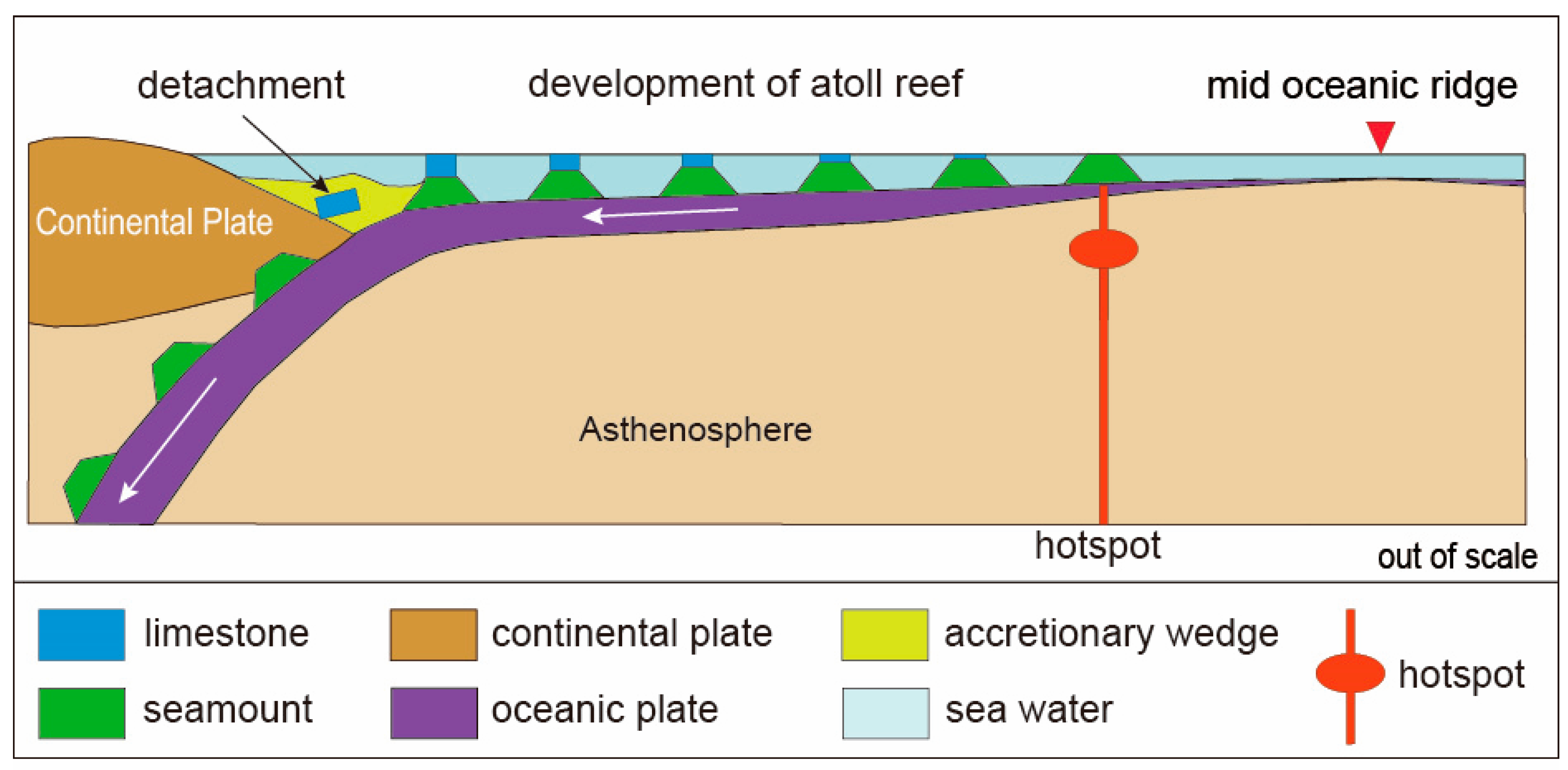
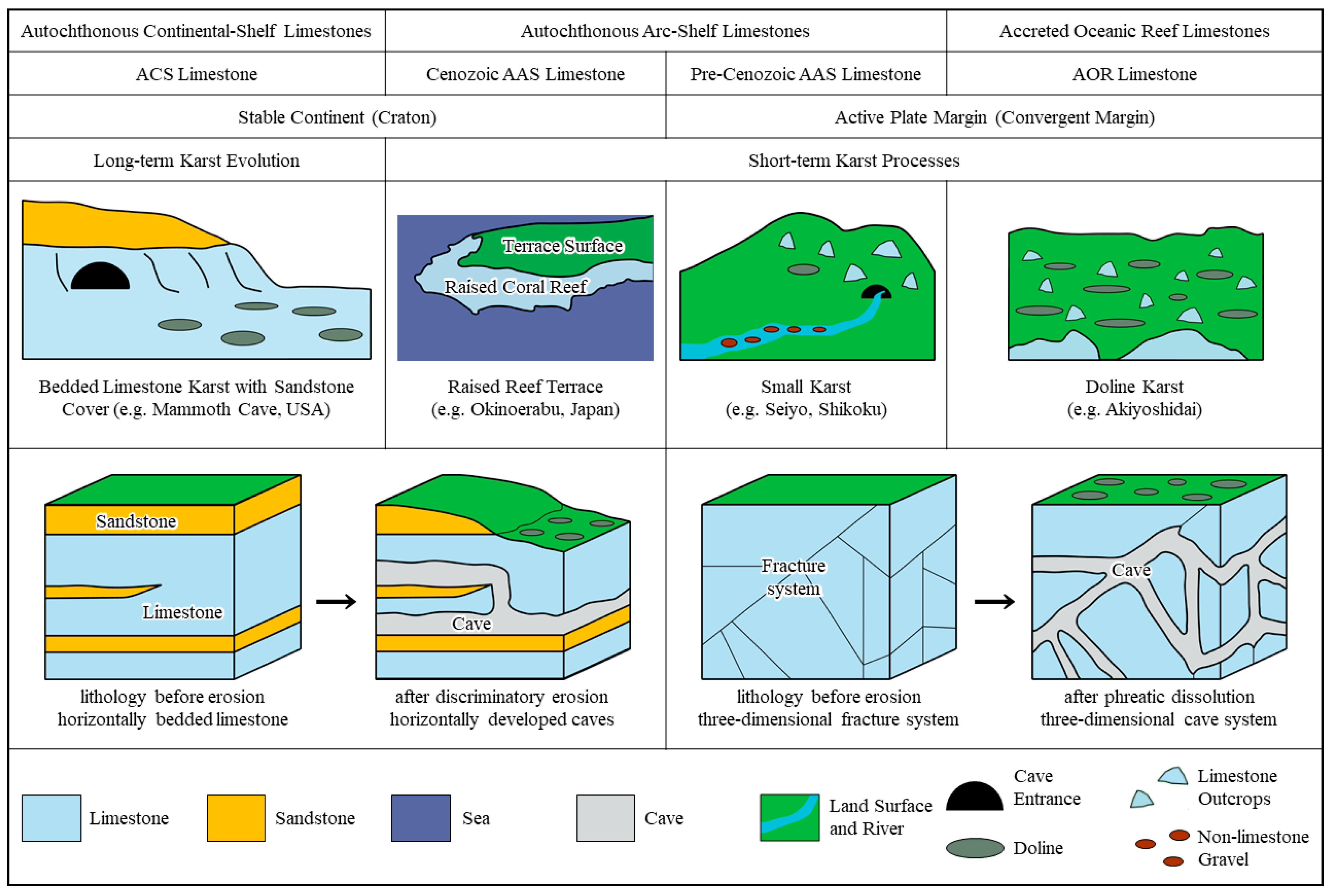
In order to elucidate the characteristics of limestones in Japan, this study introduces a classification framework that categorizes limestones in both Japan and other regions of the world into three principal types, based on their respective tectonic settings and depositional environments. These classification terms are employed consistently throughout the paper to underscore the distinctive features of limestones in Japan and to enable systematic global comparisons. The depositional environments associated with these three limestone types are presented in Figure 1.
(1) Accreted Oceanic Reef (AOR) Limestones
AOR Limestones were derived from atoll reef complexes originally formed atop oceanic seamounts, typically associated with hotspot volcanism. These carbonate bodies were subsequently detached from their original settings, transported by plate motion, and tectonically accreted onto continental margins as allochthonous blocks, commonly embedded within a mélange matrix. Due to their development on isolated and subsiding seamounts, AOR Limestones are generally small in areal extent. The depositional environment was pelagic and far from any continental source, resulting in relatively pure limestones with minimal or no input of terrigenous clastic materials.
(2) Autochthonous Arc-Shelf (AAS) Limestones
AAS Limestones were formed in situ on shallow-marine carbonate platforms developed along island arcs underlain by continental crust. These limestones remain in their original stratigraphic and tectonic positions and are typically associated with arc-related volcanic and sedimentary successions. Although larger than AOR Limestones, formations containing AAS Limestones are very limited in lateral extent compared to continental-shelf limestones. Terrigenous clastic sediments derived from adjacent volcanic arcs are often intercalated with the carbonate layers, reflecting the proximity of landmasses and active sediment supply.
(3) Autochthonous Continental-Shelf (ACS) Limestones
ACS Limestones represent widespread, relatively undeformed carbonate sequences formed on stable continental shelves or cratonic platforms. These limestones, which dominate global carbonate successions, typically display extensive lateral continuity and minimal tectonic disruption. They are commonly interbedded with terrigenous clastic sediments derived from continental sources, reflecting their depositional setting adjacent to large, stable landmasses with active sediment influx.

3.2. Geological Characteristics of Limestone in Japan

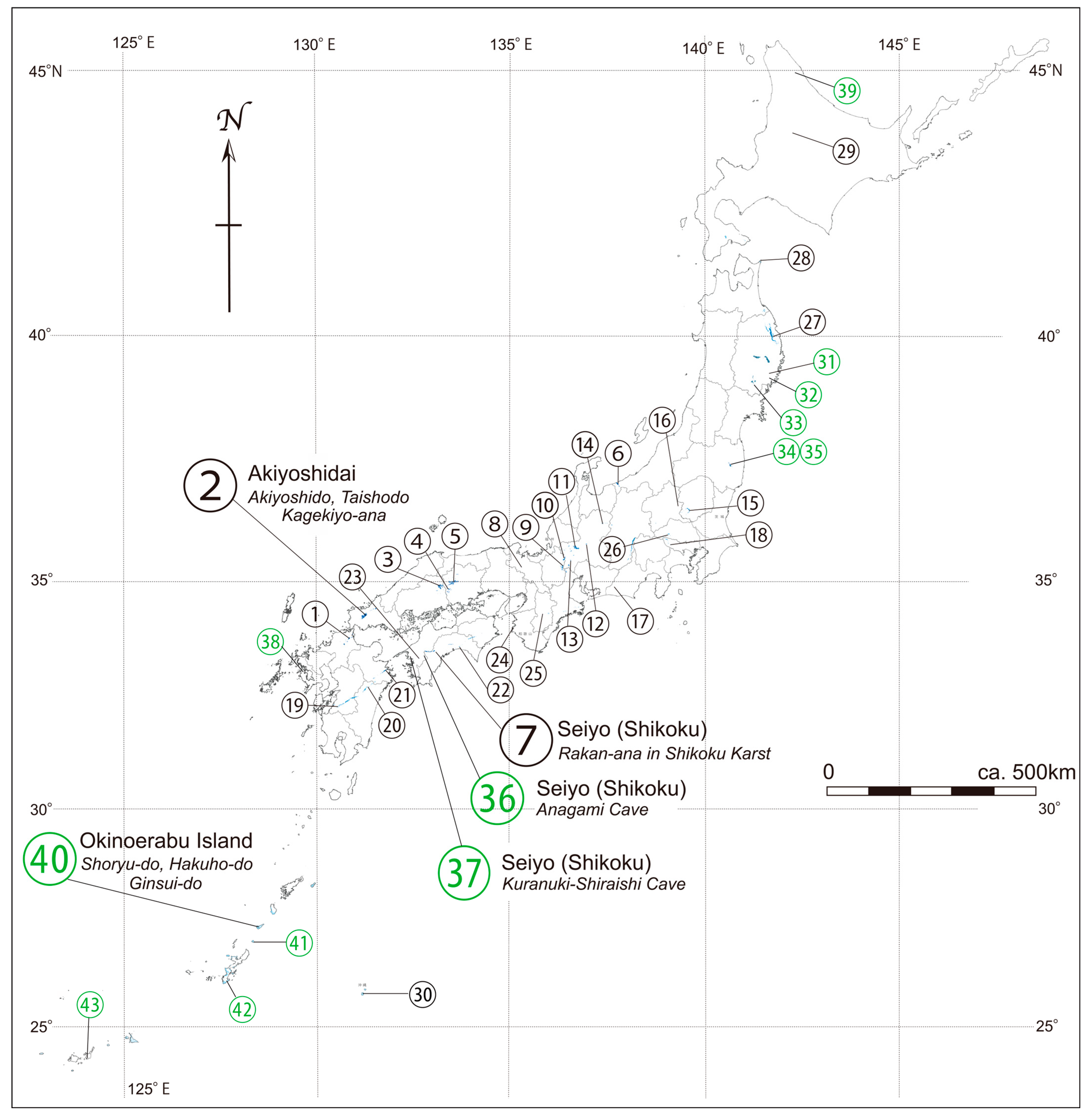
Limestones in Japan can be broadly categorized into two principal types: Accreted Oceanic Reef (AOR) Limestones and Autochthonous Arc-Shelf (AAS) Limestones (Figure 2, Table 1 and Table 2).
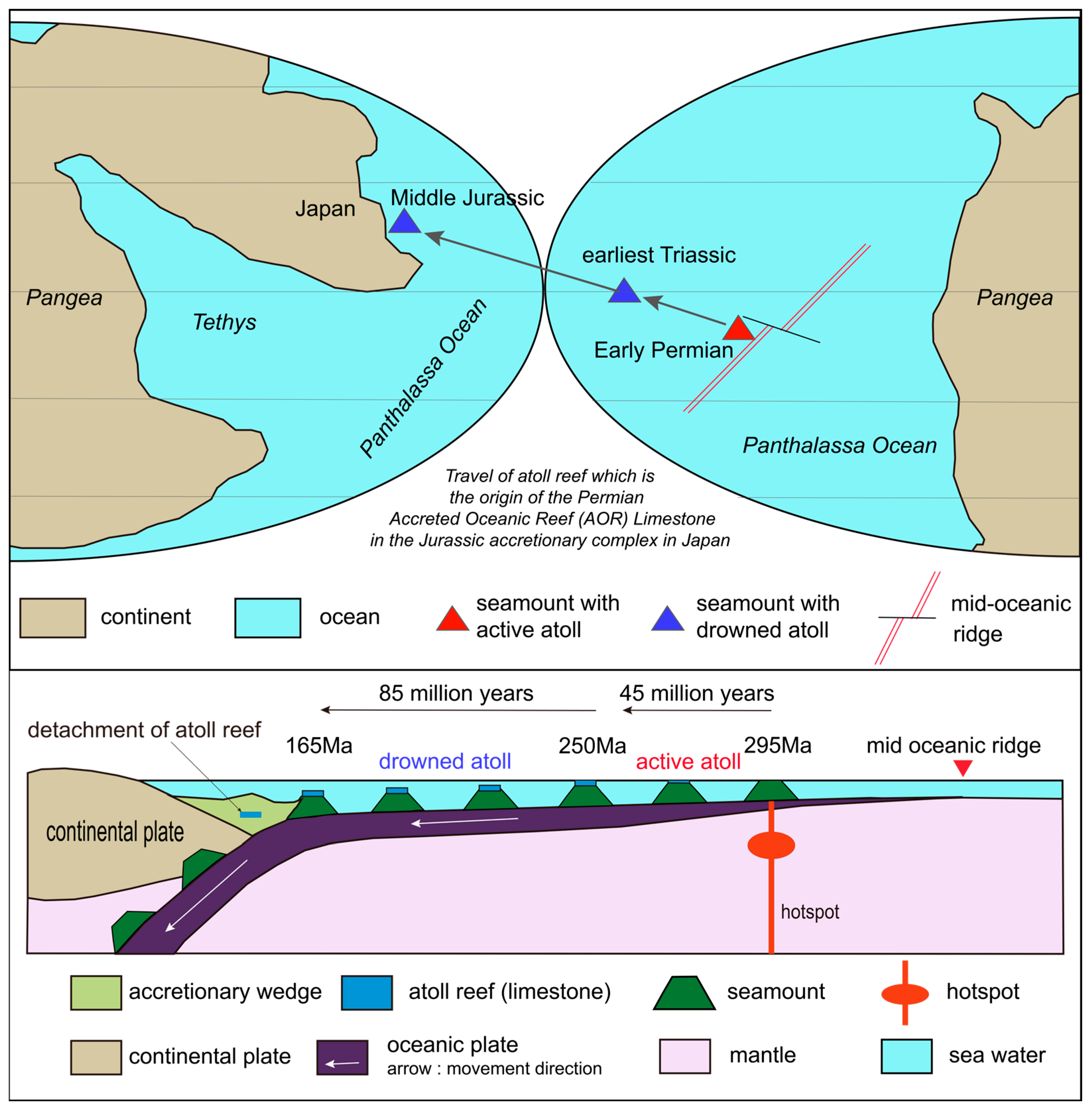
Most of the major limestone bodies in Japan are classified as AOR Limestones (Figure 3). These deposits, except for limestone of the Daito Formation, represent reef systems that developed atop volcanic edifices formed in the middle of the Panthalassa Ocean—analogous to modern reef growth on the Hawaiian volcanic islands—where wave erosion flattened the volcanic summits, allowing reef development. As oceanic plates migrated, the reef-capped seamounts were transported across the ocean and, during subduction, were accreted along with terrigenous sediments to island arcs or continental margins, forming substantial limestone bodies [18,19]. These limestones are invariably underlain by basalt of hotspot origin, and their defining characteristic is formation on oceanic plates. Throughout this paper, they are referred to as AOR Limestones. This chapter mainly describes the stratigraphy and lithofacies of AOR Limestones accreted during the Permian and from Jurassic to earliest Cretaceous.
In contrast, AAS Limestones, formed on the surrounding shelves of island arcs, are quantitatively less abundant and generally smaller in scale than the limestones found within accretionary complexes. These originated as reef deposits in shallow, warm marine environments around island arcs. Examples of AAS Limestones include Paleozoic limestone formations in the Southern Kitakami belt and the Kurosegawa belt, the Jurassic Torinosu and the Pleistocene Ryukyu Group in Okinawa Prefecture (Table 2).

3.3. Accreted Oceanic Reef (AOR) Limestones

Representative of AOR Limestones incorporated into Permian accretionary complexes include the Akiyoshi, Hiraodai, Taishaku, Atetsu, and Ōmi limestones in the Akiyoshi belt. These limestones originated from atoll reefs that developed atop submarine volcanoes erupted during Early Carboniferous period. These limestones were formed almost continuously from Early Carboniferous to Middle Permian and were accreted at subduction zones during Middle Permian. This chronology is evidenced by fusulinacean biostratigraphy.
Jurassic accretionary complexes are generally considered to have formed from Early Jurassic to earliest Cretaceous periods. However, based on the characteristics of the limestones, this paper categorizes them into two groups: narrowly defined Jurassic accretionary complexes formed from the Early to Late Jurassic, and earliest Cretaceous accretionary complexes formed during the earliest Cretaceous period. The former contains atoll-derived limestones formed from the Early to Late Permian and constitutes parts of the Mino-Tamba, Ashio, Chichibu, and northern Kitakami belts. The latter includes limestones ranging from the Early Permian to the Triassic periods and forms parts of the Sambosan belt and sections of the Northern Kitakami belt. While Cretaceous to Paleogene accretionary complexes rarely contain limestones, the Toma Limestone is one of the Permian to Triassic limestone blocks in the mélanges of the Late Cretaceous to Paleogene accretionary complex of the Hidaka belt [20,21].

3.3.1. AOR Limestones in the Permian Accretionary Complex: 1. Akiyoshi Limestone

Among the AOR Limestones in Permian accretionary complexes, the origin and formation processes are most clearly understood for the Akiyoshi Limestone of Akiyoshidai in the Akiyoshi belt [18]. The Akiyoshi Limestone originated from an atoll that developed atop a seamount, which was formed by submarine volcanism around the central Panthalassa Ocean during Early Carboniferous (ca. 340 Ma), as the volcanic edifice cooled and eroded [22,23,24,25]. As the oceanic plate cooled and subsided, the summit of the seamount gradually sank, but the atoll continued to grow upward, maintaining its position near the photic zone.
The oceanic plate, carrying the atoll-topped seamount, drifted across the floor of the Panthalassa Ocean from Early Carboniferous to Middle Permian, eventually subducting into the mantle at a trench during Middle Permian [18]. During subduction, a décollement developed between seamount and trench-fill sediments, causing much of the atoll to be detached from its basaltic basement. The detached atoll, together with pelagic chert and trench-deposited turbidites, was transformed into limestone within an accretionary complex and ultimately became part of the continental crust.
The volcanic basement of the atoll reef that gave rise to the Akiyoshi Limestone is geochemically interpreted as hotspot-derived [26,27,28], and like the Hawaiian Islands, the moving plate produced a chain of seamounts, each capped with an atoll. These atolls were accreted at different locations along the trench during the Middle Permian, and now correspond to the Hiraodai Limestone (marble) in Fukuoka Prefecture, the Taishaku Limestone in Hiroshima Prefecture [29], the Atetsu Limestone in Okayama Prefecture [30,31], the Kōyama, Nakamura, and Shimotani Limestones in Ōgadai, Okayama Prefecture [32,33,34], the Ōnogahara–Torigatayama Limestone of the Shikoku Karst in Shikoku Island [35,36,37], and the Ōmi Limestone in Niigata Prefecture [38,39] (Figure 2, Table 1).
The Akiyoshi Limestone directly overlies basaltic rocks of oceanic origin, as indicated by geochemical analyses [26,27,28]. Its basal part contains Early Carboniferous rugose corals and bryozoans [40], and it yields abundant reef-building organisms from Early Carboniferous to Middle Permian. These include fusulinid fossils, for which biostratigraphy is well established, as well as corals, sponges, crinoids, bryozoans, and microbial encrusters such as cyanobacteria. The reconstructed stratigraphic thickness is estimated to be approximately 1000 m [40].
The seamount, on which the Akiyoshi Limestone was formed, located in the central Panthalassa Ocean, gradually subsided with the cooling plate, but the atoll continued vertical growth over about 80 million years, eventually being detached at a trench and accreted along an island arc margin together with terrigenous sediments [18,19]. Many Carboniferous–Permian AOR Limestones found in Permian accretionary complexes are believed to have followed a similar geologic history to the Akiyoshi Limestone. Because these limestones remained near sea level until shortly before trench subduction, the accretionary complex was uplifted by the subduction of seamounts with reliefs of several thousand meters, forming forearc basins in front of them. The Tsunemori Formation consists of deposits of forearc basin or slope basin origin [41]. Representative stratigraphic columns of Permian accretionary complex limestones are shown in Figure 4.

3.3.2. AOR Limestones in the Permian Accretionary Complex: 2. Shikoku Karst

The Ōnogahara-Torigatayama Limestone in Ehime and Kochi Prefectures, Shikoku, forming the bedrock of the Shikoku Karst, is regarded as a Permian accretionary complex belonging to the same accretionary complex of the Akiyoshi belt as the Akiyoshi Limestone [41,42], and is assigned to the Sawadani unit of the Chichibu belt [43]. The Ōnogahara-Torigatayama Limestone is underlain by basaltic pillow lava, hyaloclastite, and basaltic breccia. Based on its petrographic characteristics, the basalt is alkali basalt, and its geochemical features suggest similarity to basalts of continental-margin or back-arc origin [44]. The limestone is a pure carbonate without terrigenous particles, exhibiting white to light gray coloration. Fusulinids of Early to Middle Permian age have been reported from the limestone [36,45,46,47,48,49,50].
Around the Ōnogahara-Torigatayama Limestone occur mudstone, sandstone, chert, basalt, and mélange. Small limestone bodies also occur as blocks within the surrounding muddy matrix. These relationships indicate that the Ōnogahara-Torigatayama Limestone body represents a giant block within a pelagic mélange. The limestone mass forms an overall south-convex arcuate distribution. Detailed tracing of the Ōnogahara-Torigatayama Limestone reveals that, from east to west, it is divided into six separate masses, most of which show a south-convex arcuate distribution [42]. Given that the limestone bodies generally dip northward and are normally northward-facing [51,52], some of the individual masses partly overlap in distribution.
From zircon in acidic tuff intercalated within mudstone around the Ōnogahara-Torigatayama Limestone, a U–Pb age of 243.5 ± 4.6 Ma has been obtained [53]. In the Jiyoshi region, coarse clastic rocks containing giant limestone boulders interpreted as derived from the Ōnogahara-Torigatayama Limestone yield U–Pb ages of 257.0 ± 4.69 Ma and 260.7 ± 2.8 Ma [53]. These data suggest that the Ōnogahara-Torigatayama Limestone approached a trench and underwent collapse to form conglomerates between 257 and 260 Ma. Taken together, the evidence indicates that, similar to the Akiyoshi Limestone, the Ōnogahara-Torigatayama Limestone formed as reefal limestone atop an oceanic seamount on a pelagic oceanic plate, and that it was accreted to the continental plate between 260 and 243 Ma.
In the Ōnogahara area, mudstone occurs between limestone bodies, which are fragmented into multiple blocks. The cleavage in the mudstone dips gently eastward or northward. The contacts between the limestone and the surrounding mudstone are inferred to be high-angle north-dipping faults.

3.3.3. AOR Limestones in the Jurassic Accretionary Complex

The Jurassic accretionary complex contains Permian AOR Limestones as allochthonous blocks and was formed along the continental margin of the South China Block from the Early to Late Jurassic. Numerous studies have been conducted on these complexes (e.g., [19,54,55,56,57,58]. Among the various basement units of Japan, Jurassic accretionary complexes are the most widely distributed and are found in geological belts such as the Mino, Tamba, Ashio, Northern Kitakami, and Chichibu belts [19,55,56,57].
The Mino belt, which is widely distributed in central Japan, is primarily composed of Jurassic accretionary complexes [55,56]. These Jurassic complexes were intruded by Late Cretaceous granites and unconformably overlain by felsic volcanic and pyroclastic rocks of Late Cretaceous. In the western part of the Mino belt, the Jurassic accretionary complex is subdivided into six geological units based on lithofacies and geologic age. From north to south, these units are the Sakamoto-tōge unit, Samondake unit, Funafuseyama unit, Nabi unit, Kanayama unit, and Kamiasō unit [56,59].
These units all consist of oceanic plate stratigraphy composed of limestone, basalt, chert, siliceous mudstone, and turbidite [56,57]. Within fault-bounded blocks, these lithologies occur in stratigraphic order as coherent facies. In contrast, the mélange facies is characterized by tectonic blocks of limestone, basalt, chert, siliceous mudstone, and sandstone embedded in a highly sheared, muddy matrix. Among these, the Samondake, Nabi, and Kamiasō units are characterized by coherent facies, whereas the Sakamoto-tōge, Funafuseyama, and Kanayama units are dominated by mélange facies [59]. Limestone is present in nearly all units, though in varying amounts. However, large-scale limestone blocks are restricted to the mélange facies of the Funafuseyama unit.
The Funafuseyama unit contains numerous AOR Limestones, the most representative of which is the Funafuseyama Limestone. These limestones occur as allochthonous blocks associated with basalt and chert within dark-colored mudstone matrix [56,59]. Radiolarian assemblages of Middle Jurassic age, including Pantanellium foveatum and Tricolocapsa plicarum, have been recovered from the muddy matrix, suggesting that the accretion of allochthonous limestone blocks took place during Middle Jurassic [56,59].
The limestone blocks of the Funafuseyama unit in the Mino belt are distributed across regions such as Mt. Ryozen, Mt. Ibuki, Mt. Funafuseyama, Akasaka, and Gujō-Hachiman (Figure 5) [60,61,62,63,64,65,66]. Most of these limestones, except for the Akasaka Limestone, are dated to the Early to Middle Permian (Sakmarian to Capitanian). The limestone at Mt. Ryozen is deposited atop basalt of Asselian age, suggesting that the basement of the Funafuseyama unit in the Mino belt may be Early Permian basalt [60,64,65].
In contrast, the Sakamoto-tōge unit contains small blocks of Carboniferous limestone, interpreted as exotic blocks transported from northern geological units by submarine landslides [59]. Carboniferous limestone blocks found in the Chichibu belt and other units are thought to have similar origins. The Nabeyama Limestone in the Ashio belt, ranging in age from Kungrian to Capitanian, is also regarded as being nearly coeval with the limestone in the Mino belt [67,68,69].
Figure 5. Simplified stratigraphic correlation of AOR Limestones in the Jurassic accretionary complexes (after [60,62,63,64,65,68,69]).
Geosciences 15 00393 g005

3.3.4. AOR Limestones in the Earliest Cretaceous Accretionary Complex

The accretionary complex of the earliest Cretaceous characteristically contains not only Carboniferous to Permian limestone but also Triassic limestone. Although this earliest Cretaceous accretionary complex is sometimes considered part of the Jurassic accretionary complex of the Chichibu belt—specifically the Sambosan unit—this report adopts the traditional term “Sambosan belt” to clarify the characteristics of the limestone.
The earliest Cretaceous accretionary complex of the Sambosan belt is distributed as a narrow and elongated zone along the southern margin of the Jurassic accretionary complex of the Chichibu belt [43]. The distribution extends from central Kyushu through Shikoku and the Kii Peninsula, reaching as far as the Kanto region.
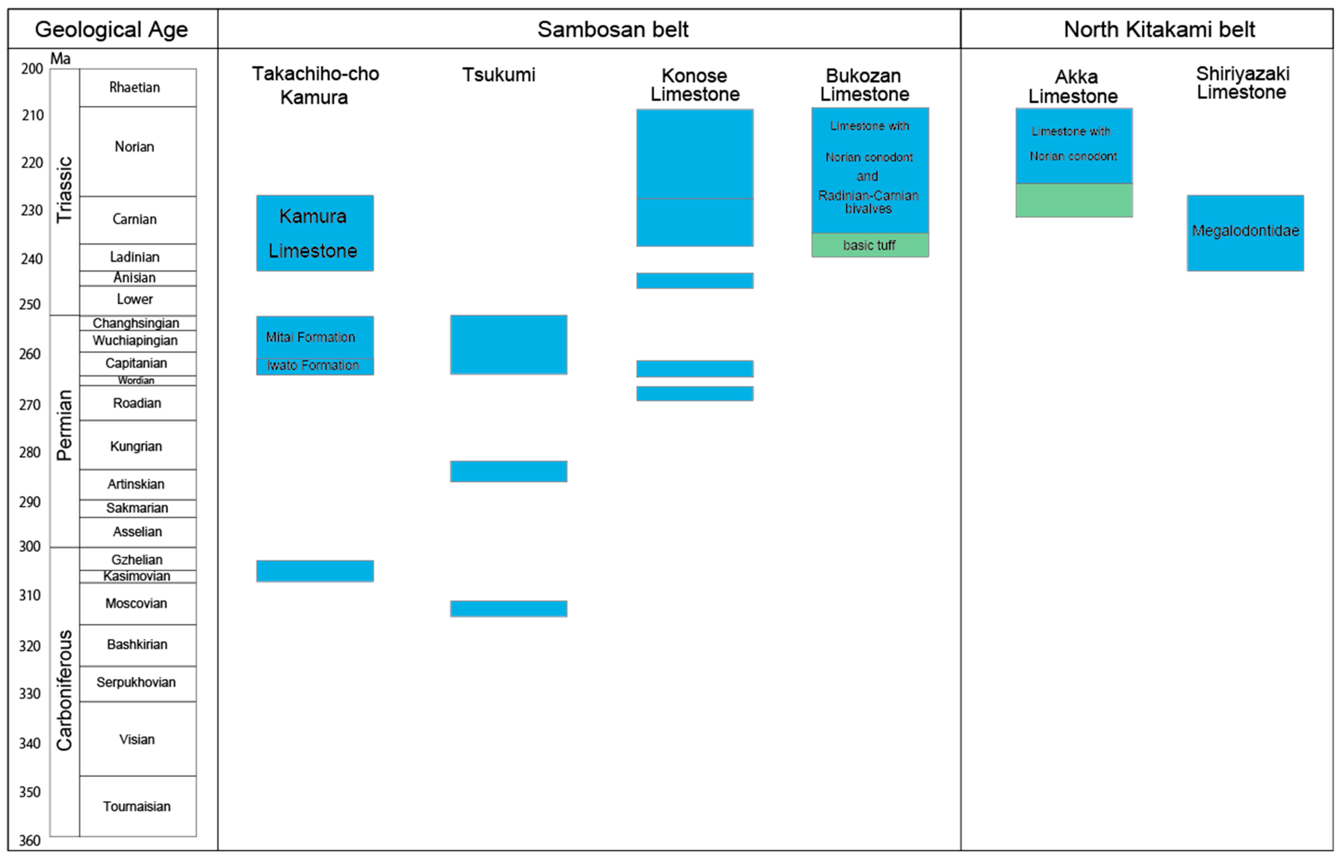
The earliest Cretaceous accretionary complex of the Sambosan belt consists of weakly deformed mélange units, and many of the incorporated blocks are regarded as sedimentary mélanges formed by submarine landslides—i.e., olistostromes [41]. Therefore, older limestone blocks, such as those of Carboniferous age, may have origins distinct from those of the Triassic limestones. Typical limestone blocks in the Sambosan belt are Kamura Limestone, Tsukumi Limestone, Konose Limestone, and Bukozan Limestone (Figure 6).
This earliest Cretaceous accretionary complex is not limited to the Sambosan belt but is also widely known in the Northern Kitakami belt. In the Northern Kitakami belt, rocks exhibit strong cleavage and have experienced thermal metamorphism associated with Cretaceous granite intrusions, making fossil recovery rare and rendering the distinction between Jurassic and earliest Cretaceous accretionary complexes ambiguous. Akka Limestone is the largest limestone body in the Northern Kitakami belt [70]. Shiriyazaki Limestone, also located in the Northern Kitakami belt, is a very small-sized limestone block which includes Triassic megalodontoid bivalves such as Dicerocardium sp. [71].
In the Takachiho area of Miyazaki Prefecture, the stratigraphy includes the Kamura Limestone (Kamura Formation) and the Mitai Formation (Upper Permian), as well as the Iwato Formation (Middle Permian) [72]. The Tsukumi Limestone in Ōita Prefecture hosts the largest limestone quarry in Japan, where fusulinid fossils from the Carboniferous to Permian have been discovered [73]. In the Konose area of Kumamoto Prefecture, the relationship between the Triassic and Permian limestones within the Konose Limestone remains unclear [74]. In contrast, the Bukozan Limestone and the Akka Limestone are formed atop Early Triassic basalt and are considered to represent independent atoll reefs, distinct from Permian limestone. Bukozan Limestone, located in the Kanto Mountains, is a 450-m-thick, massive limestone lacking bedding. Fossils are rare, but Triassic conodonts have been reported [75,76,77].

3.4. Autochthonous Arc-Shelf (AAS) Limestone

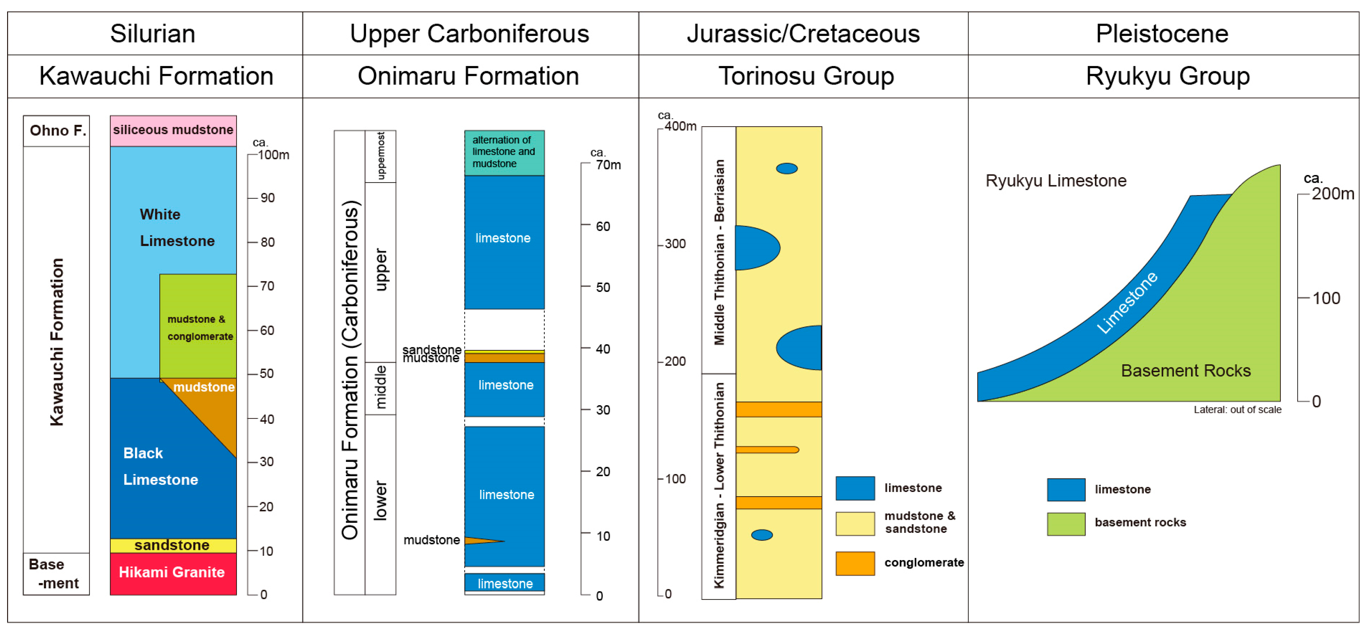
Japan’s AAS Limestones range in age from the Paleozoic to the Cenozoic. This section describes the lithofacies and stratigraphy of representative AAS Limestones from each era—Paleozoic, Mesozoic, and Cenozoic—highlighting their distinct characteristics. Figure 7 presents the lithofacies and stratigraphic frameworks of representative limestones for which detailed stratigraphic information is available [78,79,80,81,82].

3.4.1. Paleozoic AAS Limestones

AAS Limestones in Japan occur throughout all eras of the Phanerozoic Eon: the Paleozoic, Mesozoic, and Cenozoic. In the Southern Kitakami belt and the Kurosegawa belt, Paleozoic limestone formations are well known. In the Southern Kitakami belt, limestones are prominently developed in the Silurian Kawauchi Formation and the Oku-Hinotsuchi Formation and are also present in the Upper Carboniferous Onimaru and Nagaiwa formations, as well as in the upper Middle Permian Iwaizaki Limestone and Kanokura Formation (Figure 7) [82]. However, the strata of the Southern Kitakami belt mainly consist of terrigenous clastic rocks such as mudstone, sandstone, and tuff, with limestone intercalated among them. These Paleozoic sedimentary rocks of the Southern Kitakami belt originated from an immature island arc developed on oceanic crust along the margin of the Gondwana continent and filled shallow marine sedimentary basins around the arc. During warm oceanic conditions with the formation of very shallow seas and limited supply of terrigenous clastic material, the limestones in the Southern Kitakami belt were formed as AAS Limestones. The Devonian–Carboniferous Tobi-ga-mori Group in Iwate Prefecture hosts the Yūgendō Cave, while in Fukushima Prefecture, the Ordovician–Devonian Takine Group is known for caves such as Abukumadō and Irimizu.

3.4.2. Mesozoic AAS Limestones

In the Mesozoic shelf-type limestones, the Torinosu Group, which is structurally intercalated within the Southern Chichibu belt and the Kurosegawa belt, is well known [83,84]. The Torinosu Group was formed from the middle Jurassic to earliest Cretaceous [85,86,87], and it consists mainly of shallow-marine deposits such as mudstone and sandstone, accompanied by reefal limestone (Torinosu Limestone) [88]. Limestones of this age are distributed from Okinawa to Hokkaido, typically occurring as discontinuous lenticular bodies [80,89]. In Kochi Prefecture, Shikoku, limestone bodies up to 150 m thick and several kilometers in lateral extent are present, deposited conformably with siliceous sedimentary rocks and marlstone [89]. The Torinosu Limestone was initially interpreted as reefal limestone formed on a shallow-marine shelf [90]. However, because the Torinosu Limestone occurs as scattered spatial distribution and lacks rigid organic frameworks, it has been reinterpreted not as a typical coral-reef limestone but as carbonate mounds formed on a shelf environment with terrigenous clastic input [80,89]. In the Sagawa area, Kochi Prefecture, the type locality of the Torinosu Group, the Torinosu Limestone forms mounds above mudstone, and the limestone contains non-skeletal particles such as ooids, superficial ooids, pellets, and micritic envelopes, suggesting formation by calcium carbonate precipitation in tropical to subtropical seawater [80].
The Torinosu Limestone of Seiyo (Shikoku) is distributed at Kuranuki–Akehama, Shiroutani, Nomura, Oriai, Nakatsu-gawa and Kawazu-minami areas, from west to east. In these areas, strata referred to as the Imaidani Group have been correlated with the Torinosu Group. The Imaidani Group is divided into the lower Oriai Formation and the upper Nakatsugawa Formation [91], within which small limestone bodies of the Torinosu Limestone occur. These limestones are considered autochthonous because they are conformably associated above and below with calcareous sandstone and calcareous mudstone [92]. From the Nakatsugawa Formation, large fossils such as bivalves and ammonites have been reported [91]. Within the Torinosu Limestone of the Kuranuki–Akehama area, the Kuranuki-Shiraishi Cave is known; Nakatsu-gawa Tufa in the Nakatsu-gawa area and Anagami Cave in the Kawazu-minami area have developed in the limestone.

3.4.3. Cenozoic AAS Limestones

AAS Limestones formed during the Cenozoic, including the present, are widely distributed in the Okinawa region, which has maintained a warm environment throughout the era. On Minami-Daito Island, the Daito Formation, composed of limestone from the Miocene to Pliocene, hosts a well-developed limestone cave known as Hoshino-do. Other examples of Cenozoic AAS Limestones are found in the Ryukyu Limestone, which was formed during the Pleistocene (Figure 7). The Ryukyu Limestone is distributed throughout the Ryukyu Islands (Southwest Islands), located at the southernmost part of the Japanese archipelago, and constitutes the Neogene–Quaternary Ryukyu Group [93,94]. The Ryukyu Group consists of porous limestone formed from bioclastic material typical of reef complexes and terrigenous clastic layers [95].
Based on constituent organisms and composition, the Ryukyu Limestone is classified into coral limestone, algal ball limestone, Cycloclypeus–Operculina limestone, bioclastic limestone, and Halimeda limestone [81]. These limestones unconformably overlie the Shimajiri Group (Late Miocene–Pliocene), which is mainly composed of siltstone. The Ryukyu Limestone is subdivided into lower, middle, and upper members, each of which has different formation names depending on the island. For example, in the central and southern parts of Okinawa Island, the sequence consists of the Chinen/Ito-man Formation, the Naha/Kunigami Formation, and the Minatogawa Formation, in ascending order. In addition, the Ryukyu Group is overlain by Holocene uplifted coral reefs. Well-known caves developed in the Ryukyu Limestone include Shoryu-do Cave on Okinoerabu Island, Akasaki Cave on Yoronjima Island, Gyokusen-do Cave in the southern part of Okinawa Main Island, and Ishigaki Island Cave on Ishigaki Island.
The basement of the Ryukyu Islands consists of Jurassic accretionary complexes (Tana, Moromi, Maedake, and Izena formations), Early Cretaceous accretionary complexes (Tachinaga, Yonamine, and Shiroyama Formations), and Late Cretaceous accretionary complexes (Nago and Takigawa formations), which are unconformably overlain by the Eocene Kayo Formation and Late Miocene–Pliocene deposits [96]. Developed atop these geological units, the Ryukyu Limestone, AAS Limestone, frequently includes interbedded terrigenous clastic layers, indicating a depositional environment significantly different from that of the AOR Limestones.

3.5. Uplift and Exhumation of Limestone

AOR Limestones are incorporated into the accretionary complex when atolls are detached from seamounts in the deeper parts of the complex. Within the accretionary prism, newly accreted sediments are underplated beneath previously accreted sequences. Consequently, sedimentary units containing limestone are progressively displaced structurally upward, that is, toward the upper portions of the accretionary complex. Limestone bodies may especially reach the upper levels or even the surface of the prism along out-of-sequence thrusts (splay faults) that branch from the plate boundary fault (décollement).
In the Permian accretionary complex, limestone was accreted during the Middle Permian (ca. 260 Ma) and is unconformably overlain by shallow marine to terrestrial strata of the Middle to Late Triassic (240–210 Ma) [97]. This indicates that the limestone rose from the trench depths to nearshore environments in as little as 20 million years. In contrast, in the Jurassic and earliest Cretaceous accretionary complexes, limestones were accreted between the Early Jurassic and the earliest Cretaceous (190–140 Ma) and are overlain by pyroclastic flow deposits of the Late Cretaceous (90–70 Ma) [98]. The exposure occurred after approximately 70 million years; however, because it took place near the volcanic front, it is reasonable to assume that a longer time interval had elapsed than in the Permian accretionary complex.
The uplift of bedrock responsible for the development of karst topography has primarily been driven by crustal movements during the Quaternary. The Japanese Islands, situated in a compressional tectonic regime due to the subduction of the Pacific and Philippine Sea plates, have experienced rapid uplift of major mountain ranges since the Pliocene [99,100]. However, estimating the actual amount of uplift requires analysis of crustal deformation through correlating terraces and strata using volcanic ash layers, as well as evaluating fault activity. In the Shikoku region, the uplift during the past 100,000 years is estimated to be between 20 and 130 m, and more than 1000 m for the entire Quaternary [101]. Nevertheless, uplift rates vary significantly across different regions of Japan. In addition, to determine the true amount of uplift, it is necessary to consider erosion in mountainous areas and changes in sea level.
In the Chugoku Mountains, where many Permian accretionary limestones are distributed, the landscape had become a peneplain around 20 million years ago. The region subsided to near sea level around 16 million years ago, emerged around 14 million years ago, and became an uplifted peneplain in the late Middle Miocene [102]. The Ryukyu Limestone, as an example of AAS Limestones, provides valuable insights into uplift associated with crustal movements; however, any interpretation must also account for sea-level fluctuations. On the Kikai Island, the average uplift rate during the Holocene is estimated to be 1–2 m per 1000 years [95,103,104].

4. Results 2: Major Karst Landforms and Caves in Japan

4.1. Karst Landforms and Caves on the AOR Limestone 1: Akiyoshidai Karst Plateau

4.1.1. Akiyoshidai Karst Plateau Landforms

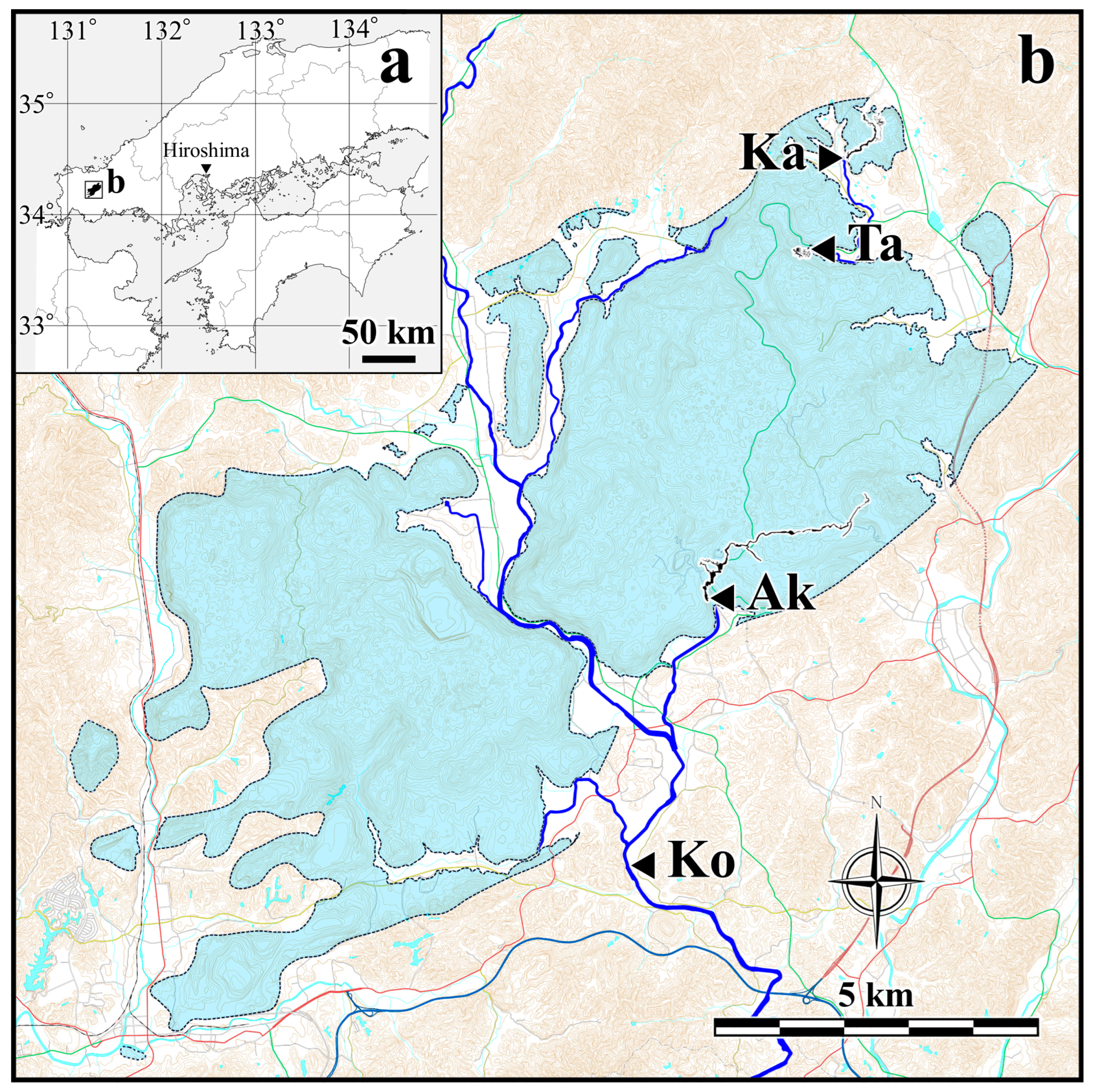
The Akiyoshidai Karst Plateau is a karst region located in the central-western part of Yamaguchi Prefecture, at the western end of Honshu Island, Japan, and covers an area of approximately 100 km2 (Figure 8). The elevation of the limestone distribution ranges from a maximum of 425.5 m to a minimum of 74 m, while the total thickness of the limestone, including the subsurface portion, is estimated to be around 1000 m [40]. The main part of the plateau consists of a relatively flat limestone surface at elevations between approximately 200 and 400 m. Around its margins, steep escarpments with relative heights exceeding 100 m are well developed.
The geomorphological characteristics of the Akiyoshidai Karst consist of the karst plateau and the surrounding karst plains. The karst plains are primarily formed by allogenic rivers and their extension into caves and constitute the largest fluvial karst system in Japan. On the surface of the plateau, deposits of allogenic river gravels are present, indicating that it represents an uplifted karst plain.
Due to fluvial erosion by the Koto River, which flows from north to south through the central part of the region, and the formation of fluvial karst plains in its surrounding areas, the Akiyoshidai Karst Plateau is divided into two major tablelands and several smaller, island-like plateaus. Although small in size on a global scale, the entire area is characterized by highly developed karstification, with a dense distribution of diverse karst landforms. These include an underground drainage system and caves, dolines and Karrenfeld on the plateau surface, and swallow holes and karst springs around the base of the plateau (Figure 9). This area represents a core value of the Miné-Akiyoshidai Karst Plateau Geopark, with a portion of its territory designated as a Special Natural Monument of Japan [40].
Although the detailed history between the accretion of the Akiyoshi Limestone to the continental plate in the Middle to Late Permian and its subsequent uplift to the surface remains unclear, it is inferred that the limestone body reached the near-surface by the Miocene (around 20 million years ago), when the entire Chugoku Mountains, including Akiyoshidai Karst Plateau, were peneplained. Karstification, which continues to this day, is thought to have begun at that time [102]. During this process, complex stress fields associated with plate movements led to the development of a three-dimensional fracture system within the limestone body [18]. Along these fractures, groundwater undersaturated with respect to calcium carbonate infiltrated from the surface, promoting dissolution and forming a three-dimensionally interconnected groundwater network [105]. Based on estimates of limestone dissolution rates, the onset of plateau formation through further uplift and erosion of surrounding areas is calculated to have occurred around 4.26 million years ago (Early Pliocene) [106].
Today, numerous karst depressions such as dolines have formed on the Akiyoshidai Karst Plateau, reflecting the underlying fracture system. The density of dolines reaches as high as 275 per km2 in the central part of eastern Akiyoshidai Karst Plateau [107]. Studies on limestone weathering and dissolution processes suggest that individual dolines on the Akiyoshidai Karst Plateau have developed over time spans on the order of several hundred thousand years [108,109,110]. Water entering the subsurface through these features reemerges as springs formed around the plateau margin after passing through the groundwater system. The overall configuration of the Akiyoshidai groundwater system has been revealed by fluorescent dye tracing tests [111,112], showing that groundwater generally flows westward in the eastern part of the plateau and eastward in the western part, with most of the discharge collected into the Koto River system that runs through the center (Figure 8).
As described in the previous chapter, the Akiyoshi Limestone originated from an oceanic island setting and is exceptionally pure due to the near absence of terrigenous clastic input [19]. It is a dense limestone with little to no bedding, which makes it less likely for planar caves to develop along bedding planes. Instead, a complex three-dimensional cave network has formed, governed by a dominant fracture system associated with compressive tectonics. To date, more than 453 caves exceeding 5 m in length have been identified in Akiyoshidai Karst Plateau [113], including seven caves over 1000 m in length and twelve with vertical relief exceeding 100 m. Exploration and cave geomorphological surveys suggest that many bathyphreatic caves exceeding 50 m in depth once functioned as conduits within the groundwater system [105,114]. The following sections provide detailed descriptions of three representative caves in Akiyoshidai Karst Plateau: Akiyoshido Cave, Taishodo Cave, and Kagekiyo-ana Cave.

4.1.2. Akiyoshido Cave

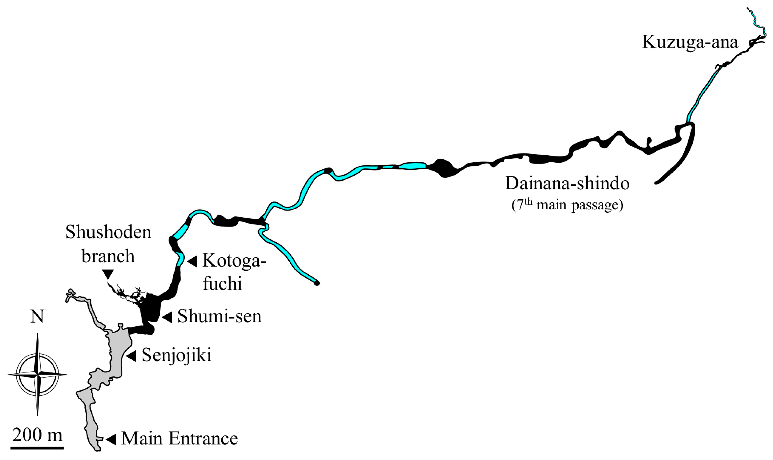
Akiyoshido Cave is the longest and largest cave within the Akiyoshidai Karst Plateau (Figure 10), with a total surveyed length of approximately 11.2 km [115] and a vertical range of about 135 m. A major underground river flows through the main passage, draining a wide area in the southern part of eastern Akiyoshidai [111,116]. About 1 km of the downstream section is open to the public as a show cave. The main entrance of the cave is located at an elevation of approximately 82 m on the southern foot of eastern Akiyoshidai (34.22812° N, 131.303475° E; Figure 11), and both an artificial tunnel and elevator entrance have been constructed. Several natural entrances also exist.
The internal space of Akiyoshido Cave ranks among the largest in Japan. The total volume of the show cave is at least 384,000 m3 [117]. One of the most prominent chambers, known as Senjojiki, measures 185 m in length, 86.2 m in width, and 38 m in vertical extent [117], making it the largest natural cave chamber in the country. About 150 m northeast of the Senjojiki chamber is Shumi-sen (Mount Sumeru), the second-largest chamber in Japan, with a width of 70–110 m and a height difference of approximately 50 m.
Upstream of Senjojiki is a non-public section of the cave. About 500 m upstream along the underground river (1 km from the main entrance), the cave passage submerges into an underground lake known as Kotoga-fuchi. Beyond this lake, the cave continues as a phreatic passage. Including seven intervening vadose segments [118], it connects to Kuzuga-ana, a natural entrance located about 2.7 km southeast of the main entrance [119].
In the section between the main entrance and Kotoga-fuchi, cave development has been strongly influenced by fracture systems trending N70°–80° W, N–S, N50° E, and N70°–80° E [120]. Large collapses have occurred at intersections of these fractures. In particular, the N70° W/50°–70° N faults are thought to have played a key role in forming the large chambers Senjojiki and Shumi-sen, and their orientations are consistent with those of other nearby caves [121].
The present Akiyoshido Cave follows the course of the underground river. Its floor is generally flat due to infill by clastic sediments, and typical solution landforms of the epiphreatic and vadose zones can be observed on the cave walls. In contrast, the cave ceiling preserves remnants of phreatic features such as solution pockets and tubes, indicating that the cave originally formed as a large phreatic (water-filled) cave.
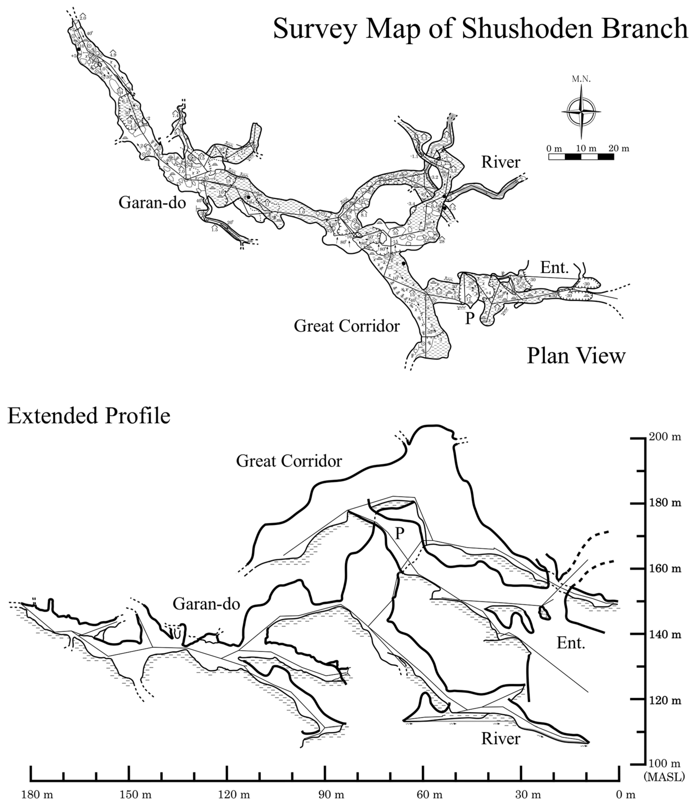
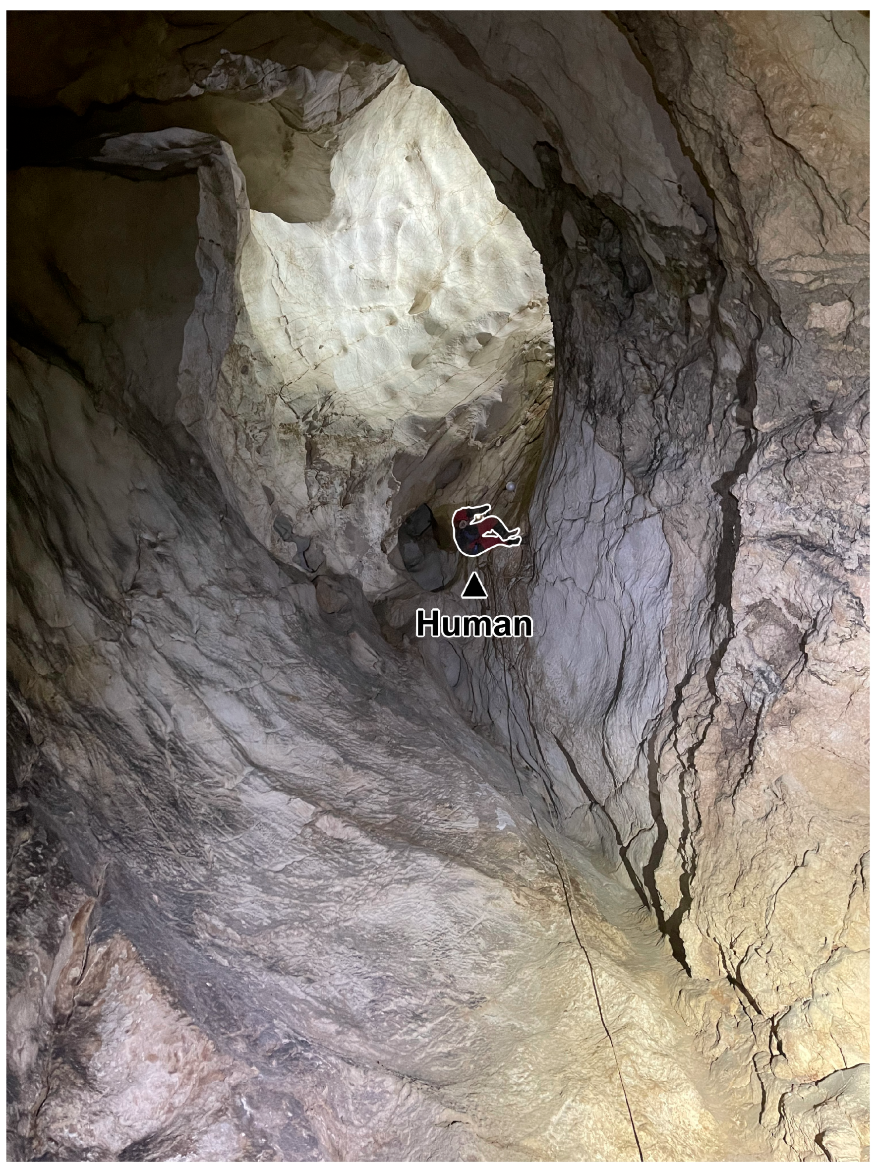
A notable branch of the cave, Shuhoden Branch, extends northwestward from the ceiling of Shumi-sen (Figure 11). Although the three-dimensional structure of the cave is controlled by the fracture system, the cave preserves its early morphology with minimal collapse (Figure 11). This branch consists of a series of phreatic dissolution tubes distributed between elevations of 203.4 m and 105.3 m, with major conduits having diameters of 5–15 m (Figure 12). Based on its structural and speleogenetic features, it is inferred that a Paleo-Akiyoshido Cave developed as a bathyphreatic cave with a vertical range of at least 90 m [114].
Regarding the development of Akiyoshido Cave, a hypothesis has been proposed based on the analysis of speleogens, speleothems, cave deposits distributed from the main entrance to Kotoga-Fuchi, and fluvial terrace features outside the cave [122], suggesting that the area below approximately 115 m in elevation began forming around 700,000 years ago [123]. If this hypothesis is applied to the Shushōden branch, where large phreatic tube passages extend above 200 m elevation, the initiation of cave formation in Akiyoshido may date back several million years. ESR dating of speleothems in the tourist section has yielded ages of approximately 250,000 and 700,000 years [124,125], indicating that most of the currently recognized passages had transitioned into the vadose zone several hundred thousand years ago. In addition, the discovery of minerals derived from the ASO-4 pyroclastic flow within sandy cave deposits [126], as well as the identification of ASO-4 pyroclastic flow deposits themselves [114], suggests that an underground river-type hydrological environment had already been established by at least 90,000 years ago.

4.1.3. Taishodo Cave

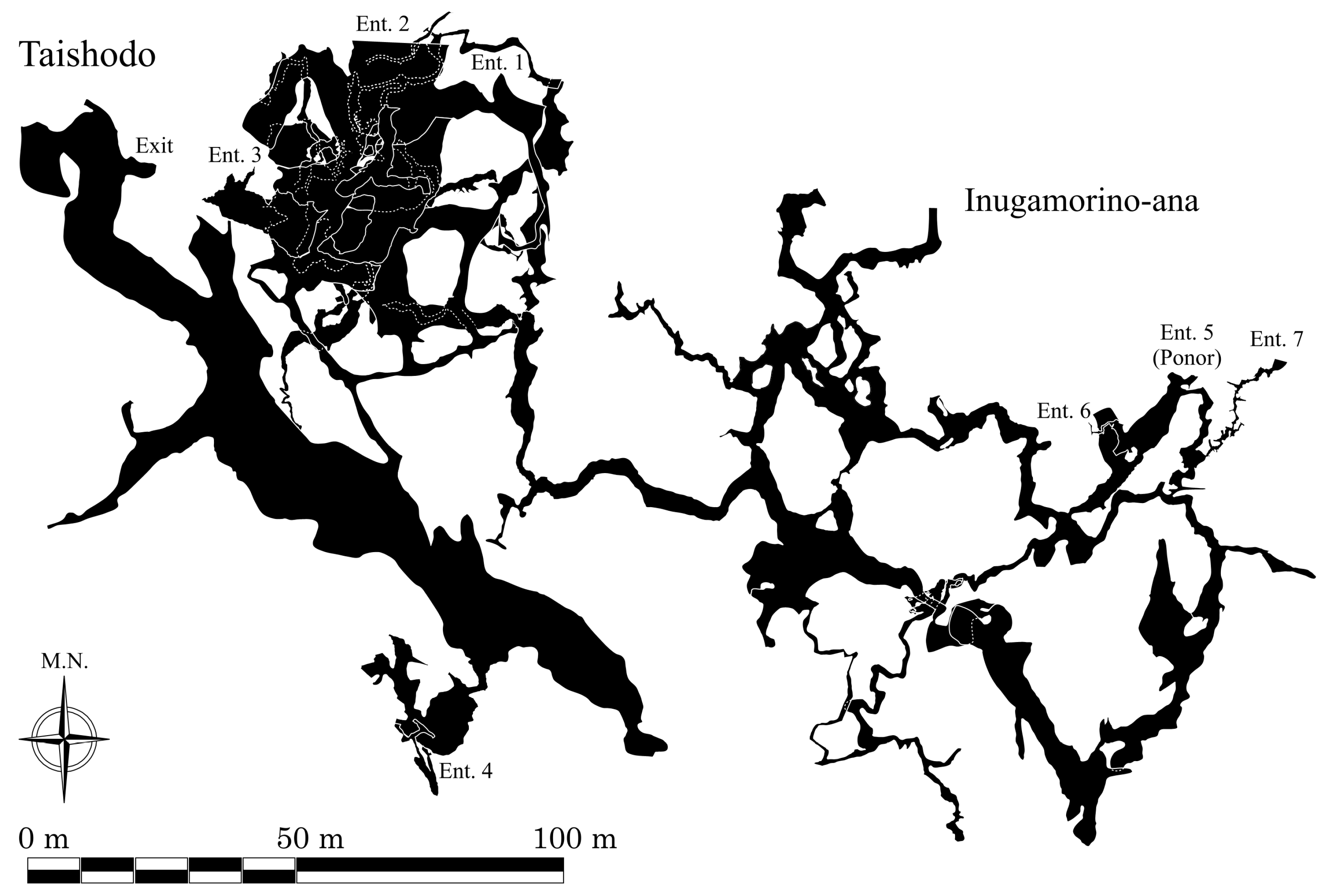
Taishodo Cave is located in the northeastern part of the Akiyoshidai Karst Plateau, in Aka-sayama, Mito Town, Mine City (34.27683° N, 131.32121° E; Figure 8), and part of the cave is open to the public as a show cave. In 2014, a connection with the neighboring Inugamorino-ana Cave, which is nearly the same size, was confirmed (Figure 13) [127]. As a result, the integrated system is also referred to as the Taishodo–Inugamorino-ana Cave (Figure 13). So far, a total surveyed length of 3363.6 m and a vertical range of 108 m (from 120 to 228 m in elevation) have been documented [128]. However, the lower part of the system—an extensive underwater cave below 120 m, corresponding to the regional lower groundwater level—has not yet been explored, and its full extent remains unknown.
Several caves are densely clustered near the Taishodo–Inugamorino-ana cave system, collectively known as the Taishodo Cave Group. Many of these caves contain exposed groundwater surfaces at similar levels, suggesting they are interconnected as part of a continuous groundwater cave system [129,130]. At the eastern edge of this group lies Inugamori Ponor, a vertical shaft about 40 m deep, which directly absorbs surface runoff—particularly water from Kagekiyo-ana Cave—during flood events. During such events, the local groundwater level can rise to approximately 160 m elevation. In recent years, increased frequency of heavy rainfall has enhanced surface erosion of sediments in the surrounding area, leading to the formation of new swallow holes [128]. Water entering the subsurface through these features flows through the northern groundwater system of eastern Akiyoshidai and resurfaces at Kanoide Spring, located about 1.6 km to the west [111].
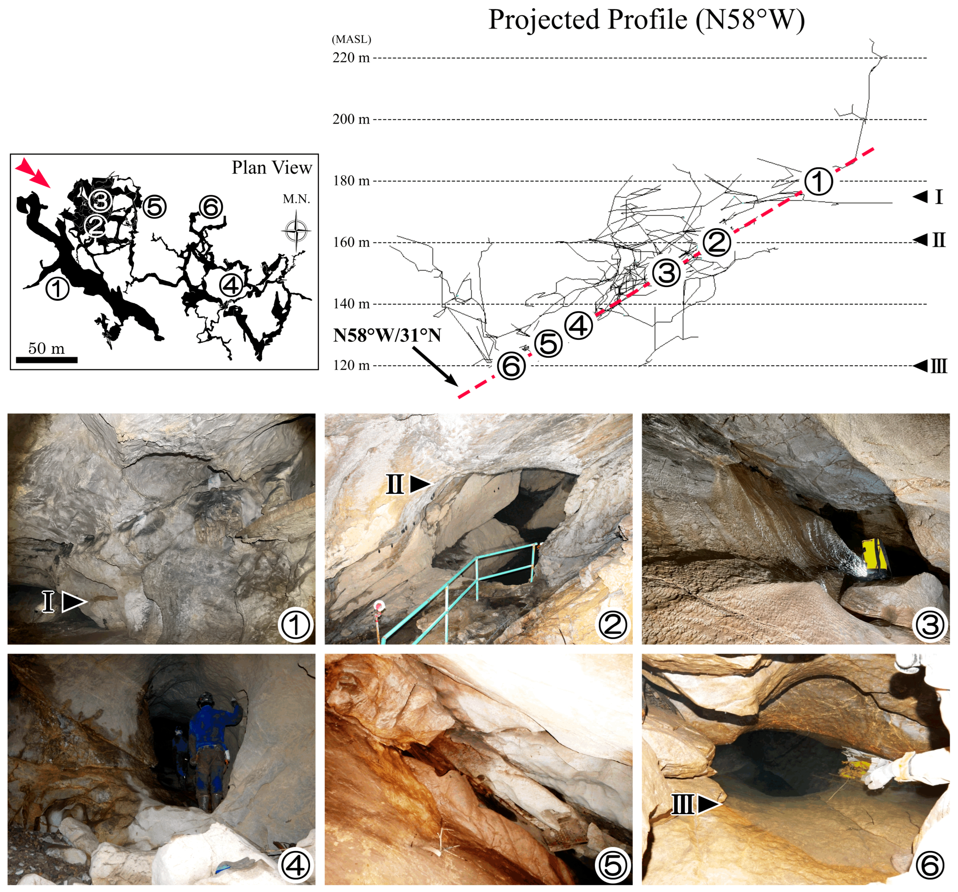
The Taishodo–Inugamorino-ana Cave is characterized by a complex structure combining maze-like tube passages and linear fracture passages [127]. Overall, collapse features and speleothems are limited, allowing clear observation of dissolutional morphologies that record speleogenesis. Near elevations of 170–180 m, horizontal caves formed by past underground rivers are preserved. Inclined phreatic passages extend both above and below this horizontal cave. In the upper zones, phreatic forms are well preserved, while below 170 m, widespread clay infill dominates, producing characteristic paragenetic features through upward dissolution in response to sedimentation [131]. Fragmentary evidence of lateral enlargement at around 160 m indicates activity associated with the present upper groundwater level.
Based on a three-dimensional analysis of cave survey data, the main framework of the cave consists of tubular passages controlled by a low- to medium-angle fracture system [105], which converge at approximately N58° W/31° N (Figure 14). Medium- to high-angle fractures striking NE-SW or N-S intersect this system, along which linear passages and phreatic rifts have developed. The interaction of these fracture-controlled features gives rise to the cave’s three-dimensional, maze-like structure.
Most of these spaces originated under phreatic conditions and extend continuously from over 220 m in elevation to below 120 m. This suggests that the original form of the Taishodo–Inugamorino-ana Cave was a bathyphreatic system with a vertical range exceeding 100 m. The current complex cave structure is interpreted to have developed through subsequent processes, including lateral and vertical incision caused by lowering of the groundwater table, and enlargement through paragenetic dissolution following the influx of non-carbonate sediments.

4.1.4. Kagekiyo-Ana Cave

Kagekiyo-ana Cave is a north-south cave that transects the small plateau known as Shishide-dai, located at the northeastern edge of the Akiyoshidai Karst Plateau. Its total length is estimated to be at least 4.6 km (Figure 15) [132], but many areas remain unsurveyed, and the actual extent is likely greater. Most of the main passage of the cave is developed as a show cave. The entrance (hereafter referred to as the Kagekiyo Entrance) opens at an elevation of 183 m on the southwestern foot of Shishide-dai (34.28958° N, 131.3266° E; Figure 8). Artificial lighting has been installed for approximately 560 m from the Kagekiyo Entrance, and deeper sections of the main passage beyond this point are also open to the public as an exploration course.
The cave contains an underground river that often becomes a losing stream during dry periods [133], but it discharges large volumes of water from the entrance during high-flow conditions, forming a temporary surface stream that flows toward Inugamori Ponor. At the northern base of Shishide-dai, two other cave entrances—Misumata-do and Anakuchino-ana—also receive inflow from surface streams. Until around 1980, it was possible to pass through the cave from the tourist area to Misumata Entrance [134], but sediment accumulation has since blocked this route.
There is a permanently submerged connecting passage between the main passage of Kagekiyo-ana and Anakuchino-ana. This passage was only successfully traversed during the record-setting droughts of 2021–2022, when the groundwater level dropped more than 20 m below the main passage [132]. Additionally, Shishino-nukeana Entrance opens at an elevation of approximately 280 m on top of Shishide-dai and connects to the main passage via a series of vertical shafts, reaching the main level about 88 m below. Taking this point as the highest and the connecting passage to Anakuchi-no-ana as the lowest, the total vertical range of Kagekiyo-ana Cave is approximately 110 m.
Shishide-dai, the plateau that hosts Kagekiyo-ana Cave, lies at the northern edge of the Akiyoshidai Karst and borders a non-limestone mountainous area to the north. Fluvial gravel and sand from rivers originating in this non-carbonate terrain have been deposited throughout the cave. At one point, the sediment reached nearly to the ceiling in parts of the main passage. However, prior to the opening of the show cave in 1964, a major sediment removal operation was carried out in 1962 [135], allowing for ceiling heights exceeding 2 m in most of the publicly accessible sections.
In the central part of the main passage, a horizontally flat ceiling extends for about 300 m, with notches and other features indicating development in the epiphreatic zone near the water table. Above this ceiling, anastomosing half-tubes and pendants can be widely observed [133,134], suggesting that the passage was buried in sediment for an extended period. In contrast, the final 100 m of the downstream section near the Kagekiyo Entrance features a relatively flat cave floor due to sediment fill, while retaining an overall elliptical cross-section with a diameter exceeding 10 m. (Figure 16). Many phreatic speleogens aligned along fractures are observed on the ceiling, suggesting that the passage originally developed as a large phreatic conduit.
The upstream features of this conduit are still unknown, but the intermittent losing and resurgence behavior of the underground stream and the fact that the connecting passage to Anakuchino-ana lies more than 20 m below the sediment surface suggest a high probability that an extensive buried cave system exists beneath the sediment-filled floor of the main passage.

4.1.5. Karst Development in Akiyoshidai

Karst development in Akiyoshidai is characterized by the lithology of the Akiyoshi Limestone, a typical AOR composed of massive, non-bedded, and exceptionally pure limestone, together with a complex fracture system formed under the stress field of a convergent margin. Dissolutional enlargement of this fracture system produced an extensive groundwater network, with many bathyphreatic caves that functioned as its conduits. Relatively gentle regional uplift and erosion of the surrounding strata led to the exposure of the limestone body as a plateau. On the plateau surface, doline karst reflecting the fracture system has developed, whereas along the margins, fluvial karst plains have formed through processes associated with allogenic rivers. Many caves have been infilled by non-carbonate sediments transported from upstream.

4.2. Karst Landforms and Caves on the AOR Limestone 2: Shikoku Karst and Rakan-Ana Cave

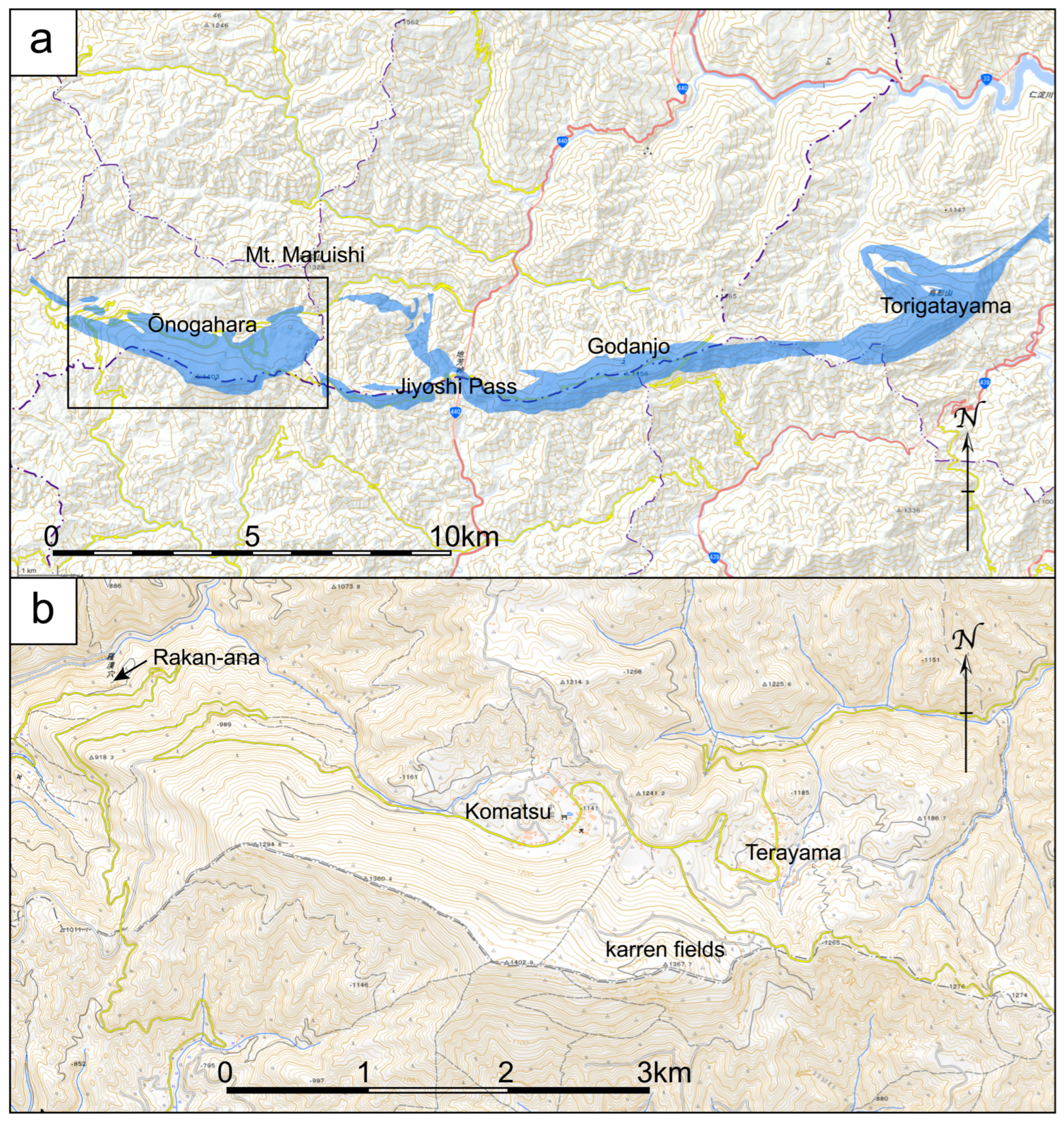
The Shikoku Karst forms karst landscapes atop mountainous ridges at elevations of approximately 1000–1480 m a.l.s., extending for about 30 km from east to west, from Ōnogahara in Seiyo (Shikoku) to Torigatayama in Kochi Prefecture (Figure 17). The northern slope of this region is characterized by well-developed karren. To the south lie a series of karst depressions in the Komatsu, Sasagatōge and Terayama areas (Figure 17) [136]. This area lies within a transitional zone from limestone to non-limestone formations, where the limestone appears as lenticular bodies, resulting in a landscape dominated by dolines [136].

Rakan-Ana Cave

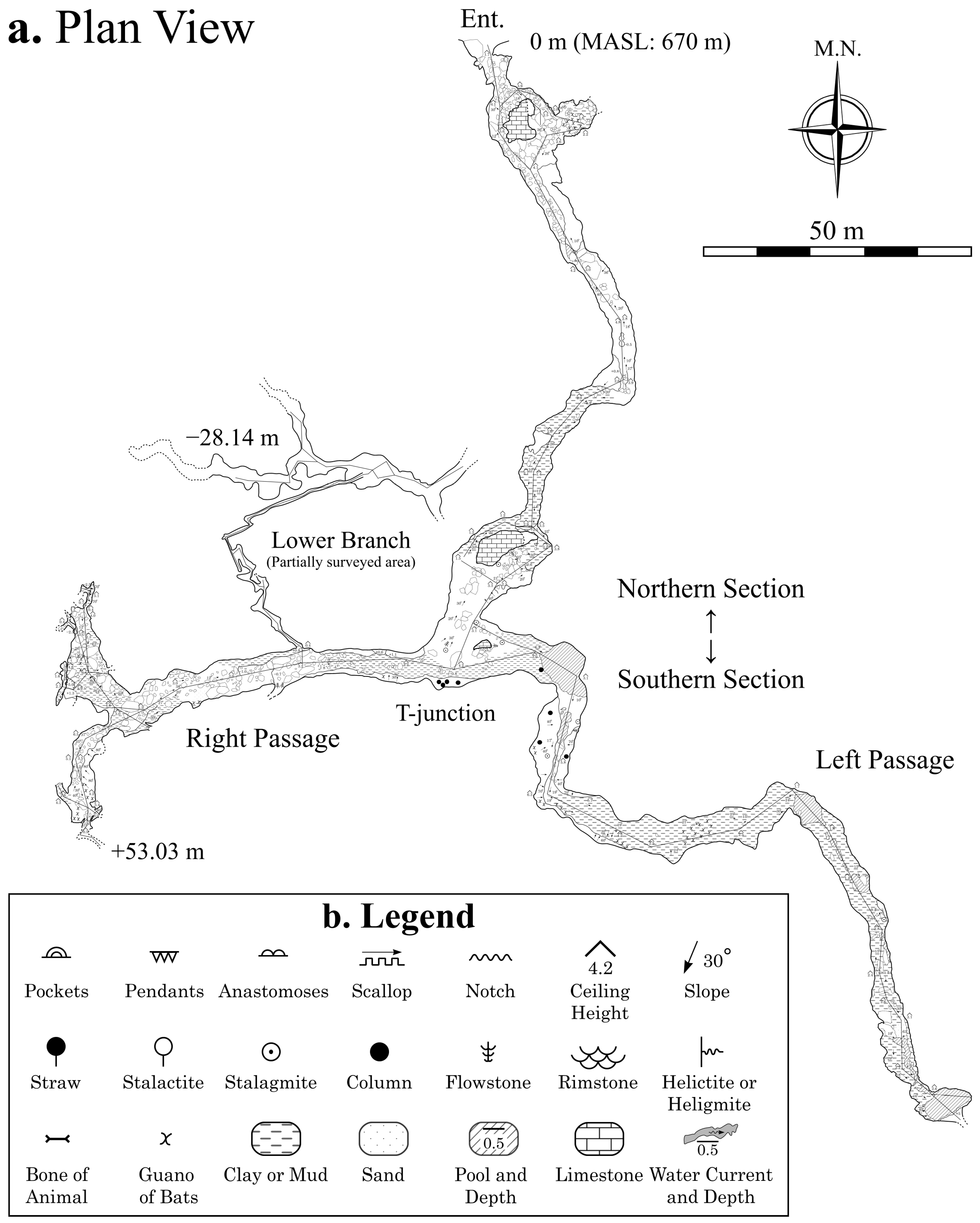
Rakan-ana is a limestone cave located on the northwestern foothills of the mountain range that constitutes the Shikoku Karst [137], in the Okubo district of Nomura Town, Seiyo (Shikoku) at an elevation of approximately 670 m a.s.l. (33.48887° N, 132.83739° E; Figure 17). It is the longest cave in the Shikoku Karst region, with a surveyed length of 768.5 m and a total vertical range exceeding 81.2 m.
The cave is designated as a Natural Monument of Ehime Prefecture [138] and a geosite of the Shikoku Seiyo Geopark. It is publicly accessible under the administration of local authorities. An entrance gate has been installed in recent years, and portions of the interior are equipped with concrete walkways, stairs, and informational signs.
Figure 17. Distribution of limestone and karst landscapes in the Shikoku Karst. (a) Distribution of limestone in the Ōnogahara—Torigatayama area (after Seamless Geological Map [139]), (b) Major karst landscapes in the Shikoku Karst (after GSI Maps [140]).
Geosciences 15 00393 g017
The overall morphology of Rakan-ana Cave displays a T-shaped plan view, oriented with the south at the top (Figure 18). It is broadly divided into a northern section extending from the entrance at the northern tip to the T-junction, and a southern section that further branches into a right passage (west side) and a left passage (east side), with an additional lower-level branch diverging midway along the right passage. The cave is primarily composed of low-gradient passages, with almost no flat areas.
The northern section follows a northwest-trending, west-dipping low-angle fault, whereas the southern section is dominated by north–south-trending faults dipping north to east at low to moderate angles. Many fractures obliquely intersect both fault systems, creating a complex network. Throughout the cave, well-developed corrosion features of phreatic zone origin are evident, and it is inferred that the original structure of Rakan-ana Cave was formed by dissolution along this fracture system below the water table [141]. The limestone in the northern section is dense and preserves well-defined tube passages of phreatic origin, while the southern section shows more fracturing, making dissolution features less evident. Around the T-junction connecting the two sections, multiple faults converge, forming a relatively large hall-like chamber with signs of collapse. The cave floor is largely covered by rounded to sub-rounded non-limestone gravels and clay sediments. The presence of half-tube features on the ceiling suggests that the cave was widely buried by clastic sediments. No flowing water is typically observed in the cave, but during heavy rainfall, a significant volume of groundwater enters through the fracture system, flooding most of the cave except for the relatively elevated right passage.

4.3. Representative Karst Landforms and Caves on the AAS Limestone 1: Torinosu Limestones

The Torinosu Limestone, a shelf-type limestone of Jurassic age, is distributed in a narrow, elongated manner within the Chichibu belt, which extends from the Kanto region through the Kinki, Shikoku, and Kyushu regions of Japan. Within this belt, the limestone typically occurs as small-scale, fault-bounded bodies. In the southern part of Seiyo (Shikoku), the limestone appears as lens-shaped masses near the boundary between the Southern Chichibu belt and the Kurosegawa belt. Although each individual limestone body is relatively small, distinctive karst landforms are well developed at several sites. Some of these have been designated as geosites within the Shikoku Seiyo Geopark. In the following sections, we introduce representative examples: Anagami Cave, Nakatsu-gawa Tufa, and Kuranuki-Shiraisi Cave of Seiyo (Shikoku) (Figure 19).

4.3.1. Anagami Cave

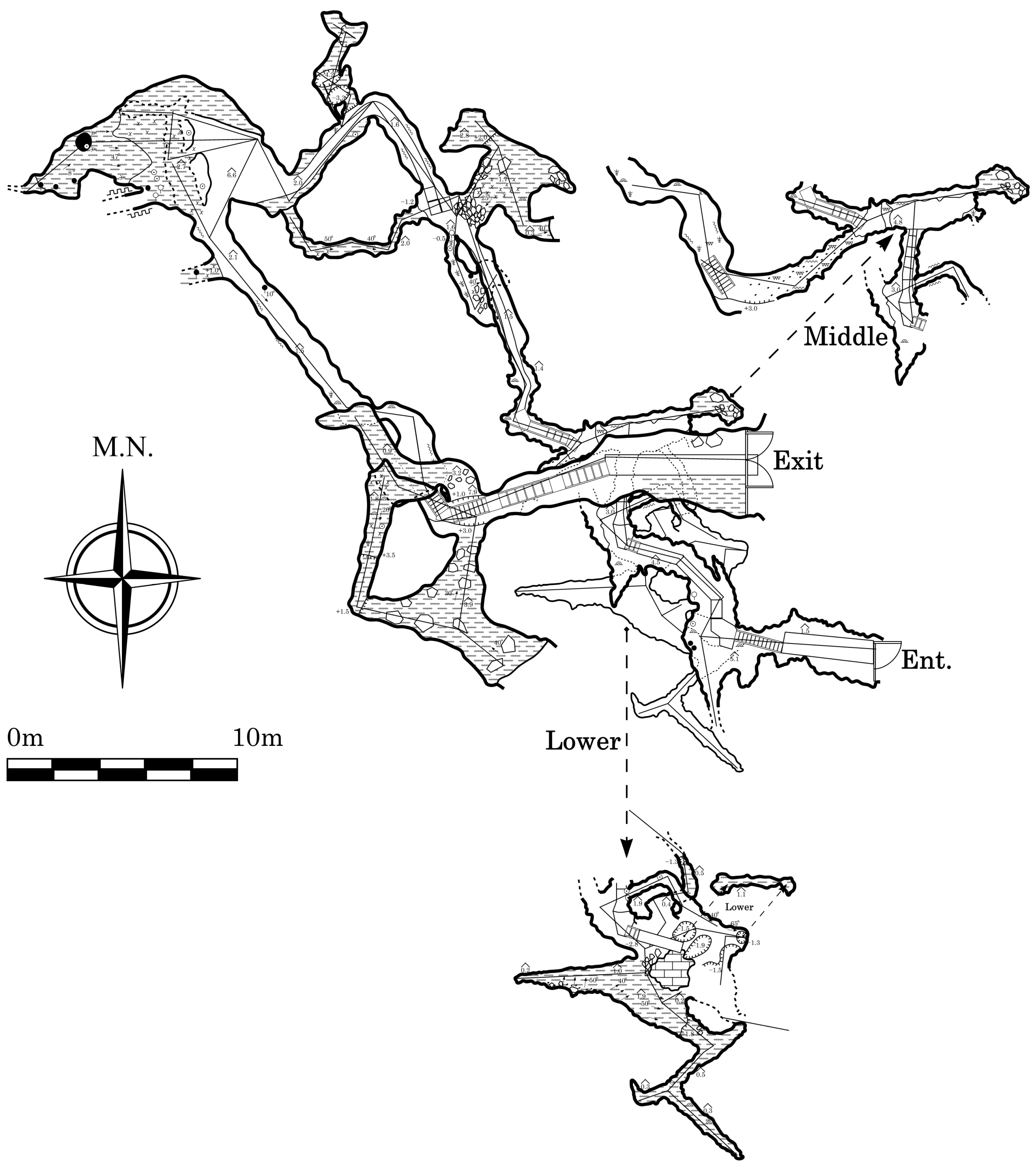
Anagami Cave is a limestone cave located at an elevation of 281.4 m a.s.l. (33.38438° N, 132.81894° E) on the western bank of the Kurosegawa River in the Kawazu-minami area of Shirokawa Town, Seiyo (Shikoku) (Figure 19). The cave has a surveyed length of 282.9 m and a total vertical range of 22.6 m (Figure 20), with approximately 100 m of the passage currently open to the public as a show cave [143]. The cave has two entrances: an upper entrance used as the exit for tourists and a lower entrance used as the entry point. While the upper entrance is a natural opening, the lower one was excavated during the development of the show cave to facilitate access. The surrounding geology belongs to the Torinosu Group, and the cave has developed within a limestone body with a lateral extension of several hundred meters.
The cave passages are moderately irregular in elevation, with flat areas limited to sediment accumulation zones or artificially leveled sections. Overall, solutional features dominate the interior, although localized development of speleothems is also observed. The basic structure of Anagami Cave is governed by a fracture system composed mainly of moderately to steeply dipping north-northwest–trending fractures dipping east, and steep east–west-trending fractures dipping south. These intersect to form a grid-like pattern, and the resulting maze-like passages are thought to have expanded through dissolution under phreatic conditions. Many of the passages, regardless of elevation, are filled with clay sediments containing rounded to sub-rounded non-limestone gravels. In such areas, paragenetic upward dissolution enlargement due to sediment burial processes can be observed. Additionally, in certain parts of the cave, passages formed by lateral and downward erosion under vadose conditions can be observed. Based on these observations, the current structure of Anagami Cave is interpreted to have formed from a three-dimensional phreatic cave system that was extensively infilled with sand, gravel, and filtrated clays [144], and later partially evacuated by underground river activity following a drop in the water table [143]. Currently, the cave does not reach a water table. However, a swallow hole is located along a stream valley of the north-northwest extension of the fracture system, and a spring on the Kurosegawa River to the south-southeast discharges a large volume of groundwater. These observations suggest the possible presence of a groundwater system beneath the cave that connects both features.

4.3.2. Nakatsu-Gawa Tufa

Approximately 3.4 km west of Anagami Cave, along a small stream flowing through a valley in the Furuichi area of Shirokawa Town, Seiyo (Shikoku) (33.38120° N, 132.78279° E; Figure 19), a large-scale terrestrial carbonate deposit known as the Nakatsu-gawa Tufa has developed (see location map). Tufa is a porous calcium carbonate deposit typically found in springs or streams in karst regions. It forms through biologically induced mineralization, whereby photosynthetic organisms consume dissolved CO2 in calcium carbonate-supersaturated water, leading to the precipitation of calcite [145].
The Nakatsu-gawa Tufa extends continuously for 380 m along the river course (Figure 21), reaching a maximum width of approximately 10 m in the upstream section. The river’s source is a spring that discharges groundwater from the Torinosu Limestone body located in the southeastern mountains. It is estimated that approximately 5.8 tons of calcium carbonate precipitate annually along the stream’s course [146].
This tufa deposit exhibits well-defined annual laminations, consisting of dense, lighter-colored laminae formed during summer and porous, darker-colored laminae deposited in winter. The surface of the deposit is densely covered by filamentous cyanobacteria, whose photosynthetic activity is believed to play a critical role in promoting calcite precipitation [147]. Chemical analyses further reveal that approximately 10% of the precipitated calcium carbonate is biologically induced through photosynthesis, quantitatively demonstrating the contribution of biological activity to the deposition process [148].
Still actively growing today, the Nakatsu-gawa Tufa is one of the largest known terrestrial carbonate deposits in Japan. Its ongoing formation and the involvement of biological activity make it an exceptionally valuable subject for studying biogeochemical processes in carbonate sedimentation. These deposits form terraces, small basins, and rimstone dams, with mosses and aquatic plants playing a significant role in accelerating carbonate precipitation. The layered structure and embedded plant remain reflect both physical and biological processes involved in the formation. In addition to its geomorphological and sedimentological importance, the Nakatsu-gawa Tufa offers valuable information on the paleoenvironment and is used in studies related to recent environmental changes and the development of karst hydrological systems.

4.3.3. Kuranuki-Shiraishi Cave

Kuranuki-Shiraisi Cave is located in the mountainous area south of the Kuranuki district, Mikame Town, Seiyo (Shikoku), opening at an elevation of 159 m a.s.l. (33.34113° N, 132.43126° E) (Figure 21). The cave is developed within the Torinosu Limestone, and dense layers of thick-shelled bivalves have been discovered in the limestone near the cave [149]. The limestone body extends approximately 500 m north–south and 300 m east–west, distributed within an elevation range of 100–300 m. Surrounding the limestone are clastic rocks composed of alternating beds of mudstone, sandstone, and conglomerate, which are in fault contact with the limestone.
Two valleys run along the east and west sides of the limestone body, converging at its northern end to form the Shiraishi River. The eastern valley, formed near the boundary with non-limestone rocks, maintains perennial flow, whereas the western valley commonly becomes a dry channel, as it flows into the limestone body. Numerous swallow holes and karst springs are distributed throughout the area, with repeated occurrences of river water sinking underground and resurging. Authors tried the fluorescent dye tracing tests [150], and they indicated the presence of a complex karst groundwater system.
Kuranuki-Shiraisi Cave is a small cave with a total surveyed passage length of 24.2 m and a vertical difference of 7 m (Figure 22). Although situated at a moderate elevation within the limestone distribution area, the cave has a groundwater table at 156.4 m, below which extends a submerged cave formed by a phreatic tube approximately 1 m in diameter, whose full extent remains unknown.
The limestone surrounding the cave is fault-bounded to the north by mudstone along a fault striking N70° E and dipping 60° N, which likely acts as an impermeable barrier, impeding groundwater movement and maintaining a high water level. Along this fault, springs discharging water with a high concentration of calcium carbonate flow continuously (unpublished data). The spring water typically forms tufa deposits along its course toward the valley on the western side, after which it is, in many cases, swallowed into the subsurface. The overall morphology of the cave is fundamentally characteristic of a phreatic genesis, originating as a submerged cave. However, widespread evidence of paragenetic enlargement is also present, suggesting that the cave experienced a period of infilling by non-limestone sand and gravel supplied either from outside the cave or from upstream portions of the submerged system.
About 30 m south of the cave, a wind hole exhibits chimney-effect airflows [151], suggesting an undiscovered upper entrance. However, smoke tracing tests [114] conducted in midwinter detected no emission points within a 200 m radius above the wind hole, implying that an extensive subterranean void may exist beyond this area.
Although Kuranuki-Shiraisi Cave is very small, preliminary investigations of its geomorphology, hydrology, and microclimate suggest the presence of a complex groundwater system and large subterranean voids in the surrounding area, thus representing an important research site for understanding karst development within the Torinosu Formation.

4.3.4. Karst Development in the Torinosu Limestone, Seiyo (Shikoku)

The Torinosu Limestone in Seiyo (Shikoku) occurs as small lens-shaped bodies within marine strata dominated by sandstone and mudstone. Rapid uplift at a convergent margin formed mountainous terrain in the area, during which a fracture system developed within the limestone bodies. As a result, three-dimensional maze-like caves, controlled by the fracture system and, in some cases, by geological boundaries, have developed, whereas cave development along bedding planes typical of AAS is absent. Extensive groundwater networks are not established in these scattered limestone bodies, and small groundwater systems have developed within individual bodies, connecting swallow holes and karst springs at the upstream and downstream geological boundaries, respectively. Consequently, many karst springs occur in the mountains, and large tufas are often formed along their flow paths descending the mountain slopes.

4.4. Representative Karst Landforms and Caves on the AAS Limestone 2: Pleistocene Ryukyu Limestone on the Okinoerabu Island

The Ryukyu Group (Ryukyu Limestone), widely distributed in the Nansei Islands of southern Japan, represents coral reef complex deposits formed during the Pleistocene of the Quaternary (2.58 Ma–10 ka). The Ryukyu Group developed throughout the Amami and Okinawa regions, with its northern limit on land at Kodakarajima in the Tokara Islands. The basement of the Ryukyu Group consists of pre-Tertiary rocks on Amami Oshima, Tokunoshima, Okinoerabu, Okinawa Northern Region, Ishigaki, and Iriomote islands, whereas in other areas it is composed of the Shimajiri Group, a sequence of marine deposits formed from the Pliocene to early Pleistocene. On top of these basement rocks, the Ryukyu Group—characterized by coral limestone—was widely deposited after 1.65 Ma in the Pleistocene.
Among karst regions in Japan, the Ryukyu Limestone area represents the largest in extent, compared with those built by older limestones. Uplifted ancient coral reefs, forming plateaus of Ryukyu Limestone, together with modern coral reefs fringing the islands, constitute the distinctive landscapes of the Amami–Okinawa region. The Ryukyu Limestones have been strongly eroded on land, and the characteristic features of coral reef topography are rarely preserved. These Ryukyu Limestones are subject to dissolution and exhibit well-developed karst features such as caves and dolines [152,153,154,155,156,157].
These coral reef terraces are restricted to areas south of Tanegashima Island (30° N). On Yonaguni and Okinoerabu islands, they developed as uplifted fringing reefs or barrier reefs surrounding mountains composed of older rocks. In contrast, Miyako and Kikai islands are characterized by flat-topped uplifted atolls (table reefs) with relatively recent uplift ages [158]. On Minami and Kita Daito islands, which are covered by AOR Limestone, the islands assumed basin-like topography reflecting the former atoll structure [154], but sedimentological studies have shown that the present landforms are not true atolls but subaerially eroded karst features [159].
Okinoerabu Island, located in the central Ryukyu Arc, is a classic example of an island karst developed on a limestone plateau with multiple terraces, classified as subtropical maritime karst in terms of climato-geomorphology (Figure 23). Karst landforms include coastal karst features, dolines and dry valleys, as well as well-developed underground rivers and caves. In particular, the density of dolines and caves is among the highest in Japan, making it one of the representative karst areas of both the Ryukyu Limestone region and Japan as a whole.
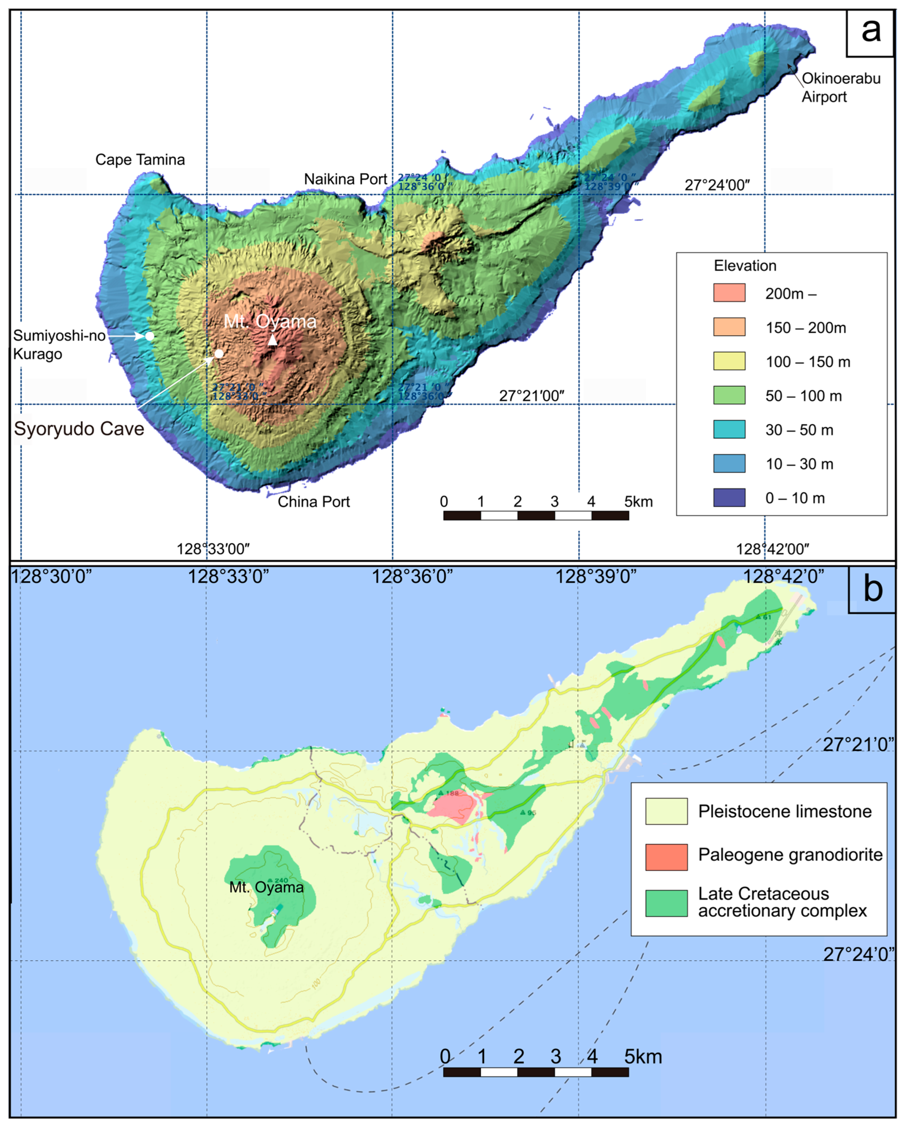
Okinoerabu Island is an elongated triangular island approximately 20 km long in a WSW–ENE direction, with its highest point at Mt. Oyama (246 m a.s.l.) in the southwestern part of the island. Coral reef terraces (raised coral reefs) are distributed concentrically on the Neori Formation of the Late Cretaceous Shimanto accretionary complex. The Ryukyu Limestone on Okinoerabu Island is a Quaternary Pleistocene coral-reef–karst complex, consisting of lower and upper units [156]. While most Pleistocene limestones on the stable continental shelf, such as those in the Bahamas [162], were submerged during Holocene sea-level rise, the Ryukyu Islands, located on the continental side of a subduction zone, were uplifted, so the limestone remained emergent. Distributed below 200 m elevation, the limestone is extensively karstified due to a subtropical monsoon climate with approximately 2000 mm annual rainfall and active biological processes.
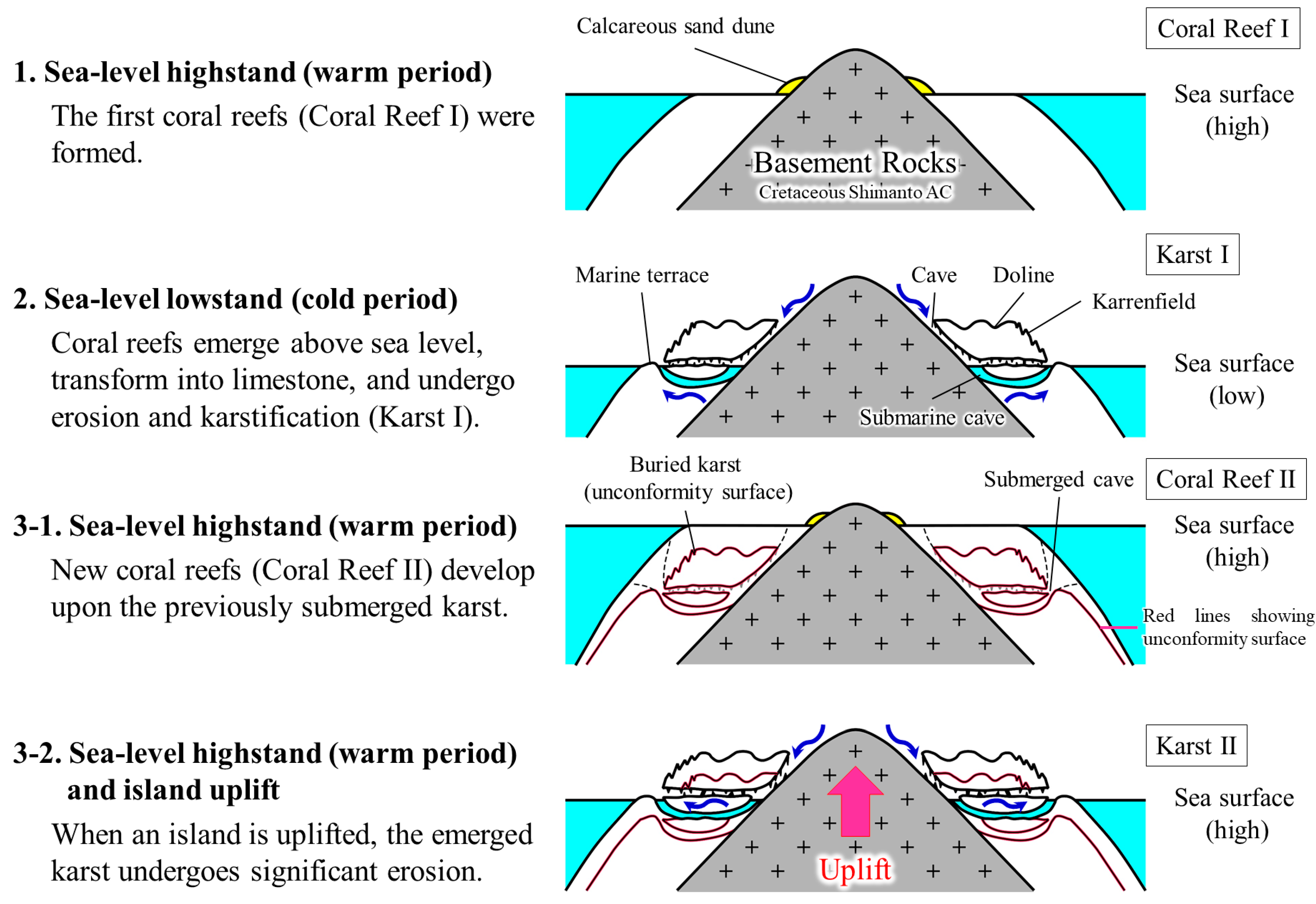
The most distinctive feature of the Ryukyu Limestone karst on Okinoerabu Island is its relatively young age and the close spatial and temporal relationship between the karst system and the coral reef system, forming an integrated complex (Figure 24). During sea-level high-stands, the island was submerged and coral reef limestone was deposited; during low-stands, the island emerged, and the limestone was subjected to erosion and karstification. During subsequent highstands, new coral reefs developed on pre-existing karst topography [163]. At China Port, coral reefs began to grow upward about 7000 years ago over an older karst surface located at a depth of 11 m [164]. On the limestone plateau surrounding Mt. Oyama, underground river caves meander under the influence of ancient coral reef topography and lithology within the limestone. Because the present is a sea-level high-stand, the downstream sections of underground river caves formed during low-stands are expected to continue beneath the sea surface as submarine caves. In this region, younger coral reefs and terrestrial karst are so closely associated.
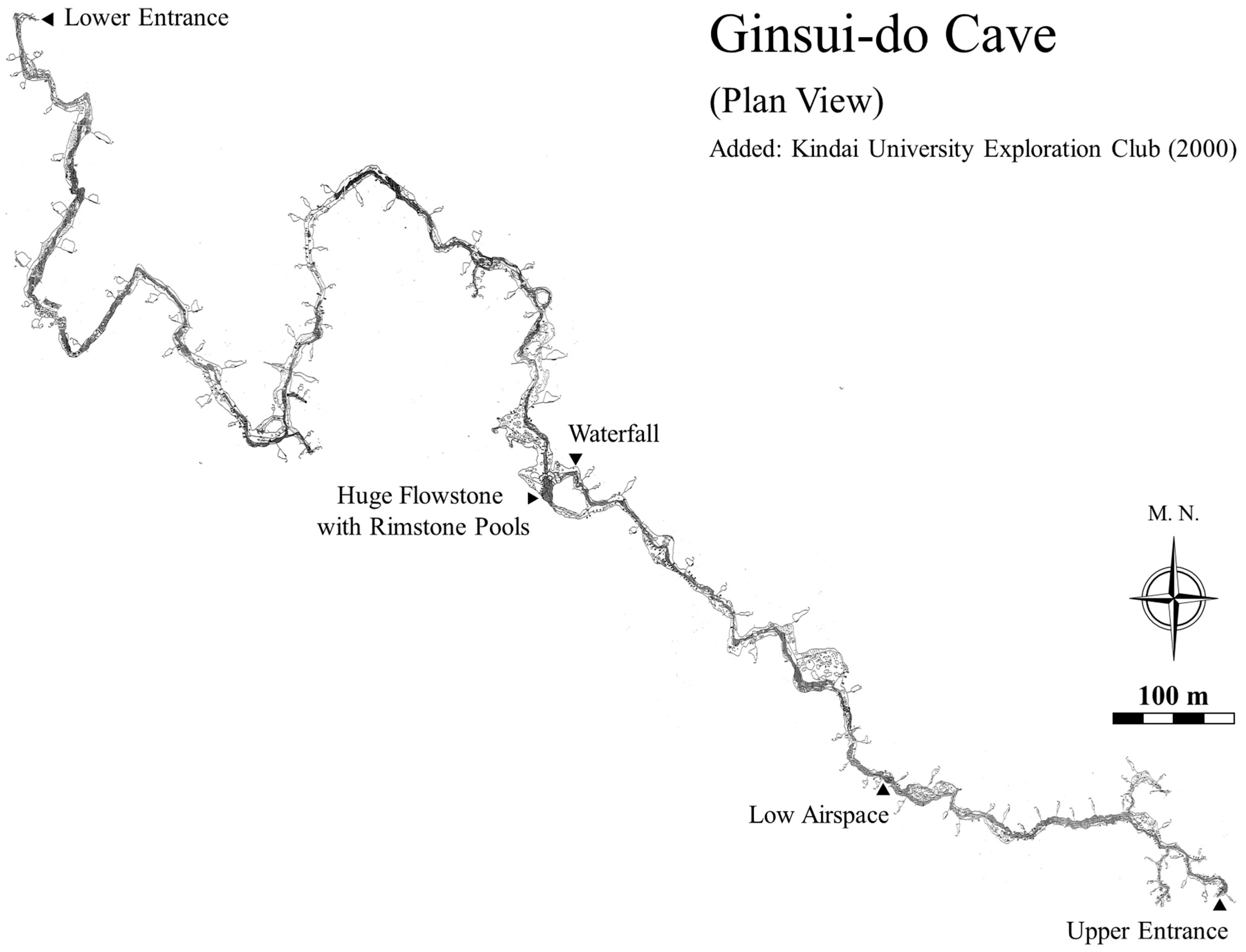
The island contains approximately 200–300 caves and solutional cavities, most of which are distributed radially from Mt. Oyama toward the sea. The authors describe three caves: Shoryu-do Cave, Hakuho-do Cave, and Ginsui-do Cave.

4.4.1. Shoryu-Do Cave

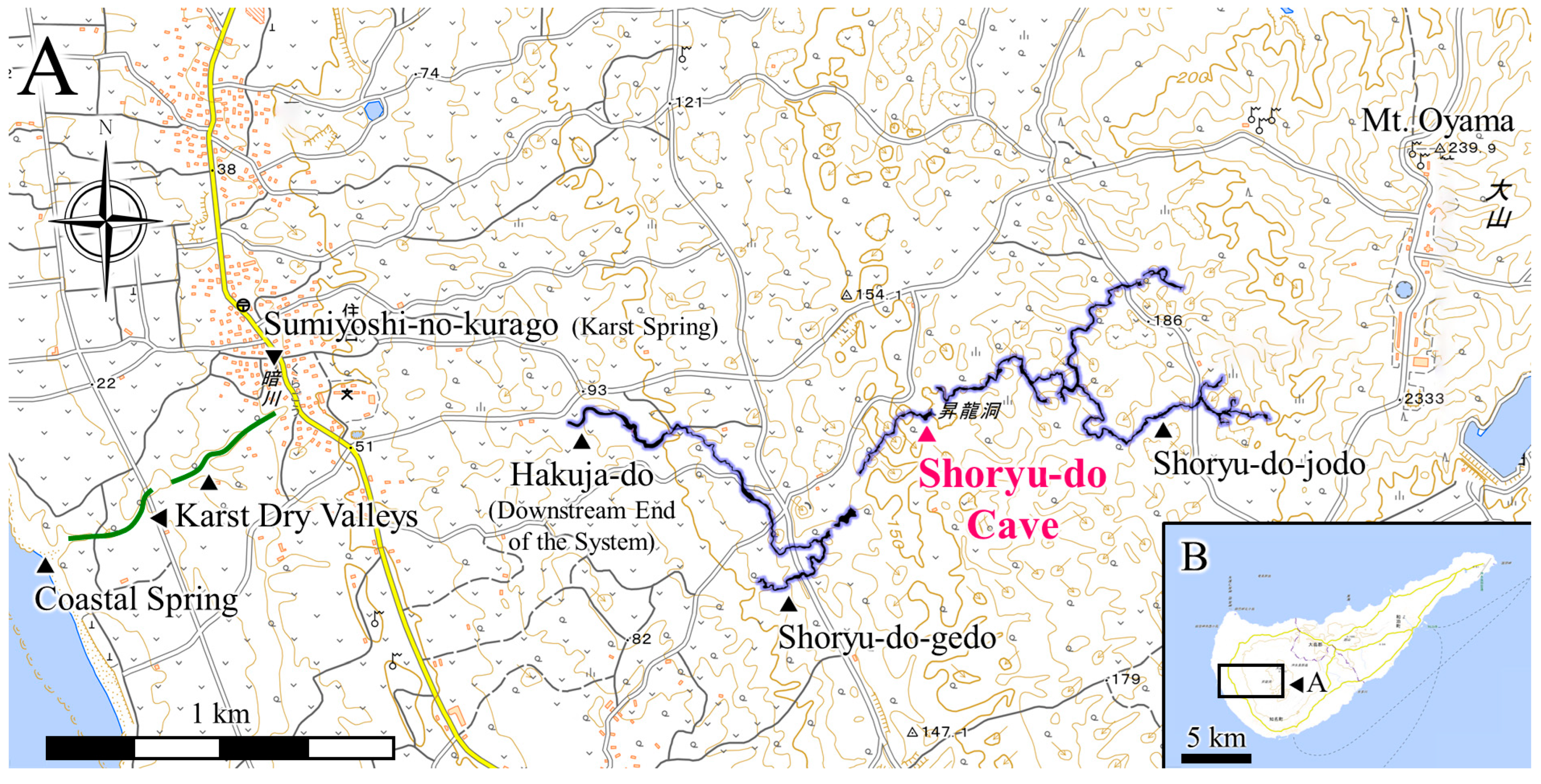
Shoryu-do on Okinoerabu Island is a limestone cave that opens at the bottom of a doline, approximately 1.6 km west-southwest of the summit of Mt. Oyama in China-cho, Kagoshima Prefecture (27.36250° N, 128.55241° E; Figure 23). It is a through cave with a total length of 490 m [165], and the entire cave is open to the public as a show cave. Adjacent to the upstream side of Shoryu-do is the “Shoryu-do Upper Cave” (Shoryu-do-jodo), which extends for 2047.3 m [166], and downstream, beyond a small cave called “Sango-do,” is the “Shoryu-do Lower Cave” (Shoryu-do-gedo), which extends more than 1300 m. These caves are considered originally to have been a single continuous system, later separated by the formation of collapse dolines, and are collectively referred to as the “Shoryu-do Cave System” (Figure 25). Including several other related small caves, the total cave system exceeds 4200 m in length.
The ceiling of Shoryu-do is composed of Ryukyu Limestone, while the cave walls expose conglomerate and sandstone [167]. The limestone belongs to the Pleistocene Ryukyu Limestone [168], and the conglomerate is interpreted as its basal deposit [165]. The clasts in the conglomerate are believed to have originated from basalts of the Cretaceous accretionary complex, specifically the Neori Formation, which crops out near the summit of Mt. Oyama. No clear fault systems have been identified in the cave formation [167], and the cave exhibits an extremely flat structure developed along the unconformity marking the boundary between the limestone and non-limestone layers.
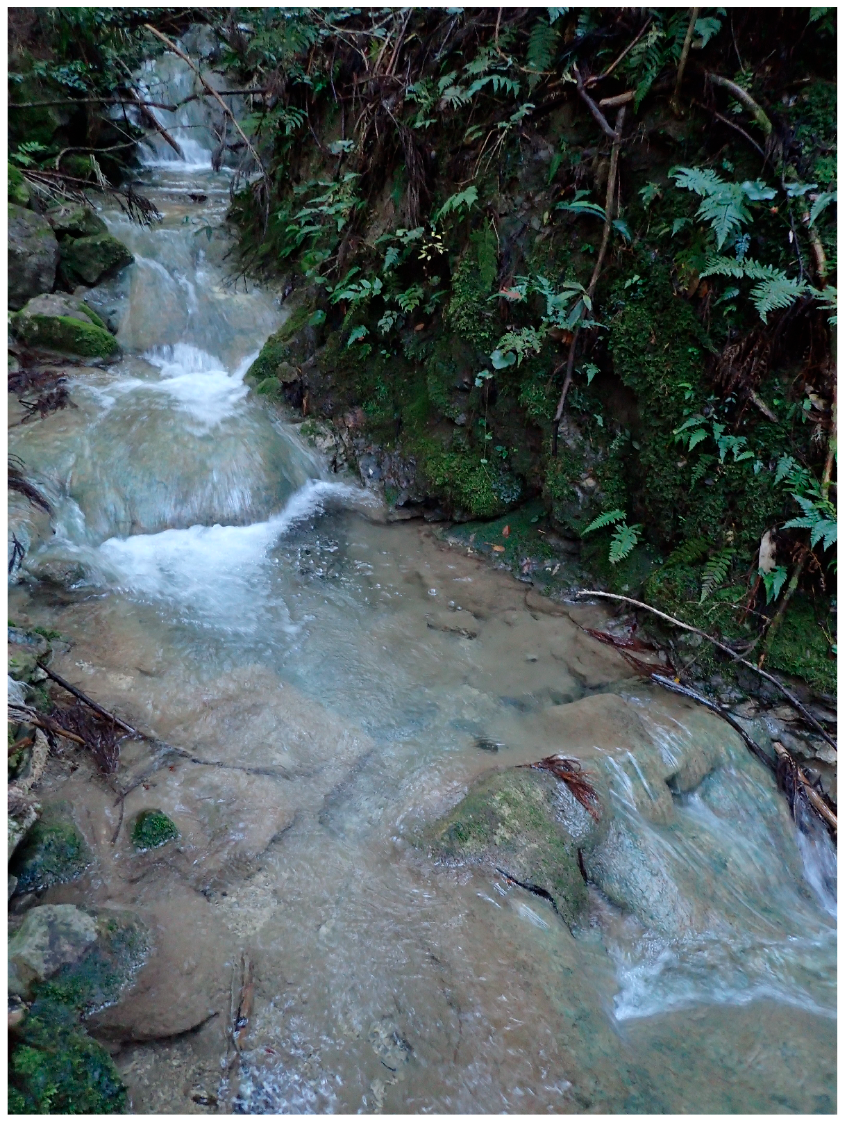
The Shoryu-do Cave System belongs to the same groundwater system. The section upstream from Sango-do is usually dry but transforms into a series of subterranean streams during high water conditions. The downstream end of Shoryu-do Lower Cave is known as “Hakuja-do,” which has a large and perennial water flow. At the innermost point lies a pool approximately 70 m in length and over 2 m in depth. Fluorescent dye tracing has confirmed that groundwater from Hakuja-do flows out from the karst spring called “Sumiyoshi-no-kurago” which is located within about 1 km west of the pool at the bottom of a doline [165]. The well-cemented reef limestone acts as a barrier to the underground river, causing its conduit to bend sharply along the boundary of the reef limestone. In contrast, at the downstream end in Hakuja-dō, a freely meandering canyon passage has developed within semi-consolidated sandy limestone.

4.4.2. Hakuho-Do Cave

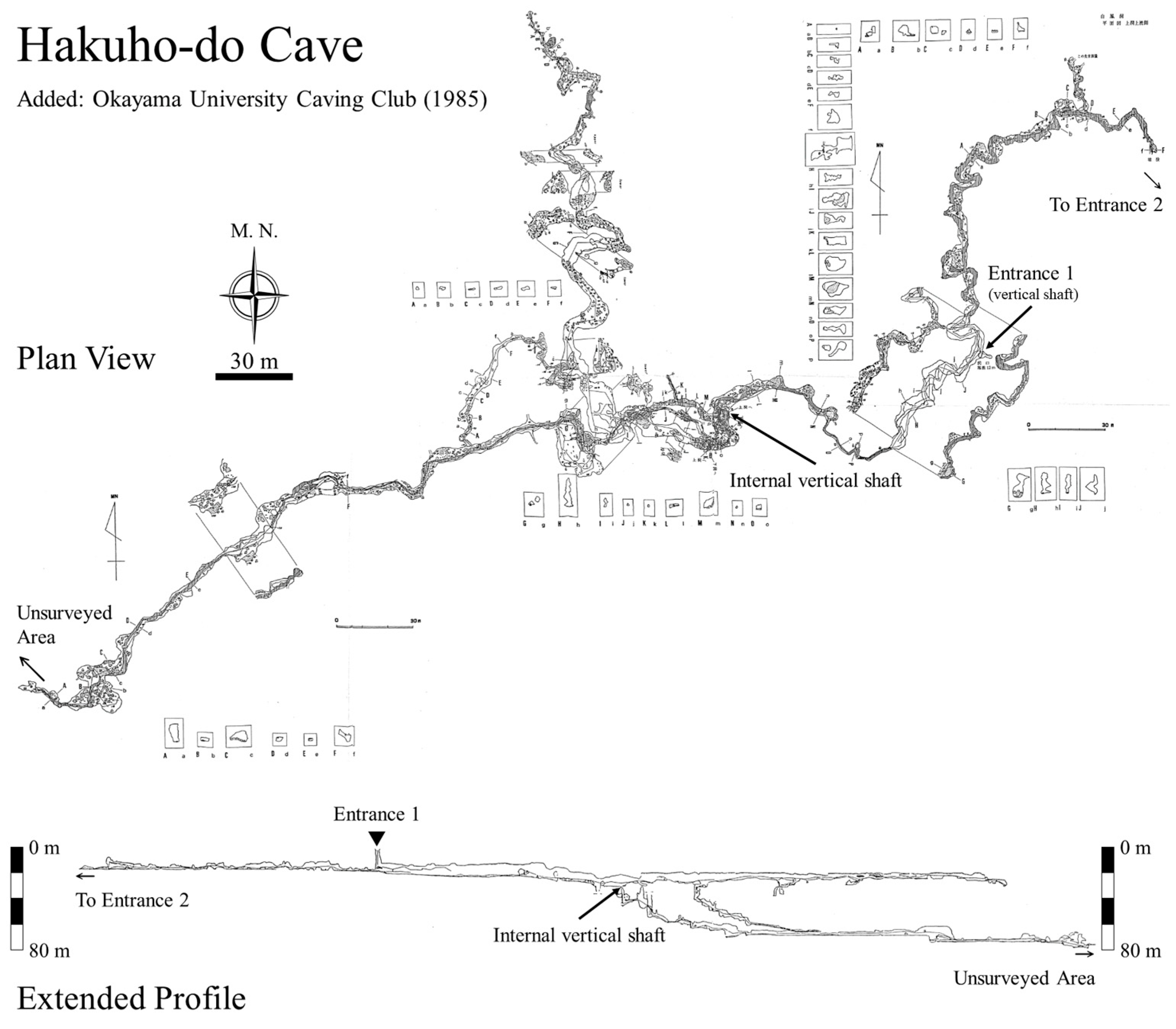
Hakuho-do Cave is a vertical-horizontal composite cave that opens at the bottom of a doline in the mountains approximately 1.6 km west of Mt. Oyama in Okinoerabu Island. The coordinates are withheld for conservation. The mapped extension is over 1585.9 m with a total vertical range of 80.4 m [169], though actual passage development is known to exceed 1 km further. The cave primarily consists of two horizontally developed levels (Figure 26).
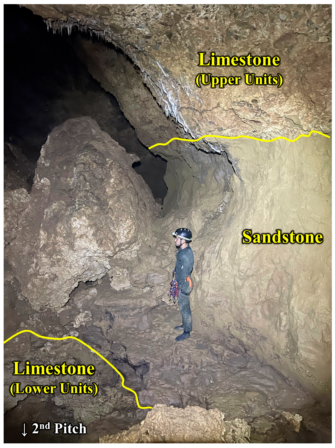
The primary entrance is a vertical shaft (First Pitch) with a height difference of about 17 m, located at the bottom of a doline formed in reef limestone. The shaft walls are composed of porous coral, making them prone to collapse. At the bottom of the shaft, a small subterranean stream flows southwest, meandering along the way where sandstone becomes exposed on the cave floor. Following a meander trench eroded into the sandstone leads to another vertical shaft (Second Pitch), about 25 m deep. Around the Second Pitch, sandstone layers are exposed up to 3 m above the cave floor (Figure 27), with limestone reappearing in the lower layer. The cave is divided at this shaft into upper and lower levels, and the boundary between the sandstone layers and the underlying limestone may represent the unconformity between the upper and lower units.
The limestone exposed at the bottom of the Second Pitch is whiter and more massive than the upper units, and a few three-dimensionally developed tube-like passages branch out. By descending several small steps from one of these passages, the underground river in the lower cave is reached. A very flat stream channel then extends southwest for several hundred meters. Beyond this hall, the cave continues as an unmapped, low-ceilinged passage. From this narrow, low passage, the underground river reappears and flows downstream for several hundred meters in a small valley. Based on its high discharge and position, this river may represent one of the sources of the Sumiyoshi-no-kurago spring.
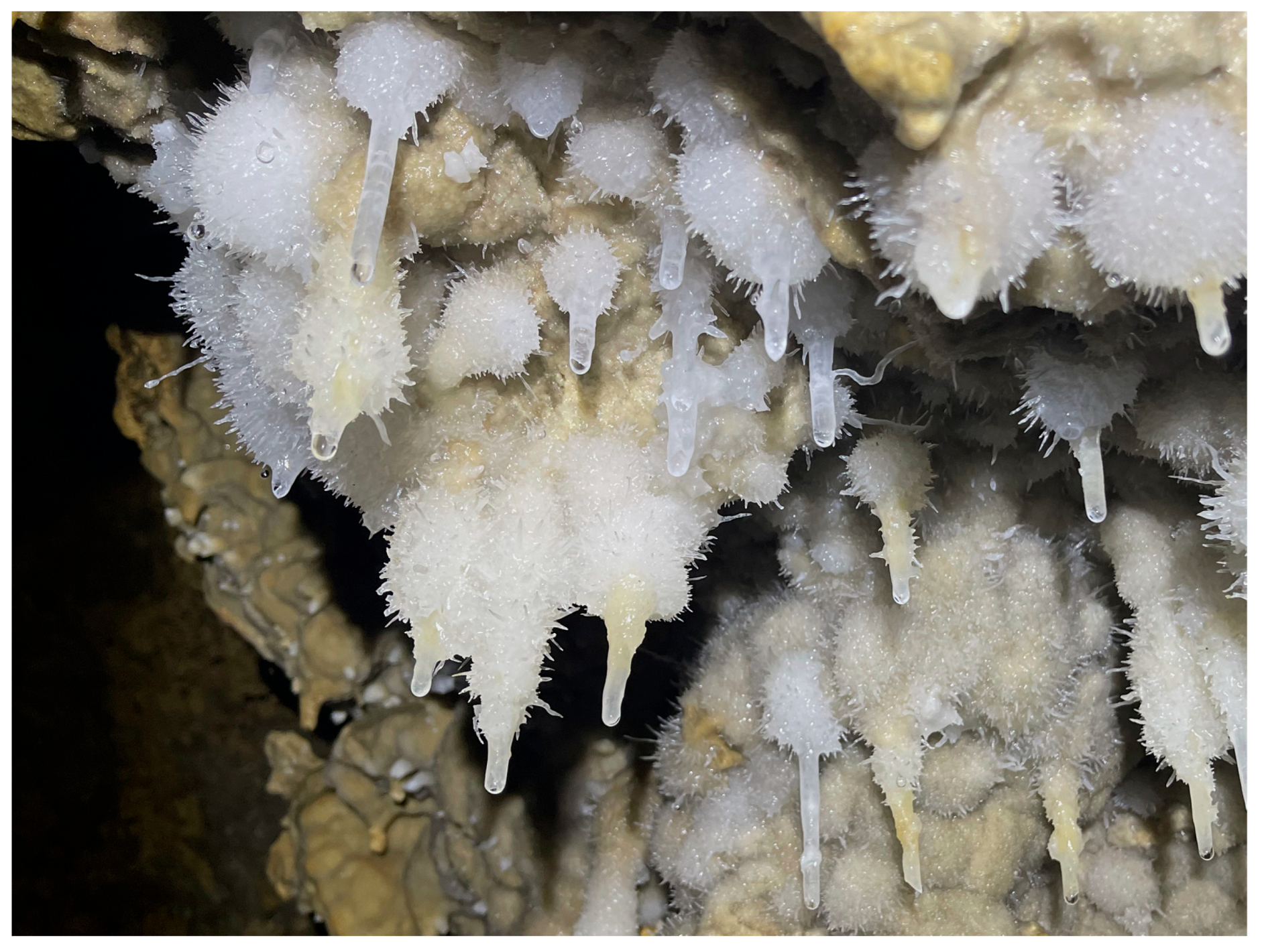
Some parts of the lower cave are densely lined with pure white and highly transparent speleothems. In particular, the chamber known as the “Hall of Hakuho” is renowned for its exceptionally clear speleothems, and the space, where limestone surfaces and speleothems are densely covered with clusters of helictites, is acclaimed as some of the most beautiful in Japan (Figure 28).
Hakuho-do Cave is a representative cave formed under the strong influence of the hydrogeological system shaped by the distinctive geological structures and lithofacies of the Ryukyu Group. Although the full extent of Hakuho-do is not yet known, further investigation of this cave is expected to significantly advance the understanding of karst formation on Okinoerabu Island and contribute to both scientific research and environmental conservation. The relationship between the geological structures and lithofacies of the Ryukyu Group and underground river caves in the Amami–Okinawa region has been reviewed [170].

4.4.3. Ginsui-Do Cave

Ginsui-do Cave is one of the largest caves on Okinoerabu Island, with a surveyed length of 2903.6 m and a vertical range of 58.4 m (Figure 29) [171]. It has two entrances (coordinates withheld for conservation). The upper entrance opens naturally at the bottom of a doline about 1.2 km northwest of the summit of Mt. Oyama, while the lower entrance is located on the southeastern slope of the Tamina area. The lower entrance, originally a natural vertical shaft, is now fitted with a manhole and is used for drainage from surrounding ditches.
At the doline bottom northwest of Mt. Oyama, mudstone of the Neori Formation (Late Cretaceous Shimanto accretionary complex) is exposed as a basement of the Ryukyu Limestone. A surface river flowing over the mudstone sinks underground at the upper entrance. The overlying limestone forms a boundary with the mudstone, along which the cave’s main conduit has developed [165]. The average gradient between the upper and lower ends of the cave is a gentle 43 m/km. Despite some meanders, and an approximately 5 m waterfall in the central part, the overall cave structure is remarkably flat with limited vertical relief. The cave floor is gradually incised by fluvial erosion, with the basal mudstone bedrock being eroded to form the cave walls and create a canyon-like passage (Figure 30).
In the upstream section, large amounts of clastic sediments and plant debris-derived mud flow into the cave. Approximately 350 m from the entrance, a constricted section occurs where the gap between the water surface dammed by sediments and the cave ceiling narrows to about 20 cm. Beyond this point, the cave expands in scale, with ceiling heights exceeding 20 m in places and giant speleothems becoming prominent. Especially notable is the flowstone near the aforementioned waterfall, which includes rimstone pools over 2 m deep (Figure 31). Its grandeur and pure whiteness are widely admired in Japan. The most downstream part of the cave is submerged, and on its northern side, several vertical shafts with a total height difference of about 25 m allow an ascent to a manhole that provides access to the surface.
About 0.6 km northwest of the submerged section of the lower stream of the Ginsui-do Cave, at the bottom of a doline within the Tamina settlement, is a karst spring called “Tamina-no-kurago”, which has associated upstream and downstream caves of approximately 190 m and 340 m in length, respectively. Groundwater flowing through these caves belongs to the same hydrological system as Ginsui-do, as confirmed by fluorescent dye tracing from the upper entrance, which emerges after approximately 24 h [171]. At the northwestern end of the downstream passage, the underground river again becomes submerged and inaccessible. The subsequent flow path remains uncertain, but a potential connection with a coastal spring about 2 km southwest of Cape Tamina, at the northwestern tip of the island, has been suggested [165]. If confirmed, the Ginsui-do system represents groundwater flowing directly into the sea via subterranean rivers and submerged caves.

4.4.4. Karst Development in Okinoerabu Island

The limestone of Okinoerabu Island is a Quaternary Pleistocene coral-reef–karst complex and a typical AAS. It can be broadly divided into two stratigraphic units of different ages, resulting from sea-level fluctuations. The limestone exhibits distinct bedding with numerous interbedded terrestrial clastic layers, which are particularly prominent at the boundaries of the two main units. The lower units were exposed during a low-stand and underwent karstification, whereas the upper units formed during the subsequent high-stand under marine transgression. Numerous subterranean river cave systems have developed along bedding planes, discontinuities, and contacts with basement rocks, forming extensive, planar cave networks. Many of these caves are submerged in their downstream sections, and they are inferred to connect to the sea via submarine conduits originating in the paleo-karst of the lower units.

4.5. Comparison of Karst Development in Representative Limestones in Japan

Significant differences in karst development are observed among Akiyoshidai, Seiyo (Shikoku), and Okinoerabu Island. In Akiyoshidai, the combination of massive, non-bedded AOR-type limestone and a complex three-dimensional fracture system has led to the development of doline karst and wide-area groundwater systems with phreatic caves serving as conduits. The Torinosu Limestone in Seiyo (Shikoku) is a lens-shaped AAS Limestone, where the development of three-dimensional fracture systems has produced maze-like caves, and the small, dispersed limestone bodies in the mountains give rise to numerous swallow holes and karst springs. The Ryukyu Limestone on Okinoerabu Island is a Quaternary Pleistocene coral-reef–karst complex and a typical AAS Limestone, where numerous dolines and karst dry valleys have formed on emerged coral-reef limestone, and subterranean river caves have developed along bedding planes, discontinuities, and contacts with basement rocks. These differences in limestone type, lithology, and fracture development largely control the variations in karst landforms, cave morphology, and groundwater system development in each region (Table 3).

5. Discussion

5.1. Formation History of Three Major AOR Limestones on the Oceanic Plate
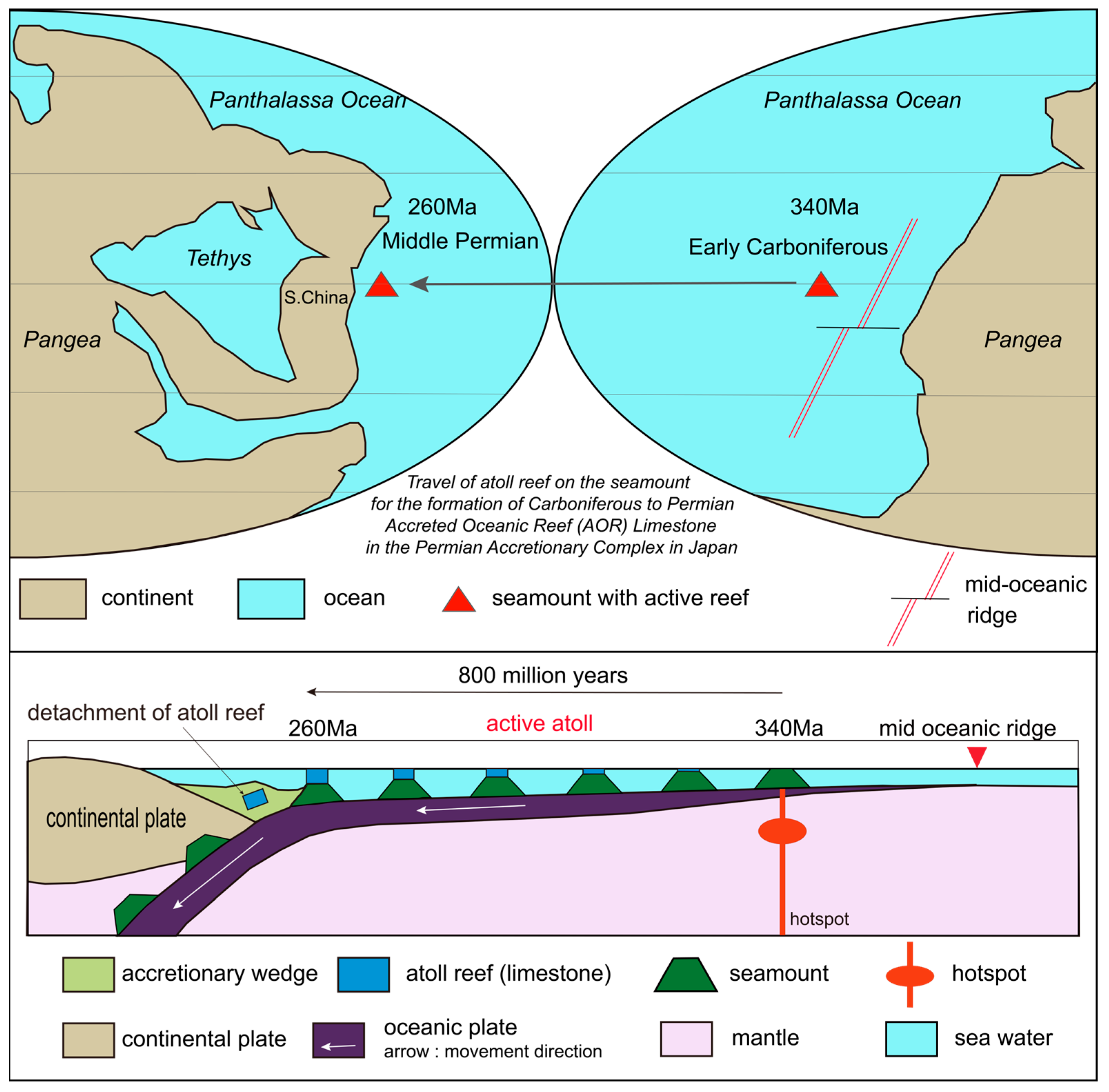
AOR Limestones in the Japanese Islands are typically found within Permian and Jurassic accretionary complexes. Both accretionary complexes are primarily composed of Late Paleozoic limestones, though the oceanic plate conditions during their formation differ slightly. This section examines the formation environments of AOR Limestones from these two time periods, based on various geological parameters.
The geological history of AOR Limestones in the Permian accretionary complex has been thoroughly documented for the Akiyoshi Limestone, a representative example, by [19]. The origin of these limestones lies in atolls that developed atop submarine volcanoes—erupted during the Early Carboniferous on an oceanic plate that was generated in the Late Devonian—on the seafloor of the Panthalassa Ocean. As the oceanic plate cooled over time, it became thicker, colder, and denser, causing subsidence of the seafloor and gradual submergence of the seamount summits. While the atolls also subsided along with the seamount summits, they maintained their growth near sea level due to the activity of reef-building organisms, allowing them to persist for approximately 80 million years. This scenario is significantly different from the Hawaiian Islands, where volcanic islands and their coral reefs subside below sea level about 15 million years after eruption, halting reef development [172], due to the northwestward movement of the Pacific Plate away from the hotspot (Figure 32).
Notably, despite their formation during the globally cold Permo-Carboniferous Icehouse period [173], these reefs continued to grow. This is likely because the oceanic plate carrying the reefs migrated westward near the equator. In fact, the oceanic plate hosting the Akiyoshi Limestone atoll is thought to have subducted into a trench located at the forearc of an island arc along the continental margin of the South China Block, which was situated near the equator at that time [18,19,55,174]. The subducting oceanic plate at that time has been interpreted as the Farallon Plate [55,175,176]. Other AOR Limestones in the Permian accretionary complex in Japan are also thought to have originated from atoll reefs formed atop the same hotspot-related volcanic chains as the Akiyoshi Limestone. Therefore, the geological history inferred for the Akiyoshi Limestone can likely be applied to these other limestones as well.
In contrast, AOR Limestones in the Jurassic accretionary complex often occur as structural blocks within mélanges. Their stratigraphic relationships with underlying rocks are unclear, and the internal stratigraphy of the limestone itself is often disrupted. As a result, total thicknesses are uncertain, and a complete geological reconstruction remains elusive.
However, some limestones have been better studied. The Ryozenzan Limestone, for example, lies directly atop Asselian basalts [60], while the Ibukiyama Limestone preserves fusuline fossil biostratigraphy from the Artinskian to the Capitanian stages [61,177]. Additionally, the Funafuseyama Limestone is estimated to have a restored stratigraphic thickness of approximately 550 m [63,64,65].
Figure 32. Formation process of AOR Limestones incorporated into the Permian accretionary complex, reconstructed on the oceanic plate. Paleogeographic base maps were created after [174].
Geosciences 15 00393 g032
Based on the oceanic plate subsidence curves of the GDH-1 model [178], the following reconstruction was proposed [41]: the AOR Limestones in the Jurassic accretionary complex were originally formed as reefs atop hotspot-related volcanic edifices that erupted on relatively young oceanic plates approximately 10 million years after formation at mid-ocean ridges [179]. These reefs developed over a period of roughly 20 million years during the Early to Middle Permian. Subsequently, the seamount summits submerged below sea level in the Late Permian, halting reef growth. Although the Jurassic accretionary complex formed continuously from about 200 to 145 Ma, many of the limestones were accreted around 170 Ma. This suggests that after submergence, the reef-capped seamounts were transported for approximately 10 million years before the reef structures were detached from the basaltic seamounts and incorporated into the accretionary prism in the Middle Jurassic (Figure 33).
This geological history resembles that of the Hawaiian Islands, where hotspot-generated seamounts migrate northwestward—not along the equator—and pass through tropical, subtropical, and eventually subarctic regions. Geological evidence suggests that during the Late Triassic to Late Jurassic, the tectonic elements comprising Japan were situated along the margin of the South China Block, likely north of 40° N paleolatitude [174,180]. Although this timeframe includes the Permian Warming and the Triassic Hothouse—periods of warm global climate suitable for reef-building organisms—the end-Permian mass extinction, triggered by a preceding cold event, severely impacted reef ecosystems. This likely prevented the recovery and continued growth of reefs from keeping pace with the subsidence of the oceanic plate.
Nonetheless, in the accretionary complexes of the earliest Cretaceous in Japan, limestones ranging from the Permian to Late Triassic are known. These generally lack abundant index fossils, and their stratigraphy remains poorly defined. However, the presence of Triassic limestones within the earliest Cretaceous accretionary complexes suggests that the associated reefs may have avoided the end-Permian reef extinction and were able to continue growing into the Triassic—unlike those incorporated into Jurassic accretionary complexes.
Figure 34 shows a reconstructed paleogeographic map illustrating the possible migration routes of reefs that formed the different limestones within the Panthalassa Ocean. The reefs that formed the Permian AOR Limestones likely migrated along routes nearly parallel to the equator, or along gently oblique paths from the Southern to the Northern Hemisphere.
In contrast, reefs that formed the Jurassic AOR Limestones likely migrated northward over about 55 million years, traversing from tropical through subtropical to subarctic zones. Reefs incorporated into the earliest Cretaceous accretionary complexes were still located in the tropics during the Triassic, suggesting a later northward migration than those of Jurassic age. Some Triassic limestones are directly deposited onto oceanic basalt [70,77], and many Late Triassic chert-basalt associations are also known in the Mino belt [59,181]. This implies that new hotspot-related magmatism during the Late Triassic may have created new seamounts upon which reefs subsequently developed.
Thus, although numerous limestone bodies are present in the Permian, Jurassic, and earliest Cretaceous accretionary complexes of Japan, the marine environments in which these reefs formed are inferred to have differed—even if formed during overlapping geological periods.

5.2. Karst Development in the Limestones of the Japanese Archipelago: Links to Tectonic History

Limestones in Japan can be classified into multiple types based on their depositional environments and geological settings. Accreted Oceanic Reef (AOR) Limestones were originally formed on remote oceanic islands or seamounts and are composed almost entirely of pure calcium carbonate. In contrast, Autochthonous Arc-Shelf (AAS) Limestones developed in shallow marine environments along island-arc margins and may include volcanic clastic or terrigenous sediments.
These limestones subsequently underwent accretion, uplift, and structural deformation, strongly influencing the development and spatial arrangement of karst landforms and cave systems. For example, caves formed within AOR Limestones tend to follow original bedding planes and faults or folds generated during accretion, highlighting the critical role of structural controls in speleogenesis. Consequently, the distinctive characteristics of Japanese karst landscapes and cave systems are explained not merely by limestone presence or climate, but through the temporal sequence: limestone formation → accretion and uplift → structural control → karstification. Understanding this causal chain is essential for interpreting the uniqueness of Japanese karst compared with continental-shelf carbonate terrains elsewhere.
Representative karst landforms were examined in both limestone types. Compared with karst terrains formed in Autochthonous Continental-Shelf (ACS) Limestones, which are widespread globally, Japanese examples are markedly smaller and exhibit more limited geomorphic development. Nevertheless, Japanese karst displays features of global significance. The AOR Limestones, exemplified by the Akiyoshi Limestone of the Akiyoshidai Karst Plateau, experienced only brief subaerial exposure. Consequently, large-scale tower karst (e.g., Guilin, China; Ha Long Bay, Vietnam) and cockpit karst (e.g., Cuba, Jamaica), typical of many ACS settings, are virtually absent. Instead, the surface of the Akiyoshidai Karst Plateau is dominated by extensive doline karst (doline fields).
Although lithologically homogeneous, AOR Limestones and Pre-Cenozoic AAS Limestones have been fractured and deformed by complex faulting and folding within an active orogenic belt at a convergent plate boundary. Karst landforms tend to develop along major tectonic lines and fault zones, which strongly control groundwater flow paths and cave morphology. Cave systems in Akiyoshi and Torinosu limestones form intricate three-dimensional networks, in stark contrast to the predominantly horizontal or stratiform cave systems common in many other karst regions (Figure 35). These characteristics likely result from rapid tectonic uplift and subsidence and from large fluctuations in the groundwater table.
Cenozoic AAS Limestones, typified by the Pleistocene Ryukyu Group (Ryukyu Limestone) in the Ryukyu Islands, are very young and uplifted reef limestones. Although frequently offset by faults, they lack the intense structural deformation characteristic of AOR Limestones and Pre-Cenozoic AAS Limestone. Formed on an island arc related to subduction of the Philippine Sea Plate and underlain by Mesozoic accretionary complexes, Ryukyu Limestone commonly contains interbedded terrigenous deposits such as mudstone. In this respect—albeit on a smaller scale—it resembles the depositional environments of ACS Limestones worldwide. Consequently, caves in Ryukyu Limestone are strongly controlled by intercalated mudstone layers and typically develop predominantly horizontal geometries (Figure 35).
In summary, Japanese karst landscapes reflect the combined influence of distinct depositional environments and subsequent tectonic modification in AOR and AAS Limestones. Although limited in scale, these landforms represent a distinctive subset of global karst terrains—notable for doline-dominated surfaces and the structural alignment of landforms. Cave systems exhibit contrasting geometries: AOR Limestones and Pre-Cenozoic AAS Limestones develop intricate three-dimensional networks that record active tectonic history, whereas Cenozoic AAS Limestones, like ACS analogues, typically form predominantly two-dimensional, horizontal networks (Figure 35). This overview underscores the causal linkage from limestone formation through accretion, uplift, and structural control to the development of unique karst landforms and cave systems in an active island-arc setting.

6. Summary and Conclusions

In this study, we propose a new classification of limestones based on their depositional environments and formation processes: Autochthonous Continental-Shelf (ACS) Limestones, Accreted Oceanic Reef (AOR) Limestones, and Autochthonous Arc-Shelf (AAS) Limestones. Whereas most limestones worldwide are of the ACS type, limestones in Japan are predominantly composed of the AOR and AAS types. Among them, AOR Limestones constitute the principal and most characteristic limestone formations in Japan.
Both types of limestones in Japan are restricted in their depositional settings and spatial distribution, resulting in relatively small limestone bodies. ACS and AAS Limestones, having formed in shallow marine environments adjacent to continental margins, often contain interbedded terrigenous clastic sediments. In contrast, the AOR Limestones—distinctive to Japan—originated from atoll reefs that developed atop isolated seamounts in the mid-Panthalassa Ocean, far from any terrestrial influence. Consequently, these rocks are composed almost entirely of pure calcium carbonate, with minimal to no clastic contamination.
Following their formation, these atoll limestones were transported via oceanic plate motion to subduction zones, where they were accreted onto the overriding plate and subsequently deformed within compressional tectonic settings along convergent plate boundaries. This extraordinary geological journey has given rise to karst landscapes in Japan that differ fundamentally from those developed on ACS Limestones in other parts of the world. The karst landforms observed in Japan are typified by relatively flat surfaces with doline-dominated topography (doline karst) and highly complex, densely developed three-dimensional cave systems, both of which are strongly controlled by tectonic deformation.
This synthesis demonstrates that limestones in Japan are fundamentally distinct from the dominant continental-shelf type carbonates (ACS). Nearly all major limestone bodies in Japan belong to either AOR or AAS types, reflecting the tectonic setting of an active convergent margin. Their limited areal extent, strong tectonic deformation, and close relationship with volcanic and clastic rocks stand in marked contrast to the broad, stable carbonate platforms of other continents. The associated karst landscapes also record these unique geological origins. Caves and karst landforms in Japan are highly localized, structurally controlled, and strongly influenced by rapid uplift, again differing from the extensive karst terrains developed on continental platforms.
Taken together, these findings highlight the global significance of limestones and karst landforms in Japan: they provide rare and well-preserved examples of reef-derived limestones accreted at convergent margins, offering key insights into the interactions of plate tectonics, oceanic volcanism, and carbonate sedimentation. While significant advances have been made in karst research worldwide, these uniquely evolved karst landscapes—shaped by Japan’s active tectonic setting and oceanic limestone origins—remain underexplored. Further detailed investigation of these systems, combined with global comparative studies, is expected to contribute new and important perspectives on the diversity and evolution of karst environments.

Author Contributions

Writing—original draft for Geology, K.W. and T.T. Writing—original draft for Geography; T.M., T.T. and K.U.; writing—review and editing, K.W., T.M. and T.T.; methodology, K.W.; visualization, K.W. and T.M.; supervision, K.W. All authors have read and agreed to the published version of the manuscript.

Funding

This research was funded by This research was supported by JSPS KAKENHI Grant Number, JP 23H03645.

Data Availability Statement

The original contributions presented in this study are included in the article; further inquiries can be directed to the corresponding author.

Acknowledgments

This research was supported by the Miné-Akiyoshidai Karst Plateau Geopark Promotion Council. Field survey assistance was provided by Tsukasa Takahashi, Takumi Sakakiyama (Shikoku Seiyo Geo Museum), the Shikoku Seiyo Geopark Promotion Council, Okinoerabujima Caving Association, and the Speleological Survey Group of Yamaguchi University. We thank Yuki Fujii (Ukigumo Caving Club) for providing the survey map of Hakuho-do Cave and Takechiyo Arikawa (Okinoerabujima Caving Tour NEXT) for the photograph of Ginsui-do Cave. Literature research support was provided by Kazuhiro Tanaka (Yamaguchi University) and Kenta Tanaka (Yamaguchi Junior College).

Conflicts of Interest

The authors declare no conflicts of interest.

References

  1. Ford, D.C. Karst geomorphology, caves and cave deposits: A review of North American contributions during the past half century. In Perspectives on Karst Geomorphology, Hydrology, and Geochemistry—A Tribute Volume to Derek C. Ford and William B. White; Harmon, R.S., Wicks, C.M., Eds.; GSA Special Paper 404: Boulder, CO, USA, 2006; pp. 1–12. [Google Scholar] [CrossRef]
  2. Parise, M.; Gabrovsek, F.; Kaufmann, G.; Ravbar, N. (Eds.) Recent advances in karst research: From theory to fieldwork and applications. In Advances in Karst Research: Theory, Fieldwork and Applicatios; Geological Society of London, Special Publication: London, UK, 2018; Volume 466, pp. 1–27. [Google Scholar] [CrossRef]
  3. Zerga, B. Karst topography: Formation, processes, characteristics, landforms, degradation and restoration: A systematic review. Watershed Ecol. Environ. 2024, 6, 252–269. [Google Scholar] [CrossRef]
  4. Sweeting, M.M. Karst in China—Its Geomorphology and Environment; Springer: Berlin/Heidelberg, Germany, 2012; 265p. [Google Scholar]
  5. Teibisz, T.; Mari, L. The significance of Karst areas in European national parks and geoparks. Open Geosci. 2020, 12, 117–132. [Google Scholar] [CrossRef]
  6. Gregorič, A.C. Typical Doline and Surface Landforms of Kras (Slovenia): Karst Landscape Features and Possibilities for Ther Conservation. Geoheritage 2021, 13, 26. [Google Scholar] [CrossRef]
  7. Jones, B. Void-filling deposits in karst terrains of isolated oceanic islands: A case study from Tertiary carbonates of the Cayman Islands. Sedimentology 1992, 39, 857–876. [Google Scholar] [CrossRef]
  8. Mylroie, J.E. Karst Features of Guam in terms of a general model of carbonate island karst. J. Cave Karst Strudies 2001, 63, 9–22. [Google Scholar]
  9. Jones, I.C.; Banner, J.L. Estimating recharge thresholds in toropical karst island aquifers: Barbados, Puerto Rico and Guam. J. Hydrol. 2003, 278, 131–143. [Google Scholar] [CrossRef]
  10. Jones, I.C.; Banner, J.L. Hydrogeologic and climatic influences on spatial and interannual variation of recharge to a tropical karst island aquifer. Water Resour. Res. 2003, 39. [Google Scholar] [CrossRef]
  11. Jenson, J.W.; Keel, T.M.; Mylroie, J.R.; Mylroie, J.E.; Stafford, K.W.; Tabrosi, D.; Wexel, C. Karst of the Mariana Islands: The interaction of tectonics, glacio-eustasy, and freshwater/seawater mixing in island carbonates. In Perspectives on Karst Geomorphology, Hydrology, and Geochemistry—A Tribute Volume to Derek C. Ford and William B. White; Harmon, R.S., Wicks, C.M., Eds.; Geological Society of America, Special Paper 404: Boulder, CO, USA, 2006; pp. 129–138. [Google Scholar] [CrossRef]
  12. Guidry, S.A.; Gramueck, M.; Carpenter, D.G.; Gomobos, A.M.; Bachtel, S.L.; Viggiano, D.A. Karst and Early Fracture Networks in Carbonates Turks and Caicos Island British West Indies. J. Sediment. Res. 2007, 77, 508–524. [Google Scholar] [CrossRef]
  13. Malago, A.; Efstathiou, D.; Bouraoui, F.; Nikolaidis, N.P.; Franchini, M.; Bidoglio, G.; Kritsotakis, M. Regional cale hydrologic modeling of a karst-dominant geomorphology: The case study of the Island of Crete. J. Hydorology 2016, 540, 64–81. [Google Scholar] [CrossRef]
  14. Knez, M.; Slabe, T.; Urushibara-Yoshino, K. Lithology, rock relief and karstification of Minamidaito Island (Japan). Acta Carsologica 2017, 45, 47–62. [Google Scholar] [CrossRef]
  15. Mylroie, J.E.; Vacher, H.L. A Conceptual View of Carbonate Island Karst. In Karst Modelling; Palmer, M.V., Sawowsky, I.D., Eds.; Karst Water Institute Special Publication: Lewisburg, PA, USA, 1999; Volume 5, pp. 48–57. [Google Scholar]
  16. Mylroie, J.E.; Carew, J.L. Karst Development on carbonate islands. In Speleogenesis and Evolution of Karst Aquifers; The American Association of Petroleum: Tulsa, OK, USA, 2003; Volume 1, pp. 1–21. [Google Scholar]
  17. Mylroie, J.R.; Mylroie, J.E. Development of the Carbonate Island Karst Model. J. Cave Karst Stud. 2007, 69, 59–75. [Google Scholar]
  18. Wakita, K.; Obara, H.; Oyama, N.; Murakami, T. Reassessing the Global Significance of Geological Heritages in the Miné-Akiyoshidai Karst Plateau Geopark. Geosciences 2025, 15, 56. [Google Scholar] [CrossRef]
  19. Wakita, K.; Nakagawa, T.; Sakata, M.; Tanaka, N.; Oyama, N. Phanerozoic accretionary history of Japan and the western Pacific margin. Geol. Mag. 2021, 158, 13–29. [Google Scholar] [CrossRef]
  20. Kato, Y.; Iwata, K.; Uozumi, S.; Nakamura, K. Re-examination on the Pre-Tertiary System distributed in the Toma-Kaimei district of central Hokkaido. J. Geol. Soc. Jpn. 1986, 92, 239–242. (In Japanese) [Google Scholar] [CrossRef]
  21. Ueda, H. Geologic structure of Cretaceous accretionary complexes in the frontal Hidaka collision zone, Hokkaido, Japan. J. Geol. Soc. Jpn. 2006, 112, 699–717, (In Japanese with English Abstract). [Google Scholar] [CrossRef]
  22. Kanmera, K.; Sano, H. Stratigraphic and structural relationships among pre-Jurassic accretionary and collisional systems in Akiyoshi Terrane. In Guidebook for Excursion, International Symposium on Pre-Jurassic East Asia, IGCP Project 224; Nippon Insatsu: Osaka, Japan, 1986; pp. 51–88. [Google Scholar]
  23. Kanmera, K.; Sano, H.; Isozaki, Y. Akiyoshi Terrane. In Pre-Cretaceous Terranes of Japan; Ichikawa, K., Mizutani, S., Hara, I., Hada, S., Yao, A., Eds.; Publication of IGCP Project 224; Nippon Insatsu Shuppan: Osaka, Japan, 1990; pp. 49–62. [Google Scholar]
  24. Sano, H.; Sugiyama, T.; Nagai, K.; Ueno, K.; Nakazawa, T.; Fujikawa, M. Carboniferous to Permian paleoenvironmental changes revealed in Akiyoshi Limestone—Commemorating field excursion for the 50th anniversary of the foundation of Akiyoshi-dai Museum of Natural History. J. Geol. Soc. Jpn. 2009, 115, S71–S88. [Google Scholar] [CrossRef]
  25. Wakita, K.; Kametaka, M. Beyond the Akiyoshi Orogeny: Unravelling overturned structures and tectonic processes in the Permian accretionary complex of the Mine-Akiyoshidai area, Yamaguchi, western Japan. J. Geol. Soc. 2024, 181, jgs2023-170. [Google Scholar] [CrossRef]
  26. Sano, H.; Hayasaka, Y.; Tazaki, K. Geochemical characteristics of Carboniferous greenstones in the Inner Zone of Southwest Japan. Island Arc 2000, 9, 81–96. [Google Scholar] [CrossRef]
  27. Tatsumi, Y.; Kani, T.; Ishizuka, H.; Maruyama, S.; Nishimura, Y. Activation of Pacific mantle plumes during the Carboniferous: Evidence from accretionary complexes in southwest Japan. Geology 2000, 28, 580–582. [Google Scholar] [CrossRef]
  28. Safonova, I.; Kojima, S.; Nakae, S.; Romer, R.L.; Seltmann, R.; Sano, H.; Onoue, T. Oceanic island basalts in accretionary complexes of SW Japan: Tectonic and petrogenetic implications. J. Asian Earth Sci. 2015, 113, 508–523. [Google Scholar] [CrossRef]
  29. Sada, K. The summary of the fusulinacean studies on the Carboniferous-Permian Taishaku Limestone in Hiroshima Prefecture, Japan. In Hiroshima Bunka Gakuen University Network Society Research Center Annual Research Report; Hiroshima Bunka Gakuen University: Hiroshima, Japan, 2014; Volume 10, pp. 1–12, (In Japanese with English Abstract). [Google Scholar]
  30. Sada, K. On the Upper Permian Fusulinid Fauna in the Atetsu Limestone Plateau, Okayama Prefecture. J. Geol. Soc. Jpn. 1960, 66, 410–425, (In Japanese with English Abstract). [Google Scholar] [CrossRef]
  31. Yamashita, M.; Ishiga, H. Correlation between the radiolarian and the fusulinacean biostratigraphy of the upper Middle Permian in Atetsu Plateau, Okayama Prefecture, Southwest Japan. J. Geol. Soc. Jpn. 1990, 96, 687–689. (In Japanese) [Google Scholar] [CrossRef]
  32. Yokoyama, T.; Hase, A.; Okimura, Y. Sedimentary Facies of Koyama Limestone. J. Geol. Soc. Jpn. 1979, 85, 11–25, (In Japanese with English Abstract). [Google Scholar] [CrossRef]
  33. Yokoyama, T. Sedimentary Facies of Nakamura Limestone. Chikyuukagaku (Earth Sci.) 1980, 34, 20–332, (In Japanese with English Abstract). [Google Scholar]
  34. Fujimoto, M.; Sada, K.; Oho, Y. Stratigraphy of the Shimodani Limestone in the southwestern part of the Oga area, Okayama Prefecture, western Japan. Fossils 1995, 58, 28–36, (In Japanese with English Abstract). [Google Scholar] [CrossRef]
  35. Murata, A.; Maekawa, H. Geological structures of the Torigatayama-Onogahara limestone and the Younger Ino metamorphic complex of the Chichibu Terrain, West Shikoku. Nat. Sci. Rearch Inst. Socio-Arts Sci. Univ. Tokushima 2013, 27, 91–100, (In Japanese with English Abstract). [Google Scholar]
  36. Kashima, N. New occurrence of fossils in the Ōnogahara area, Ehime Prefecture. J. Geol. Soc. Jpn. 1960, 66, 52. (In Japanese) [Google Scholar] [CrossRef]
  37. Kashima, N. Geology of the Oonogahara area, western Shikoku—Ukeana Melange. In Proceedings of the 105th Annual Meeting of the Geological Society of Japan, Matsumoto, Japan, 25–27 September 1998. [Google Scholar]
  38. Nakazawa, T. Sedimentary environments and reef-builders in the Carboniferous of the Omi Limestone Group. J. Geol. Soc. Jpn. 1997, 103, 849–868, (In Japanese with English Abstract). [Google Scholar] [CrossRef]
  39. Takeuchi, M.; Takenouchi, K.; Nakazawa, T. Geological exploration tour of the Itoigawa Geopark. J. Geol. Soc. Jpn. 2010, 116, S123–S142. [Google Scholar] [CrossRef]
  40. Fujikawa, M.; Nakazawa, T.; Ueno, K. Sedimentation and karstification of the Carboniferous-Permian Akiyoshi Limestone in the Akiyoshi accretionary complex. J. Geol. Soc. Jpn. 2019, 125, 609–631. (In Japanese) [Google Scholar] [CrossRef]
  41. Wakita, K. Tectonic setting required for the preservation of sedimentary mélanges in Palaeozoic and Mesozoic accretionary complexes of southwest Japan. Gondwana Res. 2019, 74, 90–100. [Google Scholar] [CrossRef]
  42. Murata, A. Chichibu Belt. In Regional Geology of Japan, Shikoku Region; Geological Society of Japan, Ed.; Asakura Publishing Co., Ltd.: Tokyo, Japan, 2016; pp. 103–201. [Google Scholar]
  43. Matsuoka, A.; Yamakita, S.; Sakakibara, M.; Hisada, K. Unit division for the Chichibu Composite Belt from a view point of accretionary tectonics and geology of western Shikoku, Japan. J. Geol. Soc. Jpn. 1988, 104, 634–653, (In Japanese with English Abstract). [Google Scholar] [CrossRef]
  44. Tazaki, K.; Sano, S.; Nagao, T.; Kasjima, N. Greenstones from Shikoku Karst: Comparative petrochemical study with basal greenstones of limestone plateau at Akiyoshi and Taishaku, Chugoku belt, southwest Japan. J. Mineral. Petrol. Econ. Geol. 1994, 89, 373–389, (In Japanese with English Abstract). [Google Scholar] [CrossRef]
  45. Hirata, M. Some Important New Facts from the Chichibu Zone of the Central Part of Shikoku. Chikyuu Kagaku (Earth Sci.) 1954, 36, 22–24, (In Japanese with English Abstract). [Google Scholar] [CrossRef]
  46. Hirata, M. Geology of Ohnogahara and Torigatayama areas. Chigaku Kenkyu (J. Geosci.) 1961, 12, 35–41. (In Japanese) [Google Scholar]
  47. Ishizaki, K. Stratigraphical and Paleontological Studies of the Onogahara and Its Neighbouring Area, Kochi and Ehime Prefectures, Southwest Japan. Ph.D. Thesis, Tohoku University, Sendai, Japan, 1962. [Google Scholar]
  48. Sakagami, S.; Kikukawa, T.; Shiraishi, K. Biostratigraphic study of the “Shikoku Karst” limestone-1—Fusulinacean fossils between Jiyoshi Pass and Godanjo. Mem. Ehime Univ. Nat. Sci. Ser. D Earth Sci. 1975, 7, 89–94. [Google Scholar]
  49. Kashima, N. Stratigraphical studies of the Chichibu Belt in Western Shikoku. Mem. Fac. Sci. Kyushu Univ. Ser. D Geol. 1969, 19, 387–436. [Google Scholar] [CrossRef]
  50. Kashima, N. Geology of the Onogahara area in western Shikoku—Proposal of Ukiana Melange. In Prof. Naruhiko Kashima Memorial Paper Collection; Retirement Commemorative Project Meeting of Prof. Aihiko Kashima; Ehime Geoscience Research Association: Ehime, Japan, 2000; pp. 1–15. [Google Scholar]
  51. Shikoku Geotechnical Consultants Association, Ehime Branch. On-Site Training Materials, Jiyoshi Tunnel No.1 Construction; Shikoku Geotechnical Consultants Association, Ehime Branch: Shikoku, Japan, 2005. (In Japanese) [Google Scholar]
  52. Tsuji, T.; Sakakibara, M. Large-scale overturned structure of the Northern Chichibu Belt in western Shikoku, Southwest Japan. J. Geol. Soc. Jpn. 2009, 115, 1–16, (In Japanese with English Abstract). [Google Scholar] [CrossRef]
  53. Tsuji, T. Geological Research of the Northern Chichibu Belt in Western Shikoku, Southwest Japan: Tectonic Modification of Accretionary Complexes by Orogenic Movement at Convergent Margins. Ph.D. Thesis, Graduate School of Science and Engineering Ehime University, Matsuyama, Japan, 2014; pp. 1–177, (In Japanese with English Abstract). [Google Scholar]
  54. Wakita, K.; Metcalfe, I. Ocean Plate Stratigraphy in East and Southeast Asia. J. Asian Earth Sci. 2005, 24, 679–702. [Google Scholar] [CrossRef]
  55. Isozaki, Y.; Maruyama, S.; Aoki, K.; Nakamura, T.; Miyashita, A.; Otoh, S. Geotectonic Subdivision of the Japanese Islands Revisited: Categorization and Definition of Elements and Boundaries of Pacific-type (Miyashiro-type) Orogen. J. Geogr. 2010, 119, 999–1053, (In Japanese with English Abstract). [Google Scholar] [CrossRef]
  56. Wakita, K. Mappable features of mélanges derived from Ocean Plate Stratigraphy in the Jurassic accretionary complexes of Mino and Chichibu terranes in Southwest Japan. Tectonophysics 2012, 568–569, 74–85. [Google Scholar] [CrossRef]
  57. Wakita, K. Geology and Tectonics of the Japanese Islands: A review—The key to understanding the geology of Asia. J. Asian Earth Sci. 2013, 72, 75–87. [Google Scholar] [CrossRef]
  58. Wakita, K. OPS mélange: A new term for mélanges of convergent margins of the world. Int. Geol. Rev. 2015, 57, 529–539. [Google Scholar] [CrossRef]
  59. Wakita, K. Origin of chaotically mixed bodies in the Early Jurassic to Early Cretaceous sedimentary complex of the Mino terrane, Central Japan. Bull. Geol. Surv. Jpn. 1988, 39, 675–757. [Google Scholar]
  60. Miyamura, M.; Mimura, K.; Yokoyama, T. Geology of the Hikonetobu District, Geological Map at a scale of 1:50,000; Geological Survey of Japan: Tsukuba, Japan, 1976; (In Japanese with English Abstract). [Google Scholar]
  61. Kobayashi, M. On some new species of Rauserella from Mt. Ibuki, Shiga Prefecture, central Japan. Trans. Proc. Palaeontol. Soc. Jpn. New Ser. 1956, 23, 225–228. [Google Scholar]
  62. Kobayashi, F. Permian fusuline faunas and biostratigraphy of the Akasaka Limestone (Japan). Rev. Paléobiol. 2011, 30, 431–574. [Google Scholar]
  63. Kobayashi, F. Middle Permian fusulines from the Funabuseyama area, Mino terrane, central Japan. Hum. Nat. 2021, 31, 1–40. [Google Scholar] [CrossRef]
  64. Sano, H. Permian Oceanic-Rocks of Mino Terrane, Central Japan, Part II. Limestone Facies. J. Geol. Soc. Jpn. 1988, 94, 963–976. [Google Scholar] [CrossRef]
  65. Sano, H.; Yamagata, T. Stratigraphy and age of the oceanic rocks of the Mino Belt in the Funafuseyama area. J. Geol. Soc. Jpn. 2020, 126, 365–381. (In Japanese) [Google Scholar] [CrossRef]
  66. Horibo, K. Petrography and depositional environment of Permian limestone of Mino terrane, Gujo-Hachiman, Gifu Prefecture, central Japan. J. Geol. Soc. Jpn. 1990, 96, 437–451, (In Japanese with English Abstract). [Google Scholar] [CrossRef]
  67. Kobayashi, F. Petrography and sedimentary environment of the Permian Nabeyama limestone in the Kuzuu area, Tochigi Prefecture, central Japan. J. Geol. Soc. Jpn. 1979, 10, 627–642. [Google Scholar] [CrossRef]
  68. Kobayashi, F. Middle Permian foraminifers of the Izuru and Nabeyama Formations in the Kuzu area, central Japan, Part 1, Schwagerinid, neoschwagerinid and verbeekinid fusulinoideans. Paleontol. Res. 2006, 85, 37–59. [Google Scholar] [CrossRef]
  69. Kobayashi, F. Middle Permian foraminifers of the Izuru and Nabeyama Formations in the Kuzu area, central Japan, Part 2, Schubertellid and ozawainellid fusulinoideans, and non-fusulinoidean foraminifers. Paleontol. Res. 2006, 10, 61–77. [Google Scholar] [CrossRef]
  70. Sugimoto, M.; Uda, S. On the Minor Structure of the Akka Limestone, Northern Kitakami Massif, Northeast Honshu, Japan. Bull. Kanazawa Univ. 1973, 22, 109–119, (In Japanese with English Abstract). [Google Scholar]
  71. Sano, S.; Sugiyama, N.; Shimaguchi, T. Discovery of megalodontoid bivalves in the Shiriya area, northern Honshu, Northeast Japan, and its geological implications. Mem. Fukui Prefect. Dinosaur. Mus. 2009, 8, 51–57, (In Japanese with English Abstract). [Google Scholar]
  72. Ota, A.; Kanmera, K.; Isozaki, Y. Stratigraphy of the Permian Iwato and Mitai Formations in the Kamura area, Southwest Japan: Maokouan, Wuchiapingianm and Changhsingian carbonates formed on paleo-seamount. J. Geol. Soc. Jpn. 2000, 106, 853–864, (In Japanese with English Abstract). [Google Scholar] [CrossRef]
  73. Kobayashi, F. Late Permian (Lopingian) Foraminifers from the Tsukumi Limestone, Southern Chichibu terrane of eastern Kyhshu, Japan. J. Foraminifer. Res. 2013, 43, 154–169. [Google Scholar] [CrossRef]
  74. Kanmera, K.; Furukawa, H. Stratigraphy of the Upper Permian and Triassic Konose Group, of the Sambosan belt in Kyushu. Bull. Fac. Sci. Kyushu Univ. 1964, 6, 237–258, (In Japanese with English Abstract). [Google Scholar]
  75. Igo, H. Conodonts, as a new index fossil in Japan. J. Geogr. 1972, 81, 142–151, (In Japanese with English Abstract). [Google Scholar] [CrossRef]
  76. Fujimoto, H. On the distribution of limestones in the Kanto Mountains. Gypsum Lime 1974, 29–36. Available online: https://www.jstage.jst.go.jp/article/mukimate1953/1974/128/1974_128_29/_pdf (accessed on 26 September 2025). (In Japanese).
  77. Tominaga, K.; Hisada, K.; Taniguchi, H.; Machida, S.; Yasukawa, K.; Kato, Y. Major and Trace element composition of the “Utozawa Schalstein” underlying the Bukozan Limestone in the Kanto Mountains, central Japan. In Proceedings of the 123th Annual Meeting of the Geological Society of Japan, Tokyo, Japan, 10–12 September 2016. (In Japanese). [Google Scholar]
  78. Kawamura, T.; Oyama, Y.; Hikichi, A.; Suino, Y.; Sasaki, K.; Kon-no, T.; Takano, Y. Revisiting Silurian stratigraphy of the Hikoroichi area, South Kitakami Terrane. Bull. Miyagi Univ. Educ. 2021, 56, 173–185, (In Japanese with English Abstract). [Google Scholar]
  79. Niikawa, I. Biostratigraphy and correlation of the Onimaru Formation in the southern Kitakami Mountains, Part I Geology and biostratiraphy. J. Geol. Soc. Jpn. 1983, 89, 347–357, (In Japanese with English Abstract). [Google Scholar] [CrossRef]
  80. Kano, A. Facies and Depositional Conditions of a Carbonate Mound (Tithonian-Berriasian, SW-Japan). Facies 1988, 18, 27–47. [Google Scholar] [CrossRef]
  81. Iryu, Y.; Nakamori, T.; Yamada, T. A unit of lithostratigraphic classification of the Ryukyu Group, Pleistocene reef complex deposits. J. Sedimentol. Soc. Jpn. 1992, 36, 57–66, (In Japanese with English Abstract). [Google Scholar] [CrossRef]
  82. Ehiro, M. 4.2. South Kitakami Belt, 4.2.2. Lower and Middle Paleozoic. In Editorial Committee of “Tohoku District”; Asakura Publishing Company Ltd.: Tokyo, Japan, 2017; pp. 185–195. [Google Scholar]
  83. Kurata, N. Geology of the Togano Basin and its Vicinity, Kochi Prefecture, with Special Reference to the Stratigraphy of the Torinosu Series. J. Geol. Soc. Jpn. 1940, 47, 507–516, (In Japanese with English Abstract). [Google Scholar] [CrossRef]
  84. Kimura, T. The Torinosu Group and the Torinosu Limestone in the Togano and Go Basins, Kochi Prefecture. J. Geol. Soc. Jpn. 1956, 62, 515–526, (In Japanese with English Abstract). [Google Scholar] [CrossRef]
  85. Yao, A.; Matsuoka, A.; Nakatani, T. Triassic and Jurassic radiolarian assemblages in Southwest Japan. News Osaka Micropaleontol. Spec. Vol. Proc. First Jpn. Radiol. Symp. 1982, 5, 27–43, (In Japanese with English Abstract). [Google Scholar]
  86. Aita, Y.; Okada, H. Radiolarians and calcareous nannofossils from the uppermost Jurassic and Lower Cretaceous strata of Japan and Tethyan regions. Micropaleontology 1986, 32, 97–128. [Google Scholar] [CrossRef]
  87. Ishida, K.; Kozai, T. Stratigraphy and tectonic subdivision of the Chichibu Superbelt in East Shikoku. Nat. Sci. Res. Fac. Integr. Arts Sci. Univ. Tokushima 2003, 16, 11–41, (In Japanese with English Abstract). [Google Scholar]
  88. Tamura, M. A stratigraphic study of the Torinosu Group and its relatives. Mem. Fac. Educ. Kumamoto Univ. 1960, 8, 1–40, (In Japanese with English Abstract). [Google Scholar]
  89. Kano, A.; Jiju, K. The Upper Jurassic-Lower Cretaceous carbonate-terrigenous succession and the development of a carbonate mound in western Shikoku, Japan. Sediment. Geol. 1995, 99, 165–178. [Google Scholar] [CrossRef]
  90. Tamura, M. The geologic history of the Torinosu Epoch and the Mesozoic reef-limestone in Japan. Jpn. J. Geol. Geogr. 1961, 32, 253–278. [Google Scholar]
  91. Nakagawa, K.; Suyari, K.; Ichikawa, K.; Ishii, K.; Yamashita, N. Geology of Kurosegawa District, Ehime Prefecture (Studies on the Chichibu-Terrain in Shikoku, 4). J. Gakugei Tokushima Univ. (Nat. Sci.) 1959, 9, 33–58, (In Japanese with English Abstract). [Google Scholar]
  92. Takei, M.; Matsuoka, A. Megafossil-bearing mudstone blocks in the Oriai Formation of the Upper Jurassic Imaidani Group in the Shirokawa area, Ehime Prefecture, Southwest Japan. J. Geol. Soc. Jpn. 2004, 110, 146–157, (In Japanese with English Abstract). [Google Scholar] [CrossRef]
  93. Takayasu, K. “Ryukyu Limestone” of Okinawa-jima, South Japan―A Stratigraphical and Sedimentological Study. Memoiors Fac. Sci. Kyoto Univ. Ser. Geol. Mineral. 1978, XLV, 133–175. [Google Scholar]
  94. Kizaki, K. Geology and Tectonics of the Ryukyu Islands. Tectonophysics 1986, 125, 193–207. [Google Scholar] [CrossRef]
  95. Kaneko, N. Cenozoic stratigraphy of Okinawa Island and Ryukyu Arc. Chishitsu News 2007, 633, 22–30. (In Japanese) [Google Scholar]
  96. Nakae, S.; Kaneko, N.; Miyazaki, K.; Ohno, T.; Komazawa, M. Yoron Jima and Naha, Geological Map of Yoron Jima and Naha, 1:200,000; Geological Survey of Japan, AIST: Tsukuba, Japan, 2010; (In Japanese with English Abstract). [Google Scholar]
  97. Maeda, H.; Oyama, N. Stratigraphy and fossil assemblages of the Triassic Mine Group and Jurassic Toyora Group, western Yamaguchi Prefecture. J. Geol. Soc. Jpn. 2019, 125, 585–594. (In Japanese) [Google Scholar] [CrossRef]
  98. Hoshi, H.; Iwano, H.; Danhara, T.; Sako, K. U-Pb evidence for rapid formation of the Nohi Rhyolite at about 70Ma. In Proceedings of the Annual Meeting of the Geological Society of Japan, Tokyo, Japan, 10–12 September 2016. (In Japanese). [Google Scholar] [CrossRef]
  99. Matsuda, T.; Kinugasa, Y. Quateranary Tectonic Movements—The Characteristics and the Related Problems on the Japanese Islands. Quat. Res. 1988, 26, 251–254, (In Japanese with English Abstract). [Google Scholar] [CrossRef]
  100. Shiba, M. Characteristics of crustal uplift since the Pliocene in central Honshu, Japan. Earth Sci. (Chikyuu Kagaku) 2021, 75, 37–55, (In Japanese with English Abstract). [Google Scholar] [CrossRef]
  101. Fujiwara, O.; Yanagida, M.; Sanko, T.; Moriya, T. Research on the uplift and erosion of the Japanese Islands from the perspective of geological disposal. Nucl. Backend Res. 2005, 11, 113–124, (In Japanese with English Abstract). [Google Scholar] [CrossRef]
  102. Fujii, A. Age of establishment of Akiyoshi Limestone Caves—Based on the estimation of undercut speed in the Koto River. Mammal Study 2009, 49, 91–95. (In Japanese) [Google Scholar] [CrossRef]
  103. Fujii, A.; Momikura, Y.; Nakayama, Y. On the buried terraces beneath the Ryukyu Group of Okierabu-jima (island) and Quaternary eustatic movement. J. Geol. Soc. Jpn. 1974, 80, 45–47. (In Japanese) [Google Scholar] [CrossRef]
  104. Kizaki, K. Geology of Ryukyu Arc; Okinawa Times: Naha, Japan, 1985; 798p. (In Japanese) [Google Scholar]
  105. Murakami, T.; Speleological Survey Group of Yamaguchi University. The three-dimensional structure and origin of the Taishodo-Inugamori Cave. Yamaguchi Caving Club Newsl. 2017, 53, 13–15. (In Japanese) [Google Scholar]
  106. Fujii, A. A Hypothesis of Karst Chronology based on Rate of Limestone Denudation in Chugoku and Kitakyushu Districts, Southwest Japan. J. Speleol. Soc. Jpn. 2005, 30, 1–28. (In Japanese) [Google Scholar]
  107. Haikawa, T. Karst Depressions in the Umakorobi Area and Its Registration; Akiyoshidai Groundwater System Research and Protection Association: Mine, Japan, 2015; 24p. (In Japanese) [Google Scholar]
  108. Matsushi, Y.; Hattanji, T.; Akiyama, S.; Sasa, K.; Takahashi, T.; Sueki, K.; Matsukura, Y. Erosion of solution dolines inferred from cosmogenic 36Cl in calcite. Geology 2010, 38, 1039–1042. [Google Scholar] [CrossRef]
  109. Akiyama, S.; Hattanji, T.; Maatushi, Y.; Matsukura, Y. Dissolution rates of subsoil limestone in a doline on the Akiyoshi-dai Plateau, Japan: An approach from a weathering experiment, hydrological observations, and electrical resistivity tomography. Geomorphology 2015, 247, 2–9. [Google Scholar] [CrossRef]
  110. Yoshihara, N.; Hiramoto, N.; Hattanji, T. Subsurface structures of solution dolines inferred from electrical resistivity tomography: A hypothesis on the evolutionary process of solution dolines at the Akiyoshi—Dai Plateau, southwest Japan. Geomorphology 2023, 442, 108921. [Google Scholar] [CrossRef]
  111. Haikawa, T. The Drainage System of the Akiyoshi-dai Plateau, western Japan. Bull. Akiyoshi-Dai Mus. Nat. Hist. 2006, 41, 17–31. (In Japanese) [Google Scholar]
  112. Haikawa, T. The Drainage System of the Western Akiyoshi-dai Plateau, Japan. Bull. Akiyoshi-Dai Mus. Nat. Hist. 2007, 42, 19–32. (In Japanese) [Google Scholar]
  113. Yamaguchi Caving Club. Location Map of Limestone Caves, Akiyoshi Plateau, Japan; Yamaguchi Caving Club: Mine, Japan, 2012. 1/25,000. (In Japanese) [Google Scholar]
  114. Murakami, T.; Ishihara, Y.; Kuma, H.; Goto, S.; Murase, T. Speleological Survey Group of Yamaguchi University, Overview of a New Passage ‘Shusho-den’ Discovered in Akiyoshi-do (cave), Yamaguchi Prefecture, Southwest Japan. J. Speleol. Soc. Jpn. 2020, 45, 41–55. (In Japanese) [Google Scholar]
  115. Murakami, T.; Kimura, H.; Watanabe, Y.; Kanegae, R.; Nakamura, M. Cave Survey of the Connecting Passage between Kuzuga-ana and Dainana-shindo of Akiyoshi-do, Mine, Yamaguchi Prefecture. Abstract of the 48th Annual Meeting of the Speleological Society of Japan. Caving J. 2023, 77, 46–47. (In Japanese) [Google Scholar]
  116. Fujii, A.; Kawano, M. An Attempt of Discrimination between the Recharge and Discharge Areas in the Akiyoshi do Cave Drainage Basin, Akiyoshi dai Plateau, Japan. J. Speleol. Soc. Jpn. 1995, 45, 41–55. (In Japanese) [Google Scholar]
  117. Kuma, H. 3D Laser Scanning of Akiyoshi-do Cave. Chikyu Mon. Spec. 2023, 74, 49–56. (In Japanese) [Google Scholar]
  118. Sakurai, S. Into the Unexplored Great Cave—The Exploration Story of Akiyoshido Cave; Kaichosya: Fukuoka, Japan, 1999; 235p. (In Japanese) [Google Scholar]
  119. Ishihara, Y. Overview of the Connecting Passage between Kuzuga-ana Cave and Dainana-shindo of Akiyoshi-do Cave. In Proceedings of the 25th Annual Meeting of the Speleological Society of Japan, Akiyoshi-dai, Japan; 1999; pp. 37–38. (In Japanese). [Google Scholar]
  120. Ota, M.; Sugimura, A.; Haikawa, T. Akiyoshi Limestone Group and its geological structure. In Science of Akioshidai Caves; Kawano, M., Ed.; Kisui-kai: Yamaguchi, Japan, 1980; 31p. (In Japanese) [Google Scholar]
  121. Yagi, T.; Tanaka, K. 2010, Geological studies on large breakdown stone deposits in Akiyoshi-Do cave, Mine city. In Proceedings of Annual Meeting of Japan Society of Engineering Geology; Japan Society of Engineering Geology: Tokyo, Japan, 2010; pp. 207–208. (In Japanese) [Google Scholar]
  122. Fujii, A.; Sugimura, A.; Nojima, S. Origin and development of the Akiyoshi-do (cave). Cave Study 1973, 5, 1–23. (In Japanese) [Google Scholar]
  123. Fujii, A. Hypothesis: Akiyoshido Cave is 700,000 years old. Shuho Town Local Cult. Res. 2008, 44, 26–28. (In Japanese) [Google Scholar]
  124. Ikeya, M. Dating a stalactite by electon paramagnetic resonance. Nature 1975, 255, 40–50. [Google Scholar] [CrossRef]
  125. Ikeya, M.; Baffa, F.O.; Mascarenhas, S. ESR dating of cave deposits from Akiyoshi-do Cave in Japan and Diabo Cavern in Brazil. J. Speleol. Soc. Jpn. 1984, 9, 58–67. [Google Scholar]
  126. Fujii, A. On the Age of the Terrace Gravel Layer at Kotogabuchi in Akiyoshido Cave. Cave Stud. 1969, 1, 1–3. (In Japanese) [Google Scholar]
  127. Murakami, T.; Urata, K.; Tozawa, M.; Murase, T.; Akiyoshi-dai Karst Speleological Research Group. The Connection of Taisho-do (cave) and Inugamori-no-ana (cave), and the Newly Discovered Passages in the Caves, Akiyoshi-dai karst, Yamaguchi Prefecture, Japan. J. Speleol. Soc. Jpn. 2015, 40, 19–32. (In Japanese) [Google Scholar]
  128. Murakami, T.; Kuroda, T.; Tajima, D.; Goto, S. Tokyo University of Agriculture Exploration Club, Speleological Survey Group of Yamaguchi University, Cave Morphology of a Newly Discovered Branch of Taisho-do Cave Opening into a Sinkhole Upstream of Inugamori Ponor. Yamaguchi Caving Club Newsl. 2022, 57, 12–15. (In Japanese) [Google Scholar]
  129. Nakagawa, K.; Imamura, O.; Hiramoto, T. Taisho-do Drainage Cave System at the Northern Part of the Akiyoshi-dai Plateau -A Model of Development of Phreatic Cave Systems. J. Speleol. Soc. Jpn. 1979, 4, 32–41. (In Japanese) [Google Scholar]
  130. Kawano, M. Formation of limestone caves and geomorphological development of Oku-Akiyoshidai. Res. Rep. Yamaguchi Jr. Coll. 1981, 3, 23–35. (In Japanese) [Google Scholar]
  131. Urata, K. The importance of paragenesis in the cave formation process of Akiyoshidai Plateau—Reexamination of the formation process of Dobiniwa-no-ana, Taisho-do and Kagekiyo-do. Yamaguchi Caving Club Newsl. 2009, 44, 9–10. (In Japanese) [Google Scholar]
  132. Murase, T. Connection of Kagekiyo-ana and Anakuchino-ana. Yamaguchi Caving Club Newsl. 2023, 58, 11. (In Japanese) [Google Scholar]
  133. Usami, K. Illustration of Water Channels in Misumatado-Kagekiyodo Cave: Ponors, Springs, and branch passages. Yamaguchi Caving Club Newsl. 1990, 25, 2–9. (In Japanese) [Google Scholar]
  134. Kawano, M. Survey on the morphology of Kagekiyodo Cave. Yamaguchi Caving Club Newsl. 1983, 19, 13–16. (In Japanese) [Google Scholar]
  135. Speleological Survey Group of Yamaguchi University; Kawano, M. Major Caves in Akiyoshidai. In Science of Akioshidai Caves; Kawano, M., Ed.; Kisui-kai: Yamaguchi, Japan, 1980; pp. 213–243. (In Japanese) [Google Scholar]
  136. Morita, M.; Hirase, K.; Yasuoka, K. The karst landscapes and dairies around Oonogahara, Shikoku, Japan. Mem. Osaka Kyoiku Univ. II Soc. Sci. Home Econ. 1978, 26, 95–126, (In Japanese with German Abstract). [Google Scholar]
  137. Kondo, S. (Ed.) Rakan-ana. In Introduction and Guide for Caving; Yama-to-Keikoku Co., Ltd.: Tokyo, Japan, 1995; pp. 214–215. (In Japanese) [Google Scholar]
  138. Ehime Prefectural Board of Education, Cultural Properties Protection Division (Ed.) Geology and Minerals of Ehime Prefecture: Report on the Emergency Survey of Natural Monuments (Geology and Minerals); Ehime Prefectural Board of Education: Matsuyama, Japan, 2003; 194p. (In Japanese)
  139. Geological Survey of Japan, AIST, Seamless Digital Geological Map of Japan V2 1:200,000, Original Edition, 2025. Available online: https://gbank.gsj.jp/seamless/ (accessed on 4 August 2025).
  140. Geospatial Information Authority of Japan, GSI Maps, 2025. Available online: https://maps.gsi.go.jp/#15/33.479008/132.872128/&base=std&ls=std&disp=1&vs=c0g1j0h0k0l0u0t0z0r0s0m0f1/ (accessed on 4 August 2025).
  141. Nakamura, M.; Ohkohchi, S.; Kanegae, R.; Sato, A.; Shimada, A.; Namba, T.; Ueno, T.; Sadano, M.; Tsuji, T.; Murakami, T. Cave Survey of Rakan-Ana, Seiyo, Ehime-Prefecture, Abstract of the 48th Annual Meeting of the Speleological Society of Japan. Caving J. 2023, 77, 47. (In Japanese) [Google Scholar]
  142. Geological Survey of Japan, AIST, Seamless Digital Geological Map of Japan V2 1:200,000, Original Edition, 2025. Available online: https://gbank.gsj.jp/seamless/v2/viewer/?center=33.3842%2C132.6026&z=12&opacity=1&selector=32511&marker=39.0996%2C140.0507 (accessed on 12 August 2025).
  143. Murakami, T.; Goto, S.; Murase, T. Speleological Survey Group of Yamaguchi University, Kawazuminami Yatchimiru-kai, Overview of the Anagami-syonyudo, Designated Natural Monument of Seiyo City, Ehime Prefecture, Western Japan. Abstract of the 45th Annual Meeting of the Speleological Society of Japan. Caving J. 2020, 68, 23. (In Japanese) [Google Scholar]
  144. Ford, D.; Williams, P. Karst Hydrogeology and Geomorphology Revised Edition; Wiley: Hoboken, NJ, USA, 2007; 562p. [Google Scholar]
  145. Yoshimura, K. Tufa. In Karst: The Environment and Human Interaction; Urushibara, K., Ed.; Taimeido: Tokyo, Japan, 1966; p. 277. (In Japanese) [Google Scholar]
  146. Kano, A.; Kamkibayashi, T.; Fujii, H.; Mastuoka, J.; Sakuma, K.; Ihara, T. Seasonal variation in water chemistry and hydrological conditions of tufa deposition of Shirokawa, Ehime Prefectrure, southwestern Japan. J. Geol. Soc. Jpn. 1999, 105, 289–304. [Google Scholar] [CrossRef]
  147. Kano, A.; Fujii, H. Origin of the gross morphology and internal texture of tufas of Shirokawa Town, Ehime Prefecture, southwest Japan. J. Geol. Soc. Jpn. 2000, 106, 397–412. [Google Scholar] [CrossRef]
  148. Shiraishi, F.; Okumura, T.; Takahashi, Y.; Kano, A. Influence of microbial photosynthesis on tufa stromatolite formation and ambient water chemistry, SW Japan. Geochim. Cosmochim. Acta 2010, 74, 5289–5304. [Google Scholar] [CrossRef]
  149. Sano, S.; Rineau, V.; Hiraoka, M.; Hori, R. Discovery of the Epidiceras bed in the Torinosu-type limestone in Kuranuki, Seiyo City, Ehime Prefecture, Southwest Japan. In Proceedings of the 173rd Annual Meeting of the Palaeontological Society of Japan, Sendai, Japan, 26–28 January 2024; p. 34. (In Japanese). [Google Scholar]
  150. Urata, K. Formation of the Hirao-dai karst system, Fukuoka Prefecture, Japan. Bull. Akiyoshi-Dai Mus. Nat. Hist. 2009, 44, 5–45. (In Japanese) [Google Scholar]
  151. Wigley, T.M.L.; Brown, M.C. The Physics of Caves. In The Science of Speleology; Ford, T.D., Cullingford, C.H.D., Eds.; Academic Press: London, UK, 1976; pp. 329–358. [Google Scholar]
  152. Omura, A.; Ota, Y. Paleo sea-level change during the last 300,000 years deduced from the morpho-stratigraphy of coral reef terraces and 230Th/234U ages of terrace deposits. Quat. Res. 1992, 31, 313–327. (In Japanese) [Google Scholar] [CrossRef]
  153. Ota, Y.; Omura, A. Contrasting styles and rates of tectonic uplift of coral reef terrace on the Ryukyu and Daito Islands, southwest Japan. Quat. Int. 1992, 15, 17–29, (In Japanese with English Abstract). [Google Scholar] [CrossRef]
  154. Ota, Y.; Kawana, T.; Omura, A. 4.2. Ryukyu Outer Arc. In Topography of Japan 7 Kyusyu and Southwest Islands; Machida, H., Ota, Y., Kawana, T., Moriwaki, H., Nagaoka, S., Eds.; University of Tokyo Press: Tokyo, Japan, 2001; pp. 232–271. (In Japanese) [Google Scholar]
  155. Urata, K.; Nakai, T.; Kimura, H.; Fujita, Y. Geomorphology and its Formation of Nagashima Limestone Cave off the Henoko-Aakim Nago City, Okinawa Prefecture, Japan. Okinawa J. Geogr. Stud. 2021, 21, 55–71. (In Japanese) [Google Scholar]
  156. Urata, K.; Nakai, T.; Kimura, H.; Fujita, Y. Effect of sea-level change to limestone stalactite caves in the Pacific coast area of North-Central Okinawa-jima, Ryukyu Islands, Japan. In Proceedings of the Annual Meeting of the Geographical Society of Japan, Annual Session, Hachiōji City, Japan, 25–27 March 2023. (In Japanese). [Google Scholar] [CrossRef]
  157. Iryu, Y.; Matsuda, H. Neogene and Quaternary. In Regional Geology of Japan, Vol. 8: Kyushu and Okinawa; Geological Society of Japan, Ed.; Asakura Publishing Co., Ltd.: Tokyo, Japan, 2010; pp. 149–154. (In Japanese) [Google Scholar]
  158. Gillieson, D. Karst of Okinawa and Kikai, Japan: Geomorphology and Management. In Cave Management in Australasia, 15, Proceedings of the 15th ACKMA Conference, Chillagoe, Australia, 5–11 May 2003; ACKMA Inc.: Carlton South, Australia, 2003. [Google Scholar]
  159. Nambu, A.; Inagaki, S.; Ozawa, S.; Suzuki, Y.; Iryu, Y. Stratigraphy of reef deposits on Kita-daito-jima, Japan. J. Geol. Soc. Jpn. 2003, 109, 617–634, (In Japanese with English Abstract). [Google Scholar] [CrossRef]
  160. Geospatial Information Authority of Japan, GSI Maps, 2025. Available online: https://maps.gsi.go.jp/#13/27.378551/128.612051/&ls=hillshademap%7Crelief_free%2C0.5&blend=1&disp=11&lcd=relief_free&vs=c0g1j0h0k0l1u0t0z0r0s0m0f1&d=m&reliefdata=0AG0000FFG1EG0095FFG32G00EEFFG64G91FF00G96GFFFF00GC8GFF8C00GGFF4400 (accessed on 12 August 2025).
  161. GSJ-AIST, Seamless Geological Map of Japan, 2025. Available online: https://gbank.gsj.jp/seamless/v2/viewer/?center=27.3830%2C128.6254&z=12&opacity=0.48&marker=39.0996%2C140.0507 (accessed on 13 August 2025).
  162. Smart, P.L.; Richards, D.A.; Edwards, R.L. Uranium-series ages of speleothems from South Andros, Bahamas: Implications for Quaternary sea-level history and palaeoclimate. Cave Karst Sci. 1998, 25, 67–74. [Google Scholar]
  163. Koba, M. Distribution and Age of the Marine Terraces and their Deposits in the Reef-capped Ryukyu Islands, Japan. Quat. Res. 1980, 18, 189–208, (In Japanese with English Abstract). [Google Scholar] [CrossRef]
  164. Kan, H.; Hori, N.; Nakashima, Y.; Ichikawa, K. The evolution of narrow reef flats at high-latitude in the Ryukyu Islands. Coral Reefs 1995, 14, 123–130. [Google Scholar] [CrossRef]
  165. Ota, M.; Nishida, T.; Sugimura, A.; Fujii, A.; Haikawa, T. Caverns of the Okinoerabu island. Jpn. Caving 1975, 7, 49–72. (In Japanese) [Google Scholar]
  166. Iida, S. Survey Report on ‘Yukei-do’, the Upper Reaches of the Shoryudo Cave System, Okinoerabu Island. Caving J. 2011, 41, 36–37. (In Japanese) [Google Scholar]
  167. Ishikawa, H.; Hayasaka, S.; Hatae, N. Geology of the Limestone Caves of Okierabu-jima, Kagoshima Prefecture—Especially on the Geology of Shoryudo Cave. Bull. Fac. Educ. Univ. Kagoshima Nat. Sci. 1968, 20, 25–30. (In Japanese) [Google Scholar]
  168. Iryu, Y.; Nakamori, T.; Yamada, T. Pleistocene Reef Complex Deposits in the Central Ryukyus, South-Western Japan. In Reefs and Carbonate Platforms in the Pacific and Indian Oceans; Camoin, G.F., Davies, P.J., Eds.; Wiley: Hoboken, NJ, USA, 1998; pp. 197–213. [Google Scholar] [CrossRef]
  169. Okayama University Caving Club. Activity Report; Okayama University Caving Club: Okayama, Japan, 1985; No. 6; 47p. [Google Scholar]
  170. Urata, K. The origin and development of the Ginga-do Cave System, Tokuno-shima, the Ryukyus. J. Speleol. Soc. Jpn. 1986, 11, 34–42, (In Japanese with English Abstract). [Google Scholar]
  171. Kindai University Exploration Club. Okinoerabu Island Academic Fieldwork Report; Guano, Kindai University Exploration Club: Osaka, Japan, 2000; Volume XXIV, 138p. (In Japanese) [Google Scholar]
  172. Clague, D.; Sherrod, D.R. Growth and degradation of Hawaiian volcanoes. In USGS Professional Paper 1801-3; U.S. Geological Survey: Reston, VA, USA, 2014; pp. 97–146. [Google Scholar] [CrossRef]
  173. Scotese, C.R.; Song, H.; Mills, B.J.W.; van der Meer, D.G. Phanerozoic paleotemperatures: The earth’s changing climate during the last 540 million years. Earth-Sci. Rev. 2021, 215, 103503. [Google Scholar] [CrossRef]
  174. Scotese, C.R. An Atlas of Phanerozoic Paleogeogarphic Maps: The Seas Come In and the Seas Go Out. Annu. Rev. Earth Planet. Sci. 2021, 49, 669–718. [Google Scholar] [CrossRef]
  175. Isozaki, Y.; Maruyama, S. Studies on Orogeny based on Plate Tectonics in Japan and New Geotectonic Subdivision of the Japanese Islands. J. Geogr. 1991, 100, 697–761, (In Japanese with English Abstract). [Google Scholar] [CrossRef] [PubMed]
  176. Isozaki, Y.; Maruyama, S.; Nakama, T.; Yamamoto, S.; Yanai, S. Growth and Shrinkage of an Active Continental Margin: Updated Geotectonic History of the Japanese Islands. J. Geogr. 2011, 120, 65–99, (In Japanese with English Abstract). [Google Scholar] [CrossRef]
  177. Yamamoto, H. Geology of the late Paleozoic-Mesozoic sedimentary complex of the Mino Terrane in the southern Neo area, Gifu Prefecture and the Mt. Ibuki area, Shiga Prefecture, central Japan. J. Geol. Soc. Jpn. 1985, 91, 353–369, (In Japanese with English Abstract). [Google Scholar] [CrossRef]
  178. Stein, C.A.; Stein, S. A model for the global variation in oceanic depth and heatflow with lithospheric age. Nature 1992, 359, 123–130. [Google Scholar] [CrossRef]
  179. Safonova, I.Y. Interplate magmatisim and oceanic plate stratigraphy of the Paleo-Asian and Paleo-Pacific Oceans from 600 to 140 Ma. Ore Geol. Rev. 2009, 35, 137–154. [Google Scholar] [CrossRef]
  180. Dai, X.; Du, Y.; Ziegier, M.; Wang, C.; Ma, Q.; Chai, R.; Guo, H. Middle Triassic to Late Jurassic climate change on the northern margin of the South China Plate: Insights from chemical weathering indices and clay mineralogy. Palaeogeogr. Palaeoclimatol. Palaeoecol. 2022, 585, 110744. [Google Scholar] [CrossRef]
  181. Hattori, I.; Yoshimura, M. Late Triassic to Middle Jurassic Ages for Greenstones within the Mesozoic Nanjo Massif of the Mino Terrane, Central Japan. Bull. Fac. Educ. Univ. Fukui II Nat. Sci. 1983, 32, 67–80, (In Japanese with English Abstract). [Google Scholar]
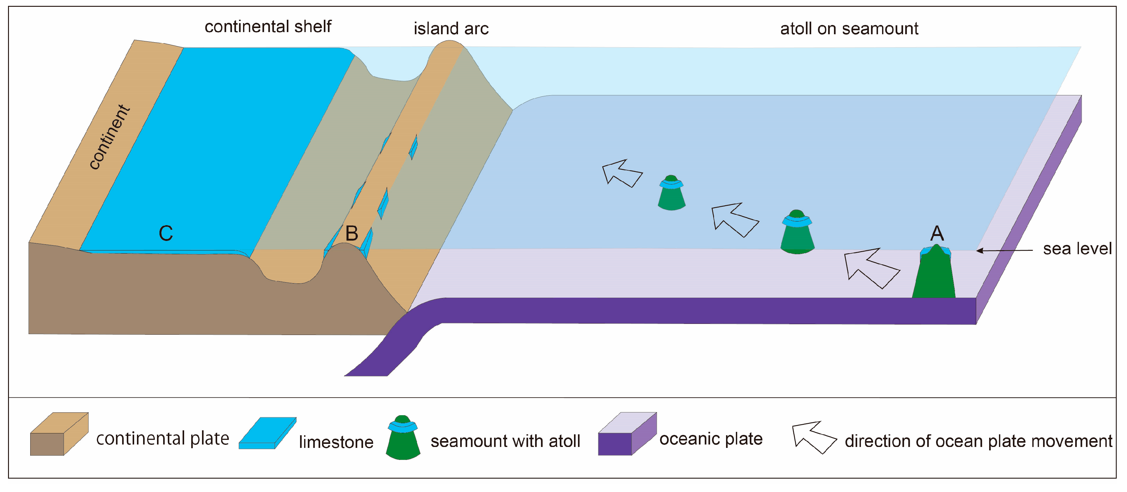
Figure 1. A: Three major depositional environments for limestones. A: Accreted Oceanic Reef (AOR) Limestones deposit atop isolated seamount on the oceanic plate. B: Autochthonous Arc-Shelf (AAS) Limestone are formed along the island arc composed of continental crust. These two types of limestone are recognized in the Japanese Islands. However, most limestones in the world are C: Autochthonous Continental-Shelf (ACS) Limestones, which are formed on the wide continental shelves along the huge continental craton.
Geosciences 15 00393 g001
Figure 2. Distribution of major limestones associated with caves in Japan. Black numbers indicate AOR Limestones, while green numbers show AAS Limestones. The names of limestones and caves are described in Table 1 and Table 2.
Geosciences 15 00393 g002
Figure 3. Formation process of AOR Limestones. The atoll carbonates formed on an isolated seamount of hotspot origin and drifted toward the trench as the oceanic plate moved. They were detached from the seamount and accreted onto the continental margin, becoming part of the new continental crust along with trench-fill sediments and pelagic chert. White arrows indicate the direction of oceanic plate movement.
Geosciences 15 00393 g003
Figure 4. Simplified stratigraphic correlation of AOR Limestones in the Permian accretionary complexes. These stratigraphic columns of the limestones are based on [29,30,31,32,33,34,35,36,37,38,39,40].
Geosciences 15 00393 g004
Figure 6. Simplified stratigraphic correlation of AOR Limestones in the earliest Cretaceous accretionary complexes (after [70,71,72,73,74,75,76,77]).
Geosciences 15 00393 g006
Figure 7. Simplified stratigraphy of formations containing AAS Limestones (after [78,79,80,81,82]).
Geosciences 15 00393 g007
Figure 8. Distribution of Akiyoshi Limestone in the Akiyoshidai Karst Plateau. (a) Location of Akiyoshidai, (b) Distribution of Akiyoshi Limestone. (Ak: Akiyoshido Cave, Ta: Taishodo Cave, Ka: Kagekiyo-ana Cave, Ko: Koto River).
Geosciences 15 00393 g008
Figure 9. View of Akiyoshidai Karst Plateau, where dolines and Karrenfeld are developed. (Photo: 28 May 2022).
Geosciences 15 00393 g009
Figure 10. Overview of Akiyoshido Cave. Gray: Sightseeing area, Black: Non-sightseeing area (vadose caves), Light blue: Non-sightseeing area (phreatic caves).
Geosciences 15 00393 g010
Figure 11. Survey Map of Shushoden branch of Akiyoshido Cave. (Upper: Plan view. Lower: Extended Profile showing 3D structure). P: Photo location for Figure 12.
Geosciences 15 00393 g011
Figure 12. Huge phreatic tube in the Shuhoden Branch of Akiyoshido Cave (Photo: 21 January 2025).
Geosciences 15 00393 g012
Figure 13. Overview of Taishodo-Inugamorino-ana Cave (Plan View). Surveyed: Akiyoshi-dai Karst Speleological Research Group and Speleological Survey Group of Yamaguchi University.
Geosciences 15 00393 g013
Figure 14. Projected profile of Taishodo based on the survey lines and solutional features of the main framework. Red double arrow: Projection direction (N58° W), Red dashed line: General dip trend of the fracture system forming the main framework, I: Paleo-water table (175 m), II: Highest present water table (162 m), III: Lowest present water table (120 m), 1–6: Phreatic solutional features controlled by the fracture system.
Geosciences 15 00393 g014
Figure 15. Overview of Kagekiyo-ana Cave (Plan View). Ka: Main passage of Kagekiyo-ana (black), Mi: Misumata-do (orange), An: Anakuchino-ana (red), Sh: Shishi-no-nukeana (green), CP: Connecting passage (blue), PS: Partially surveyed area (gray), Ent. 1: Kagekiyo Entrance, Ent. 2: Misumata Entrance, Ent. 3: Anakuchi Entrance, Ent. 4: Shishino-nukeana Entrance.
Geosciences 15 00393 g015
Figure 16. Huge phreatic tube in Kagekiyo-ana Cave.
Geosciences 15 00393 g016
Figure 18. Survey Map of Rakan-ana Cave (Plan View). Survey dates: 20–25 September 2022, 22–23 February 2023, 12 January 2025; Total length of survey lines: 768m; Grades: UIS v2 4-4-B and BCRA 5D; Surveyed: Akiyoshi-dai Karst Speleological Research Group and Speleological Survey Group of Yamaguchi University; Cartographers: Takashi MURAKAMI and Mana Nakamura.
Geosciences 15 00393 g018
Figure 19. Location of Anagami Cave, Nakatsu-gawa Tufa, and Kuranuki-Shiraishi Cave (red circles) in Seiyo (Shikoku). Blue Color indicates the distribution of limestone in this area (after [142]). Ohzu, Yawatahama, Seiyo, Unomachi and Kihoku are locality names in this area.
Geosciences 15 00393 g019
Figure 20. Survey Map of Anagami Cave (Plan View). Survey dates: 1–2 September 2018; Total length of survey line: 282.9 m; Altitude difference: 22.6 m; Grades: UIS v2 4-4-B and BCRA 5D; Cartographer: Takashi MURAKAMI; Surveyed: Akiyoshi-dai Karst Speleological Research Group and Speleological Survey Group of Yamaguchi University. Legend is the same as Figure 18.
Geosciences 15 00393 g020
Figure 21. Nakatsu-gawa Tufa. (Photo by Tomohiro Ueno, 27 December 2016).
Geosciences 15 00393 g021
Figure 22. Survey Map of Kuranuki-Shiraishi Cave (Plan View). Survey dates: 18 September 2021, 20 February 2023; Total length of survey lines: 24.2 m; Altitude difference: 7 m+; Grades: UIS v2 5-4-B and BCRA 6D; Surveyed: Takashi Murakami, Yuka Watanabe, Sae Ohkouchi; Cartographer: Takashi Murakami. Legend is the same as Figure 18.
Geosciences 15 00393 g022
Figure 23. (a) Elevation map of the Okinoerabu Island, Kagoshima Prefecture, Japan [160], showing the location of Shoryu-do Cave and Mt. Oyama, and (b) Geological map of the Okinoerabu Island [161]. These map show showing the location of Shoryu-do Cave and Mt. Oyama.
Geosciences 15 00393 g023
Figure 24. Formation model of coral reef—karst complex.
Geosciences 15 00393 g024
Figure 25. Location of the Shoryu-do Cave System. (A): Distribution of caves, springs, and dry valleys. (B): Map of Okinoerabu Island.
Geosciences 15 00393 g025
Figure 26. Plan View and Extended Profile of Hakuho-do Cave (after [169]).
Geosciences 15 00393 g026
Figure 27. Limestone (upper part) and sandstone (lower part) exposed on the cave wall in the upper level of the Hakuho-do Cave. (Photo by Yuki Fujii, 13 August 2025).
Geosciences 15 00393 g027
Figure 28. Clusters of helictites growing over soda straws in the Hall of Hakuho (12 September 2025).
Geosciences 15 00393 g028
Figure 29. Plan View of Ginsui-do Cave. (after [171]).
Geosciences 15 00393 g029
Figure 30. Canyon passage of Ginsui-do Cave. Ceiling: Ryukyu Limestone, Upper cave wall: Speleothems, Lower cave wall: Neori Formation mudstone (Photo by Takechiyo Arikawa, 1 January 2022).
Geosciences 15 00393 g030
Figure 31. Huge flowstone with rimstone pools in Ginsui-do Cave (Photo by Takechiyo Arikawa, 18 August 2025).
Geosciences 15 00393 g031
Figure 33. Formation process of AOR Limestones incorporated into the Jurassic accretionary complex, reconstructed on the oceanic plate. Paleogeographic base maps were created after [174].
Geosciences 15 00393 g033
Figure 34. Formation process of AOR Limestones incorporated into the earliest Cretaceous accretionary complex, reconstructed on the oceanic plate. Paleogeographic base maps were created after [174].
Geosciences 15 00393 g034
Figure 35. Karst landforms and their relationship to limestone origin such as AOR Limestone and AAS Limestone in Japan, and ACS Limestone in most of the world.
Geosciences 15 00393 g035
Table 1. List of major AOR Limestones in Japan.
No.Complex Geologic BeltLimestone Plateau or Mt.PrefectureAgeMajor Caves
1Permian Accretionary ComplexAkiyoshi beltHiraodai LimestoneHiraodaiFukuokaCarboniferous to PermianSenbutsu
2Permian Accretionary ComplexAkiyoshi beltAkiyoshi LimestoneAkiyoshidaiYamaguchiCarboniferous to PermianAkiyoshido, Taishodo, Kagekiyo-ana
3Permian Accretionary ComplexAkiyoshi beltTaisyaku LimestoneTaisyakudaiHiroshimaCarboniferous to PermianHaku-un-do
4Permian Accretionary ComplexAkiyoshi beltKoyama-Nakamura LimestoneOhgadaiOkayamaCarboniferous to PermianIwaya-do
5Permian Accretionary ComplexAkiyoshibeltAtetsu LimestoneAtetsudaiOkayamaCarboniferous to PermianIkura-do, Maki-do
6Permian Accretionary ComplexAkiyoshi beltŌmi LimestoneKurohime-MyojoNiigataCarboniferous to PermianByakuren-do, Ōmi-Senri-do, Fukugakuchi
7Permian Accretionary ComplexKurosegawa beltŌnogahara-Torigatayama LimestoneShikoku KarstEhime-KochiCarboniferous to PermianRakan-ana
8Jurassic Accretionary ComplexTamba beltLimestone of Shizushi Cave KyotoPermianShizushi
9Jurassic Accretionary ComplexMinobeltRyozen LimestonesRyozenzanGifu-MiePermianSekigahara
10Jurassic Accretionary ComplexMino beltIbukiyama LimestoneIbukiyamaGifuPermiannot found
11Jurassic Accretionary ComplexMino beltFunafuseyama LimestoneFunafuseyamaGifuPermiannot found
12Jurassic Accretionary ComplexMino beltAkuda Limestone GifuPermianOtaki, Jomon
13Jurassic Accretionary ComplexMino beltAkasaka LimestoneKinshozanGifuPermiannot found
14Jurassic Accretionary ComplexMino beltLimestone of Hida Great Cave GifuPermianHida Great
15Jurassic Accretionary ComplexAshio beltKuzu-u Limestone TochigiPermianIzuru, Utsuno
16Jurassic Accretionary ComplexAshio beltLimestone of Odaira Cave TochigiPermianOdaira
17Jurassic Accretionary ComplexChichibu beltLimestone of Ryugashi Cave ShizuokaPermianRyugashi-do
18Jurassic Accretionary ComplexChichibu beltLimestone of Ohtake Cave TokyoPermianOhtake
19earlliest Cretaceous Accretionary ComplexSambosan beltLimestone of Konose Group KumamotoPermian to TriassicKyusen-do, Konose
20earlliest Cretaceous Accretionary ComplexSambosan beltKamura Limestone MiyazakiPermian to Triassicnot found
21earlliest Cretaceous Accretionary ComplexSambosan beltTsukumi Limestone OitaPermian to Triassicnot found
22earlliest Cretaceous Accretionary ComplexSambosan beltLimestone of Ryuga CaveSambosanKochiPermian to TriassicRyuga-do
23earlliest Cretaceous Accretionary ComplexSambosan beltLimestone of Yasumori Cave EhimePermian to TriassicYasumori-do
24earlliest Cretaceous Accretionary ComplexSambosan beltLimestone of Totsui Cave WakayamaPermian to TriassicTotsui
25earlliest Cretaceous Accretionary ComplexSambosan beltLimestone of Menfudo Cave NaraPermian to TriassicMenfudo
26earlliest Cretaceous Accretionary ComplexSambosan beltBukozan LimestoneBukozanSaitamaTriassicHashidate
27earlliest Cretaceous Accretionary ComplexNorth Chichibu beltAkka Limestone IwateTriassicRyusen-do, Akka-do
28earlliest Cretaceous Accretionary ComplexNorth Chichibu beltShiriyazaki Limestone AomoriTriassicShiriyazaki
29Cretaceous Accretionary ComplexHidaka beltLimestone of Tohma Formation HokkaidoJurassicTohma
30Oceanic ridge on Philippines Sea PlateSouth Borodino IslandLimestone and dolomeite of Daito Formation OkinawaUpper Miocene-PlioceneHoshino-do
Table 2. List of major AAS Limestones in Japan.
No.Sedimentary EnvironmentStratigraphic NameLithologyAgeGeologic Belt or AreaName of CavesPrefectureCity, Town, Island
31Paleozoic Continental ShelfNagaiwa FormationLimestoneCarboniferousSouth Kitakami beltRokkandoIwateSumita Town
32Paleozoic Continental ShelfKawauchi FormationLimestoneSilurianSouth Kitakami beltSekiyaIwateOfunato City
33Paleozoic Continental ShelfTobigamori GroupLimestoneDevonian to CarboniferousSouth Kitakami beltYugendoIwateIchinoseki City
34Paleozoic Continental ShelfTakine GroupLimestoneOrdovician to DevonianSouth Kitakami beltAbukumaFukushimaTamura City
Takine Town
35Paleozoic Continental ShelfTakine GroupLimestoneOrdovician to DevonianSouth Kitakami beltIrimizuFukushima
36Jurassic Arc ShelfTorinosu LimestoneLimestoneJurassicChichibu beltAnagamiEhimeSeiyo City
37Jurassic Arc ShelfTorinosu LimestoneLimestoneJurassicChichibu beltKuranuki-ShiraishiEhimeSeiyo City
38Cenozoic Arc ShelfKakinoura FormationSandy/Algae LimestoneOligoceneKyushu IslandNanatsugamaNagasakiSaikai City
39Cenozoic Arc ShelfNakatonbetsu FormationFossil Shell LimestonePlioceneHokkaido IslandNakatonbetsuHokkaidoNakatonbetsu Town
40Cenozoic Arc ShelfRyukyu GroupCoral LimestonePleistoceneRyukyu IslandsShoryudoKagoshimaOkinoerabu Island
41Cenozoic Arc ShelfRyukyu GroupReef LimestonePleistoceneRyukyu IslandsAkasakiKagoshimaYoron Island
42Cenozoic Arc ShelfRyukyu GroupClastic LimestonePleistoceneRyukyu IslandsGyokusendoOkinawaOkinawa Main Island
43Cenozoic Arc ShelfRyukyu GroupCoral LimestonePleistoceneRyukyu IslandsIshigakijimaOkinawaIshigaki Island
Table 3. Comparison of Karst Features in Three Regions.
Region
(Limestone)
Limestone TypeLithologyFracture SystemKarst FeaturesCave FeaturesGroundwater System
Akiyoshidai
(Akiyoshi Limestone)
AORMassive, non-bedded, high-purity3-dimensional fracture systemDoline karst on plateau, fluvial karst plains at the foot of margins3-dimensional caves controlled by fracture system, originating from bathyphreatic cavesExtensive groundwater network, conduits formed by phreatic caves
Seiyo (Shikoku)
(Torinosu Limestone)
AASSmall lens-shaped bodies within sandstone and mudstone strata3-dimensional fracture systemMany swallow holes and karst springs in mountains3-dimensional caves controlled by fractures and geological boundariesSmall groundwater systems confined to individual limestone bodies
Okinoerabu Island
(Ryukyu Limestone)
AASWell-bedded with interbedded terrestrial clastic layersAlmost absentNumerous dolines and karst dry valleys on emergent coral-reef limestonePlanar Subterranean river cave systems developed along geological boundariesRadially developed along island slopes; some connect to the sea via submarine caves
Disclaimer/Publisher’s Note: The statements, opinions and data contained in all publications are solely those of the individual author(s) and contributor(s) and not of MDPI and/or the editor(s). MDPI and/or the editor(s) disclaim responsibility for any injury to people or property resulting from any ideas, methods, instructions or products referred to in the content.