Article

New Porphyry Copper–Molybdenum Ore Occurrence in Arganaty Granites of the Eastern Balkhash (Kazakhstan): Geology, Geochemistry, and Mineralogy

1
Department of Geological Survey, Search and Exploration of Mineral Deposits, Geology and Oil-Gas Business Institute Named after K. Turyssov, Satbayev University, 22 Satbaev Str., Almaty 050013, Kazakhstan
2
Institute of Geology of Ore Deposits, Petrography, Mineralogy and Geochemistry, Russian Academy of Sciences (IGEM RAS), Staromonetny Per. 35, 119017 Moscow, Russia
*
Author to whom correspondence should be addressed.
Geosciences 2024, 14(9), 237; https://doi.org/10.3390/geosciences14090237
Submission received: 7 August 2024 / Revised: 29 August 2024 / Accepted: 29 August 2024 / Published: 2 September 2024

Abstract

:
In the Balkhash region of Kazakhstan, there are numerous copper and copper–molybdenum deposits, including superlarge Aktogay, Aidarly, Kounrad, and large Sayak deposits. Despite the proximity to these ore districts, the Arganaty district of the Eastern Balkhash region has not attracted significant interest in terms of exploration for many years. Our recent work has identified previously undetected copper–molybdenum mineralization in the granites of the Arganaty massif and has provided a new perspective on the economic potential of this area. In this study, based on the geology, mineralogy, and geochemistry of the Arganaty granites using data from XRF and ICP-MS methods, we reassessed the geological structure and prospectivity of this area. Our investigations have found that the intrusive rocks of the Arganaty massif belong to I-type granites and were formed in a subduction setting rather than a collision setting, as was previously believed. This also indicates the high prospects of the territory in the context of the possible discovery of large Cu or Cu–Mo deposits.

1. Introduction

The Balkhash metallogenic belt is located in the west of the Central Asian Orogenic Belt (CAOB) and hosts many metallic deposits (Au, Cu, Mo, Pb-Zn) [1,2,3]. Numerous studies have been dedicated to the geology of this region [4,5,6,7,8,9,10,11], as well as to mineral deposits [12,13,14,15,16,17,18,19], including well-known ones like Aktogay [20], Aidarly [2], Kounrad [21], Sayak [21], Zhanet [22], and Akshatau [22].
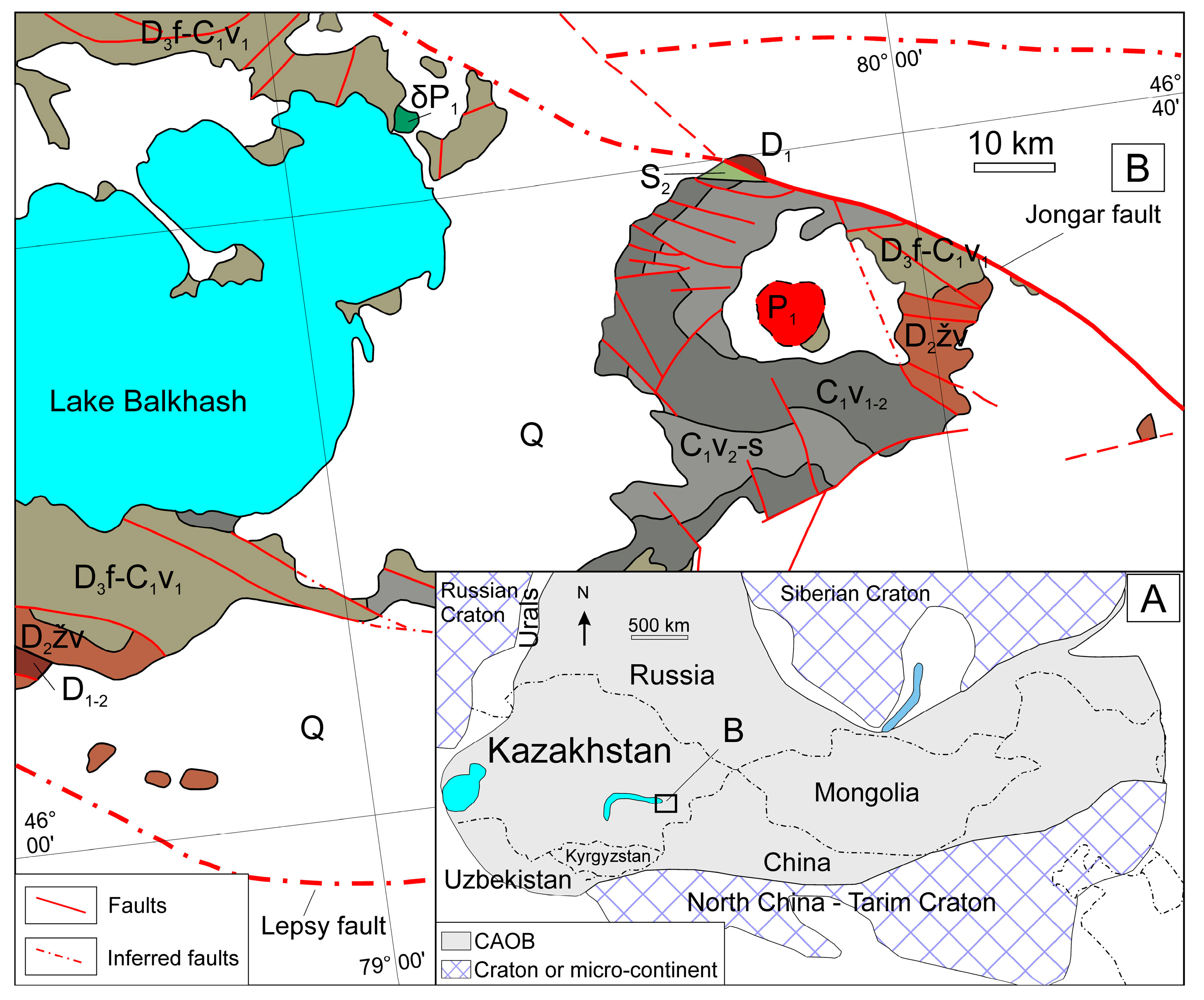
The Arganaty region is located in the East Balkhash metallogenic belt between Lake Balkhash and Lake Alakol [23,24]. The region borders the Aktogay district (home to the Aktogay and Aidarly deposits) to the north, while Lake Balkhash lies to the west (Figure 1 and Figure 2). To the east and south, numerous gold and tungsten deposits and occurrences have been identified in the Zhetysu (Junggar) Alatau ranges. Despite their proximity to ore districts, the Arganaty and Arkarly mountain regions have not attracted significant exploration interest for many years. Geological surveys at scales of 1:50,000 and 1:200,000 in the 1960s, 1970s, and 2000s identified numerous ore occurrences and mineralization points for gold, iron, and other metals, most of which were deemed to have limited prospectivity. Some regional studies have addressed this area, such as those examining the cosmogenic nature of ring structures [23,25]. Some research considers the region an astrobleme—resulting from a Permian–Triassic meteorite impact [23,26,27,28], where arcuate mountain chains were interpreted as a ringed rim of impact ejecta.
Recent studies [24,29,30,31] have identified previously undetected industrial-grade copper–molybdenum mineralization in the granites of the Arganaty massif, providing a new perspective on the potential of this area. In this work, based on the geology, mineralogy, and geochemistry of the Arganaty granites, we aim to reassess the geological structure and evaluate the ore-bearing prospects of this region.
Figure 1. The Arganaty region on the geological map of Kazakhstan at a scale of 1:1,000,000 [32].
Geosciences 14 00237 g001
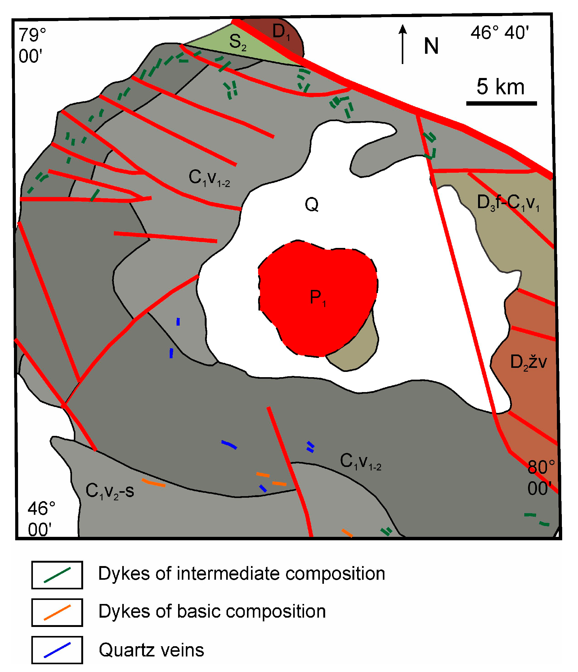
Figure 2. Geological map of the Arganaty region. For other symbols, refer to Figure 1.
Geosciences 14 00237 g002

2. Physical and Geographical Characteristics of the Region

The Arganaty region is situated in the Jetysu area. It is characterized by a depression surrounded by a chain of low mountains, including the Arganaty and Arkarly ranges, which form a closed ring (Figure 3). The absolute elevations of the depression range from 400 to 450 m, while the highest peaks of the surrounding mountains reach 700 to 750 m. The northern slopes of the Arganaty mountains are steep and sharply dissected by a dense network of ravines. These slopes are separated from the adjacent northern plain by a tectonic escarpment with a height of 100 to 150 m.

3. Materials and Methods

The geological structure of the Arganaty region has been investigated through field geological surveys and the interpretation of satellite imagery. The granites of Arganaty were studied based on well documentation from mapping and exploratory drillings, followed by further laboratory analyses. The interpretation of satellite images and field surveys refined the structure and geology of the area. Well samples were collected for petrographic and mineralogical analyses, as well as for X-ray fluorescence (XRF) and inductively coupled plasma mass spectrometry (ICP-MS) methods to determine the composition of major oxides and trace elements.
The geological structure of the Arganaty region was refined using satellite image interpretation. Remote sensing data included archived Landsat ETM+ and ASTER imagery, as well as digital elevation models from SRTM (2000) and ASTER GDEM (2011). Landsat ETM+ imagery has a spatial resolution of 30 m for channels 1, 2, 3, 4, 5, and 7, 60 m for channel 6, and 14.25 m for the PAN channel. Two Landsat scenes were used: p147r028_7dk19990826 and p148r028_7dk19990817. The SRTM data, with a spatial resolution of 90 m, provides a digital elevation model. ASTER data includes VNIR imagery with 15 m spatial resolution (bands 1: 520–600 nm, 2: 630–690 nm, 3: 760–860 nm), SWIR imagery with 30 m spatial resolution (bands 4: 1600–1700 nm, 5: 2145–2185 nm, 6: 2185–2225 nm, 7: 2235–2285 nm, 8: 2295–2365 nm, and 9: 2360–2430 nm), and TIR imagery with 90 m spatial resolution (bands 10: 8125–8475 nm, 11: 8475–8825 nm, 12: 8925–9275 nm, 13: 10,250–10,950 nm, and 14: 10950–11,650 nm). The ASTER GDEM provides a digital elevation model with a spatial resolution of 25 m.
Mineralogical and petrographic studies were conducted using an Axis Scope A1 microscope equipped with a digital camera.
The concentration of major oxides and some trace elements in the samples were determined at IGEM RAS, Moscow, Russia, using X-ray fluorescence (XRF) analysis (analyst A.I. Yakushev). The analysis was performed on a vacuum sequential X-ray spectrometer (wavelength dispersive), model Axios mAX, produced by PANalytical (Almelo, The Netherlands). The spectrometer is equipped with a 4 kW X-ray tube with an Rh anode. The maximum tube voltage is 60 kV, and the maximum anode current is 160 mA. Calibration of the spectrometer utilized industry and government standard samples for rock chemical composition.
The determination of trace elements was carried out at the Institute of Microelectronics Technology and High Purity Materials RAS in Chernogolovka, Moscow Region, Russia (analyst V.K. Karandashev). For mass spectrometric analysis, a quadrupole mass spectrometer X-7 (Thermo Scientific, Waltham, MA, USA) was used with the following operating parameters: generator output power of 1300 W; standard nickel cones; a concentric PolyCon nebulizer; a quartz conical spray chamber cooled to 3 °C; an argon plasma flow rate of 13 L/min; an auxiliary argon flow rate of 0.9 L/min; an argon flow rate in the nebulizer of 0.95 L/min; and a sample consumption rate of 0.8 mL/min. Sample digestion was carried out in an autoclave. The samples were placed in teflon reaction vessels of the autoclaves and dissolved by heating with HNO3 and HClO4. Then, deionized water was added to the solution, and an internal standard (10 µg/L of indium) was introduced.

4. Geology

The strata in the Balkhash region are divided into three units: Precambrian metamorphic basement, Paleozoic folded sedimentary and metamorphic rocks, and Mesozoic and Cenozoic sandstone and mudstone [3]. Most of the Arganaty region and its surrounding areas are covered by Quaternary deposits. Paleozoic deposits are well exposed in the region, while Precambrian formations are found outside the area. The region is situated between two regional faults: the Lepsy and Jongar faults (Figure 1). The faulting in the Arganaty area has predominantly northwest and sub-latitudinal trends. This zone is located in the northeastern part of the Jongar Alatau and extends to the northeastern shore of Lake Balkhash for over 400 km, with a maximum width of 125 km. From the Ordovician to the Middle Carboniferous, continuous sedimentation occurred in the region, resulting in a complete stratigraphic sequence and significant sediment thickness (up to 15 km). Deposits of jasper–basalt and green-colored terrigenous–siliceous–basaltic formations accumulated in an oceanic basin. Starting from the Late Devonian, subduction of the Jongar–Balkhash Ocean occurred [31,33,34], which ended with the formation of a collision zone [14,33,35,36,37].
Most of the Arganaty mountain region is composed of Devonian and Carboniferous deposits that form the mountain ranges. Permian granites of the Arganaty massif are obscured by Paleogene and Quaternary deposits. Silurian formations, which are limited in distribution, are found in the northern part of the region. Outside the Arganaty and Arkarly mountains, Paleozoic formations are covered by Cenozoic deposits [4,38].
The Upper Silurian (S2) is represented by gray sandstones, tuffaceous sandstones, and siltstones with layers of conglomerates, gravels, and sandy limestones [4]. The Lower and middle Devonian (D1) deposits include sandstones, tuffaceous siltstones, and tuffites. Deposits near the Devonian–Carboniferous boundary (Frasnian–Visean) are developed in the eastern part of the area and characterized by tuffaceous siltstones, tuffites, and argillites. The Lower Carboniferous are represented by conglomerates, gravels, sandstones, tuffaceous siltstones, tuffites, carbonaceous argillites, clayey–siliceous rocks, and manganiferous siliceous rocks.
Exposures of intrusive rocks at the surface are almost absent, except for dykes (Figure 2) with intermediate and basic compositions, less frequently acidic ones, as well as numerous quartz veins. These surface exposures are mostly observed in the southern part of the region. Dykes typically form morphologically regular tabular bodies with thicknesses ranging from a few meters to 10–15 m and lengths extending over several dozen or, less frequently, hundreds of meters. Within the region, most dykes have undergone intense hydrothermal alteration, manifested as quartzization, sericitization, chloritization, epidotization, and carbonation.
The Arganaty granite massif is identified only through geophysical surveys and drill wells at depths of 10–70 m beneath a cover of loose sediments. The massif occupies the central part of the region and, according to magnetometric data, has an oval or circular shape, covering an area of approximately 100–120 km2.

4.1. Decoding of Satellite Images

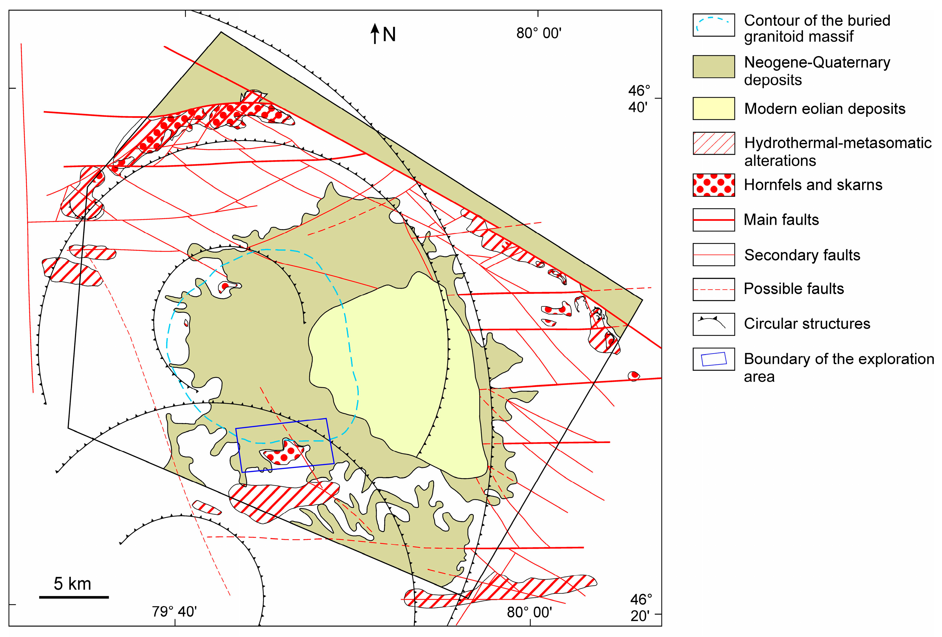
As a result of the satellite image decoding work, we have developed a structural map of the Arganaty area (Figure 4).
In the area, linear, circular, and areal structures have been identified. The faulting in the Arganaty area predominantly trends northwest and sub-latitudinal. The main fault is a right-lateral displacement located at the northeastern boundary of the area. Secondary faults include sub-latitudinal fractures associated with the main structure. The amplitudes of right-lateral displacements in such structures reach up to 860 m. Other faulting features predominantly trend northeast.
In the Arganaty area and its immediate vicinity, ring structures with diameters ranging from 0.25 to 95 km have been decoded. It should be noted that the area is located in the central part of a second-order magmatogenic telescopic ring structure with a diameter of 95 km. Within this ring structure, there are smaller ring structures “nested” inside. The presence of such a complex of ring structures typically indicates a multi-tiered position of intermediate magmatic centers [38,39,40]. The system of telescoped ring structures not only points to the location of a prolonged endogenous activity focus, likely magmatic, but may also provide insights into its formation conditions and stratigraphy. Based on possible formation mechanisms, all ring structure areas are conditionally divided into magmatogenic and hydrothermal–metasomatic types.
In the region, areas with evidence of thermal and hydrothermal–metasomatic alterations in the host rocks have been identified. Hornfels are found in the northern and eastern parts of the area. Spectral analysis of Aster data for areas with hydrothermal–metasomatic changes indicates the presence of newly formed minerals such as muscovite, chlorite, carbonate, and epidote. All these areas of hydrothermally altered rocks tend to be associated with faulting features oriented northwest and sub-latitudinally.

4.2. Arganaty Massif

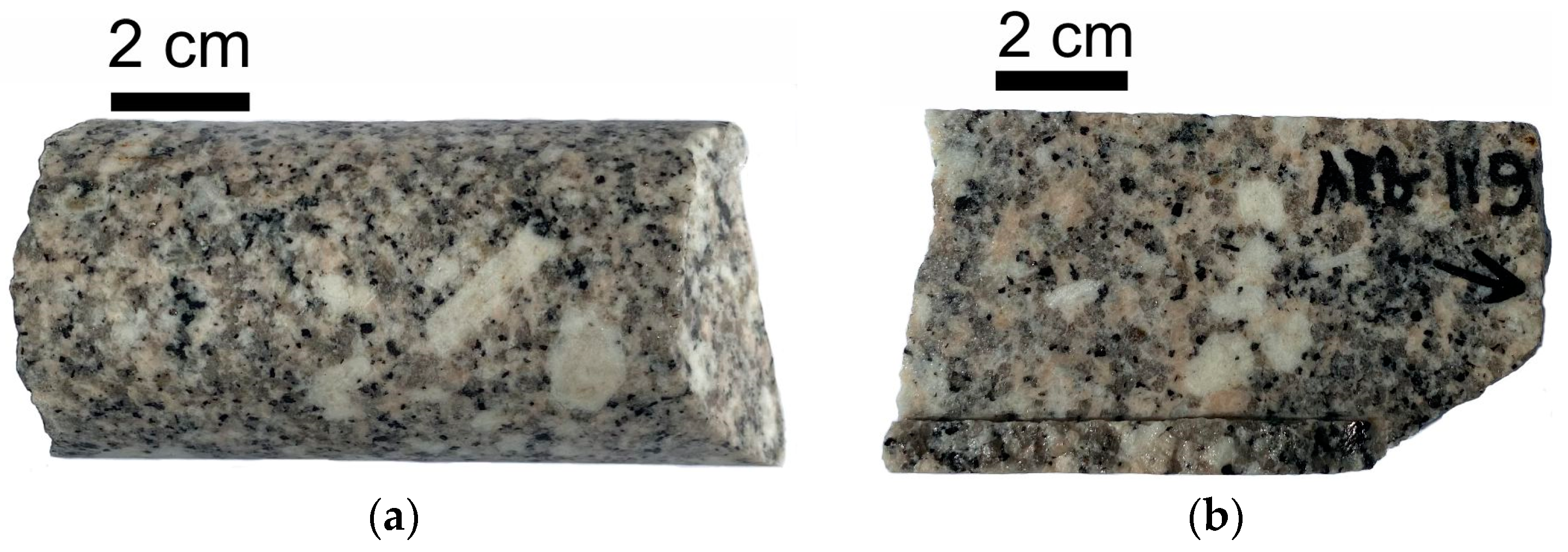
The granites of the Arganaty massif are represented by fine-to-medium-grained porphyritic biotite granites, which are characterized by a pinkish-gray, or less commonly a greenish-gray, color due to chloritization.
The Arganaty massif has been classified by some researchers as part of the Lepsy intrusive complex [23], while others have assigned it to the Katbar intrusive complex [7,41,42]. The Lepsy complex includes large granite plutons of Northern Jungaria (Lepsy, Pokatilov, Arasan, and others), which belong to the adamellite–granite formation [4,43]. The Katbar complex includes late Carboniferous–Permian granitic massifs in the Sayak area of Northern Balkhash, such as the Katbar, Besoba, and others [4,42,43]. The Lepsy and Katbar complexes are considered analogs [4]. Isotopic age analysis using the potassium–argon method has established the Permian age of the Arganaty massif granites at 252–273 million years [43].

5. Results

5.1. Petrography of the Arganaty Granites

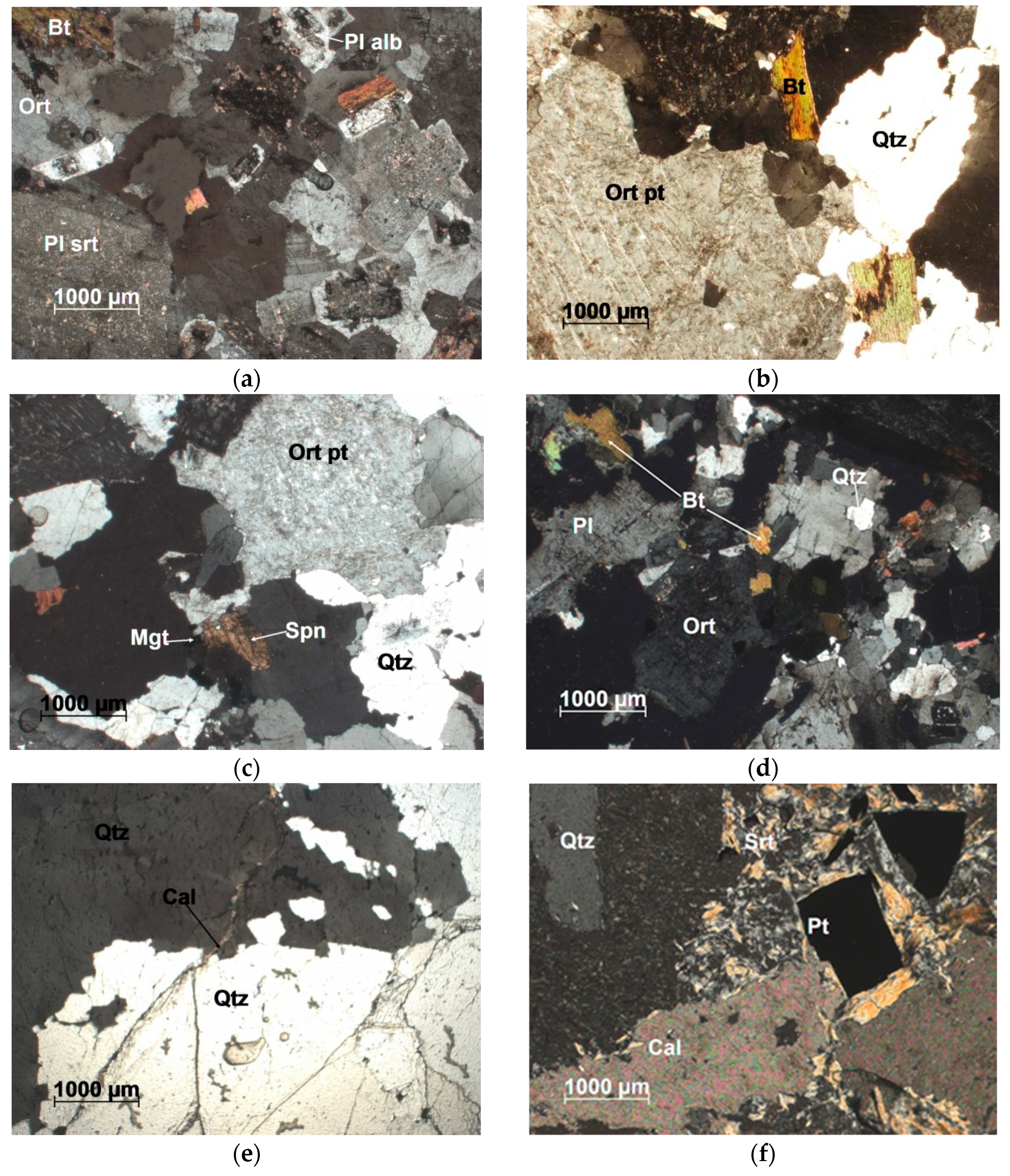
Microscopic examination of the granites shows that their main mass has a hypidiomorphic–granular, granite, and glomeroporphyritic structure, with a massive texture (Figure 5). Glomeroporphyritic aggregates are represented by clustered accumulations of plagioclase and, less commonly, orthoclase, ranging from 5–15 mm and often up to 3.5–4.0 cm, as seen in Figure 6. Biotite flakes, rarely up to 1 cm, form phenocrysts. The granites consist of potassium feldspar (40–50%), quartz (up to 30–40%), plagioclase (up to 20–30%), biotite (up to 5%), and accessory minerals (sphene, zircon, and ore minerals up to 5%).
Among the minerals listed above, biotite and plagioclase exhibit the highest degree of idiomorphism. Plagioclase forms individuals of short-prismatic and tabular shapes up to 2.5 mm in size (Figure 6). It is twinned, with both simple and polysynthetic twins. Occasionally, antiperthites are observed. The growth shapes of plagioclase vary and are irregular, with short-tabular forms. Optically, plagioclase corresponds to albite–oligoclase. As inclusions within plagioclase, rare biotite flakes and rare apatite crystals (0.1 mm) are found. Locally, plagioclase is replaced by potassium feldspar and quartz. Quartz forms rounded and irregularly shaped grains, usually no larger than 1–3 mm, as well as aggregates of unevenly distributed grains.
Potassium feldspar is xenomorphic relative to other minerals in the rock and forms irregular and short-tabular grains, often showing pelitic texture. The structure of individual grains is usually microperthitic.
Biotite occurs as rare scales that are idiomorphic relative to other minerals in the rock. The scales are short-tabular and irregular in shape. The color of the mineral ranges from greenish-brown (Ng) to pale yellowish (Ng). Zircon and apatite (up to 0.1 mm) are found as inclusions within the biotite.
Ore minerals are found as rare grains and are limonitized. Accessory minerals frequently include wedge-shaped sphene, and more rarely prismatic and oddly shaped sphene, which is leucoxenized to varying degrees. Contacts and inclusions in slightly chloritized biotite are common, often associated with magnetite, and in rare cases with apatite and zircon. Isolated aggregates of epidote, developed along plagioclase, are also noted.

5.2. Geochemistry

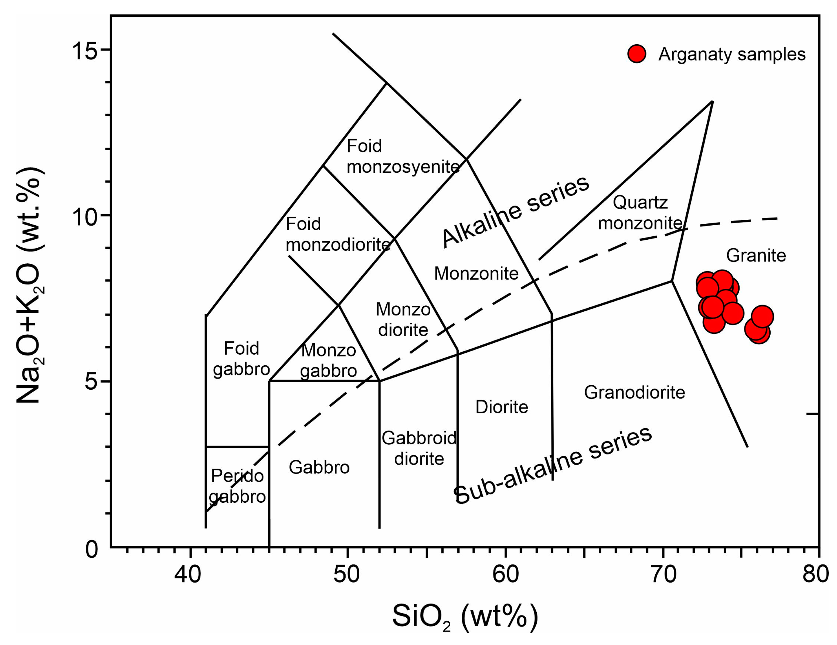
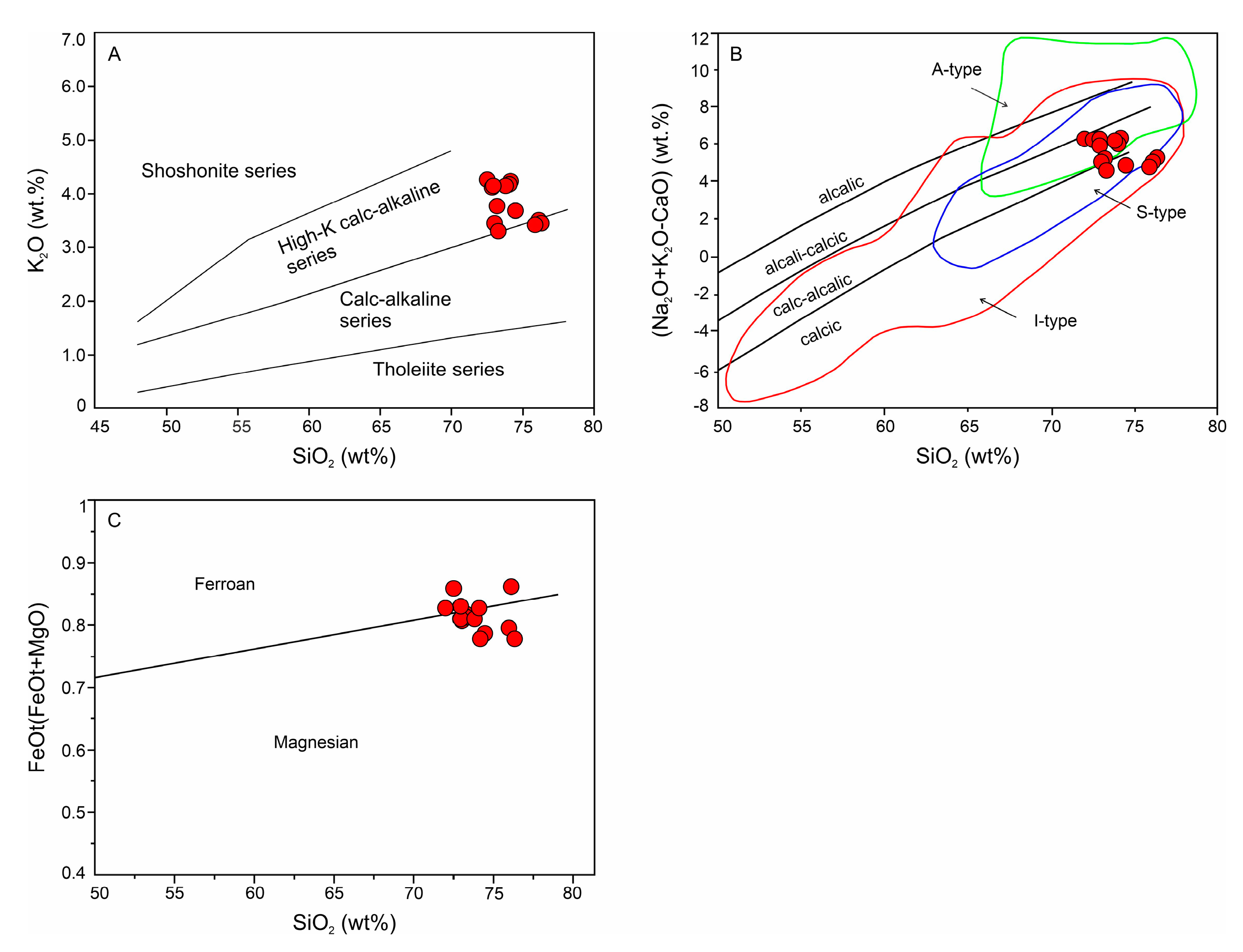
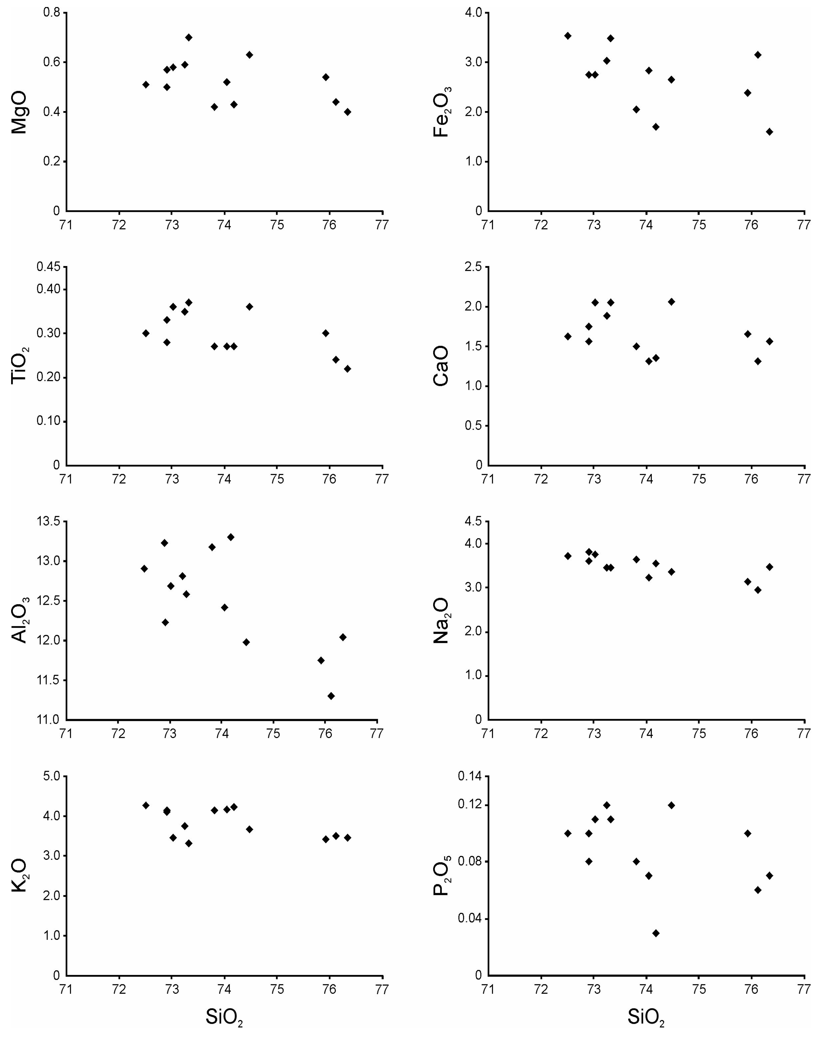
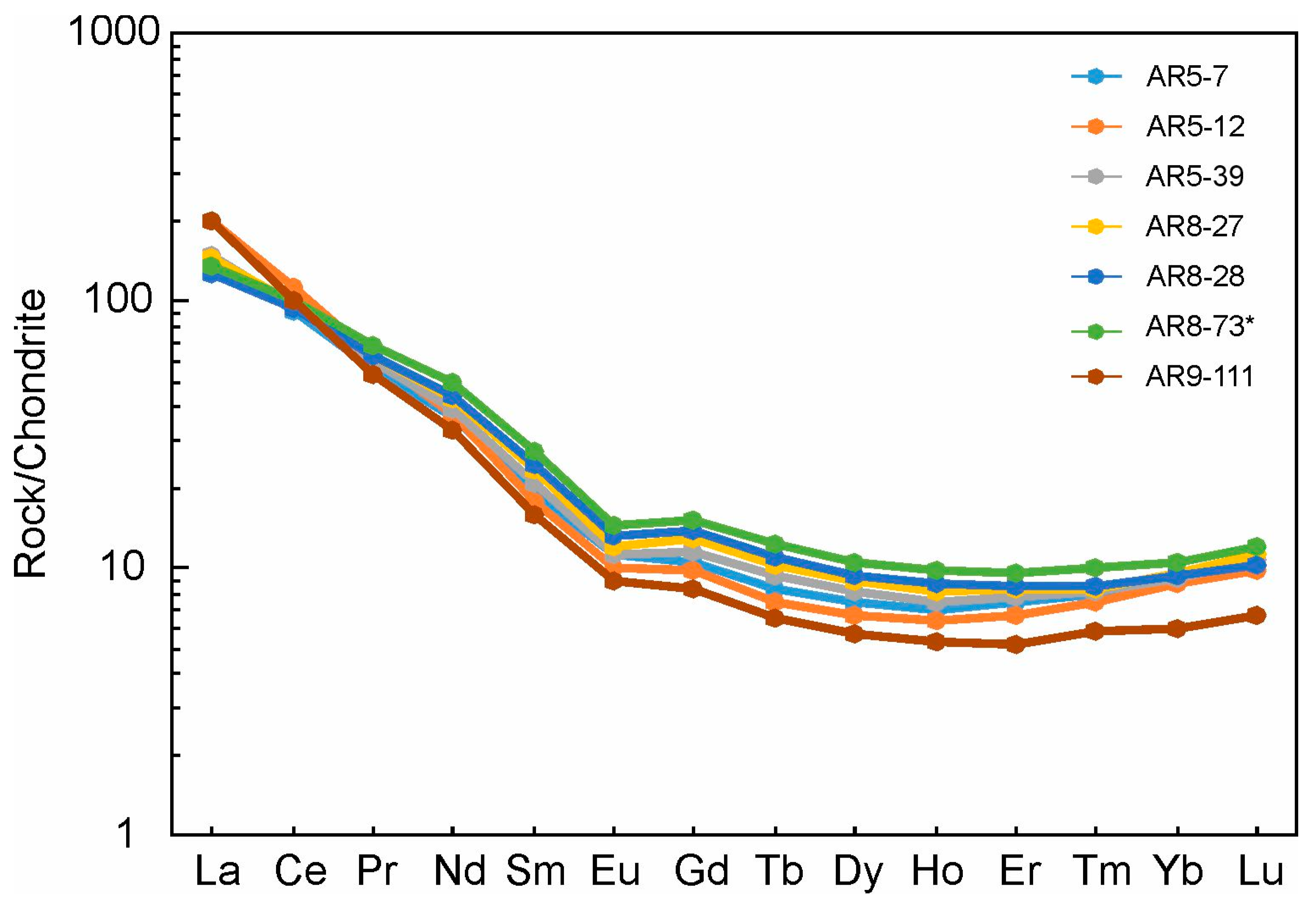
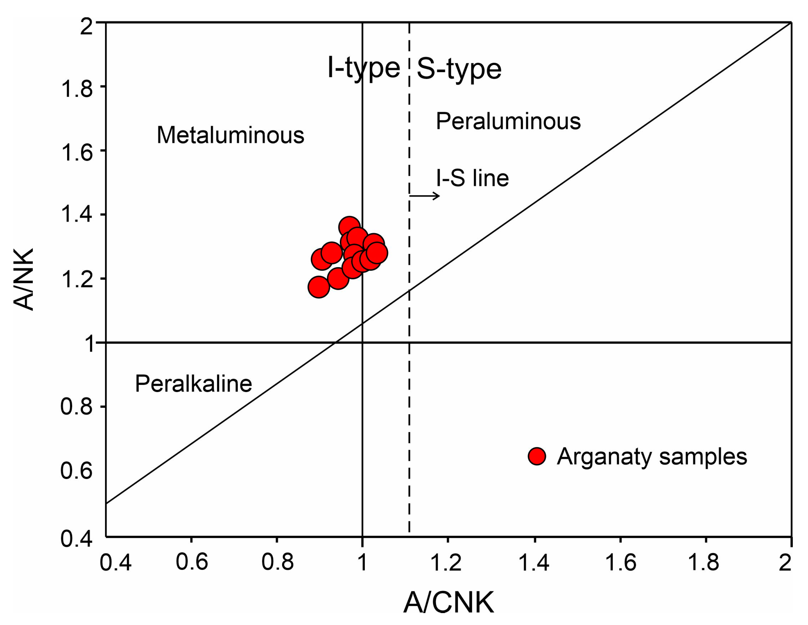
The composition of major oxides and the elemental composition of granites from the Arganaty site are presented in Table 1. Loss on ignition for the rocks of the Arganaty massif ranges from 0.30 to 1.41 wt.%. All samples are characterized by high silica content. The SiO2 contents have relatively small variations between 72 and 76%, and on the SiO2 vs. Na2O + K2O diagram, they correspond to the granite field (Figure 7). As seen in Figure 8, the rocks are metaluminous. The K2O content (3.31–4.30%) and the A.R. index (2.72–4.08) vary, with all samples falling into the high-potassium, calc-alkaline or alkali-calcic rock zone (Figure 9). The rocks of Arganaty are characterized by moderate total alkali content (6.9–7.9%), mainly with similar concentrations of potassium and sodium (K2O/Na2O = 0.92–1.29, average 1.1), and low calcium content (CaO = 1.31–2.08%). The granites of the Arganaty massif are characterized by low magnesia content (0.22–0.33%) (Figure 9). In general, the samples are characterized by low phosphorus content (P2O5 = 0.03–0.12%) and moderate titanium content (TiO2 = 0.22–0.41) (Figure 10 and Figure 11). Chondrite-normalized [44] REE contents show that compared to chondrite, the rocks are enriched in LREE and depleted in HREE (Figure 12). A pronounced Eu anomaly is absent. On the multi-element spider diagram (Figure 13), normalized to the composition of the primitive mantle [44], all samples show positive anomalies for Rb, K, and Pb, and negative anomalies for Ba, Nb, and Ta.
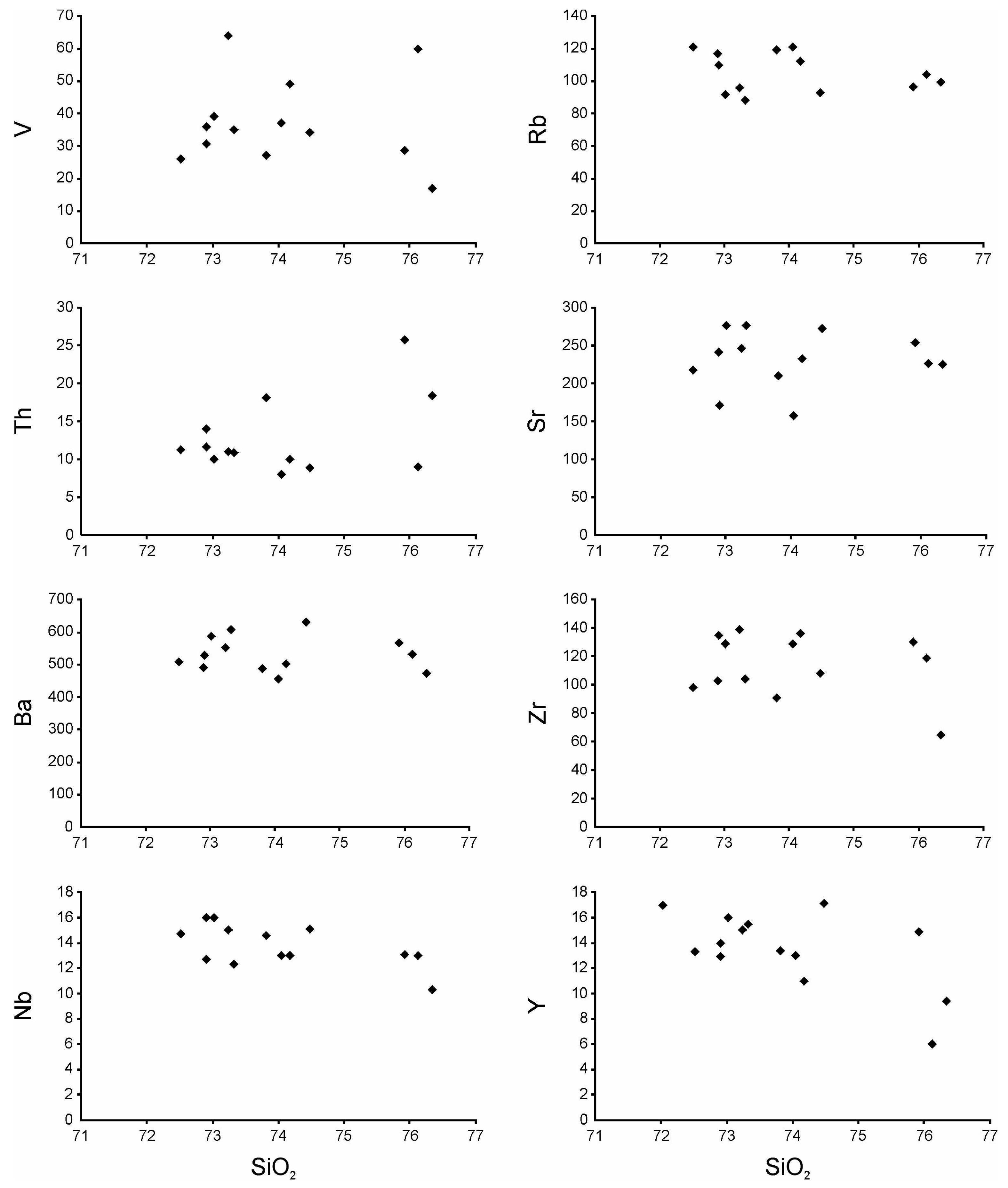
On the Harker binary diagrams, a negative correlation of SiO2 with Al2O3, TiO2, K2O, and CaO is observed (Figure 10 and Figure 11). A positive correlation of MgO with TiO2 and Fe2O3 is also noted. The samples are characterized by low contents of mafic elements: Cr (10–37 ppm) and Ni (5–15 ppm), elevated Rb (88–121 ppm), and a low Sr/Y ratio of 15.9–24.
The granites are characterized by low concentrations of rare earth elements (∑REE = 126–152, with an average of 136.4 ppm) and moderate fractionation [(La/Sm)Nn = 4.9–11.5]. The samples are characterized by a positive correlation of REE contents (except for La) with increasing depth (Figure 12). An exception is the sample from the greatest depth, AR9-111, which has the lowest REE content (except for La). Additionally, the sample AR5-12 stands out with the highest La content. The pattern of increasing with depth is not as distinct for other elements (Figure 13).

5.3. Mineralogy

Ore mineralization associated with quartz veins and stringers was observed in drill holes down to the specified drilling depths (up to 232 m). In exocontacts with the stringers, metasomatic changes (quartzization, sericitization) are noted.
Chalcopyrite, the main copper mineral, is present as rare small inclusions in the quartz mass, reaching up to 2 vol.% where the rock is intensely quartzized. Chalcopyrite forms rare individual grains (ranging from 0.01–0.1 × 0.3 mm to 0.5 × 0.7 mm) in the quartz mass, and small clusters of grains (0.01–0.025 × 0.07 mm). It develops along quartz fractures and is sometimes associated with pyrite, occasionally found in voids (Figure 14a). Large chalcopyrite grains in the quartz mass, measuring 0.2 × 0.6 mm, are rare, and smaller chalcopyrite inclusions (0.01–0.1 mm) are usually observed around them; chalcopyrite grains of 0.01–0.03 mm are found in association with pyrite and titanomagnetite (Figure 14b). Additionally, small rare chalcopyrite inclusions (0.01 mm) occur at the edge of large pyrite aggregates (0.5 × 3 mm). Chalcopyrite is also found as small inclusions (0.01–0.1 × 0.25 mm) within pyrite aggregates and in individual pyrite grains (Figure 14c).
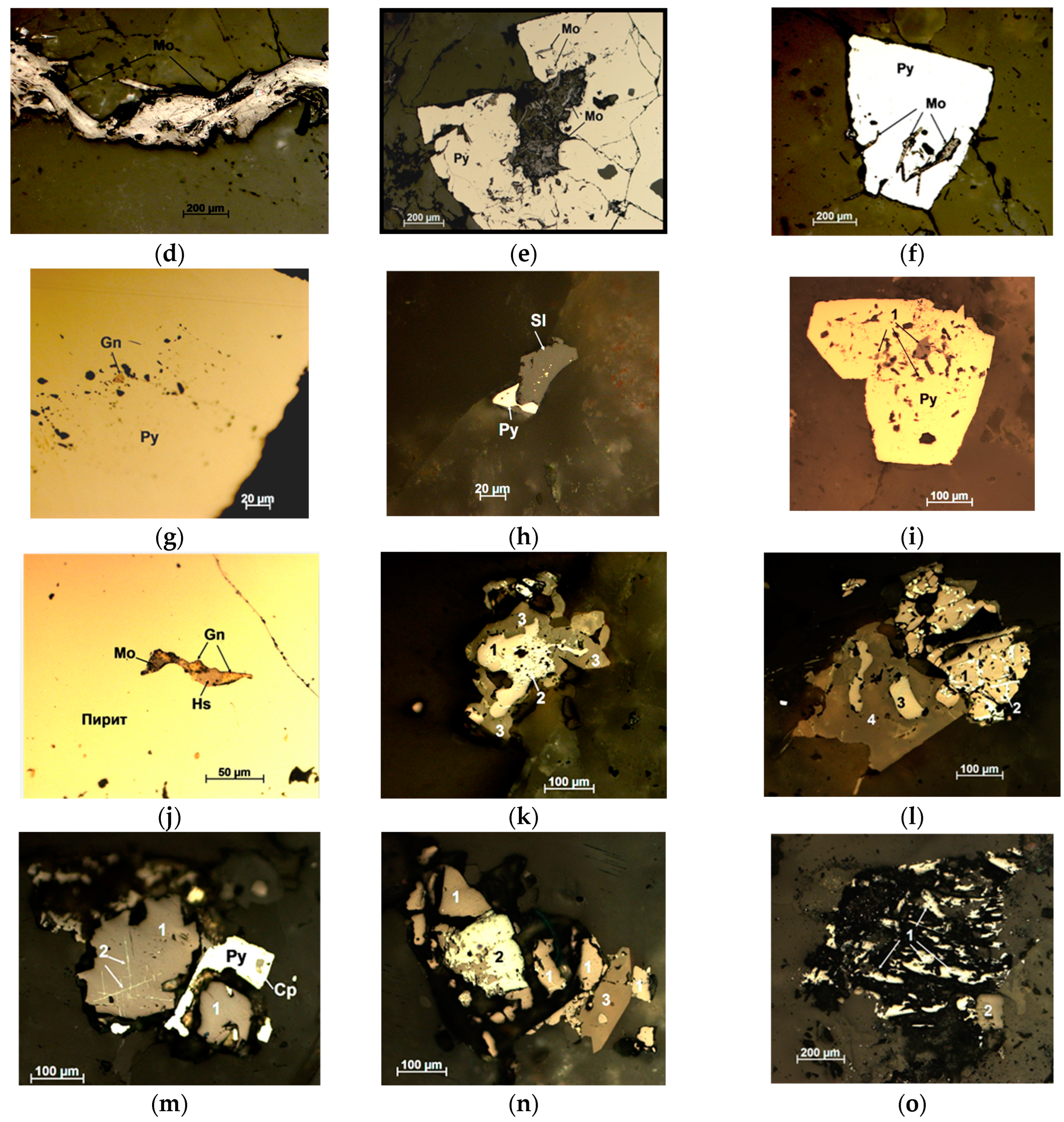
Molybdenum mineralization (molybdenite up to 4 vol.%) is associated with late-stage quartz veins and is superimposed on quartzized and variably metasomatized light-colored porphyritic granites. Molybdenite develops along quartz fractures as elongated (up to 1 cm) discontinuous aggregates and, less commonly, as isolated plate-like inclusions (0.01 × 0.06 mm to 0.2 × 1.7 mm), as well as clusters of individual plate-like grains and their aggregates, located in porous areas (0.005 × 0.02 mm to 0.02 × 0.2 mm, with aggregates up to 0.36 × 0.8 mm), sometimes associated with pyrite (Figure 14d). Along with quartz, molybdenite penetrates into pyrite aggregates, corroding it, and is noted along the edges of its grains (Figure 14e,f).
Pyrite (up to 6 vol.%) occurs in quartz as unevenly distributed grains and grain aggregates. The grain sizes range from 0.01–0.1 × 0.15 mm to 15 × 0.4 mm. In larger grains, quartz and molybdenite inclusions are observed. Pyrite grains are partially corroded by quartz, and replacement of pyrite grains by arsenopyrite is noted. Pyrite is also found in association with titanium minerals and as small inclusions in titanite.
Galena is found as rare small inclusions (0.005–0.01 mm up to 0.01–0.02 × 0.07 mm) within pyrite grains (see Figure 14g).
Sphalerite is found in close association with small pyrite grains (pyrite—0.01 mm and sphalerite—0.25 mm) (see Figure 14h) and occurs as small inclusions (0.01–0.025 × 0.05 mm) in pyrite grains (see Figure 14i), chalcopyrite, and quartz.
Hessite—a silver telluride (Ag2Te)—was found in one instance as a small inclusion in pyrite, closely associated with galena and molybdenite (hessite and galena—0.01 mm and molybdenite—0.01 × 0.035 mm) (see Figure 14j); in another case, it was found in close association with chalcopyrite as small inclusions in a pyrite aggregate. Hessite grains range from 0.01 to 0.03 × 0.1 mm (7–8 grains). The presence of hessite suggests a possible manifestation of a late gold–telluride association.
Titanium minerals, primarily titanomagnetite and titanite (sphene), are quite widespread (see Figure 14k–o), with their quantity reaching up to 3 vol.%.
Titanomagnetite occurs as uneven, rare inclusions (0.05 mm) in quartz and its aggregates (0.25 × 0.5 mm to 0.35–0.7 × 1.5 mm). It may be found with titanite (0.03–0.2 × 0.7 mm) as inclusions in quartz and in aggregates with titanite, and is noted as inclusions (0.05 mm) in larger titanite grains. Titanomagnetite aggregates may replace ilmenite.
Titanite (sphene) is widespread in the form of grain and aggregate inclusions (0.05 × 0.07 mm to 0.2 × 0.7 mm), sometimes with well-defined wedge shapes (0.2 × 0.4 mm) within the quartz mass. There are occurrences associated with small pores, which may be individual grains or aggregates. Titanite can develop along the edges of titanomagnetite. In fairly large titanite aggregates (up to 1 mm) with titanomagnetite (0.2 × 0.35 mm), and within the titanite itself, small inclusions of titanomagnetite (0.05 × 0.15 mm), pyrite (0.01–0.05 × 0.1 mm), and pyrite associated with chalcopyrite (0.01 × 0.02 mm) can be observed. Additionally, some small titanite grains contain minor relic inclusions of titanomagnetite. Titanite can be found in association with ilmenite (with ilmenite breakdown structure in titanomagnetite) or magnetite, which is in turn replaced by hematite. There is close intergrowth of titanium minerals (titanomagnetite and titanite), magnetite, and hematite. Magnetite and titanite are also found as rare inclusions in the quartzized rock mass. Sometimes, titanite, magnetite, and pyrite grains can be observed developing along plagioclase.
Ilmenite is rare compared to titanomagnetite and titanite and is represented by the breakdown structure of plate-like grains within titanomagnetite (0.15 × 0.2 mm).
Rutile is a rare, scattered fine inclusion (0.01–0.03 mm) within quartz. Rutile, which has replaced ilmenite, is often associated with voids. These are aggregates (0.7 mm) of ilmenite grains being replaced by rutile (grains from 0.01 mm to 0.1 × 0.15 mm), and sometimes titanite grains are noted along the edges. Often, only needle-like rutile inclusions are observed within the quartz mass (Figure 14o).
Magnetite is an extremely rare inclusion (up to 0.07 × 0.1 mm) within quartz, as well as aggregates of magnetite grains (up to 0.35 × 0.7 mm) with hematite inclusions, with titanite developing along the edges. Magnetite and titanite are also found as separate inclusions within the quartzized rock.
Zircon is present as rare small grains (0.01 × 0.02 and 0.025 × 0.035 mm, up to 0.05 × 0.07 mm) in quartz and titanite, as well as in association with titanomagnetite and titanite.
Bornite occurs as isolated grains (up to 0.02 × 0.06 mm) within quartz.
Arsenopyrite replaces pyrite in aggregate pyrite occurrences, with replacement areas reaching up to 0.05 × 0.25 mm.

6. Discussion

As shown in the A/CNK and A/NK ratio diagrams (Figure 8), most samples from the Arganaty massif fall into the meta-aluminous granite category, while a small portion is on the boundary between the meta-aluminous and peraluminous groups. The A/CNK index varies between 0.9 and 1.03.
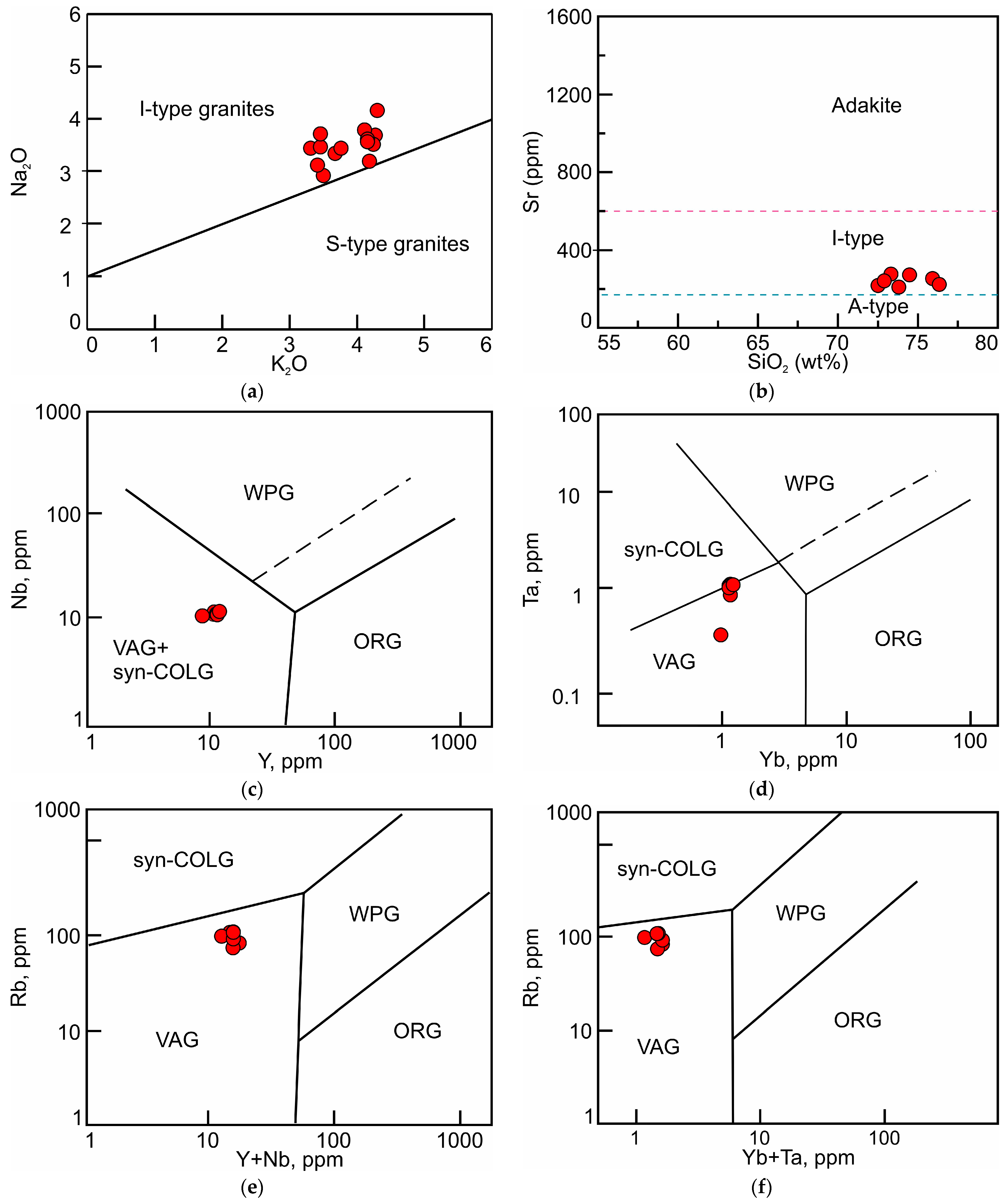
In the Na2O + K2O−CaO vs. SiO2 diagram (Figure 9A,B), the points of the studied granites fall within the calc-alkaline rock field, overlapping the fields of I-, S-, and A-type granites. The K2O vs. Na2O ratio (Figure 15a) indicates that the studied granites are I-type granites, albeit leaning towards the boundary with S-type. The strontium content, as seen in Figure 15b, also shows the affiliation of the granites to I-type granitoids. However, the relatively low strontium content also brings them closer to anorogenic granites. All samples align with the characteristics of I-type granites. The A/CNK index for the Arganaty granites is less than 1.1, as is the case for most granitoids in the Balkhash region [21,22]. Considering that I-type granites are characterized by both meta-aluminous and peraluminous compositions, and the A/CNK index of 1.1 marks the boundary between I- and S-types, along with the presence of titanite as an accessory mineral [51], it can be inferred that the Arganaty massif granites belong to the I-type.
Geodynamic discriminant diagrams (Figure 15c–f) show that the Arganaty granites exhibit characteristics of volcanic arcs, although they partially lie on the boundary between the volcanic arc and collision granite fields. In Figure 15e,f, the characteristics of volcanic arcs are much more pronounced, and all points of the studied granites from the Arganaty massif fall within the field of volcanic arc granitoids. The fact that Arganaty granites partially lie on the boundary between volcanic arc and collision granite fields may be explained by the theory that during the formation of the granites in the magmogenerating chamber, the assimilation of an older island-arc volcanic substrate took place.
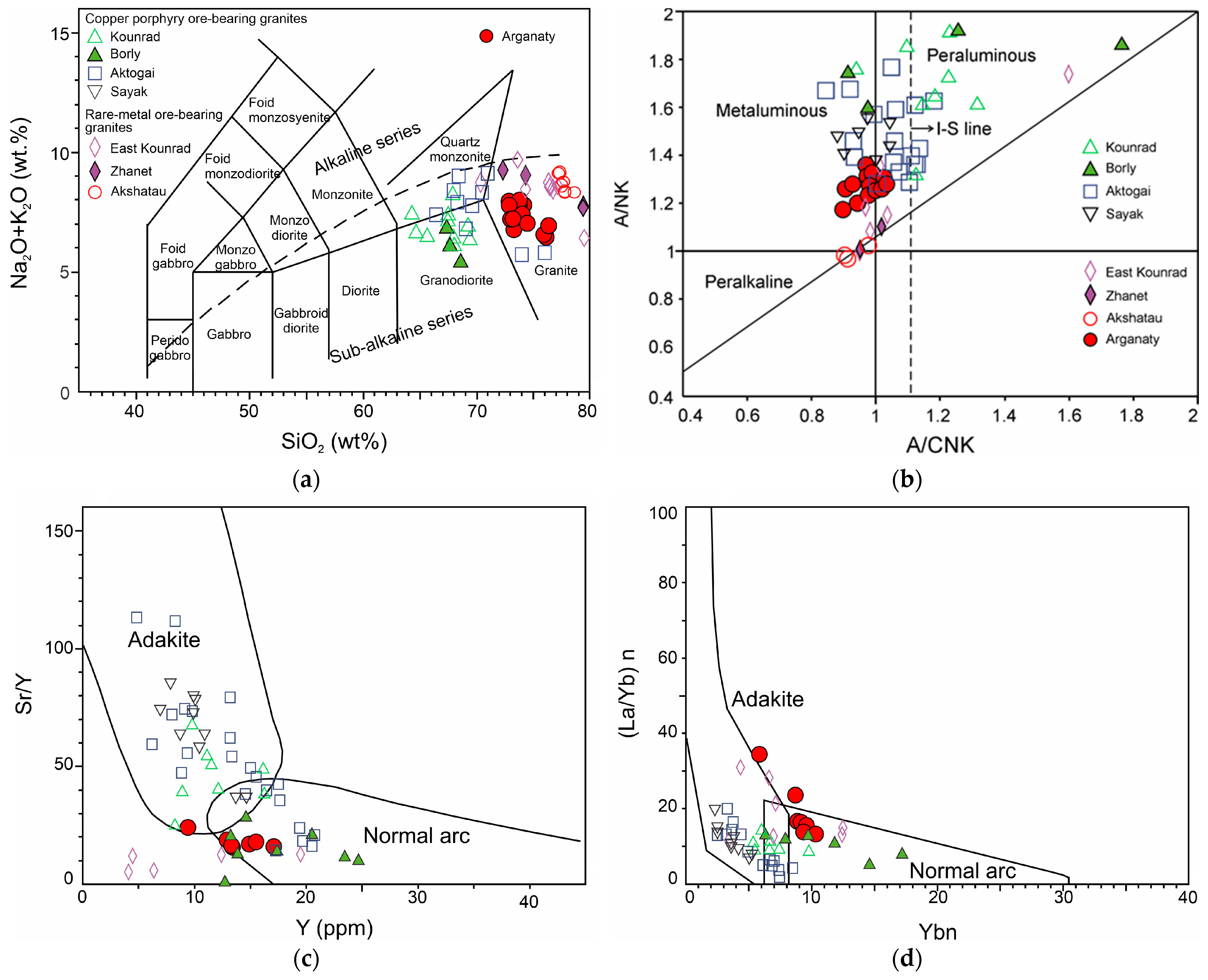
In terms of the ratio of silica and alkalis, the Arganaty granites have characteristics that correspond to an intermediate position between ore-bearing granites of copper-porphyry and rare-metal deposits (Figure 16).
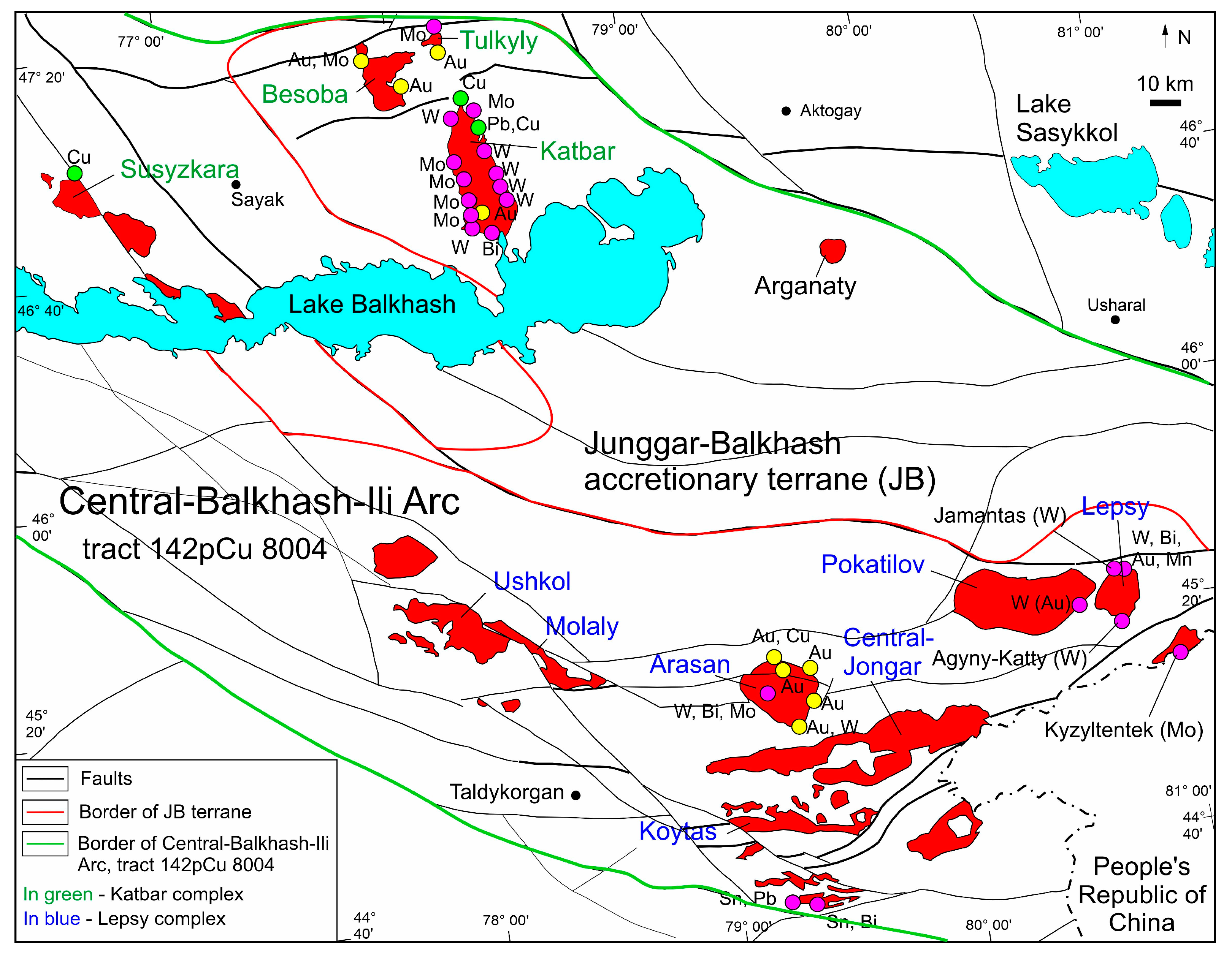
As noted above, the Arganaty massif has been attributed by several researchers to the Lepsy adamellite–granite complex, developed in Northern Zhongaria, while other authors have considered it an intrusive of the Katbar complex (Sayak region, Northern Balkhash) [41,42]. An analysis of geophysical studies of the massifs in Eastern Balkhash led researchers [42] to suggest a general northwest direction for the zones containing Permian intrusions of the Lepsy and Katbar complexes, and their connection to faults of the same direction. These complexes are associated with tungsten and molybdenum, as well as gold and copper mineralization [3,4,42] (Figure 17).
The region of granitoid massifs of the Lepsy and Katbar complexes is classified by some authors as a collision zone [14,35,36], which is associated with gold and rare-metal deposits in Kazakhstan [14,35,53]. Late Carboniferous–Permian granites of the rare-metal deposits in Eastern Kounrad, Janet, and Akshatau are also considered collision-related [53], but according to other researchers, they are products of the back-arc magmatic arc [14,36,60].
Granite intrusions associated with copper and molybdenum porphyry deposits in Northern Balkhash are considered to be related to subduction processes and are of Carboniferous age [53]. However, during the Permian period, collision started in Northern Balkhash and Southern Jongar (the Chinese part), which is associated with rare-metal deposit intrusions (Zhamantas, Agyny-katty, and Kyzyl-Tentek, see Figure 17).
The Arganaty massif region, according to [59], is located in the Junggar–Balkhash accretionary terrane. In the paleogeodynamic context, the area corresponds to the inner zone of the Balkhash–Ili Magmatic arc, ringed by the outer zone of the arc, strongly ore-bearing. The region of the Arganaty massif belongs to the Central Balkhash–Ili Arc. No Cu–Mo deposits are known within this tract, which covers an area of ~100,000 km2 and represents an area of permissive (potentially host, ore-bearing) rocks, largely under Neogene and Quaternary cover, Nevertheless, the tract is quite promising for the identification of copper (±molybdenum) porphyry deposits. According to estimates by Berger and co-authors [59], the mean (median) estimate of undiscovered copper resources is 7800 (2800) Kt, Mo—210 (25) Kt, Au—200 (42) t, correspondingly.

7. Conclusions

The granites of the Arganaty massif are high-potassium, calc-alkaline type I granites. The Arganaty granites have characteristics that are intermediate between copper–molybdenum and rare-metal granitoids. The genetic link of the Arganaty massif with copper–molybdenum–gold and tungsten–molybdenum granitoid massifs of Northern Jetysu and Northern Balkhash, along with the confirmed copper–molybdenum mineralization by drilling, suggests that this region has potential for copper–molybdenum and tungsten–molybdenum mineralization. Further research could provide new insights into the geological structure, geodynamics, and ore mineralization of the area for forecasting and assessing the resources for industrial mining.

Author Contributions

Conceptualization, A.B., I.V. and D.M.; methodology, I.V. and D.M.; investigation, A.B. and D.M.; resources, A.B.; writing—original draft preparation, A.B. and D.M.; writing—review and editing, I.V. and D.M.; visualization, D.M. and K.B.; supervision, A.B.; project administration, A.B.; funding acquisition, A.B. All authors have read and agreed to the published version of the manuscript.

Funding

This research was funded by the Science Committee of the Ministry of Science and Higher Education of the Republic of Kazakhstan: Grant No. AP14870909.

Data Availability Statement

The original contributions presented in the study are included in the article, further inquiries can be directed to the corresponding author.

Acknowledgments

The authors express their gratitude to A.I. Yakushev (IGEM RAS, Moscow, Russia) for performing the X-ray fluorescence analysis (XRF), and to V.K. Karandashev (Institute of Microelectronics Technology and High Purity Materials RAS in Chernogolovka, Moscow Region, Russia) for conducting the ICP-MS analyses. The authors also thank A.M. Kurchavov and I.D. Sobolev (IGEM RAS, Moscow, Russia) for their advice on certain aspects of the article.

Conflicts of Interest

The authors declare no conflicts of interest.

References

  1. Abdullin, A.A. Geology and Mineral Resources of Kazakhstan; Gylym: Almaty, Kazakhstan, 1994; 400p. (In Russian) [Google Scholar]
  2. Kolesnikov, V.V. Deposits of Non-Ferrous Metals. In Series: Balkhash Segment; Gylym: Alma-Ata, Kazakhstan, 1991; 192p. (In Russian) [Google Scholar]
  3. Liu, G.; Chen, X.H.; Dong, S.W.; Chen, Z.L.; Han, S.Q.; Yang, Y.; Ye, B.-Y.; Shi, W. Geochemistry of late Palaeozoic granitoids of the Balkhash metallogenic belt, Kazakhstan: Implications for crustal growth and tectonic evolution of the Central Asian Orogenic Belt. Intern. Geol. Rev. 2016, 59, 1053–1081. [Google Scholar] [CrossRef]
  4. Bekzhanov, G.R.; Koshkin, V.Y.; Nikitchenko, I.I.; Skrinnik, L.I.; Azizov, T.M.; Timush, A.V. Geological Structure of Kazakhstan; Academy of Mineral Resources of the Republic of Kazakhstan: Almaty, Kazakhstan, 2000; 396p. (In Russian) [Google Scholar]
  5. Heinhorst, J.; Lehmann, B.; Ermolov, P.; Serykh, V.; Zhurutin, S. Paleozoic crustal growth and metallogeny of Central Asia: Evidence from magmatic-hydrothermal ore systems of Central Kazakhstan. Tectonophysics 2000, 328, 69–87. [Google Scholar] [CrossRef]
  6. Seitmuratova, E.Y. Late Paleozoic Volcanogenic and Volcanogenic-Sedimentary Formations of the Junggar-Balkhash Folded Area: (Stratigraphy, Geological-Petrological Features). Almaty, Kazakhstan, 2002; 254p. (In Russian) [Google Scholar]
  7. Seitmuratova, E.Y. Late Paleozoic of the Junggar-Balkhash Folded Area (Kazakhstan) (Stratigraphy, Magmatism, History of the Continental Margin Formation in the Late Paleozoic); LLP Evero: Almaty, Kazakhstan, 2011; 279p. (In Russian) [Google Scholar]
  8. Yakubchuk, A. Evolution of the Central Asian Orogenic Supercollage since late Neoproterozoic revised again. Gondwana Res. 2017, 47, 372–398. [Google Scholar] [CrossRef]
  9. Degtyarev, K.E.; Luchitskaya, M.V.; Tretyakov, A.A.; Pilitsyna, A.V.; Yakubchuk, A.S. Early Paleozoic suprasubduction complexes of the North Balkhash ophiolite zone (Central Kazakhstan): Geochronology, geochemistry and implications for tectonic evolution of the Junggar-Balkhash Ocean. Lithos 2021, 380, 105818. [Google Scholar] [CrossRef]
  10. Baibatsha, A.B. Geotectonics and geodynamics of paleozoic structures from the perspective of plume tectonics: A case of Kazakhstan. GEOMATE J. 2020, 19, 194–202. [Google Scholar] [CrossRef]
  11. Baibatsha, A.B. Geotectonics and Geodynamics of Kazakhstan Paleozoides from the Plume Tectonics Position (Kazakhstan). In Advances in Geophysics, Tectonics and Petroleum Geosciences, Advances in Science, Technology & Innovation, Proceedings of the Conference of the Arabian Journal of Geosciences 2019, Sousse, Tunisia, 25–28 November 2019; Meghraoui, M., Sundararajan, N., Banerjee, S., Hinzen, K.-G., Eshagh, M., Roure, F., Chaminé, H.I., Maouche, S., Michard, A., Eds.; Springer: Cham, Switzerland, 2022; pp. 573–575. [Google Scholar] [CrossRef]
  12. Zvezdov, V.S.; Migachev, I.F.; Girfanov, M.M. Porphyry copper deposits of the CIS and the models of their formation. Ore Geol. Rev. 1993, 7, 511–549. [Google Scholar] [CrossRef]
  13. Miroshnichenko, L.A.; Zhukov, N.M. Geodynamic Settings of Formation and Prospective Assessments of Copper Metallogenic Complexes in Kazakhstan. Izv. NAN RK Ser. Geol. 2006, 6, 10–17. (In Russian) [Google Scholar]
  14. Zhukov, N.M.; Antonenko, A.A.; Goykolova, T.V. Prospects of Marginal Volcano-Plutonic Belts and Associated Structures of Kazakhstan for Priority Mineral Resources. Izv. NAN RK Ser. Geo. Technol. Sci. 2014, 5, 28–39. (In Russian) [Google Scholar]
  15. Shatov, V.; Seltmann, R.; Kremenetsky, A.; Lehmann, B.; Popov, V.; Ermolov, P. Granite-Related Ore Deposits of Central Kazakhstan and Adjacent Areas; Glagol Publishing House: St. Petersburg, Russia, 1996; 400p, ISBN 5 853 81122 3. [Google Scholar]
  16. Mao, J.; Pirajno, F.; Lehmann, B.; Luo, M.; Berzina, A. Distribution of porphyry deposits in the Eurasian continent and their corresponding tectonic settings. J. Asian Earth Sci. 2014, 79, 576–584. [Google Scholar] [CrossRef]
  17. Seltmann, R.; Porter, T.M. The porphyry Cu-Au/Mo deposits of Central Eurasia: 1. Tectonic, geologic and metallogenic setting and significant deposits. In Super Porphyry Copper and Gold Deposits: A Global Perspective, V.2; PGC Publishing: Adelaide, Australia, 2005; pp. 467–512. [Google Scholar]
  18. Baibatsha, A.; Omarova, G.; Dyussembayeva, K.; Kassenova, A. Kokkiya—A promising for Kazakhstan gold-metasomatic type of deposit. In Proceedings of the International Multidisciplinary Scientific GeoConference Surveying Geology and Mining Ecology Management, SGEM 2016, Albena, Bulgaria, 28 June–7 July 2016; pp. 289–296. [Google Scholar] [CrossRef]
  19. Baibatsha, A.; Arshamov, Y.; Bekbotayeva, A.; Baratov, R. Geology of the main industrial types of copper ore deposits in Kazakhstan. In Proceedings of the International Multidisciplinary Scientific GeoConference Surveying Geology and Mining Ecology Management, SGEM 2017, Vienna, Austria, 27–29 November 2017; Volume 17, pp. 231–238. [Google Scholar] [CrossRef]
  20. Antonenko, A.A.; Zhukov, N.M.; Gerzen, L.Y.; Goikolova, T.V. Features of mineral and element composition of poor ores of deposits Aktogay and Bozshakol. News Natl. Acad. Sci. Repub. Kazakhstan Ser. Geol. Tech. Sci. 2016, 4, 18–27. (In Russian) [Google Scholar]
  21. Li, G.; Cao, M.; Qin, K.; Hollings, P.; Evans, N.J.; Seitmuratova, E.Y. Petrogenesis of ore-forming and pre/post-ore granitoids from the Kounrad, Borly and Sayak porphyry/skarn Cu deposits, Central Kazakhstan. Gondwana Res. 2016, 37, 408–425. [Google Scholar] [CrossRef]
  22. Li, G.; Cao, M.; Qin, K.; Evans, N.J.; Hollings, P.; Seitmuratova, E.Y. Geochronology, petrogenesis and tectonic settings of pre- and syn-ore granites from the W-Mo deposits (East Kounrad, Zhanet and Akshatau), Central Kazakhstan. Lithos 2016, 252, 16–31. [Google Scholar] [CrossRef]
  23. Zeilik, B.S. The Arganaty cosmogenic crater in southern Kazakhstan and the ring structures associated with it. Dokl. Akad. Nauk SSSR 1987, 297, 925–928. (In Russian) [Google Scholar]
  24. Baibatsha, A.B.; Muszynski, A. Geological-geophysical prospecting indicators of the Arganaty district predictive blocks (Eastern Balkhash). News Natl. Acad. Sci. Repub. Kazakhstan Ser. Geol. Tech. Sci. 2020, 2, 31–39. [Google Scholar] [CrossRef]
  25. Baratov, R.T. Ring Structures of Central Kazakhstan and Their Ore Bearing Using Processed Remote Sensing (ERS). Ph.D. Thesis, Kazakh National Research Technical University named after K.I. Satpayev, Almaty, Kazakhstan, 2020. (In Russian). [Google Scholar]
  26. Mikheeva, A.V. General laws of spatial-temporal distribution of the Earth’s impact structures. Bull. Novosib. Comput. Cent. Ser. Math. Model. Geoph 2010, 13, 127–139. [Google Scholar]
  27. Barash, M.S. Interaction of the reasons for the mass biota extinctions in the Phanerozoic. Oceanology 2013, 53, 739–749. [Google Scholar] [CrossRef]
  28. Barash, M.S. Mass extinction of ocean organisms at the Paleozoic-Mesozoic boundary: Effects and causes. Oceanology 2012, 52, 238–248. [Google Scholar] [CrossRef]
  29. Baibatsha, A.; Omarova, G.; Shakirova, G. Innovative technologies of mineral resources predictioin on covered territories. In Proceedings of the International Multidisciplinary Scientific GeoConference, SGEM 2019, Vienna, Austria, 9–11 December 2019; Volume 19, pp. 271–278. [Google Scholar] [CrossRef]
  30. Muratkhanov, D.; Kembayev, M.; Sayat, R. A new approach to the forecast of porphyry copper deposits on the buried territories of Kazakhstan. In Proceedings of the International Multidisciplinary Scientific GeoConference, SGEM 2023, Albena, Bulgaria, 2–11 July 2023; Volume 23, pp. 3–9. [Google Scholar] [CrossRef]
  31. Muratkhanov, D.B.; Bulegenov, K.U.; Kembayev, M. About the new porphyry copper mineralization object in the Eastern Balkhash region (Kazakhstan). In Proceedings of the XXIVth International Multidisciplinary Scientific GeoConference Surveying, Geology and Mining, Ecology and Management, SGEM 2024, Albena, Bulgary, 29 June–8 July 2024. [Google Scholar]
  32. Bekzhanov, G.R.; Abdrakhmanov, K.A.; Afonichev, N.A.; Bespaev, H.A.; Lyapichev, G.F. Geological Map of Kazakhstan. Scale 1: 1,000,000; Saint Petersburg Cartographic Factory of The All-Russian Geological Research Institute of A.P. Karpinsky: Saint Petersburg, Russia, 1996. [Google Scholar]
  33. Daukeyev, S.Z.; Ushkenov, B.S. Deep Structure and Mineral Resources of Kazakhstan. Deep Structure and Geodynamics; Republican State Enterprise Information and Analytical Center of Geology and Mineral Resources of the Republic of Kazakhstan: Almaty, Kazakhstan, 2002; Volume 1, 224p. (In Russian) [Google Scholar]
  34. Windley, B.F.; Alexeiev, D.; Xiao, W.; Kröner, A.; Badarch, G. Tectonic models for accretion of the Central Asian Orogenic Belt. J. Geol. Soc. 2007, 164, 31–47. [Google Scholar] [CrossRef]
  35. Zhukov, N.M.; Antonenko, A.A.; Goikolova, T.V. Structure and Metallogeny of the Marginal Volcanoplutonic Belts of Kazakhstan. Proc. NAS RK. Ser. Geol. Technol. Sci. 2013, 5, 3–12. (In Russian) [Google Scholar]
  36. Zholtaev, G.Z.; Antonenko, A.A.; Zhukov, N.M. Atlas of the Distribution Patterns of Solid Mineral Resources of Kazakhstan. Institute of Geological Sciences named after K.I. Satpaev: Almaty, Kazakhstan, 2023; 265p. (In Russian) [Google Scholar]
  37. Korobkin, V.V.; Buslov, M.M. Tectonics and geodynamics of the western Central Asian Fold Belt (Kazakhstan Paleozoides). Russ. Geol. Geophys. 2011, 50, 1585–1603. [Google Scholar] [CrossRef]
  38. Pertsov, A.V. (Ed.) Aerospace Methods of Geological Research; Karpinsky Russian Geological Institute (VSEGEI): St. Petersburg, Russia, 2000; 316p. (In Russian) [Google Scholar]
  39. Ananyev, Y.S.; Potseluev, A.A.; Zhitkov, V.G.; Nazarov, V.N.; Kuznetsov, A.S. Space-Structural Criteria of Sulfide-Polymetallic Mineralization of the Zyryanovsk Ore Field. Geol. Bowels Earth 2010, 2, 32–39. (In Russian) [Google Scholar]
  40. Baibatsha, A.B.; Potseluev, A.A.; Ananyev, Y.S. Methodology for Geological Interpretation of Satellite Images to Identify Hidden Ore-Controlling Structures. Proc. NAS RK Ser. Geol. Technol. Sci. 2013, 6, 66–73. (In Russian) [Google Scholar]
  41. Chimbulatov, M.A.; Bespalov, V.F.; Kostenko, N.N. Explanatory Note, Geological Map of the Kazakh SSR, Scale 1:500,000, South Kazakhstan Series; Leningrad Cartographic Factory of the Aerogeology Association: Leningrad, Russia, 1981; 248p. (In Russian) [Google Scholar]
  42. Bekzhanov, G.R. Deep Structures and Copper-Porphyry Mineralization of the Junggar-Balkhash Fold System; Nauka: Alma-Ata, Kazakhstan, 1984; 232p. (In Russian) [Google Scholar]
  43. Abdullin, A.A.; Lyapichev, G.F.; Nikitchenko, I.I.; Nurlybayev, A.N. Magmatic Complexes of Kazakhstan. Junggar-Balkhash Fold System; Nauka: Alma-Ata, Kazakhstan, 1983; 216p. (In Russian) [Google Scholar]
  44. Palme, H.; Lodders, K.; Jones, A. Solar System Abundances of the Elements. In Planets, Asteriods, Comets and The Solar System of Treatise on Geochemistry, 2nd ed.; Andrew, M.D., Ed.; Elsevier: Amsterdam, The Netherlands, 2014; Volume 2, pp. 15–36. [Google Scholar]
  45. Middlemost, E.A. Naming materials in the magma/igneous rock system. Earth-Sci. Rev. 1994, 37, 215–224. [Google Scholar] [CrossRef]
  46. Shand, S.J. Eruptive Rocks: Their Genesis Composition, Classification, and Their Relation to Ore-Deposits with a Chapter on Meteorite; John Wiley & Sons: Hoboken, NJ, USA, 1943. [Google Scholar]
  47. Maniar, P.D.; Piccoli, P.M. Tectonic Discrimination of Granitoids. Geol. Soc. Am. Bull. 1989, 101, 635–643. [Google Scholar] [CrossRef]
  48. Peccerillo, A.; Taylor, S.R. Geochemistry of Eocene calc-alkaline volcanic rocks from the Kastamonu area, northern Turkey. Contrib. Mineral. Petrol. 1976, 58, 63–81. [Google Scholar] [CrossRef]
  49. Frost, B.R.; Barnes, C.G.; Collins, W.J.; Arculus, R.J.; Ellis, D.J.; Frost, C.D. A geochemical classification for granitic rocks. J. Petrol. 2001, 42, 2033–2048. [Google Scholar] [CrossRef]
  50. Frost, C.D.; Frost, B.R.; Beard, J.S. On silica-rich granitoids and their eruptive equivalents. Am. Miner. 2016, 101, 1268–1284. [Google Scholar] [CrossRef]
  51. Chappell, B.W.; White, A.J.R. Two contrasting granite types: 25 years later. Aust. J. Earth Sci. 2001, 48, 489–499. [Google Scholar] [CrossRef]
  52. Pearce, J.A.; Harris, N.B.; Tindle, A.G. Trace element discrimination diagrams for the tectonic interpretation of granitic rocks. J. Petrol. 1984, 25, 956–983. [Google Scholar] [CrossRef]
  53. Shen, P.; Pan, H.; Xiao, W.; Chen, X.; Eleonorad, S.; Shen, Y. Two geodynamic-metallogenic events in the Balkhash (Kazakhstan) and the West Junggar (China): Carboniferous porphyry Cu and Permian greisen W-Mo mineralization. Int. Geol. Rev. 2013, 55, 1660–1687. [Google Scholar] [CrossRef]
  54. Shen, P.; Pan, H.; Seitmuratova, E. Petrogenesis of the mineralized granitoids from the Kounrad and Borly porphyry Cu deposits and the East Kounrad porphyry Mo deposit in Kazakhstan: Implication for tectonic evolution and mineralization of the western part of the Central Asian Orogenic Belt. Lithos 2017, 286, 53–74. [Google Scholar] [CrossRef]
  55. Shen, P.; Pan, H.; Hattori, K.; Cooke, D.R.; Seitmuratova, E. Large Paleozoic and Mesozoic porphyry deposits in the Central Asian Orogenic Belt: Geodynamic settings, magmatic sources, and genetic models. Gondwana Res. 2018, 58, 161–194. [Google Scholar] [CrossRef]
  56. Li, C.; Shen, P.; Pan, H.; Seitmuratova, E. Control on the size of porphyry copper reserves in the North Balkhash–West Junggar Metallogenic Belt. Lithos 2019, 328, 244–261. [Google Scholar] [CrossRef]
  57. Cao, M.J.; Li, G.M.; Qin, K.Z.; Evans, N.J.; Seitmuratova, E.Y. Assessing the magmatic affinity and petrogenesis of granitoids at the giant Aktogai porphyry Cu deposit, Central Kazakhstan. Am. J. Sci. 2016, 316, 614–668. [Google Scholar] [CrossRef]
  58. Defant, M.J.; Drummond, M.S. Derivation of some modern arc magmas by melting of young subducted lithosphere. Nature 1990, 347, 662–665. [Google Scholar] [CrossRef]
  59. Berger, B.R.; Mars, J.C.; Denning, P.D.; Phillips, J.D.; Hammarstrom, J.M.; Zientek, M.L.; Dicken, C.L.; Drew, L.J.; Alexeiev, D.; Seltmann, R.; et al. Porphyry Copper Assessment of Western Central Asia: U.S. Geological Survey Scientific Investigations Report 2010–5090–N; U.S. Geological Survey: Reston, VA, USA, 2014; 219p. [Google Scholar] [CrossRef]
  60. Akylbekov, S.A.; Votsalevskyi, E.S.; Gulyayev, A.P.; Zhukov, N.M.; Miroshnichenko, L.A.; Petrov, N.N.; Rakishev, B.M.; Uzhkenov, B.S. Mineragenic Map of Kazakhstan at a Scale of 1:1,000,000, Explanatory Note; The Computer Publishing Center of the Public Organization “Voluntary Society of War Invalids in Afghanistan of the Medeu District of Almaty”: Alma-Ata, Kazakhstan, 2007; 180p. (In Russian) [Google Scholar]
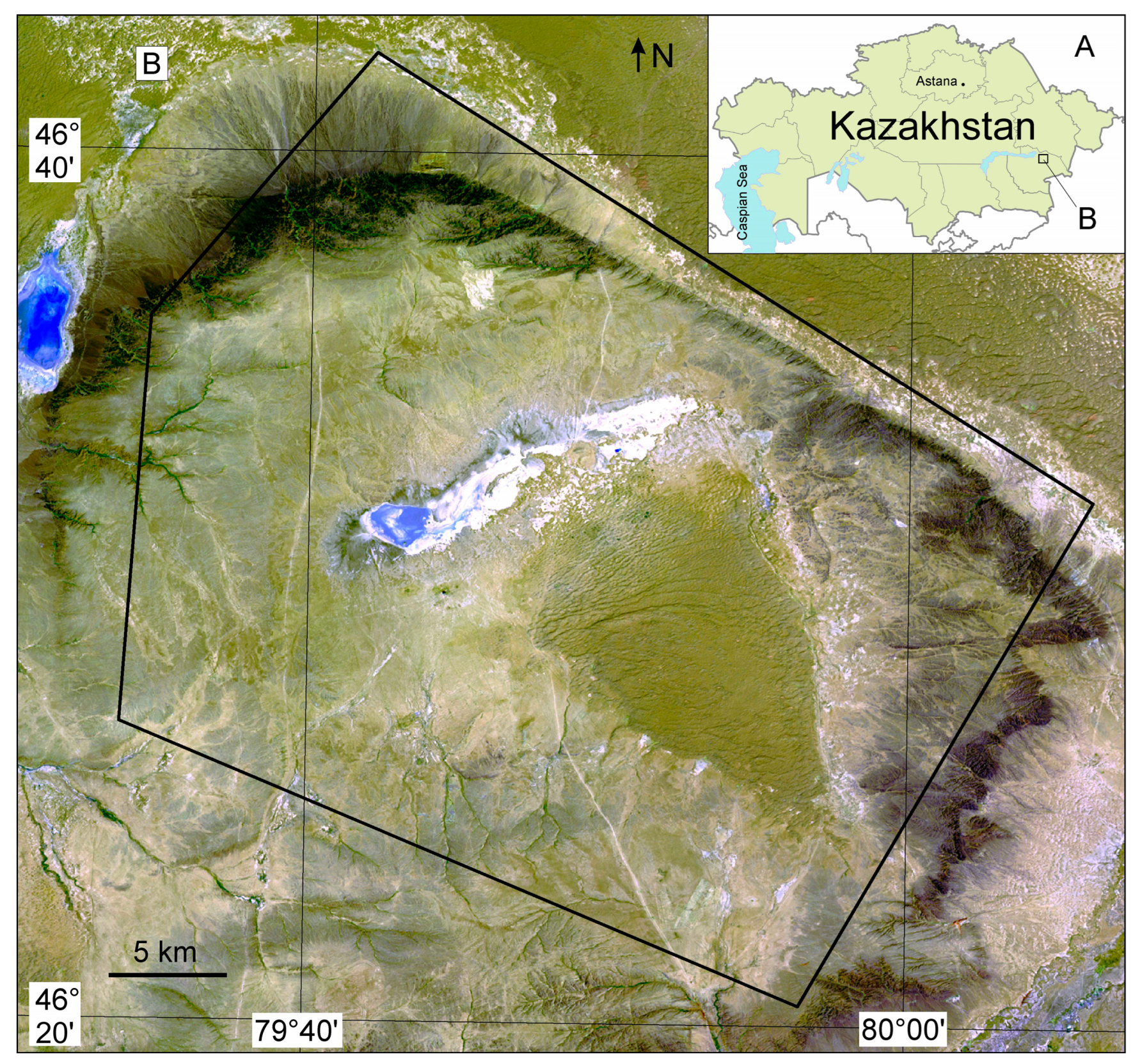
Figure 3. A—Location of the Eastern Balkhash region on a map of Kazakhstan; B—Borders of the Arganaty district on the Landsat ETM+ map.
Geosciences 14 00237 g003
Figure 4. Structural map of the Arganaty area (modified after [31]).
Geosciences 14 00237 g004
Figure 5. Photos of Arganaty massif samples. (a) and (b)—hole samples of porphyritic granite.
Geosciences 14 00237 g005
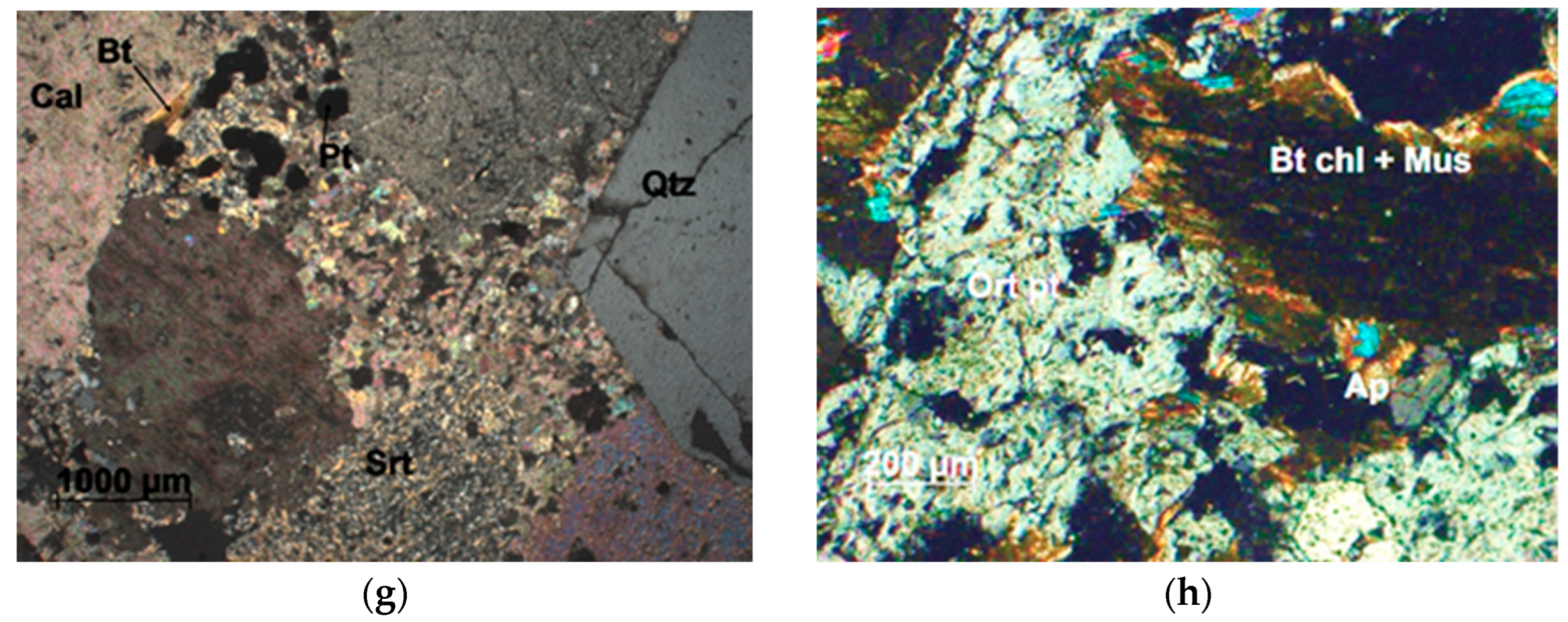
Figure 6. Microscopic photographs of typical intrusive rocks and hydrothermal formations of the Arganaty massif. (ad) Porphyritic biotite granite; (e) Quartz vein: serrated grains of vein quartz (Qtz), calcite (Cal) in microfractures, non-crosscutting; (f,g) Quartz–sericite–calcite metasomatite; (h) Chlorite–quartz–albite metasomatite. Abbreviations in figures: Bt—biotite; Bt chl—chlorited biotite; Cal—calcite; Mgt—magnetite; Mus—muscovite; Ort—orthoclase; Ort pt—orthoclase perthite; Pl—plagioclase; Pl alb—plagioclase (albite); Pl srt—sericited plagioclase; Qtz—quartz; Spn—sphene; Srt—sericite.
Geosciences 14 00237 g006aGeosciences 14 00237 g006b
Figure 7. Arganaty granites on the classification diagram of granitoids using a TAS diagram [45] (SiO2 vs. Na2O + K2O).
Geosciences 14 00237 g007
Figure 8. Geochemical characteristics of Arganaty granites in A/CNK vs. A/NK diagram [46,47].
Geosciences 14 00237 g008
Figure 9. Classification of Arganaty granites according to different chemical schemes. Red circles are composition points of Arganaty granite samples. (A) SiO2 (wt.%) vs. K2O (wt.%) (after [48]); (B) SiO2 (wt.%) vs. Na2O + K2O − CaO (wt.%) (after [49]); (C) FeOt/(FeOt + MgO) vs SiO2 (after [50]).
Geosciences 14 00237 g009
Figure 10. Harker diagrams for major oxides vs. SiO2 for granites of the Arganaty massif.
Geosciences 14 00237 g010
Figure 11. Harker diagrams for micro elements vs. SiO2 for granites of the Arganaty massif.
Geosciences 14 00237 g011
Figure 12. Chondrite-normalized rare earth elements (REE) spider diagram for the Arganaty granites (chondrite composition according to [44]).
Geosciences 14 00237 g012
Figure 13. Primitive mantle-normalized trace elements diagram for the Arganaty granites (the composition of the primitive mantle according to [44]).
Geosciences 14 00237 g013
Figure 14. (a)—Chalcopyrite (Cp) in quartz; (b)—Aggregates of titanomagnetite (1) with chalcopyrite (Cp) and pyrite (Py), with chalcopyrite free on the left; (c)—Corroded pyrite with small inclusions of chalcopyrite; (d)—Molybdenite (Mo) developing along a crack in quartz; (e)—Molybdenite penetrating into aggregate pyrite; (f)—Corroded pyrite in quartz with inclusions of molybdenite; (g)—Galena (Gn) inclusions in pyrite; (h)—Sphalerite (Sl) in association with pyrite; (i)—Pyrite aggregate with inclusions of sphalerite (1); (j)—Small aggregate of molybdenite, galena, and hessite (Hs) in pyrite; (k)—Titanomagnetite (1) with ilmenite (2) in a titanite (3) aggregate; (l)—Close association of magnetite (1) with hematite (2) and inclusions of titanomagnetite (3) in titanite (4); (m)—Titanomagnetite (1) with ilmenite (2) breaking down structure, corroded pyrite grain with chalcopyrite inclusion; (n)—Titanomagnetite (1) replaced by ilmenite (2), titanite (3); (o)—Rutile replacing ilmenite (1), (2)—titanite.
Geosciences 14 00237 g014aGeosciences 14 00237 g014b
Figure 15. Discrimination diagrams of Arganaty granites. Red circles are composition points of Arganaty granite samples. (a) Na2O vs. K2O diagram discriminating I-type and S-type granitic rocks [51]; (b) Sr vs. SiO2; (cf)—the position of the composition points of the studied granites from the Arganaty massif in the discriminant diagrams for determining the geodynamic settings of granitoid formation [52]. syn-COLG—syn-collision granites, VAG—volcanic arc granites, WPG—within plate granites, and ORG—ocean ridge granites. The dashed line in (c,d) represents the upper compositional boundary for ORG from anomalous ridge segments.
Geosciences 14 00237 g015
Figure 16. Comparison of the chemical composition of the studied Arganaty granites with the compositions of granitoids from other deposits in Central Kazakhstan: (a) on the TAS classification diagram for granitoids [46] (SiO2 vs. Na2O + K2O), (b) on A/CNK vs. A/NK diagram [46,47]; (c) diagram of Sr/Y vs Y; (d) diagram of (La/Yb)N vs YbN. Data for other deposits borrowed from the works of [21,22,53,54,55,56,57]. (c,d)—diagram plots from [58]).
Geosciences 14 00237 g016
Figure 17. Schematic map showing the location of granitoid massifs of the Lepsy and Katbar complexes, with associated ore deposits indicated. Borders of the Junggar–Balkhash terrane and Central Balkhash–Ili Arc are from [59].
Geosciences 14 00237 g017
Table 1. Major (wt.%) and trace elements (ppm) abundance of rocks from the Arganaty massif.
SampleAR5-7AR5-9
*
AR5-10
*
AR5-12AR5-39AR5-40
*
AR5-66
*
AR8-27AR8-28AR8-36
*
AR8-73
*
AR8-119
*
AR9-111
SiO272.9074.1876.1273.8172.5174.0572.9175.9273.3273.0274.4873.2476.34
TiO20.280.270.240.270.300.270.330.300.370.360.360.350.22
Al2O313.2313.3111.3013.1812.9112.4212.2311.7512.5912.6911.9812.8212.04
∑Fe2O32.761.713.162.053.542.842.752.393.482.752.663.041.60
MnO0.0520.0450.1660.0470.0660.0470.0510.0460.0670.0440.0570.0690.030
MgO0.500.430.440.420.510.520.570.540.700.580.630.590.40
CaO1.561.361.311.501.631.311.751.662.062.062.071.891.56
Na2O3.823.542.953.643.713.233.603.143.463.753.363.463.48
K2O4.114.243.504.164.274.184.163.423.313.463.673.763.46
P2O50.080.030.060.080.100.070.100.100.110.110.120.120.07
LOI0.490.610.520.630.270.811.170.430.290.740.370.300.47
V30.6496027.326.1373628.735.13934.16417.1
Cr16.119239.015.21002910.418.83137.22025.6
Co4.8<10<104.62.7<10<104.05.5<104.1<104.8
Ni14.5<10105.715.110<108.613.4<1010.1125.2
Ga15.8 16.015.5 13.915.2 14.2 13.4
Rb11711210411912112111096.688.29292.79699.1
Sr242233226210218158172254277276273246225
Y12.911613.413.3131414.915.51617.1159.4
Ba492501533489507455530566608586631551473
La34.8 485.35.4 35.230.4 32.4 47.6
Ce57.0 69.260.0 61.457.7 62.6 62.2
Pr5.2 5.85.6 5.85.9 6.4 5.0
Nd17.5 17.818.6 20.221.1 23.4 15.4
Sm2.9 2.73.2 3.63.7 4.2 2.4
Eu0.65 0.590.67 0.710.78 0.84 0.52
Gd2.2 2.02.4 2.72.8 3.1 1.7
Tb0.32 0.280.35 0.390.41 0.46 0.25
Dy1.9 1.72.1 2.32.4 2.7 1.5
Ho0.39 0.360.42 0.460.49 0.55 0.30
Er1.2 1.11.3 1.41.4 1.6 0.86
Tm0.21 0.200.21 0.220.22 0.26 0.15
Yb1.5 1.51.6 1.61.6 1.8 0.99
Lu0.26 0.250.27 0.280.26 0.30 0.16
Pb20.1331319.121.6232115.113.41815.82014.3
Th11.610918.211.381425.810.9108.91118.4
U1.8<5<53.12.47695.52.8<56.0<56.5
Nb12.7131314.614.7131613.112.31615.11510.3
Ta1.0 1.11.1 1.30.94 1.2 0.60
Zr10313611991.198.112913513010412910813964.7
Hf3.2 2.73.2 3.82.7 3.3 2.0
* The trace elements for the samples are provided based on XRF results.
Disclaimer/Publisher’s Note: The statements, opinions and data contained in all publications are solely those of the individual author(s) and contributor(s) and not of MDPI and/or the editor(s). MDPI and/or the editor(s) disclaim responsibility for any injury to people or property resulting from any ideas, methods, instructions or products referred to in the content.