Article

The Contributions of Tectonics, Hydrochemistry and Stable Isotopes to the Water Resource Management of a Thermal–Mineral Aquifer: The Case Study of Kyllini, Northwest Peloponnese

by
Vasiliki Stavropoulou
1,
Anastasia Pyrgaki
2,
Eleni Zagana
1,*,
Christos Pouliaris
3 and
Nerantzis Kazakis
1
1
Laboratory of Hydrogeology, Department of Geology, Faculty of Natural Sciences, University of Patras, Rio, 26504 Patra, Greece
2
Decentralized Administration of Peloponnese, Western Greece and the Ionian, Athinon Str. 105, 26500 Patra, Greece
3
School of Mining and Metallurgical Engineering, Zografou Campus, National Technical University of Athens, Iroon Polytechniou 9, 15773 Athens, Greece
*
Author to whom correspondence should be addressed.
Geosciences 2024, 14(8), 205; https://doi.org/10.3390/geosciences14080205
Submission received: 1 June 2024 / Revised: 16 July 2024 / Accepted: 30 July 2024 / Published: 2 August 2024
(This article belongs to the Section Hydrogeology)

Abstract

:
This study aims to investigate the intricate relationship between geological structures, water chemistry, and isotopic composition in order to gain a deeper understanding of the origins and recharge mechanisms of thermal–mineral waters in the Kyllini region. The research integrates tectonic analysis, hydrochemical data, and stable isotope measurements to delineate recharge zones and trace the origin of these unique water sources. The methods used for delineation are the geological and tectonic study of the area, as well as hydrochemical and isotopic data analysis. The findings highlight that tectonic activity creates preferential flow paths and consequently influences the hydrogeological framework, facilitating deep circulation and the upwelling of thermal waters. Monthly analyses of groundwater samples from the Kyllini thermal spring were conducted over one hydrological year (2019–2020) and compared with data from the area collected in 2009. The hydrochemical profiles of major and minor ions reveal distinct signatures corresponding to various water–rock interactions, while stable isotope analysis provides insights into the climatic conditions and altitudes of recharge areas. Hydrochemical analyses reveal the composition of thermal–mineral waters, aiding in the identification of potential sources and their evolution. The conceptualization of Kyllini contributes to the deeper understanding of the intricate interplay between tectonics, hydrochemistry, and stable isotopes. During a hydrological year, the water type of Kyllini’s spring groundwater remains the same (Na-Cl-HCO3), presenting only slight alterations.

1. Introduction

In the Mediterranean region, groundwater constitutes the main source of water for domestic, industrial, and agricultural activities. However, the quality deterioration of groundwater from natural and anthropogenic sources threatens the water supply. Usually, studies focus on anthropogenic pollution sources [1,2,3,4]. However, at some sites, the hydrogeological regime favors groundwater pollution from natural processes. Greece has one of the most active tectonic plate boundaries in Europe, where the Eurasian and African plates collide. This convergence gives rise to recurring seismic activity and a heightened susceptibility to earthquakes. Tectonic structure provides a flow path for deeper fluids and minerals, influencing geological processes and resource distribution. Tectonic structures can significantly influence fluid-flow behavior in the Earth’s crust. These structures vary from simple fault geometries to complex fault zones with multiple strands, impacting fluid-migration patterns [5]. The presence of hydraulic heterogeneities within rocks can control the spatial distribution of deformation structures, affecting fault architecture and fluid-flow pathways over time [6]. For instance, tectonic activity creates faults in impermeable rocks, which can lead to the formation of pathways for fluid migration, potentially altering the subsurface hydrology, and influencing geothermal energy resources and even seismic activity.
In terms of water requirements, thermo-metallic waters are considered unsuitable; hence, tectonic behavior is a contributing factor to water chemistry and pollution. Nonetheless, it is crucial to acknowledge the therapeutic properties of thermo-metallic waters, which have been utilized for centuries in practices such as positotherapy and bathing [7,8].
Tectonic behavior is a key determinant that shapes the subsurface landscape and influences the intricate pathways through which groundwater sustains ecosystems and human communities. In general, tectonic setting plays a significant role in hydrogeology by influencing the structure, flow paths, and characteristics of groundwater systems. Tectonic activity can impact the drainage evolution and hydrogeological setting of a region. Fault systems, in particular, can act as flow barriers or preferential flow paths, affecting groundwater flow towards specific areas [9]. In polyorogenic regions, complex fractured bedrock aquifers are formed due to the superposition of structures during tectonic history [10]. Tectonic structures can also impact the permeability patterns of aquifers, affecting groundwater quantity and quality [11]. Additionally, faults can play a role in directing groundwater flow towards preferential drainage areas [12]. Moreover, faults have the potential to exert a profound impact on the hydrodynamics of aquifers, as well as the hydrochemistry of the system. Consequently, such influence can result in alterations to the flow regimes within an aquifer and ultimately affect the observed salinity levels within the surrounding region [13]. Major faults can impact salinity by affecting hydraulic conductivity, leading to differences in permeability within geological formations. This influence can result in increased salinization potential in shallow aquifers near fault zones. Additionally, the presence of faults can influence salt tectonics, such as salt diapirism, which further contributes to the distribution of salinity in areas such as the study area. Understanding these geological features is crucial for assessing and managing salinity risks in regions like Kyllini [14].
Geological structures such as faults and fractures play a crucial role in guiding groundwater flow [15]. These structures can act as conduits or barriers to groundwater flow, depending on their orientation and permeability [16]. In some cases, tectonic activity can lead to the diversion of groundwater flow along fault lines [17]. Additionally, the emergence of faults due to tectonic perturbations may affect the safety of groundwater repositories, depending on their proximity and timing [17]. In continental rift zone settings, faults can control groundwater flow within different sub-compartments, leading to spatial heterogeneity in flow patterns. Strong seismic events have the capability to induce alterations in the movement of groundwater, such as shifts in flow pathways and changes in the amount of water being discharged. These modifications occur as a result of fractures created during earthquakes and the subsequent influence of faults in either facilitating or impeding the flow of water [18]. Seismic events can also affect the physico-chemical characteristics of groundwater, with anomalies observed before, during, and after earthquakes [19]. Additionally, the tectonic modification of the landscape can impact surface drainage systems and groundwater residence in aquifers, with correlations between fault systems, potentiometric anomalies, and lithospheric thickness [20].
Thermal springs are abundant in Greece, especially in tectonically active regions, many of which are located in the western part of the country. Since ancient times, Kyllini has been known for its healing springs, and their possible connection to neighboring aquifers has been a source of interest for many researchers [21,22,23]. The ancient Greeks believed in the medicinal properties of these waters and utilized them for treating a variety of health conditions [24]. The famous historian Herodotus mentioned the therapeutic use of mineral waters in his writings, indicating the long-standing significance of such natural resources in Greek culture. During the Roman period, the Kyllini springs were further developed into elaborate bath complexes. Romans, known for their sophisticated bathing culture, capitalized on the natural thermal–mineral waters, constructing baths that served both therapeutic and social functions. The mineral content, particularly chloride and bicarbonate, is known to help in treating skin conditions like eczema, psoriasis, and dermatitis [7]. The thermal properties of the waters provide relief from the pain and inflammation associated with arthritis, rheumatism, and other musculoskeletal issues [25]. The inhalation of steam from these waters can alleviate symptoms of respiratory conditions such as asthma and bronchitis. Today, the thermal–mineral springs of Kyllini continue to be a popular destination for wellness tourism. Modern spas and therapeutic centers in the region utilize these natural resources, offering a range of treatments and wellness programs that draw on the historical legacy of the springs. The region is very close to the Hellenic Trench, which is one of the most seismically active regions in Greece. Deep fault systems and fissured zones, along with the presence of permeable rock such as limestone, favor the preferential flow of deep groundwater to surface fresh water, influencing groundwater quality [26]. Mount Erymanthos consists of carbonate rock interrupted by active faults, allowing the circulation of meteoric water at great depths, resulting in its enrichment in trace elements such as lithium and boron [22].
Tectonic activity can result in the formation of geothermal systems. Thermal springs and geothermal reservoirs often occur in regions with active tectonics, where heat from the Earth’s interior influences groundwater temperature and movement. Studies have shown that seismic events can affect the physico-chemical characteristics of groundwater, leading to variations in conductivity, temperature, and major and minor constituents [16]. Active tectonics can also control the movement of groundwater in hard-rock aquifer systems, resulting in the formation of alternating groundwater valleys and ridges that coincide with tectonic arches and deeps [19]. Additionally, tectonic activity can cause changes in the position of rivers, leading to shifts in groundwater flow patterns and changes in groundwater quality [27]. The presence of fault systems and fractures in aquifer complexes can also influence the movement and characteristics of groundwater, as observed in the Cerna Valley Basin, where hydrogeothermal phenomena are strongly influenced by tectonic activity [28]. Overall, these findings highlight the close relationship between tectonic activity and the movement of thermo-mineral groundwater. Understanding the interaction between fluids and fault systems is crucial in hydrogeology, as faults can influence the displacement of deep fluids and the recharge processes of groundwater systems.
Hydrochemistry is a valuable tool for investigating the origin, quality, and potential applications of thermal waters. For instance, studies on various thermal springs have classified them based on cation and anion percentages, such as NaCl, NaHCO3, and CaHCO3 types [29]. Additionally, geochemical calculations and water analysis aid in understanding the stability, mineral solubility, and low mineral salt content of thermal waters controlled by natural geochemical equilibria [30]. Furthermore, the classification of thermal waters into different groups based on salinity levels and chemical facies provides information on their suitability for irrigation and potential environmental risks [31]. Moreover, in another case, hydrochemistry can be used to determine if arsenic and boron are derived from geothermal fluids, or if hexavalent chromium is derived from the weathering products of ophiolitic rocks [32]. In summary, hydrochemical analyses are essential for characterizing thermal waters and groundwater in general, as well as evaluating their quality and determining their potential applications across various fields.
Isotopes play a vital role in hydrochemical research as they offer valuable insights into the age, origin, and movement of water within the hydrological cycle. Stable isotopes, such as oxygen-18 and deuterium, are employed to track water sources, comprehend groundwater recharge processes, and investigate hydrochemical properties [33]. These isotopes facilitate the identification of the evolution of groundwater systems under the influence of human activities, the determination of predominant water types, and the disclosure of the hydrochemical characteristics of water resources [34]. Furthermore, stable isotopes assist in the study of isotope composition in precipitation, revealing seasonal variations influenced by rainfall volume and ambient air temperature. This knowledge contributes to a comprehensive understanding of water resources and their interactions with the environment.
In this study, we investigate the origin and thermal and/or mineral properties of water. A sampling network consisting of 13 springs and boreholes has been established in the western Peloponnese to examine the mechanisms that control the origin and genesis of the local water. Our study aims to identify the similarities and differences among various springs in the broader area of the northwestern Peloponnese, using a multi-parameter approach that includes main, trace element, and stable isotope analyses. The estimation of Kyllini’s recharge zone is based on a comprehensive geological and hydrogeological study of the wider area of the Kyllini Baths, combined with data from previous studies. The findings of this research project will enhance our understanding of the hydrochemical and hydrogeological behavior of groundwater in the study area.

2. Materials and Methods

2.1. Study Area

The study area is located in the northwestern Peloponnese in Greece, extending into the northern part of the Ilia prefecture. It is characterized by the presence of hypothermal–mineral springs and is developed in an E-W direction from Erymanthos M. to the sea. The peninsula of Kyllini, which is about 868 km2, extends to the western part of the Pinios River Basin. The river drains the mountainous and semi-mountainous zone of the study region and flows into Chelonitis Bay (Figure 1). The population of the study area is approximately 9000, which increases during the summer due to tourism. The main economic activity in the area is centered around agriculture, particularly summer crops such as strawberries, watermelon, and pumpkin. In the summer, the water demands in the basin are primarily met through groundwater, while surface water from the Pinios Dam supplements this supply during the winter (and to a lesser extent in the summer). Given the current climate crisis, it is imperative to protect both the quantity and quality of groundwater, as it is a crucial resource in this region.
The climate in the western Peloponnese region is characterized by hot and arid summers, along with mild and rainy winters. During the summer months, temperatures often surpass 35 °C, accompanied by ample sunshine. On the contrary, winters are relatively mild, with intermittent rainfall. Coastal areas experience milder temperatures due to the moderating influence of the nearby sea, while inland regions experience more noticeable temperature variations.
In the wider area, the dominant geological formations are post-Alpine orogenesis-type rocks. The geological substratum of the region consists of Alpine formations, which have a limited surface expansion. The Alpine sediments belong to the geotectonic zones of Olonos Pindos, Gavrovo–Tripolis, and Ionia, as they develop from east to west and belong to the External Hellenides. East of the Ilia prefecture, the entire stratigraphic sequence of the Pindos Zone outcrops on the surface of Erymanthos Mountain, with characteristic imbricate thrust stacks (Figure 1). Τhe lithostratigraphic units of the Pindos Zone consist of clastic Triassic series, Drumos limestones of Up. Triassic to L. Jurassic age, radiolarites of M. Jurassic to L. Cretaceous age, first flysch, platy limestones of Up. Cretaceous age, transitional layers of flysch, and flysch of Holocene age. The Gavrovo–Tripolis Zone begins east of Pinios Lake and the appearance of sediment is limited to Mount Skolis, mainly comprising Upper Eocene–Oligocene flysch [35].
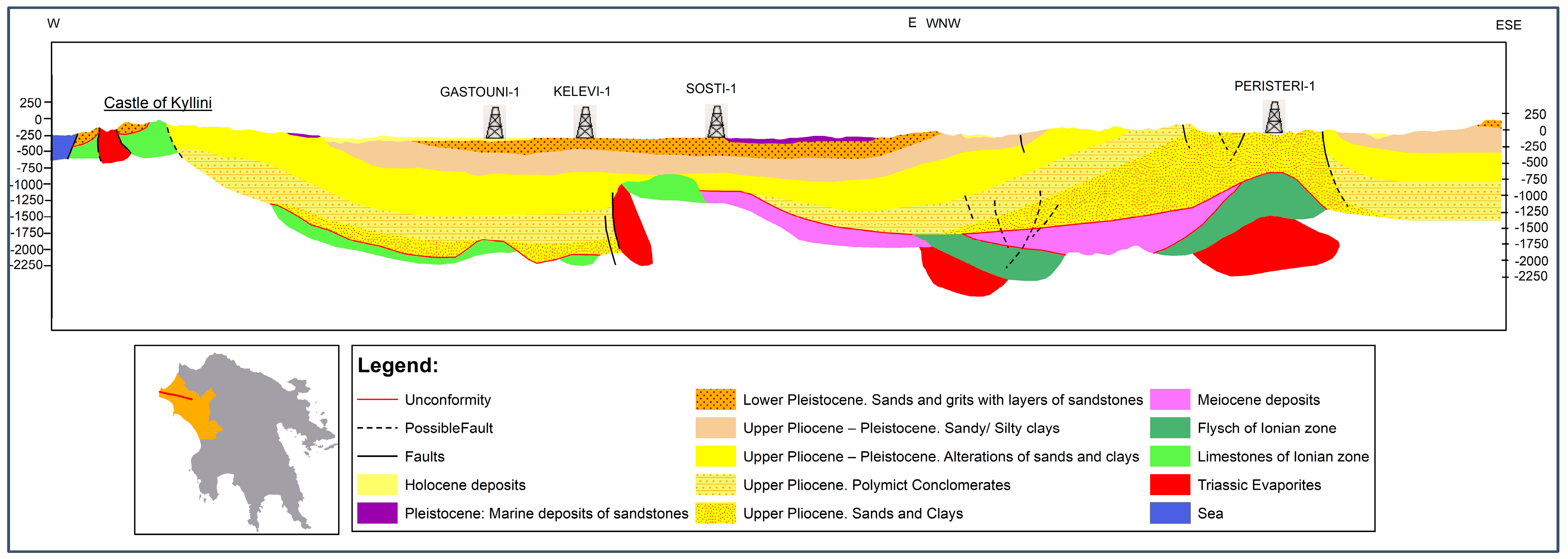
Evaporites of Triassic age, which belong to the base of the Ionian Zone, and limestones of Middle Jurassic–Upper Cretaceous age, appear north of the Kyllini Baths. Gypsum of diapiric origin is strongly deformed and folded with linear and flat flow lines [3]. The diapiric movement of Triassic evaporites has affected both Alpine and Late-Cenozoic-to-Holocene sedimentary rocks, and is associated with thrust faults, which could be pathways for the upward migration of groundwater (Figure 2). Diapiric activity is still ongoing today [36]. Moreover, near the village of Kastro, “Vigla limestones” from the Upper Jurassic to L. Cretaceous age superficially appear with insertions of cherts.
The post-Alpine deposits in the study area, within which the hot springs occur, constitute the northern part of Pyrgos Basin, which extends from Mount Lapithas to the edges of Mount Skolis and Kyllini [37]. Post-Alpine sedimentary formations of Plio-Pleistocene and Holocene age are placed unconformably on the Alpine formations in this area and cover the greater area of the peninsula. These sediments consist of alternating layers of marls, clays, sands, coarse- and fine-grained sandstones, and conglomerates [38].
The western Peloponnese, and especially Kyllini, is characterized as one of the most tectonically active areas in Greece. The main reason for the intense neotectonic activity is that the area is located close to the outer part of the Greek Arc and close to the convergence zone of the lithospheric plates [39,40]. The tectonic setting of the Northwestern Peloponnese is characterized by the presence of the Corinthian rift, which is the most active extensional crustal structure in the world [41]. This rift has shaped the region since the Pliocene through normal faulting, tectonic uplift, and sea level changes [42]. The landscape changes from the coast line into the mainland from a flat plain to mountainous, with different sedimentary deposits and geological features [43]. The region has challenging conditions for geophysical surveys due to its complex geological formations and the human utilization of the coastal plain and urban areas [44]. Various geophysical techniques such as magnetic mapping, ground-penetrating radar (GPR), electrical resistivity tomography (ERT), and seismic soundings have been used to overcome these challenges and successfully map archaeological features and structures [45].
In the NW Peloponnese, the result of actions of the main neotectonic faults from the Upper Miocene to the present day is the creation of alternating trenches and horsts, which are determined by large marginal fault zones in the neotectonic basin with a general E-W direction. These faults are characterized as being very seismically active [40,46]. Specifically, the tectonic horst of Erymanthos has developed in the study area with a NE-SW direction of Pindos geological structures; this is due to the general E-W direction of faults in this area and the depression of Ilia, which is bounded to the north by the Erymanthos tectonic horst and to the south by the Lapitha tectonic horst. The post-Alpine basin of the study area extends to the northern part of the depression of Ilia and is one of the smallest structures delimited within it by major fault zones [47] as a result of a combination of fault tectonics (mainly feedback from pre-existing axes of Alpine tectonics) in combination with the diapiric movements of the evaporites of the Ionian Zone [37]. The presence of a Late Triassic–Early Cenozoic succession of deep-water siliciclastic, carbonate, and siliceous sediments, which become more distal oceanward towards the east, provides evidence for the tectonic development of the Pindos Ocean [43]. The flexural upwarp and subsequent collapse of the Gavrovo–Tripolis foreland basin during the Mid-Eocene and Late Eocene, respectively, demonstrate the tectonic evolution of the Pindos ocean and its interaction with the surrounding regions [43].
The Pindos Zone constitutes an overthrust nappe lying on the formations of the Gavrovo–Tripolis Zone, a large part of which is covered, and intense tectonic action has caused the formation of imbricate thrust stacks. Especially in the study area, the Pindos Zone is overthrusted on the flysch of the Gavrovo–Tripolis Zone on the east side of the anticline of Mount Skolis. According to Kamberis, the structural limit between the Ionian and Gavrovo–Tripolis Zones is a result of the latest up-thrusting, which passes through the villages of Portes and Santameri. The structural deformation in the Ionian and Gavrovo Zones in the NW Peloponnese is attributed to the propagation of a fold–thrust system during the Cenozoic [31]. The Pindos Flysch Formation in the Peloponnese was derived from the Apulian continental margin to the west and was deposited in channels with levees and channel-termination lobes in the western Peloponnese, as well as in a distal basin plain in the east. It was later incorporated into the accretionary prism by Mid-Eocene time due to a microcontinental collision south of the Gulf of Corinth line [48]. Diapirs of Triassic evaporites complicate the tectonic pattern in front of the Skolis thrust in the mentioned basins. The structural deformation in the Ionian and Gavrovo–Tripolis Zones is attributed to the propagation of a fold–thrust system during the Cenozoic. The Gavrovo–Tripolis Zone has experienced high-angle reverse faulting, which has generated an imbricate fan [49].
In the Kyllini peninsula, the Ionian Zone formations form an asymmetric anticlinic structure of N-S general orientation parallel to the west coast, resulting in the intersection of gypsum in combination with the effect of faults and tangential movements. The axis of the anticlines plunges abruptly north of Kyllini Spring, while at Chelonitis Bay, the plunge seems to have a slight slope. This is most likely because of the faults that developed around the spring, resulting in the plunge of Alpine substratum to Chelonitis Bay. In the Upper Pliocene–Pleistocene, the area converted into a shallow coast and a sequence of transgression and regression of the sea took place. Τhis resulted in the old relief being covered by the Upper Pliocene–Pleistocene sediments that developed in the region [21,37]. The diapirism of the gypsum continued from the Pleistocene to the Holocene due to the alteration in the Alpine substratum, with the consequence of the upward movement of the area. In general, the Kyllini anticline structure is characterized by a composite geometry and complexity due to the diapirism of the gypsum, which is enhanced by the action of faults parallel to the axis of the anticline, but also by tangential thrust movements [21].

2.2. Methodology

To carry out this study and assess variations in groundwater quality, monthly samples were collected from Kyllini Spring between the years 2019 and 2020. Additionally, for the cross-comparison of the aquifer and the spring, data were evaluated from June 2009. In total, we took thirteen samples from springs and boreholes, as well as two samples from the sea and rainfall. The sampling network was strategically chosen to ensure a comprehensive distribution across the broader study area and due to accessibility reasons. It was considered essential to collect samples of both freshwater and thermal–mineral water at various altitudes. It is important to evaluate both time-series data and previous data in order to evaluate the evolution of the environmental status of aquifers.
Immediately after collection, all analyses were conducted at the Laboratory of Hydrogeology of the Department of Geology at the University of Patras. Three distinct water samples were obtained from each sampling site and placed in polyethylene bottles that had been thoroughly cleaned with acid and rinsed. The first sample, with a volume of 1 L, was used for the analysis of anions (NO3, NO2, SO42−, Cl, and F) in the water. The second sample, with a volume of 0.1 L, was filtered through a Whatman 0.45 μm cellulose membrane and then treated with 0.5 mL of ultrapure HNO3 to determine the presence of metals (Ca2+, K+, Mg2+, and Na+). The third sample was a bulk sample used for isotopic analyses.
Temperature, pH, electrical conductivity, dissolved oxygen, and redox potential were measured in situ using a Hanna® HI 9828, USA portable equipment (Hanna, Smithfield, RI, USA). Moreover, CO2 and alkalinity concentrations were measured in situ using a Hach® Digital Titrator (Hach, Loveland, CO, USA), and S2− was measured using a Hach® 2400 portable spectrophotometer. Anion (NO3, NO2, SO42−, and F), P, NH4+, and SiO2 concentrations were measured with a Hach® DR 4000 spectrophotometer. The Cl content was determined using AgNO3 0.1 N titration. Major cation (Ca2+, K+, Mg2+, and Na+) concentrations were determined using a Perkin Elmer atomic absorption spectrometer (PerkinElmer, Waltham, MA, USA). Chemical calculations, such as the determination of saturation indices, were performed using PHREEQC version 3.0 [50].
Trace-element concentrations were measured using inductively coupled plasma–mass spectrometry (ICP-MS) with an ELAN 6100 Perkin-Elmer instrument (PerkinElmer, Waltham, MA, USA). Moreover, all groundwater samples were also analyzed for their oxygen and hydrogen isotopic composition using an isotope ratio mass spectrometer (Finnigan Delta, Atlanta, GA, USA). Isotope ratios are expressed as the deviation per mile (d‰) from the reference V-SMOW (Vienna Standard Mean Ocean Water). The uncertainties are ±0.1‰ for d18O and ±1‰ for dD (±1 s). Isotopic analyses were carried out at the Institute of Geophysics and Volcanology of Palermo in Italy. Isotope analyses were used to determine the origin of the sources by means of a d18O-altitude diagram. The accuracy of the major element analyses was checked by using charge mass balance, and analyses were considered as acceptable when charge mass balance was less than 3%.

3. Results and Discussion

3.1. Hydrochemistry Characteristics

The electrical conductivity (E.C.) values of all samples ranged between 261.1 and 51,600 μS/cm, while the pH values ranged between 6.88 and 7.78 (Table 1). The majority of the samples were characterized by negative redox values, thus indicating reductive conditions, and the samples from karst springs presented positive redox values, showing an oxidative environment. In terms of temperature, the waters of the sampling network are classified into two categories: cold–fresh waters (STSIP, SAGKYR, SKAK, SXAB, GA2, GA3, S1), with temperatures ranging between 12.2 °C and 20.3 °C, and hypothermic–mineral waters (GA1, G8, SKYL, SBR, SKOU, GKOU), with temperatures ranging between 12.2 °C and 29 °C. The elevated temperature values of the groundwater in the Kyllini Baths is a significant indicator of the region’s hydrogeological settings. These temperatures result from deep groundwater circulation influenced by the Earth’s geothermal gradient and are facilitated by tectonic activity, such as fractures and faults that allow warm water to ascend to the surface. The temperature profiles also reflect extensive water–rock interactions, which contribute to the unique chemical composition of the thermal–mineral waters.
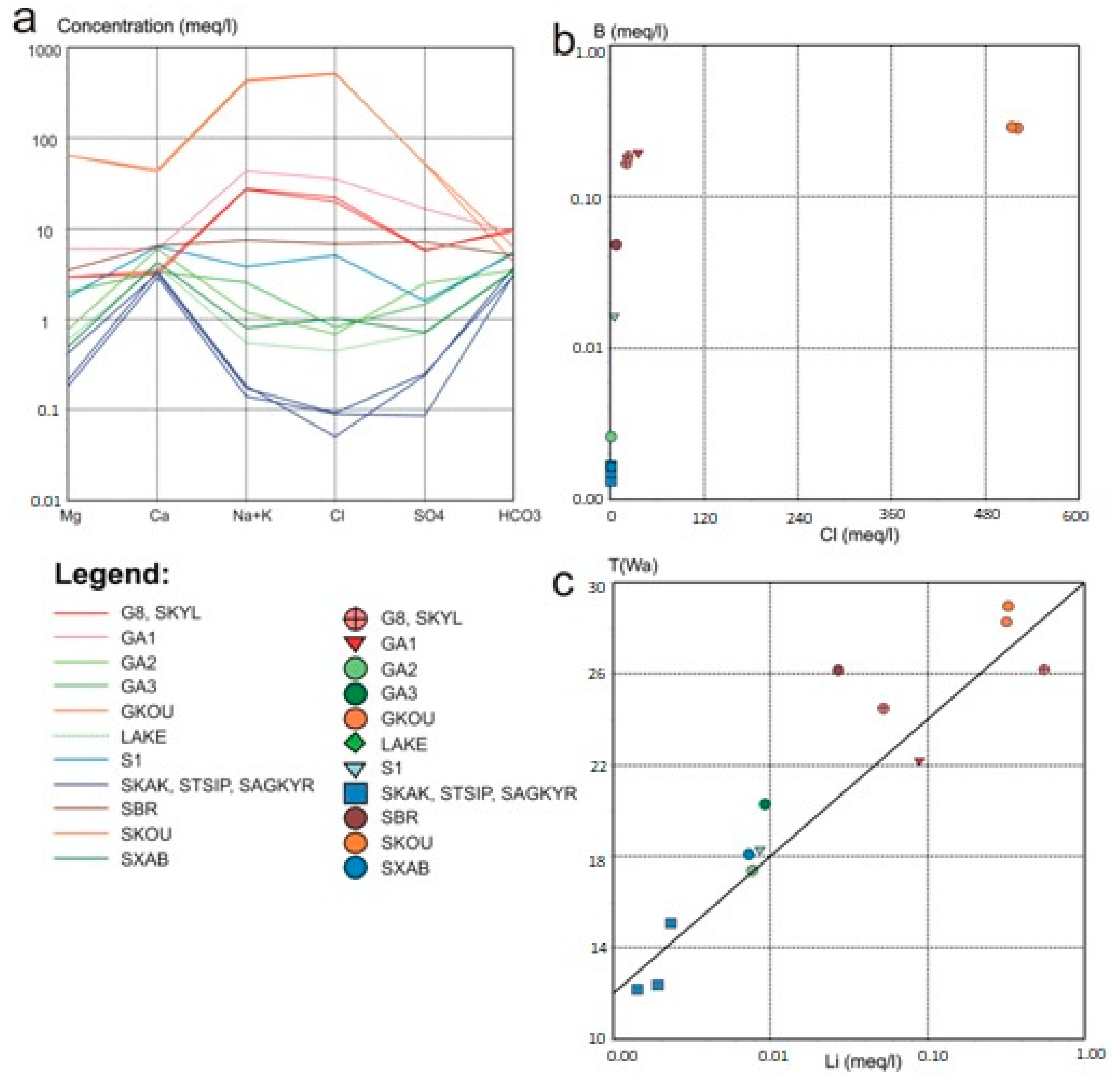
Water samples were plotted in a Piper diagram (Figure 3a) and in scatter plots (Figure 3b–e). The solid lines reflect the concentration–dilution characteristic line for seawater. According to the Piper and Shoeller (Figure 4a) diagrams, the fresh water samples of karst springs STSIP, SAGKYR, SKAK, and SXAB, and the sample from Pinios Lake have a water type of Ca-HCO3, which means that the waters are refreshed in limestone and sandstone. The springs discharge water from limestone, consequently filling the lake with karst spring water. As a result, the springs and the lake contain an identical water composition. The shallow borehole GA2 and the deep borehole GA3 have water types of Ca-HCO3-SO4-NO3 and Ca-Na-Mg-HCO3, respectively, while spring S1 has Ca-Na-HCO3-Cl. Obviously, different types of waters based on this classification are subjected to variable chemical processes, including dissolution, ion exchange, and mixing among waters. This is indeed expected for aquifers in Neogene–Quaternary formations, where low-flowing-speed water favors the initiation of these chemical processes.
According to Figure 3b, most samples are located on the concentration–dilution line, showing the same origin for the elements of Na and Cl. In hydrochemistry research that focuses on groundwater quality, the concentration–dilution line for seawater plays a crucial role in understanding the dynamics of mixing between groundwater and seawater, especially in coastal aquifers. Plotting the concentrations of different ions, such as chloride and sodium, against salinity allows us to determine the extent of seawater intrusion into the groundwater system. A straight concentration–dilution line indicates conservative mixing, suggesting that the observed concentrations are solely a result of physical mixing without significant chemical reactions. Deviations from this line can indicate non-conservative behavior, revealing geochemical interactions such as ion exchange or mineral dissolution that affect groundwater quality. Plotting the concentrations of different ions, such as chloride against sodium, also allows us to determine if the ions are of common origin. From the fresh water group, spring S1, located 500 m west of Kyllini Spring, seems to be affected by the thermal aquifer of Kyllini Spring and not by sea water. In Figure 3c, the distribution of the samples in relation to the dilution line shows the terrestrial origin of calcium (carbonate rocks) of all the samples and those of Kounoupeli Spring. The terrestrial origin of calcium is important in determining the quality of groundwater. Calcium primarily comes from the weathering of minerals found on land, like limestone and gypsum. This natural process enriches groundwater with calcium ions, which are essential for maintaining the water’s chemical balance and overall quality. The presence of calcium in groundwater indicates the geological characteristics of an aquifer and can affect water hardness. High levels of calcium can improve water’s buffering capacity, which helps to neutralize acidity and stabilize pH levels.
Moreover, pollution from anthropogenic activities is another factor increasing chloride ions in spring S1, spring Xavari (SXAB), and in Pinios Lake. The Cl-SO4 diagram indicates that sulfates (Figure 3d), especially in the samples which are on the dilution line, have the same origin as sea water. All samples, with the exception of Kounoupeli, that are on the line present a reasonable excess of sulfates due to the dissolution of dissoluble minerals such as gypsum and anhydrite. The increased concentrations of sulfates in the samples from both Kyllini and Vromoneri that were found in the same field are attributed to contact with Triassic evaporites. Due to diapirism, in both areas, the evaporites appear at the surface of the ground and at the subterranean level, i.e., very close to the surface [51].
On the other hand, the diagram in Figure 3e (Cl-Mg/Ca) shows the terrestrial origin of the two elements found in all samples, except those from Kounoupeli. The values of the Mg/Ca ratio range from 0.06 at Kakotari Spring to 1.51 at Kounoupeli Spring. In the GA3 borehole and Vromoneri Spring (SBR), the ratio presents values from 5 to 7, indicating origin from limestone aquifers, while for Kyllini Spring (G8, SKYL) and GA1, the origin is dolomitic and silicate aquifers.
The presence of dolomites in the evaporites of the Ionian Zone is known in the Castle of Kyllini [21,52], but they have also been found underground with deep drilling. Evaporites contain carbonate minerals, and the dissolution of gypsum or anhydride causes the dissolution of dolomite as well, according to Reaction (1):
1.8 CaSO4 + 0.8 CaMg (CO3)2 → 1.6 Ca (CO3)2 + Ca2+ + 0.8 Mg2+ + 1.8 SO4−2
The dissolution of gypsum releases abundant Ca2+ in the water, and continuous dissolution causes a precipitation of calcite, which, according to the reaction leads to a decrease in CO32−, causing the additional dissolution of dolomite with a simultaneous increase in the concentration of Mg2+. This process is referred to as dedolomitization and results in the deposition of calcite and an increase in the concentrations of Ca2+, Mg2+, and SO42− in groundwater.
In line with the trace element analysis, two samplings and analyses were conducted during separate dry and arid periods. The mineral and thermal waters presented high concentrations of B, Ba, Li, and Sr that did not change over time. This is strong evidence of the stable minerality of the thermal spring. The concentration of lithium in water depends on the contact time between water and rock [53]. In addition, Li has been used as an indicator of the residence time of water in aquifers [54]. The diagram of lithium and the temperature of the water samples (Figure 4c) in the study area shows the strong correlation between these factors. As the temperature increases, the concentration of lithium also increases. Boron, which has a high solubility, tends to be concentrated in restricted water environments, in evaporites, and in brackish waters of marine or continental origin [55]. The diagram of B-Cl (Figure 4b) shows that the ratios of boron to chloride support the origin of boron being from the dissolution of rock minerals, except for the Kounoupeli Spring (SKOU), which indicates an origin from mixing with seawater.
During hydrochemical monitoring in 2020, the water type of Kyllini Spring groundwater remained the same: Na-Cl-HCO3. During a hydrological year, a slight variation is observed in the values of temperature and pH, as well as in concentrations of main elements such as K+, Na+, Ca2+, SO42−, NO3, NO2, and NH4+. These elements present a low standard deviation, which indicates that the values tend to be close to the mean of the set. In general, changes in precipitation and temperature throughout the seasons impact the rates at which groundwater is recharged and the dilution of dissolved minerals. Specifically, natural processes like mineral dissolution, ion exchange, and microbial activity in groundwater samples vary seasonally, thereby affecting the concentrations of hydrochemical parameters. In addition, the values of EC, CO2, HCO3, and Cl show high standard deviation, which indicates that the values are spread out over a wider range. Table 2 shows the statistical results of the chemical analyses of the water samples from Kyllini thermal spring. The temperature of thermal waters varies from 24.1 °C to 28.7 °C, whereas the electrical conductivity ranges between 3869 μS/cm and 4495 μS/cm. The thermal spring shows a fractional fluctuation in pH values, which range from 7.18 to 7.44. Sodium (Na+) is the dominating cation in the sample site, varying between 820 and 900 mg/L (mean value 860 mg/L). Along with Na+, both chloride (Cl) (890–1100 mg/L) and bicarbonate (HCO3) (585.6–829.6 mg/L) contributed in considerable amounts to the hydrochemical composition of the samples. Calcium (Ca2+) shows a range of 54–100.4 mg/L with an average of 74.12 mg/L. The season does not affect the hydrochemical composition of the thermal water, despite changes in external weather conditions.
The radial plots for Kyllini Spring’s thermal water (Figure 5) indicate that a particular variation in the chemical composition of the water over the years does not exist. Although, a small proportional increase in the concentrations of the main elements is observed.

3.2. Isotopic Analysis

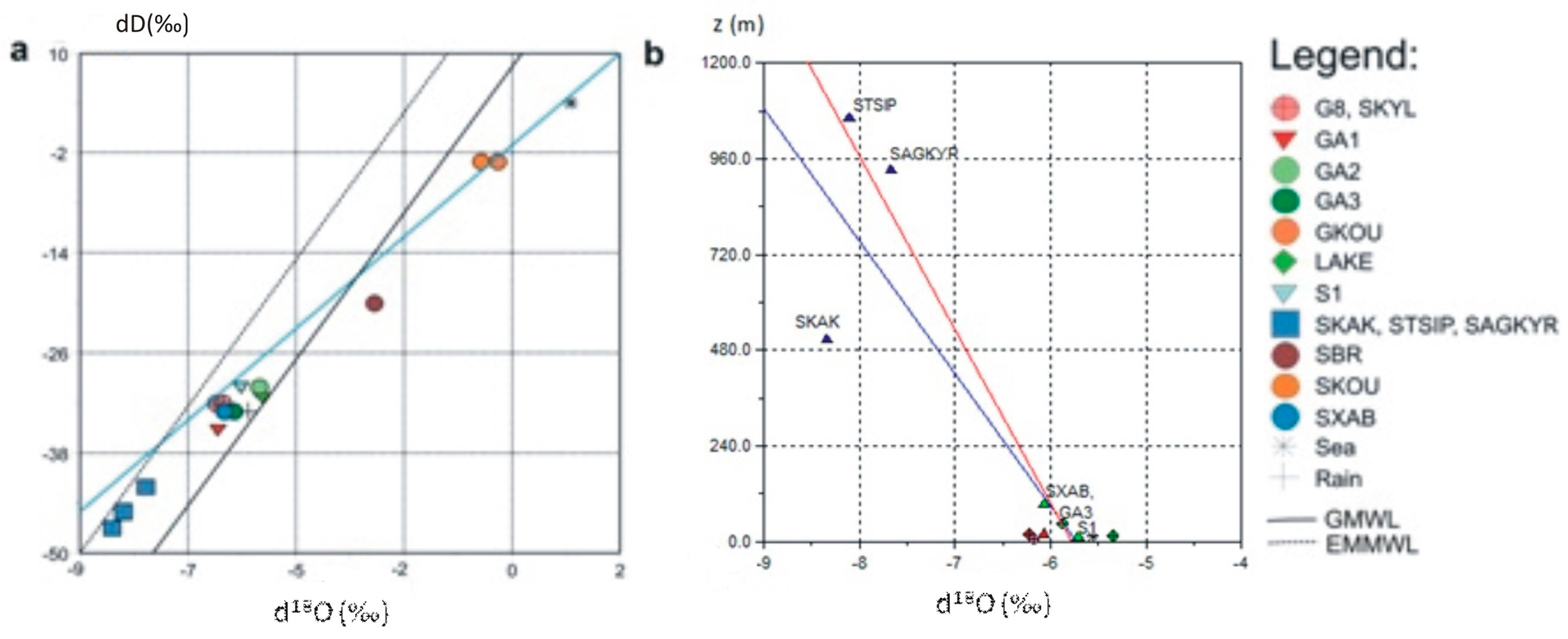
The comparison of the isotopic composition of the water samples indicated a common origin of the thermo-mineral waters and their possible recharge from the semi-mountainous zone near Pinios Lake (Figure 6). Semi-mountainous regions function as recharge zones where precipitation infiltrates the soil and permeable rock formations. This water gradually descends into deeper layers of the Earth’s crust, becoming enriched with minerals from the surrounding rocks and heating up due to the geothermal gradient. As a result, thermo-mineral waters are formed, which eventually surface through faults or fractures. These waters often carry a unique mineral composition, indicating their extended underground journey and geothermal history.
The isotopic analysis reinforced the conclusions of the hydrochemical analysis in relation to the origin of the waters. Isotopic signatures are essential for understanding water–rock interactions and providing insights into the geochemical processes that affect groundwater composition. Through the examination of stable isotope ratios, such as oxygen-18 (18O) and deuterium (2H), the origins, pathways, and historical movements of water within an aquifer can be traced. These isotopic markers provide information on the extent of water–rock interactions, as the isotopic composition of groundwater changes due to mineral dissolution, precipitation, and ion exchange. Moreover, isotopic variations indicate the mixing of different water sources and the influence of climatic conditions on groundwater recharge. The position at which the samples from Kounoupeli Spring appear on the diagram in Figure 6a (the top right near the seawater sample) indicates mixing with seawater, confirming the hydrochemical analysis. The blue line in Figure 6a corresponds to the correlation between groundwater samples, rain, and sea water.
Groundwater samples appear within the belt line zone and are divided into two groups. The first group includes springs that are formed in the limestones of the Pindos Zone, including the spring of Kakotari (SKAK), with the lowest isotopic compositions in terms d18O and dD values, and the rest of the samples are separated into thermo-mineral waters (SKYL, GA8, GA1, and SXAB) and fresh waters (GA3, GA2, GA1, and S1). From the diagram depicting d18O-z, it appears that Kakotari Spring (506 m) is supplied from altitudes higher than the altitude of the Tsipiana Spring (1062 m), as the water is depleted in 18O and D compared to the spring waters from Agia Kyriaki and Tsipiana. In Figure 6b, the red line corresponds to the high correlation coefficient r2 = 0.907 that all water samples have, except for Kakotari (SKAK). Moreover, it is proven that the supply of thermo-mineral waters is carried out from the semi-mountainous and mountainous regions.

3.3. Index Saturation

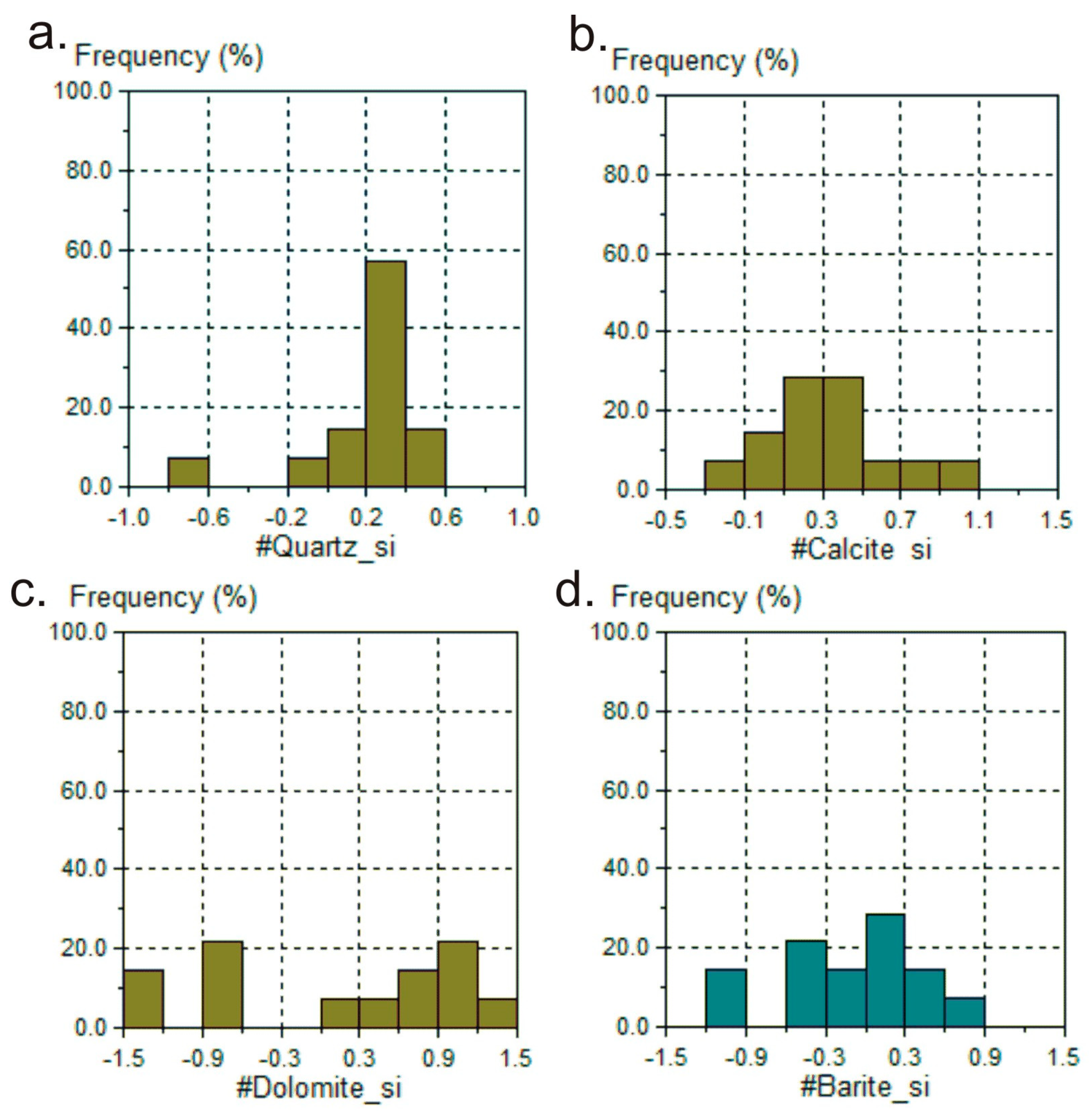
Saturation indices, calculated with the help of PHREEQC [50], show that the thermo-mineral waters of the study area appear saturated in quartz (SiO2), calcite (CaCO3), dolomite (CaMg(CO3)2), and barite (BaSO4). Knowing the degree of saturation is an indicator of the residence time of the water in the rock. Groundwater is in equilibrium with a mineral when the saturation index is zero, unsaturated when it is negative, and supersaturated when the index is positive.
The samples are saturated in quartz, apart from the Kakotari (SKAK) and Lake Pinios samples, and all are saturated in calcite except for Agia Kyriaki Spring (SAGKYR) and borehole GA2 (Figure 7). The only sample from the fresh water group that is saturated in barite is spring S1, which is also saturated in dolomite. In general, the waters of these samples had the ability to dissolve the corresponding minerals in quantities to reach saturation either because they were under conditions of high temperature or because they were in contact for a sufficient period of time with the corresponding minerals, or because of both of the above two reasons.
Kyllini’s mineral water possesses a wide range of minerals that give rise to its unique characteristics. The groundwater in this area is abundant in trace elements such as B, Sr, As, and Li, which display associations with temperature owing to interactions between the water and rocks [56]. In addition, the water contains elements like Ba, Cu, Fe, and Cd, which either exhibit no correlation or an inverse correlation with temperature, possibly due to oversaturation at higher temperatures [57]. In the current study, a correlation between lithium and temperature was observed, which is consistent with the results reported in the article of Li et al. (2021) [58]. In Greece, Kyllini’s mineral water is highly regarded for its unique qualities, which are derived from an abundance of different minerals, including magnesium, boron, and nitrate. These minerals are acquired through interactions with silicic rocks and shallow aquifers [59]. Dotsika et al. (2006) mentioned that the elevated boron concentrations found in the water samples can be primarily attributed to their close proximity to geothermal fields. Geothermal fields, characterized by the Earth’s heat being in close proximity to the surface, are renowned for their diverse range of minerals and elements, including boron. The interaction between water and these geothermal areas can facilitate the absorption of boron, ultimately resulting in the observed heightened levels of boron in the water [60]. In this study, boron was measured at 1996.6 μg/L in Kyllini’s borehole, and the minimum value was 14.4 μg/L in the sample from the SAGKYR karst spring.
The occurrence of salt deposits, such as halite (rock salt), within an aquifer can result in the elevation of chloride and sodium ions in thermal water. When thermal water interacts with these salt deposits, they have the potential to dissolve, consequently releasing chloride and sodium ions into the water [61]. Tectonic behavior plays a crucial role in determining the flow pathways for groundwater, as it gives rise to fault and fracture systems that significantly influence the movement of subsurface water. Several studies conducted in various regions, such as Denizli City in Turkey, the Nera River catchment in Italy, and the Central Kenya Rift, have shed light on the impact of fault systems on groundwater flow patterns [10,62]. These fault systems act as conduits or barriers, guiding the water towards specific drainage areas. The importance of faults in groundwater dynamics is further emphasized by the interplay between tectonic structures and subsurface fluids, as observed in the case of Kyllini’s thermo-mineral groundwater [17].
Isotopic signatures offer valuable insights into water–rock interactions, ion sources, water-type classifications, and the suitability of water for diverse purposes, such as irrigation and drinking [63]. Through the analysis of isotopic compositions in conjunction with hydrochemical data, scholars can effectively delineate catchment areas, discern the effects of evaporation, and evaluate the influence of geological factors on water quality [64]. Ultimately, this knowledge contributes to the development of sustainable water management practices, such as in the case of Kyllini’s thermal spring.

4. Conclusions

The complex tectonic forms of the study area, as well as the extensive and fragmented fold structures of the Alpine basement, allow the movement of water at vast depths. Fault systems can act as both barriers and preferential flow paths, impacting the recharge processes and drainage patterns of groundwater. These structures guide the flow of deep fluids, directing groundwater towards specific areas and controlling the dynamics of aquifers. Tectonic faults and fractures are significant in increasing the permeability of rock formations that are typically impermeable. This phenomenon greatly enhances the rapid movement of groundwater and facilitates the interconnection of various aquifer systems. These geological structures effectively redirect the flow of groundwater along fault lines and fracture zones, leading to the emergence of springs, and exerting a significant influence on the distribution of hydrothermal fluids. Additionally, tectonic activity contributes to the development of complex subsurface flow patterns, which consequently result in the uneven distribution of water quality and temperature. The complex interplay between tectonic structures and groundwater flow is of paramount importance in the formation of thermo-mineral waters. Water infiltrates deeply through the fault systems in the study area, and is supplied by the water from the karstic system of the carbonate formations of the Pindos Zone.
In the Kyllini area, normal faults facilitate the upward movement of deep thermo-metallic fluids from the karst aquifer to the surface. Fresh springs, known as contact–fault springs, are triggered by tectonic activity. Our hydrochemical and isotopic results support this argument, as indicated by the low conductivity values observed in the waters. These low values suggest minimal mixing with shallow, more mineralized groundwater. Furthermore, the specific isotopic signatures correspond to deep recharge areas, providing further confirmation that the waters originate from considerable depths. These findings emphasize the critical role of tectonic structures in facilitating the movement and emergence of thermal–mineral waters. They also reveal a complex interplay between geological features and hydrogeological processes in the Kyllini region.
Based on the hydrochemical analysis, it is evident that the water from the springs and the lake share the same water type. As a result, the preservation of water resources is intricately connected to the protection of the karst aquifer. The aquifer that hosts Kyllini’s thermal–mineral waters is located in a zone with a general W-E direction, perpendicular to the N-S faults, at the northern limits of which the hot spring appears. This zone is vertical to the tectonic axis of the anticline, which dips sharply north of the spring, while up to Chelonitis Gulf the dip has a slight slope.
The thermo-mineral waters of Kyllini and the water from borehole GA1 share a common identity. They are both hypothermic chlorinated sodium waters of meteoric origin. Additionally, they have slow renewal rates and are found in dolomitic aquifers that come into contact with silicate rocks. The concentrations of the main and trace elements can be attributed to the interaction of the groundwater with evaporites, limestones, and dolomites in the Ionian Zone. The combination of geological and hydrogeological conditions in the mineral aquifers of the study area, along with the hydrochemical characteristics and isotopic composition of the groundwater, provide evidence for the shared origin of geothermal water from the Kyllini spring and borehole GA1. Furthermore, this suggests that the karst aquifers in the area are involved in their recharge. The observed disparities in temperature, salinity, and recharge indicate the various pathways that groundwater takes from the geothermal reservoir to the surface. The thermal water from Vromoneri Spring (SBR) is a result of the mixing of thermal and fresh water, while the thermal water from Kounoupeli is found to be mixed with seawater, as confirmed in multiple stages of the research. Τhe highest Cl (18,460 mg/L) and Na+ (9870 mg/L) values are in the borehole of Kounoupeli (GKOU), while the Kyllini borehole has values of 18,460 mg/L Cl and 636.20 mg/L. The hydrochemical data collected from the sampled Kyllini thermal water in 2020 indicate that the water type in this area remains consistent over the years and throughout the hydrological year.

Author Contributions

Conceptualization, E.Z. and A.P.; Methodology, A.P. and V.S.; Validation, E.Z., A.P. and V.S.; Formal analysis, A.P., E.Z. and V.S.; Investigation, A.P., E.Z. and S.V; Data curation, A.P., E.Z. and S.V; Writing—original draft preparation, V.S., C.P. and N.K.; Writing—review and editing, N.K. and E.Z.; Visualization, E.Z. and A.P.; Supervision, E.Z. All authors have read and agreed to the published version of the manuscript.

Funding

This research received no external funding.

Data Availability Statement

The original contributions presented in the study are included in the article, further inquiries can be directed to the corresponding author.

Acknowledgments

The authors would like to thank the Institute of Geophysics and Volcanology of Palermo in Italy for the isotopic analysis and Nikolaos Lambrakis for the trace-element analysis.

Conflicts of Interest

The authors declare no conflicts of interest.

References

  1. Jakóbczyk-Karpierz, S.; Ślósarczyk, K. Isotopic Signature of Anthropogenic Sources of Groundwater Contamination with Sulfate and Its Application to Groundwater in a Heavily Urbanized and Industrialized Area (Upper Silesia, Poland). J. Hydrol. 2022, 612, 128255. [Google Scholar] [CrossRef]
  2. Egbueri, J.C.; Agbasi, J.C.; Ayejoto, D.A.; Khan, M.I.; Khan, M.Y.A. Extent of Anthropogenic Influence on Groundwater Quality and Human Health-Related Risks: An Integrated Assessment Based on Selected Physicochemical Characteristics. Geocarto Int. 2023, 38, 2210100. [Google Scholar] [CrossRef]
  3. Luque-Espinar, J.A.; Chica-Olmo, M. Impacts of Anthropogenic Activities on Groundwater Quality in a Detritic Aquifer in SE Spain. Expo. Health 2020, 12, 681–698. [Google Scholar] [CrossRef]
  4. Zhai, Y.; Han, Y.; Xia, X.; Li, X.; Lu, H.; Teng, Y.; Wang, J. Anthropogenic Organic Pollutants in Groundwater Increase Releases of Fe and Mn from Aquifer Sediments: Impacts of Pollution Degree, Mineral Content, and pH. Water 2021, 13, 1920. [Google Scholar] [CrossRef]
  5. Skar, T.; Berg, S.S.; Braathen, A.; Gabrielsen, R.H.; Garrido, I.; Øian, E. Fluid Flow in Faults-Modelling with the Athena Reservoir Simulator; European Association of Geoscientists & Engineers: Utrecht, The Netherlands, 2003. [Google Scholar]
  6. Soden, A.M.; Shipton, Z.K.; Lunn, R.J.; Pytharouli, S.I.; Kirkpatrick, J.D.; Do Nascimento, A.F.; Bezerra, F.H.R. Brittle Structures Focused on Subtle Crustal Heterogeneities: Implications for Flow in Fractured Rocks. J. Geol. Soc. 2014, 171, 509–524. [Google Scholar] [CrossRef]
  7. Cacciapuoti, S.; Luciano, M.; Megna, M.; Annunziata, M.; Napolitano, M.; Patruno, C.; Scala, E.; Colicchio, R.; Pagliuca, C.; Salvatore, P.; et al. The Role of Thermal Water in Chronic Skin Diseases Management: A Review of the Literature. J. Clin. Med. 2020, 9, 3047. [Google Scholar] [CrossRef] [PubMed]
  8. Voudouris, K.; Yapijakis, C.; Georgaki, Μ.-Ν.; Angelakis, A.N. Historical Issues of Hydrotherapy in Thermal–Mineral Springs of the Hellenic World. Sustain. Water Resour. Manag. 2023, 9, 24. [Google Scholar] [CrossRef]
  9. Bäumle, R.; Himmelsbach, T.; Noell, U. Hydrogeology and Geochemistry of a Tectonically Controlled, Deep-Seated and Semi-Fossil Aquifer in the Zambezi Region (Namibia). Hydrogeol. J. 2019, 27, 885–914. [Google Scholar] [CrossRef]
  10. Fronzi, D.; Mirabella, F.; Cardellini, C.; Caliro, S.; Palpacelli, S.; Cambi, C.; Valigi, D.; Tazioli, A. The Role of Faults in Groundwater Circulation before and after Seismic Events: Insights from Tracers, Water Isotopes and Geochemistry. Water 2021, 13, 1499. [Google Scholar] [CrossRef]
  11. Kim, J.; Ryan, P.; Klepeis, K.; Gleeson, T.; North, K.; Bean, J.; Davis, L.; Filoon, J. Tectonic Evolution of a Paleozoic Thrust Fault Influences the Hydrogeology of a Fractured Rock Aquifer, Northeastern Appalachian Foreland. Geofluids 2014, 14, 266–290. [Google Scholar] [CrossRef]
  12. Glotov, V.E.; Glotova, L.P. Terrane Tectonics in the Formation of the Groundwater Runoff in the Active Water-Exchange Zone of Mountainous River Valleys in the Cryolithozone. Russ. J. Pac. Geol. 2011, 5, 458–468. [Google Scholar] [CrossRef]
  13. Das, P.P.; Sahoo, H.K.; Mohapatra, P.P. Assessing the Effects of Regional Tectonic Activity on Groundwater Flow in a Coastal Aquifer in India. Environ. Earth Sci. 2016, 75, 1331. [Google Scholar] [CrossRef]
  14. Tillner, E.; Langer, M.; Kempka, T.; Kühn, M. Fault Damage Zone Volume and Initial Salinity Distribution Determine Intensity of Shallow Aquifer Salinisation in Subsurface Storage. Hydrol. Earth Syst. Sci. 2016, 20, 1049–1067. [Google Scholar] [CrossRef]
  15. El Fartati, M.; Hinaje, S.; Yaagoub, D.; El Fellah Idrissi, B.; Amrani, S.; Gharmane, Y.; Laiche, M.; Drissi, Y.; Tagma, T. Influence of the Meso-Cenozoic Tectonics on Groundwater and Surface Water Flows in the Skoura Hydrogeological Basin (Folded Middle Atlas, Morocco). J. Afr. Earth Sci. 2023, 205, 104996. [Google Scholar] [CrossRef]
  16. Malkovsky, V.; Liebscher, A.; Nagel, T.; Magri, F. Influence of Tectonic Perturbations on the Migration of Long-Lived Radionuclides from an Underground Repository of Radioactive Waste. Environ. Earth Sci. 2022, 81, 537. [Google Scholar] [CrossRef]
  17. Olaka, L.A.; Kasemann, S.A.; Sültenfuß, J.; Wilke, F.D.H.; Olago, D.O.; Mulch, A.; Musolff, A. Tectonic Control of Groundwater Recharge and Flow in Faulted Volcanic Aquifers. Water Resour. Res. 2022, 58, e2022WR032016. [Google Scholar] [CrossRef]
  18. Cambi, C.; Mirabella, F.; Petitta, M.; Banzato, F.; Beddini, G.; Cardellini, C.; Fronzi, D.; Mastrorillo, L.; Tazioli, A.; Valigi, D. Groundwater Flow Changes in Response to Extensional Earthquakes: A Case Study from the 2016–2017 Seismic Sequence in Central Italy; EGU: Vienna, Austria, 2023. [Google Scholar]
  19. Martínez, M.; Hornero, J.; Trujillo, C. Physico-Chemical Evolution of Groundwater in Tectonically Active Areas. Application to the Leana Hot Spring (Murcia Region, SE Spain). J. Seism. 2017, 21, 349–366. [Google Scholar] [CrossRef]
  20. Sandiford, M.; Lawrie, K.; Brodie, R.S. Hydrogeological Implications of Active Tectonics in the Great Artesian Basin, Australia. Hydrogeol. J. 2020, 28, 57–73. [Google Scholar] [CrossRef]
  21. Christodoulou, G. About the Age despite the Village of Kastro (NW Peloponnese) of Limestones. Bull. Geol. Soc. Greece 1968, 2, 121–134. [Google Scholar]
  22. Dimopoulos, G. Patra D Hydrogeological and Hydrochemical Research in Region of Kyllini’s Bath. Bull. Geol. Soc. Greece Athens 1988, 3, 37–47. [Google Scholar]
  23. Kallergis, G.; Lambrakis, N. Contribution à l’étude Des Sources Thermominerales de Grece- Les Sources Thermominerals de Kyllini Par Raport Au Regime Hydrothermale Du Peloponnes Occidental. Steir. Beitr. Z. Hydrogeol. 1991, 44, 207–220. [Google Scholar]
  24. Yapijakis, C. Hippocrates of Kos, the Father of Clinical Medicine, and Asclepiades of Bithynia, the Father of Molecular Medicine. In Vivo 2009, 23, 507–514. [Google Scholar]
  25. Angelakis, A.N.; Antoniou, G.P.; Yapijakis, C.; Tchobanoglous, G. History of Hygiene Focusing on the Crucial Role of Water in the Hellenic Asclepieia (i.e., Ancient Hospitals). Water 2020, 12, 754. [Google Scholar] [CrossRef]
  26. Kelletat, D.; Kowalczyk, G.; Schröder, B.; Winter, K.-P. A Synoptic View on the Neotectonic Development of the Peloponnesian Coastal Regions. Z. Der Dtsch. Geol. Ges. 1976, 127, 447–465. [Google Scholar] [CrossRef]
  27. Saravanavel, J.; Ramasamy, S.M. Active Tectonics and Its Impacts over Groundwater Systems in the Parts of Tamil Nadu, India. Arab. J. Geosci. 2016, 9, 429. [Google Scholar] [CrossRef]
  28. Povara, I.; Simion, G.; Marin, C. Thermo-Mineral Waters from the Cerna Valley Basin (Romania). Stud. UBB Geol. 2008, 53, 41–54. [Google Scholar] [CrossRef]
  29. Kifouche, R.; Bouaıcha, F.; Bouteraa, O. Impact of Thermal Water on Environment Case Study of Mila and Guelma Region, Algeria. Bull. Min. Res. Exp. 2023, 171, 143–157. [Google Scholar] [CrossRef]
  30. Pavić, M.; Briški, M.; Pola, M.; Borović, S. Hydrogeochemical Research of Thermal Waters from Topusko, Croatia; Copernicus Meetings: Vienna, Austria, 2023. [Google Scholar]
  31. Mahala, S.C. Geochemistry of Thermal Water. In Geology, Chemistry and Genesis of Thermal Springs of Odisha, India; Mahala, S.C., Ed.; Springer International Publishing: Cham, Germany, 2019; pp. 49–73. ISBN 978-3-319-90002-5. [Google Scholar]
  32. Kazakis, N. Groundwater Pollution Risk Assessment in Anthemountas Basin. Ph.D. Thesis, Department of Geology, Aristotle University of Thessaloniki, Thessaloniki, Greece, 2013. [Google Scholar]
  33. Kumar, C.P. Hydrological Studies Using Isotopes. Int. J. Innov. Res. Dev. 2013, 2, 8–15. [Google Scholar]
  34. Liu, F.; Song, X.; Yang, L.; Zhang, Y.; Han, D.; Ma, Y.; Bu, H. Identifying the Origin and Geochemical Evolution of Groundwater Using Hydrochemistry and Stable Isotopes in the Subei Lake Basin, Ordos Energy Base, Northwestern China. Hydrol. Earth Syst. Sci. 2015, 19, 551–565. [Google Scholar] [CrossRef]
  35. Aubouin, J. Geosyclines, Developments in Geotectonic; Elsevier: Amsterdam, The Netherlands, 1965; Volume 1, pp. 43–65. [Google Scholar]
  36. Kokinou, E.; Kamberis, E.; Vafidis, A.; Monopolis, D.; Ananiadis, G.; Zelilidis, A. Deep seismic reflection data from offshore western greece: A new crustal model for the ionian sea. J. Pet. Geol. 2005, 28, 185–202. [Google Scholar] [CrossRef]
  37. Kamberis, E. Geological and Oil Study of the NW Peloponnese. Ph.D. Thesis, University of Patras, Patra, Greece, 1987. [Google Scholar]
  38. Maroukian, H.; Gaki-Papanastassiou, K.; Papanastassioi, D.; Palyvos, N. Geomorphological Observations in the Coastal Zone of Kyllini Peninsula, NW Peloponnesus-Greece, and Their Relation to the Seismotectonic Regime of the Area. J. Coast. Res. 2000, 16, 853–863. [Google Scholar]
  39. Aubouin, J. Contribution a l’ Etude Geologique de La Grece Septentrionale: Les Confins de l’ Epire et de La Thessalie. Ann. Geol. Des. Pays Hell. 1959, 10, 1–525. [Google Scholar]
  40. Mariolakos, I.; Papanikolaou, D. The Neogene Basins of the Aegean Arc from the Paleogeographic and the Geodynamic Point of View. Proc. Int. Symp. Hell. Arc Trench (HEAT) Athens 1981, 1, 383–399. [Google Scholar]
  41. Rusch, K.; Stümpel, H.; Gauß, W.; Müth, S.; Sokolicek, A.; Kissas, K.; Rabbel, W. Geological Challenges of Archaeological Prospecting: The Northern Peloponnese as a Type Location of Populated Syn-Rift Settings. Remote Sens. 2020, 12, 2450. [Google Scholar] [CrossRef]
  42. Athanassas, C.; Fountoulis, I. Quaternary Neotectonic Configuration of the Southwestern Peloponnese, Greece, Based on Luminescence Ages of Marine Terraces. J. Earth Sci. 2013, 24, 410–427. [Google Scholar] [CrossRef]
  43. Degnan, P.J.; Robertson, A.H.F. Synthesis of the Tectonic–Sedimentary Evolution of the Mesozoic–Early Cenozoic Pindos Ocean: Evidence from the NW Peloponnese, Greece. Geol. Soc. Lond. Spec. Publ. 2006, 260, 467–491. [Google Scholar] [CrossRef]
  44. Konstantinou, K.I.; Evangelidis, C.P.; Melis, N.S. The 8 June 2008 Mw 6.4 Earthquake in Northwest Peloponnese, Western Greece: A Case of Fault Reactivation in an Overpressured Lower Crust? Bull. Seismol. Soc. Am. 2011, 101, 438–445. [Google Scholar] [CrossRef]
  45. Wardell, N. The Structural Framework of the Peloponnese Continental Margin from Zakynthos to Pylos from Seismic Reflection and Morpho-Bathymetric Data. Boll. Geof. Teor. Appl. 2014, 55, 343–367. [Google Scholar] [CrossRef]
  46. Kowalczyk, G.; Winter, K.P.; Reisch, L. Die Geologische Entwicklung Der Kyllini-Halbinsel Im Neogen Und Quartär (West-Peloponnes, Griechenland). Z. Der Dtsch. Geol. Ges. 1979, 130, 323–346. [Google Scholar]
  47. Mariolakos, I. Neotectonic Evolutation of the Kyllini Peninsula (NW. Peloponnesus). Bull. Geol. Soc. Greece Athens 1991, 3, 163–176. [Google Scholar]
  48. Piper, D.J.W. Sedimentology and Tectonic Setting of the Pindos Flysch of the Peloponnese, Greece. Geol. Soc. Lond. Spec. Publ. 2006, 260, 493–505. [Google Scholar] [CrossRef]
  49. Kamberis, E.; Sotiropouos, S.; Aximniotou, O.; Tsaila-Monopolis, S.; Ioakim, C. Late Cenozoic Deformation of the Gavrovo and Ionian Zones in NW Peloponnesos (Western Greece). Ann. Di Geofis. 2000, 3, 905–919. [Google Scholar] [CrossRef]
  50. Parkhurst, D.L.; Appelo, C.A.J. User’s Guide to PHREEQC (Version 2): A Computer Program for Speciation, Batch-Reaction, One-Dimensional Transport, and Inverse Geochemical Calculations; U.S. Geological Survey: Sunrise Valley Dr, VA, USA, 1999.
  51. Underhill, J.R. Triassic Evaporites and Plio-Quaternary Diapirism in Western Greece. J. Geol. Soc. 1988, 145, 269–282. [Google Scholar] [CrossRef]
  52. Stamatakis, M. Τhe Distribution of Βoron in Fumes-Thermometallic Springs-Marine Evaporites and in Volcanic Sedimentary Cenozoic Formations of Greece. Ph.D. Thesis, University of Athens, Athens, Greece, 1986. [Google Scholar]
  53. Fidelibus, M.D.; Tulipano, L. Major and Minor Ions as Natural Tracers in Mixing Phenomena in Coastal Carbonate Aquifers of the Apulia. In Proceedings of the 11th Salt Water Intrusion Meeting, Gdansk, Poland, 17–22 June 2018. [Google Scholar]
  54. Edmunds, W.M.; Smedley, P.L. Residence Time Indicators in Groundwater: The East Midlands Triassic Sandstone Aquifer. Appl. Geochem. 2000, 15, 737–752. [Google Scholar] [CrossRef]
  55. Uhlman, K. The Geochemistry of Boron in a Landfill Monitoring Program. Groundw. Monit. Remediat. 1991, 11, 139–143. [Google Scholar] [CrossRef]
  56. Li Vigni, L.; Daskalopoulou, K.; Calabrese, S.; Kyriakopoulos, K.; Bellomo, S.; Brusca, L.; Brugnone, F.; D’Alessandro, W. Characterization of Trace Elements in Thermal and Mineral Waters of Greece. Env. Sci. Pollut. Res. 2023, 30, 78376–78393. [Google Scholar] [CrossRef]
  57. Li Vigni, L.; Daskalopoulou, K.; Calabrese, S.; Kyriakopoulos, K.; Parello, F.; Brugnone, F.; D’Alessandro, W. Geochemical Characterisation of the Thermo-Mineral Waters of Greece. Env. Geochem. Health 2022, 44, 2111–2133. [Google Scholar] [CrossRef]
  58. Li, J.; Sagoe, G.; Wang, X.; Yang, Z. Assessing the Suitability of Lithium-Related Geothermometers for Estimating the Temperature of Felsic Rock Reservoirs. Geothermics 2021, 89, 101950. [Google Scholar] [CrossRef]
  59. Lambrakis, N.; Kallergis, G. Contribution to the Study of Greek Thermal Springs: Hydrogeological and Hydrochemical Characteristics and Origin of Thermal Waters. Hydrogeol. J. 2005, 13, 506–521. [Google Scholar] [CrossRef]
  60. Dotsika, E.; Poutoukis, D.; Michelot, J.L.; Kloppmann, W. Stable Isotope and Chloride, Boron Study for Tracing Sources of Boron Contamination in Groundwater: Boron Contents in Fresh and Thermal Water in Different Areas in Greece. Water Air Soil. Pollut. 2006, 174, 19–32. [Google Scholar] [CrossRef]
  61. Sekuła, K.; Rusiniak, P.; Wątor, K.; Kmiecik, E. Hydrogeochemistry and Related Processes Controlling the Formation of the Chemical Composition of Thermal Water in Podhale Trough, Poland. Energies 2020, 13, 5584. [Google Scholar] [CrossRef]
  62. Oudeika, M.S.; İlkimen, E.M.; Taşdelen, S.; Aydin, A. Distinguishing Groundwater Flow Paths in Fractured Rock Aquifers Formed under Tectonic Stress Using Geophysical Techniques: Cankurtaran Basin, Denizli, Turkey. Int. J. Environ. Res. 2020, 14, 567–581. [Google Scholar] [CrossRef]
  63. Millar, C.; Janzen, K.; Nehemy, M.F.; Koehler, G.; Hervé-Fernández, P.; Wang, H.; Orlowski, N.; Barbeta, A.; McDonnell, J.J. On the Urgent Need for Standardization in Isotope-Based Ecohydrological Investigations. Hydrol. Process. 2022, 36, e14698. [Google Scholar] [CrossRef]
  64. Zang, C.; Dame, J.; Nüsser, M. Hydrochemical and Environmental Isotope Analysis of Groundwater and Surface Water in a Dry Mountain Region in Northern Chile. Environ. Monit. Assess. 2018, 190, 334. [Google Scholar] [CrossRef]
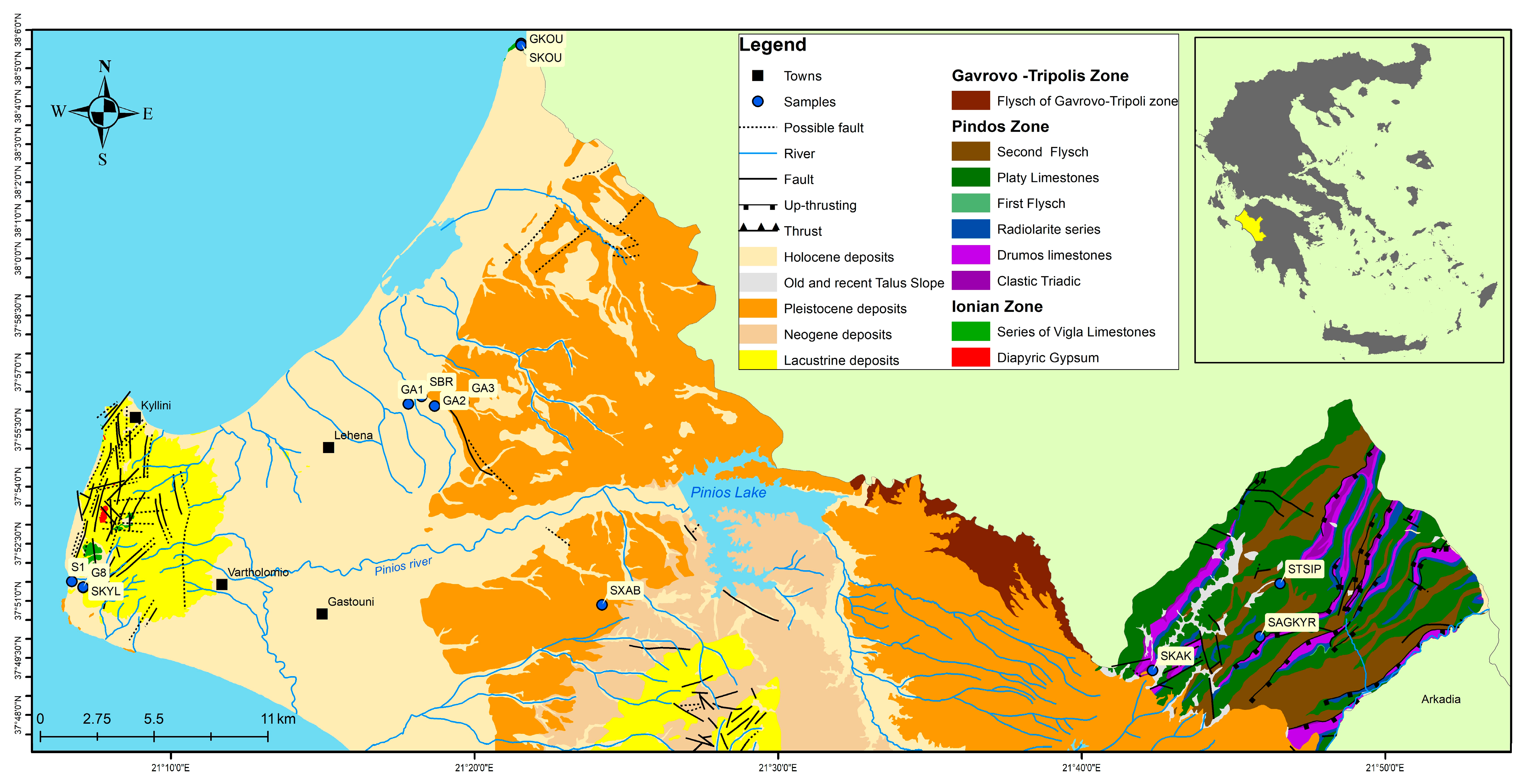
Figure 1. Geological map of the broader area.
Geosciences 14 00205 g001
Figure 2. Geological cross section of the broader area (modified by EAGME).
Geosciences 14 00205 g002
Figure 3. (a) Piper diagram and scatter plots of (b) Cl-Na, (c) Cl-Ca, (d) Cl-SO4, and (e) Cl-Mg/Ca. The black lines represent the concentration–dilution line of seawater.
Geosciences 14 00205 g003
Figure 4. (a) Shoeller diagram of samples. Fresh waters are depicted with blue and green color lines and thermo-mineral waters with red, pink, and maroon color lines and scatter plots; (b) B-Cl; (c) T(wa)-Li (T(wa) is temperature of water).
Geosciences 14 00205 g004
Figure 5. Radial diagram showing spatial trends in water composition (major anions and cations) of Kyllini Spring water in (a) 2009 and (b) 2020.
Geosciences 14 00205 g005
Figure 6. (a) Diagram of stable isotopes d18O (‰) and dD (‰) with Global Meteoric Water Line and Eastern Mediterranean Meteoric Water Line and (b) diagram of altitude (m) and d18O (‰) of water samples.
Geosciences 14 00205 g006
Figure 7. Frequency of saturation indices of (a) quartz, (b) calcite, (c) dolomite, and (d) barite.
Geosciences 14 00205 g007
Table 1. The physicochemical parameters, major ions, and trace elements of the water samples. The values of the major elements are given in mg/L, water temperature (Tw) in °C, Eh in mV, and electrical conductivity EC in μS/cm.
STSIPSAGKYRSKAKSXABGA2S1GA3LAKEGA1SBRSKYLG8SKOUGKOU
Tw12.415.112.218.117.418.320.328.722.226.224.526.22928.3
Eh69n.d.64671−26−34n.d.−42−48−26−37−9−11
pH7.697.387.847.327.047.427.588.187.787.577.387.586.886.93
EC347.1460.0264.1717.0796.01490.0763.0431.56720.02120.04175.04275.051,60047,400
CO2n.d.n.d.98n.d.1059391165263n.d.104178218168
HCO3185.4225.7189.1212.3211.6324.5340.4206.2559.9311.1612.4568.5381.9263.5
K+0.841.40.390.682.593.925.32.1614.465.9513.0813.32322322
Na+3.433.443.0518.1726.0684.6556.3011.28986.00168.80622.20636.209570.09870.0
Mg2+5.112.542.185.949.2821.524.57.1672.142.4535.2535.45780.50781.50
Ca2+64.0068.5058.0085.00119.50128.0066.5077.50119.50131.0062.0069.00852.00905.00
NH4+0.0930.0080.01400.0080.0421.8660.05913.2150.6852.3732.6063.4153.35
NO33.004.008.004.00127.001.005.004.004.402.4013.0018.005.2012.20
NO20.0190.0470.010.0090.0580.0030.0470.0550.01060.000.0020.0040.0590.172
SO42−12.1011.704.2034.70121.0077.3070.234.10790.00345.00277.00282.002560.02490.0
PO40.0340.0840.0940.2890.080.0610.0770.0270.7430.0720.2150.0770.0950.06
SiO27.505.904.7018.2020.5015.4016.402.0013.2016.8017.1015.7013.1013.10
F0.240.060.050.080.160.190.35 1.250.741.371.322.361.73
Cl3.31.83.236.024.4182.029.216.01260.0244.0710.0790.018,20018,460
B (*)18.014.416.317.928.3175.4152.233.42115.0522.81805.91996.63143.03095.1
Ba (*)11.3125.727.430.111.859.140.733.6105.078.769.056.357.765.1
Fe (*)74.084.072.6110.199.3168.599.393.1486.1176.2237.3244.00.00.0
Mn (*)0.90.40.4551.90.269.2182.736.214.4220.313.110.5378.4363.2
Li (*)1.92.31.47.27.68.59.14.188.026.952.054.7325.9317.5
Sr (*)81.0261.1123.3320.7354.5773.5573.5244.43610.91377.42002.52110.411,32111,232
* Values given in μg/L; n.d.: not detected.
Table 2. Descriptive statistics (max, min, average, and standard deviation) of the physicochemical parameters and major ions in Kyllini Spring. The values of the major elements and CO2 are given in mg/L, water temperature (Tw) in °C, and EC in μS/cm.
MinMaxAverageStDev
S2 *19,20033,10025,8403813.19
Ph7.187.447.2670.08
Tw24.128.726.191.38
EC386944954245.9220.05
CO298.4395213.04112.93
Alk480680558.370.19
HCO3585.6829.6681.12685.63
NH4+7.8259.858.4850.62
NO3152.61.51
NO20.0080.0870.02950.02
SO42177262219.526.38
PO420.041.630.5710.46
Cl−890110096878.29
K+14.114.5514.3250.16
Na+82090086029.81
Mg2+16.341.429.87.60
Ca2+56100.474.1213.48
* values given in μg/L; n = 10
Disclaimer/Publisher’s Note: The statements, opinions and data contained in all publications are solely those of the individual author(s) and contributor(s) and not of MDPI and/or the editor(s). MDPI and/or the editor(s) disclaim responsibility for any injury to people or property resulting from any ideas, methods, instructions or products referred to in the content.