Article

Morphology, Internal Architecture, Facies Model, and Emplacement Mechanisms of Lava Flows from the Central Atlantic Magmatic Province (CAMP) of the Hartford and Deerfield Basins (USA)

by
Abdelhak Moumou
1,*,
Nasrrddine Youbi
2,3,4,
Hind El Hachimi
5,
Khalil El Kadiri
1,
José Madeira
3,
João Mata
3,
Isma Amri
1 and
Abdelkarim Ait Baha
1
1
Environmental Geology and Natural Resources Lab, FS, Abdelmalek Essaadi University, Tetouan 2117, Morocco
2
Department of Geology, Faculty of Sciences-Semlalia, Cadi Ayyad University, P.O. Box 239, Marrakech 40000, Morocco
3
Instituto Dom Luiz, Faculdade de Ciências, Universidade de Lisboa, 1749-016 Lisboa, Portugal
4
Faculty of Geology and Geography, Tomsk State University, Tomsk 634050, Russia
5
Department of Geology, Faculty of Sciences, Chouaib Doukkali University, El Jadida 24000, Morocco
*
Author to whom correspondence should be addressed.
Geosciences 2024, 14(8), 204; https://doi.org/10.3390/geosciences14080204
Submission received: 5 June 2024 / Revised: 11 July 2024 / Accepted: 15 July 2024 / Published: 31 July 2024

Abstract

:
The morphology, internal architecture, and emplacement mechanisms of the Central Atlantic Magmatic Province (CAMP) lava flows of the Hartford and Deerfield basins (USA) are presented. The Talcott, Holyoke, and Hampden formations within the Hartford basin constitute distinct basaltic units, each exhibiting chemical, mineralogical, and structural differences corresponding to flow fields. Each flow field was the result of several sustained eruptions that produced both inflated pahoehoe flows and subaquatic extrusions: 1–5 eruptions in the Talcott formation and 1–2 in Holyoke and Hampden basalts, where simple flows are dominant. The Deerfield basin displays the Deerfield basalt unit, characterized by pillow lavas and sheet lobes, aligning chemically and mineralogically with the Holyoke basalt unit. Overall, the studied flow fields are composed of thick, simple pahoehoe flows that display the entire range of pahoehoe morphology, including inflated lobes. The three-partite structure of sheet lobes, vertical distribution of vesicles, and segregation structures are typical. The characteristics of the volcanic pile suggest slow emplacement during sustained eruptive episodes and are compatible with a continental basaltic succession facies model. The studied CAMP basalts of the eastern United States are correlated with the well-exposed examples on both sides of the Atlantic Ocean (Canada, Portugal, and Morocco).

1. Introduction

The Central Atlantic Magmatic Province (CAMP) is one of the largest Large Igneous Provinces on Earth. It was emplaced at ca. 201 Ma, close to the Triassic–Jurassic boundary, during the early stages of the breakup of the supercontinent of Pangaea that led to the opening of the Central Atlantic Ocean [1,2,3,4,5]. CAMP magmatism is nowadays represented by remnants of intrusive (crustal underplates, layered intrusions, sills, dykes) and extrusive (pyroclastic sequences and lava flows) rocks that occur in once-contiguous parts of North and South America, northwestern Africa, and southwestern Europe, e.g., [4,6,7,8,9,10,11,12]. It may have covered over 7 × 10⁶ km2, with a total volume of magma estimated at 2–4 × 10⁶ km3, and it was active for no more than 4–5 Ma (2,3,4). However, the geographic boundaries of the CAMP remain uncertain, especially in Africa and South America. Recent investigation suggests that the CAMP was placed as far as the sub-Andean area in southern Bolivia, about 3000 km from the Atlantic margin [13]. This indicates that the extension of CAMP magmatism is probably much more extensive than previously recognized. Most CAMP rocks are tholeiitic low-Ti Continental Flood Basalts (CFBs) (3).
In contrast, high-Ti CFBs are restricted to a narrow zone in the southern margin of the West African craton (Liberia, Sierra Leone) and northeastern South America (Surinam, French Guyana, and northern Brazil), e.g., [14,15,16,17]. The CAMP is the result of a mantle super-plume, e.g., [18,19] or a consequence of lithosphere extension and thinning, pre-dating the Atlantic opening, that triggered decompressional melting in the upper asthenosphere e.g., [20]. Magmatism is coeval with the mass extinction at the Triassic–Jurassic boundary, e.g., [21]. Intrusive rocks are abundant and represented by up to 800 km long isolated dykes, dense dyke swarms, as well as by extremely voluminous sill complexes, and a few layered intrusions. Lava fields erupted as short-lived pulses and can be traced over distances of several hundred km within sedimentary basins [9,22,23,24]. The thickest lava flow sequences crop out in Morocco and North America (up to 500 m thick; [3,8,17,25], while the thinner lava piles are described from Algeria (10–15 m), Portugal (up to 30 m), and South America (up to 130–170 m; Figure 1) [13,16,26,27].
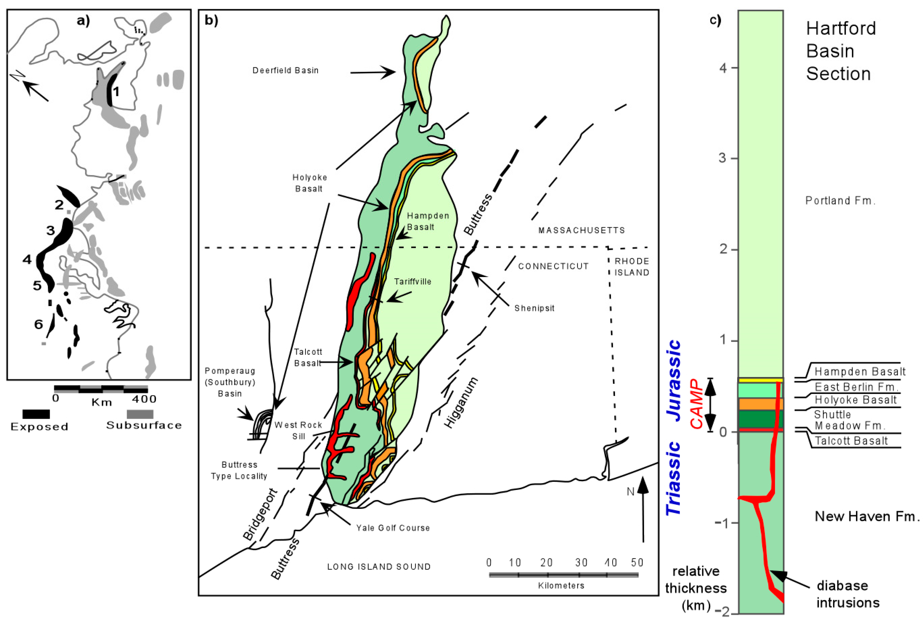
In the United States of America, the Newark Supergroup includes the lithologically and structurally related continental clastic rocks and interbedded CAMP basaltic flows of the Triassic–Jurassic age that are exposed in discrete elongated basins parallel to the Appalachian orogen in the Piedmont of eastern North America [29]. CAMP sequences are present in five basins and sub-basins, namely in the Hartford (Connecticut), Deerfield (Massachusetts), Gettysburg (Pennsylvania), Culpeper (Virginia), and Newark (New Jersey) basins. In the Hartford basin, the CAMP basalts crop out along three parallel ridges (Figure 2): Talcott Basalt, Hampden Basalt, and Holyoke Basalt [30]. However, in the Deerfield basin, the CAMP volcanic succession consists only of one basalt formation called Deerfield basalt.
Several studies have focused on the petrology and geochemistry of CAMP basaltic rocks of the USA to classify and elucidate the petrogenesis, the different mechanisms for supercontinent Pangaea breakup, and the formation of Large Igneous Provinces ([31,32,33] and references therein). Hitherto, comparatively little attention has been paid to the physical volcanology of the USA CAMP except for some seminal contributions that paved the way for this work [34,35,36,37,38,39,40,41,42]. However, it is worth studying the morphology and internal structures to decipher the emplacement mechanisms and the time–space distribution of the successive basaltic episodes of the CAMP and establish model facies.
The detailed field analysis of the basaltic formations of Hartford and Deerfield allowed us to describe the morphology and internal structures to deduce lava flow emplacement processes and the genesis of associated structures. Correlation and comparison with other basins in the United States (Newark basin), as well as with the Canadian Fundy basin [25], Portuguese Algarve and Santiago do Cacém basins [26], and Moroccan High Atlas [43,44] will be presented. These are expected to allow the proposal of a general facies model of CAMP flows and Continental Flood Basalts. Based on our observations and previous works, some suggestions about the Triassic–Jurassic boundary will be inferred.

2. Geological Setting

The Hartford (Connecticut), Deerfield (Massachusetts), and related early Mesozoic continental rift basins that are preserved on the margins of the Atlantic-bordering continents were formed during the incipient breakup of Pangea in the Triassic (Figure 2a). The overall structure of the Hartford basin (Figure 2b) is consistent with a step-faulted half-graben geometry as seen in other Newark Supergroup basins ([23,24,25,26,27,28,29,30,31,32,33,34,35,36,37,38,39,40,41,42,43,44,45] and references therein). The Hartford basin runs nearly north–south with a segmented west dipping border fault system on its eastern side, toward which the basin strata tilt at predominately low to moderate (∼10–15°) dips. The border fault system generally parallels the structural fabric of the Paleozoic metamorphic basement, suggesting that the border faults may be reactivated structures [46].
The large-scale lithostratigraphy of the basin fill is composed of a tripartite succession (Figure 2c): (i) a lower coarse arkose unit up to 3000 m thick named the New Haven Formation; (ii) a middle, generally finer-grained 2500 m thick sequence containing interbedded basalt flows of the CAMP near its base, which consist of the Talcott Basalt, Shuttle Meadow Formation, Holyoke Basalt, East Berlin Formation, Hampden Basalt, and about the lower Portland Formation; and (iii) an upper coarse arkose unit that exceeds 1500 m in thickness comprising the Portland Formation. A Jurassic middle and upper succession age is based on palynology [47,48,49] and vertebrate biostratigraphy [50,51]. Radio-isotopic dates from the CAMP basaltic flows interbedded with these strata have substantial scatter attributed in large part to post cooling alteration but are not inconsistent with a Jurassic age [52,53]. Geochemical and cyclostratigraphic correlation with other basins that have igneous rocks with more secure radio-isotopic dates [53,54,55,56] supports the earliest Jurassic (∼200 Ma) age for the basalts [7]. Mafic sills (e.g., Barndoor, West Rock, East Rock, Carmel) and dikes (e.g., Buttress, Higganum) intrude the New Haven Formation but not the Portland Formation and are considered as feeders of the extrusive volcanic [57]. The Deerfield basin is connected to the Hartford basin and has an analogous stratigraphy, except that only one basalt unit (Deerfield Basalt, equivalent to the Holyoke Basalt) [58,59,60] is present.

3. Terminology and Methods

Based on their surface morphology and structure, basaltic lava flows were subdivided into pillow, pahoehoe, and ‘A’ā flows, e.g., [61,62,63]. Pahoehoe flows are characterized by a smooth, billowy, or ropy surface and exhibit a typical three-tiered structure [64], comprising: (i) a basal lava crust; (ii) a lava core; and (iii) an upper lava crust. ‘A’ā flows are characterized by a massive or prismatically jointed core enveloped by angular clinker at both the top and base. A wide range of intermediate flow types occurs between these two end-member types, such as rubbly pahoehoe and slab pahoehoe [61,62,65,66,67]. Moreover, an important basalt structural type known as toothpaste lava, which illustrates the transition from pahoehoe to ‘A’ā, is particularly well displayed in the 1960 Kapoho lava flow of Kilauea Volcano [67]. According to Self et al. [68,69] and Thordarson and Self [70], the products of an effusive eruption can be subdivided into three hierarchic levels: flow lobes, lava flows, and lava flow fields. (i) A flow lobe is an individual unit of lava enclosed in a chilled crust, varying in length from decimeters to several kilometers and up to tens of meters in thickness [71]. Lobes can be classified into two types: S-type (“spongy”) lobes, vesicular throughout their thickness and lacking pipe vesicles, and P-type lobes (“pipe amygdale-bearing”), characterized by pipe vesicles and a vesicular base and top [71]. (ii) A lava flow is a regional subunit formed during a continuous effusive event. If a lava flow consists of a single flow lobe, it is referred to as a simple lava flow; if the lobe has a sheet-like or tabular geometry, it is classified as a sheet lobe; if the lava flow is composed of multiple lobes, it is termed compound lava flow [72]. (iii) A lava flow field is a complex body consisting of several lava flows produced by a single eruption. This work uses the terminology for inflated pahoehoe flows proposed in [68,69,70] (Figure 3). The three following aspects are considered diagnostic features for pahoehoe inflation: (a) distribution, mode, shape, and size of vesicles, and vesiculation pattern; (b) jointing style; and (c) petrographic texture. This method has been applied to the Laki eruption flows (1783–1784) in Iceland [73] and to various CAMP basalt flow sequences [25,41,42,43,44,74,75,76,77,78,79,80,81,82,83].
For the estimation of the emplacement duration of pahoehoe lava flows, we use the empirical cooling model in Hon et al. [84], where the flowing equation t = 164.8 H2 allows us to estimate the time required for a lava flow crust to grow (where t is the time of emplacement in hours and H is the thickness of the upper crust in meters). While this technique may slightly underestimate the emplacement duration of an inflated lobe, it is the only quantitative method of estimating the duration of active emplacement of ancient lava flows currently available [68,85]. In the subaquatic lavas, pillows were measured for morphometric analysis. The horizontal (H) and vertical (V) maximum diameters of 105 pillows were measured using the method proposed by Walker [85]. We also use the terminology proposed by Fisher [86,87] to describe volcaniclastic (e.g., peperite, hyaloclastite) and epiclastic rocks (e.g., mudstone, siltstone, sandstone, limestone) that other authors have used for the description of primary volcaniclastic deposits, e.g., [88,89]. This classification [86,87] subdivides volcaniclastic rocks into pyroclastic, hyaloclastic, autoclastic, and epiclastic based on the particle-forming processes. Pyroclastic fragments (produced by explosive fragmentation), hyaloclastic (quench fragmentation), and autoclastic (mechanical self-fragmentation) can be applied to both individual grains and their deposits [90]. The epiclastic classification is restricted to fragments derived from weathering and erosion of pre-existing rocks.

4. Results

Several sections were investigated from south to north across the basaltic formations cropping out in the Hartford and Deerfield basins in Connecticut and Massachusetts (Figure 2a,b). Three principal basaltic formations occur in northern Connecticut. From oldest to youngest, these are referred to today as the Talcott, Holyoke, and Hampden basalts. Although all are basalts, they are individually distinct and differ from one another chemically, mineralogically, and structurally [31,57,91]. We will describe in detail some of the best-preserved outcrops of the three basaltic formations (Talcott, Holyoke, and Hampden Basalts) within the Hartford basin. In the Deerfield basin, a single basalt Formation is present: the Deerfield Basalt, which is chemically equivalent to the Holyoke Basalt [60,92].

5. Field Observations

5.1. The Talcott Basalt Formation

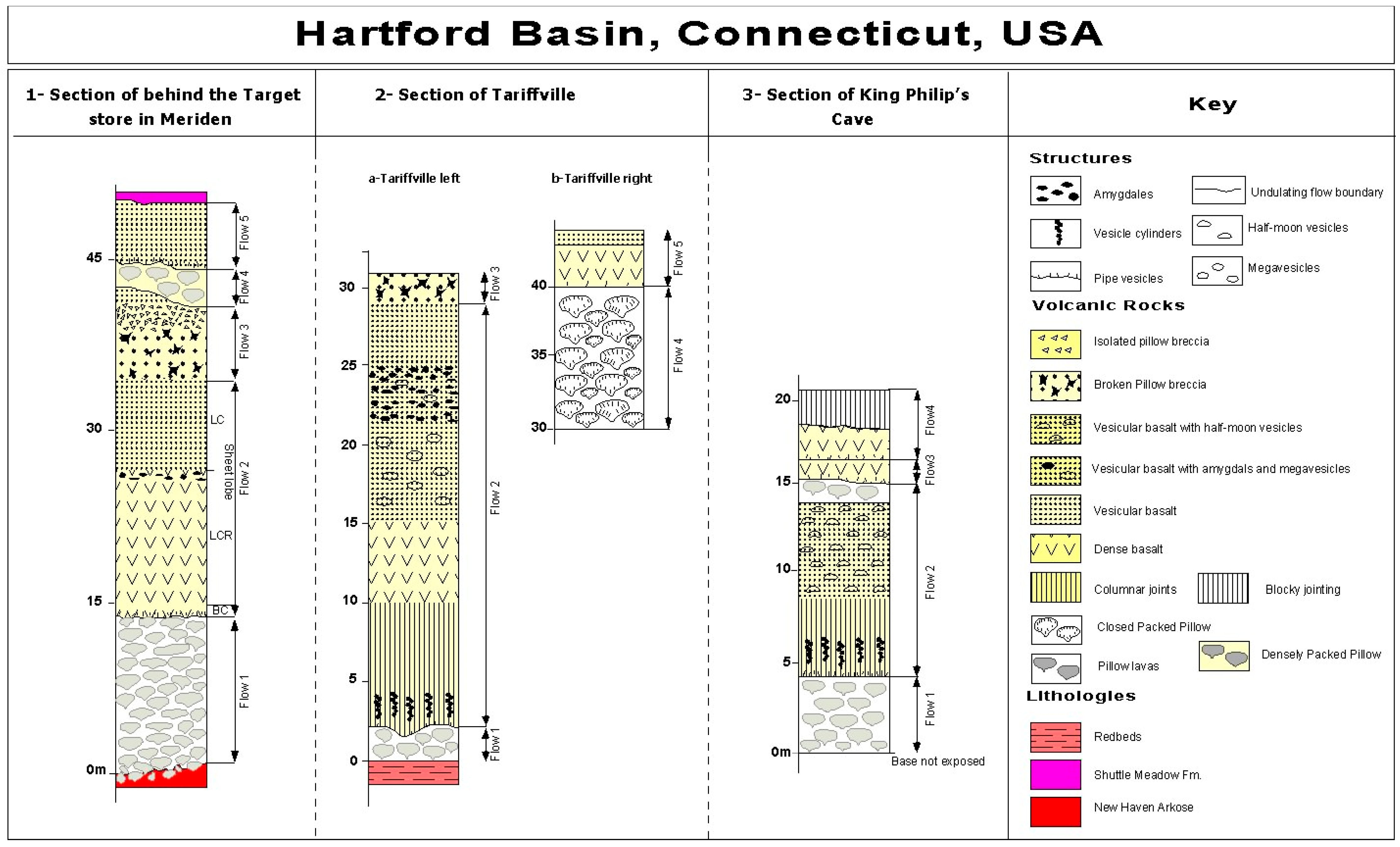
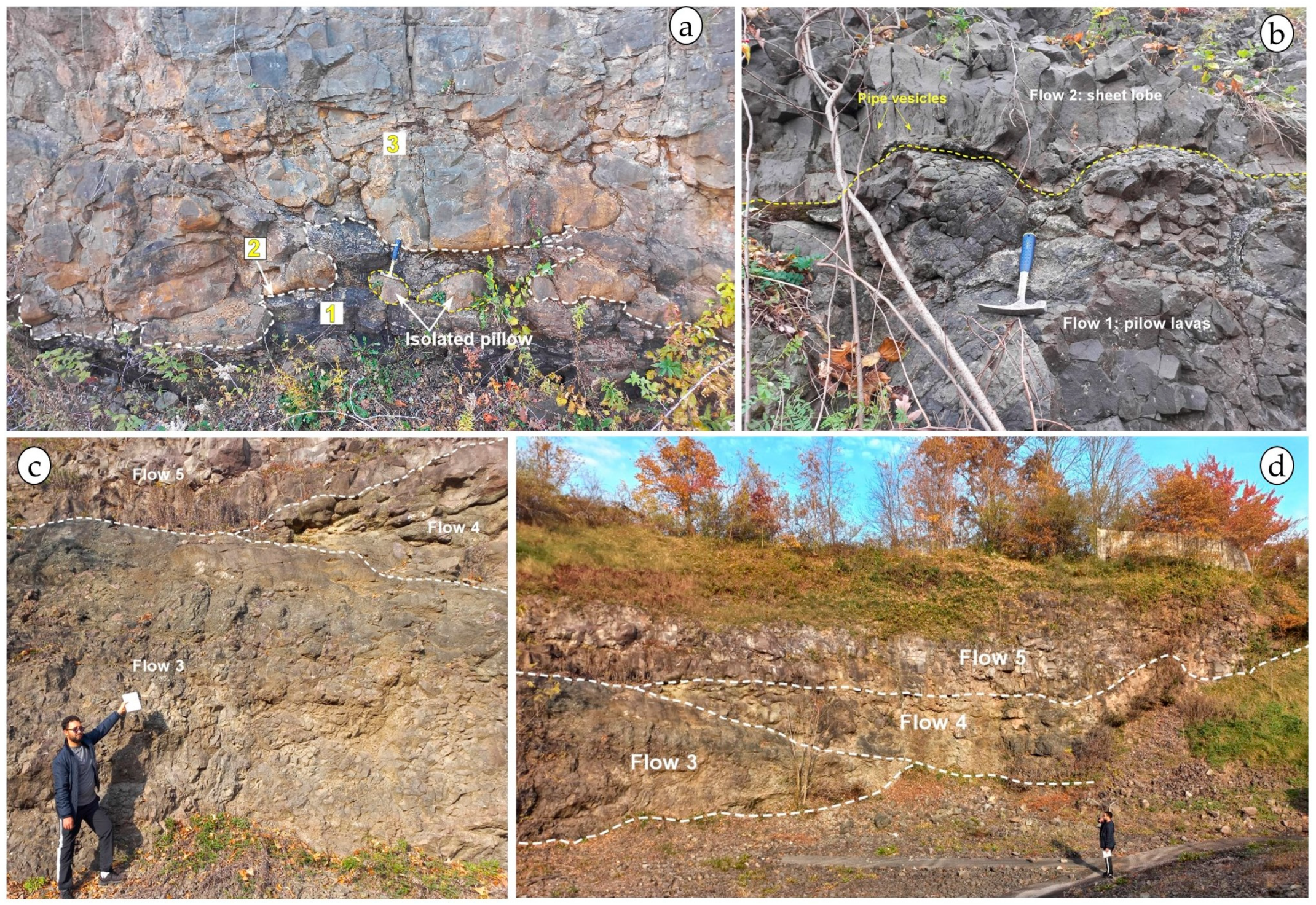
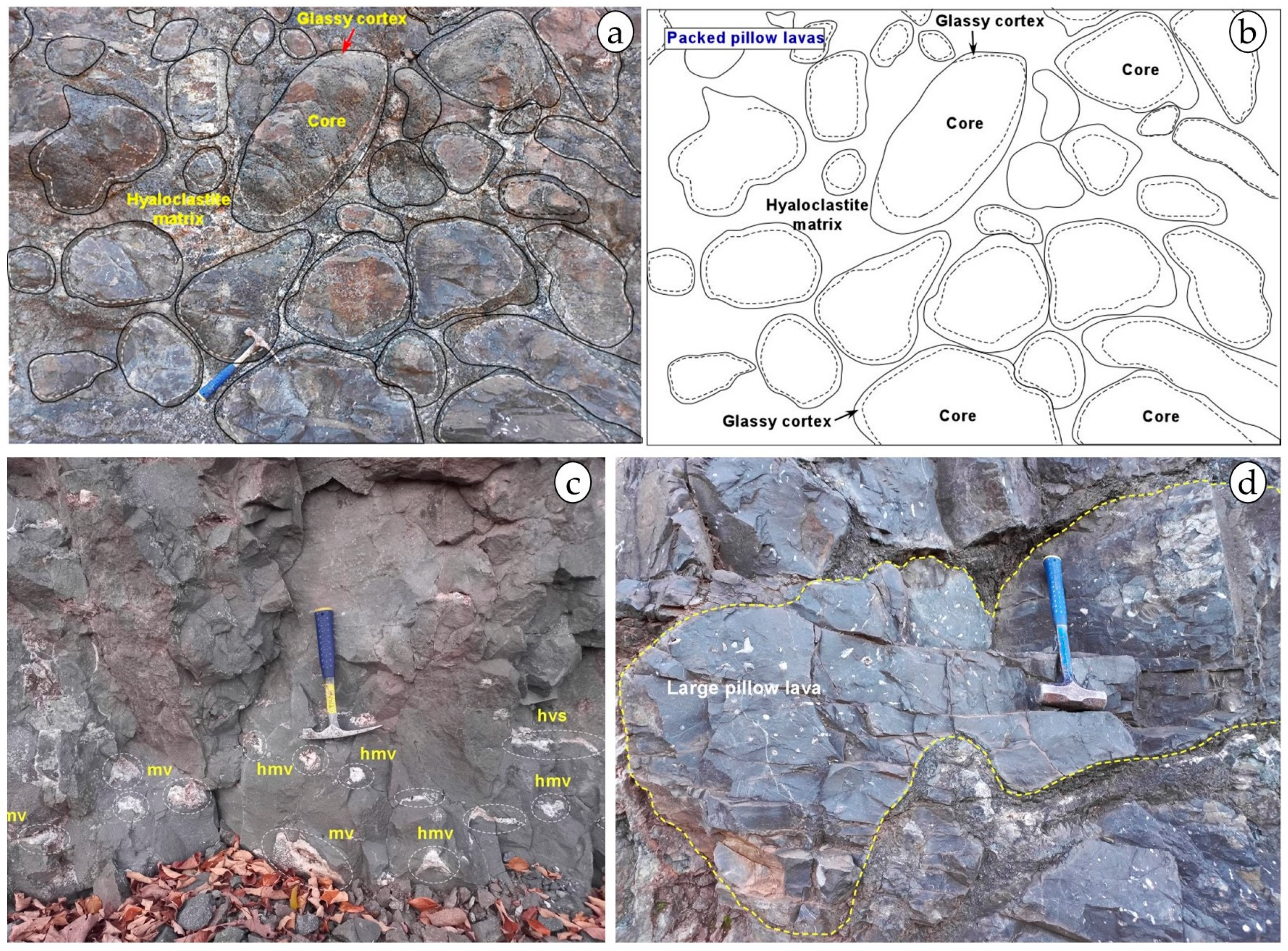
The Talcott Basalt Formation is the oldest of the three flood basalts in the Hartford basin and can be traced over 50 km (Figure 2a,b). This flow is locally composed of pillow lava. One of the best and most accessible outcrops of this formation is the extended cut at parking behind the Target store in Meriden, Connecticut (coordinates N 41°33′9.34″, W 72°49′0.40″, WGS 84). The 50 m thick volcanic sequence comprises five basaltic lava flow units (Figure 4 and Figure 5): unit 1 is composed of ~15 m of closely packed large pillow lavas passing upwards to smaller pillows within a hyaloclastite matrix (Figure 5a–c and Figure S1).
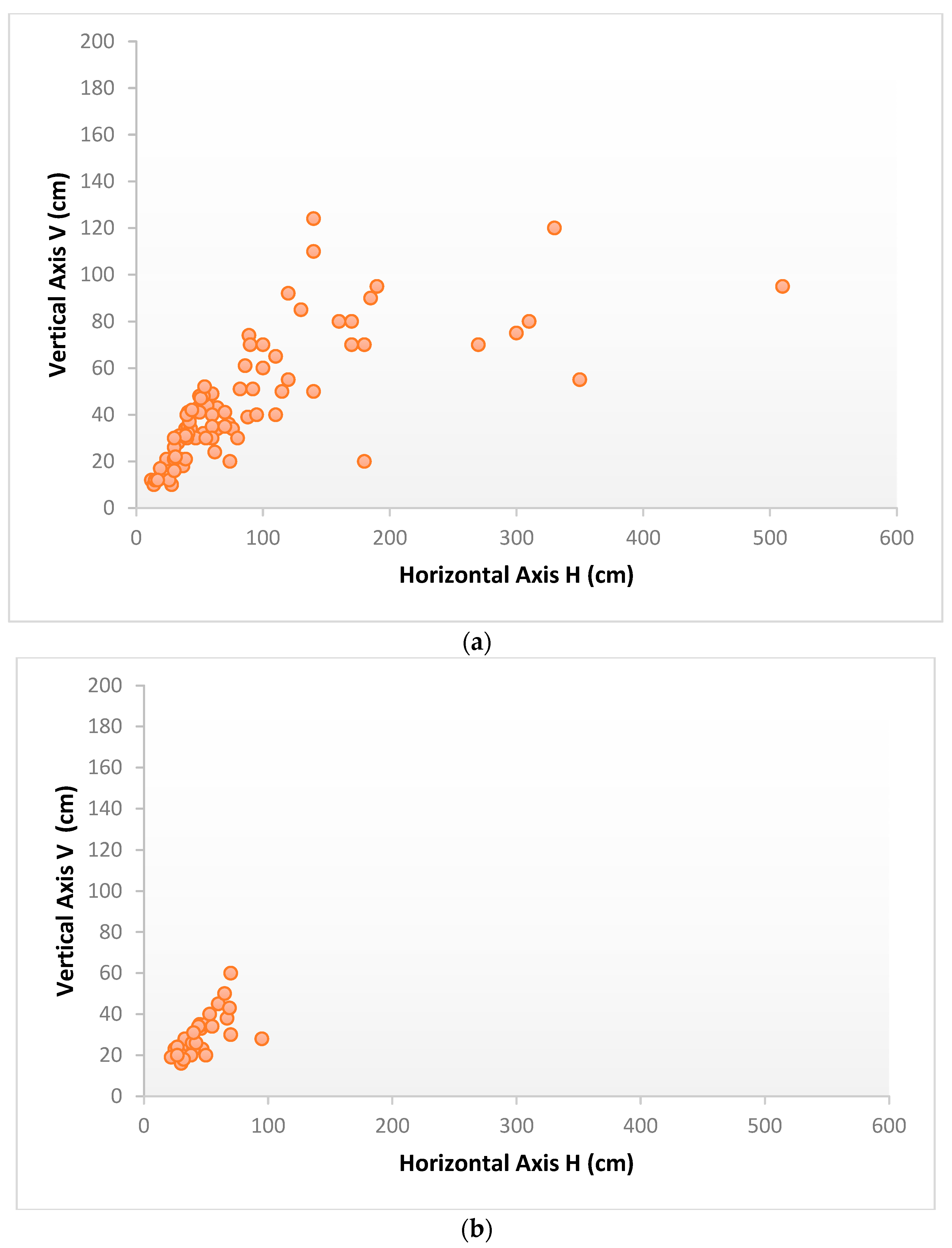
The H and V axes of the pillows range from 12 × 12 cm in diameter up to 510 × 90 cm, respectively (Figure 6).
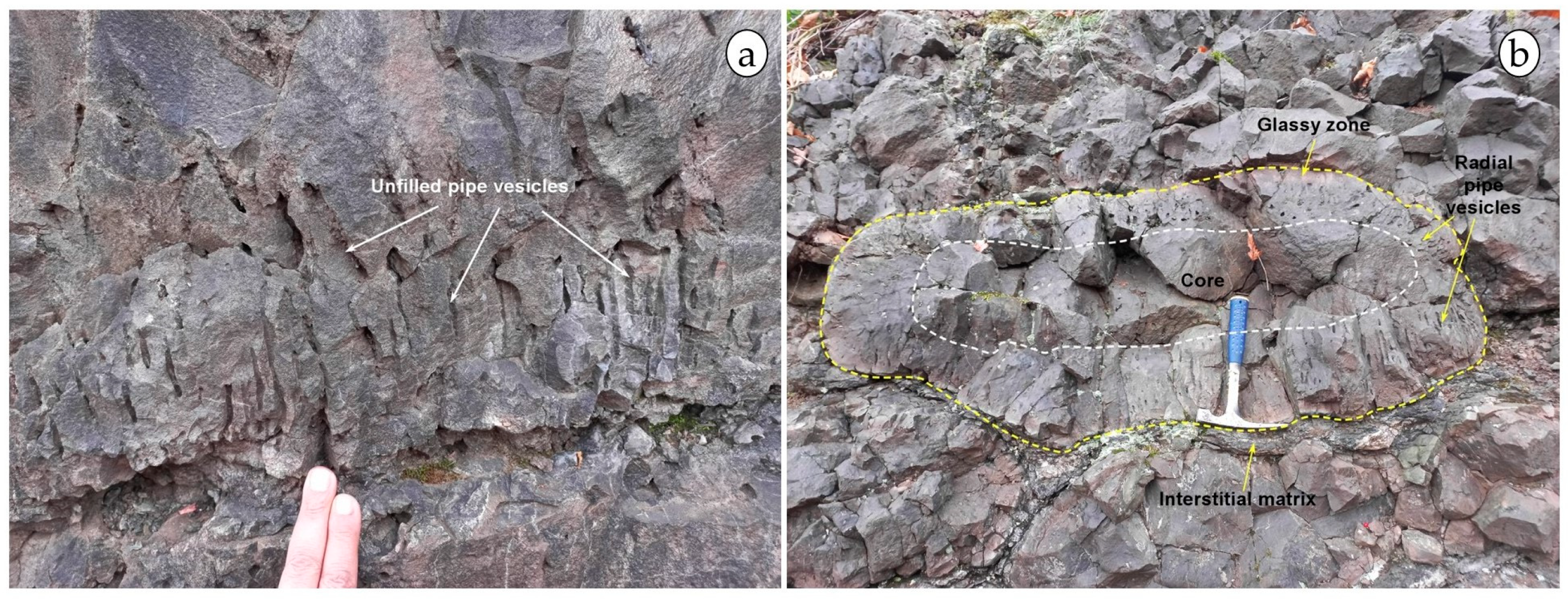
The pillow lavas are flat to circular shapes in cross-section (Figure 6, Figure 7b, Figure 8a,b,d and Figure S1; Table S1). The internal structure of the pillows is characterized by a 0.2 to 15 cm thick outer glassy cortex surrounding the core. Moreover, the duplication forms with digitation are formed on the pillows (Figure 8d).
Generally, the pillows present radial pipe vesicles (Figure 7b). (i) The lowermost pillows are intruded into the black mudstones of the underlying New Haven Formation, locally displaying rare, isolated pillow, and load cast structures (Figure 5a). (ii) Unit 2 is a 22 m thick subaerial sheet lobe displaying the typical three-tiered structure of inflated pahoehoe: a thin basal crust (0.20–0.30 m) with pipe vesicles (Figure 7a), a massive lava core (13–14 m), and a vesiculated upper lava crust (8 m) (Figure 4 and Figure 5b–d). (iii) Unit 3 is composed of 2 m of pillow breccias overlain by a 1 m thick horizon of well-preserved isolated pillow or fragmented pillows in an abundant hyaloclastite matrix passing into a thin (<1 m) vesicular flow (Figure 5c,d). (iv) Unit flow four is composed of a 4 to 5 m thick sequence of densely packed pillows emplaced in paleochannel (Figure 5d). (v) The uppermost unit 5 is a 7–8 m thick subaerial vesicular lava flow with pipe vesicles at the bottom.
Vesicularity is always higher in the upper crust than in the lava core of unit 2. Mega-vesicles (Figure 8c) and horizontal vesicular sheets are present at the top of the lava core. Vesicle cylinders (vertical pipes filled with bubbles and residual melt that differentiate from diktytaxitic basalt flows during crystallization) are absent behind the Target store outcrop, but occur at Hubbard Park outcrop (also at Meriden: N 41°33′12.42″; W 72°49′41.34″) where they reach 40 cm in length (Figure S2), and also at Tariffville (N 41°54′28.73″; W 72°45′40.18″). Pipe vesicles are usually observed at the sole of sheet lobes. The paleo-flow direction of the subaquatic lava flows can be deduced from the main direction of the axes of the pillow lava axis; also, the pipe vesicles are tilted towards the dip direction of the pillows [94]. In the first pillowed flow (unit 1) of Behind the Target store in the Meriden section the mean direction of the axes of the pillows is N 10° E–S l0° W after removing the tectonic tilt.
On the road 80 from New Haven to the Tilcon quarry near North Branford Town (3 km before the Tilcon quarry: N 41°19′28.48″; W 72°49′33.50″), there is a 0.6 m thick neptunian dyke (attitude N 10–20, 75–80 E) with chilled margin, with a peperitic fill of arkosic sediment and lava (Figure 9a–c). The peperitic lava particles are both fluidal and blocky (Figure 9a–c) in the Neptunian dyke; that is to say, fluidal and blocky juvenile clasts mingling and superpose in the same area. The Talcott Basalt Formation, found in Meriden, Connecticut, features well-developed layers of blackish spherules, possibly accretionary lapilli, located a few centimeters below its first pillowed flow (Figure 9e,f).

5.2. The Holyoke Basalt Formation

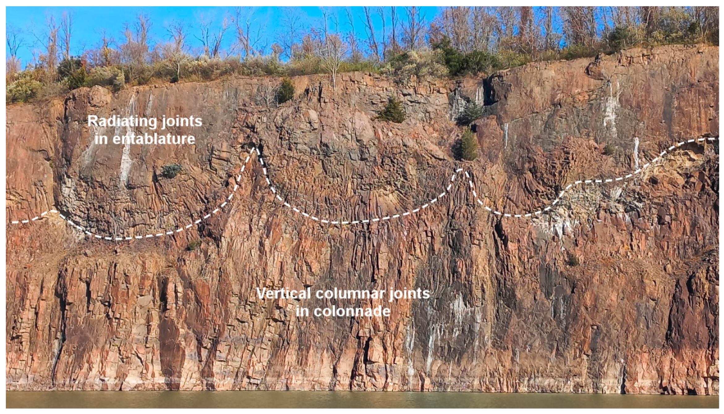
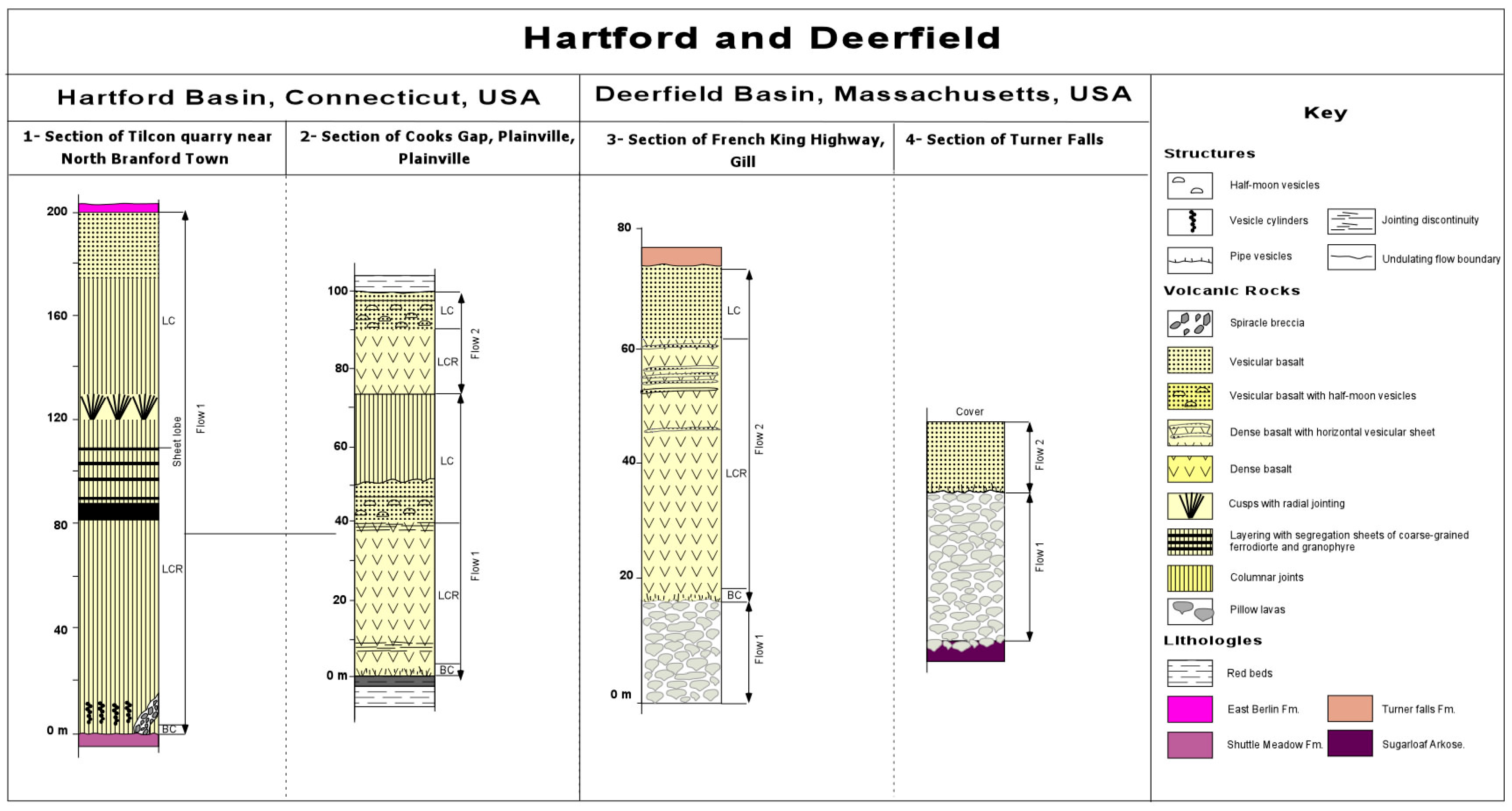
The Holyoke basalt formation is 50 to 200 m thick. The Holyoke basalt can be traced almost continuously in a north–south direction for 160 km, but its east–west extent is uncertain, and it must have been at least 50 km. In the Tilcon quarry near North Branford Town (N 41°20′31.81″; W 72°47′39.28″), the Holyoke basalt is very thick, around 200 m, and the unit tends to be thicker towards the north (Figure 10, Figure 11 and Figures S3–S5).
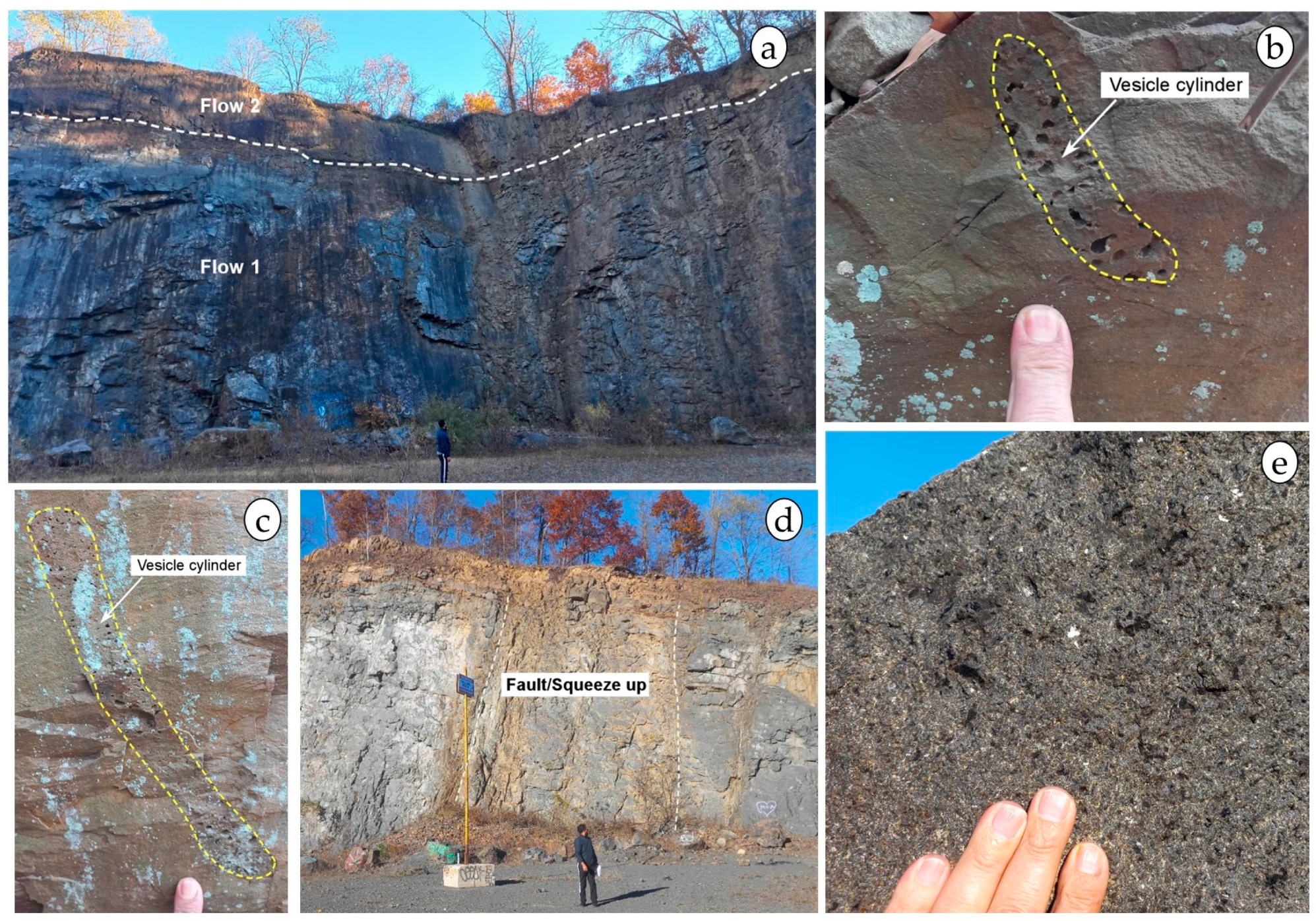
However, there is a second, thinner flow near Hartford town. Except for its vesicular upper surface, the Holyoke flow is essentially massive. In contrast to the Talcott Basalt, its lower contact with the Shuttle Meadow Formation is sharp and relatively featureless. The basal crust is 20 to 40 cm thick and fine-grained in texture. It does not show any pipe vesicles. Vesicle cylinders develop here as segregation structures like those frequently observed in the core of pahoehoe flows. These forms are located at the base of the first flow, occurring around 40 to 45 cm above the base of the flow (Figure 12b,c).
The section of Holyoke Basalt exposed in the Tariffville Gorge is 174 m thick. The flow is underlain and overlain by lacustrine sediments, many containing salt casts. The flow can be divided into upper and lower parts based on jointing style. The upper part is characterized by irregularly oriented joints, which give the outcrop a blocky appearance, whereas the lower part is characterized by vertical slender prismatic jointing. In places, colonnade-type joints with horizontal striations are present in the lower part of the flow, but most of these columns appear to have broken into vertical splinter-like joints.
The boundary between the upper and lower parts of the flow in the Tariffville section occurs 97 m above the base, which is 55% of the way up through the flow. In contrast, the boundary between colonnade and entablature style jointing in most thick flows is ~20–40% of the height of the flow [95,96]. The surface of the flow was weathered before being buried beneath sediments. No erosion occurred, however, as indicated by the preservation of flow-top features, such as scoria, rafted crustal slabs, and even ropy structures. Layering with liquid segregating to form sheets of coarse-grained ferro diorite occurs from about 70 to 85 m above the base of the flow. Most segregation sheets are a few decimeters thick, but the lowermost at this locality is 2 m thick (Figure 12e). In contrast, segregation sheets are absent where the flow is thinner and homogeneous throughout [97,98]. The Holyoke basalt formation is interpreted as a huge lava lake extending from North of Brantford in the Hartford basin (Connecticut) to the north in the Deerfield basin (Massachusetts) and to the west in the Pomperaug basin (Connecticut) [40]. In the Tom Holyoke Mountains, Massachusetts, the Holyoke basalt is composed of at least two flows (Figure 12a). Here, lava flows are dense and without vesicles. The thickness of the first lobe is about 60–80 m, and the second lobe is 15–20 m. The first flow is affected by two faults: trending N 30–40, 75–85 SW, and N 10, 85 W. The faults are filled with fine-grained homogeneous basalt and are sealed by the second thin flow (Figure 12a and Figure S6). A complete Lower Holyoke flow is exposed in abandoned quarries on the north side of Cooks Gap (Plainville: N 41°40′28.72″; W 72°49′44.95″). The contact with underlying Shuttle Meadow sediments crops out in the small quarry 600 m to the west of the main one. Contact metamorphism includes the bleaching of the ordinarily red sediments and the development of steam vesicles in the shales as much as 2 m below the flow. Although both flows can be traced to Farmington, only the upper flow is present further north. In Cooks Gap, both flows are about 50 m thick, have a zone of half-moon vesicles near their tops, and have a vesicular upper surface. The nature and intensity of jointing in the two flows is one of the few ways of distinguishing them in the field. The younger flow characteristically breaks along slightly curved near vertical joints into decimeter-sized splinter-like columns. The lower flow is much less fractured and generally presents a meter-thick slab jointing parallel to its base. The character of the jointing is not completely uniform through either flow. The horizontal discontinuity in the fracture pattern 10 m below the top of the lower flow at Cooks Gap is particularly noteworthy as it may record the thickness of the upper crust when the second flow erupted. The vesicular upper surface of the first flow is irregular with local relief on the order of a meter or more. Although reddened, the surface suffered little erosion before the eruption of the second flow. Depressions and fissures, which one might have expected weathered detritus to accumulate, are filled by younger basalt (Figure 12d). The base of the upper flow is extremely fine-grained and massive. Vesicles are rare, but xenoliths of the vesicular crust of the underlying flow are not uncommon. South of Farmington, the Holyoke Basalt Formation consists of two massive 50 m thick flows. Only the top few meters of each are vesicular. The lower flow thins out just north of Farmington, and only the upper flow is present in northern Connecticut.

5.3. The Hampden Basalt Formation

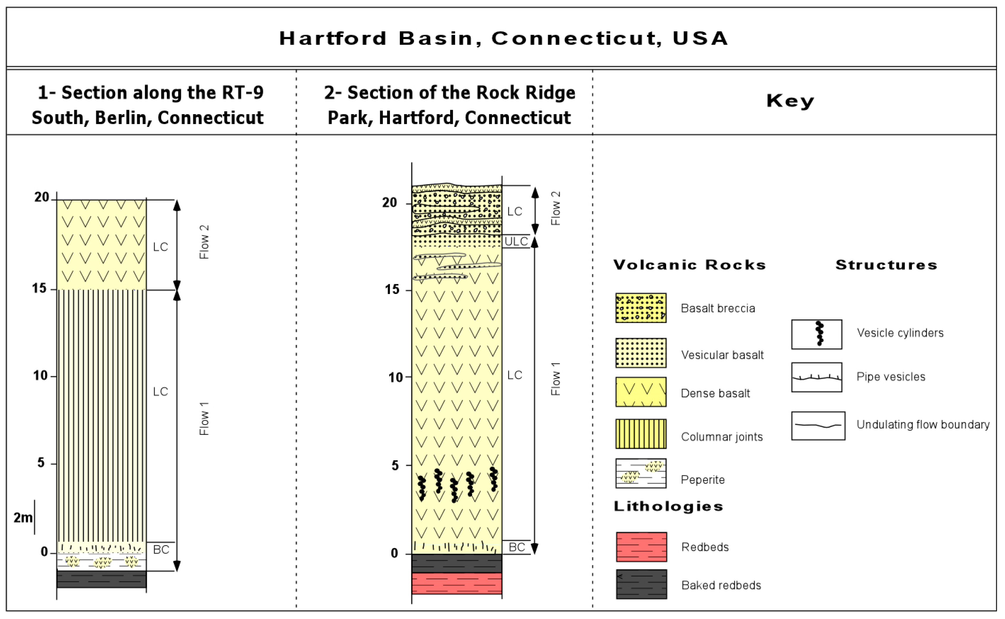
The Hampden Basalt is the thinnest extrusive unit in the Hartford basin. It is typically massive and ranges in thickness from about 20 to 30 m (Figure 13). It occurs between the East Berlin and Portland formations. At Berlin, the contact between the Hampden basalt and the East Berlin sediments is well exposed along the route RT-9 South (Figure 13).
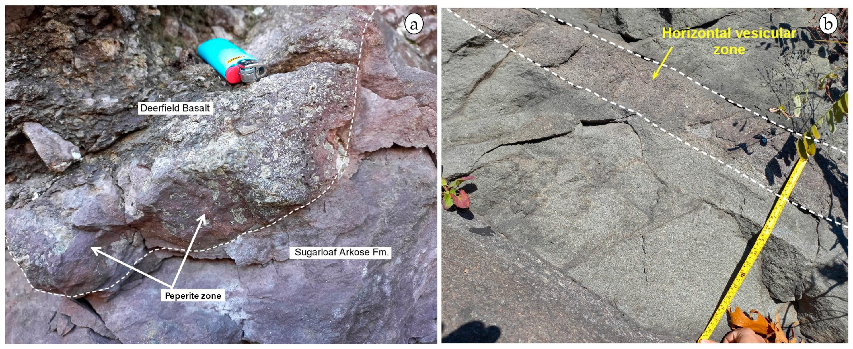
Tilted pipe vesicles are present in almost every exposure of its lower contact and generally indicate a northeasterly flow advance (Figure 11c,d and Figures S7 and S8). The contact basalt–sediment is marked by “injections” of basalt into the underlying sediment, creating a peperite facies (Figure 4d and Figure 9d). Two eruptions formed the Hampden basalt. The lower flow is 15 m thick in the Berlin section, and the upper flow is 5 m thick. Segregation structures characteristic of pahoehoe flows, such as pipe vesicles, are present, while cylinder vesicles and vesicular sheets are absent. In Rock Ridge Park, Hartford, the Hampden basalt consists of two flows (about 21 m thick) and presents a flow top breccia and a thin scoriaceous base. The presence of a base and top breccias indicate that it is an ‘A’ā flow (Figure 14f,g and Figure S9). Within a meter below the contact, the sediments have lost their fissility and red color. Calcite-filled steam vesicles are locally abundant in the baked sediments. Abundant elongated and tilted pipe vesicles occur at the flow base. Near vertical vesicle cylinders, 3–4 cm in diameter and 1–2 m in length are standard 2 m above the base. Horizontal vesicular sheets are common in the upper part of the lava core (Figure 14a,b). A 2-m thick sequence of 10–30 cm thick sheets of both vesicular and massive basalt interbedded with a breccia containing angular basalt fragments set in a fine-grained basalt matrix overlies the vesicular top of the second flow (Figure 14e–g). An outcrop of this peculiar breccia is located on the east side of Summit Street just north of Vernon Street.

5.4. The Deerfield Basalt Formation

The Deerfield basin (Massachusetts) is the northernmost exposure of the Newark Supergroup (Figure 2). The Deerfield basalts are the only basalt unit in this basin (Figure 11) and are intercalated between the Triassic Sugarloaf Arkose and the Jurassic Turners Falls Sandstone [35]. The 75 m thick Deerfield Basalt Formation comprises two flows (Figure 11). The lower unit 1 is a pillow lava sequence overlying arkose sediment from the Fall River beds of the Sugarloaf Arkose (Figure 11 and Figure 15a).
Pillows injected into and folding the sediment and the development of peperites (Figure 15a and Figures S10 and S11) indicate that the sediment was unconsolidated, and the pillows flowed eastward. Unit 1 is superposed by a subaerial sheet lobe presenting pipe vesicles at its base (Figure 11). Horizontal vesicular sheets are common in the upper part of the sheet lobe, and the top of the lobe is vesicular (Figure 11, Figure 15b and Figure S12). However, cylinder vesicles, mega-vesicles, and amygdales were not observed. In Gill, the Deerfield basalt is also composed of a subaquatic lava flow covered by one or two subaerial sheet lobes. Unit 1 is 30 m thick, and the pillows present pipe vesicles, although less abundant than in the Talcott basalts. Unit 2 is composed of two dense lava lobes 15 m and 20 m, respectively (Figure 11). Unfortunately, the accessibility of the vertical road cut does not allow direct observations of sheet lobes. At another outcrop (near the Greenfield bridge), the Deerfield basalt starts with 15 m of pillow lavas overlain by a 30 m thick sheet lobe. The upper part of the sheet lobe core presents five horizontal vesicle sheets alternating with dense basalt and is followed by a six m thick vesicular lava crust. The contact between the pillow lava and the sheet lobe is undulated.

6. Discussion

6.1. Emplacement Conditions and Vent Locations of the Lava Flows from the Hartford and Deerfield Basins

The observed field characteristics suggest a volcanic sequence being emplaced in a tectonic basin occupied by temporary lakes where sandy sediment was deposited. The initial flows of the Talcott and Deerfield basalts correspond to pillow lavas, indicating a subaquatic and locally intra-sedimentary lava deposition. The following eruption of the Talcott formation formed a subaerial sheet lobe, indicating that the lake was no longer present. However, the pillow breccias and pillow lavas of units 3 and 4 indicate that the basin was again inundated.
The Holyoke basalt, the second volcanic formation, corresponds to one thick sheet lobe of a simple inflated pahoehoe flow. The Holyoke basalt has erupted under subaerial conditions after the deposition of the underlying 100–250 m thick sediments (of the Shuttle Meadow Formation [38]). These underlying sediments contain salt casts indicative of a Playa Lake environment before the Holyoke lava flows erupted. However, no pillow lavas are present, indicating that Holyoke lavas were placed in a subaerial environment.
During the youngest extrusive sequence, the Hampden basalt, the first flow is a sheet lobe deposited onto the soft sediments of East Berlin formation, indicating that the basin mainly was under subaerial conditions at that location. Based on different geochemistry, the three principal basaltic formations, Talcott, Holyoke, and Hampden basalts, correspond to three lava flow fields [17,98,99,100,101,102]. According to [57], the chemistry and mineralogy of the three northeasterly trending diabase dykes that cross Southern New England correlate with the three basaltic episodes of the Hartford basin. The three successive basaltic events were fed by the Higganum (eastern dyke), Butress-Ware (central dyke), and Bridgeport-Pelham (western dyke) dykes, respectively. The magmatic activity progressed, thus, westward with time. The Deerfield basalt is chemically correlative with the Holyoke Basalt. Still, the subaquatic nature of its unit 1 indicates that at the Deerfield basin, there was a lake at least 20 m deep, while the Hartford basin was dry at the time.
Neptunian or clastic dikes are locally quite common in CAMP flows. The possible reason is that peperitic processes undergo different mingling periods from plasticity to brittleness. Magma starts to quench after the steam episode, while a viscosity increment of fluidal magma happens during the cooling process. It results in magma behavior turning into brittleness. The peperite (blocky/fluidal peperites and mixed blocky) are located stratigraphically above the main feeder and appear to be confined to a horizon immediately below an amygdaloidal basalt flow of probable lower Talcott age [103]. They were formed where rising melt interacted explosively with groundwater and with coarse, water-saturated sediments of the New Haven Formation and underwent brittle quench fragmentation. The peperite occurrences are spatially and genetically related, recording subsurface and surface fuel–coolant interactions that preceded and accompanied the beginning of the effusion of flood basalts in the basin. Neptunian dikes were described in most detail by Schlische and Ackerman [104] from the North Mountain Basalt of the Fundy Basin in Nova Scotia, a correlative of the Talcott. They can be beneficial for determining the local syn-depositional state of stress and occasionally have fossils within them [105].

6.2. Volcanological Characteristics and Facies Model of CAMP Basalt of Hartford and Deerfield Basins

The CAMP volcanic pile of Hartford basin was formed during three pulses of volcanic activity, represented by three basalt units: Talcott, Holyoke, and Hampden. In the adjacent Deerfield basin, just one pulse unit, which is Deerfield basalt (chemically correlative of the Holyoke), is recorded. The CAMP-related volcanism of the Hartford and Deerfield basin shows the following volcanological characteristics: (i) absence of gradual vertical and lateral facies variations. (ii) The Talcott and Deerfield eruptions occurred in both subaquatic and subaerial environments, while the Holyoke and Hampden eruptions were subaerial. The absence of baking at the top of flow unit 1 of Talcott Basalt by flow 2 suggests that this contact was made underwater, which is supported by the undulated morphology and jointing structure of this unit’s base. The occurrence of the pillow breccias of unit 3 indicates the deposition of the lava in a steep subaquatic environment. Unit 3 is an uncharacteristic vesiculated lava flow, overlain by densely packed pillows that are covered with vesicular lava. The absence of red-baked contacts or sediments between units 2 and 3 and between units 3, 4, and 5 indicates deposition in a subaquatic environment. The pillows of the Deerfield Basalt and the folds in the still plastic sediment indicate that the flow traveled downslope eastward into a shallow lake at the top of the Fall River beds. The eruptions occurred in the subaerial continental environment for Holyoke and Hampden as inferred from the absence of pillow lavas in these basalts. (iii) The contact of the first basalt lava flow and the underlying sediment is marked usually by peperites indicating soft and unconsolidated sediments at the time of basalt flow emplacement. (iv) The volcanism is characterized by dominantly basaltic magmas. Intermediate and acid lavas are absent in Talcott and Hampden basalts. The middle levels of Holyoke basalt, however, contain coarse-grained ferrodiorite and fine-grained granophyre interpreted as compositional segregation [40,106]. (v) Eruptions produced both compound pahoehoe flows and simple flows, the latter of which is dominant. Thick sedimentary strata (fluviatile/lacustrine environments) and paleosols lay between the flow units. Typical ‘A’ā flows are absent. Some flows of the Hampden basalt have a flow top breccia. P-type pahoehoe toes are absent. In the Newark basin, tumuli are described in the Preakness basalt [36]. (vi) The lava fields were produced by fissure eruptions fed by the Higganum, Butress-Ware, and Bridgeport-Pelham dykes, not by central vents; the surface morphology of the eruptive fissures is no longer preserved due to erosion. (vii) The CAMP-related volcanism occurred in an extensional continental context. (viii) The faults, filled with fine-grained homogeneous basalt and sealed by the second thin flow, are interpreted as squeeze-ups, which are extrusions of viscous lava through cracks in the solid crust of a lava flow, typical of inflated pahoehoe lava flows. (ix) The origin of the distinctive breccia that overlies the second flow of Hampden basalt presents a question. Is it a local feature produced by lava squeezed out of the underlying sheet when parts collapsed, or is it a separate younger flow? All these volcanological characteristics indicate that the most adequate facies model for the studied CAMP volcanic succession is that of continental basaltic successions [107].

6.3. Cooling Duration of the Subaerial Lava Flows of the Hartford and Deerfield Basins

Subaerial basalt lava flows in the Hartford and Deerfield basins present the three-tiered structure characteristics of inflated pahoehoe flows cf., [62,68,69,71,107,108,109]. The characteristics of endogenous growth are the simple nature of the flows with sheet lobes presenting a structural division into a vesicular basal crust, a massive lava core, and a vesicular upper crust, and the vertical distribution of vesicles and segregation structures (spherical vesicles, pipe, and mega-vesicles, amygdale, horizontal vesicle cylinders). In the Talcott sequence, the lava flow interlayered between the two pillow lava sections (flow 2 in Figure 4) is a thick, simple pahoehoe [68,69,70,110] sheet lobe presenting characteristics of inflation cf., [62,68,71,107,108,109]: a basal crust with pipe vesicles or vesicle cylinders and mega-vesicles and amygdales at the boundary between lava core and lava crust, as observed in the Meriden and Tariffville outcrops. Furthermore, in Deerfield, the passage from the lava core to the lava crust is marked by horizontal sheet vesicles. In the Holyoke basalt, the boundary between the lava core and lava crust is marked by the coarse-grained sheets of ferrodiorite [111,112,113]. The absence of pipe vesicles in Tilcon quarry may be due to the low slope at the time of emplacement cf., [114,115]. The upper part, made up of scoriaceous basalts, has characteristics of a lava crust. The vesicles are abundant in the top of Holyoke basalts of Tilcon quarry) and become less abundant downward as they increase in size, finally disappearing at a depth of 25 m. Diktytaxitic cavities are dominant across the entire flow unit [37]. The Holyoke basalt corresponds to one thick sheet lobe of a simple inflated pahoehoe flow. In Summit Street, Hartford, the Hampden basalt also contains horizontal layers of vesicular basalts [34], which are horizontal sheet vesicles [70] that occur on the top of dense basalts. These sills develop as 15 cm horizontal sheet vesicles, laying between the lava crust and the lava core. They represent a diagnostic feature within the sheet lobe of pahoehoe simple lava flow over different basalt units of the Hartford and Deerfield basins.
The Holyoke basalt displays an internal morphology similar to many thick flood-basalt flows that are divided into an upper and lower part by a prominent cuspate boundary separating regular columnar joints below—the colonnade- from more irregular or splaying joints above the entablature. The internal structure of the flow indicates that it solidified as a single ponded body of magma, with vesicles rising and collecting in the upper 10–20 m and crystal mush compacting in the lower third of the flow, with the expelled residual liquid segregating to form sheets of coarse-grained ferrodiorite (Figure 9b) near the center of the flow [97,113,116]. A prominent cuspate boundary separates the entablature from the colonnade. Where the flow is thick (>100 m), this boundary occurs above the center of the flow, which indicates that crystal mush must have sunk to the floor of the magma sheet during solidification [111,112]. The last flow of each unit in the Hartford basin is generally vesicular. These flows with vesicular tops could be considered as S-type pahoehoe lobes [112]. Because vesicular basalts are simple and thick flows (more than 5 m), it is hard to define the inward movement of bubbles through the flow. Yet, these vesicular flows present pipe vesicles at the base, a structure that is characteristic of P-type lobes.
Based on the Hon et al. [84] equation (t = 164.8 H2), the 85 m lava crust of the Holyoke basalt from the Tilcon quarry outcrop required a cooling duration of ca. 136 years. This is a very long time when compared to the 54-month duration of the OMB1 flow [42] and to the 2, 4.7, 18.5, and 51.5-month duration for the upper crust development of the Hampden, Deerfield, Tariffville, and Meriden flows, respectively (Table 1). In most cases, shorter durations have been estimated: Karoo flow: 11 to 27 days [117], North Mountain basalt flow: 7 days to 5 months [25], OMB1: 54 months (Table 1, [42]).
The long duration (136 years) estimated for the cooling of the Holyoke lava crust in the north Brantford quarry is in accordance with the thickness of this basalt unit, which is the thickest basalt of the three units (200 m, [37,38]. In fact, it was estimated that the vast lava flow, exceeding a volume of 1000 km3, required over 100 years to cool down [40] which is following our result concerning the Holyoke Basalt. As expected, our findings somewhat match the Milankovitch climate cycle proposed by [7]. In the Newark Supergroup, Ref. [7] interpreted that the period of extrusive and associated intrusive volcanic activity, interbedded with lake-level sedimentary cycles, corresponds to a timeframe of approximately 580 ± 10 thousand years around 201 million years ago. This correlation suggests that the timing of volcanic events and their solidification processes may be influenced by these climatic cycles, potentially linking periods of heightened volcanic activity to specific phases within the Milankovitch cycles. The extensive cooling duration of the Holyoke basalt, spanning over a century, aligns with the idea that large-scale volcanic events and their subsequent solidification are not only influenced by immediate geological factors but also by long-term climatic cycles. This connection underscores the intricate interplay between Earth’s internal processes and external climatic forces, offering a comprehensive understanding of the geological history recorded within the CAMP basalts of the Hartford and Deerfield basins.
In the Holyoke basalt, there is a 10 m thick coarse-grained ferrodiorite horizon, numerous decimeter-thick sheets of ferrodiorite, and centimeter-thick sheets of granophyre. The latter occurred at about 75 m above the base of the flow [40]. In the Deerfield basalt, the horizon of vesicular sheets is 5 to 15 cm thick. As a result, the horizon of vesicle sheets is thicker in the Holyoke basalt than those of Deerfield basalts. Indeed, incompatible elements, including volatiles, concentrate in the residuum, coevally with the crystallization of the dense core [68]. These authors added that the residuum is more coarsely crystalline than the surrounding lava and frequently becomes silicic enough to attain a rhyolitic composition [119,120]. The ascending residuum takes a diapiric form that hits the base of the upper crust and can spread to form sub-horizontal vesicle sheets [68]. Other authors [121] suggested that the coalescence of bubbles could aid gas accumulation in magma. The flow thickness and atmospheric pressure can also control the percentage of vesicularity in both the upper and the lower part of a flow [121]. The rising gas bubble coincides with the flow of lava until the solidification process traps the bubbles within either the flow’s upper or lower cooling surfaces [64]. The source of pegmatitic segregation veins is interpreted as originating from residual melt brought in the state of vapor bubbles after being sourced from the lower crystallization stage [120]. Vesicle cylinders are considered segregation structures involving residual liquids, forming in situ during lava flow solidification [122]. It is also suggested that the late persistence of water oversaturation after eruption causes, in fact, olivine oxidation and vapor differentiation [122]. It was also stated that all primary minerals may have been totally altered in the Holyoke basalts (north Brantford quarry) [123]. It is worth noting that the segregation structures, such as vesicle cylinders, occur at the base of sheet lobes, which signifies that the underlying magma still bubbles during the downward solidification. According to [124], the presence of vesicle cylinders in the basalts indicates a positive correlation between an abundance of cylinders, porosity of lava, and size of groundmass crystals. These characteristics indicate that magma has an unusually high water content before the eruption. However, other authors [125] proposed that segregation processes of interstitial melt require the development of gas filter-pressing in cooling lava with high permeability, low melt viscosity, and thick lava. All these characteristics existed in the basalt units in Hartford and Deerfield basins. Most parts of the subaerial lava flow exhibit vesicular structures that expand toward the top (Talcott, Hampden, and Deerfield basalts) and diktytaxitic cavities (Holyoke basalt). The Holyoke basalt, the thickest lava flow (up to 200 m), also has the thickest pegmatoid horizontal vesicle sheets.

6.4. Comparison With Other Basins in the USA, Canada, Portugal, and Morocco

The studied CAMP basalts of the eastern United States can be correlated with other well-exposed and known examples on both sides of the Atlantic Ocean (Table S2).

6.4.1. Newark Basin (USA)

Overall, the CAMP in the Newark basin is similar to that in the Hartford basin (Table S2). Yet, the basalt diapirs and microvesicular layers in the Orange Mountain basalt have not been observed in any of the basalt units of the Hartford and Deerfield basins. Pipe vesicles, amygdales, and half-moon vesicles are observed in Newark as in the case of the Hartford basin (Table S2). The significant horizontal layers of mafic pegmatite and rhyolitic horizons occur in the Holyoke are present in the Preakness basalts [119]. Pillow lavas are prominently distributed within the Orange Mountain Basalt’s middle flow unit and the Preakness Basalt’s lower flow unit, as documented in various studies [36,41,42]. However, it is noteworthy that pillow lavas are exclusively found within the oldest geological unit of the Hartford basin.

6.4.2. Fundy Basin (CANADA)

In the Fundy basin, both the East Ferry member (EFM < 180 m) and Brier Island member (BIM > 150 m) are dense and characterized by columnar jointing, while the Margaretsville member (MM = 170 m) presents a vesicle zonation into the upper crust (vesicle sheets and vesicle cylinders) and lower crust (pipe vesicles). The three members have many inflated pahoehoe sheet flow lobes [25]. However, in Hartford and Deerfield basins, the segregation structures are present in all basalt units, and flows are simple pahoehoe (Table S2). This author added that in the EFM there are significant horizontal layers of mafic pegmatite (≤2–3 m) with or without thin granophyric (≤1–2 cm) and rhyolitic horizons. Similar pegmatites occur in the Holyoke and Preakness basalts [120]. Environmentally, as in Deerfield and Hartford, the Fundy Basin was filled by fluvial, alluvial, lacustrine, and aeolian sediments under arid to semi-arid conditions.

6.4.3. Portugal: Algarve Basin (Portugal)

In the Algarve (South Portugal) CAMP, the total thickness of the preserved volcano-sedimentary pile is much thinner (30 and 50 m thick) than the Hartford basin (>5000 m [38]). According to [26], lava flows resulted in simple tabular pahoehoe flows. These authors added that the lava flows are either massive, prismatically jointed, or have platy jointed bases, with their upper crust being vesicular (Table S2). The lava flows in Hartford and Deerfield basins are simple pahoehoe similar to those described in Algarve. As in Hartford, pipe vesicles are at the base of lava flows in the Algarve basin. Pegmatite, horizontal, and cylinder vesicles have not been described. The sheet lobe, with its three parts, upper crust, lava core, and lava crust, has not been observed in the Algarve basin.

6.4.4. Moroccan Basins

In the Central High Atlas and Argana basin, lava flows are mostly of the pahoehoe type [126]. According to [43,44], the CAMP lava flows of the Central High Atlas and Argana basin can be categorized into two main groups: subaerial compound pahoehoe flows and simple flows. The lava flows are subaerial simple pahoehoe flows in the Hartford and Deerfield basins. Pillow lavas are present in the intermediate formation, while in the Hartford basin, pillowed flows occur only in the oldest Talcott basalts (Table S2); however, they are present in the Deerfield basalts, correlative of the Holyoke formation. Both the Morocco and Hartford basins lava flows exhibit the vertical distribution of vesicles with segregation structures such as spherical vesicles, pipe vesicles, vesicle cylinders, and vesicle sheets (Table S2). Mafic pegmatites are not mentioned in the Moroccan CAMP lavas, while in the Hartford, Newark, Fundy, and Deerfield basins, these coarse-grained sheets are largely developed (Table S2).

7. Conclusions

The Late Triassic to Early Jurassic rift basins of Hartford and Deerfield basins, located in central Connecticut (Hartford) and Massachusetts (Deerfield), are the northernmost basins of the onshore Mesozoic rift basins on the east coast of North America. The emplacement conditions and characteristics of the CAMP volcanic sequences in the Hartford and Deerfield basins reveal a dynamic interplay between tectonic activity, sediment deposition, and volcanic processes. The Talcott, Holyoke, and Hampden basalts in the Hartford basin, alongside the Deerfield basalt in the Deerfield basin, showcase varying depositional environments ranging from subaqueous to subaerial conditions. Although all are basaltic, they are individually distinct and differ from one another chemically, mineralogically, and structurally. They correspond to three lava flow fields. In the Hartford basin, the outcrop located behind the Target store in Meriden, Connecticut, the 50 m thick volcanic sequence is composed of five basaltic lava flow units, from base to top: unit 1 is composed of ~15 m of closely packed pillow lavas, rare isolated pillow in arkosic sediments of New Haven Formation, and pillow lavas in a hyaloclastite matrix; unit 2 is a 20 m thick sheet lobe presenting a three-tiered structure typical of subaerial inflated pahoehoe lobes (a basal crust with pipe vesicles, a massive lava core, and a vesiculated lava crust); units 3 and 4 correspond to two subaquatic flow units presenting average thicknesses of 2–3 m (a pillow breccia with preserved isolated pillow or pillow fragments dispersed in hyaloclastite matrix and a unit of densely packed pillows emplaced in a paleochannel); the uppermost unit 5 is a 5 m thick vesicular subaerial lava flow with pipe vesicles at the base. The subaquatic units of the Talcott Basalt Formation in Meriden indicate deposition in a subaquatic environment: extrusion of the lava underwater, or lava flowing into a lake. The Holyoke basalt unit at the Tilcon quarry is the thickest sheet lobe known in the USA’s CAMP; it is a 200 m thick subaerial sheet lobe corresponding to a lava lake fill. The Hampden formation, 25–35 m thick, is the youngest unit and is formed by two subaerial sheet lobe flows. The Deerfield basin exhibits only the Deerfield basalt unit, up to 75 m thick. It is composed of two lava flows, a lower pillowed lava flow and a subaerial sheet lobe and is considered a lateral equivalent of the Holyoke formation based on its geochemistry and mineralogy. The occurrence of basalt exposures along road cuts and quarry faces provides the opportunity to analyze their stacking pattern and internal morphologies. The subaerial lava flows show clear evidence of endogenous growth or ‘inflation’ expressed by pipe vesicles, horizontal vesicle sheets, vesicle cylinders, amygdales, and mega-vesicles. Generally, the sheet lobes of the studied volcanic sequences display the typical basal lava crust, core, and upper crust. The Holyoke basalt took 136 years to solidify; however, other basalts only needed a few months to cool down. As the flows thicken, pegmatite facies develop. The characteristics of the volcanic pile suggest slow emplacement during sustained eruptive episodes and are compatible with a continental basaltic succession facies model. The volcanological characteristics of these basalts highlight the dominance of simple pahoehoe flows and the lack of intermediate or acidic lavas. The presence of peperites and various vesicular structures indicates significant interactions between rising magma and pre-existing sediments and substantial variations in cooling durations influenced by the thickness and environmental context of the lava flows. Comparative analyses with other CAMP basins in North America, Portugal, and Morocco underscore both commonalities and unique features in lava flow structures, vesicle distribution, and magmatic processes. These comparisons further emphasize the influence of local geological settings on the resultant volcanic features. The detailed study of the CAMP basalts in the Hartford and Deerfield basins not only enhances our understanding of these specific regions but also contributes to broader insights into the behavior and characteristics of large igneous provinces globally.

Supplementary Materials

The following supporting information can be downloaded at https://www.mdpi.com/article/10.3390/geosciences14080204/s1. Figure S1. Closely (densely) packed pillow the first pillowed flow of the Talcott Basalt Formation (the bottom of the unit). Note that the large pillows dominate (the bottom of the unit) and the hyaloclastite matrix between pillows is almost absent. Location: The large, long rock-cut behind the Target store in Meriden, Connecticut (The Global Positioning System (GPS) is Latitude: N 41°33′9.34″ and Longitude: W 72°49′0.40″, using the WGS 84 datum of Google Maps). Figure S2. Vesicle cylinder located at the lava core of the second sheet lobe of the Talcott Basalt Formation at Hubbard Park in Meridien. Location: (The Global Positioning System (GPS) is Latitude: N 41°33′12.42″ and Longitude: W 72°49′41.34″, using the WGS 84 datum of Google Maps). Figure S3. Panoramic view of the Holyoke flood-basalt flow in the North Branford Quarry, Connecticut (The Global Positioning System (GPS) is Latitude: N 41°20′31.81″ N and Longitude: W 72°47′39.28″ using the WGS 84 datum of Google Maps). Note the cuspate boundary (dashed line) separating radiating joints in entablature from vertical columnar joints in the colonnade. The boundary is approximately 120 m above the base of this 200 m thick section through the flow. The centers of the two cusps are 15 m apart. Figure S4. Detail of photo of Figure S17. Note the Cuspate boundary (dashed line) separating radiating joints in entablature from vertical columnar joints in the colonnade of the Holyoke flood-basalt flow in the North Branford Quarry, Connecticut. The boundary is approximately 120 m above the base of this 200 m thick section through the flow. The centers of the two cusps are 15 m apart. Figure S5. Detail of photo of Figure S3. Note the Cuspate boundary (dashed line) separating radiating joints in entablature from vertical columnar joints in the colonnade of the Holyoke flood-basalt flow in the North Branford Quarry, Connecticut. The boundary is approximately 120 m above the base of this 200 m thick section through the flow. The centers of the two cusps are 15 m apart. Figure S6. Fault/Squeez up N10, 85W affecting the first flow of the Holyoke Basalt in the Tom Holyoke Mountains Quarry, Massachusetts (GPS is Latitude: N 42°15′10.87″ and Longitude: W 72°37′55.47″). Figure S7. Pipe Vesicles of the first flow of Hampden Basalt near Berlin along the RT-9 South (GPS is Latitude: N 41°37′19.05″ and Longitude: W 72°44′11.07″). Figure S8. Contact of the Hampden Basalt with the East Berlin FM with peprites near Berlin along the RT-9 South (GPS is Latitude: N 41°37′19.05″ and Longitude: W 72°44′11.07″). Figure S9. Detail of Flow top breccia of Hampden Basalt at the Section of the Rock Ridge Park, Hartford, Connecticut (GPS = Latitude: N 41°45′3.08″ and Longitude W 72°41′36.67″). Figure S10. Contact between the Deerfield Basalt and the Sugarloaf Arkose Formation near Greenfield along the Mohawk Trail (RT-2A). Left side before crossing the French King Bridge and entering of Greenfield (GPS is Latitude: N 42°36′58.54″ N and Longitude: W 72°33′8.23″). The contact is underlined by the development of peperites. Figure S11. Overview of the Deerfield Basalt Formation near Greenfield along the Mohawk Trail (RT-2A). The first pillowed flow of the Deerfield Basalt Formation near Greenfield along the Mohawk Trail (RT-2A). Left side before crossing the French King Bridge and entering Greenfield (GPS is Latitude: N 42°36′58.54″ N and Longitude: W 72°33′8.23″). Figure S12. Vesicular Upper Crust of the second sheet lobe of the Deerfield Basalt and contact with the second FM near Greenfield along the Mohawk Trail (RT-2A). Right side before reaching the French King Bridge and entering Greenfield (GPS is Latitude: 42°36′51.09″ and Longitude: W 72°33′3.79″). Table S1. Measurements of H and V (dimensions in the Horizontal and Vertical directions of pillows exposed in vertical cross-section) made on the two basal pillow lavas units from (a) the Talcott Basalt (Hartford basin) and (b) the Deerfield Basalt (Deerfield basin). Table S2. Comparison of the CAMP Basalts in different places around the Atlantic Ocean (USA, Canada, Iberia, and Morocco).

Author Contributions

Conceptualization, writing—original draft preparation, methodology, original draft preparation and analysis, A.M. and N.Y.; visualization, reviewing and editing, K.E.K.; resources, supervision, H.E.H. and I.A.; investigation, formal analysis, writing—review and editing, J.M. (José Madeira) and J.M. (João Mata); data curation and investigation A.A.B. All authors have read and agreed to the published version of the manuscript.

Funding

This research received no external funding.

Data Availability Statement

Some data supporting this study’s findings are available from the corresponding author upon reasonable request.

Acknowledgments

This work was carried out within the scope of Abdelhak Moumou’s PhD thesis. Nasrrddine Youbi was supported by the Fulbright Program and the Moroccan American Commission for Educational & Cultural Exchange (MACECE). We thank Paul Olsen, Sean T Kinney (Lamont-Doherty Earth Observatory, New York), Anthony Philpotts, and David Evans (Yale University) for their support and fruitful discussions. We also thank Trank T. Lane, the Director of Tilcon Quarry Company (North Brantford, Connecticut), for his support throughout the visit to the quarry. J. Madeira and J. Mata acknowledge the continuous support of the Portuguese Fundação para a Ciência e a Tecnologia (FCT, I.P./MCTES) through IDB/50019/2020 (PIDDAC).

Conflicts of Interest

The authors declare no conflicts of interest.

References

  1. Blackburn, T.J.; Olsen, P.E.; Bowring, S.A.; McLean, N.M.; Kent, D.V.; Puffer, J.; McHone, G.; Rasbury, E.T.; Et-Touhami, M. Zircon U-Pb geochronology links the end-Triassic extinction with the Central Atlantic Magmatic Province. Science 2013, 340, 941–945. [Google Scholar] [CrossRef] [PubMed]
  2. Davies, J.H.F.L.; Marzoli, A.; Bertrand, H.; Youbi, N.; Ernesto, M.; Greber, N.D.; Ackerson, M.; Simpson, G.; Bouvier, A.S.; Baumgartner, L.; et al. Zircon petrochronology in large igneous provinces reveals upper crustal contamination processes: New U–Pb ages, Hf and O isotopes, and trace elements from the Central Atlantic magmatic province (CAMP). Contrib. Mineral. Petrol. 2021, 176, 9. [Google Scholar] [CrossRef]
  3. Marzoli, A.; Bertrand, H.; Youbi, N.; Callegaro, S.; Merle, R.; Reisberg, L.; Chiaradia, M.; Brownlee, S.I.; Jourdan, F.; Zanetti, A.; et al. The Central Atlantic Magmatic Province (CAMP) in Morocco. J. Petrol. 2019, 60, 945–996. [Google Scholar] [CrossRef]
  4. Heimdal, T.H.; Jones, M.T.; Svensen, H.H. Thermogenic carbon release from the Central Atlantic magmatic province caused major end-Triassic carbon cycle perturbations. Proc. Natl. Acad. Sci. USA 2020, 117, 11968–11974. [Google Scholar] [CrossRef] [PubMed]
  5. de Oliveira, R.G.; de Medeiros, W.E.; Domingos, N.R.R.; Rodrigues, M.D.A.C. A review of the geophysical knowledge of the Borborema Province, NE-Brazil, and tectonic implications. J. South Am. Earth Sci. 2023, 126, 104360. [Google Scholar] [CrossRef]
  6. McHone, J.G. Non-plume magmatism and rifting during the opening of the central Atlantic Ocean. Tectonophysics 2000, 316, 287–296. [Google Scholar] [CrossRef]
  7. Olsen, P.E.; Kent, D.V.; Et-Touhami, M.; Puffer, J. Cyclo-, magneto-, and bio-stratigraphic constraints on the duration of the CAMP event and its relationship to the Triassic-Jurassic boundary. Geophys. Monogr. Am. Geophys. Union 2003, 136, 7–32. [Google Scholar]
  8. Youbi, N.; Martins, L.T.; Munhá, J.M.; Ibouh, H.; Madeira, J.; Chayeb, E.A.; El Boukhari, A. The late Triassic-early Jurassic volcanism of Morocco and Portugal in the Framework of the Central Atlantic Magmatic Province: An overview. Geophys. Monogr. Am. Geophys. Union 2003, 136, 179–208. [Google Scholar]
  9. Knight, K.B.; Nomade, S.; Renne, P.R.; Marzoli, A.; Bertrand, H.; Youbi, N. The Central Atlantic Magmatic Province at the Triassic–Jurassic boundary: Paleomagnetic and 40Ar/39Ar evidence from Morocco for brief, episodic volcanism. Earth Planet. Sci. Lett. 2004, 228, 143–160. [Google Scholar] [CrossRef]
  10. Marzoli, A.; Bertrand, H.; Knight, K.B.; Cirilli, S.; Buratti, N.; Vérati, C.; Nomade, S.; Renne, P.R.; Youbi, N.; Martini, R.; et al. Synchrony of the Central Atlantic magmatic province and the Triassic-Jurassic boundary climatic and biotic crisis. Geology 2004, 32, 973–976. [Google Scholar] [CrossRef]
  11. Tegner, C.; Michelis, S.A.; McDonald, I.; Brown, E.L.; Youbi, N.; Callegaro, S.; Lindström, S.; Marzoli, A. Mantle dynamics of the Central Atlantic Magmatic Province (CAMP): Constraints from platinum group, gold and lithophile elements in flood basalts of Morocco. J. Petrol. 2019, 60, 1621–1652. [Google Scholar] [CrossRef]
  12. Whiteside, J.H.; Olsen, P.E.; Kinney, S.T.; Et-Touhami, M. Platinum Group Element Traces of CAMP Volcanism Associated with Low-Latitude Environmental and Biological Disruptions. Large Igneous Prov. A Driv. Glob. Environ. Biot. Chang. 2021, 263–304. [Google Scholar] [CrossRef]
  13. Bertrand, H.; Fornari, M.; Marzoli, A.; García-Duarte, R.; Sempere, T. The Central Atlantic magmatic province extends into Bolivia. Lithos 2014, 188, 33–43. [Google Scholar] [CrossRef]
  14. Callegaro, S.; Marzoli, A.; Bertrand, H.; Blichert-Toft, J.; Reisberg, L.; Cavazzini, G.; Jourdan, F.; Davies, J.H.; Parisio, L.; Bouchet, R.; et al. Geochemical constraints provided by the Freetown Layered Complex (Sierra Leone) on the origin of high-Ti tholeiitic CAMP magmas. J. Petrol. 2017, 58, 1811–1840. [Google Scholar] [CrossRef]
  15. Deckart, K.; Clark, A.H.; Celso, A.A.; Ricardo, V.R.; Bertens, A.N.; Mortensen, J.K.; Fanning, M. Magmatic and hydrothermal chronology of the giant Río Blanco porphyry copper deposit, central Chile: Implications of an integrated U-Pb and 40Ar/39Ar database. Econ. Geol. 2005, 100, 905–934. [Google Scholar] [CrossRef]
  16. Merle, R.; Marzoli, A.; Bertrand, H.; Reisberg, L.; Verati, C.; Zimmermann, C.; Chiaradia, M.; Bellieni, G.; Ernesto, M. 40Ar/39Ar ages and Sr–Nd–Pb–Os geochemistry of CAMP tholeiites from Western Maranhão basin (NE Brazil). Lithos 2011, 122, 137–151. [Google Scholar] [CrossRef]
  17. Merle, R.; Marzoli, A.; Reisberg, L.; Bertrand, H.; Nemchin, A.; Chiaradia, M.; Callegaro, S.; Jourdan, F.; Bellieni, G.; Kontak, D.; et al. Sr, Nd, Pb and Os isotope systematics of CAMP tholeiites from Eastern North America (ENA): Evidence of a subduction-enriched mantle source. J. Petrol. 2014, 55, 133–180. [Google Scholar] [CrossRef]
  18. Oyarzun, R.; Doblas, M.; López-Ruiz, J.; María Cebrá, J. Opening of the central Atlantic and asymmetric mantle upwelling phenomena: Implications for long-lived magmatism in western North Africa and Europe. Geology 1997, 25, 727–730. [Google Scholar] [CrossRef]
  19. Wilson, C.J.; Hildreth, W. The Bishop Tuff: New insights from eruptive stratigraphy. J. Geol. 1997, 105, 407–440. [Google Scholar] [CrossRef]
  20. Withjack, R.S.M.; Olsen, P.E. Relative timing of CAMP, rifting, continental breakup, and basin inversion: Tectonic significance. In The Central Atlantic Magmatic Province, Insights from Fragments of Pangea; Hames, W.E., McHone, J.G., Renne, P.R., Ruppel, C., Eds.; Geophysical Monograph Series; American Geophysical Union: Washington, DC, USA, 2003; Volume 136, pp. 33–59. [Google Scholar] [CrossRef]
  21. Van de Schootbrugge, B.; Quan, T.M.; Lindström, S.; Püttmann, W.; Heunisch, C.; Pross, J.; Fiebig, J.; Petschick, R.; Röhling, H.G.; Richoz, S.; et al. Floral changes across the Triassic/Jurassic boundary linked to flood basalt volcanism. Nat. Geosci. 2009, 2, 589–594. [Google Scholar] [CrossRef]
  22. Olsen, P.E.; Kent, D.V.; Cornet, B.; Witte, W.K.; Schlische, R.W. High-resolution stratigraphy of the Newark rift basin (early Mesozoic, eastern North America). Geol. Soc. Am. Bull 1996, 108, 40–77. [Google Scholar] [CrossRef]
  23. Kent, D.V.; Olsen, P.E. Early Jurassic magnetostratigraphy and paleolatitudes from the Hartford continental rift basin (eastern North America): Testing for polarity bias and abrupt polar wander in association with the central Atlantic magmatic province. J. Geophys. Res. Solid Earth 2008, 113. [Google Scholar] [CrossRef]
  24. Kent, D.V.; Olsen, P.E.; Muttoni, G. Astrochronostratigraphic polarity time scale (APTS) for the Late Triassic and Early Jurassic from continental sediments and correlation with standard marine stages. Earth-Sci. Rev. 2017, 166, 153–180. [Google Scholar] [CrossRef]
  25. Kontak, D.J. On the edge of CAMP: Geology and volcanology of the Jurassic North Mountain Basalt, Nova Scotia. Lithos 2008, 101, 74–101. [Google Scholar] [CrossRef]
  26. Martins, L.T.; Madeira, J.; Youbi, N.; Munhá, J.; Mata, J.; Kerrich, R. Rift-related magmatism of the Central Atlantic magmatic province in Algarve, Southern Portugal. Lithos 2008, 101, 102–124. [Google Scholar] [CrossRef]
  27. Meddah, A.; Bertrand, H.; Seddiki, A.; Tabeliouna, M. The Triassic-Liassic volcanic sequence and rift evolution in the Saharan Atlas basins (Algeria): Eastward vanishing of the Central Atlantic Magmatic Province. Geol. Acta. 2017, 15, 0011–0023. [Google Scholar]
  28. Whiteside, J.H.; Olsen, P.E.; Kent, D.V.; Fowell, S.J.; Et-Touhami, M. Synchrony between the Central Atlantic magmatic province and the Triassic–Jurassic mass-extinction event? Palaeogeogr. Palaeoclimatol. Palaeoecol. 2007, 244, 345–367. [Google Scholar] [CrossRef]
  29. Olsen, P.E. Stratigraphic record of the early Mesozoic breakup of Pangea in the Laurasia-Gondwana rift system. Annu. Rev. Earth Planet. Sci. 1997, 25, 337–401. [Google Scholar] [CrossRef]
  30. Olsen, P.E. Fossil great lakes of the Newark Supergroup in New Jersey. In Field Studies of New Jersey Geology and Guide to Field Trips: New York State Geological Association, 52nd Annual Meeting; Rutgers University: Newark, NJ, USA, 1980; pp. 352–398. [Google Scholar]
  31. Philpotts, A. Nature of a flood-basalt-magma reservoir based on the compositional variation in a single flood-basalt flow and its feeder dike in the Mesozoic Hartford Basin, Connecticut. Contrib. Miner. Petrol. 1988, 133, 69–82. [Google Scholar] [CrossRef]
  32. Whalen, L.; Gazel, E.; Vidito, C.; Puffer, J.; Bizimis, M.; Henika, W.; Caddick, M.J. Supercontinental inheritance and its influence on supercontinental breakup: The Central Atlantic Magmatic Province and the breakup of Pangea. Geochem. Geophys. Geosyst. 2015, 16, 3532–3554. [Google Scholar] [CrossRef]
  33. Elkins, L.J.; Meyzen, C.M.; Callegaro, S.; Marzoli, A.; Bizimis, M. Assessing origins of end-Triassic tholeiites from Eastern North America using hafnium isotopes. Geochem. Geophys. Geosyst. 2020, 21, 195–212. [Google Scholar] [CrossRef]
  34. Gray, N.H. Mesozoic volcanism in north central Connecticut. In Guidebook for Field Trips in Connecticut and South Central Massachusetts, 74th Annual Meeting; Joesten, R., Quarrier, S.S., Eds.; Connecticut Geology National: Hartford, CT, USA, 1982; pp. 154–196. [Google Scholar]
  35. Wise, D.U. Mesozoic stress history of the upper Connecticut Valley at Turners Falls, Massachusetts. In Fieldtrip Guidebook, New England Intercollegiate Geological Conference, 74th Annual Meeting; Keene, N.H., Ed.; University of New Hampshire: Durham, NC, USA, 1988; pp. 351–372. [Google Scholar]
  36. Manspeizer, W. Rift tectonics inferred from volcanic and clastic structures. In Field Studies of New Jersey Geology and Guide to Field Trips: New York State Geological Association, 52nd Annual Meeting; Sheridan, R.E., Grow, J.A., Eds.; Rutgers University: Newark, NJ, USA, 1980; pp. 314–350. [Google Scholar]
  37. Philpotts, A.R.; Skinner, B.J.; Lane, F.T. A visit to the North Branford Trap-Rock quarry operated by Tilcon Connecticut. In Guidebook for Field Trips in Connecticut State Geological and Natural History Survey of Connecticut Guidebook, 97th Annual Meeting; McHone, N.W., Peterson, M.J., Eds.; Intercollegiate Geological Conference: Boston, MA, USA, 2005; pp. 251–294. [Google Scholar]
  38. Olsen, P.E.; Whiteside, J.H. Jurassic cyclostratigraphy and paleontology of the Hartford basin. In Guidebook for Field Trips in Connecticut State Geological and Natural History Survey of Connecticut Guidebook, 97th Annual Meeting; McHone, N.W., Peterson, M.J., Eds.; Intercollegiate Geological Conference, Department of Geology and Geophysics, Yale University: New Haven, CT, USA, 2005; pp. A4-1–A4-51. [Google Scholar]
  39. Puffer, J.H.; Block, K.A.; Steiner, J.C. Transmission of flood basalts through a shallow crustal sill and the correlation of sill layers with extrusive flows: The Palisades intrusive system and the basalts of the Newark Basin, New Jersey, USA. J. Geol. 2009, 117, 139–155. [Google Scholar] [CrossRef]
  40. Philpotts, A.R. The Holyoke Basalt at the Tilcon Quarry, North Branford: The geology, petrology, and history of one of the world’s largest flood-basalt eruptions. In Geological Society of Connecticut Field Trip Guidebook; Peter, M.L., Margaret, A.T., Eds.; CT.GOV: Hartford, CT, USA, 2010; Volume 1, pp. 8–16, Traprock, Tracks, and Brownstone: The Geology, Paleontology and History of World-Class Sites in the Connecticut Valley. Available online: https://www.geologicalsocietyct.org (accessed on 23 May 2024).
  41. Puffer, J.H.; Laskowich, C. Volcanic diapirs in the Orange Mountain flood basalt: New Jersey, USA. J. Volcanol. Ggeotherm. Res. 2012, 237, 1–9. [Google Scholar] [CrossRef]
  42. Puffer, J.H.; Block, K.A.; Steiner, J.C.; Laskowich, C. Complex layering of the Orange Mountain Basalt: New Jersey, USA. Bull. Volcanol. 2018, 80, 54. [Google Scholar] [CrossRef]
  43. El Hachimi, H.; Youbi, N.; Madeira, J.; Bensalah, M.K.; Martins, L.; Mata, J.; Medina, F.; Bertrand, H.; Marzoli, A.; Munhá, J.; et al. Morphology, internal architecture and emplacement mechanisms of lava flows from the Central Atlantic Magmatic Province (CAMP) of Argana Basin (Morocco). Geol. Soc. Lond. Spec. Publ. 2012, 357, 167–193. [Google Scholar] [CrossRef]
  44. El Hachimi, H.; Youbi, N.; Madeira, J.; Marzoli, A.; Mata, J.; Bertrand, H.; Bensalah, M.K.; Boumehdi, M.A.; Doblas, M.; Medina, F.; et al. Physical volcanology and emplacement mechanism of the Central Atlantic Magmatic Province (CAMP) lava flows from the Central High Atlas, Morocco. Comptes Rendus Geosci. 2020, 352, 455–473. [Google Scholar] [CrossRef]
  45. Schlische, R.W. Anatomy and evolution of the Triassic-Jurassic continental rift system, eastern North America. Tectonics 1993, 12, 1026–1042. [Google Scholar] [CrossRef]
  46. Wise, D.U.; Robinson, P. Tectonics of the Mesozoic Connecticut Valley graben. Soc. Am. Abstr. Programs. 1982, 14, 96. [Google Scholar]
  47. Cornet, B.; Traverse, A.; McDonald, N.G. Fossil spores, pollen, and fishes from Connecticut indicate Early Jurassic age for part of the Newark Group. Science 1973, 182, 1243–1247. [Google Scholar] [CrossRef]
  48. Cornet, B.; Traverse, A. Palynological contributions to the chronology and stratigraphy of the Hartford Basin in Connecticut and Massachusetts. In Proceedings of the Annual Meeting, American Association of Stratigraphic Palynologists, Vol. 6, Geoscience and Man, Houston, Texas, USA, 25 April 1975; pp. 1–33. [Google Scholar] [CrossRef]
  49. Cornet, B.; Olsen, P.E. A summary of the biostratigraphy of the Newark Supergroup of eastern North America with comments on early Mesozoic provinciality. In Extended Abstract of III Congreso Latinoamericano de Paleontologia, Mexico; Simposio Sobre Floras Des Triasico Tardio, Su Fitogeografia y Paleoecologia, Memoria; Universidad Nacional Autonoma de Mexico: Mexico City, Mexico, 1985; pp. 67–81. [Google Scholar]
  50. Lucas, S.G.; Huber, P. Vertebrate biostratigraphy and biochronology of the nonmarine Late Triassic. In The Great Rift Valleys of Pangea in eastern North America; LeTourneau, P.M., Olsen, P.E., Eds.; Columbia University Press: New York, NY, USA, 2003; Volume 2, pp. 143–191. [Google Scholar]
  51. Olsen, P.E.; Galton, P.M. Triassic-Jurassic tetrapod extinctions: Are they real? Science 1977, 197, 983–986. [Google Scholar] [CrossRef]
  52. Seidemann, D.E. Age of the Triassic/Jurassic boundary; A view from the Hartford Basin. Am. J. Sci. 1989, 289, 553–562. [Google Scholar] [CrossRef]
  53. Jourdan, F.; Renne, P.R.; Reimold, W.U. An appraisal of the ages of terrestrial impact structures. Earth. Planet Sci. Lett. 2009, 286, 1–13. [Google Scholar] [CrossRef]
  54. Sutter, J.F. Innovative approaches to the dating of igneous events in the early Mesozoic basins of the eastern United States. US Geol. Surv. Bull. 1988, 1776, 194–200. [Google Scholar]
  55. Dunning, G.R.; Hodych, J.P. U/Pb zircon and baddeleyite ages for the Palisades and Gettysburg sills of the northeastern United States: Implications for the age of the Triassic/Jurassic boundary. Geology 1990, 18, 795–798. [Google Scholar] [CrossRef]
  56. Baksi, A.K. Critical Evaluation Of 40Ar/39Ar Ages for the Central Atlantic Magmatic Province: Timing, Duration and Possible Migration of Magmatic Centers. In The Central Atlantic Magmatic Province; Hames, W.E., McHone, J.G., Renne, P.R., Ruppel, C., Eds.; American Geophysical Union: Washington, DC, USA, 2003; pp. 77–90. [Google Scholar] [CrossRef]
  57. Philpotts, A.R.; Martello, A. Diabase feeder dikes for the Mesozoic basalts in southern New England. Am. J. Sci. 1986, 286, 105–126. [Google Scholar] [CrossRef]
  58. Luttrell, G.L.W. Stratigraphic nomenclature of the Newark Supergroup of eastern North America. US Geol. Surv. Bull. 1989, 1572, 136. [Google Scholar]
  59. Prévot, M.; McWilliams, M. Paleomagnetic correlation of Newark Supergroup volcanics. Geology 1989, 17, 1007–1010. [Google Scholar] [CrossRef]
  60. Tollo, R.P.; Gottfried, D. Petrochemistry of Jurassic basalt from eight cores, Newark basin, New Jersey: Implications for the volcanic petrogenesis of the Newark Supergroup. East. North Am. Mesoz. Magmat. 1992, 268, 233–259. [Google Scholar]
  61. Macdonald, G.A. Pahoehoe, a’a, and block lava. Am. J. Sci. 1953, 251, 169–191. [Google Scholar] [CrossRef]
  62. Macdonald, G.A. Forms and structures of extrusive basaltic rocks. In Basalts: The Polderva art Treatise on Rocks of Basaltic Composition; Hess, H.H., Poldervaart, A., Eds.; Interscience Publishers: New York, NY, USA, 1967; Volume 1, pp. 1–61. [Google Scholar]
  63. White, J.D.L.; Bryan, S.E.; Ross, P.S.; Self, S.; Thordarson, T. Physical volcanology of continental large igneous provinces: Update and review. In Studies in Volcanology: The Legacy of George Walker. Special Publications of IAVCEI, 2; Thordarson, T., Self, S., Larsen, G., Rowland, S.K., Hoskuldsson, A., Eds.; Geological Society: London, UK, 2009; pp. 291–321. [Google Scholar]
  64. Aubele, J.C.; Crumpler, L.S.; Elston, W.E. Vesicle zonation and vertical structure of basalt flows. J. Volcanol. Geotherm. Res. 1988, 35, 349–374. [Google Scholar] [CrossRef]
  65. Keszthelyi, L.; McEwen, A.S.; Thordarson, T. Terrestrial analogs and thermal models for Martian flood lavas. J. Geophys. Res. Planets 2000, 105, 15027–15049. [Google Scholar] [CrossRef]
  66. Keszthelyi, L. Classification of the Mafic Lava Flows from ODP Leg 183. In Proceedings of the Ocean Drilling Program, Scientific Results; Frey, F.A., Coffin, M.F., Wallace, P.J., Quilty, P.G., Eds.; University of Arizona: Tucson, AZ, USA, 2002; Volume 183, pp. 1–28. Available online: http://www-odp.tamu.edu/publications/183_SR/012/012.htm (accessed on 23 May 2024).
  67. Rowland, S.K.; Walker, G.P. Toothpaste lava: Characteristics and origin of a lava structural type transitional between pahoehoe and aa. Bull. Volcanol. 1987, 49, 631–641. [Google Scholar] [CrossRef]
  68. Self, S.; Keszthelyi, L.; Thordarson, T. The importance of pāhoehoe. Annu. Rev. Earth Planet. Sci. 1998, 26, 81–110. [Google Scholar] [CrossRef]
  69. Self, S.; Thordarson, T.; Keszthelyi, L. Emplacement of continental flood basalt lava flows. Geophys. Monogr.-Am. Geophys. Union 1997, 100, 381–410. [Google Scholar]
  70. Thordarson, T.; Self, S. The Roza Member, Columbia River Basalt Group: A gigantic pahoehoe lava flow field formed by endogenous processes? J. Geophys. Res. Solid Earth 1998, 103, 27411–27445. [Google Scholar] [CrossRef]
  71. Wilmoth, R.A.; Walker, G.P. P-type and S-type pahoehoe: A study of vesicle distribution patterns in Hawaiian lava flows. J. Volcanol. Geotherm. Res. 1993, 55, 129–142. [Google Scholar] [CrossRef]
  72. Walker, G.P. Grain-size characteristics of pyroclastic deposits. J. Geol. 1971, 79, 696–714. [Google Scholar] [CrossRef]
  73. Guilbaud, M.; Self, S.; Thordarson, T.; Blake, S. Morphology, surface structures, and emplacement of lavas produced by Laki, AD 1783–1784. Spec. Pap. Geol. Soc. Am. 2005, 396, 81. [Google Scholar]
  74. Kent, R.W.; Thomson, B.A.; Skelhorn, R.R.; Kerr, A.C.; Norry, M.J.; Walsh, J.N. Emplacement of Hebridean Tertiary flood basalts: Evidence from an inflated pahoehoe lava flow on Mull, Scotland. J. Geol. Soc. 1998, 155, 599–607. [Google Scholar] [CrossRef]
  75. Jerram, D.A.; Mountney, N.; Stollhofen, H. Facies architecture of the Etjo Sandstone Formation and its interaction with the Basal Etendeka Flood Basalts of northwest Namibia: Implications for offshore prospectivity. Geol. Soc. Lond. Spec. Publ. 1999, 153, 367–380. [Google Scholar] [CrossRef]
  76. Jerram, D.; Mountney, N.; Holzförster, F.; Stollhofen, H. Internal stratigraphic relationships in the Etendeka Group in the Huab Basin, NW Namibia: Understanding the onset of flood volcanism. J. Geodyn. 1999, 28, 393–418. [Google Scholar] [CrossRef]
  77. Keszthelyi, L.; Self, S.; Thordarson, T. Application of recent studies on the emplacement of basaltic lava flows to the Deccan Traps. Mem. Geol. Soc. India 1999, 43, 485–520. [Google Scholar]
  78. Bondre, N.R.; Duraiswami, R.A.; Dole, G. A brief comparison of lava flows from the Deccan Volcanic Province and the Columbia-Oregon Plateau Flood Basalts: Implications for models of flood basalt emplacement. J. Earth Sys. Sci. 2004, 113, 809–817. [Google Scholar] [CrossRef]
  79. Single, R.T.; Jerram, D.A. The 3D facies architecture of flood basalt provinces and their internal heterogeneity: Examples from the Palaeogene Skye Lava Field. J. Geol. Soc. 2004, 161, 911–926. [Google Scholar] [CrossRef]
  80. Waichel, B.L.; de Lima, E.F.; Lubachesky, R.; Sommer, C.A. Pahoehoe flows from the central Paraná continental flood basalts. Bull. Volcanol. 2006, 68, 599–610. [Google Scholar] [CrossRef]
  81. Passey, S.R.; Bell, B.R. Morphologies and emplacement mechanisms of the lava flows of the Faroe Islands Basalt Group, Faroe Islands, NE Atlantic Ocean. Bull. Volcanol. 2007, 70, 139–156. [Google Scholar] [CrossRef]
  82. Bondre, N.R.; Hart, W.K. Morphological and textural diversity of the Steens Basalt lava flows, Southeastern Oregon, USA: Implications for emplacement style and nature of eruptive episodes. Bull. Volcanol. 2008, 70, 999–1019. [Google Scholar] [CrossRef]
  83. Duraiswami, R.A.; Bondre, N.R.; Managave, S. Morphology of rubbly pahoehoe (simple) flows from the Deccan Volcanic Province: Implications for style of emplacement. J. Volcanol. Geotherm. Res. 2008, 177, 822–836. [Google Scholar] [CrossRef]
  84. Hon, K.E.N.; Kauahikaua, J.I.M.; Denlinger, R.; Mackay, K. Emplacement and inflation of pahoehoe sheet flows: Observations and measurements of active lava flows on Kilauea Volcano, Hawaii. Geol. Soc. Am. Bull. 1994, 106, 351–370. [Google Scholar] [CrossRef]
  85. Walker, G.P. “Coherent intrusion complexes” in large basaltic volcanoes—A new structural model. J. Volcanol. Geotherm. Res. 1992, 50, 41–54. [Google Scholar] [CrossRef]
  86. Fisher, R.V. Rocks composed of volcanic fragments and their classification. Earth-Sci. Rev. 1966, 1, 287–298. [Google Scholar] [CrossRef]
  87. Fisher, R.V. Proposed classification of volcaniclastic sediments and rocks. Geol. Soc. Am. Bull. 1961, 72, 1409–1414. [Google Scholar] [CrossRef]
  88. Manville, V.; Németh, K.; Kano, K. Source to sink: A review of three decades of progress in the understanding of volcaniclastic processes, deposits, and hazards. Sediment. Geol. 2009, 220, 136–161. [Google Scholar] [CrossRef]
  89. White, J.D.L.; Houghton, B.F. Primary volcaniclastic rocks. Geology 2006, 34, 677–680. [Google Scholar] [CrossRef]
  90. Fisher, R.V.; Schmincke, H.U. Magmatic Volatiles and Rheology. In Pyroclastic Rocks; Springer: Berlin/Heidelberg, Germany, 1984; pp. 35–58. [Google Scholar] [CrossRef]
  91. Philpotts, A.R.; Reichenbach, I. Differentiation of Mesozoic basalts of the Hartford basin, Connecticut. Geol. Soc. Am. Bull. 1985, 96, 1131–1139. [Google Scholar] [CrossRef]
  92. Puffer, J.H.; Hurtubise, D.O.; Geiger, F.J.; Lechler, P. Chemical composition and stratigraphic correlation of the Mesozoic basalt units of the Newark Basin, New Jersey, and the Hartford Basin, Connecticut. Geol. Soc. Am. Bull. 1981, 92, 515–553. [Google Scholar] [CrossRef]
  93. Hickey, L.J.; MacClintock, C.C. Reading the rock and landscape records of the New Haven region. In Guidebook for Field Trips in Connecticut. 97th Annual Meeting; McHone, N., Peterson, M.J., Eds.; Guidebook 8; State Geological and Natural History Survey of Connecticut, Department of Environmental Protection: Hartford, CT, USA, 2005; pp. 161–175. [Google Scholar]
  94. Waters, A.C. Determining direction of flow in basalts. Am. J. Sci. 1960, 258, 350–366. [Google Scholar]
  95. Long, P.E.; Wood, B.J. Structures, textures, and cooling histories of Columbia River basalt flows. Geol. Soc. Am. Bull. 1986, 97, 1144–1155. [Google Scholar] [CrossRef]
  96. Marsh, B.D. On convective style and vigor in sheet-like magma chambers. J. Petrol. 1989, 30, 479–530. [Google Scholar] [CrossRef]
  97. Philpotts, A.R.; Carroll, M.; Hill, J.M. Crystal-mush compaction and the origin of pegmatitic segregation sheets in a thick flood-basalt flow in the Mesozoic Hartford Basin, Connecticut. J. Petrol. 1996, 37, 811–836. [Google Scholar] [CrossRef]
  98. Boudreau, A.; Philpotts, A.R. Quantitative modeling of compaction in the Holyoke flood basalt flow, Hartford Basin, Connecticut. Contrib. Mineral. Petrol. 2002, 144, 176–184. [Google Scholar] [CrossRef]
  99. Weigand, P.W.; Ragland, P.C. Geochemistry of Mesozoic dolerite dikes from eastern North America. Contrib. Mineral. Petrol. 1970, 29, 195–214. [Google Scholar] [CrossRef]
  100. Puffer, J.H. Initial and secondary Pangaean basalts, in Pangaea: Global Environments and Resources. In Canadian Society of Petroleum Geology Memoir; Embry, A.F., Beauchamp, B., Glass, D.J., Eds.; Datapages, Inc.: Tulsa, OK, USA, 1994; Volume 17, pp. 85–89. [Google Scholar]
  101. Marzoli, A.; Renne, P.R.; Piccirillo, E.M.; Ernesto, M.; Bellieni, G.; Min, A.D. Extensive 200-million-year-old continental flood basalts of the Central Atlantic Magmatic Province. Science 1999, 284, 616–618. [Google Scholar] [CrossRef]
  102. Marzoli, A.; Callegaro, S.; Dal Corso, J.; Davies, J.H.; Chiaradia, M.; Youbi, N.; Bertrand, H.; Reisberg, L.; Merle, R.; Jourdan, F. The Central Atlantic magmatic province (CAMP): A review. Late Triassic World Earth Time Transit 2018, 91–125. [Google Scholar]
  103. Priest, E.R.; Hornig, G.; Pontin, D.I. On the nature of three-dimensional magnetic reconnection. J. Geophys. Res. Space Phys. 2003, 108, 1–8. [Google Scholar] [CrossRef]
  104. Schlische, R.W.; Ackermann, R.V. Kinematic significance of sediment-filled fissures in the North Mountain Basalt, Fundy rift basin, Nova Scotia, Canada. J. Struct. Geol. 1995, 17, 987–996. [Google Scholar] [CrossRef]
  105. Olsen, P.E.; Whiteside, J.H.; Huber, P. Causes and consequences of the Triassic-Jurassic mass extinction as seen from the Hartford Basin. In Guidebook for Field Trips in the Five College Region, 95th New England Intercollegiate Geological Conference; Brady, J.B., Cheney, J.T., Eds.; Department of Geology, Smith College: Northampton, MA, USA, 2003; pp. B5-1–B5-41. [Google Scholar]
  106. Philpotts, C.J.; Weader, E.; Joiner, A. The measurement in vitro of enamel and dentine wear by toothpastes of different abrasivity. Int. Dent. J. 2005, 55, 183–187. [Google Scholar] [CrossRef]
  107. Cas, R.A.F.; Wright, J.V. Volcanic Successions. In Geological Journal; Allen & Unwin: London, UK, 1987; Volume 23, pp. 189–190. [Google Scholar]
  108. Francis, P.; Oppenheimer, C. Volcanoes, 2nd ed.; Oxford University Press: New York, NY, USA, 2004. [Google Scholar]
  109. Macdonald, G.A.; Powers, H.A.; Katsura, T. Interlaboratory comparison of some chemical analyses of Hawaiian volcanic rocks. Bull. Volcanol. 1972, 36, 127–139. [Google Scholar] [CrossRef]
  110. Cashman, K.V.; Kauahikaua, J.P. Reevaluation of vesicle distribution in basaltic lava flows. Geology 1997, 25, 419–422. [Google Scholar] [CrossRef]
  111. Philpotts, A.R.; Dickson, L.D. The formation of plagioclase chains during convective transfer in basaltic magma. Nature 2000, 406, 59–61. [Google Scholar] [CrossRef]
  112. Philpotts, A.R.; Dickson, L.D. Millimeter-scale modal layering and the nature of the upper solidification zone in thick flood-basalt flows and other sheets of magma. J. Struct. Geol. 2002, 24, 171–1177. [Google Scholar] [CrossRef]
  113. Philpotts, A.R.; Brustman, C.M.; Shi, J.; Carlson, W.D.; Denison, C. Plagioclase-chain networks in slowly cooled basaltic magma. Am. Miner. 1999, 84, 1819–1829. [Google Scholar] [CrossRef]
  114. Sheth, H. “Pipe vesicles” in basalt: Trails left by dense immiscible melt droplets sinking through a viscous basal thermal boundary layer. Earth-Sci. Rev. 2020, 201, 103031. [Google Scholar] [CrossRef]
  115. Walker, G.P.L. The dike complex of Koolau volcano, Oahu: Internal structure of a Hawaiian rift zone. In Volcanism in Hawaii; Geological Survey Professional Paper: Washington, DC, USA, 1987; Volume 1350, pp. 961–993. [Google Scholar]
  116. Walker, G.P. Gravitational (density) controls on volcanism, magma chambers and intrusions. Aust. J. Earth Sci. 1989, 36, 149–165. [Google Scholar] [CrossRef]
  117. Jay, A.E.; Marsh, J.S.; Fluteau, F.; Courtillot, V. Emplacement of inflated Pāhoehoe flows in the Naude’s Nek Pass, Lesotho remnant, Karoo continental flood basalt province: Use of flow-lobe tumuli in understanding flood basalt emplacement. Bull. Volcanol. 2018, 80, 17. [Google Scholar] [CrossRef]
  118. Vye-Brown, C.; Self, S.; Barry, T.L. Architecture and emplacement of flood basalt flow fields: Case studies from the Columbia River Basalt Group, NW USA. Bull. Volcanol. 2013, 75, 697. [Google Scholar] [CrossRef]
  119. Greenough, J.D.; Dostal, J. Cooling history and differentiation of a thick North Mountain Basalt flow (Nova Scotia, Canada). Bull. Volcanol. 1992, 55, 63–73. [Google Scholar] [CrossRef]
  120. Puffer, J.H.; Horter, D.L. Origin of pegmatitic segregation veins within flood basalts. Geol. Soc. Am. Bull. 1993, 105, 738–748. [Google Scholar] [CrossRef]
  121. Sahagian, D.L.; Anderson, A.T.; Ward, B. Bubble coalescence in basalt flows: Comparison of a numerical model with natural examples. Bull. Volcanol. 1989, 52, 49–56. [Google Scholar] [CrossRef]
  122. Caroff, M.; Maury, R.C.; Cotten, J.; Clément, J.P. Segregation structures in vapor-differentiated basaltic flows. Bull. Volcanol. 2000, 62, 171–187. [Google Scholar] [CrossRef]
  123. Busa, M.D.; Gray, N.H. Fan-shaped staurolite in the Bolton syncline, eastern Connecticut: Evidence for porphyroblast rotation during growth. J. Metamorph. Geol. 2005, 23, 881–895. [Google Scholar] [CrossRef]
  124. Goff, F. Vesicle cylinders in vapor differentiated basalt flows. J. Volcanol. Geotherm. Res. 1996, 71, 167–185. [Google Scholar] [CrossRef]
  125. Rogan, W.; Blake, S.; Smith, I. In situ chemical fractionation in thin basaltic lava flows: Examples from the Auckland volcanic field, New Zealand, and a general physical model. J. Volcanol. Geotherm. Res. 1996, 74, 89–99. [Google Scholar] [CrossRef]
  126. Madeira, J.; Martins, L.T.; Youbi, N.; Munhá, J.M.; Ibouh, H.; Aït Chayeb, E.H. Late Triassic-Early Jurassic magmatism of Morocco and Portugal: Volcanological characteristics. In Proceedings of the VI Congresso Nacional de Geologia, Ciencias da Terra, Lisbon, Portugal, 4–6 June 2003; pp. A87–A90. [Google Scholar]
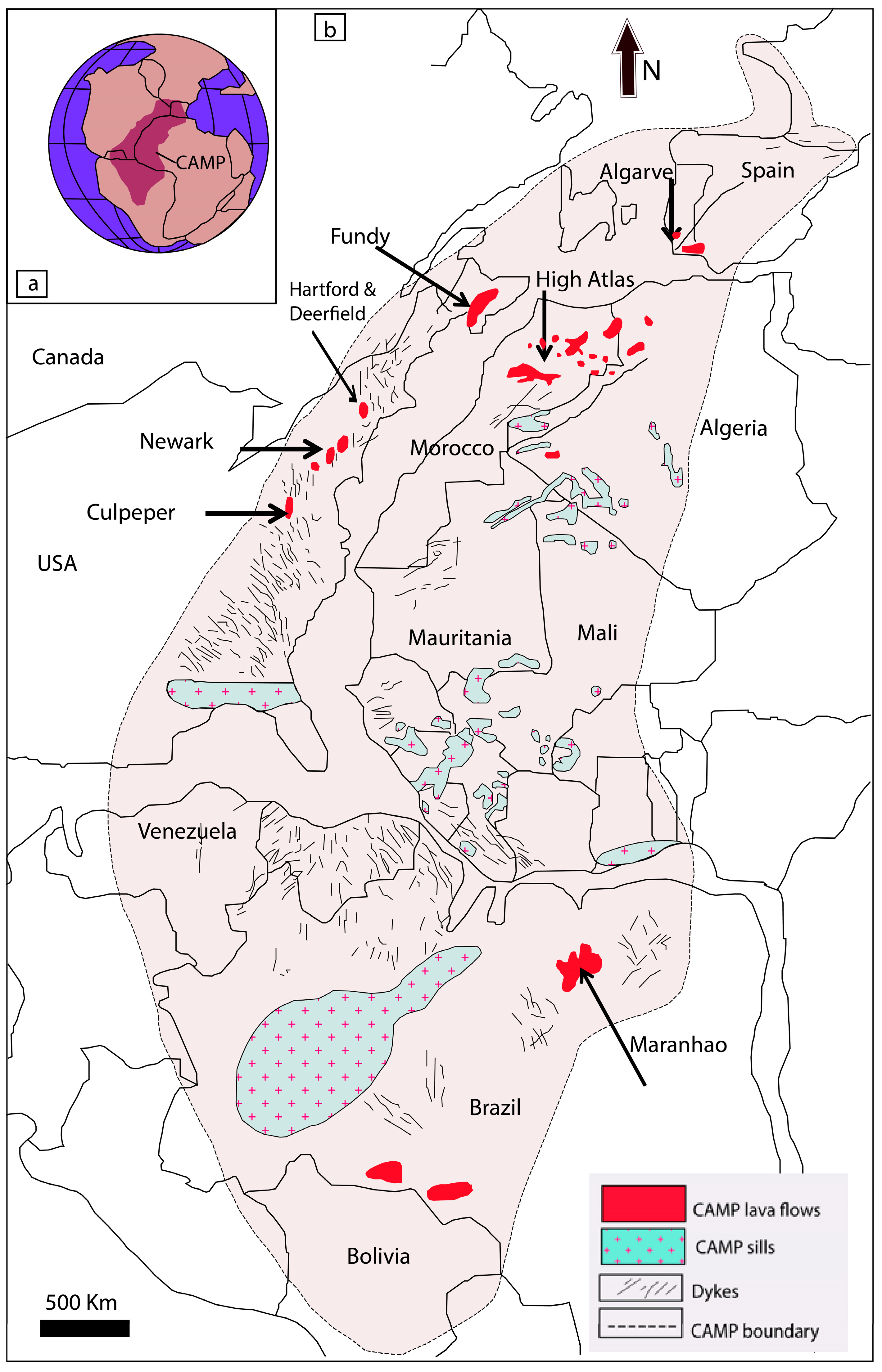
Figure 1. (a) location map of Africa–South America–North America, Greenland, and Europe at 201 Ma and CAMP schematic extent; (b) paleogeographic extent of ca 201 Ma Central Atlantic Magmatic Province (CAMP) across the central Pangean supercontinent (after McHone [6,23,28]).
Geosciences 14 00204 g001
Figure 2. (a) Early Mesozoic rift basins in eastern North America: 1, Fundy; 2, Hartford; 3, Newark; 4, Gettysburg; 5, Culpeper; 6, Danville; (b) Geologic sketch map of Hartford, Deerfield, and Pomperaug (Southbury) basins; (c) Stratigraphic column of Newark Supergroup in the Hartford basin (after [23]).
Geosciences 14 00204 g002
Figure 3. Ideal diagram showing feature structures of inflated pahoehoe sheet lobes [70]. The left side of the column shows the characteristic three-part division of sheet lobes (a) and jointing styles (b) CRZ, crustal zone; PLZ, platy zone; CLZ, columnar zone. The right side of the column illustrates the distribution of (c) vesiculation structures (VZ, vesicular zone; MV, mega-vesicle; HVS, horizontal vesicle sheet; VC, vesicle cylinder; SV, segregation vesicle; PV, pipe vesicle; BVZ, basal vesicular zone), (d) vesiculation (non- to sparsely vesicular d = 0–5 vol%, moderately vesicular m = 10–20 vol% and vesicular v = 30–40 vol%), and (e) degree of crystallinity (G, hyaline; hyh, hypohyaline; hc, hypocrystalline; c, holocrystalline). The scale h/l indicates the normalized height above the base of the sheet lobe (h, height in lobe; l, total lobe thickness).
Geosciences 14 00204 g003
Figure 4. Studied sections of the Talcott Basalt Formation from the Hartford Basin, Connecticut (modified from [34,93]). 1. Section Behind the Target store in Meriden section (N 41°33′9.34″; W 72°49′0.40″); 2. Tariffville section (N 41°54′28.73″; W 72°45′40.18″); 3. King Philip’s Cave section, Talcott Mountain State Park (N 41°50′1.99″; W 72°47′54.08″). BC: Basal Crust; LC: Lava Core; ULC: Upper Lava Crust.
Geosciences 14 00204 g004
Figure 5. The large, long rock-cut behind the Target store in Meriden, Connecticut (a) Contact between the New Haven Formation and the first pillowed flow of the Talcott Basalt Formation. Legend: 1, Blak mudstone, contorted with flame structure and isolated pillows; 2, Contact; 3, Closely (densely) packed pillow. (b) Contact between the first pillowed flow and the second sheet lobe flow of the Talcott Basalt Formation. Note the occurrence of pipe vesicles in the basal crust of the second sheet lobe and the preservation of the glassy zone and radial and concentric cracks. (c) View of the flow units 3, 4, and 5 of the Talcott Basalt Formation. The flow unit 3 is composed of pillow breccias of 2 m gradually overcome by a horizon of 1 m with well-preserved isolated pillow and fragment pillow dispersed in an abundant hyaloclastite matrix which is covered by less than one meter of vesicular lava. The flow unit 4 is constituted by densely packed pillows. Note its compound nature. The last flow unit 5 is a vesicular lava flow. (d) View of the flows units 3, 4, and 5 of the Talcott Basalt Formation. Note the compound nature of the flow units 3 and 4. The flow unit 4 with densely packed pillows is emplaced in paleochannel.
Geosciences 14 00204 g005
Figure 6. Plot of pillows’ horizontal (H) vs. vertical (V) dimensions from (a) unit 1 of Talcott Basalt from (Behind the Target outcrop (Hartford Basin); (b) unit 1 of the Deerfield basalt from the Springfield outcrop (Deerfield Basin).
Geosciences 14 00204 g006
Figure 7. Pipe vesicles and large pillow lava located in the large, long rock cut behind the Target store in Meriden, Connecticut (a) Internal structure of pillow lava of the first pillowed flow of the Talcott Basalt Formation (toward the top of the unit). Location: The large, long rock-cut behind the Target store in Meriden, Connecticut. (b) Detail of the contact between the first pillowed flow and the second sheet lobe flow of the Talcott Basalt Formation. Note the occurrence of unfilled pipe vesicles in the basal crust of the second sheet lobe.
Geosciences 14 00204 g007
Figure 8. Pictures took in the large, long rock-cut behind the Target store in Meriden, Connecticut. (a,b) Closely (densely) packed pillow; the first pillowed flow of the Talcott Basalt Formation (toward the top of the unit). Note that the hyaloclastite matrix between pillows becomes more abundant. (c) Contact between the first pillowed flow and the second sheet lobe flow of the Talcott Basalt Formation. Note the occurrence of pipe vesicles in the basal crust of the second sheet lobe and the preservation of the glassy zone and radial and concentric cracks. (c) Mega-vesicles, including half-moon vesicles and horizontal vesicle sheet of the second sheet lobe flow of the Talcott Basalt Formation. Segregation structures of pahoehoe flow types are located at the top of the lava core of the love. Location: The large, long rock-cut behind the Target store in Meriden, Connecticut. (d) Large pillow lava with digitation form of the first pillowed flow of the Talcott Basalt Formation (toward the top of the unit).
Geosciences 14 00204 g008
Figure 9. (a) Fluidal peperites of the Neptunian dyke of Figure 9b Photograph of jigsaw-fit clasts in basaltic breccia from the Neptunian dyke. This type of jigsaw-fit texture is a common feature of blocky and fluidal peperites and is thought to reflect in situ quench fragmentation. (b) Blockey peperite of the Neptunian dyke of Figure 9b arkose host sediments inject fissures of blocky juvenile clast with typical jigsaw-fit texture, indicating that the peperite has typical features of blocky peperite. Blocky peperite is formed in the background of magma, producing brittle crackings. When hot magma intrudes cold wet sediments, hot magma generates quenching distortion and forms juvenile clasts. (c) Neptunian dyke (clastic dyke) cross-cutting the Talcott Basalt Formation at about 3 km ESE of the quarry of Tilcon Connecticut/North Branford on Fox Road. This basalt breccia-filled fissure with an arkosic matrix and peperites (both blocky and fluidal peperites are present) shows a chilled margin and injected Arkose pocket with the Talcott Basalt. Blocky peperites and mixed blocky and fluidal peperites formed where rising melt interacted explosively with groundwater and with coarse, water-saturated sediments of the New Haven Formation, and underwent brittle quench fragmentation. See Figures S13 and S14 for details of peperites. (d) Fluidal peperites in the Contact of the Hampden Basalt with the East Berlin Fm near Berlin along the RT-9 South. (e) Detail of the well-developed layers of blackish spherule layers (accretionary lapilli?). (f) Well-developed layers of blackish spherule layers (accretionary lapilli?) that might represent basaltic lapilli occur a few cm below the first pillowed flow of the Talcott Basalt Formation located in the large, long rock-cut behind the Target store in Meriden, Connecticut.
Geosciences 14 00204 g009
Figure 10. Panoramic view of the Holyoke flood-basalt flow in the North Branford Quarry, Connecticut. Note the Cuspate boundary (dashed line) separating radiating joints in entablature from vertical columnar joints in the colonnade of the Holyoke flood-basalt flow. The boundary is approximately 120 m above the base of this 200-m-thick section through the flow. The centers of the two cusps are 15 m apart.
Geosciences 14 00204 g010
Figure 11. Lithostratigraphic columns across the Holyoke basalts in the Hartford and Deerfield basins (modified from [34,93]). 1. Section of the Tilcon quarry near North Branford Town, Connecticut (N 41°20′31.81″; W 72°47′39.28″); 2. section of Cooks Gap, Plainville, Hartford County, Connecticut (N 41°40′28.72″; W 72°49′44.95″); 3. and 4. sections of Deerfield basalt sequence at French King Highway, Gill (3) (N 41°40′28.72″; W 72°49′44.95″) and Turner Falls; (4) (N 41°40′28.72″; W 72°49′44.95″), Massachusetts. Note that each lithostratigraphic column has its scale. BC: basal crust. LCR: lava core. ULC: upper lava crust.
Geosciences 14 00204 g011
Figure 12. (a) The two flows of the Holyoke Basalt in the Tom Holyoke Mountains Quarry, Massachusetts. (b,c) Vesicle Cylinder of the lava core of the Holyoke flood-basalt flow in the North Branford Quarry, Connecticut. (d) Fault/Squeez up N30–40, 75–85 SW affecting the first flow of the Holyoke Basalt in the Tom Holyoke Mountains Quarry, Massachusetts. (e) Segregation sheets of coarse-grained ferrodiorite of the Holyoke flood-basalt flow in the North Branford Quarry, Connecticut.
Geosciences 14 00204 g012
Figure 13. Lithostratigraphic columns across the Hampden basalts in the Hartford basin (modified from Gray [34]). 1. Section along the RT-9 South, Berlin, Connecticut (N 41°37′19.05″; W 72°44′11.07″); 2. Section of the Rock Ridge Park, Hartford, Connecticut (N 41°45′3.08″; W 72°41′36.67″).
Geosciences 14 00204 g013
Figure 14. (a,b) Horizontal vesicular zone of Hampden Basalt at the Section of the Rock Ridge Park, Hartford, Connecticut; (c) contact of the Hampden Basalt with the East Berlin Fm. near Berlin along the RT-9 South; (d) contact of the Hampden Basalt with the East Berlin Fm. near Berlin along the RT-9 South with pipe vesicles; (e) ash bed (Pompton Tuff Bed) of the East Berlin Fm. with orange color near Berlin along the RT-9 South, Connecticut; (g) flow top breccia of Hampden Basalt at the Section of the Rock Ridge Park, Hartford, Connecticut; (f) detail of Flow top breccia of Hampden Basalt at the Section of the Rock Ridge Park, Hartford, Connecticut.
Geosciences 14 00204 g014
Figure 15. (a) Contact between the Deerfield Basalt and the Sugarloaf Arkose Formation near Greenfield along the Mohawk Trail (RT-2A). Left side before crossing the French King Bridge and entering Greenfield. The development of peperites underlines the contact. (b) Horizontal vesicular zone of the Upper Crust of the second sheet lobe of the Deerfield Basalt Formation near Greenfield along the Mohawk Trail (RT-2A). Right side before reaching the French King Bridge and entering Greenfield.
Geosciences 14 00204 g015
Table 1. Calculated cooling time for sheet lobes from different large igneous provinces using the empirical cooling model of Hon et al. (1994) [85]. Abbreviations: KB, Karroo Basalt; CRBG, Colombia River Basalt Group; CAMP, Central Atlantic Magmatic Province.
Flow Field or Basalt Unit/BasinDurationReference
Talcott Basalt/Hartford 18 to 51 monthsThis work
Holyoke Basalt/Hartford 136 yearsThis work
Hampden Basalt/Hartford 2 monthsThis work
Deerfield basalt/Deerfield5 monthsThis work
Orange Mountain Basalt/Newark 3 yearsPuffer et al. (2018) [42]
North Mountain Basalt/Fundy7 days to 5 months Kontak, (2008) [25]
Ait Ourir/Central High Atlas22 to 121 monthsEl Hachimi (2012) [43]
Argana (Alemzi South)/Argana0.3 to 23 monthsEl Hachimi (2012) [43]
Tiourjdal/Central High Atlas0.11 to 22 monthsEl Hachimi (2012) [44]
Naude’s Nek Pass/Karoo11 to 27 days Jay et al. (2018) [117]
Palouse Falls, Ginkgo, and Sand Hollow/Pasco19.3, 8.3, and 16.9 yearsVye-Brown et al. (2013) [118]
Disclaimer/Publisher’s Note: The statements, opinions and data contained in all publications are solely those of the individual author(s) and contributor(s) and not of MDPI and/or the editor(s). MDPI and/or the editor(s) disclaim responsibility for any injury to people or property resulting from any ideas, methods, instructions or products referred to in the content.