UAV, GNSS, and GIS for the Rapid Assessment of Multi-Occurrence Landslides
Abstract
1. Introduction
2. Study Area and Geological Background
3. Materials and Methods
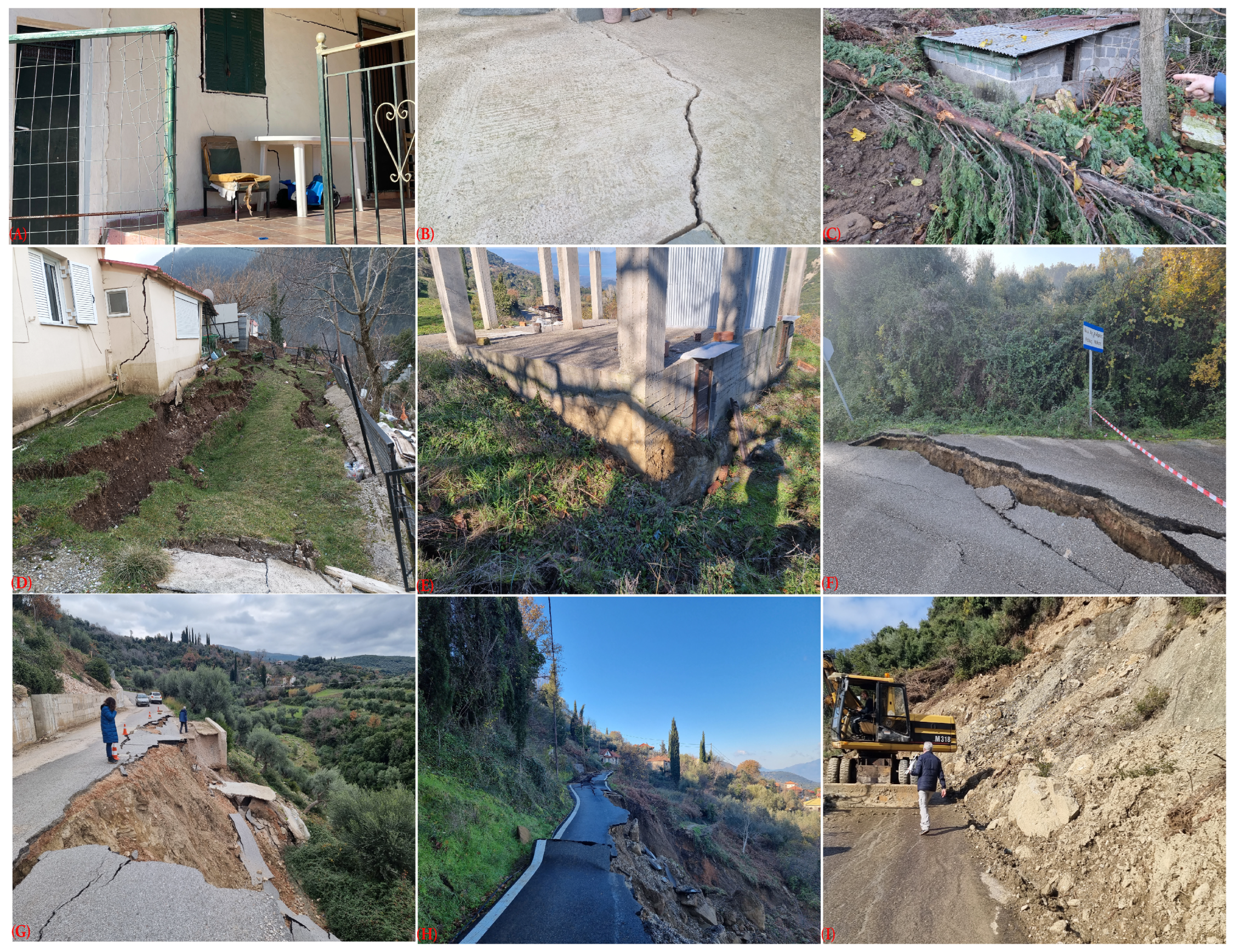
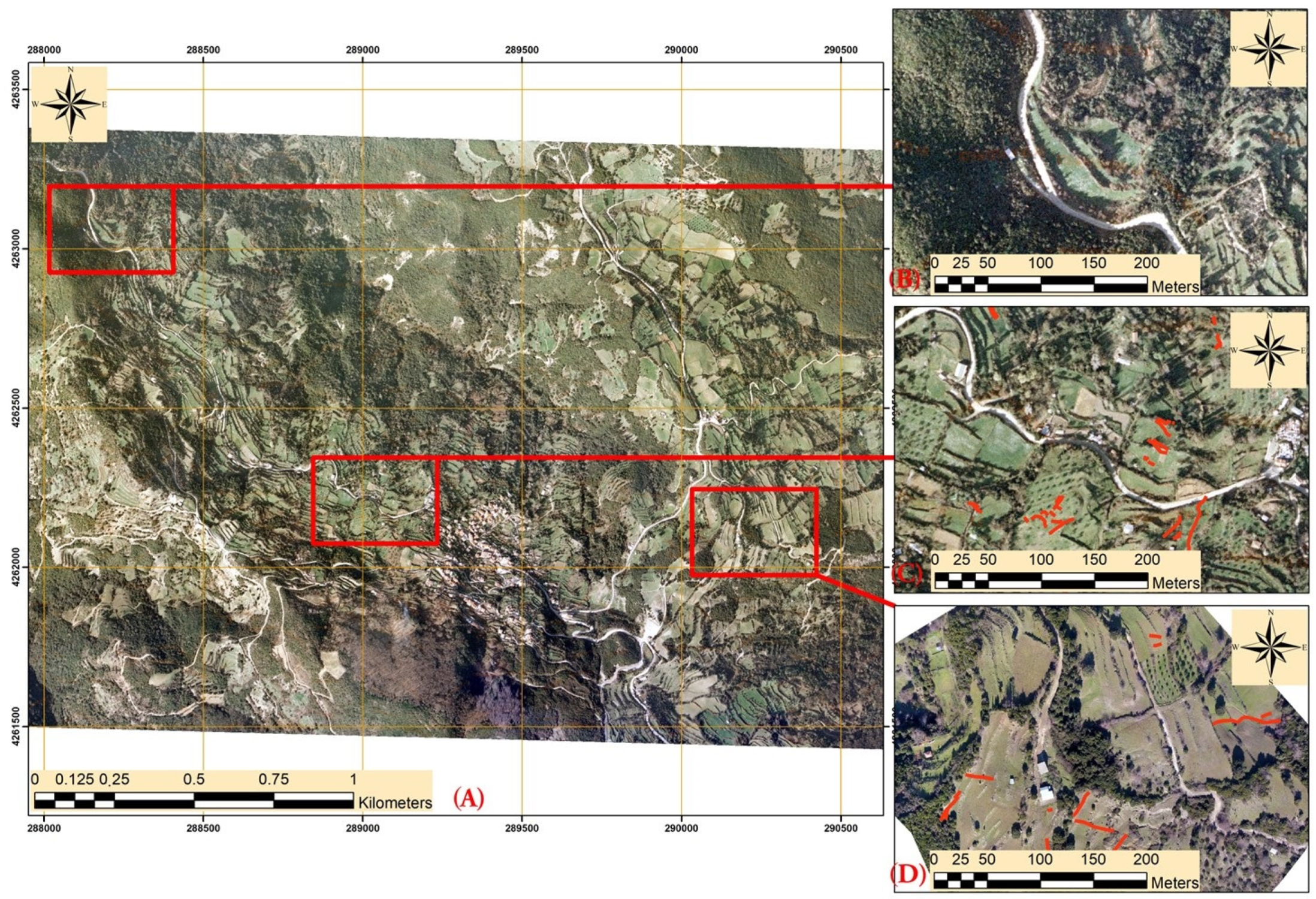
4. Multi-Occurrence Landslide Events
4.1. First Event
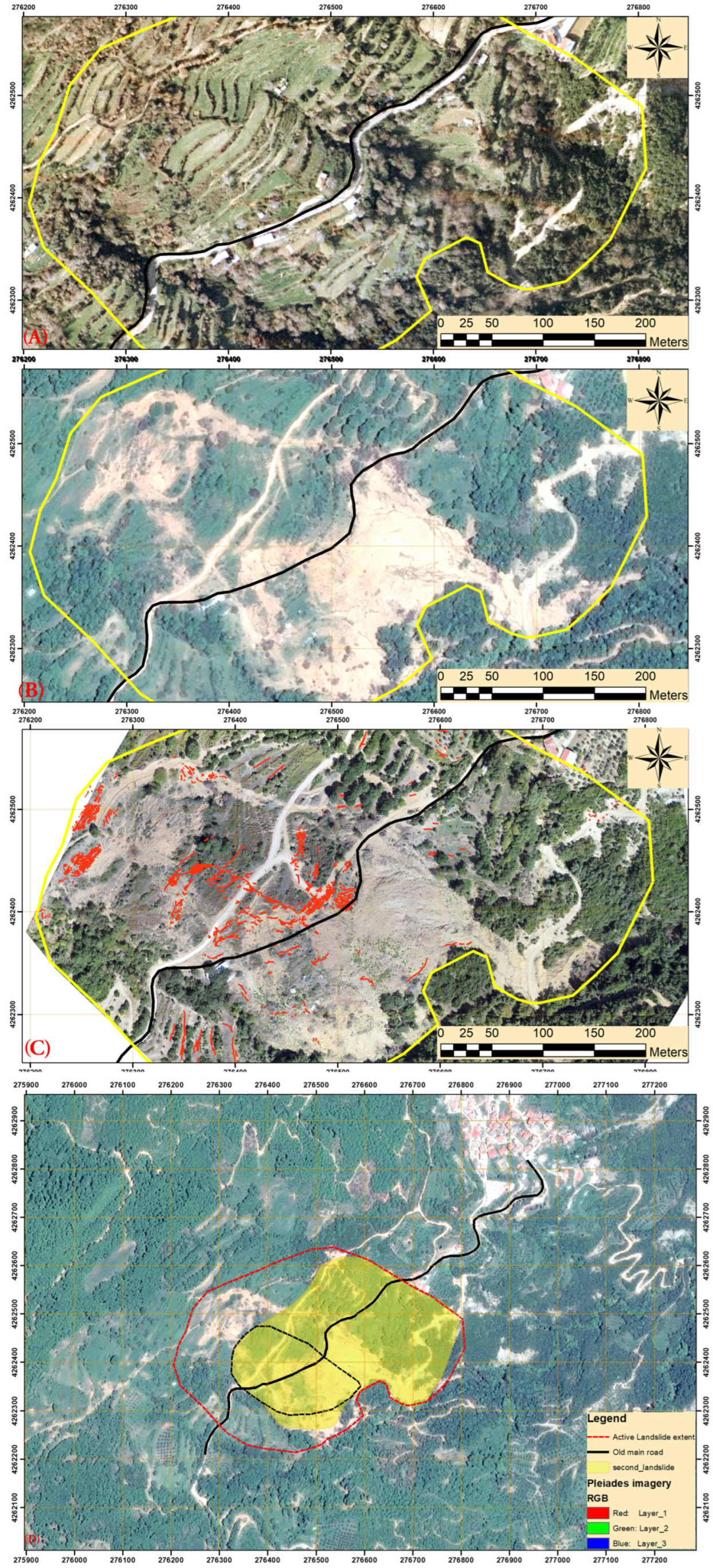
4.2. Second Event
5. Damage Mapping
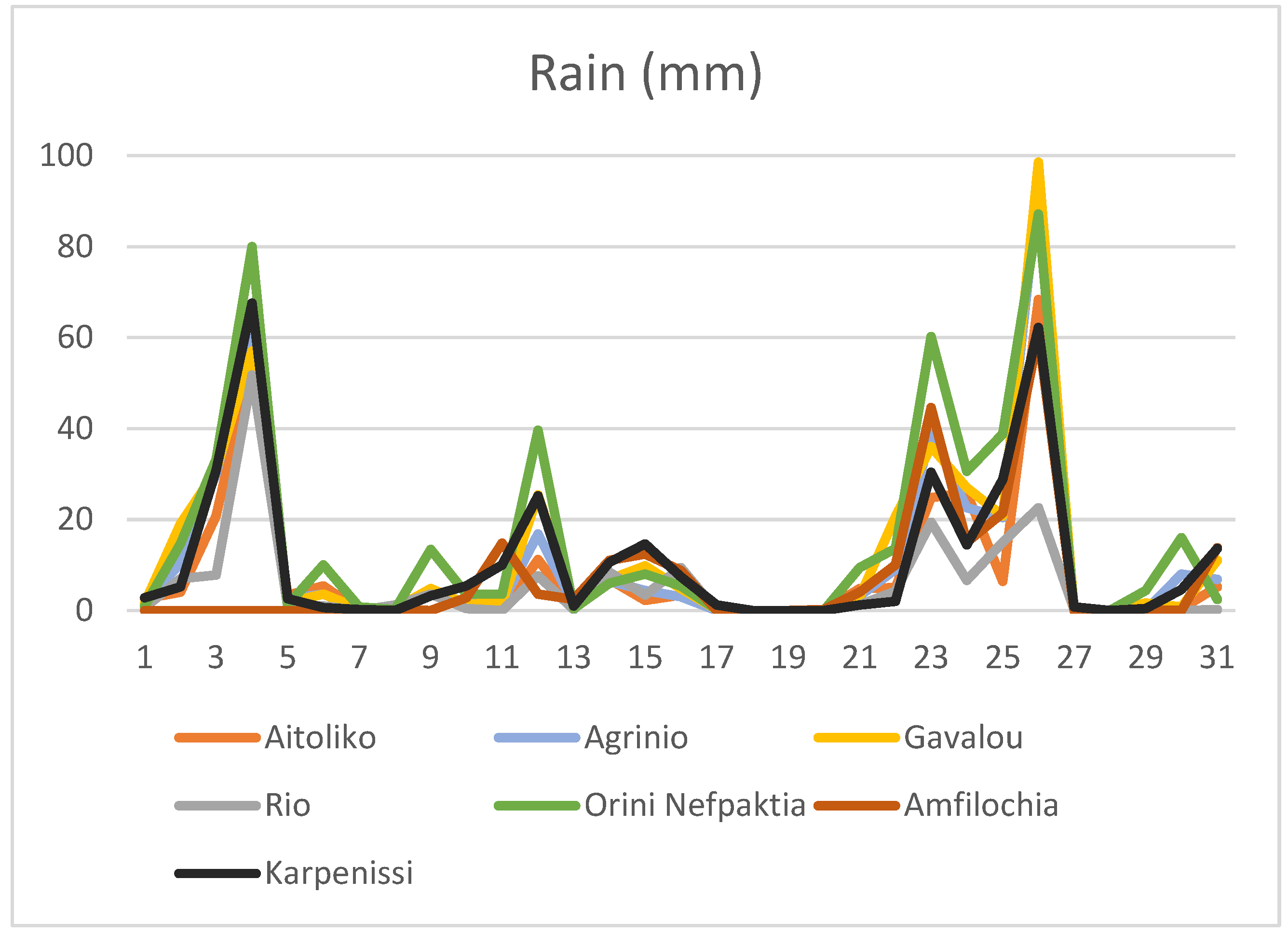
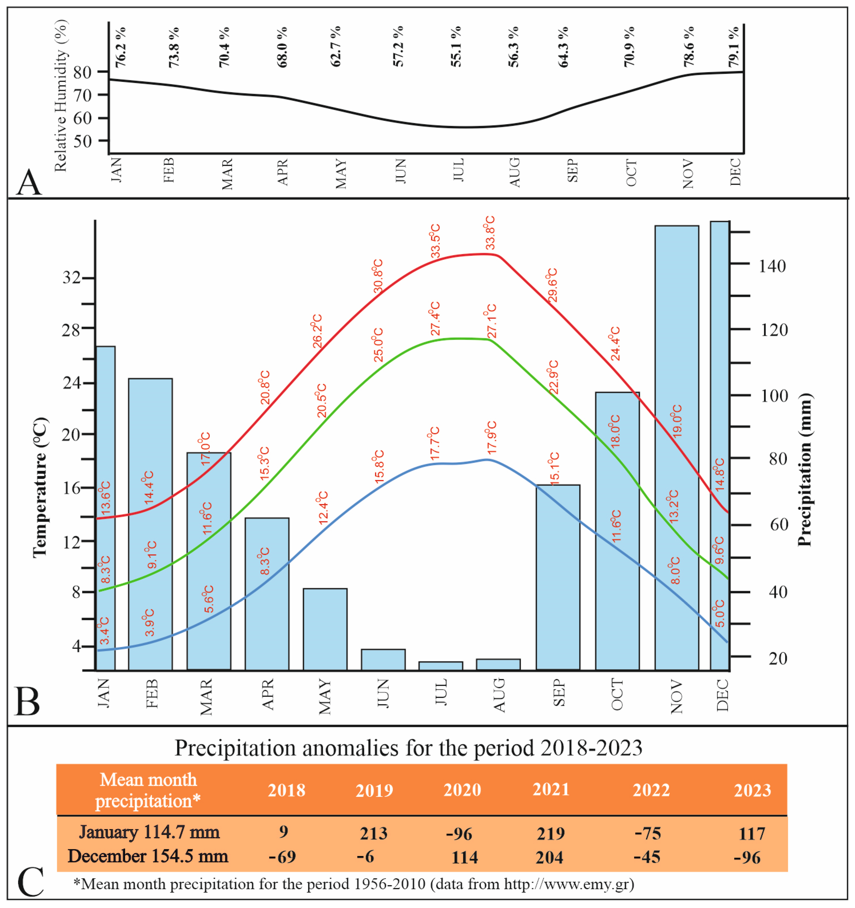
6. Meteorological Data Analysis and Discussion
7. Conclusions
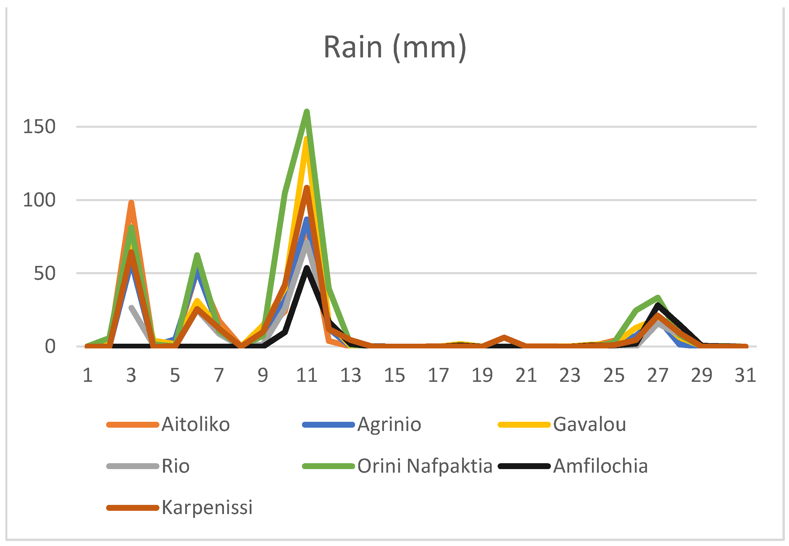
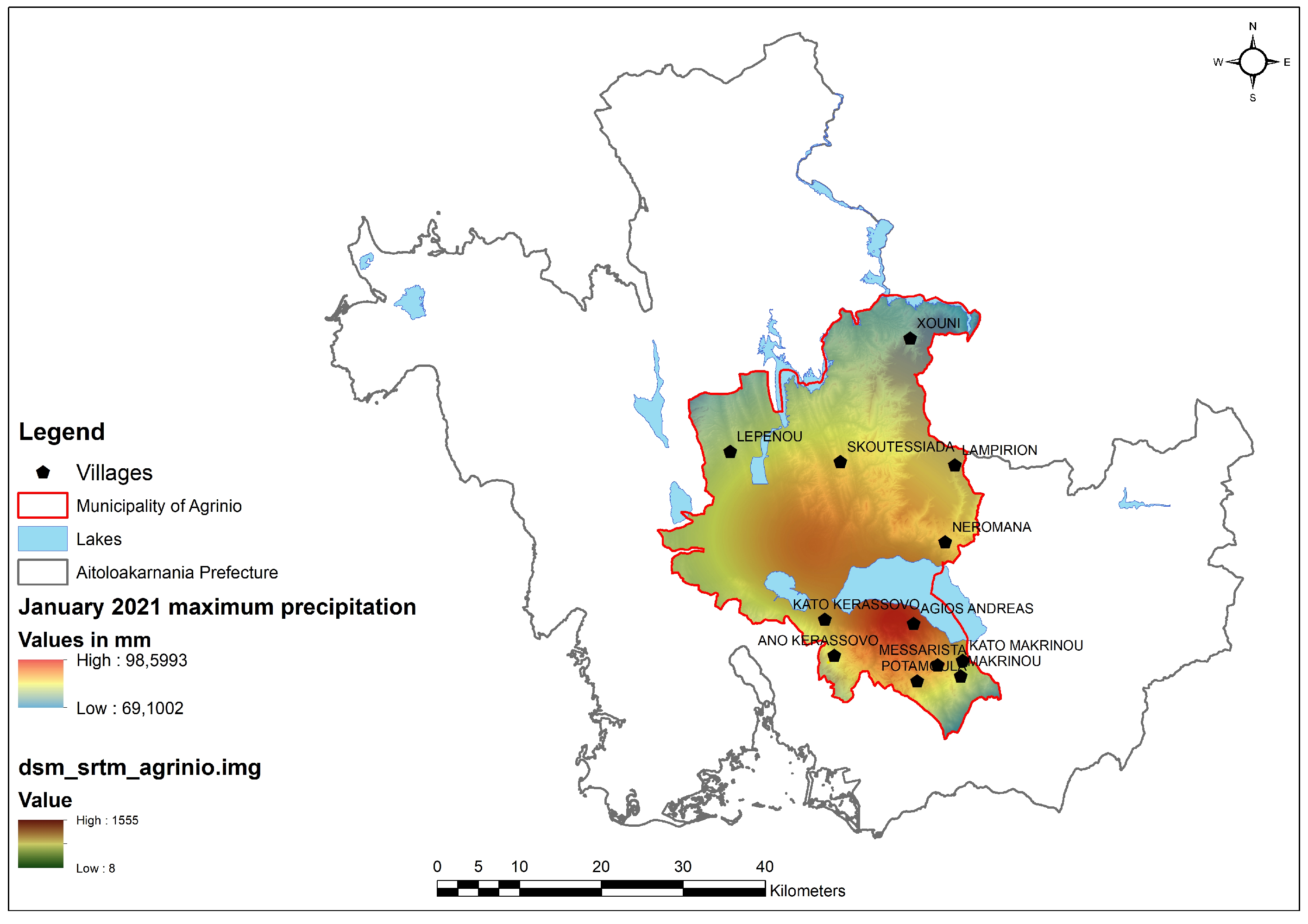
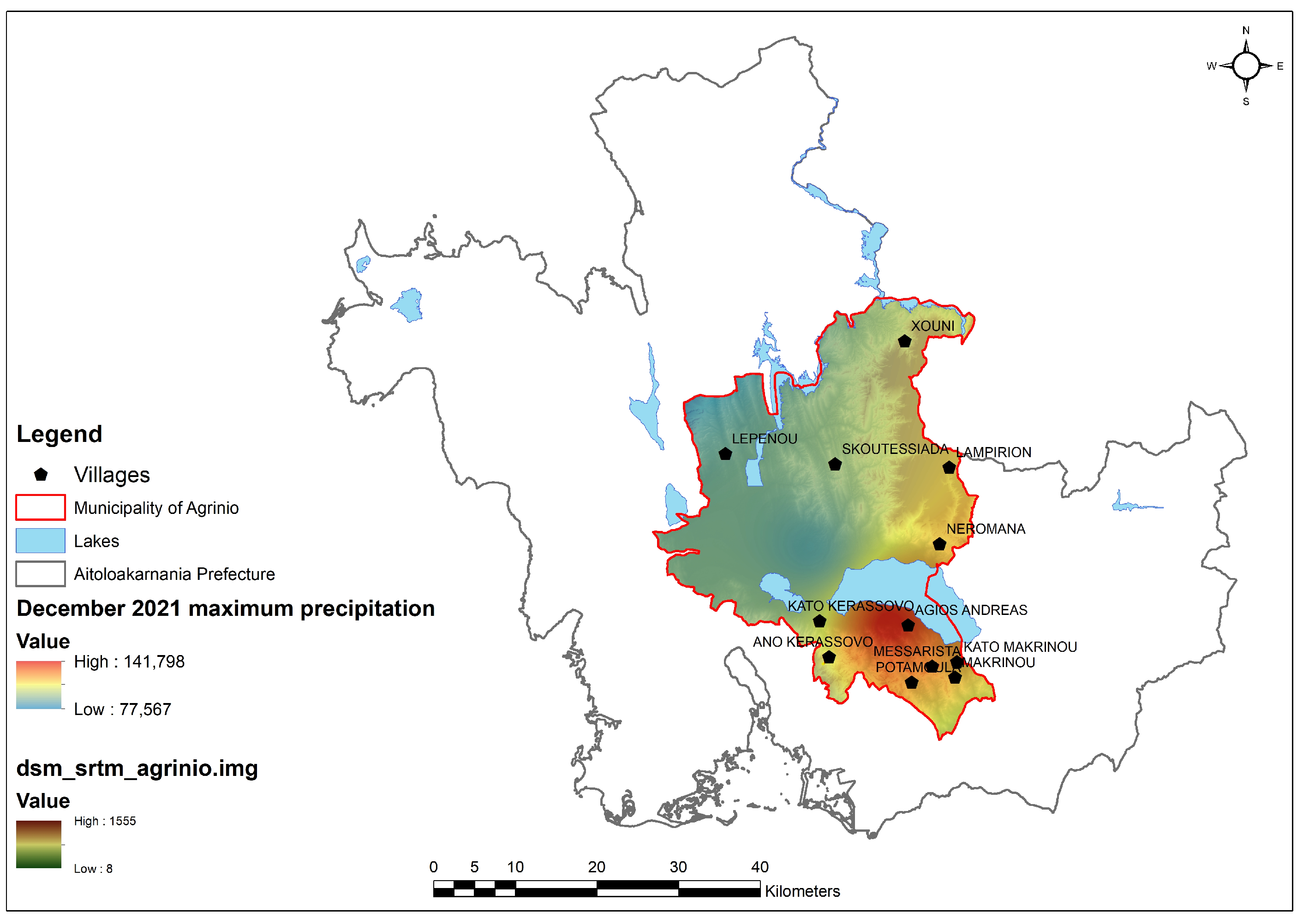
- It was proven that there is a threshold in precipitation height that triggers the MORLEs in the specific area. Specifically, the value of the daily precipitation was detected at 80 mm. This was the daily rainfall peak of 21 January, while the respective threshold of 21 December is somewhat higher, reaching 140 mm.
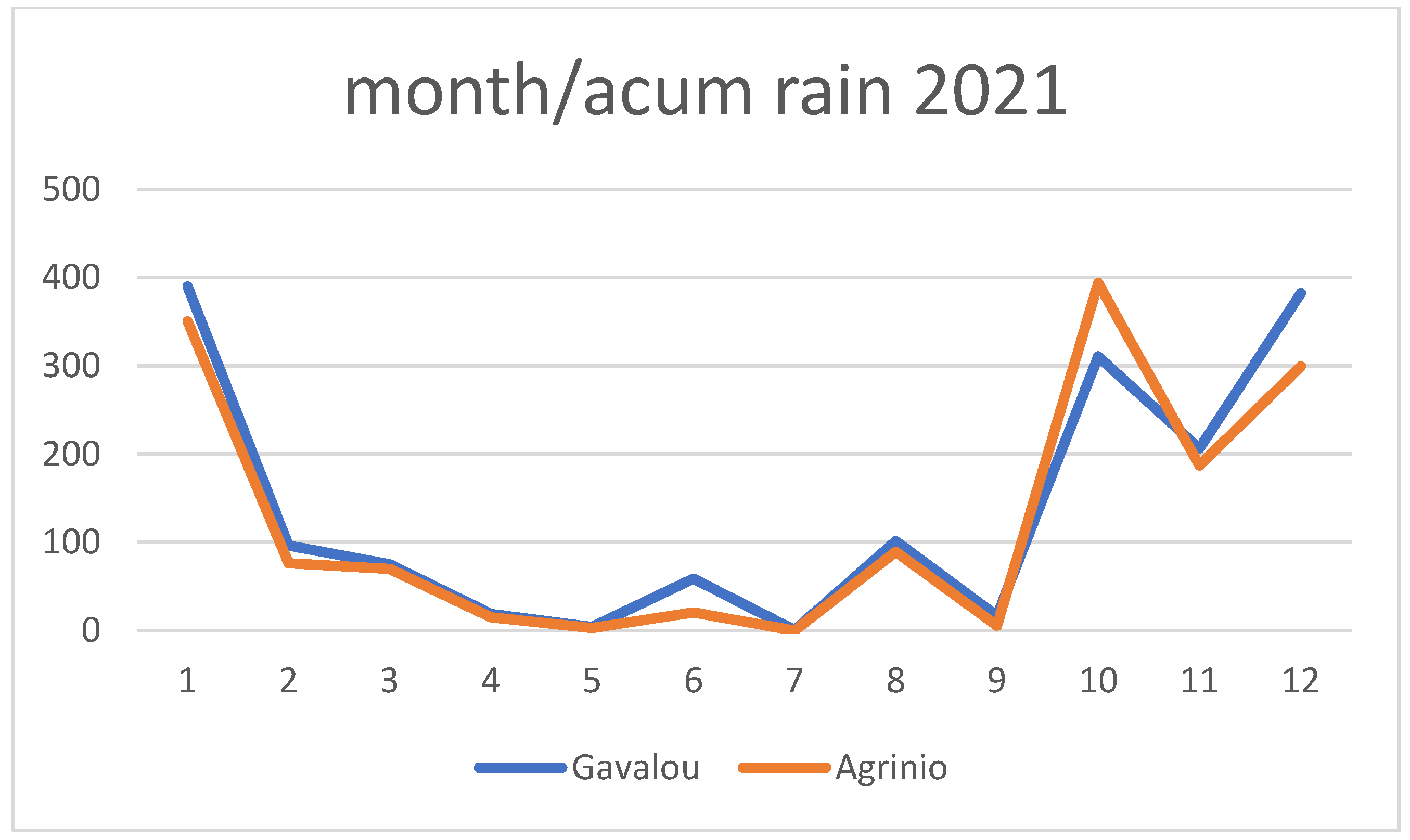
- In general, it was mentioned that in the specific year under study, there were two precipitation peaks in January and December in comparison to the mean precipitation values for the period 1956–2010.
- Satellite data with very high spatial resolution, such as Pleiades, can be used for the MORLEs mapping; however, these data are quite expensive and acquired only on demand. UAV imagery is the most effective solution for the rapid assessment of such phenomena when the number of the landslides is high and their extent is limited.
- The combination of UAV, GNSS, and GIS is proposed for the accurate mapping of the damage and the provision of crucial information to the local stakeholders.
Supplementary Materials
Author Contributions
Funding
Data Availability Statement
Conflicts of Interest
References
- Clague, J.J.; Stead, D. (Eds.) Landslides: Types, Mechanisms and Modeling; Cambridge University Press: Cambridge, UK, 2012. [Google Scholar] [CrossRef]
- Froude, M.J.; Petley, D. Global fatal landslide occurrence from 2004 to 2016. Nat. Hazards Earth Syst. Sci. 2018, 18, 2161–2181. [Google Scholar] [CrossRef]
- Haque, U.; da Silva, P.F.; Devoli, G.; Pilz, J.; Zhao, B.; Khaloua, A.; Wilopo, W.; Andersen, P.; Lu, P.; Lee, J.; et al. The human cost of global warming: Deadly landslides and their triggers (1995–2014). Sci. Total Environ. 2019, 682, 673–684. [Google Scholar] [CrossRef] [PubMed]
- The Deadliest Landslides In Recorded History. Available online: https://www.worldatlas.com/natural-disasters/the-deadliest-landslides-in-recorded-history.html (accessed on 6 June 2024).
- Crozier, M.J. Multiple-occurrence regional landslide events in New Zealand: Hazard management issues. Landslides 2005, 2, 247–256. [Google Scholar] [CrossRef]
- Crozier, M.J. Reprint of “A proposed cell model for multiple-occurrence regional landslide events: Implications for landslide susceptibility mapping”. Geomorphology 2018, 307, 3–11. [Google Scholar] [CrossRef]
- Caine, N. The Rainfall Intensity—Duration Control of Shallow Landslides and Debris Flows. Geogr. Ann. Ser. A Phys. Geogr. 1980, 62, 23–27. [Google Scholar] [CrossRef]
- Giannecchini, R.; Galanti, Y.; D’Amato Avanzi, G. Critical rainfall thresholds for triggering shallow landslides in the Serchio River Valley (Tuscany, Italy). Nat. Hazards Earth Syst. Sci. 2012, 12, 829–842. [Google Scholar] [CrossRef]
- Guzzetti, F.; Peruccacci, S.; Rossi, M.; Stark, C.P. Rainfall thresholds for the initiation of landslides in central and southern Europe. Meteorol. Atmos. Phys. 2007, 98, 239–267. [Google Scholar] [CrossRef]
- Hungr, O.; Leroueil, S.; Picarelli, L. The Varnes classification of landslide types, an update. Landslides 2014, 11, 167–194. [Google Scholar] [CrossRef]
- Buxó, P.; Oller, P.; Xifré, D.; Fabregat, I.; Marturià, J.; Janeras, M. Identification, validation and assessment of Multiple Occurrence Regional Landslide Events (MORLE) in Catalonia (Spain) during the last one hundred years. In Proceedings of the EGU General Assembly 2021, Online, 19–30 April 2021. EGU21-6171. [Google Scholar] [CrossRef]
- Abancó, C.; Bennett, G.L.; Matthews, A.J.; Matera, M.A.M.; Tan, F.J. The role of geomorphology, rainfall and soil moisture in the occurrence of landslides triggered by 2018 Typhoon Mangkhut in the Philippines. Nat. Hazards Earth Syst. Sci. 2021, 21, 1531–1550. [Google Scholar] [CrossRef]
- Yamada, M.; Matsushi, Y.; Chigira, M.; Mori, J. Seismic recordings of landslides caused by Typhoon Talas (2011), Japan. Geophys. Res. Lett. 2012, 39, 1–5. [Google Scholar] [CrossRef]
- Okuwaki, R.; Fan, W.; Yamada, M.; Osawa, H.; Wright, T.J. Identifying landslides from continuous seismic surface waves: A case study of multiple small-scale landslides triggered by Typhoon Talas, 2011. Geophys. J. Int. 2021, 226, 729–741. [Google Scholar] [CrossRef]
- Rouault, C. Extreme Multiple Landslide Events in Norway An Investigation of Rainfall and Snowmelt Induced Soil Landslide Detection and Forecasting. Master’s Thesis, Cold Climate Engineering, Norwegian University of Science and Technology, Faculty of Engineering, Department of Civil and Environmental Engineering, Trondheim, Norway, 2020. [Google Scholar]
- Tehrani, F.S.; Santinelli, G.; Herrera, M.H. Multi-Regional landslide detection using combined unsupervised and supervised machine learning. Geomat. Nat. Hazards Risk 2021, 12, 1015–1038. [Google Scholar] [CrossRef]
- Chou, T.-Y.; Yeh, M.-L.; Chen, Y.-C.; Chen, Y.-H. Disaster monitoring and management by the unmanned aerial vehicle technology. In Proceedings of the ISPRS TC VII Symposium—100 Years ISPRS, Vienna, Austria, 5–7 July 2010. [Google Scholar]
- Casagli, N.; Frodella, W.; Morelli, S.; Tofani, V.; Ciampalini, A.; Intrieri, E.; Raspini, F.; Rossi, G.; Tanteri, L.; Lu, P. Spaceborne, UAV and ground-based remote sensing techniques for landslide mapping, monitoring and early warning. Geoenviron. Disasters 2017, 4, 9. [Google Scholar] [CrossRef]
- Ciccarese, G.; Tondo, M.; Mulas, M.; Bertolini, G.; Corsini, A. Rapid Assessment of Landslide Dynamics by UAV-RTK Repeated Surveys Using Ground Targets: The Ca’ Lita Landslide (Northern Apennines, Italy). Remote Sens. 2024, 16, 1032. [Google Scholar] [CrossRef]
- Godone, D.; Allasia, P.; Borrelli, L.; Gullà, G. UAV and Structure from Motion Approach to Monitor the Maierato Landslide Evolution. Remote Sens. 2020, 12, 1039. [Google Scholar] [CrossRef]
- Notti, D.; Giordan, D.; Cina, A.; Manzino, A.; Maschio, P.; Bendea, I.H. Debris Flow and Rockslide Analysis with Advanced Photogrammetry Techniques Based on High-Resolution RPAS Data. Ponte Formazza Case Study (NW Alps). Remote Sens. 2021, 13, 1797. [Google Scholar] [CrossRef]
- Sestras, P.; Bilașco, Ș.; Roșca, S.; Dudic, B.; Hysa, A.; Spalević, V. Geodetic and UAV Monitoring in the Sustainable Management of Shallow Landslides and Erosion of a Susceptible Urban Environment. Remote Sens. 2021, 13, 385. [Google Scholar] [CrossRef]
- Lucieer, A.; de Jong, S.M.; Turner, D. Mapping landslide displacements using Structure from Motion (SfM) and image correlation of multi-temporal UAV photography. Progress Phys. Geogr. Earth Environ. 2014, 38, 97–116. [Google Scholar] [CrossRef]
- Turner, D.; Lucieer, A.; De Jong, S.M. Time Series Analysis of Landslide Dynamics Using an Unmanned Aerial Vehicle (UAV). Remote Sens. 2015, 7, 1736–1757. [Google Scholar] [CrossRef]
- Yermolaev, O.; Usmanov, B.; Gafurov, A.; Poesen, J.; Vedeneeva, E.; Lisetskii, F.; Nicu, I.C. Assessment of Shoreline Transformation Rates and Landslide Monitoring on the Bank of Kuibyshev Reservoir (Russia) Using Multi-Source Data. Remote Sens. 2021, 13, 4214. [Google Scholar] [CrossRef]
- Rau, J.; Jhan, J.; Lo, C.; Lin, Y. Landslide mapping using imagery acquired by a fixed-wing UAV. Int. Arch. Photogramm. Remote Sens. Spat. Inf. Sci. 2011, 38, 195–200. [Google Scholar] [CrossRef]
- Shi, B.; Liu, C. UAV for landslide mapping and deformation analysis. In Proceedings of the International Conference on Intelligent Earth Observing and Applications, Guilin, China, 23–24 October 2015; International Society for Optics and Photonics: Bellingham, WA, USA, 2015; Volume 9808. [Google Scholar] [CrossRef]
- Peternel, T.; Kumelj, Š.; Oštir, K.; Komac, M. Monitoring the Potoška planina landslide (NW Slovenia) using UAV photogrammetry and tachymetric measurements. Landslides 2017, 14, 395–406. [Google Scholar] [CrossRef]
- Cignetti, M.; Godone, D.; Wrzesniak, A.; Giordan, D. Structure from motion multisource application for landslide characterization and monitoring: The champlas du col case study, sestriere, North-Western Italy. Sensors 2019, 19, 2364. [Google Scholar] [CrossRef]
- Antoine, R.; Lopez, T.; Tanguy, M.; Lissak, C.; Gailler, L.; Labazuy, P.; Fauchard, C. Geoscientists in the sky: Unmanned aerial vehicles responding to geohazards. Surv. Geophys. 2020, 41, 1285–1321. [Google Scholar] [CrossRef]
- Catani, F. Landslide detection by deep learning of non-nadiral and crowdsourced optical images. Landslides 2020, 18, 1025–1044. [Google Scholar] [CrossRef]
- Doutsos, T.; Koukouvelas, I.K.; Xypolias, P. A new orogenic model for the External Hellenides. Geol. Soc. Lond. Spec. Publ. 2006, 260, 507–520. [Google Scholar] [CrossRef]
- Skourlis, K.; Doutsos, T. The Pindos Fold-and-thrust belt (Greece): Inversion kinematics of a passive continental margin. Int. J. Earth Sci. 2003, 92, 891–903. [Google Scholar] [CrossRef]
- Nikolakopoulos, K.G.; Kyriou, A.; Koukouvelas, I.K.; Tomaras, N.; Lyros, E. UAV, GNSS, and InSAR Data Analyses for Landslide Monitoring in a Mountainous Village in Western Greece. Remote Sens. 2023, 15, 2870. [Google Scholar] [CrossRef]
- Nikolakopoulos, K.G.; Kyriou, A.; Koukouvelas, I.K. Developing a Guideline of Unmanned Aerial Vehicle’s Acquisition Geometry for Landslide Mapping and Monitoring. Appl. Sci. 2022, 12, 4598. [Google Scholar] [CrossRef]
- Kyriou, A.; Nikolakopoulos, K.; Koukouvelas, I. How Image Acquisition Geometry of UAV Campaigns Affects the Derived Products and Their Accuracy in Areas with Complex Geomorphology. ISPRS Int. J. Geo-Inf. 2021, 10, 408. [Google Scholar] [CrossRef]
- Ciccarese, G.; Mulas, M.; Alberoni, P.P.; Truffelli, G.; Corsini, A. Debris flows rainfall thresholds in the Apennines of Emilia-Romagna (Italy) derived by the analysis of recent severe rainstorms events and regional meteorological data. Geomorphology 2020, 358, 107097. [Google Scholar] [CrossRef]
- Ciccarese, G.; Mulas, M.; Corsini, A. Combining spatial modelling and regionalization of rainfall thresholds for debris flows hazard mapping in the Emilia-Romagna Apennines (Italy). Landslides 2021, 18, 3513–3529. [Google Scholar] [CrossRef]
- Argyriou, A.V.; Polykretis, C.; Teeuw, R.M.; Papadopoulos, N. Geoinformatic Analysis of Rainfall-Triggered Landslides in Crete (Greece) Based on Spatial Detection and Hazard Mapping. Sustainability 2022, 14, 3956. [Google Scholar] [CrossRef]



| No | Study Area | Dimensions | Damage in Buildings |
|---|---|---|---|
| 1 | Kerassovo inside the village | 150 m width, 400 m length | X |
| 2 | Kerassovo outside of the village | 100 m width, 150 m length | |
| 3 | Kerassovo on the road to Messolonghi | 80 m width, 250 m length |
| No | Study Area | Dimensions | Damage in Buildings |
|---|---|---|---|
| 1 | Agios Andreas | 50 m width | |
| 2 | Messarista first before the village entrance | 100 m width | |
| 3 | Messarista second village entrance | 150 m width | |
| 4 | Messarista third inside the village | 250 m width | Χ |
| 5 | Messarista fourth Upper neighborhood | 150 m width | Χ |
| 6 | Messarista fifth water pumping building | 300 m width | Χ |
| 7 | Messarista sixth after the village | 200 m width | |
| 8 | Ano Makrionou inside the village | 250 m width | Χ |
| 9 | Ano Makrinou outside of the village | 70 m width | |
| 10 | Ano Kerassovo | 500 m width | Χ |
| 11 | Ano Vlochos | 100 m–500 m | Χ |
| 12 | Neromana on the main road | 50 m width | |
| 13 | Neromana second | 80 m width | |
| 14 | Lampiri—Rapteika | 150 m width | Χ |
| 15 | Chouni—Sagieika | 100 m width | Χ |
| 16 | Lepenou | 50 m width |
| No | Study Area | No of Images Acquired | Altitude | Platform | Spatial Resolution cm |
|---|---|---|---|---|---|
| 1 | Kerassovo inside the village | 250 | 120 | P4pro | 3.3 |
| 2 | Kerassovo outside of the village | 60 | 120 | P4pro | 3.3 |
| 3 | Kerassovo on the road to Messolonghi | 40 | 110 | Matrice 600 | 2.8 |
| 4 | Messarista first before the village entrance | 90 | 120 | Matrice 600 | 3.0 |
| 5 | Messarista second village entrance | 95 | 120 | P4pro | 3.3 |
| 6 | Messarista third inside the village | 75 | 110 | P4pro | 3.0 |
| 7 | Messarista fourth Upper neighborhood | 75 | 110 | P4pro | 3.0 |
| 8 | Messarista fifth water pumping building | 140 | 120 | Matrice 600 | 3.0 |
| 9 | Messarista sixth after the village | 120 | 120 | Matrice 600 | 3.0 |
| 10 | Ano Makrionou inside the village | 80 | 120 | P4pro | 3.3 |
| 11 | Ano Makrinou outside of the village | 90 | 120 | Matrice 600 | 3.0 |
| 12 | Ano Vlochos | 158 | 120 | P4pro | 3.3 |
| 13 | Lampiri—Rapteika | 186 | 110 | Matrice 600 | 2.8 |
| 14 | Chouni—Sagieika | 60 | 90 | P4pro | 2.5 |
Disclaimer/Publisher’s Note: The statements, opinions and data contained in all publications are solely those of the individual author(s) and contributor(s) and not of MDPI and/or the editor(s). MDPI and/or the editor(s) disclaim responsibility for any injury to people or property resulting from any ideas, methods, instructions or products referred to in the content. |
© 2024 by the authors. Licensee MDPI, Basel, Switzerland. This article is an open access article distributed under the terms and conditions of the Creative Commons Attribution (CC BY) license (https://creativecommons.org/licenses/by/4.0/).
Share and Cite
Nikolakopoulos, K.G.; Kyriou, A.; Koukouvelas, I.K. UAV, GNSS, and GIS for the Rapid Assessment of Multi-Occurrence Landslides. Geosciences 2024, 14, 160. https://doi.org/10.3390/geosciences14060160
Nikolakopoulos KG, Kyriou A, Koukouvelas IK. UAV, GNSS, and GIS for the Rapid Assessment of Multi-Occurrence Landslides. Geosciences. 2024; 14(6):160. https://doi.org/10.3390/geosciences14060160
Chicago/Turabian StyleNikolakopoulos, Konstantinos G., Aggeliki Kyriou, and Ioannis K. Koukouvelas. 2024. "UAV, GNSS, and GIS for the Rapid Assessment of Multi-Occurrence Landslides" Geosciences 14, no. 6: 160. https://doi.org/10.3390/geosciences14060160
APA StyleNikolakopoulos, K. G., Kyriou, A., & Koukouvelas, I. K. (2024). UAV, GNSS, and GIS for the Rapid Assessment of Multi-Occurrence Landslides. Geosciences, 14(6), 160. https://doi.org/10.3390/geosciences14060160


