Abstract
In the digital era, highlighting the heritage resources of a mountainous region involves describing and advertising them to promote their visibility and attractiveness. Previous studies mainly assess the natural resources of such regions through a multi-indicator descriptive evaluation. This study aims to develop an effective evaluation of such indicators along the main tourist route of the M’Goun UNESCO Global Geopark, located in the central High Atlas of Morocco. The implementation of an experiential method to assess the tourism characteristics of this region is a notable aspect of our study. It includes analyzing the criteria for choosing this destination by segmenting tourists’ consumption experiences. Statistical data analysis has identified five dimensions of destination choice and four visitor groups. Additionally, we created an interactive map and made it accessible online to promote the natural geoheritage of this region. This article proposes to discuss the findings of this research and their applicability in terms of tourism destination management and decision-making, which can assist local governments in allocating tourism resources and land use rationally.
1. Introduction
The central High Atlas region of Morocco (Figure 1a), encompassing the M’Goun Global Geopark, is recognized for its extensive natural and cultural resources, with the potential to become a premier global tourist destination. Despite its inclusion in the UNESCO Global Geopark Network in 2014, the region’s tourism potential is not fully tapped, and its international visibility remains moderate at best [1]. In the digital era, highlighting geoheritage and cultural values of a remote area begins with their detailed description and advertisement to improve their visibility and appeal. The geological history of the central High Atlas dates back to the Triassic period, around 250 million years ago, with significant developments during the Jurassic period, approximately 180 million years ago. The M’Goun UNESCO Global Geopark features remarkable tectonic structures resulting from the collision of the African and European plates. Among its treasures are sauropod and theropod dinosaur footprints, as well as various mineral deposits like copper, zinc, and iron. Therefore, analyzing the criteria to choose a destination is crucial for identifying its strengths and weaknesses. This analysis is important and can be further considered in territorial planning policies. This study aims to strengthen the tourist appeal of the central High Atlas region in Morocco by highlighting its resources via innovative technologies and to gain insights into the needs and expectations of tourists based on the experiences of 767 respondents who have visited all or part of the studied area.
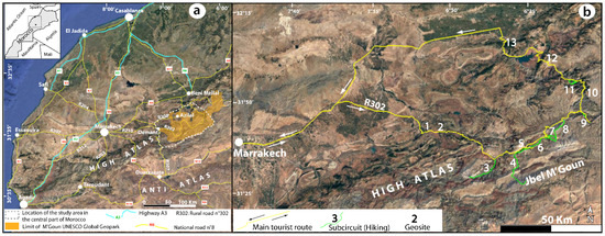
Figure 1.
(a) Location of the study area in the central part of Morocco (Google Earth image 2022). (b) Route of the studied tourist circuit and location of the thirteen sites for which digital data sheets have been produced and integrated into an interactive map: 1. Imi-n-ifri natural bridge; 2. dinosaur footprints, Iwariden; 3. Jbel Rat ascension; 4. Jbel M’Goun ascension; 5. Ait Bouguemez valley trek; 6. dinosaur footprints, Ibakaliwine; 7. hiking Lac Izoughar; 8. Jbel Azourki ascension; 9. hiking Taghia sources; 10. cliffs of Ait Abdi plateau; 11. hike around the Imsfran Cathedral; 12. panoramic view of the Bin El Ouidane dam; 13. panoramic view of the Tadla plain.
Following this research concept, our study is divided into two parts: firstly, we present an objective description of thirteen geological sites in the central High Atlas (Figure 1b), with three sites featured in this article for illustrative purposes. Datasheets, photos, and shapefiles produced for each site have been integrated into an algorithm that we developed using the R programming language [2]. As a result of this initial phase, an interactive map has been created and made available online, providing tourists with access to the site data (link available online, refer to Section 3.1). The second part of this study analyzes the visitor typology of the central High Atlas region, using an experiential approach to tourism consumption [3,4]. Responses gathered from a field survey involving 767 individuals enabled us to better understand the needs and expectations of tourists seeking to visit this region, available online at https://forms.gle/eijD2wghK1oDzYNi9. Based on the reported experiences, we have categorized the respondents into four main groups.
Digital promotion, through interactive platforms, social media, and mobile applications, aims to highlight the visibility and attractiveness of geosites. This type of promotion is critical for attracting specific visitor segments based on their interests and preferences, directly linking to the analysis of visitor typology. Indeed, understanding different visitor categories (such as educational, recreational, and adventurous) enables the customization of digital content to meet their specific expectations and enhance their engagement. Therefore, an effective digital promotion strategy relies on a thorough analysis of visitor typology to ensure that the provided information and interactions bolster the appeal of geosites while catering to the specific needs of various audiences. This synergy between digital promotion and visitor typology analysis is a remarkable aspect of our study. In fact, the produced documents of the initial phase will be preferentially shared with the potential visitor group. This approach creates a rewarding experience for stakeholders and maximizes the educational and conservation impact of the geopark’s initiatives.
From an academic point of view, the first part of our research builds on prior studies that explored qualitative assessments, enabling the authors to propose classifications of geosites, geomorphosites, or even geoparks [5,6,7,8]. Our contribution significantly enriches the literature, as previous studies in this field in Morocco are scarce, outdated, large-scale, and focused on the creation of parks and protected areas in the High and Middle Atlas Mountains and along the Moroccan coast (e.g., [9,10,11,12]). Earlier research mainly assesses the natural and cultural resources of mountainous regions through a multi-indicator descriptive evaluation. The main limitation of this method is its reliance on transforming qualitative descriptions of each indicator into a quantifiable ratio, which then facilitates the assignment of a discerning score to the sites under study. This study aims to develop a comprehensive evaluation of each indicator, such as accessibility, accommodation availability, safety and security, natural beauty, cultural richness, and visitor satisfaction, while assessing the tourism development potential of the mountainous rural area. We adopt a quantitative and experiential approach to analyze criteria for destination choices. The assessed indicators have been organized in factor layers and assigned “values” based on the evaluations of visitors who experienced the studied tourist route and its hiking sub-circuits.
From a managerial point of view, the first part of our research provides the ability to produce descriptive documents and digital materials that can readily be usable by tourism operators. These detailed descriptions of the natural tourist heritage, produced by expert scientists and presented in an easily understandable format, will enhance the content of tourist guides, including speeches, texts, and images on tourist agency websites, which are often under-documented. The second part of our research aims to achieve two main objectives based on field survey data: first, to quantitatively evaluate the importance of each motivational criterion while choosing the central High Atlas as tourist destination in Morocco, and second, to ascertain how effectively the main dimensions of experience can be used to segment consumers. This will enable tourism operators to better understand the motivations of each consumer segment (group) and, consequently, adapt the tourism offer to meet their needs and expectations.
Segmenting the consumer market into homogenous groups based on various behavioral criteria would allow tourism operators to develop targeted marketing strategies. The criteria for motivation and choice of tourist destination in the central High Atlas, which were examined in our field research, were partly inspired from the literature review [3,4,13,14] and take into account the unique natural aspects, such as the geosite, biodiversity, and cultural characteristics, of the local community in the studied area.
2. Research Method
2.1. Tourism Resources Database
The main objective of this work is to inform about and popularize the natural heritage resources of the central High Atlas Mountains of Morocco. As part of this study, we produced thirteen technical fact sheets (refer to Figure 1b for location). In this paper, for illustrative purposes, we present the geosites of Imi-n-Ifri (1), Ait Bouguemez (6), and Imsfran (11), which are located, respectively, at the beginning, middle, and end of a 640-kilometre tourist circuit, considering the ochre city of Marrakech as both the departure and return point. These sites were chosen to illustrate the scenic beauty and geoheritage along the studied tourist circuit. The descriptions were crafted in a scientific style by academic and university experts from Cadi Ayyad University of Morocco, yet the language used is straightforward to ensure that the information and visuals are accessible to tourists of all educational levels. For each site, supporting photos and video clips have been converted into URL format, with links provided for further exploitation.
Simultaneously, we developed an algorithm using R software version 3.0.2 to visualize and perform cartographic analysis of the data related to the geoheritage resources described above. This analysis allowed us to create an interactive map (Figure 2) (link available online, refer to Section 3.1). This map is freely downloadable and user-friendly. Tourists can simply click on their desired location to access all the information needed to make their touristic experience informative and enjoyable.
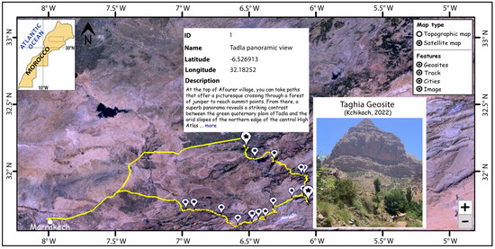
Figure 2.
An example of an interactive map created using code developed in R software.
2.2. Visitor Typology Analysis
The comprehensive literature review on the attractiveness of mountain tourist circuits worldwide, as mentioned in our Section 2 based on sources such as [3,4,13,14], has helped us to design an initial list of criteria for choosing destinations in the High Atlas Mountains. Other specific criteria to this region have been added following an initial series of interviews with tourism professionals and operators in the area. These interviews involved mainly guides, accommodation managers or owners, and tourists encountered during our initial field trip. Face-to-face interviews were particularly valuable in identifying the essential needs that visitors consider when choosing their destination along the studied circuit and its sub-circuits. The interviewees completed the questionnaires themselves, which not only included detailed accounts of their visits to the circuit but also suggestions for new criteria to be added to the questionnaire. This process led us to identify 34 criteria for this quantitative assessment, available at https://forms.gle/eijD2wghK1oDzYNi9.
The questionnaire was then the subject of a fifteen-month field survey from June 2022 to September 2023. Interviews were conducted face to face, via email, WhatsApp, or Facebook. The face-to-face interviews included tourists (mainly foreigners) encountered on the circuit during field visits, as well as attendees of the 10th International Conference on UNESCO Global Geoparks, held in Marrakech from September 5 to 11, 2023. We also engaged with professionals such as guides, hostel managers, and lodging owners, either on-site or at their tourism agencies in Marrakech. Additionally, the questionnaire was made available online through the Google Forms application and shared across social networking sites. A URL link to the questionnaire was also created and emailed to 117 individuals involved in rural tourism in the central High Atlas Mountains. Furthermore, we encouraged everyone we contacted—whether through social networks, email or in person—to further distribute the questionnaire within their networks (including Facebook discussion groups, WhatsApp groups, association members, and specialist forums).
Respondents were asked to complete a two-part questionnaire. The first part collected metadata, asking about their status (professional or casual visitor), gender, whether they were from Morocco or abroad, traveling individually or in a group, the number of sites visited from the thirteen selected in this study, and the duration of their experience on the tourist itinerary. These qualitative criteria were treated as modalities in our statistical analysis. Each participant was then required to rate each of the 34 criteria being surveyed on a scale of 1 to 5, available at https://forms.gle/eijD2wghK1oDzYNi9. We intentionally used a uniform rating scale to facilitate a comparative analysis of how each criterion influences the consumer experience during visits to the studied circuits and sub-circuits. The quantitative variables obtained were utilized in the statistical analysis of the collected data.
We analyzed the collected responses using R software, specifically employing the FactoMineR [15,16] and factoextra [17] packages. These tools are highly suitable and user-friendly for conducting efficient Principal Component Analysis (PCA). PCA is a multidimensional reduction technique widely used in data analysis to distill and represent the information from large datasets, as in our study. We started by importing our data into the R environment, followed by a thorough preparation process which included removing duplicate entries, filtering outliers, normalizing data, encoding categorical data, and checking errors. Subsequently, we conducted the PCA using FactoMineR and the factoextra packages, which generated high-quality graphs to visually represent our analytical results.
The primary objective of our case study was to explore the extent of similarity among individuals based on their evaluations of different variables. We aimed to determine whether it is feasible to cluster the sample into groups when notable similarities among several participants are observed. Specifically, our goal was to classify visitors to the central High Atlas into distinct types, creating homogeneous groups that are consistent across all considered variables. To achieve this, we employed standard techniques commonly used in multivariate data analysis. These included Principal Component Analysis (PCA), Hierarchical Clustering, and the K-Means method [18,19,20]. Given the specific characteristics of our data, we opted for the Hierarchical Clustering on Principal Components (HCPC) approach [18]. This method integrates the strengths of the three techniques described above, making it particularly effective for identifying underlying patterns in complex datasets. Additionally, we investigated the linear relationships between the variables under study by calculating the Pearson correlation coefficients [21]. This analysis helped us to identify groups of highly correlated variables, which we then organized into distinct dimensions. These dimensions served as the basis for our clustering analysis, enabling us to systematically group the visitors based on shared attributes and preferences.
In total, we recorded responses from 767 individuals who completed our questionnaire. Following a descriptive analysis of this sample, we conducted HCPC analysis on the 34 variables identified in our field survey to delineate the main dimensions of the desired consumer experience. We then converted the total scores for each criterion into a percentage to reflect the relative importance of each as a motivational factor for the experience. This weighting also serves as an indicator of the criterion’s influence on the destination choice for future tourists.
We categorized each criterion (variable) into a group, referred to as a “Factor”. We then determined the weight that each “Factor” contributes to the dimension of the consumer experience desired by visitors. To standardize the weights of the 34 criteria under study, we recalculated their internal weights within each “Factor”, ensuring that the sum of the internal weights for the criteria within the same “Factor” equals 100%. Similarly, the sum of the weights across all “Factors” also totals 100%.
3. Results and Discussion
3.1. Geosite Features
We have compiled datasheets for thirteen geosites. These datasheets are accessible by clicking on the appropriate site markers on the interactive map created using R software, available online at https://geositekch.blogspot.com/2024/04/geosite.html. In this paper, we feature only three of these to showcase the type of data developed and made available online. They correspond to the geological sites of Imi-n-Ifri, Ait Bouguemez valley, and Imsfran Cathedral (Figure 1b; markers 1, 5 and 11).
3.1.1. Imi-n-Ifri Natural Bridge (X = 6°58′18″; Y = 31°43′26″; Z = 1069 m)
After leaving the village of Demnate, the R307 road traverses a forest predominantly composed of juniper trees growing on a substrate of red clay and weathered Triassic basalt The Imi-n-Ifri natural bridge, which lacks any piers or abutments, forms a completely natural crossing (Figure 3a,b). This bridge corresponds to a natural cave that is open on both the north and south sides, carved into travertine with a thickness exceeding 50 m. Visitors can descend to the bottom of the thalweg and observe the shapes of this natural arch by following a narrow path equipped with pseudo-stairs. From the cave floor, the stages of travertine formation can be easily deduced within a geological setting dominated by Lower Jurassic carbonates (approximatively 180 million years ago, as shown in the simplified geological section (Figure 3c). At the Imi-n-Ifri site, the travertine formation occurred during the Quaternary period (approximatively 0.5 million years ago) [22,23,24,25,26].
Travertine typically exhibits a yellow or brown color and has a vacuolar texture. When altered, the rock assumes a tuffaceous appearance. This type of rock forms predominantly in regions characterized by dominant carbonate (CaCO3) formations. The leaching of the carbonates by meteoric waters, which are often aggressive, dissolves chemical elements such as Ca2+ and HCO3−. Upon reaching saturation, these elements precipitate in the form of deposits at springs or river waterfalls. Additionally, the cave features exceptionally fine stalagmites and stalactites. Passing under the natural bridge, we encounter large water springs. These are stratigraphically positioned at the contact between the Triassic red clays and the overlying Lower Liassic limestone beds. They drain a karst network developed within the Lias’s limestone [27,28].
Located about 6 km beyond the Imi-n-Ifri natural bridge, the Iwariden site is renowned for its dinosaur footprints. These tracks are exceptionally well preserved in a silty sandstone formation known as the “Couches Rouges”, approximately 160 million years old [24,29]. Two distinct types of footprints are observable: large oval ones from the feet of large herbivorous dinosaurs, and smaller, bird-like (tridactyl, three-toed) prints attributed to smaller carnivorous dinosaurs (Figure 3d). The presence of these tracks in this red continental formation provides clear evidence of the environmental conditions that existed in this region of the High Atlas around 160 million years ago. Researchers [30,31] have identified these footprints as belonging to Megalosauripus, a bipedal theropod dinosaur averaging 1.5 to 2 m in height, which was widespread in various regions (Portugal, Spain, America, Morocco, etc.) closely connected during the Jurassic period.
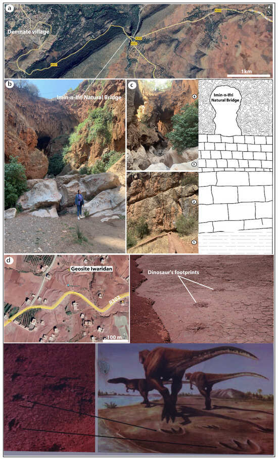
Figure 3.
(a) Location of Imi-n-Ifri natural bridge. (b) North side of the geosite showing tunnel dug by river through travertine under R307. (c) Schematic geological section: 1. Triassic red clay (200 Ma); 2. Lower Jurassic massive limestone and dolomite beds (−190 Ma); 3. Lower Jurassic laminated limestones (−185 Ma); 4. Quaternary travertines (−0.5 Ma); ages of the geological formations are given in [29,31]. (d) Dinosaur tracks in the Iwariden geosite.
3.1.2. Ait Bouguemez Valley (X = 6°31′38″; Y = 31°37′59″; Z = 2080 m)
A visit to the Happy Valley of Ait Bouguemez, which is nestled at an elevation of 1800 m in the Moroccan central High Atlas Mountains, offers a purely natural experience. The valley stretches thirty kilometers along the slopes of the M’Goun, Azourki, and Rat mountains (locally known as Djebels), where erosion has sculpted a breathtaking landscape. Today, it is a vibrant garden where colors magically play out in the different shades of green from terraced crops, the pristine white of snow-capped peaks, and the dazzling blue of the sky above (Figure 4a).
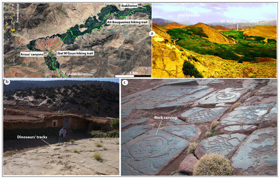
Figure 4.
(a) Location of the two main hiking trails in the Ait Bouguemez valley (Google Earth image 2023). (b) Example of a geosite in the valley showing traces of dinosaurs. (c) Several sites of rock carvings that also can be visited in the valley.
During the winter season, when snowfall is plentiful, enthusiasts are well served by the slopes surrounding the valley, which feature well-maintained natural ski trails. In spring, visitors can immerse themselves in nature, walking along easy paths that weave through vibrant fields, creating a mosaic of breathtaking colors. The valley also offers several gentle walks and mountain bike trails that follow the meandering river through the Arous canyons and waterfalls (Figure 4a). The mountain lodges, which host thousands of tourists annually, provide more challenging hikes as well. These include the ascents of Djebels M’Goun (4068 m), Azourki (3677 m), and Rat (3797 m), and longer treks such as from Ait Bouguemez to the Tassaout river near Demnate (10 days), or from the valley to the village of Imilchil (12 days).
The geomorphology of the Ait Bouguemez region is significantly shaped by its geological structure: Elongated summit ridges are formed by the anticlinal axes, while the main valley and its subsidiary valleys are nestled within the synclines. In this region, inverted reliefs with perched synclines, such as Jbel Rat, and various erosional features like gullies and ravines, including Arous, create striking landscapes. At certain locations, such as at the southwest entrance to the valley, steep and nearly inaccessible cliffs loom over the road. These cliffs and ledges consist of massive limestone blocks from the Ait Abdi Formation, which dates back to the Aalenian–Bajocian period (over 170 million years ago, [32]). Additionally, some glacial deposits at the base of the slopes help us understand the freeze–thaw cycles that enriched the valley with nutrient-rich Quaternary deposits.
From a geological point of view, the Ait Bouguemez valley is rich with numerous geological sites of significance, including many dinosaur tracks. In the village of Ibakliwine, two types of dinosaur traces can be observed on a gently sloping limestone layer: large oval tracks from gigantic herbivorous dinosaurs and tridactyl tracks from carnivorous dinosaurs (Figure 4b). These footprints date back 180 million years, to a time when the region was comprised of muddy lagoons frequented by dinosaur groups [33]. Additionally, at Tizi-n-Tighist, engravings on Triassic sandstone depict horsemen with spears and shields in scenes of invasion, combat, and hunting. These carvings are estimated to be from around 3500 to 4000 years ago, dating back to the Bronze Age (Figure 4c).
3.1.3. Imsfran Cathedral (X = 6°8′55″; Y = 31°59′37″; Z = 1272 m)
Located towards the end of the tourist circuit, between the renowned villages of Zaouiat Ahansal and Tilouguite, this spectacular natural site features an imposing cliff that overhangs Oued Ahansal by more than 600 m (Figure 5). This massive rock formation, dating from the Miocene to the Pliocene (approximately 2 to 10 million years ago, [34,35,36]), consists of conglomerates and sandstones. These sediments, produced by the erosion of the Atlas Mountains, have been sculpted by natural processes into the impressive silhouette of a medieval church, leading to its nickname “the cathedral”, as termed by [37].
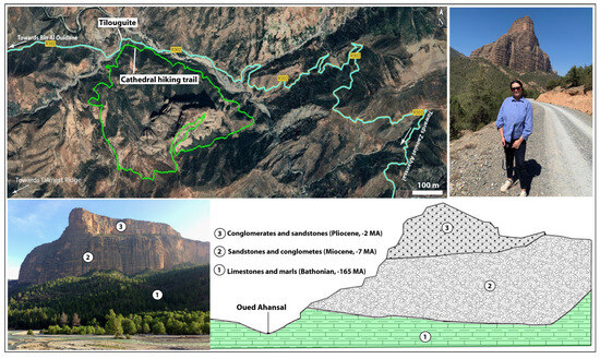
Figure 5.
Location and schematic geological cross section of the Imsfran Cathedral site.
The Imsfran Cathedral site is remarkable not only for the splendor of its geological formations but also for the striking color contrasts it presents: the brown of the rocks, the green of the Aleppo pines, and the red of the earth in various places. It is an ideal location for capturing memorable photos from the surrounding peaks. The area attracts both amateur hikers, who appreciate the panoramic views from the base of the cathedral, and experienced hikers, who venture to the summit. Additionally, others enjoy exploring the gorges of Oued Ahansal, where the towering limestone cliffs gradually narrow, providing spectacular and sublime views of the river.
From the summit of Imsfran Cathedral rock, visitors can enjoy a view dominated by the Talmest Ridge (Figure 6). This ridge represents a faulted anticline structure featuring injections of Triassic red clay and magmatic rocks. It is encircled by calcareous formations of the lower, middle, and upper Lias, each showing distinctly different dips from the south to the north side of the anticline. The Miocene–Pliocene conglomerates and sandstones of the Imsfran rock rest against the northern flank of this structure. These formations were elevated to their present heights by the Atlas orogeny and subsequently shaped by erosion into their current spectacular forms. Additionally, visitors may explore the nearby zinc mine, which contains mineral deposits embedded in the carbonates of the Lower Lias [35].
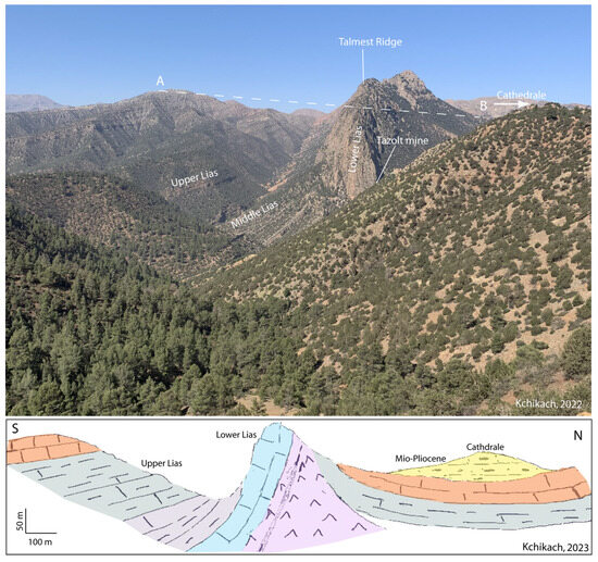
Figure 6.
Geological section across Talmest ridge (see location Figure 5).
3.2. Visitor Typology Analysis
Table 1 provides a descriptive analysis of the respondents to our questionnaire. It reveals that the sample predominantly consists of younger individuals (over 62% are under 45 years old) and males (66.62%). Typically, visitors to the circuits and sub-circuits travel in groups of friends (62.71%) and stay in the area for at least two days (more than 85%). Additionally, more than 78% of the visitors had the opportunity to visit at least three of the 13 selected geosites during their trip. Despite extensive efforts to distribute our questionnaire widely—having posted it online via Google Forms and on social networks for approximately 15 months—only 16.95% of foreign visitors participated in the survey. This suggests that the mountain tourism circuit may not be well known or effectively marketed internationally.

Table 1.
Qualitative modalities and descriptive analysis of the sample (767 individuals) used for the quantitative evaluation of the 34 criteria for the choice of the destination “central High Atlas in Morocco”. M: Male; F: Female; Y: Yes; N: No.
Conformity and homogeneity tests for the quantitative variables, conducted using R software, did not lead to the exclusion of any variables. Consequently, all the variables were included in the quantitative analysis of the collected data. Table 2 displays the overall score, mean, standard deviation, and weight of each variable in influencing respondents’ choice of destination and experience. Note that apart from the variables V12, V15, V16, V110, V111, and V33, which show an average standard deviation, the evaluations of all other variables are closely clustered around their mean “values”. This consistency in responses underscores the quality and reliability of the findings from this study.

Table 2.
Codes and statistics for the studied factors and variables.
Using R software for interactive analysis and calculating Pearson’s correlation coefficient [2,21] (Figure 7a), we grouped the studied variables into five factors. These factors help interpret the needs and desires of visitors when choosing the studied central High Atlas tourist circuit. Detailed descriptions of each factor and their respective contributions to the destination’s attractiveness are provided in Table 2.
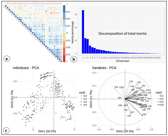
Figure 7.
(a) Correlation between the studied variables (the larger the circle diameter, the closer the correlation coefficient to 1). (b) Distribution of the total inertia of the collected dataset. (c) Representation of individuals and variables in the 1:2 factorial plane (The cos2, which is approximately greater than 0.6, expresses the representativeness of individuals and variables in this plane).
The factor “attributes of the territory“ contributes significantly to the choice of the central High Atlas as a tourist destination, accounting for over a third (36.96%) of the overall decision-making weight. This factor addresses the fundamental needs and expectations of visitors at high mountain tourist destinations, highlighting that rural tourism in mountainous areas requires a comprehensive approach. It must encompass all aspects, including access to the area, safety, and the overall enjoyment and hedonism experienced by tourists. The internal consistency among its 13 variables is robust, with an average coefficient of 0.87. These results are consistent with findings reported by [3,4,13,14].
The factor ‘cultural wealth and hospitality of the local people’ was ranked second, illustrating that visitors to the central High Atlas region are drawn not only by its pristine natural environment and the availability of essential services but also by the cultural richness and hospitality of the local Amazigh population. This factor, accounting for 20.11% of the overall score, highlights visitors’ desire to engage directly with locals, enjoy shared moments, and immerse themselves in the community’s customs, traditions, and lifestyle. This determination aligns well with the growing trend toward sustainable rural tourism. Correlation among variables in this factor is very high (0.91).
The geographical layout and the stunning vistas of the area significantly contribute to its tourist appeal. Despite having only six variables, the third factor—termed “beauty of landscape resources”—accounts for 19.16% of the criteria. The fourth factor, comprising five variables, focuses on the role of geological heritage in drawing visitors to the central High Atlas region (geotourism). This factor represents 13.92% and reflects the growing awareness and appreciation of the region’s unique geosites, especially following the designation of the M’Goun Geopark as a “Global Geopark Network” by UNESCO in 2014. However, considering the uniqueness and international significance of the region’s geosites [1], this weighting seems moderate. It suggests that the region’s geoheritage is still underrecognized, and substantial efforts are required to highlight its visibility. Lastly, the fifth factor, which involves biodiversity in the choice of destination, highlights the interest in the local flora and the distribution of species within the altitude, contributing 9.85% to the decision-making process.
Before conducting the PCA analysis of the collected data, we first performed an inertia distribution analysis using R software. This analysis helps to determine the structure of the variables and suggests the optimal number of principal components to consider. As shown in Figure 7b, the first two factorial axes account for 44.94% of the total inertia of the dataset. This indicates that 44.94% of the overall variability among the variables or individuals is well represented in this plane (Figure 7c).
To better correlate groups with field survey modalities, we characterized each corresponding point cloud by its barycenter (Figure 8a). The PCA analysis identified four distinct groups of individuals (clusters, Figure 8b). For instance, we found that foreign visitors and those traveling with their families predominantly fall within group 2. Meanwhile, younger individuals, particularly those under the age of 45, are more likely to be categorized in group 1.
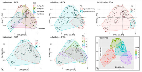
Figure 8.
(a). Distribution of each category and corresponding barycenter in the 1:2 factorial plane. (b). Visitor groups identified by HCPC analysis. M: Male; F: Female; Y: Yes (from abroad); N: No (from Morocco).
- Young sports enthusiasts with passion for the summit conquests
This group comprises individuals under the age of 45 who are driven by adventure and the thrill of conquering the region’s summits. Their main motivations include the desire to surpass personal limits and the experience of escapism. These individuals actively design and produce their own exhilarating experiences. Typically, they travel with friends and are often part of the organized hiking groups. They are attracted to the freedom of the mountain environment and enjoy the physical challenge it presents.
The visibility of this group on social networking sites greatly facilitated their participation in our field survey. Constituting the largest visitor segment to the central High Atlas region, they represent 62.71% of our sampled population. They scored highest on variables V15, V18, V19, V24, and V25, which reflect the criteria “Feeling of overcoming the difficulty of the hike”, “Pleasure of walking in virgin nature”, “Leisure activities and entertainment”, “Feeling the majesty of high peaks” and “Discovering unspoiled nature”, respectively. These results indicate that their primary motivations are to challenge their physical limits, enjoy celebrations with friends, and experience the awe of the natural landscape. Most respondents in this group had visited over six of the thirteen geosites featured in this study. In terms of cultural interests, they showed moderate engagement: their average score on the variables of the fifth factor was 4.32, compared to the overall sample average of 4.79.
- 2.
- Families and tourists inspired by culture and landscape
This group consists of discerning customers who seek a tranquil experience in unspoiled nature, prioritizing basic services and safety without the need for sporting challenges. They recorded high scores on variables V11, V12, V13, V14, V17, V18, V19, V112, V113, V21, V25, V32, V42, and all variables in the fifth factor (see Table 2). This indicates that they prefer to explore the area in a calm and quiet manner, focusing on maintaining a gentle interaction with the environment and socializing. Most of these tourists, including both foreign and Moroccan visitors who come with their families, typically spend more than 48 h in the region. Unlike the younger sports enthusiasts, this group predominantly consists of an older demographic (over 65 years old) and has a significant proportion of women (59/141 or 41.84%). They comprise 18.39% of the sampled individuals.
- 3.
- Geotourism enthusiasts
This group, representing 10.7% of our sample. They recorded high scores on variables V21, V25, V32, V35, V42, V51, V53, and V56, indicating a strong interest in integrating natural, cultural, and geological environments into their travel experiences. Typically, their stays range from 48 to over 72 h, suggesting that they dedicate significant time to studying the unique geological sites along the tourist route. Additionally, they often choose accommodations with local families to immerse themselves in and appreciate the cultural heritage of the region.
- 4.
- Visitors looking for leisure activities
This group, which comprises 8.2% of our sample, showed high scores on variables V18, V19, V113, V42, and V43, indicating a strong interest in leisure activities such as hunting, fishing, rafting, jet skiing, climbing. Their primary goal is to escape everyday life, seeking experiences that combine physical activity with mental engagement, like learning new hobbies or exploring new cultures through group activities. Typically, their visits are brief, usually lasting less than 24 h, and they tend to explore fewer than 3 of the 13 geosites mentioned in this study.
Statistical analysis of the survey data has successfully identified five factors of destination choice and four distinct groups of visitors. The weights assigned to various motivational criteria and factors influencing destination choice emphasize the significance of the region’s intrinsic attributes. These include high-altitude peaks, magnificent panoramic views, cultural richness, and the hospitality of the residents. In addition, to seeking thrilling experiences and indulging in hedonism, visitors also value the unique cultural aspects and the specific geological features of the region.
Paradoxically, our results indicate that criteria related to well-being and safety are not heavily prioritized when selecting a destination. This phenomenon can be explained by the fact that visitors, particularly the predominantly young individuals in group 1, often travel in groups and prefer the adventure of camping in the countryside over concerns for safety and comfort. Additionally, group 3, which mainly consists of leisure enthusiasts, spends only their daytime exploring specific sections of the tourist circuit and returns to larger nearby cities such as Marrakech, Beni Mellal, or Azilal for overnight stays. Consequently, the availability of essential services and safety are not significant concerns for them.
The Section 2 of this study employed an experiential approach to objectively measure and quantify visitor expectations when traveling to this destination. This method was both deductive and quantitative. Initially, we defined the factors that influence destination choice, identifying five key factors. Subsequently, we categorized visitors into four groups based on their preferences and behaviors within the tourist circuit. The results of this study are highly valid and enable a detailed exploration of the emotional factors that influence tourists’ decisions to visit mountain tourism destinations in the central High Atlas of Morocco.
We assert that customer segmentation based on consumer experience is an extremely valuable tool. It not only facilitates a precise examination of specific customer expectations but also provides tourism operators with essential insights for crafting suitable offers. Operators should prioritize criteria that receive the highest ratings to ensure they are preserved and improved. Conversely, they should also focus on improving variables that receive the lowest ratings. In our study, the emphasis is on maintaining and enhancing primarily objective and rational variables. These criteria are particularly relevant for group 1, which constitutes the majority of our sample. Additionally, our approach may help in developing strategies to minimize visitor dissatisfaction. Our results support and expand upon previous research in the evaluation of geosites, mountain tourist routes, and visitor profiling at such destinations [3,4,13,14,38,39,40,41].
4. Conclusions
Interestingly, the value of a destination’s resources has an important contribution to its tourism development potential. This study allowed us to create digital documents about the main tourist route in the M’Goun UNESCO Global Geopark and advertise them through an interactive map made available online. Additionally, we propose a comprehensive index system to assess the “value” of these resources based on recreation experiences. Implementation of such an approach is a notable aspect of our study.
Visitor typology analysis demonstrates that five factors influence tourists’ destination choices. They correspond to the territory attributes, natural landscape, cultural heritage, and geological and biological features. Their % weights are 36.96, 20.11, 19.16, 13.92, and 9.85, respectively. Our findings are consistent with those reported in previous studies [3,4,13,40,41]. The higher the percentage is, the better the resource is, and the stronger the tourism development ability is.
The findings of this research could have practical implications and may constitute an essential basis for managing tourism destinations in the central High Atlas of Morocco. They can help local governments and operators to rationally allocate tourism resources and land use in this region with strong potential for tourism competition in the Mediterranean area. It is clear that young potential visitors, who accounted 62% of our sample, need to be the focus of most marketing efforts. For instance, it is recommended that a targeted approach be employed to engage this specific demographic of tourists through the organization of regular outdoor events. Also, stakeholders and tourist operators have to work on the establishment of connections between the groups of young Moroccans who participated in our field survey and their peers worldwide.
While this study provides valuable insights, there are a few limitations that suggest promising directions for future research. The first limitation is the sample size; despite extensive efforts over 15 months, the study only includes 767 individuals. For a more valid customer segmentation based on consumer experience, a larger sample size is crucial. Another constraint is the inclusion of both ordinary tourists and tourism professionals (such as guides and accommodation owners) in the survey. The responses from industry insiders might be biased as they could preferentially rate criteria to promote the destination. Therefore, future studies should exclude these participants to prevent such biases. Finally, face-to-face interviews should be prioritized over Internet surveys, as data collected through online platforms can be unreliable [42,43,44,45,46]. Additionally, it would be insightful to expand this research to include university students and schoolchildren to explore their expectations and how the studied circuit could be transformed into an educational resource.
Author Contributions
Conceptualization, N.K., H.I. and A.C.; methodology, N.K., H.I., A.C. and A.B.; software, N.K., A.E.A.E.F., A.C. and H.I.; validation, N.K., H.I. and A.B.; formal analysis, N.K., H.I., A.B. and A.C.; investigation, N.K., H.I., A.C. and A.B.; resources, N.K., A.C., A.E.A.E.F., H.I. and A.B.; data curation, N.K., A.C., A.E.A.E.F., H.I. and A.B.; writing—original draft preparation, N.K., A.C., H.I., A.B. and A.E.A.E.F.; writing—review and editing, H.I., A.B. and A.C.; visualization, N.K., A.C., A.E.A.E.F. and H.I.; supervision, H.I. and A.B.; project administration, H.I. and A.B.; funding acquisition, H.I. and A.B. All authors have read and agreed to the published version of the manuscript.
Funding
This research was funded by the Moroccan Ministry of Higher Education, Scientific Research and Innovation and the OCP Foundation within the framework of the APRD research program.
Data Availability Statement
The authors do not have permission to share data.
Acknowledgments
This research was carried out as part of the project APRD IMAPHOS, funded by the OCP Foundation. Thanks are addressed to the tourist guide associations of the central High Atlas for their help and their technical assistance throughout our research. We would like to express our gratitude to all those who responded to our field survey.
Conflicts of Interest
The authors declare no conflicts of interest.
References
- Errami, E.; Brocx, M.; Semeniuk, V. From Geoheritage to Geoparks Case Studies from Africa and Beyond; Springer: Berlin/Heidelberg, Germany, 2009. [Google Scholar] [CrossRef]
- R Development Core Team. R: A Language and Environment for Statistical Computing; R Foundation for Statistical Computing: Vienna, Austria, 2021; Available online: https://www.R-project.org/ (accessed on 23 November 2023).
- Raadik, J.; Cottrell, S.P.; Fredman, P.; Ritter, P.; Newman, P. Understanding Recreational Experience Preferences: Application at Fulufjället National Park, Sweden. Scand. J. Hosp. Tour. 2010, 10, 231–247. [Google Scholar] [CrossRef]
- Raadik, J.; Cottrell, S. Reconstructing a visitor typology based on recreation experiences. Matkailututkimus 2007, 3, 53–71. [Google Scholar]
- Oiry-Varacca, M. From trekking to heritage tourism: Identity, a lever for the territorial reconstruction of the Aït-Bouguemez valley, High Atlas, Morocco. EDYTEM. Cah. Géographie 2013, 14, 45–56. [Google Scholar] [CrossRef]
- Trukhachev, A. Methodology for Evaluating the Rural Tourism Potentials: A Tool to Ensure Sustainable Development of Rural Settlements. Sustainability 2015, 7, 3052–3070. [Google Scholar] [CrossRef]
- Tranquarda, M.; Riffonb, O. Démarche d’attribution du statut international de géoparc: Proposition d’une méthodologie d’analyse multicritère pour l’évaluation du potentiel des territoires et l’intégration des objectifs de développement durable. Organ. Territ. 2018, 27, 43–62. [Google Scholar] [CrossRef]
- Neto de Carvalho, C.; Baucon, A.; Bayet-Goll, A.; Belo, J. The Penha Garcia Ichnological Park at Naturtejo UNESCO Global Geopark (Portugal): A geotourism destination in the footprint of the Great Ordovician Biodiversification Event. Geoconserv. Res. 2021, 4, 70–79. [Google Scholar]
- Billand, A. Développement touristique des parcs de montagne au Maroc: Principes de zonage et d’aménagement. Rev. Géographie Alp. 1996, 84, 95–108. [Google Scholar] [CrossRef]
- Cayla, N.; Duval-Massaloux, M. Le géotourisme: Patrimoines, pratiques, acteurs et perspectives marocaines. EDYTEM. Cah. Géographie 2013, 14, 101–116. [Google Scholar] [CrossRef]
- Toufik Ait Omar. Les Géopatrimoines de la Partie Nord-Est du Géoparc Régional du M’Goun (Moyen et Haut Atlas Central, Maroc): Inventaire, Evaluation et Valorisation. Géographie. Université d’Angers; Université Sultan Moulay Slimane (Beni Mellal, Maroc) 2021, Français. ffNNT: 2021ANGE0095ff. fftel-04047867. Available online: https://libreo.ch/view/507452/3161705/Geo-regards_14_157.pdf (accessed on 13 May 2024).
- Elkaichi, A.; Errami, E.; Patel, N. Quantitative assessment of the geodiversity of M’Goun UNESCO Geopark, Central High Atlas (Morocco). Arab. J. Geosci. 2021, 14, 2829. [Google Scholar] [CrossRef]
- Rid, W.; Ezeuduji, O.-I.; Probstl-Haider, U. Segmentation by motivation for rural tourism activities in The Gambia. Tour. Manag. 2014, 40, 102–116. [Google Scholar] [CrossRef]
- Chen, Y.; Li, Y.; Gu, X.; Chen, N.; Yuan, Q.; Yan, M. Evaluation of Tourism Development Potential on Provinces along the Belt and Road in China: Generation of a Comprehensive Index System. Land 2021, 10, 905. [Google Scholar] [CrossRef]
- Husson, F.; Lê, S.; Pagès, J. Analyse de Données avec R; Presses Universitaires de Rennes: Rennes, France, 2009; Available online: http://factominer.free.fr/index_fr.html (accessed on 7 December 2023).
- Le, S.; Josse, J.; Husson, F. FactoMineR: An R Package for Multivariate Analysis. J. Stat. Softw. 2008, 25, 1–18. [Google Scholar] [CrossRef]
- Kassambara, A.; Mundt, F. Factoextra: Extract and Visualize the Results of Multivariate Data Analyses. R Package Version 1.0.7. 2020. Available online: https://CRAN.R-project.org/package=factoextra (accessed on 2 January 2024).
- Szekely, G.; Rizzo, M. Hierarchical Clustering via Joint Between-Within Distances: Extending Ward’s Minimum Variance Method. J. Classif. 2005, 22, 151–183. [Google Scholar] [CrossRef]
- Jain, A.K. Data clustering: 50 years beyond k-means. Pattern Recognit. Lett. 2010, 31, 651–666. [Google Scholar] [CrossRef]
- Husson, F.; Josse, J.; Pagès, J. Principal component methods—Hierarchical Clustering—Partitional Clustering: Why Would We Need to Choose for Visualizing Data? Technical Report—Agrocampus. 2010. Available online: http://www.sthda.com/english/upload/hcpc_husson_josse.pdf (accessed on 3 October 2023).
- Sedgwick, P. Pearson’s correlation coefficient. BMJ 2012, 345, e4483. [Google Scholar] [CrossRef]
- Le Marrec, A. Carte géologique du Maroc au 1/100,000, feuille de Demnat. Notes Mémoires Serv. Géologique Maroc 1985, 338. [Google Scholar]
- Jenny, J. Carte géologique du Maroc au 1:100,000, feuille Azilal. Notes Mémoires Serv. Géologique Maroc 1985, 339. [Google Scholar]
- Haddoumi, H.; Charrière, A.; Mojon, P.O. Stratigraphie et sédimentologie des « Couches rouges » continentales du Jurassique- Crétacé du Haut Atlas central (Maroc): Implications paléogéographiques et géodynamiques. Geobios 2010, 43, 433–451. [Google Scholar] [CrossRef]
- Charrière, A.; Ibouh, H.; Haddoumi, H. Circuit C7, Le Haut Atlas central de Beni Mellal à Imilchil. In New Geological and Mining Guidebooks of Morocco; Michard, A., Saddiqi, O., Chalouan, A., Rjimati, E., Mouttaqi, A., Eds.; Notes et Mémoires du Service géologique du Maroc: Rabat, Morocco, 2011. [Google Scholar]
- Guezal, J.; El Baghdadi, M.; Barakat, A. Les basaltes de l’Atlas de Béni-Mellal (Haut Atlas Central, Maroc): Un volcanisme transitionnel intraplaque associé aux stades de l’évolution géodynamique du domaine atlasique. Anuário Instit Geociê 2013, 36, 70–85. [Google Scholar] [CrossRef]
- Hancock, P.L.; Chalmers RM, L.; Altunel, E.; Çakir, Z. Travitonics: Using travertines in active fault studies. J. Struct. Geol. 1999, 21, 903–916. [Google Scholar] [CrossRef]
- Pentecost, A. Morphology and Facies. In Travertine; Springer: Dordrecht, The Netherlands, 2005. [Google Scholar] [CrossRef]
- Souhel, A. The Mesozoic in the High Atlas of Beni Mellal (Morocco): Stratigraphy, Sedimentology and Geodynamic Evolution. Ph.D. Thesis, Universite Cadi Ayyad, Marrakech, Morocco, 1996. [Google Scholar]
- Nouri, J.; Dıaz-Martınez, I.; Perez-Lorente, F. Tetradactyl Footprints of an Unknown Affinity Theropod Dinosaur from the Upper Jurassic of Morocco. PLoS ONE 2011, 6, e26882. [Google Scholar] [CrossRef] [PubMed]
- Boutakiout, M.; Hadri, M.; Nouri, J.; Diaz-Martinez, I.; Perez-Lorente, F. Rastrilladas de icnitasterópodas gigantes del-Jurásico Superior (Sinclinal de Iouaridène, Marruecos). Rev. Esp. Paleontol. 2009, 24, 31–46. [Google Scholar] [CrossRef]
- Bussard, J.; Martin, S.; Monbaron, M.; Reynard, E.; El Khalki, Y. Les paysages géomorphologiques du Haut Atlas central (Maroc): Potentiel éducatif et éléments pour la médiation scientifique. Géomorphologie 2022, 28, 173–185. [Google Scholar] [CrossRef]
- Boutakiout, M.; Masrour, M.; Ladel, L.; Diaz-Martinez, I.; Pérez Lorente, F. Nuevos yacimientos de icnitas domerienses en Ibaqalliwn (Alt Bou Guemez, Alto Atlas Central, Marruecos). Geogaceta 2010, 48, 91–94. [Google Scholar]
- Ibouh, H. Tectonique en Décrochement et Intrusions Magmatiques au Jurassique; Tectogenèse Polyphasée des Rides Jurassiques d’Imilchil (Haut Atlas Central, Maroc). Ph.D. Thesis, Universite Cadi Ayyad, Marrakech, Morocco, 1995. [Google Scholar]
- Ibouh, H. Du rift Avorté au Bassin sur Décrochement, Contrôles Tectonique et Sédimentaire Pendant le Jurassique (Haut Atlas Central, Maroc). Ph.D. Thesis, Universite Cadi Ayyad, Marrakech, Morocco, 2004. [Google Scholar]
- Ibouh, H.; Chafiki, D. La tectonique de l’Atlas: Âge et modalités. S. G. F. Géologues 2017, 194, 24–28. [Google Scholar]
- Roch, E. Description géologique des montagnes à l’Est de Marrakech. Notes Mémoires Serv. Des Mines Cart. Géologique Maroc 1939, 51, 438. [Google Scholar]
- Hosany, S.; Martin, D.; Woodside, A.G. Emotions in Tourism: Theoretical Designs, Measurements, Analytics, and Interpretations. J. Travel Res. 2020, 60, 1–17. [Google Scholar] [CrossRef]
- Bastiaansen, M.; Straatman, S.; Driessen, E.; Mitas, O.; Stekelenburg, J.; Wang, L. My destination in your brain: A novel neuromarketing approach for evaluating the effectiveness of destination marketing. J. Destin. Mark. Manag. 2016, 7, 76–88. [Google Scholar] [CrossRef]
- Bakhtiyari, K.; Husain, H. Fuzzy Model on Human Emotions Recognition. In Proceedings of the 12th WSEAS International Conference on Applications of Computer Engineering (ACE ‘13), Cambridge, MA, USA, 30 January–1 February 2013. [Google Scholar] [CrossRef]
- Hosany, S.; Gilbert, D. Measuring Tourists’ Emotional Experiences toward Hedonic Holiday Destinations. J. Travel Res. 2010, 48, 513–526. [Google Scholar] [CrossRef]
- Li, S.; Cui, T.; Alam, M. Reliability analysis of the internet of things using Space Fault Network. Alex. Eng. J. 2021, 60, 1259–1270. [Google Scholar] [CrossRef]
- Brühlmann, F.; Petralito, S.; Aeschbach, L.F.; Opwis, K. The quality of data collected online: An investigation of careless responding in a crowdsourced sample. Methods Psychol. 2020, 2, 100022. [Google Scholar] [CrossRef]
- Ward, M.K.; Pond, S.B. Using virtual presence and survey instructions to minimize careless responding on Internet-based surveys. Comput. Hum. Behav. 2015, 48, 554–568. [Google Scholar] [CrossRef]
- Barratt, M.J.; Ferris, J.A.; Lenton, S. Hidden Populations, Online Purposive Sampling, and External Validity: Taking off the Blindfold. Field Methods 2015, 27, 3–21. [Google Scholar] [CrossRef]
- Aust, F.; Diedenhofen, B.; Ullrich, S.; Musch, J. Seriousness checks are useful to improve data validity in online research. Behav. Res. Methods 2013, 45, 527–535. [Google Scholar] [CrossRef]
Disclaimer/Publisher’s Note: The statements, opinions and data contained in all publications are solely those of the individual author(s) and contributor(s) and not of MDPI and/or the editor(s). MDPI and/or the editor(s) disclaim responsibility for any injury to people or property resulting from any ideas, methods, instructions or products referred to in the content. |
© 2024 by the authors. Licensee MDPI, Basel, Switzerland. This article is an open access article distributed under the terms and conditions of the Creative Commons Attribution (CC BY) license (https://creativecommons.org/licenses/by/4.0/).